Embed Size (px)
Citation preview
�
National
Cooperative
Soil
Survey
Newsletter
November2011Issue57
In This Issue—
Editor’s Note
Issues of this newsletter are available on the World Wide Web (http://soils.usda.gov/). Under Quick Access, click on NCSS, then on Newsletters, and then on the desired issue number.
You are invited to submit stories for this newsletter to Pattie West, National Soil Survey Center, Lincoln, Nebraska. Phone—402-437-5334; FAX—402-437-5336; email—[email protected].
Roadless in AlaskaA Story of Data Collection in the Land of the Midnight Sun
By Dennis Moore, Soil Data Quality Specialist, Natural Resources Conservation Service, Palmer, Alaska; email: [email protected].
During the summer of 20��, the Natural Resources Conservation
Service assisted the Environmental Protection Agency (EPA) with sampling for the National Wetland Condition Assessment. This assessment is one of the EPA’s National Aquatic Resource Surveys, providing the public with a comprehensive view of the condition of the Nation’s waters.
The survey was an action-packed 28-day field tour from July 5 to August 2. Terri Lomax, hydrologist from the Alaska Department of Environmental Conservation, spearheaded the project and coordinated all of the logistics. We were also joined by scientists from the University of Alaska Anchorage’s Natural Heritage Program, including Program Botanist Dr. Matthew Carlson, Ecologist Dr. Dan Rinella, Ecologist Dan Bogan, Ecologist Rebecca S. Shaftel, and
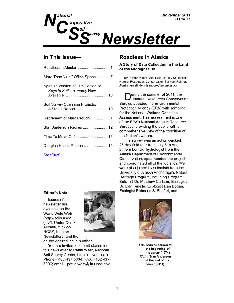
Left: Stan Anderson at the beginning of his career (1974).
Right:Stan Anderson at the end of his career (2011).
Roadless in Alaska ............................... �
More Than “Just” Office Space ............ 7
Spanish Version of ��th Edition of Keys to Soil Taxonomy Now Available ....................................... �0
Soil Survey Scanning Projects: A Status Report ............................. �0
Retirement of Marc Crouch ................��
Stan Anderson Retires ....................... �2
Time To Move On! ............................. �3
Douglas Helms Retires ...................... �4
StanStuff

2
NCSS Newsletter
Botanist Brian Heitz. We also worked with Biologist Gayle Martin from the EPA. Our helicopter pilot was Mr. Adam Good. The vegetation team rotated out about every 9 days, but Terri, Adam, and I stayed on for the whole 28 days. Our charge was to collect data in northern Alaska’s Arctic Coastal Plains, land of the midnight sun. The area is infamous for mosquitoes (often called moosequitoes, claimed by some sourdoughs to be Alaska’s state bird) and for permafrost. See figure 1.
We worked in two teams. The vegetation/biology team was responsible for laying out the assessment area and collecting ecological, botanical, and hydrologic data. The soils team was responsible for describing pedons and collecting soil samples for soil characterization as well as enzyme and isotope analysis. The teams cooperated as necessary to get the job done. Adam, the helicopter pilot, for example, assisted in carrying the 40-pound motor for, and operating the Snow, Ice, and Permafrost Research Establishment (SIPRE) auger on difficult sites.
Our area of investigation was about the size of Kentucky, and we worked out of three base camps—Inigok, a Bureau of Land Management camp; Barrow; and Wainwright. The only road access in the area was in the local villages. The topography consisted of low- and high-center ice-wedge polygons (figs. 2 and 3), rims, and peat mounds on plains dissected by meandering creeks and rivers. Foggy weather often played havoc with our helicopter plans, causing time delays and forcing us to drop nine of our sites.
Our original goal was to complete two assessment areas each day. The assessment of soils was the most time consuming. Originally, the daily protocol was to dig and describe four 60-cm holes in four predetermined vegetation plots and describe and sample the most representative soil to a depth of � meter. Hand digging in strongly cemented permafrost with a tile spade is incredibly laborious and time consuming. After completing our second assessment area, we realized that our original goal was not realistic. We reduced our protocol to two complete �-meter pedon descriptions
Figure 1.—Dennis Moore and Terri Lomax in their daily routine with the auger. The blotches on their clothing are mosquitoes. (Photo by Gayle Martin, EPA)

�
NCSS Newsletter
per day, sampling the first site as most representative of the assessment area. The process was started by Dennis digging a plug from about a 40- by 40-cm hole to the depth of seasonal frost with a tile spade, followed by Terri and Dennis digging the hole to a depth of 100 cm or more with the SIPRE auger (figs. 4 and 5). Soil samples were taken from the 40- by 40-cm plug and the ice core (figs. 6 and 7).
One drawback of a SIPRE auger was that sometimes the complete core did not come out when the auger was removed from the ground. In these cases, the core had to be removed manually from the hole. For soils with standing water, this is complicated by the necessity of completing a one-handed push-up (to keep all clothing from getting saturated) while simultaneously procuring the submerged frozen soil core.
Figure 2.—Aerial view of ice-wedge polygons.
Figure 3.—High-center ice-wedge polygons.

4
NCSS Newsletter
Figure 4.—Terri and Dennis using a SIPRE auger to dig the most northern SCS/NRCS soil pit in the United States (latitude 71.27647o north) on a low-center ice-wedge polygon.
Figure 5.—A SIPRE auger with an undisturbed soil core. The auger uses carbide teeth to cut through frozen soil. Rocks and frozen sand quickly dull the carbide teeth. (Photo by Gayle Martin, EPA)

5
NCSS Newsletter
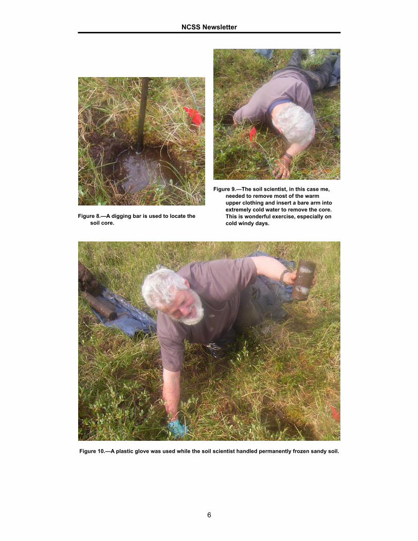
When these procedures are repeated three times in one day, the person retrieving the core gets a case of hyperthermia (figs. 8, 9, and 10).
Another drawback was the water’s thermal conductivity when we dug in submerged soils. The depth to permafrost is greater than 65 cm, and these soils usually have a thawed, saturated, mucky horizon overlying a thawed, saturated, sandy horizon. The soils have very poor strength and were unable to support body weight of three 190-pound-plus men plus the weight and the grueling torque of the spinning SIPRE auger. So, sampling these soils to 1 meter was impossible as we would sink deeper into the soil while trying to pull the auger up. Team members sometimes got stuck while just traversing these soils even if they were not carrying heavy equipment.
One of the most interesting observations was made at the Inigok airstrip and camp area. This site was established by alternating layers of insulating material and gravel to a depth of about 3 meters over the ice-wedge polygons. The areas that were actively
Figures 6 and 7.—Soil samples laid on a tarp for identifying soil horizons, sampling, and photo documentation. Top: Sapric Glacistel; bottom: Historthel.
6
NCSS Newsletter
Figure 9.—The soil scientist, in this case me, needed to remove most of the warm upper clothing and insert a bare arm into extremely cold water to remove the core. This is wonderful exercise, especially on cold windy days.
Figure 8.—A digging bar is used to locate the soil core.
Figure 10.—A plastic glove was used while the soil scientist handled permanently frozen sandy soil.

�
NCSS Newsletter
being maintained were suitable for landing aircraft and for tent sites. About 15 meters from the main tent were areas that were not being maintained. Mother Nature was reestablishing ice-wedge polygons. Some of the depressions between the rims were about a meter deep.
By the end of the tour, we had described �9 different sites. Members of the three vegetation/biology teams asked me about my thoughts on the soils we observed. The dominant texture of the surface layer was peat, and the dominant subsoil texture was sand. The only loamy texture observed was along the coast of the Arctic Ocean. All of the permafrost-affected soils that we sampled were frozen and saturated. These samples were saturated and thawed when sent to the Soil Survey Laboratory in Lincoln. In my professional estimation, if these soils ever thawed because of global warming, they would turn into quicksand until they came into equilibrium. Data from these sites will be used to assess physical and chemical soil characteristics and sequestration of organic carbon and to document the hydrology of the soil landscapes
Figure 11.—Midnight sun reflecting over the Arctic Ocean from the shoreline in Barrow, Alaska.
More Than “Just” Office SpaceBy Linda Greene, ACES enrollee, Natural Resources Conservation Service, National Soil Survey Center,
Lincoln, Nebraska.
Taking pride in who we are and what we do was the motivation behind the recent “sprucing up” of the offices of the National Soil Survey Center (NSSC).
The NSSC is an important part of NRCS, the Federal agency committed to soil conservation. Jon Hempel, the Center’s director, wanted that commitment to become a clear message for anyone who spends time at the Center. With that goal in mind, Hempel turned NSSC gathering places into museum-like spaces designed to inform, inspire, and motivate all who work in or visit the Center.
�
NCSS Newsletter
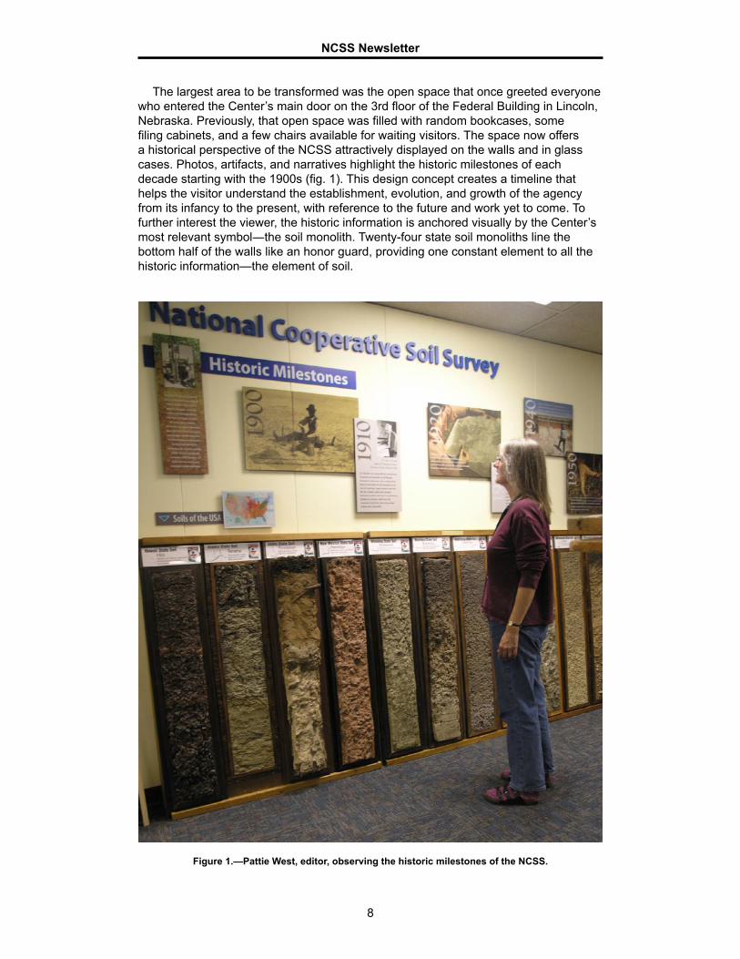
The largest area to be transformed was the open space that once greeted everyone who entered the Center’s main door on the 3rd floor of the Federal Building in Lincoln, Nebraska. Previously, that open space was filled with random bookcases, some filing cabinets, and a few chairs available for waiting visitors. The space now offers a historical perspective of the NCSS attractively displayed on the walls and in glass cases. Photos, artifacts, and narratives highlight the historic milestones of each decade starting with the 1900s (fig. 1). This design concept creates a timeline that helps the visitor understand the establishment, evolution, and growth of the agency from its infancy to the present, with reference to the future and work yet to come. To further interest the viewer, the historic information is anchored visually by the Center’s most relevant symbol―the soil monolith. Twenty-four state soil monoliths line the bottom half of the walls like an honor guard, providing one constant element to all the historic information—the element of soil.
Figure 1.—Pattie West, editor, observing the historic milestones of the NCSS.

�
NCSS Newsletter
To further improve and inform, the Center’s five divisions are prominently displayed on the main entrance wall. Each division is listed by name and a photo that illustrates its work, along with a short narrative explaining the division’s mission. Anyone visiting for the first time will know what the Center does by seeing or reading what appears on the entrance wall. Also, the Center incorporated “official” signage that tells anyone looking for the Center’s offices exactly which door to enter. Before the new signage, visitors or new employees would find themselves wandering the halls looking for the National Soil Survey Center. Now the name is proudly displayed along with the agency name and logo directly adjacent to the main entry door.
The historical perspective and office signage are not the only improvements. Art also has an important place with the creation of an art-gallery type of display devoted to famous Lewis and Clark soil paintings (fig. 2). Jan Lang, a Center employee, created the paintings using soil as the base element for her paints. This gives the paintings a very special look and feel that brought national attention to both her and the paintings.
Figure 2.—Viewing Jan Lang’s soil paintings. Note mural of a desert soil at the left.
10
NCSS Newsletter
Jan Lang also painted three murals, one on each of the office’s main structural columns. Each mural depicts a different area of the country―the East with a focus on forest soils, the Heartland with a focus on agricultural soils, and the West with a focus on desert soils (fig. 2).
The Center’s Research and Laboratory Divisions, located on the 4th floor, received the same special attention. Their main entrance had similar signage installed, including the agency name and logo and displaying the various divisions within Laboratory and Research. The division names were accompanied by an appropriate photo and a short narrative indicating the division’s mission.
While a lot of changes have been made, the effort continues to be a work in progress. The final goal is that the Center not only will be an outstanding workplace, but also will become a destination for visitors, schools, science classes, and others interested in learning more about the Center, NRCS, soil, and the valuable work being done on a daily basis at the NSSC.
Spanish Version of 11th Edition of Keys to Soil Taxonomy Now Available
Submitted by Pattie West, Editor, NRCS, National Soil Survey Center, Lincoln, Nebraska.
The 11th edition of Keys to Soil Taxonomy is now available in Spanish. The publication can be accessed
at http://soils.usda.gov/technical/classification/tax_keys/. The translation will expand the horizons of U.S. Soil Taxonomy by allowing professionals in all parts of the world to apply and interpret the system in a more uniform and consistent way. While soils differ globally, the ability to apply a system that is universally understood and accepted is a goal shared by many soil scientists. As the world struggles with global warming and other environmental challenges, having a universally accepted method that can be applied when soil problems are addressed will contribute to successful outcomes.
In addition to the online PDF file, the publication will be available on a CD and can be requested by contacting the National Soil Survey Center in Lincoln, Nebraska. A limited number of hard copies will be printed and available by late winter through the NRCS Distribution Center. Information about ordering these hard copies is available at http://soils.usda.gov/technical/classification/tax_keys/).
Soil Survey Scanning Projects: A Status ReportBy Stanley P. Anderson, Editor, NRCS, National Soil Survey Center, Lincoln, Nebraska.
The National Soil Survey Center (NSSC) in Lincoln, Nebraska, is working on two soil survey scanning projects, one for surveys printed in the period 1899
through 1958 and the other for surveys printed after 1958. Surveys that have been scanned and posted to the Web are identified in the “List of Soil Surveys by State” (http://soils.usda.gov/survey/printed_surveys/). If you have questions about the status of these or other surveys, contact Pattie West, editor at the National Soil Survey Center (402-437-5334; [email protected]).

11
NCSS Newsletter
1899-1958 SurveysNearly all of these surveys are being scanned and assembled at the National
Cartography and Geospatial Center in Fort Worth, Texas, and reviewed by editors and posted to the Web. Some are scanned and assembled at the NSSC or at selected MO Offices. The testing phase of this project started in the spring of 2008; production started in May 2009.
A list of about 1,800 of these old surveys has been developed. About 580 (32%) of these have been posted to the Web in the 2.5 years since production started. That is a rate of about 230 surveys per year. There are about 1,220 (68%) surveys yet to be scanned, assembled, and posted. If we continue to work at a rate of 230 surveys per year, the remaining workload should be done in about 5.3 years.
Surveys Printed After 1958 Nearly all of these surveys have been scanned by a contractor in Omaha. The first
surveys were sent to the contractor in November 2006 (5 years ago). Of the 2,010 surveys in this project, about 350 (17%) are being scanned, 840 (42%) have been scanned but are not yet processed, and 820 (41%) have been posted to the Web.
In the last 5 years, the contractor sent the scanned images to the Geospatial Research Unit in Morgantown, West Virginia, where the files were assembled. The assembled files were then sent to the NSSC, where they were reviewed by editors and then posted to the Web. From now on, however, all follow-through work, including assembly and review of scanned files and posting of the scanned surveys to the Web, is being done at the NSSC.
Retirement of Marc Crouch
Marc Crouch’s last day after 39 plus years with NRCS is December
2. Marc started out as a soil scientist in Middlesex County, CT, and mapped soils in several CT counties, eventually becoming the project leader responsible for New London County. From there, he went to Ohio as the Area Soil Scientist in the Medina Area Office serving northeast Ohio. This was the first position Ohio dedicated to what is now referred to as Technical Soil Services. An opportunity to travel internationally took Marc and his family to Riyadh, Saudi Arabia, for 3 years, where he was part of a team completing the General Soil Map of the Kingdom of Saudi Arabia. Returning to the states in 1986, he joined the state soil staff in Richmond, VA, where he was an assistant state soil scientist until the 1995 reorganization. From 1995 until 2005, he was a soil data quality specialist assigned to Raleigh and MO14, maintaining his home in Richmond. During his time in Virginia and assignment to MO14, he traveled on TDY for NRCS to Indonesia and Kuwait and began a tenure as an instructor for the Soil Correlation course for the Soil Survey Division (SSD). Though having vowed to never again live north of the Mason-Dixon Line, in 2005 he took the opportunity to go to the National Soil Survey Center in Lincoln, NE, as the training coordinator for the SSD. In the 6
Jon Hempel presents Marc with a certificate signed by the Chief.

12
NCSS Newsletter
years there, he helped the SSD move from the delivery of 8 courses to the delivery of 17 courses and a large library of training information maintained on the soils.usda.gov Web site.
Marc and his wife Marie, whom he met in CT one night while attending an SCS all employee’s meeting (the circumstances will not be discussed here), will reside in Leesburg, FL. He told Marie that after she had followed him around the world all these years that she could pick the next location. (They enjoyed Lincoln, but the winters!) Marc’s plans include golf, softball, officiating basketball, possibly contract delivery of training with NEDC and other part-time opportunities, as well as volunteer work.
Marc envisions his future.
Stan Anderson RetiresBy Stanley P. Anderson, Editor, NRCS, National Soil Survey Center, Lincoln, Nebraska.
After more than 37 years of Federal service in SCS and NRCS, l have decided to retire as of December 30, 2011. I began my Federal career in 1974, when I
joined the Soil Survey Editorial Staff in Hyattsville, Maryland. In 1976, I was transferred to the Midwest Technical Service Center in Lincoln, Nebraska. I have remained in Lincoln to the present day, despite a baffling series of reorganizations. These included consolidation of all soil survey editors in Maryland; dispersal of the editors to the four TSCs (or NTCs) in Portland, Ft. Worth, West Chester, and Lincoln; consolidation of the editors in Lincoln; and dispersal of the editors to various MO offices. I do not expect to be around for the next consolidation.
I earned a B.A. degree in English at the University of Minnesota in Duluth and M.A. and Ph.D. degrees in English at the University of Maryland. I have been married to Janet Shell Anderson, a retired lawyer, since 1968. We have three sons—Robert, Michael, and Joseph, our best productions.
I will spend my time in retirement writing, editing, reading, swimming, and traveling around the country. Janet and I have both published poetry and short fiction, mainly online. For online examples, Google Janet Shell Anderson or Stanley P. Anderson. We hope that this publishing activity will continue into the future.
My experience on the Soil Survey Editorial Staff from 1974 to 1976 taught me the ins and outs of editing. Thelma Finlay, my supervisor, was an excellent grammarian, a talented editor, and a hard taskmaster. She taught me a few things about grammar I did not know when I walked in the door and showed me that imagination is needed in editing what she called “sticky passages” of text. To meet her demands, you had to imagine the clauses of a “sticky” complex sentence in a different order or expressed in different key words, all without changing the author’s intended meaning. As teacher of undergraduate English courses, I had experience identifying editorial errors, but I found that editing a technical document is much more demanding because it requires that you correct all of the errors that you identify. By the end of the first week, I was exhausted by the effort, so much so that Thelma gave me a light reading assignment to finish off Friday afternoon.
My first years at the TSC in Lincoln taught me the value of a thorough knowledge of the content of soil surveys. I learned much from Roy Smith, the manuscript reviewer at the Midwest Technical Service Center. Roy and I created the “Stan and Roy Show,” which we took to the Midwest States in an attempt to give quidance on how to write soil survey reports. Roy was 80 percent of the show. He gave effective presentations

13
NCSS Newsletter
on the various parts of the reports. I could tell that he had been a teacher and a good one. I was 20 percent of the show. Knowing that I could not possibly teach party leaders all they needed to be good writers, I resorted to humor, as if I were Red Skelton or some other comedian. I provided comic relief along with a little bit of instruction. I developed a list of sentences entitled “My Favorite Obscenities and Absurdities,” which I used to entertain the troops. I dare not quote many of these sentences here, but following are a few of the milder ones:
This soil is in trees. A cover crop helps to prevent wind blowing. Parshall soils formed in glacial outwash or wind deposits. Few to many mottles are common. Buildings with basements should be avoided. The water table is at a depth of no more than at least 3 feet.
So, my first 4 years with SCS taught me how to be an editor, to be free to use my imagination when it was needed and yet to be faithful to the author’s intended meaning. I say “intended meaning” because so much of the time the writer says something close to what he or she means but misses the mark, claiming that a cover crop can prevent wind blowing or that a given soil formed in deposits of wind.
In a recent email, Kit Paris asked me to include a collection of my writings over the years in the last NCSS Newsletter that I will edit (issue 57). He thought that the last issue “sure would be a great place to put the famous quips and articles.” I have decided to make a separate file of those writings. This file, called “Stan Stuff,” is available at http://soils.usda.gov/partnerships/ncss/newsletters.html.
After all these years of practicing my craft, it is time for me to say farewell. I thank all of the people who contributed to this newsletter over the years and all of the soil scientists who were willing to help me when I was puzzled by a “sticky passage,” such as the last of my examples of absurdities. And so, without further ado, adieux. Goodbye and God bless.
Time To Move On!By Jim R. Fortner, Soil Scientist, NRCS, National
Soil Survey Center, Lincoln, Nebraska.
After 39+ years with SCS and NRCS, I have decided that it is time to
move on to the next phase of my life. I plan to retire effective December 30, 2011. It has been a great ride, but there comes a time to move on. I would never have dreamed, when I first walked into the field/soil survey office in Allen County, Kansas, back in 1972, that my career would have taken me where it has—6 locations in Kansas and Missouri during the first 18 years, and the last 21 here at the National Soil Survey Center.
Along the way I have worked with a lot of great people, both within and outside the agency. I consider many of you friends. A lot has changed within NRCS and the soil survey program during the past 39 years, but one thing remains constant—we have a lot of talented and skilled employees who care about the soil resource.
Plans for the future are somewhat uncertain at this point. Pegi and I plan to remain here in Lincoln for the time being. Besides the obligatory honey-do list, I plan to find
Jim Fortner

�4
The U.S. Department of Agriculture (USDA) prohibits discrimination in all its programs and activities on the basis of race, color, national origin, age, disability, and where applicable, sex, marital status, familial status, parental status, religion, sexual orientation, genetic information, political beliefs, reprisal, or because all or a part of an individual’s income is derived from any public assistance program. (Not all prohibited bases apply to all programs.) Persons with disabilities who require alternative means for communication of program information (Braille, large print, audiotape, etc.) should contact USDA’s TARGET Center at (202) 720-2600 (voice and TDD). To file a complaint of discrimination write to USDA, Director, Office of Civil Rights, 1400 Independence Avenue, S.W., Washington, D.C. 20250-94�0 or call (�00) 795-3272 (voice) or (202) 720-63�2 (TDD). USDA is an equal opportunity provider and employer.
NCSS Newsletter
more time to fish, hunt, golf, travel some, spend time with the grandkids, garden, and “yes” I might even find time to do a little contract work through ACES.
I wish you all the best as you move the soil survey program forward. If you have occasion to contact me, and I hope you do, I can be reached at the following address and email:
��000 Rocky Ridge Rd.Lincoln, NE 6�526402-4�6-�6�5Email: jf4�54�@windstream.net
Happy Trails!
Douglas Helms RetiresBy Douglas Helms, National Historian, Ecological Sciences Division, NRCS, Washington, D.C.
On December 3�, 20��, I will take my leave as historian of the Soil Conservation Service and Natural Resources Conservation Service. It has been a privilege,
and dare I say, a pleasure to have worked in this capacity. Just as you used your training in soil science to contribute to the mission of the agency, I have tried to use my training in history to do the same.
One of the pleasures of working in SCS and NRCS has been meeting and learning from the soil scientists. Since I did not take any university courses in soil science, you were my teachers. Many times in conversations, one of you would mention a fact about soils and I would have one of those moments, figuratively slapping my palm against my forehead, and thinking, “Of course. That explains it.”
To recall just one example, the late Don McCormick taught a soil science course in the USDA Graduate School, which I took in �9�5. His demonstration of ribboning clay was impressive, but his statement that soils with high silt content had the feel of talcum powder evoked a childhood memory. Then I remembered playing barefoot in Union County, North Carolina, where the silt of the slate belt soils had that dry, powdery feel. Other epiphanies involved learning facts about soil properties from you and then realizing their significances in some historical development.
I hope our paths continue to cross and that you and I have occasions to call one another.