Embed Size (px)
Citation preview
International Journal of Innovative Research in Advanced Engineering (IJIRAE) ISSN: 2349-2163 Issue 03, Volume 4 (March 2017) www.ijirae.com
_____________________________________________________________________________________________________ IJIRAE: Impact Factor Value – SJIF: Innospace, Morocco (2016): 3.916 | PIF: 2.469 | Jour Info: 4.085 |
ISRAJIF (2016): 3.715 © 2014- 17, IJIRAE- All Rights Reserved Page -41
NAVIGATION ALERT SYSTEM FOR FISHERMEN WITH SOLAR POWER HARVESTING
Nandhitha.B Mrs.C.Padmavathy, Priya Dharshini.U IV Information Technology Assistant Professor (Sl.Gr) / IT Dept, IV Information Technology Sri Ramakrishna Engineering College Sri Ramakrishna Engineering College Sri Ramakrishna Engineering College Coimbatore, India Coimbatore, India Coimbatore, India
Mohana Priya .M Nivedha .R IV Information Technology IV Information Technology Sri Ramakrishna Engineering College Sri Ramakrishna Engineering College Coimbatore, India Coimbatore, India
Abstract - Peril faced by the fishermen, who are caught by navy for breaching the border has increased. In spite of latest development in the technology hardly any action to neutralize the terror has taken place. The border between the countries in the sea level is not very easy to identify and this causes problems. The Tamil Nadu fishermen even today summon the historical rights and routinely go astray into the International Maritime Boundary Line (IMBL) for fishing. This has led to trepidation by the Sri Lankan Navy and in some cases even to shoot or arrest the particular fishermen. This leads to loss in the both humans as well as their economic incomes. The fishermen mainly cross the border as they are unaware of their limits in the maritime border. If the fishermen become conscious of their current location with the alertness of boundary limits then they will not willingly put themselves in danger by passing the line of control. In order to make it easy for the fishermen to recognize the border this system is developed. Using Global Positioning System (GPS) the current location of the fishermen’s boat is calculated and then it is compared with official boundary values. In case the fisherman nears the boundary an alarm warns him and if he persuades further a message is sent to coastal control about the breach along with the boat ID.To make the system more efficient energy is derived from sun using solar panel and converted into electrical energy and applied to the system.
Keyword - GSM, GPS, microcontroller, navigation, boat, fishermen
I. INTRODUCTION
The border between the countries in sea is not as easy to identify as it is with land. This often leads to perplexity among fishermen. Fishermen are left wondering about the legitimate area to pursue fishing within their country’s boundary without getting into danger. Navy, time and again, remain clueless about the activities of its native fishermen as it is difficult to keep watch on everyone every time. Conflicts arise between countries owing to the violation of the fishermen and more than often fishermen end up captured. The family of the victims also suffer because of the uncertainty of the plight of their own people. Increasing tensions across the Indian and Sri Lankan borders caused much havoc between the two countries. Fishermen from our country are being abducted by the Sri Lank navy for crossing the border. There have been more than 1752 occasion of Indian fishermen vanishing near Palk-straits.
Recently on 08 February, 2017 Times of India published,” Lankan Navy apprehends 10 Indian fishermen” India and Sri Lanka signed two treaties in 1974 and 1976 respectively to acknowledge their maritime boundaries. The treaties mainly focussed on the mark of legitimate entry of both the countries with respect to Gulf of Mannar and Bay of Bengal. Irrespective of this the tug between the countries’ fishermen and navy prevailed in the maritime disclosed to the eyes of other inhabitants. The uncertainty in understanding the boundary has prevailed over a couple of decades now.
International Journal of Innovative Research in Advanced Engineering (IJIRAE) ISSN: 2349-2163 Issue 03, Volume 4 (March 2017) www.ijirae.com
_____________________________________________________________________________________________________ IJIRAE: Impact Factor Value – SJIF: Innospace, Morocco (2016): 3.916 | PIF: 2.469 | Jour Info: 4.085 |
ISRAJIF (2016): 3.715 © 2014- 17, IJIRAE- All Rights Reserved Page -42
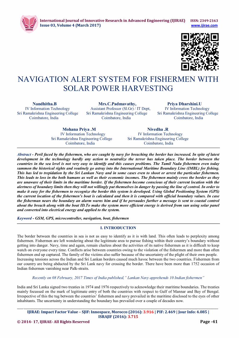
NO. OF INDIAN ANGLERS ARRESTED
1000
800
600 787
400
454
No. Of Indian anglers Arrested 200
248
197 222 Source: www.mea.gov.in/rajyasabha.html 0 2012 2013 2014 2015 2016
Fig 1: Survey graph
II. EXISTING SYSTEM
Commercial vessels and cargos are often tracked using GPS. Moreover they are provided with legal paper works to enter the boundary of the nearest country. This makes their entry all more legal to any country and they are considered as an asset to economy rather than violators of boundary. The owners of the commercial freight are aware of the location at point of time and the exact time of arrival in port. Most of the commercial freights are departed in bulk and since huge sum is involved the owners always make an attempt to be sure of the safety of their goods and equip the same with all required gadgets to track them. However fishermen are oblivious to such benefits and often end up in maelstrom. Certain higher end tracking devices for boats that is effective to track in middle of water body comes with huge price and fishermen fail to afford them. Even if the tracking is made possible with additional effort, navy is often left wondering who leaves the border intentionally. Fishermen tend to take advantage of this oblivious state of the navy. Any changes that can bring about changes regarding the safety of fishermen while including navy in understanding the regular actions of the fishermen is fruitful. It can save lives of many and also the pride of a nation and its fishermen.
III. PROPOSED SYSTEM
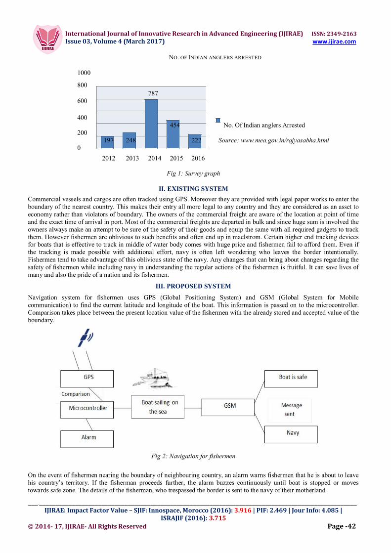
Navigation system for fishermen uses GPS (Global Positioning System) and GSM (Global System for Mobile communication) to find the current latitude and longitude of the boat. This information is passed on to the microcontroller. Comparison takes place between the present location value of the fishermen with the already stored and accepted value of the boundary.
Fig 2: Navigation for fishermen
On the event of fishermen nearing the boundary of neighbouring country, an alarm warns fishermen that he is about to leave his country’s territory. If the fisherman proceeds further, the alarm buzzes continuously until boat is stopped or moves towards safe zone. The details of the fisherman, who trespassed the border is sent to the navy of their motherland.
International Journal of Innovative Research in Advanced Engineering (IJIRAE) ISSN: 2349-2163 Issue 03, Volume 4 (March 2017) www.ijirae.com
_____________________________________________________________________________________________________ IJIRAE: Impact Factor Value – SJIF: Innospace, Morocco (2016): 3.916 | PIF: 2.469 | Jour Info: 4.085 |
ISRAJIF (2016): 3.715 © 2014- 17, IJIRAE- All Rights Reserved Page -43
The navy officer can do the needful to secure the fishermen and also provide requisite warning to dissuade them from repeating the same. Basically the project requires 5V power supply. To conserve energy and to provide uninterrupted power supply especially in middle of the sea, energy derived from natural resources is used. The natural resources that are prominently helpful for this purpose are solar, hydro, wind, etc. Considering that these resources are easily available in the sea, this technique can be effective. In this system energy is derived from sun. The energy generated by the medium is stored in capacitor and it is used to charge the battery incessantly. This way the there is no fear of the system stop working in the middle of the water.
IV. COMPONENTS
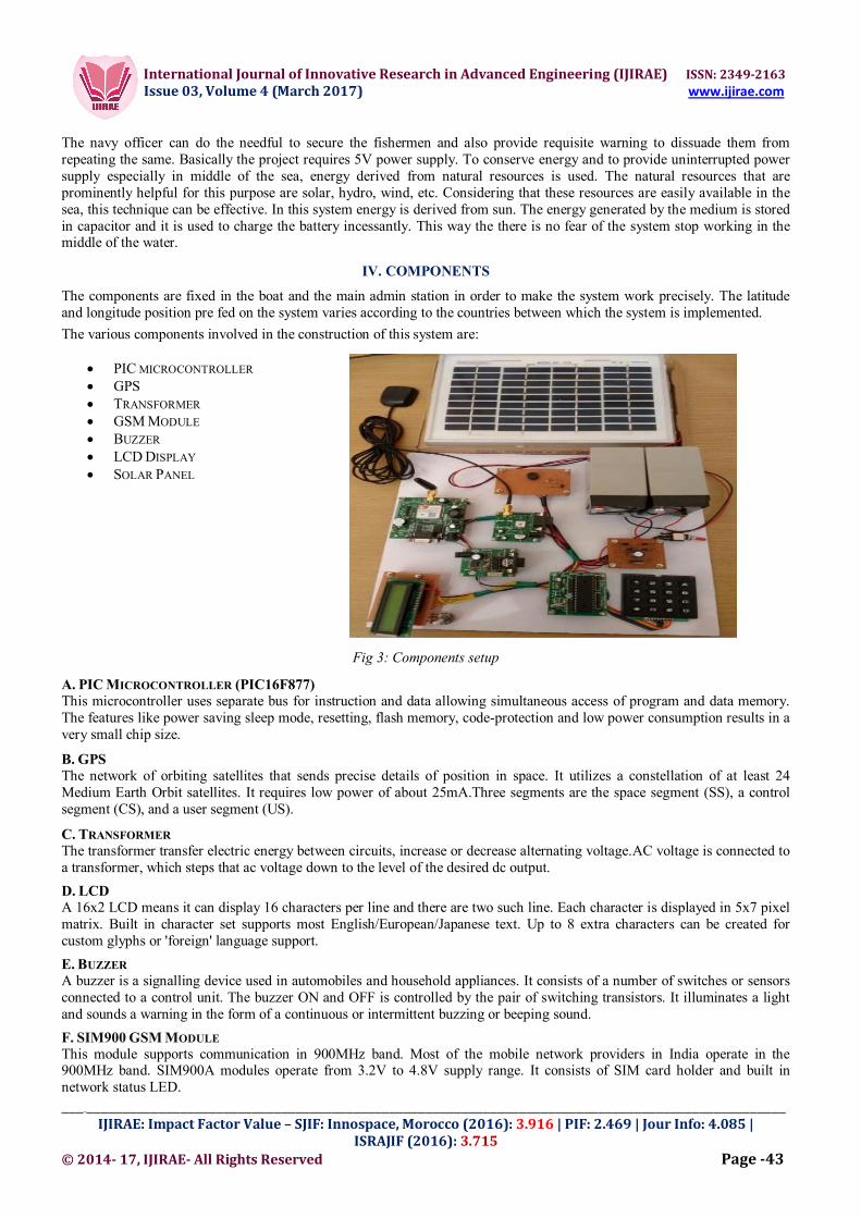
The components are fixed in the boat and the main admin station in order to make the system work precisely. The latitude and longitude position pre fed on the system varies according to the countries between which the system is implemented.
The various components involved in the construction of this system are:
PIC MICROCONTROLLER GPS TRANSFORMER GSM MODULE BUZZER LCD DISPLAY SOLAR PANEL
Fig 3: Components setup
A. PIC MICROCONTROLLER (PIC16F877) This microcontroller uses separate bus for instruction and data allowing simultaneous access of program and data memory. The features like power saving sleep mode, resetting, flash memory, code-protection and low power consumption results in a very small chip size.
B. GPS The network of orbiting satellites that sends precise details of position in space. It utilizes a constellation of at least 24 Medium Earth Orbit satellites. It requires low power of about 25mA.Three segments are the space segment (SS), a control segment (CS), and a user segment (US).
C. TRANSFORMER The transformer transfer electric energy between circuits, increase or decrease alternating voltage.AC voltage is connected to a transformer, which steps that ac voltage down to the level of the desired dc output.
D. LCD A 16x2 LCD means it can display 16 characters per line and there are two such line. Each character is displayed in 5x7 pixel matrix. Built in character set supports most English/European/Japanese text. Up to 8 extra characters can be created for custom glyphs or 'foreign' language support.
E. BUZZER A buzzer is a signalling device used in automobiles and household appliances. It consists of a number of switches or sensors connected to a control unit. The buzzer ON and OFF is controlled by the pair of switching transistors. It illuminates a light and sounds a warning in the form of a continuous or intermittent buzzing or beeping sound.
F. SIM900 GSM MODULE This module supports communication in 900MHz band. Most of the mobile network providers in India operate in the 900MHz band. SIM900A modules operate from 3.2V to 4.8V supply range. It consists of SIM card holder and built in network status LED.
International Journal of Innovative Research in Advanced Engineering (IJIRAE) ISSN: 2349-2163 Issue 03, Volume 4 (March 2017) www.ijirae.com
_____________________________________________________________________________________________________ IJIRAE: Impact Factor Value – SJIF: Innospace, Morocco (2016): 3.916 | PIF: 2.469 | Jour Info: 4.085 |
ISRAJIF (2016): 3.715 © 2014- 17, IJIRAE- All Rights Reserved Page -44
G. SOLAR PANEL It is a device used to convert light into electricity by photovoltaic effect. Light is observed charges are separated and electric energy is derived.
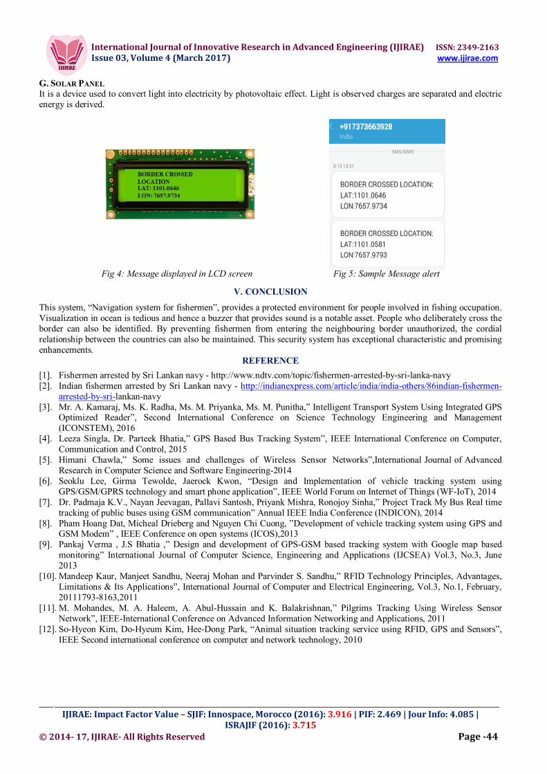
Fig 4: Message displayed in LCD screen Fig 5: Sample Message alert
V. CONCLUSION
This system, “Navigation system for fishermen”, provides a protected environment for people involved in fishing occupation. Visualization in ocean is tedious and hence a buzzer that provides sound is a notable asset. People who deliberately cross the border can also be identified. By preventing fishermen from entering the neighbouring border unauthorized, the cordial relationship between the countries can also be maintained. This security system has exceptional characteristic and promising enhancements.
REFERENCE
[1]. Fishermen arrested by Sri Lankan navy - http://www.ndtv.com/topic/fishermen-arrested-by-sri-lanka-navy [2]. Indian fishermen arrested by Sri Lankan navy - http://indianexpress.com/article/india/india-others/86indian-fishermen-
arrested-by-sri-lankan-navy [3]. Mr. A. Kamaraj, Ms. K. Radha, Ms. M. Priyanka, Ms. M. Punitha,” Intelligent Transport System Using Integrated GPS
Optimized Reader”, Second International Conference on Science Technology Engineering and Management (ICONSTEM), 2016
[4]. Leeza Singla, Dr. Parteek Bhatia,” GPS Based Bus Tracking System”, IEEE International Conference on Computer, Communication and Control, 2015
[5]. Himani Chawla,” Some issues and challenges of Wireless Sensor Networks”,International Journal of Advanced Research in Computer Science and Software Engineering-2014
[6]. Seoklu Lee, Girma Tewolde, Jaerock Kwon, “Design and Implementation of vehicle tracking system using GPS/GSM/GPRS technology and smart phone application”, IEEE World Forum on Internet of Things (WF-IoT), 2014
[7]. Dr. Padmaja K.V., Nayan Jeevagan, Pallavi Santosh, Priyank Mishra, Ronojoy Sinha,” Project Track My Bus Real time tracking of public buses using GSM communication” Annual IEEE India Conference (INDICON), 2014
[8]. Pham Hoang Dat, Micheal Drieberg and Nguyen Chi Cuong, ”Development of vehicle tracking system using GPS and GSM Modem” , IEEE Conference on open systems (ICOS),2013
[9]. Pankaj Verma , J.S Bhatia ,” Design and development of GPS-GSM based tracking system with Google map based monitoring” International Journal of Computer Science, Engineering and Applications (IJCSEA) Vol.3, No.3, June 2013
[10]. Mandeep Kaur, Manjeet Sandhu, Neeraj Mohan and Parvinder S. Sandhu,” RFID Technology Principles, Advantages, Limitations & Its Applications”, International Journal of Computer and Electrical Engineering, Vol.3, No.1, February, 20111793-8163,2011
[11]. M. Mohandes, M. A. Haleem, A. Abul-Hussain and K. Balakrishnan,” Pilgrims Tracking Using Wireless Sensor Network”, IEEE-International Conference on Advanced Information Networking and Applications, 2011
[12]. So-Hyeon Kim, Do-Hyeum Kim, Hee-Dong Park, “Animal situation tracking service using RFID, GPS and Sensors”, IEEE Second international conference on computer and network technology, 2010

International Journal of Innovative Research in Advanced Engineering (IJIRAE) ISSN: 2349-2163 Issue 03, Volume 4 (March 2017) www.ijirae.com
_____________________________________________________________________________________________________ IJIRAE: Impact Factor Value – SJIF: Innospace, Morocco (2016): 3.916 | PIF: 2.469 | Jour Info: 4.085 |
ISRAJIF (2016): 3.715 © 2014- 17, IJIRAE- All Rights Reserved Page -45
AUTHOR’S PROFILE
Nandhitha.B is a final year student pursuing B.Tech Information Technology in Sri Ramakrishna Engineering College. Her area of interest is networking.
Mrs. C.Padmavathy is currently working as Assistant Professor (Selection Grade) in the Department of Information Technology in Sri Ramakrishna Engineering College. Currently she is pursuing PhD in Anna University .She has 13 years of teaching experience. Her areas of interest are wireless sensor networks, Data structures, mobile computing and Compiler design. She has guided more than 20 UG projects and 10 PG projects. She had published four papers in International journals, presented nine papers in National and International journals. She is an active member in various Professional bodies .
Priya Dharshini.U is a final year student pursuing B.Tech Information Technology in Sri Ramakrishna Engineering College. Her area of interest is networking.
Mohana Priya.M is a final year student pursuing B.Tech Information Technology in Sri Ramakrishna Engineering College. Her area of interest is network communications.
Nivedha.R is a final year student pursuing B.Tech Information Technology in Sri Ramakrishna Engineering College. Her area of interest is embedded systems.