Embed Size (px)
Citation preview

COSUMNES RIVER
NAVIGABILITY STUDY
FEBRUARY 1991
PREPARED BY THE STAFF OF THE CALIFORNIA ST A TE LANDS COMMISSION
w 24509
\~I
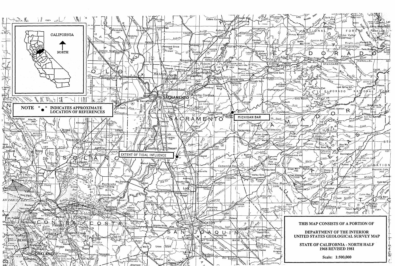
CALIFORNIA
t NORTH
NOTE " " •
AN
THIS MAP CONSISTS OF A PORTION OF
DEPARTMENT OF THE INTERIOR UNITED STATES GEOLOGICAL SURVEY l\1AP
STATE OF CALIFORNIA - NORTH HALF 1968 REVISED 1981
Scale: 1:500,000
1ST.
r: \ I

1 tl'P4 •
L· l t- -, ·i 'r.1 , • ,.,.'t J. ~-"'
\
CALIFORNIA
t NORTH
STATE OF CALIFORI\11A; 1968; EDITION OF 1971
'f:c E,_DUl • I \
'

~ I - '
2 I 1[ "-.......~
·!! •• : "s..._______ __ If D ----_
-~--- "-,\ ~~··~:~:'::::Y ••
0:c-~--
7~ r~~--
: (THORNTON) I 1760 Ill NW
~r.AI r- 1 · ?11 r,i'\()
15
+ 16 TWIN ··-·--
DITCH
I __ :: )
cwell[ . -- 17" I /o] II . "
I: II '
. I
ROA Di
• !NTER!OR--GEOLO .1c.a..1 C..LJRVE_Y, RE<;TON, VIRGJNIA--19ee
64JOOOm [.
,21
I I I I I I I I I I I I I
~I~ o::lo::
I I I
Well 24
I ~
I\
\' ---23
•• y.

0 .. -,
II II II II II II II
di
D
Well '2a
~JI~ Q • Q •
"'
-~.
::: r---,1: L~-·- J''
/
\..//
I
u11 =-·:f'-··-.. --~~ ~· .
2
26
II Well£:P
25 II II II II II II
[
;-::;;:;:~~.: ,,,,, .. ::::~::.~(-:::·;;"""" ··-~··.
II 11 ,,
25~
1··-1 Well i 19° I j
J l I
i''"'"'"""""'' II II II II II
:~1 11 I ~·I\ II ·o~-- '\
,, ,, ,, \\ \\
31 ,, ;X
(,
Well ~I

,\ j'
I I I
I
M
Well 1
.a;· 0
-; I
c H
\I II II I\ ii \\
II
-.5
u
, ..
M
'/
·,39 I,' ', '
, \';) '-;.o
I J,1
i
42
'(If y I / (
(,lJ
r,1
• I
,1
" I 54
I i


/
I /,
5 II II II
l_.J 11 O II
\" 'rt / )/ .
:T1- ._-\I
I ~' 1\ \ I
/


(

COSUMNES RIVER NAVIGABILITY STUDY
PREPARED BY THE STAFF OF THE
CALIFORNIA STATE LANDS COMMISSION
W24509
PREPARED FEBRUARY, 1991 Cover Design by Ruth Odlin

CONTENTS
CHAPTER PAGE
I Introduction 1
II Summary of Findings 2
III General Description of the Cosumnes River 5
N Navigability Defined 6
Act of Admission 10
v Cosumnes River- Declarations of Navigability 11
VI Historical Summary 12
VII Recreational Activities 14
VIII Chronological Summary of Events 17
IX Public Land and Private Grant Surveys 28
x Swamp and Overflowed Lands -Surveys and Locations 30
XI County Boundaries 31
XII Reports of the Chief of Engineers 32
XIII Cosumnes River Flow Data at Michigan Bar 34

CONTENTS cont.
SECTION PAGE
XIV Reference Maps Showing River Miles 35
xv Summary of Maps 49
XVI List of Miscellaneous Maps 50
XVII List of U.S. Geological Survey
Topographic Maps (Quads) 53
xvm Additional Research Sources 56
XIX Bibliography 57
xx Sources 63
MAPS
Portions of Department of the Interior, U.S. Geological Survey Maps:
State of California 1: 1,000,000
State of California North Half 1:500,000
Sacramento California 1 :250,000

CHAPTER I
INTRODUCTION
This navigability study of the Cosumnes River is a result of the increased
attention in the State's sovereign interest in the rivers throughout California.
State sovereign interest exists in many of these waterways and consists of:
1. Fee title between the Ordinary High Water Marks in areas subject to the tides; and
2. Fee title between the Ordinary Low Water Marks in navigable, non-tidal areas.
In addition, the Public Trust Easement exists between the Ordinary High
and Low Water Marks in navigable, non-tidal waterways.
The last natural course of the waterway defines the location of this sovereign interest.
The purpose of this report was to collect data and analyze evidence to help
determine the extent of navigability on the Cosumnes River; enabling us to more clearly establish sovereign interest. Specifically, this report addresses
how much of the river is and was navigable. The determination of the last natural location of the river and public use easements were not included in
this study.
Although our research was extensive, obviously all sources were not exhausted and further findings may change the conclusions drawn in this
report.
Page 1

CHAPTER II
SUMMARY OF FINDINGS
California's sovereign interest exists in that portion of the Cosumnes River subject to the tides and lying between the Ordinary High Water Marks. According to the United States Army, Corps of Engineers, tidal influence exists at a point approximately 3.5 miles upstream from its mouth.
California's sovereign interest also exists in that portion of the river that is non-tidal and navigable in its last natural location. The following evidence supports historical navigability:
Three ranchos exist along the Cosumnes River in Townships 6 and 7 North,
Range 6 East and Township 7 North, Range 6 East, Mount Diablo Meridian. The left bank of the river was meandered in Ranchos Sanjon de
los Moquelumnes and Cosumnes. Rancho Omochumnes lies northwesterly of these ranchos and on the opposite side of the river. Here, the surveyor meandered the right bank. That portion which lies northwesterly of Rancho Sanjon de los Moquelumnes and not within Rancho Omochumnes (Section
29, T6N, R6E, MDM) lies within Swamp and Overflowed Land Survey 609, which also meandered the river. Therefore, the bed of the Cosumnes
River was excluded from private ownership within the area from the west line of Section 29, T6N, R6E, MDM to the northeast comer of Rancho
Omochumnes which lies within Section 1, TIN, R7E, MDM.
In addition, incidental evidence exists. Dayler's Ferry operated across the Cosumnes River in 1853 at the present site of Sloughhouse. Also,
according to testimony included in the proceedings of State of California
Page2

v. United States (within the area included in S & 0 609) N. W. Coons navigated the swamplands just downstream of the Highway 9-9 I 50 bridge
in 1868.
Presently, portions of the Cosumnes River are navigable and used for recreational purposes. The river between its mouth to a point about eight
miles above Latrobe Road Bridge can be navigated with open canoes and rafts for seven months between December through June. The remaining
months have either flows that are too low or no flows at all. Two portages are necessary within this area: Granlees Dam and below Latrobe Road
Bridge. A more difficult level of boating exists above this portion to Highway 49.
The North Fork of the river between its junction with the main river
upstream for four miles can be navigated at times. The Middle Fork of the river from its junction at the North Fork and main channel can be navigated
for approximately three miles. Above this point it is extremely difficult and many portages are needed. There is no use of the _South Fork for
recreational purposes.
In 1975 Sacramento County Counsel Clement J. Dougherty, Jr. determined that the Cosumnes River was capable of being navigated from Michigan Bar
to the point where it joins the Mokelumne River. This determination was the result of a request from the Sacramento County Community Development
and Environmental Protection Agency to determine whether the Cosumnes River is navigable.
The public land surveys offer little evidence of navigability. The earliest
instructions for the survey of public lands referring to non-navigable waterways was in 1864. These instructions stated that " Rivers not
embraced in the class denominated "navigable" under the statute, but which are well defined natural arteries of internal communication and have a
Page3

uniform width, will only be meandered on one bank." This was usually the
right bank. The manual of 1881 instructed the same. The manual of 1871 was a reprint of the 1855 manual and, as such, did not address this issue.
The survey for T5N, R5E, MDM (May 23, 1870) meanders the right bank
of the river in Section 2. The survey for TIN, R7E, MDM (June 23, 1871) meanders the left bank in only a small portion of Section 1, probably to tie
the public lands to the ranchos. The various surveys for TIN, R8E, MDM meander the south bank of the river. The surveys for the remainder of the
townships including the Cosumnes River do not meander the river and
therefore did not segregate it from the public lands. In essence, only small
portions of the river were meandered and only on one side as the surveyor was instructed to do for non-navigable waterways.
The Harbors and Navigation Code does not include the Cosumnes River,
however, as noted in chapter 4 the court held in People v. Mack (19 CA 3d 1040) that "the failure of the Legislature to designate Fall River in the list of
navigable waters in the Harbors and Navigation Code sections 101 - 106, is --
of no consequence."
The United States Army, Corps of Engineers does not include the
Cosumnes River in its list of navigable waterways either.
Page4

CHAPTER III
GENERAL DESCRIPTION
OF THE COSUMNES RIVER
The 580 square mile basin drained by the Cosumnes River lies on the
western slope of the Sierra Nevada. The Cosumnes River lies between the
American River to the north and the Mokelumne River to the south.
Beginning in El Dorado County the main channel, or south fork of the river,
becomes the boundary between El Dorado and Amador Counties, then
flows into Sacramento County joining the Mokelumne River. This river
junction is about 25 miles south of the City of Sacramento and just east of
Interstate 5 near Thornton. The north and middle forks of the river lie in El Dorado County.
The origin of its name is believed to be from the Mi~ok Indian work
"kosom" meaning salmon and the suffix "umne" meaning tribe or people.
Like other rivers in the area, the Cosumnes River has been spelled a variety
of ways throughout history. The present spelling was probably established by John Sutter, however, it was not until 1909 that the Geographic Board
agreed on this spelling as official. Earlier spellings include: Consumne, Cosumni, Cosmenes, Mokesumne and Mokosumne.
In the mid 1800's the Cosumnes River was one of the many streams subject
to the "gold rush" that swept through California. As a result, its waters became some of the most damaged of the central valley rivers due to the
hydraulic mining operations. Mining camps flourished in these earlier times becoming established towns; while some remain only remnants of the
settlements that once prospered.
Page 5

CHAPTER IV
NAVIGABILITY DEFINED
When the original thirteen colonies separated from Great Britain and became
states, they acquired title to the beds of all navigable waterways; unless otherwise stipulated by a previous grant. As the United States acquired
other territories it became vested with the title to the beds of navigable waterways within its acquisitions. This title remained with the federal government, in trust, for future states. Upon admission to the Union, September 9, 1850, California acquired the beds of all navigable waterways by virtue of its sovereignty on an equal footing with the original thirteen colonies. (The Act of Admission is included on page 10 of this report.)
The term "navigability", as used when referring to title aspects, is a complex
and confusing term. Different concepts exist as different tests are applied in determining the extent of navigability. Usually, two aspects exist. First,
regulation of commerce by the federal government which is determined by the federal courts. The point at which federal agencies, such as the Corps of Engineers, declare navigability is a result of where commerce can be conducted, practically speaking. Second, title purposes, which includes the
state's sovereign interest. Historical evidence of navigation, as well as the present actual navigation even by small recreational craft, is taken into consideration.
One of the standard determinations of navigability for title purposes is a result of the 1870 Daniel Ball case (77 US 577) which in part reads:
"Those Rivers must be regarded as public navigable rivers in law
which are navigable in fact when they are used, or susceptible of being
Page6

used, in their ordinary condition, as highways for commerce, over which
trade and travel are or may be conducted in the customary modes of trade
and travel on water."
This has come to be known as the federal test for navigability.
The recently decided Gulkana River case in Alaska (Alaska v. Ahtna, et al
No. 87-355 - December 13, 1989) upheld this by stating that actual
commercial use at statehood is not required - susceptibility is enough.
Navigability-in-fact includes many considerations: Sufficient capacity for navigation by ordinary methods including depth, obstructions, periodic
availability, etc.
Patton in his book Land Title, section 131, however, points out that public
waters, even though not navigable in a commercial sense or in which the
term was originally employed, are navigable when they are able to support
the use of small craft, floating and storing logs, and use l?~ vessels of less than ordinary draft. Also included here are pleasure boating, hunting,
fishing and use as a source of water by municipalities and agriculture.
In another recent decision in Bess v. Humboldt County (March 8, 1990,
California Superior Court, Humboldt County #82558), the court found that
the Van Duzen River is navigable and that the State of California owns the
bed of the river to the Ordinary Low Water Marks, with the Public Trust
Easement existing to the Ordinary High Water Marks. This case is
significant in that it respected the use of small recreational craft in
determining navigability. In the 1971 case of People v. Mack ( 19 CA 3d
1040) the court stressed that streams are a vital recreational resource and the
public can exercise its rights in this respect.
The definition included in section 100 of the Harbors and Navigation Code
Page7

states: "navigable waters and all streams of sufficient capacity to transport
the products of the county are public ways for the purposes Gf navigation
and of such transportation. However, the floodwaters of any navigable
river, stream, slough, or other watercourse while temporarily flowing above the normal high-water mark over public or private lands outside any
established banks of such river, stream, slough, or other watercourse are
not navigable waters and nothing in this section shall be construed as
permitting trespass on any such lands. For the purpose of this section,
"floodwaters" refers to that elevation of water which occurs at extraordinary
times of flood and does not mean the water elevation of ordinary annual or
recurring high waters resulting from normal runoff."
The purpose of the Harbors and Navigation Code was regulatory. A river
declared navigable to a point as stated by the code was in fact navigable, at
least, to that point for commercial navigation. Title was not a consideration.
The fact that a river was not included in the Code did not indicate that it was not navigable. The court held in People v. Mack (19 CA 3d 1040) regarding
the Fall River in Shasta County that "the failure of the Legislature to
designate Fall River in the list of navigable waters -ill Harbors and
Navigation Code sections 101 - 106, is of no consequence." Other, similar cases agreed.
Ann Brodsky, staff researcher for the Montana Legislative Council notes in
her report Understanding the term Navigability (SLC #333.915 BRO),
that the U. S. Army Corps of Engineers has established yet other interpretations. Some key elements of their definitions follow:
1. "sufficient commerce may be shown by historical use of canoes,
bateaux, or other frontier craft ... The goods involved might be grain, furs ... Logs are a common example; ... the logs must have
been related to a commercial venture."
Page8

2. "It is the waterbody's capability of use by the public for commerce
which is the determinative factor, and not the time, eXitent or manner of that use."
3. "A stream may be navigable despite the existence of falls, rapids,
sand bars ... or similar obstructions."
The Department of the Interior, Bureau of Land Management in their 1973
Manual of Surveying Instructions states that navigable rivers and bayous, as well as all rivers not navigable, the right angle width of which is 3 chains
and upwards, are meandered on both banks, at the ordinary mean high water mark. In original surveys, meander lines are run to segregate the body
of water from the remaining public land in order to determine quantity. This is yet another form of evidence in determining the extent of historic
navigability. Throughout the years the instructions to public land surveyors have changed. This is discussed further in section 9.
It is important to note how different agencies define the term "navigability"
in their approach to determine the extent of navigation on a particular waterway. It helps in analyzing the scope of their work and their historical
reports and records. It it is important to note here that although a county has taxed the riverbed it is not significant on the question of the river's
navigability (People v. Mack 19 CA 3d 1040).
In summary, state sovereign interest in navigable waterways is based upon actual use or susceptibility of use, for commerce, navigation, fisheries and
recreation. Tidal waterways are navigable without any test.
Note: This section was excerpted from Navigability Study of the
Mokelumne River; prepared by the staff of the State Lands Commission,
October, 1990 with additional information added.
Page9

ACT FOR THE ADMISSION OF CALIFORNIA
INTO THE UNION
Whereas, The people of California have presented a constitution and asked admission into the Union, which constitution, was submitted to Congress, by the President of the United States by message, dated February thirteenth, eighteen hundred and fifty, and which, on due examination, is found to be republican in its form of government.
Be it enacted by the Senate and House of Representatives of the United States of America in Congress assembled, That the State of California shall be one, and is hereby declared to be one, of the United States of America, and admitted into the Union on an equal footing with the original States in all respects whatever.
Section 2. And be it further enacted, That until the representatives in Congress shall be apportioned according to an actual enumeration of the inhabitants of the United States, the State of California shall be entitled to two representatives in Congress.
Section 3. And be it further enacted, That the said State of California is admitted into the Union upon the express condition that the people of said State, through their Legislature or otherwise, shall never interfere with the primary disposal of the public lands within its limits, and shall pass no law and do no act whereby the title of the United States to, and right to dispose of, the same shall be impaired or questioned; and that they shall never lay any tax or assessment of any description whatsoever upon the public domain of the United States, and in no case shall nonresident proprietors, who are citizens of the United States, be taxed higher than residents; and that all the navigable waters within the said State shall be common highways, and forever free, as well to the inhabitants of said State as to the citizens of the United States, without any tax, impost, or duty therefore. Provided, That nothing herein contained shall be construed as recognizing or rejecting the propositions tendered by the people of California as articles of compact in the ordinance adopted by the convention which formed the constitution of that State.
Approved, September 9, 1850
Page 10

\~I
CALIFORNIA
t NORTH
a
THIS MAP CONSISTS OF A PORTION OF
DEPARTMENT OF THE INTERIOR UNITED STATES GEOLOGICAL SURVEY MAP
STATE OF CALIFORNIA - NORTH HALF 1968 REVISED 1981
Scale: 1:500,000
1ST
r!
--------------------------------------------------~\!

CHAPTER V
COSUMNES RIVER
DECLARATIONS OF NAVIGABILITY
The Harbors and Navigation Code does not include the Cosumnes River in its list of navigable bodies of water. The purpose of the Code, however, was regulatory. It included those rivers that were navigable, practically speaking, for commercial uses. As stated in People v. Mack (19 CA 3d 1040) "the failure of the Legislature to designate Fall River in the list of navigable waters in Harbors and Navigation Code sections 101 - 106, is of
no consequence."
Today, the United States Army, Corps of Engineers has established tidal influence to a point that is approximately 3.5 miles upstream from its
mouth. Tidal waterways are navigable without any test. The Corps of Engineers, however, does not count the Cosumnes River as a navigable waterway.
Referring to a request made by the Community Development and Environmental Protection Agency to the County Counsel of Sacramento County, Clement Dougherty, Jr. concludes in his letter to William Pond of February 20, 1975 that the Cosumnes River is "capable of being navigated by motor propelled or oar propelled craft for pleasure purposes" from Michigan Bar to the point where it joins the Mokelumne River. Presently, the Title Unit of the State Lands Commission refers to this letter for their preliminary recommendation for sovereign land claims.
Page 11

CHAPTER VI
HISTORICAL SUMMARY
DEVELOPMENT AND EFFECTS OF MINING
The Cosumnes River, like many of the other Sierra streams became an active mining source with the discovery of gold at Michigan Bar in 1849.
As hydraulic mining became a popular method of extracting gold in the late 1850's, the Cosumnes River became one of several tributaries of the San
Joaquin River which acted as a receptacle of mining debris. According to the reports of the Corps of Engineers the accumulation of this debris caused the once well-defined channel of the river to become threads and trickles; and the Cosumnes River became the most damaged of the southern streams
from the effects of mining. (Chapter 8 includes further details of the Corps of Engineers' reports.)
BRIDGES, FERRIES AND DAMS
Some details exist regarding some of the early bridges and dams along the Cosumnes River, such as the dam built by Jared Sheldon near McCabe's Bridge (exact location unknown). According to Win. J. Davis in his book
An Illustrated History of Sacramento County the following occurred:
Jared Sheldon, the owner of what is commonly known as the Sheldon
Grant, bought a piece of land about one-half mile above the present site of McCabe's Bridge in 1851, and proceeded to erect a costly dam and dig a race about three-quarters of a mile long. The dam was built of square timbers, tied together with oak ties and filled in with rock; the height was
about 16 feet When the water began to reach the mining claims, the miners
Page 12

sent him a written protest against the dam. Sheldon built a fort on a point of
rocks which overlooked the dam, and placed a cannon in it.- On July 12, 1851 the fort sentries were surprised and the fort was taken. In a gun fight,
Sheldon and two of his men were killed (Johnson and Cody). The dam was opened to let the water off and was entirely swept away by the high water of
1851-52.
Several other dams were built within the watershed of the Cosumnes River in the 1900's and are described in chapter 5-Historical Summary.
A bridge was built at Michigan Bar and Dayler's Ferry operated across the
Cosumnes River at the location of what is now Sloughhouse. Little else was recorded regarding early bridges and ferries.
NAVIGATION
Few recordings were made regarding historical navigation on the Cosumnes
River. One account exists prior to statehood. In his Narra_t[ve of Life and
Events in California, 1848-1849, William R. Grimshaw tells of his April,
1849 crossing of the Cosumnes River on a tule raft. He crossed at the location of what is Highway 99 I 50 today. This account is discussed in
detail in chapter 8 - Chronological Summary of Events.
According to testimony included in correspondence regarding Swamp and Overflowed Land Survey 609 - prior to 1868, N. W. Coons used a boat
Sundays to hunt ducks in the swamplands just downstream of the present site of the Highway 99 I 50 bridge.
Accounts of recreational boating and rafting were made as early as 1936 and
continue to the present time. See chapter 7 - Recreational Activities and chapter 8 - Chronological Summary.
Page 13

CHAPTER VII
RECREATIONAL ACTIVITIES
Currently, recreational boating occurs on various portions of the Cosumnes
River at times of higher flows; usually between the months of December to June. Specific details of actual recreational boating are included in chapter 8
- Chronological Summary of Events. These references are only the examples found in the sources cited. Additional research may be warranted
determine just how extensively the river is used for recreational activities. Other sources, not researched for this report, may reveal additional
activities.
COSUMNES RIVER
The river between its mouth to a point about eight miles atJc:>~e Latrobe Road Bridge can be navigated with open canoes and rafts between December
through June (7 months). The remaining months have either flows that are too low or no flows at all. Two portages are necessary; one is at Granlees
Dam about two miles below Michigan Bar, the other portage is about one half mile below Latrobe Road Bridge, around two waterfalls, falling about
twenty feet. Excluding the portage areas, the river is classified as Class I, II and III in June (very easy, easy and medium). There is no access to the river
for a canoe or raft eight miles above Latrobe Road Bridge (west of State Highway 49).
Above this stretch of river to State Highway 49 (about two miles) the river
gradient is about 100 feet per mile and is considered a Class IV (difficult with one portage).
Page 14

MIDDLE FORK COSUMNES RIVER
Beginning at the junction of the North Fork and the main river going
upstream, the first three miles of river are considered a Class II, with a 50-foot per mile gradient. It then changes to a Class IV-VI (difficult, very difficult and extremely dangerous)- experts only in this area, with many portages.
NORTH FORK COSUMNES RIVER
The North Fork of the river between its junction with the main river,
upstream four miles (about 2 miles above Nashville) can be navigated in open canoe. This area is considered a Class II.
SOUTH FORK COSUMNES RIVER
No use of the South Fork of the river at present has been found.
BOATING CLASSIFICATIONS I EQUIPMENT
According to Charles Martin - Sierra Whitewater the following are
boating classifications and related equipment:
Class I
Class II
Very easy: Moving water with some small waves, eddies and current differentials.
Easy: Bigger waves, making a spray cover useful.
Some ricks and other obstacles. Maneuvers are obvious and easy.
Page 15

Class III
Class IV
Class V
Class VI
Boating Equipment
Type of craft
Innertube
Medium: Rocky passages and moderate source holes. Requires inspection from the boat before
running. Large and irregular waves, requiring spray cover. Boater must be able to read water, catch
eddies, and steer around obstacles.
Difficult: Big drops; holes that can stop a boat; rocks that must be skillfully avoided; roll required; rescue
difficult. Usually must be scouted from shore before running.
Very difficult: Long and very violent, etc.
Extremely dangerous: Possible route, but severe
danger of loss of boat and/or life, etc.
Maximum difficulty
Two-man inflatable raft Open canoe
Class II
Class III Class II - III
Class III Class II- IV
Class V Class V
Inflatable kayak Foldboat kayak
Decked fiberglass kayak and canoe Ten-man raft with rowing frame
Page 16

April, 1849
1849
1849
1851
CHAPTER VIII CHRONOLOGICAL SUMMARY
OF EVENTS
According to William R. Grimshaw in his Narrative of Life and Events in California, 1848-1849 tells of his April, 1849 crossing of the Cosumnes River on Thomas J. Shaddin's tule raft, on the trail between Monterey and Sutter's Fort. "A quantity of tule had been round together so as to form a solid boat or raft. In the center of this the passenger placed his saddle, bridle and blankets, and knelt down immediately abaft of them. A piece of rawhide was stretched across the ferry and by this the ferry man standing on the forward part of the "boat" pulled her across. The horses were made to swim over. It was not without fear that I trusted myself to this frail structure, but there was no choice, and in crossing other streams on my j~mrney I would have been thankful for even this means of ferryage." (Thesis of Arethusa A. South, 1935, California Inland Navigation, Bancroft.)
The trail from Monterey and Sutter' s Fort crossed the Cosumnes River where Highway 99/50 crosses today, as shown on the Official Map of California compiled by R. A. Eddy, 1854.
According to Hon. Win. J. Davis in his book An Illustrated History of Sacramento County, gold was discovered at Michigan Bar.
Hon. Win. J. Davis in his book An Illustrated History of Sacramento County, describes the dam at McCabe's Bridge. Jared Sheldon, the owner of what is commonly known as the Sheldon Grant, oought a piece of land about onehalf mile aoove the present site of McCabe's
Page 17

1851 cont.
1853
1858
February 2, 1859
August 22, 1861
1861 - 1862
May 2, 1866
Bridge in 1851, and proceeded to t?rect a costly dam and dig a race about three-quarters of a mile long. The dam was built of square timbers, tied together with oak ties and filled in with rock; the height was about 16 feet. When the water began to reach the mining claims, the miners sent him written protest against the dam. Sheldon built a fort on a point of rocks which overlooked the dam, and placed a cannon in it. On July 12, 1851 the fort sentries were surprised and the fort was taken. In a gun fight Sheldon and two of his men were killed. The dam was opened enough to let the water off and was entirely swept away by the high water of 1851-1852.
According to Erwin G. Gudde in his book California Gold Camps, Dayler's Ferry operated across the Cosumnes, indicated on Trask's map, at the present sight of Sloughhouse.
Hydraulic mining began at Michigan Bar.
Swamp and Overflowed Land Survey 39 (date of sale February 23, 1856) Sections 22 and 27, T5N, R5E, MDM - no reference to Cosumnes River in description; shown and labeled on sketch.
Swamp and Overflowed Land Survey 38 (date of sale February 23, 1856) Sections 22 and 27, T5N, R5E, MDM - no reference to Cosumnes River in description; shown and labeled on sketch.
Flood.
Swamp and Overflowed Land Survey 623 (date of sale January 24, 1861) Section 30, T6N, R6E, MDM - calls to Cosumnes River but does not meander in description; shown and labeled on sketch.
Page 18

1868
February 13, 1868
February 13, 1868
March 2, 1868
June 29, 1869
May 5, 1870
August 24, 1870
N. W. Coons used a boat most Sundays to hunt ducks in the swamp and overflowe5i lands of the Cosumnes River just downstream of the present site of the Highway 99 bridge. (See legal proceedings of State of California v. United States contained in Swamp and Overflowed Survey 609 - Sacramento County).
Swamp and Overflowed Land Survey 36 (date of sale February 14, 1856) Section 24, T5N, R5E, MDM - no reference to the Cosumnes River in description; shown and labeled on sketch.
Swamp and Overflowed Land Survey 35 (date of sale February 23, 1856) Section 24 and 25, T5N, R5E, MDM - no reference to the Cosumnes River in description; shown and labeled on sketch.
Swamp and Overflowed Land Survey 825 (date of sale November 10, 1865) Section 29, T6N, R6E, MDM - meanders stream; notes in patent that the land purchased is situate in T5N, R6E, being all that part of Section 29 lying north of the south bank of the Cosumnes River. (Note discrepancy of the township numbers.)
Swamp and Overflowed Land Survey 609 (date of sale January 23, 1861) Sections 19, 20 and 29, T6N, R6E, MDM - makes a call to the Cosumnes River - thence along river; shown and labeled on sketch also.
Swamp and Overflowed Land Survey 635 (date of sale January 29, 1861) Section 36, T6N, R5E, MDM - makes a call to the Cosumnes River, but does not meander; shown and labeled on sketch.
Swamp and Overflowed Land Survey 889 (date of sale October 25, 1866) Section 35, T6N, R5E, MDM - makes a call to the Cosumnes River, but does not meander; shown but not labeled on sketch.
Page 19

July 13, 1872
July 13, 1872
July 13, 1872
August 12, 1872
September 2, 1872
September 2, 1872
September 2, 1872
September 2, 1872
Swamp and Overflowed Land Surv~y 31 (date of sale February 14, 1856) Section 26, T5N, R5E, MDM - no reference to the Cosumnes River in the description; shown and labeled on sketch.
Swamp and Overflowed Land Survey 663 (date of sale April 5, 1861) Sections 26 and 27, T5N, R5E, MDM - no reference to the Cosumnes River in description or sketch.
Swamp and Overflowed Land Survey 27 (date of sale February 13, 1856) Sections 27 and 34, T5N, R5E, MDM - no reference to the Cosumnes River in the description; shown and labeled on sketch.
Swamp and Overflowed Land Survey 626 (date of sale January 23, 1861) Sections 23 and 26, T5N, R5E, MDM - no reference to the Cosumnes River in description or sketch.
Swamp and Overflowed Land Survey 615 (date of sale January 24, 1861) Section 1, T5N, R5E, MDM - makes a call to the Cosumnes River, but does not meander it; shown but not labeled on sketch.
Swamp and Overflowed Land Survey 619 (date of sale January 23, 1861) Sections 12 and 7, T5N, R5-6E, MDM - makes a call to the Cosumnes River, but does not meander it; shown and labeled on sketch.
Swamp and Overflowed Land Survey 629 (date of sale January 24, 1861) Section 13, T5N, R5E, MDM - no reference to Cosumnes River in description or sketch.
Swamp and Overflowed Land Survey 697 (date of sale April 20, 1861) Section 13, T5N, R5E, MDM - no reference to Cosumnes River in description or sketch.
Page20

February 4, 187 4
1879 - 1880
April 9, 1887
July 18, 1919
1921
July 29, 1922
1936
1950
Swamp and Overflowed Land Survey 40 (date of sale February 25, 1856) Sections_ 21 and 28, T5N, R5E, MDM - no reference to the Cosumnes River in the description; shown and labeled on sketch.
Flood.
Michigan Bar Bridge built. (Illustrated History of Sacramento County, Hon. Win. J. Davis.)
Swamp and Overflowed Land Survey 1 (date of sale February 13, 1855) Sections 28 and 29, T5N, R5E, MDM- no reference to Cosumnes River in description; shown and labeled on sketch.
Granlees Dam built; owned by by Cosumnes Irrigation Association on the Cosumnes River at RM 34. The dam does not control water flows. (Dams Within Jurisdiction of the State of California, Department of Water Resources.)
Swamp and Overflowed Land Survey 37 (date of sale February 14, 1856) Section·26, T5N, R5E, MDM - no reference to the Cosumnes River in description; maybe shown, but not labeled on sketch.
Carl Trost, Fen Salter and Helmut Donner boated the section of the river between Latrobe Road Bridge to Bridge House (RM 42.0 to RM 32.7); Class II - III first three-quarters of a mile (Sierra Whitewater by Charles Martin).
Note: RM refers to a specific river mile of the Cosumnes River. See also chapter 14 - River Mile Maps for the exact location of references indicated with "RM." See also chapter 7 -Recreational Activities for boating classifications.
Van Vleck Dam built; owned by Stanley Van Vleck on Arkansas Creek which enters the
Page 21

1950 cont.
1950
1952
1955
1962
1970
1970
Cosumnes River at RM 31.5. (Dams Within Jurisdiction of the State of_ California, Department of Water Resources.)
D' Agostini Dam built; owned by Adele D' Agostini on Spanish Creek which enters the Middle Fork of the Cosumnes River at RM 5. (Dams Within Jurisdiction of the State of California, Department of Water Resources.)
Mills Dam built; owned by Stonehouse Investment Corp. on a tributary of the Cosumnes River which enters the river at RM 30. (Dams Within Jurisdiction of the State of California, Department of Water Resources.)
Sly Park Dam built; under the jurisdiction of the Bureau of Reclamation on Sly Park Creek which enters the North Fork of the Cosumnes River. (Dams Within Jurisdiction of the State of California, Department of Water Resources.)
Aukum View Dam built; owned by Showcase Community Services District op Spanish Creek which enters the Middle Fork ot the Cosumnes River at RM 5 (Middle Fork). (Dams Within Jurisdiction of the State of California, Department of Water Resources.)
Thomas Harris boated the section of the river between Latrobe Road Bridge to Bridge House (RM 42.0 to RM32.7); Class III to IV (mediumdifficult) 400 yards to impassable cascade; portage mandatory, then Class II (easy) for the 4-5 miles to Michigan Bar Bridge. (Down the Wild Rivers - A Guide to the Streams of California by Thomas Harris).
Thomas Harris boated the section of the river from Bridge House to Highway 99 (RM 32.7 to RM 11.0); Class I (very easy), during heavy flows Class III (medium). (Down the Wild
Page22

1970 cont.
1970
1970
1973
1973
1973
Rivers - A Guide to the Streams of California by Thomas Harris).
Thomas Harris boated the section of the North Fork of the Cosumnes River (easy - medium difficulty) 3 miles upstream of Nashville -Highway 49 Bridge (RM 57 .8 to RM 53.0). (Down the Wild Rivers - A Guide to the Streams of California by Thomas Harris).
Thomas Harris boated the section of the Middle Fork from Highway E16 to Highway 49 Bridge (RM 15.0 to RM 0.0); Class IV - V (difficult, very difficult)); for rafts, decked canoes and kayaks. A diversion dam was built one mile upstream of the resort community of Outingdale. Gradient last 6 miles 80 - 120 feet per mile. (Down the Wild Rivers - A Guide to the Streams of California by Thomas Harris).
Chuck Koteen and Bob Holland boated the section from Highway 49 to Latrobe Road Bridge (RM 52.7 to RM 42.0); From Highway 49 downstream two miles, Class IV - VI (difficult, very difficult, extremely difficult): The remaining eight miles downstream to Latrobe Road Bridge, Class II (easy). (Sierra Whitewater - A Paddler's Guide to the Rivers of California by Charles Martin.)
Charles Martin boated the section of the river from Latrobe Road Bridge to Bridge House (RM 42.0 to RM 32.7); Class II - III first threequarters of a mile then, two waterfalls, falling a total of 20 feet must portage. Michigan Bar to Bridge house Class I - II (very easy, easy mostly flat backwater. (Sierra Whitewater - A Paddler's Guide to the Rivers of California by Charles Martin.)
In the fall of 1973, Sacramento County, through the Department of Parks and Recreation, initiated a study of the resources of the Cosumnes River
Page 23

1973 cont.
April, 1973
May 13, 1973
Basin. The county wanted to develop an integrated recreation, open space .and resource conservation system for the Cosumnes River Basin.
Under the section for "Bridge House Park," the report states "It is a convenient take-out point for float trips down the river from Michigan Bar and would serve as a picnic spot for travelers on Highway 16 as well. The area lies adjacent to an excellent swimming hole beneath the bridge."
And under the section "River Floating Trips", "The recreation potential of the Cosumnes River between Michigan Bar (or Latrobe Road in Amador County) and Bridge House for float trips should not be overlooked." (Final Report Cosumnes River Basin Resources Study, Jones and Stokes Assoc., and VTN Sacramento, June 27, 1974.)
Boating on Middle Fork in section from Highway E16 to Highway 49 Bridge (RM 15.0 to RM 0.0); Class IV - VI (difficult, very difficult, extremely difficult) - experts only with many portages. A group from Sunnyvale started with a fleet of inflatable kayaks and two-man rafts. Four members hiked out. One inflatable kayak and paddle were lost. It took the others eleven grueling hours to reach Highway 49. Halfway down they ran into another party of six rafters. The six had started with two rafts, lost one, the other was caught under a fallen tree. (Sierra Whitewater - A Paddler's Guide to the Rivers of California by Charles Martin.)
Al Chase and Tom Allen made a run on the Middle Fork two weeks after the rafters had been there (late April, 1973) from Highway E16 to Highway 49 Bridge (RM 15.0 to M 0.0); Class IV - VII (difficult, very difficult, extremely dangerous) experts only with many portages. (Sierra Whitewater - A Paddler's Guide to the Rivers of California by Charles Martin.)
Page24

April 15, 1974
1975
1975
Thirty members of the Mother Lode Chapter of the Sierra Club boated the section of the river between Michigan Bar Bridge to ·Meiss Road Bridge (Sloughhouse) (RM 36.0 to RM 25.8).
This chapter makes at least one organized run per year. They have been making this run for approximately 20 years, usually in the spring months when flows are high. Additionally, smaller informal trips of 5 boats and 7 people are made on the average of twice a month during the winter-spring months. This chapter considers 100 CFS flow a minimum for supporting a boat or canoe, usually the trips are made with kayaks or canoes. The Mother Lode Chapter adopts for this stretch of river a category Class I (very easy). (Navigability of the Cosumnes River, Clement J. Dougherty Jr., Deputy County Counsel, February 20, 1975.)
The Bay Area Chapter of the Sierra Club began making regular runs about 10 years ago in the section of the river from Latrobe Road Bridge to Mokelumne River (RM 42.0 to RM 0.0); Typically 20 - 50 people per run. In 1975 they had two or three trips per year with 6 - 10 boats per trip. Their favorite runs include a "white water" run from Latrobe Road to Bridge House and a canoe run from Bridge House to Meiss Road. When flows are adequate, trips are made from Bridge House to its mouth at the Mokelumne River. (Navigability of the Cosumnes River, Clement J. Dougherty Jr., Deputy County Counsel, February 20, 1975.)
Clement J. Dougherty, Deputy County Counsel, wrote a report on the Navigability of the Cosumnes River. Quoting his conclusions, "we must conclude that the Cosumnes River from Michigan Bar to the point where it joins the Mokelumne River is capable of being navigated by motor propelled or oar propelled small craft for pleasure purposes and accordingly pursuant to the test established in the Mack case is a
Page 25

1975 cont.
February 6, 1975
1976
1976
1980
1983
navigable river. Thus, the public has the right to navigate the river and to exercise th~ incidents of navigation such as swimming, hunting and fishing."
Clement J. Dougherty, Sacramento County Counsel, with two other county employees and a representative of the California Department of Fish and Game boated the section of the river from Michigan Bar to Meiss Road Bridge (Sloughhouse) (RM 36.0 to RM 25.8). They used a kayak and a canoe, the trip took approximately 4 - 1/2 hours and was made with little difficulty. One portage was made at Granlees Dam, just above Bridge House. (Navigability of the Cosumnes River, Clement J. Dougherty Jr., Deputy County Counsel, February 20, 1975.)
Clementia Dam built; owned by Rancho Murieta Community Services District on a tributary of the Cosumnes River which enters the river at RM 34. (Dams Within Jurisdiction of the State of California, Department of Water Resources.)
Boating apparently occurred on the Cosumnes as evidenced by letter to the Amador county Supervisors from the Cosumnes River Protective Association of Elk Grove. Quoting the letter "we are in the early stages of being invaded by rafters and other recreationists along the Cosumnes River" and "rafts are being put into the river (when there is sufficient water) at the Latrobe Road Bridge and at Gold Beach." (Sacramento Bee, March 10, 1976.)
Vicini Dam built; owned by Gordon J. Vicini on Laguna Creek (Willow Creek) which enters the Cosumnes River. (Dams Within Jurisdiction of the State of California, Department of Water Resources.)
Michigan Bar #2 Dam built; owned by Rancho Murieta Community Services on a tributary of the
Page26

1983 cont.
1989
Cosumnes River which enters the river at RM 32. (Dams Within Jurisdiction of the State of California, Department of Water Resources.)
Michigan Bar #1 Dam built; owned by Rancho Muri.eta Community Services on a tributary of the Cosumnes River which enters the river at RM 32. (Dams Within Jurisdiction of the State of California, Department of Water Resources.)
Page27

CHAPTER IX
PUBLIC LAND AND PRIVATE GRANT SURVEYS
Three private land grants existed along the Cosumnes River offering
evidence of navigability: Rancho Sanjon de los Moquelumnes, Rancho Cosumnes and Rancho Omochumnes. All of which lie in Sacramento
County.
The left bank of the Cosumnes River was meandered in ranchos Sanjon de los Moquelumnes and Cosumnes as shown on the plats of 1863 and 1868
respectively. Rancho Omochumnes (plat of 1867) lies northwesterly of
these ranchos and on the opposite side of the Cosumnes River. Here, the
surveyor meandered the right bank. That portion northwesterly of Rancho Sanjon de los Moquelumnes and not within Rancho Omochumnes lies
within S & 0 609 (Section 29, T6N, R6E, MDM). Th~ river was also meandered in this survey. Therefore, the bed of the Cosumnes River was
excluded from private ownership within the area from the west line of Section 29 T6N, R6E, MDM to the northeast corner of Rancho
Omochumnes which lies within Section 1, TIN, R7E, MDM.
The public land surveys offer little evidence of navigability. The earliest instructions for the survey of public lands referring to non-navigable
waterways was in 1864. These instructions stated that " Rivers not
embraced in the class denominated "navigable" under the statute, but which
are well defined natural arteries of internal communication and have a uniform width, will only be meandered on one bank." This was usually the
right bank. The manual of 1881 instructed the same. The 1871 manual was
a reprint of the 1855 manual and, as such, did not address this issue.
Page28

The survey for T5N, R5E, MDM (May 23, 1870) meanders the right bank
of the river in Section 2. The survey for TIN, R7E, MDM (June 23, 1871) meanders the left bank in only a small portion of Section 1, probably to tie
the public lands to the ranchos. The various surveys for TIN, R8E, MDM meanders the south bank of the river. The surveys for the remainder of the
townships including the Cosumnes River do not meander the river and therefore did not segregate it from public lands. In essence, only small
portions of the river were meandered and only on one side as the surveyor was instructed to do for non-navigable waterways.
The notes for the surveys of the public lands and private grants include
references to bridges, which may, or may not, support evidence of navigability.
Page29
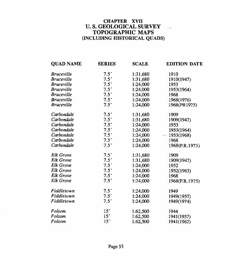
CHAPTER X
SWAMP AND OVERFLOWED
SURVEYS
Several swamp and overflowed land surveys were made in areas along the Cosumnes River. Only one of the surveys (S & 0 609) makes a call along
the river; which indicates that the bed of the river was meandered and segregated as sovereign land from the swamp and overflowed lands. S & 0
609 lies in Sections 19, 20 and 29 of Township 6 North, Range 6 East (Mount Diablo Meridian).
Many of the other swamp and overflowed land surveys make calls to the
Cosumnes River, however they do not meander it; some make no reference at all in the description, but show the river on the sketch. This offers little evidence of navigability.
S & 0 825 (Section 29, Township 6 North, Range 6 East) meanders a stream, however, a note in the patent states that the land to be purchased is
situate in Township 5 North, Range 6 East, being all that part of Section 29 lying north of the south bank of the Cosumnes River. This clearly included
the bed of the river within the swamp and overflowed lands. (Note the discrepancy of the township numbers.)
More specific information regarding swamp and overflowed lands is
included in chapter 7 - Chronological Summary of Events.
Page 30

CHAPTER XI
COUNTY BOUNDARIES
The South Fork of the Cosumnes River forms a portion of the boundary between El Dorado County and Amandor County. Throughout the changes of county boundaries all references to the river or its South Fork were to the "centre", "middle", "up" or "down."
Although it is not a part of the boundary of Sacramento County, a call is made to a point on the Cosumnes River.
The Government Code - sections 23103, 23109 and 23134 describe the present boundaries of Amador, El Dorado and Sacramento Counties respectively.
Page 31

CHAPTER XII
REPORTS OF THE CHIEF OF ENGINEERS
UNITED STATES ARMY (CORPS OF ENGINEERS)
Throughout its history the United States Army, Corps of Engineers has
engaged in numerous military and civil works projects. Although its primary responsibility is to the military, it has also acted as the principle
developer of the country's water resources.
In Calif omia, the Corps of Engineers has played an active role in surveying and monitoring its waterways. With the discovery of gold in the Sierra
streams and later hydraulic mining, they focussed their attention on the Sacramento and San Joaquin Rivers and their tributaries.
Some research was conducted by SLC staff regarding the Executive
Documents (Corps of Engineers Reports) revealing matters related to hydraulic mining. Little information was found regarding the Cosumnes
River specifically. Further research in these records may be warranted.
The Executive Document, 47 Congress, 2d Session, 1882-83 described hydraulic mining on the Cosumnes River as follows:
Hydraulic mining, used large jets of water, taken from the river upstream,
and turned on the auriferous deposits. The material washed from the hillsides consisted mostly of sand and the finer detritus called "slickens" but
included gravel, cobbles and boulders. Three ditches taking water from the river were used. Eagle Ditch from the right bank 6 miles above Michigan
Page 32

Bar, discharged opposite Michigan Bar. Empire ditch taking water form the
South and Middle Forks of the Cosumnes, after being used it drains into Indian Creek. Amador and Sacramento Canal and Mining Company Ditch,
takes water from the left bank 16 miles above Michigan Bar. This water was used at the Hill Top Mine on a ridge between the Cosumnes and Arkansas
Creek just before their junction, all the detritus finally gets into the river. At the discharging point at the Hill Top Mine the river becomes dammed up by
an immense mass of coarse material. Below here the river before had quite high and well-defined banks, now the filling has changed the river into
numerous threads and trickles rather than flows between the bars.
Just prior to this Lt. Payson's report (House Executive Document No. 76, 46th Congress, 3d session) revealed that the Cosumnes River was thought
to be the most damaged of the southern streams from the effects of hydraulic mining.
Page 33

CHAPTER XIII
COSUMNES RIVER FLOW DATA AT MICHIGAN BAR
The United States Geological Survey (USGS) has measured the flows in
cubic feet per second (CFS) of the Cosumnes River since the water year 1907-1908. (A water year begins in October and ends the following September.) This water gage is Station Number 11335000 located on the river at Michigan Bar which is at RM 36. The maximum flows occur between December through June (7 months). The summer months are periods of low flow; the river occasionally drying up altogether south of the Meiss Road Bridge (near Sloughhouse at RM 25.8).
Note: "RM" refers to a specific river mile. See also chapter 14- River
Mile Maps for the location of references indicated with "RM."
The following are the mean monthly flows in CFS for the period 1907 -1990:
January 881 February 1168 March 1167 April 1167 May 681 June 248 July 58 August 20 September 14 October 32 November 149 December 442
Page 34

CHAPTER XIV
RIVER MILE MAPS
The following maps show references to river miles (RM) as discussed throughout this report. These maps are portions of the following United States Geological Survey's topographic maps (quads):
Bruceville: 1968, Photo Revised 1980 Galt: 1968, Photo Revised 1980 Elk Grove: 1968, Photo Revised 1979 Sloughhouse: 1968, Photo Revised 1980
Carbondale: 1968, Photo Revised 1980 Folsom SE: 1954, Photo Revised 1980
Irish Hill: 1962 Latrobe: 1949, Photo Revised 1973
Fiddletown: 1949 Placerville: 1949, Photo Revised 1973 Camino: 1952, Photo Revised 1973 Aukum: 1952, Photo Revised 1973
Note: Scale - 1 inch = 2000 feet.
Page 35

CHAPTER XV
SUMMARY OF MAPS
The following lists of United States Geological Survey (USGS) historical
topographic maps (quads) and miscellaneous maps do not particularly pertain to navigability of the Cosumnes River. They were, however, reviewed for evidence of navigability, and are included in this report for reference purposes for future title and boundary investigations.
The USGS historical quads do not offer any particular evidence of navigability.
The miscellaneous maps reviewed are mainly from the State Lands Commission's collection. Several surveys meander portions of the center of the channel; others meander portions of the bank of the river. Those surveys meandering the center of the channel may indicate private ownership to that
point, however, several of these surveys are within the area of the ranchos which excluded the bed of the river. Further investigation of the deeds and
field notes would be necessary to establish any determinations of ownership.
Many of the maps reviewed do not show sufficient detail of the river .
Page49

SLC INDEX#
CMF294
CXA 1918
CXA 1919
CXB 4123A
CXB 4488
CXB 4527
CXB 4532
CHAPTER XVI
MAPS
TITLE
Map showing portion of central California.
Plat of Tract of Land Owned by the Estate of
William Henry Dixon, J. C. Boyd, C. E., 1908.
Plat of a Tract of Land Owned by Edw. F. Dalton, J.C. Boyd, C. E., June, 1923.
Plat Showing the Subdivision of the Two Bodies
of Land "Notoriusly Swampy and Overflowed", J.
R. Hardenbergh, Surveyor General, February 14, 1872.
Plat of Tract of Land Owned by Kate Wiezel and
Margaret Schroth, J.C. Boyd, C. E., June, 1935.
Plat of Tract of Land Owned by Jacqueline
Parkinson and Daniel E. Gunn, J. C. Boyd, C. E., December, 1936.
Survey made April 12, 1920 for Geo. McConnell,
Sacramento County, J.C. Boyd, April 12, 1920.
Page 50

CXB 4552
CXB 4555
CXB 4559
CXB 4560
CXB 4566
LRB 2003
LRB 543
LRT60
No#
Plan of an Estate the Property J. Sheldon, Esq., W. G. Sherman, F. King, May, 1901.
Plat of Survey of Tract of Land Owned by Lewis
C. Thoreson, J. C. Boyd, C. E., 1910.
Plat of Lower One-Fourth of Lot 13 Sheldon
Grant, J.C. and M. D. Boyd, C. E.'s, May, 1931.
Plat of Upper Three-Fourths of Lot 13 Sheldon
Grant, J.C. Boyd, C. E., September, 1929.
Plat of Survey of Tract of Land Owned by Paula
E. Fatjo, J.C. Boyd, C. E., August, 1909.
Assessor's Map Book 146, Page 13, Sacramento
County.
Swamp Land District No. 2, Sacramento County.
The Valley of Sacramento and San Joaquin Rivers
California from North End of Yolo Basin to
Stockton and Suisun Bay, U. S. Army, Corps of
Engineers, 1908.
Cosumnes River Designated Floodway,
Sacramento County, Hwy 99 to the El Dorado
County Line, State of California, Resources Agency,
Reclamation Board, October 10, 1974.
Page 51

No#
No#
No#(BLM)
No#
No#
Judicial Districts of California and the Counties
Composing the Same.
No label - map showing portion of central California.
Plat of the Claim of Geo. W. Hendy Upon File
Nashville Quartz Mine, Big Canon Situated in
Mining District El Dorado County, California, J. M. Anderson, Deputy Surveyor, August, 1878.
Plat of the Claim of Louis Caffaro known as the
Good Hope, New Virginia and Tiger Gold Quartz
Mines, A. B. Summers, U. S. Deputy Mineral
Surveyor, June, 1901.
The Official Map of the State of California by an --
Act of the Legislature Passed March 25th, 1853,
W. M. Eddy, 1854.
Page 52
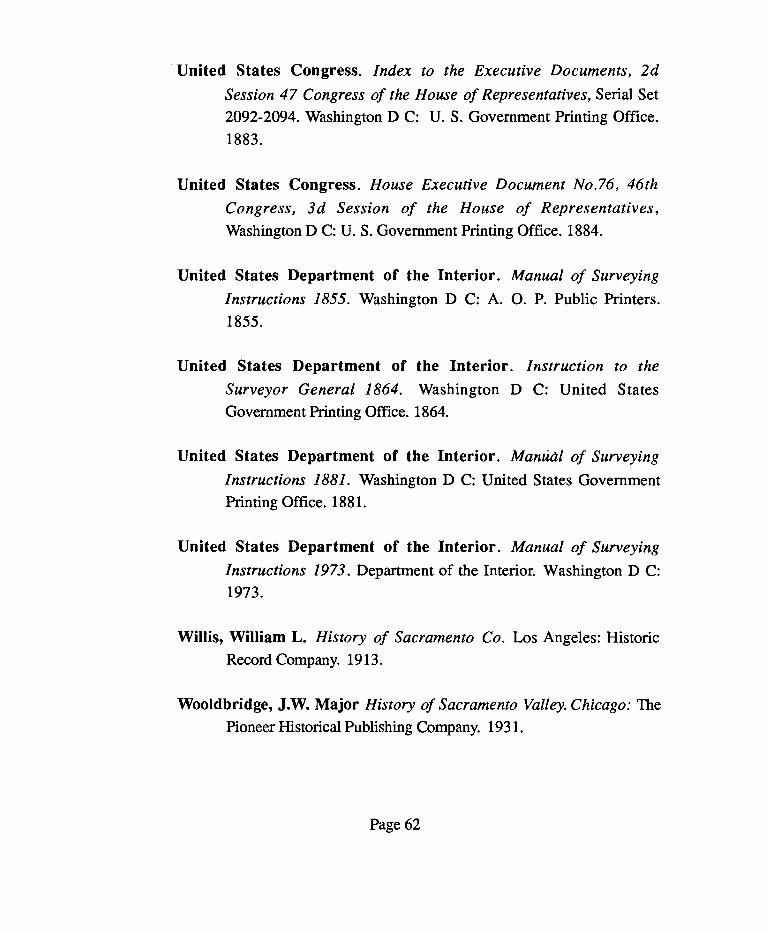
QUAD NAME
Bruceville Bruceville Bruceville Bruceville Bruceville Bruceville Bruceville
Carbondale Carbondale Carbondale Carbondale Carbondale Carbondale Carbondale
Elk Grove Elk Grove Elk Grove Elk Grove Elk Grove Elk Grove
Fiddletown Fiddle town Fiddletown
Folsom Folsom Folsom
CHAPTER XVII U. S. GEOLOGICAL SURVEY
TOPOGRAPHIC MAPS (INCLUDING HISTORICAL QUADS)
SERIES SCALE
7.5' 1:31,680 7.5' 1:31,680 7.5' 1:24,000 7.5' 1:24,000 7.5' 1:24,000 7.5' 1:24,000 7.5' 1:24,000
7.5' 1:31,680 7.5' 1:31,680 7.5' 1:24,000 7.5' 1:24,000 7.5' 1:24,000 7.5' 1:24,000 7.5' 1:24,000
7.5' 1:31,680 7.5' 1:31,680 7.5' 1:24,000 7.5' 1:24,000 7.5' 1:24,000 7.5' 1:24,000
7.5' 1:24,000 7.5' 1:24,000 7.5' 1:24,000
15' 1:62,500 15' 1:62,500 15' 1:62,500
Page 53
EDITION DATE
1910 1910(1947) 1953 1953(1964) 1968 1968(1976) 1968(PR1975)
1909 1909(1947) 1953 1953(1964) 1953(1968) 1968 1968(P.R.1975)
1909 1909(1947) 1952 1952(1963) 1968 1968(P.R.1975)
1949 1949(1957) 1949(1974)
1944 1941(1957) 1941(1962)

QUAD NAME SERIES SCALE EDITION DATE
Folsom S. E. 7.5' 1:24,000 1954 Folsom S. E. 7.5' 1:24,000 1954(1963) Folsom S. E. 7.5' 1:24,000 1954(P.R.197 5)
Franklin 15' 1:62,500 1942
Galt 7.5' 1:31,680 1910 Galt 7.5' 1:31,680 1910(1947) Galt 7.5' 1:24,000 1953 Galt 7.5' 1:24,000 1953(1965) Galt 7.5' 1:24,000 1968
Latrobe 7.5' 1:24,000 1950 Latrobe 7.5' 1:24,000 1949(1956) Latrobe 7.5' 1:24,000 1949(P.R.1973)
Placerville 15' 1:62,500 1949 Placerville 15' 1:62,500 1949(1953) Placerville 15' 1:62,500 1949(1958) Placerville 15' 1:62,500 1949(1966) Placerville 15' 1:62,500 1949(1977)
Sacramento 30' 1:125,000 1891 Sacramento 30' 1:125,000 1892 Sacramento 30' 1:125,000 1892(1896) Sacramento 30' 1:125,000 1892(1900) Sacramento 30' 1:125,000 1892(1906) Sacramento 30' 1:125,000 1892(1908) Sacramento 30' 1:125,000 1892(1916) Sacramento 30' 1:125,000 1892(1929)
Sacramento 2°xl 0 1:250,000 1947 Sacramento 2"xl • 1:250,000 1947(1956) Sacramento 2°xl 0 1:250,000 1947(1961) Sacramento 2°xl 0 1:250,000 1947(1964) Sacramento 2"xl • 1:250,000 1947(1969) Sacramento 2°xl 0 1:250,000 1957(1970)
Page 54

QUAD NAME SERIES SCALE EDITION DATE
Sacramento Valley 2°xl 0 1:250,000 1911
Cosumne* 7.5' 1:31,680 1909 Cosumne* 7.5' 1:31,680 1909(1947) Sloughhouse 7.5' 1:24,000 1953 Sloug hhouse 7.5' 1:24,000 1953(1964) Sloughhouse 7.5' 1:24,000 1968 Sloughhouse 7.5' 1:24,000 1968(P.R.1975)
Note:
Dates shown in parenthesis indicate reprinted editions. Photo revisions are shown as P.R.
*Cosumne quad was renamed Sloughhouse.
Page 55

CHAPTER XVIII
ADDITIONAL RESEARCH SOURCES
The following is a list of sources that should be reviewed if additional
information is needed.
California Department of Water Resources - Library
University of California - Berkeley -The Bancroft Library
U. S. Department of the Interior - Bureau of Reclamation
U. S. Army - Corps of Engineers - Reports and Maps
Sacramento, El Dorado and Amador County Libraries
Individuals with collections or knowledge of the Cosumnes River and adjacent area.
Page 56

SECTION
BIBLIOGRAPHY
Andrus, Susan Elizabeth. The Economic Impacts and Benefits of
Whitewater Recreation in California. Susan Elizabeth Andrus.
1984.
Brodksy, Anne. Understanding the Term, "Navigability", A Report to
the Joint Interim Subcommittee on the Studies of Montana's
Waterways and State Lands. 1984.
California Congress. California Wild and Scenic Rivers Act. Statutes of
1972, Chapter 1259.
California Department of Public Works. Flood Flows and Stages in
Sacramento and Northern San Joaquin Valleys. State Printing Office. 1948.
California Department of Water Resources. Dams within
Jurisdiction of the State of California (Bulletin 17-88). October,
1988.
California State Lands Commission. Colorado River - Davis Lake
Area Project Boundary Study. State Lands Commission. 1976.
Cassady, Jim and Calhoun,.Fryer California Whitewater. Richmond,
CA: Cassady/Calhoun. 1984.
Page 57

Coy, Owen C. Ph.D. California County Boundaries. Berkeley:
Publication of the California Historical Survey Commission. 1973.
Davis, Win. J. An Illustrated History of Sacramento Co. 1851. Chicago:
Lewis Publishing Company, 1890.
Dougherty Jr., Clement J., Deputy County Counsel, Sacramento Co.
Navigability of the Cosumnes River. 1975.
Gudde, Erwin G. California Place Names. Berkeley: University of
California Press. 1969.
Evans, Jay and Anderson, Robert E. Kyaking: The New
Whitewater Sport for Everbody. S. Green Press. 1983.
Gudde, Erwin G. California Gold Camps. University of California Press.
1975.
Guinn, James Miller, Prof. History of the State of California and
Biographical Records of the Sacramento Valley. Chicago:
Chapman Publishing Co. 1906.
Guinn, J. M., Prof. History of the State of California and Biographical
Records of the San Joaquin County. Chicago: Chapman Publishing
Co. 1906.
Guinn, J. M., Prof. History of the State of California and Biographical
Records of the Sierras. Chicago: Chapman Publishing Co. 1906.
Page 58

Hagwood, Joseph J. Jr. Commitment to Excellence - A History of the
Sacramento District, U. S. Army Corps of Engineers 1929 -
1973. Sacramento: U.S. Army Engineer District. 1976.
Harris, Thomas. Down the Wild Rivers - A Guide to the Streams of
California. San Francisco: Chronicle Books. 1972.
Holbek, Lars and Stanley, Chuck. A Guide to the Best Whitewater
in California. Stanford: Friends of the River Books. 1984.
Hoover, Mildred B., Hero Eugene Rensch, Ethel Grace Rensch,
Revised by William N. Abeloe. Historic Spots in California, 3rd Edition. Stanford University Press. 1966, Reprint 1970.
Horgan,Paul, Whitewater. New York: Parras, Straus and Giroux. 1970.
Jones and Stokes Assoc., and VTN Sacramento. Final Report
Cosumnes River Basin Resources Study. San Fransisco: Jones and
Stokes Assoc. and VTN Sacramento. 1974.
Lewis Publishing Company. Illustrated History of San Joaquin County
California. Chicago: The Lewis Publishing Co. 1890.
MacMullen, Jerry. Paddle Wheel Days in Sacramento. Stanford University Press. 1948.
Margulis, Rena K. The Complete Guide to Whitewater Rafting Tours. Palo Alto: Aquatic Adventure Publications. 1986.
Page 59

Martin, Charles. Sierra Whitewater. Sunnyvale, CA: Fiddleneck Press.
1974.
McGowan, Joseph A. Ph. D. History of Sacramento Valley. New York
and W. Palm Beach: Louis Historic Publication. 1961.
Pacific Gas and Electric Company. The Cosumnes River Basin. PG&E Progress, Vol. 38, No. 7 (July, 1961).
Pacific Gas and Electric Company. River of California. PG&E
Progress, ( 1962).
Patterson, A. and Rand Herbert and Stephen Wee. Historical
Evaluation of the Delta Waterways Final Report. State Lands
Commission, 1978.
Patterson, A. and Rand Herbert and Stephen We e. Historical
Evaluation of the Delta Waterways Report #2. State Lands
Commission. 1978.
Patton, Rufford G. and Carroll G. Patton. Patton on Titles. St. Paul:
West Publishing Co. 1957.
Powers, Kenny. "Alaska's Gulkana River Case Sets Federal Navigability
Standard." The WAGLAC Reporter - Newsletter of the Western
Attorney's General Litigation Action Committee. Spring, 1990.
Reed, G. Walter. History of Sacramento Co. Los Angeles: Historic
Record Company. 1923.
Page60

Schneider, J. Public Access Rights To Recreational Waters & Public
Trust Easements Within Rancho Murieta. Jay Schneider. 1987.
Sioli, Paolo History of El Dorado County California. Oakland: Paolo
Sioli. 1883.
South, Arethusa A. Thesis "Inland Navigation." 1935.
Stanley, Owen G. Brief History of Hydraulic Mining, Gold Dredging,
Creation of the California Debris Commission, and Birth of the
Sacramento District of the Corps of Engineers. October, 1865.
Thompson and West. History of Amador County California. Oakland:
Thompson and West. Reprint: 1968.
Thompson and West. History of San Joaquin County California. Oakland: Thompson and West. 1879. Reprint: 1968.
Thompson and West. History of Sacramento County California. Oakland: Thompson and West. 1880.
Tinkham, George H. History of San Joaquin County California. Los
Angeles: Historic Record Co. 1923.
United States Army, Chief of Engineers. Index to the Reports of the
Chief of Engineers, U. S. Army, 1866 - 1900. Washington DC:
U. S. Government Printing Office. 1915.
United States Army, Corps of Engineers. The California Debris Commission, A History. Sacramento: U. S. Army, Corps of Engineers.
Page 61
United States Congress. Index to the Executive Documents, 2d
Session 47 Congress of the House of Representatives, Serial Set
2092-2094. Washington DC: U.S. Government Printing Office.
1883.
United States Congress. House Executive Document No.76, 46th
Congress, 3d Session of the House of Representatives, Washington DC: U.S. Government Printing Office. 1884.
United States Department of the Interior. Manual of Surveying
Instructions 1855. Washington D C: A. 0. P. Public Printers.
1855.
United States Department of the Interior. Instruction to the
Surveyor General 1864. Washington D C: United States
Government Printing Office. 1864.
United States Department of the Interior. Manual of Surveying
Instructions 1881. Washington D C: United States Government
Printing Office. 1881.
United States Department of the Interior. Manual of Surveying
Instructions 1973. Department of the Interior. Washington D C:
1973.
Willis, William L. History of Sacramento Co. Los Angeles: Historic
Record Company. 1913.
Wooldbridge, J.W. Major History of Sacramento Valley. Chicago: The
Pioneer Historical Publishing Company. 1931.
Page 62

CHAPTER XVII
SOURCES
California State Lands Commission
Map and Boundary Book Library
Maps Books
Public Land Surveys Historical Quads
Swamp and Overflowed Land Surveys and Locations
San Joaquin County General File San Joaquin County - Mokelumne River General File
Statutes - Political Codes W 503.813 - River Protection Assoc.
California State Library
California Room
Books Newspapers (for particular dates of reference)
Sacramento Union
Sacramento Bee
Page63

California State Library cont.
Government Publications U. S. Army, Corps of Engineers Reports
U. S. Geological Survey Reports
Law Library
Statutes
Federal Reports
University of California, Berkeley - Bancroft Library Books News papers
Contacts: Elizabeth K. Houser, Sacramento, CA.
Page 64