Embed Size (px)
Citation preview
1
NAVAL RESERVE OFFICERS TRAINING CORPS NAVIGATION I
CNET P1550/3 (Rev. 8-01) CHIEF OF NAVAL EDUCATION AND TRAINING
SF 080103
i
NAVAL RESERVE OFFICERS TRAINING CORPS NAVIGATION I
TABLE OF CONTENTS
Page Table of Contents i Record of Changes ii Letter of Promulgation iii Definition of Measurement Terms iv Professional Competency Objectives v Lesson Topics ix Instructional Aids x Bibliography xiv Lesson Guides 1-98 Suggested Laboratory Topics Appendix A Instructor and Student Reference Articles Appendix B a. The USS Gonzalez (DDG-66) Grounding Case Study (Lesson 22) b. The Bolinao Affair Case Study (Lesson 28)

ii
Navigation I (CNET P1550/3)
RECORD OF CHANGES
CHANGE NO. DATE OF CHANGE DATE ENTERED ENTERED BY
iii
iv
DEFINITION OF MEASUREMENT TERMS
I. Know - Recall facts, bring to mind the appropriate material; recognize knowledge.
Examples: Know the objectives of damage control aboard ship.
Know the safety procedures used to provide
the fullest measure of safe small boat operations.
II. Comprehend - Interpret principles and concepts and relate them to new situations.
Examples: Comprehend the mission of the U.S. Navy and the U.S. Marine Corps.
Comprehend the concepts of internal forces (e.g., stress, strain, shear).
III. Apply - Utilize knowledge and comprehension of specific facts in new relationships with other facts, theories, and principles.
Examples: Apply correct plotting procedures when navigating in piloting waters.
Apply correct procedures to determine times of sunrise and sunset.
IV. Demonstrate - Show evidence of ability in performing a task.
Examples: Demonstrate third-class swimming skills and water survival skills.
Demonstrate the correct procedures used in radio-telephone communications.
v
NAVAL RESERVE OFFICERS TRAINING CORPS NAVIGATION I
PROFESSIONAL COMPETENCY OBJECTIVES
The following professional core competency objective statements for this course are taken from the Professional Core Competency Manual for Officer Accession Programs promulgated in 2001. 1. The student will comprehend the moral and ethical responsibilities of the military leader. a. The student will comprehend the leader's moral and ethical responsibilities to the organization and society. b. The student will comprehend the relationship of integrity, moral courage and ethical behavior to authority, responsibility and accountability. 2. The student will know the fundamentals and limitations of space-based navigation and comprehend the operation of the global positioning system and the uses of precise positioning and time. 3. The student will comprehend the following personal qualities and be able to relate them to a leader's effectiveness: a. Loyalty b. Honor c. Integrity d. Courage (moral) 4. The student will know the theory and information that can be obtained from the practice of celestial navigation at sea. a. The student will know the motions of celestial bodies and relate these motions to coordinate systems. b. The student will comprehend the longitude/time relationship and time conversion, zone time determination and motions of the sun as the basis of time. c. The student will know the correct procedures to determine the times of sunrise and sunset.
vi
d. The student will know the use of computer-based celestial observation sight reduction and computer-based Nautical Almanacs. 5. The student will comprehend the theory and practice of marine navigation by GPS/NAVSSI and other electronic methods. a. The student will know the theory and basic principles of radar navigation. b. The student will know the theory and basic operating principles of GPS/NAVSSI, including the importance of correcting for differences between the GPS/NAVSSI and navigation chart datum. c. The student will know the basic principles of inertial navigation and bottom contour navigation. 6. The student will apply the fundamentals of the practice of marine navigation at sea. a. The student will comprehend the uses of navigational datums and various chart projections. The student will know chart symbology, particularly those symbols pertaining to hazards and dangers. b. The student will know how to select the proper chart (both paper and electronic) and how to determine chart accuracy and reliability. c. The student will apply correct plotting procedures when navigating in pilot waters. (1) The student will apply the six rules of dead reckoning in keeping a plot of ship's movements. (2) The student will comprehend the definitions of the terms: track, speed of advance, speed over ground, PIM, EP, LOP, relative bearing and course made good. (3) The student will plot and interpret danger and turn bearings. (4) The student will plot and interpret simultaneous and running fixes.
vii
(5) The student will know the variables to compute the visibility of lights. d. The student will know the advantages, disadvantages, and applications of gyro and magnetic compasses. (1) The student will apply terrestrial navigation methods to determine compass error. (2) The student will apply magnetic variation and deviation or gyro error to convert from compass to true course or bearing and vice versa. e. The student will know the capabilities and limitations of various instruments used in piloting to determine direction, speed, distance, and depth of water. f. The student will know the essential publications and records used in navigation and comprehend their value in all applications. g. The student will know the characteristics and application of various aids to navigation in piloting and comprehend their importance in safe navigation, including: (1) buoyage systems - IALA (2) lights/daymarkers (3) sound signals (4) radar beacons/markers h. The student will apply correct procedures in planning and plotting approaches to harbors and anchorages. i. The student will comprehend tidal action and know tide classifications and reference planes. 7. The student will know the environmental weather factors affecting naval operations. a. The student will know the basic principles of basic weather phenomenon, including fronts, subtropical and tropical storms. b. The student will know the relationship between wind and current in wind-driven current systems.
viii
c. The student will know the sources of environmental predictions, including pilot charts and weather broadcasts. d. The student will know the earth’s major wind and current systems. e. The student will know how wind velocity relates to storm warnings and comprehend the effect of wind velocity on sea state. f. The student will know the characteristics of the approach of tropical storms and hurricane/typhoon evasion techniques. 8. The student will know inland and international laws and systems of regulations which govern conduct of vessels in national waters and on the high seas. a. The student will know the major aspects of the United States' position on International Law of the Sea regarding territorial seas, contiguous zones, high seas, and rights of innocent passage. b. The student will know the U.S. Inland Rules of the Road and the international regulations for preventing collisions at sea to include: (1) The purpose and scope of the rules, including application. (2) Terms and definitions used in the rules. (3) Steering rules for vessels in sight of each other, including sound signals. (4) Lights and day shapes for frequently encountered vessel classes. (5) Use of radar and conduct of vessels in reduced visibility, including sound signals. (6) Definition of situations falling under "special circumstances." c. The student will know the purpose and maneuvering rules associated with Traffic Separation schemes established by the International Maritime Consultive Organization (IMCO) agreement.
ix
NAVAL RESERVE OFFICERS TRAINING CORPS NAVIGATION I
LESSON TOPICS
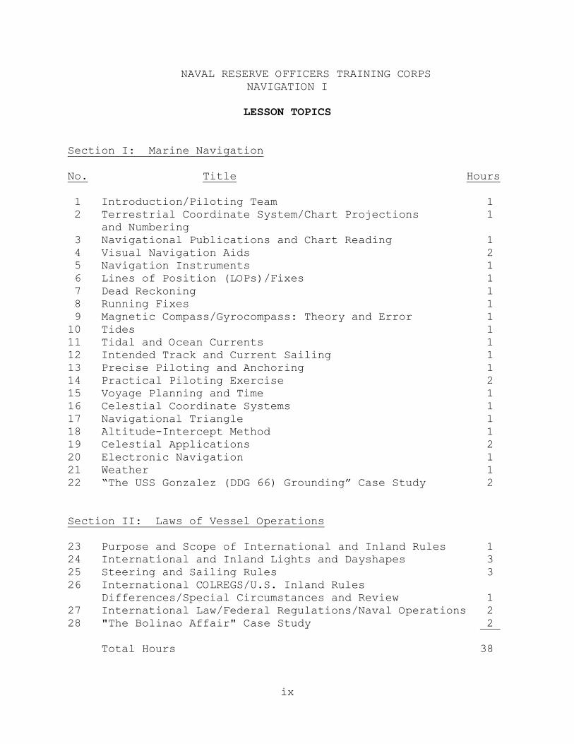
Section I: Marine Navigation No. Title Hours 1 Introduction/Piloting Team 1 2 Terrestrial Coordinate System/Chart Projections 1 and Numbering 3 Navigational Publications and Chart Reading 1 4 Visual Navigation Aids 2 5 Navigation Instruments 1 6 Lines of Position (LOPs)/Fixes 1 7 Dead Reckoning 1 8 Running Fixes 1 9 Magnetic Compass/Gyrocompass: Theory and Error 1 10 Tides 1 11 Tidal and Ocean Currents 1 12 Intended Track and Current Sailing 1 13 Precise Piloting and Anchoring 1 14 Practical Piloting Exercise 2 15 Voyage Planning and Time 1 16 Celestial Coordinate Systems 1 17 Navigational Triangle 1 18 Altitude-Intercept Method 1 19 Celestial Applications 2 20 Electronic Navigation 1 21 Weather 1 22 “The USS Gonzalez (DDG 66) Grounding” Case Study 2 Section II: Laws of Vessel Operations 23 Purpose and Scope of International and Inland Rules 1 24 International and Inland Lights and Dayshapes 3 25 Steering and Sailing Rules 3 26 International COLREGS/U.S. Inland Rules Differences/Special Circumstances and Review 1 27 International Law/Federal Regulations/Naval Operations 2 28 "The Bolinao Affair" Case Study 2 Total Hours 38
x
NAVAL RESERVE OFFICERS TRAINING CORPS NAVIGATION I
INSTRUCTIONAL AIDS
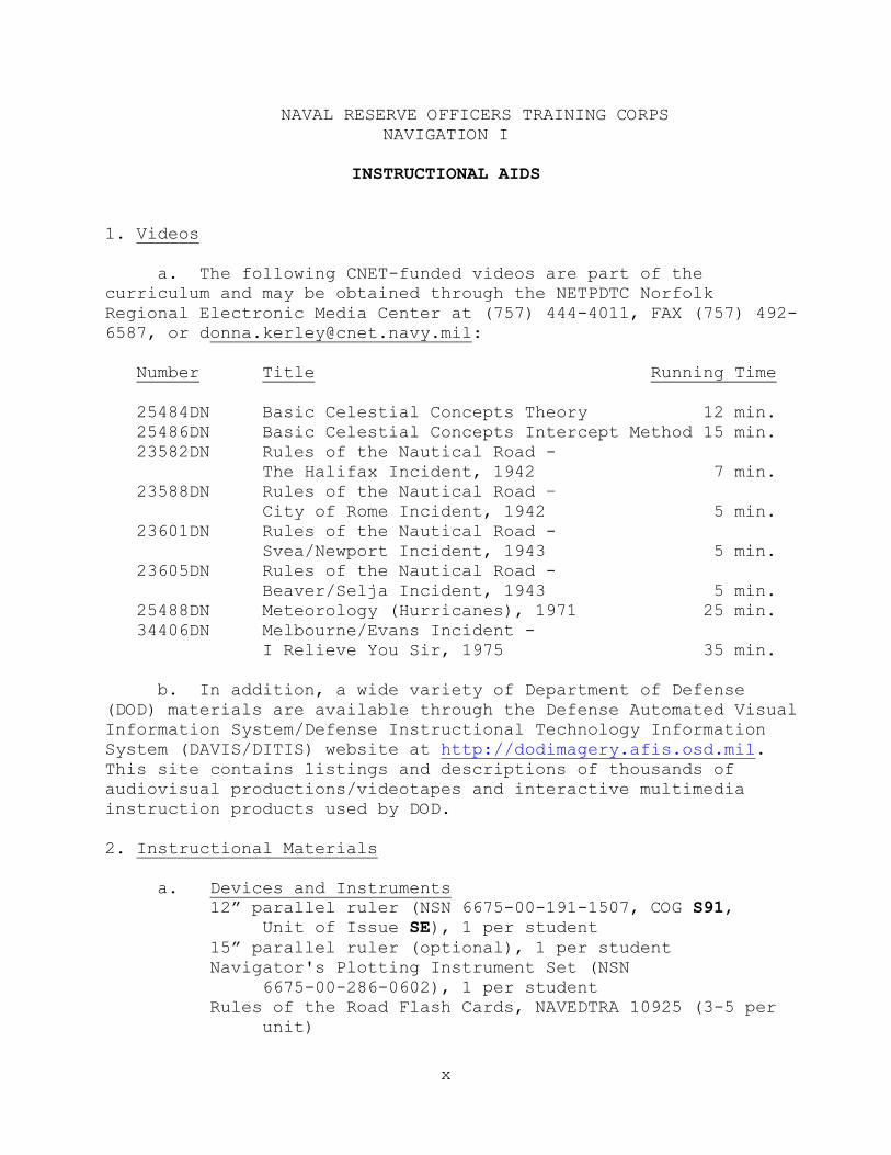
1. Videos a. The following CNET-funded videos are part of the curriculum and may be obtained through the NETPDTC Norfolk Regional Electronic Media Center at (757) 444-4011, FAX (757) 492-6587, or [email protected]: Number Title Running Time 25484DN Basic Celestial Concepts Theory 12 min. 25486DN Basic Celestial Concepts Intercept Method 15 min. 23582DN Rules of the Nautical Road - The Halifax Incident, 1942 7 min. 23588DN Rules of the Nautical Road – City of Rome Incident, 1942 5 min. 23601DN Rules of the Nautical Road - Svea/Newport Incident, 1943 5 min. 23605DN Rules of the Nautical Road - Beaver/Selja Incident, 1943 5 min. 25488DN Meteorology (Hurricanes), 1971 25 min. 34406DN Melbourne/Evans Incident - I Relieve You Sir, 1975 35 min. b. In addition, a wide variety of Department of Defense (DOD) materials are available through the Defense Automated Visual Information System/Defense Instructional Technology Information System (DAVIS/DITIS) website at http://dodimagery.afis.osd.mil. This site contains listings and descriptions of thousands of audiovisual productions/videotapes and interactive multimedia instruction products used by DOD. 2. Instructional Materials a. Devices and Instruments
12” parallel ruler (NSN 6675-00-191-1507, COG S91, Unit of Issue SE), 1 per student
15” parallel ruler (optional), 1 per student Navigator's Plotting Instrument Set (NSN 6675-00-286-0602), 1 per student Rules of the Road Flash Cards, NAVEDTRA 10925 (3-5 per unit)
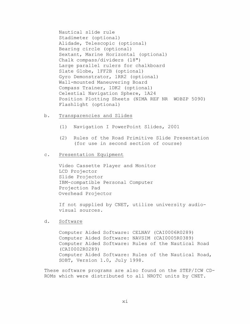
xi
Nautical slide rule Stadimeter (optional) Alidade, Telescopic (optional) Bearing circle (optional) Sextant, Marine Horizontal (optional) Chalk compass/dividers (l8") Large parallel rulers for chalkboard Slate Globe, 1FF2B (optional) Gyro Demonstrator, 1RR2 (optional) Wall-mounted Maneuvering Board Compass Trainer, 1DK2 (optional) Celestial Navigation Sphere, 1A24 Position Plotting Sheets (NIMA REF NR WOBZP 5090) Flashlight (optional) b. Transparencies and Slides
(1) Navigation I PowerPoint Slides, 2001 (2) Rules of the Road Primitive Slide Presentation
(for use in second section of course) c. Presentation Equipment Video Cassette Player and Monitor LCD Projector Slide Projector IBM-compatible Personal Computer Projection Pad Overhead Projector If not supplied by CNET, utilize university audio- visual sources. d. Software Computer Aided Software: CELNAV (CAI0006R0289) Computer Aided Software: NAVSIM (CAI0005R0389) Computer Aided Software: Rules of the Nautical Road (CAI0002R0289) Computer Aided Software: Rules of the Nautical Road,
SOBT, Version 1.0, July 1998.
These software programs are also found on the STEP/ICW CD-ROMs which were distributed to all NROTC units by CNET.
xii
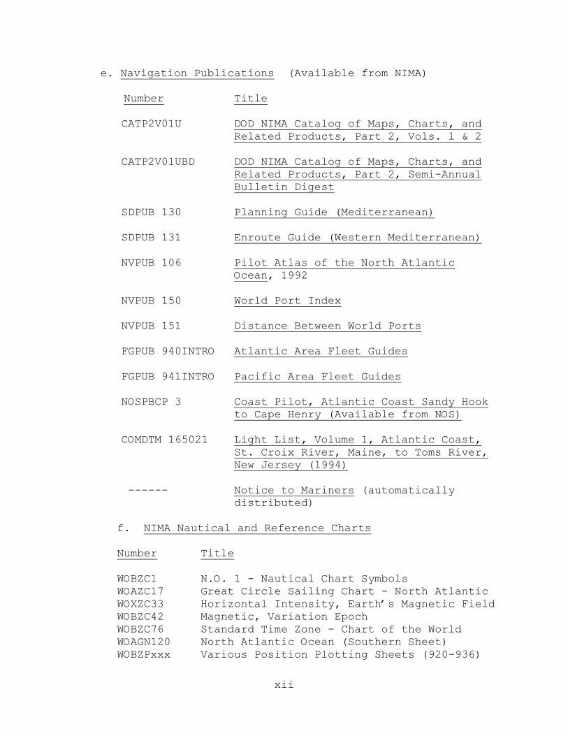
e. Navigation Publications (Available from NIMA) Number Title CATP2V01U DOD NIMA Catalog of Maps, Charts, and Related Products, Part 2, Vols. l & 2 CATP2V01UBD DOD NIMA Catalog of Maps, Charts, and Related Products, Part 2, Semi-Annual Bulletin Digest SDPUB 130 Planning Guide (Mediterranean) SDPUB 131 Enroute Guide (Western Mediterranean)
NVPUB 106 Pilot Atlas of the North Atlantic Ocean, 1992
NVPUB 150 World Port Index NVPUB 151 Distance Between World Ports FGPUB 940INTRO Atlantic Area Fleet Guides FGPUB 941INTRO Pacific Area Fleet Guides NOSPBCP 3 Coast Pilot, Atlantic Coast Sandy Hook to Cape Henry (Available from NOS) COMDTM 165021 Light List, Volume 1, Atlantic Coast, St. Croix River, Maine, to Toms River, New Jersey (1994) ------ Notice to Mariners (automatically distributed) f. NIMA Nautical and Reference Charts Number Title WOBZC1 N.O. 1 - Nautical Chart Symbols WOAZC17 Great Circle Sailing Chart - North Atlantic WOXZC33 Horizontal Intensity, Earth’s Magnetic Field WOBZC42 Magnetic, Variation Epoch WOBZC76 Standard Time Zone - Chart of the World WOAGN120 North Atlantic Ocean (Southern Sheet) WOBZPxxx Various Position Plotting Sheets (920-936)

xiii
12AHA 12221 Chesapeake Bay Entrance 12AHA 12254 Cape Henry to Thimble Shoals Light 12AHA 12270 Eastern Bay & South River - Chesapeake Bay Entrance BCXBC E0803 Bottom Contour Chart (N. coast of Colombia)
xiv
NAVAL RESERVE OFFICERS TRAINING CORPS NAVIGATION I
BIBLIOGRAPHY
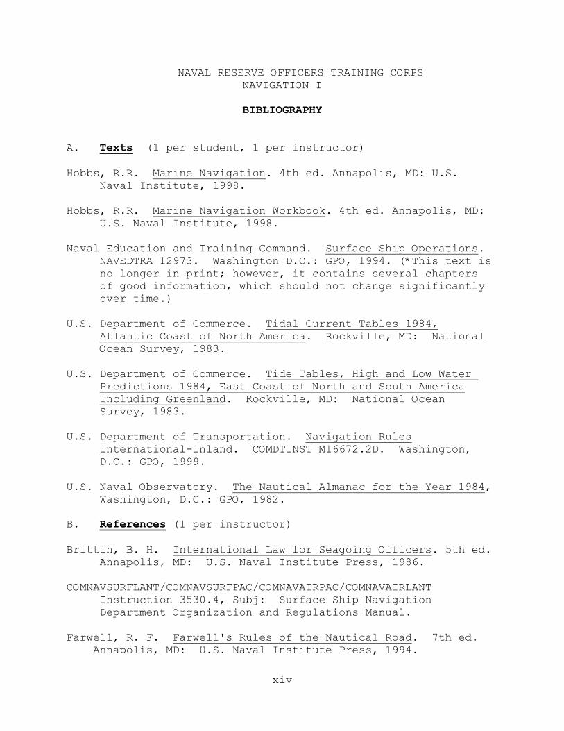
A. Texts (1 per student, 1 per instructor) Hobbs, R.R. Marine Navigation. 4th ed. Annapolis, MD: U.S.
Naval Institute, l998.
Hobbs, R.R. Marine Navigation Workbook. 4th ed. Annapolis, MD: U.S. Naval Institute, 1998.
Naval Education and Training Command. Surface Ship Operations.
NAVEDTRA 12973. Washington D.C.: GPO, 1994. (*This text is no longer in print; however, it contains several chapters of good information, which should not change significantly over time.)
U.S. Department of Commerce. Tidal Current Tables 1984,
Atlantic Coast of North America. Rockville, MD: National Ocean Survey, 1983.
U.S. Department of Commerce. Tide Tables, High and Low Water Predictions 1984, East Coast of North and South America Including Greenland. Rockville, MD: National Ocean Survey, 1983. U.S. Department of Transportation. Navigation Rules International-Inland. COMDTINST M16672.2D. Washington, D.C.: GPO, 1999. U.S. Naval Observatory. The Nautical Almanac for the Year 1984, Washington, D.C.: GPO, 1982. B. References (1 per instructor) Brittin, B. H. International Law for Seagoing Officers. 5th ed. Annapolis, MD: U.S. Naval Institute Press, 1986. COMNAVSURFLANT/COMNAVSURFPAC/COMNAVAIRPAC/COMNAVAIRLANT Instruction 3530.4, Subj: Surface Ship Navigation Department Organization and Regulations Manual. Farwell, R. F. Farwell's Rules of the Nautical Road. 7th ed. Annapolis, MD: U.S. Naval Institute Press, 1994.
xv
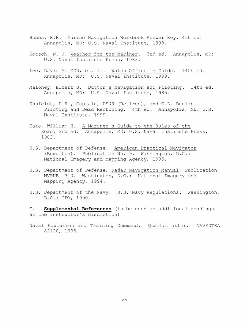
Hobbs, R.R. Marine Navigation Workbook Answer Key. 4th ed.
Annapolis, MD: U.S. Naval Institute, 1998. Kotsch, W. J. Weather for the Mariner. 3rd ed. Annapolis, MD: U.S. Naval Institute Press, 1983. Lee, David M. CDR, et. al. Watch Officer's Guide. 14th ed. Annapolis, MD: U.S. Naval Institute, 1999. Maloney, Elbert S. Dutton's Navigation and Piloting. 14th ed. Annapolis, MD: U.S. Naval Institute, 1985. Shufeldt, H.H., Captain, USNR (Retired), and G.D. Dunlap. Piloting and Dead Reckoning. 4th ed. Annapolis, MD: U.S. Naval Institute, 1999. Tate, William H. A Mariner's Guide to the Rules of the Road. 2nd ed. Annapolis, MD: U.S. Naval Institute Press, 1982. U.S. Department of Defense. American Practical Navigator (Bowditch). Publication No. 9. Washington, D.C.: National Imagery and Mapping Agency, 1995. U.S. Department of Defense, Radar Navigation Manual, Publication
NVPUB l3l0. Washington, D.C.: National Imagery and Mapping Agency, 1994.
U.S. Department of the Navy. U.S. Navy Regulations. Washington, D.C.: GPO, 1990. C. Supplemental References (to be used as additional readings at the instructor's discretion) Naval Education and Training Command. Quartermaster. NAVEDTRA 82120, 1995.
1
NAVAL RESERVE OFFICERS TRAINING CORPS NAVIGATION I
LESSON GUIDE: 1 HOURS: 1 TITLE: Introduction/Piloting Team I. Learning Objectives A. The student will know the professional core competency
objectives for the Navigation I curriculum. B. The student will know the duties of the piloting team
members. C. The student will know the navigation department’s
operational and administrative structures. II. References and Texts A. Instructor references 1. Marine Navigation, Hobbs, Chapters 1, 2, 3 2. Marine Navigation Workbook B. Student texts 1. Marine Navigation, Hobbs, Chapters 1, 2, 3 2. Marine Navigation Workbook III. Instructional Aids A. Course syllabus (prepared by instructor) B. Chalkboard C. PowerPoint Slides IV. Suggested Methods and Procedures A. Method options 1. Informal introduction by instructor
2
2. Review of course syllabus (course content, grading, etc.)
3. Lecture B. Procedural and student activity options:
Distribute required course materials and publications. V. Presentation A. Introduction of instructor B. Review the course syllabus and outline broad objectives of this curriculum as delineated on pages v-viii. C. Discuss the members of the piloting team. D. Discuss the Navigation Department’s organization. 1. Administrative 2. Operational
3
NAVAL RESERVE OFFICERS TRAINING CORPS NAVIGATION I
LESSON GUIDE: 2 HOURS: 1 TITLE: Terrestrial Coordinate System/Chart Projections and Numbering I. Learning Objectives A. The student will comprehend the terrestrial coordinate system. B. The student will comprehend the location of positions on earth using latitude and longitude. C. The student will comprehend the basic properties of the most commonly used chart projections. D. The student will know the chart numbering system. E. The student will comprehend the chart/publication
correction system. II. References and Texts A. Instructor references
1. Marine Navigation, Hobbs, Chapter 4 2. American Practical Navigator, Bowditch, Chapters
2, 3, 5
3. Dutton's Navigation and Piloting, Maloney, Chapters 2, 5
4. Marine Navigation Workbook B. Student texts 1. Marine Navigation, Hobbs, Chapter 4 2. Marine Navigation Workbook III. Instructional Aids
4
A. Slate globe (recommended) B. PowerPoint Slides C. Chart numbers 17 and 76 or substitutes D. Notice to Mariners E. Overhead projector IV. Suggested Methods and Procedures A. Method options: Lecture/Demonstration B. Procedural and student activity options 1. Complete assigned reading 2. Complete assigned workbook exercises V. Presentation A. Using the slate globe and/or transparencies, develop the terrestrial coordinate system by explaining: 1. Spheroid versus sphere shape 2. Axis and poles 3. Great circles versus small circles 4. The equator and the angular measures of latitude small circles 5. Greenwich meridian and the angular measurement of longitude great circles 6. Measurement of latitude along meridians; the
contraction of the longitude scale 7. Labeling of longitude and latitude B. Discuss the desirable properties for any projection. Differentiate between a chart and a map.
5
C. Using the map projection demonstrator, slate globe, and/or transparencies, illustrate plane, conic, and cylindrical projections; define and differentiate the various terms. 1. Points of tangency 2. Reference points of projection D. Using the world chart, discuss the characteristics of
each projection, the inherent distortions, and the desirable properties.
1. Conformal 2. True shape 3. Distortion of true size 4. Rhumb lines versus great circles 5. Measurement of distance and direction E. Discuss the characteristics of a gnomonic projection and contrast its appearance, use, and characteristics to a mercator projection. F. Discuss chart scale. G. Discuss chart numbering. H. Describe the chart correction system. 1. Notice to Mariners, Local Notice to Mariners, and HYDROLANTS/HYDROPACS 2. Use of chart correction card 3. Use of NIMA’s NAVINFONET I. Discuss the indicators of chart accuracy. 1. Date of survey 2. Completeness of soundings 3. Chart scale
6
NAVAL RESERVE OFFICERS TRAINING CORPS NAVIGATION I
LESSON GUIDE: 3 HOURS: 1 TITLE: Navigational Publications and Chart Reading I. Learning Objectives A. The student will know how charts are catalogued in the National Imagery and Mapping Agency’s (DMA) Catalog of
Maps, Charts, and Related Products and the National Ocean Service (NOS) Nautical Chart Catalogs.
B. The student will know the contents of the reference publications Coast Pilots, Sailing Directions, Fleet Guides, Light List, List of Lights, Tide and Tidal Current Tables, and the other important texts and manuals used in navigation. C. The student will comprehend how publications are kept up-to-date. D. The student will know hazard and depth symbology used on charts. E. The student will apply basic plotting techniques using nautical charts. F. The student will comprehend the procedures for selecting the proper charts and how to determine chart accuracy and reliability. II. References and Texts A. Instructor references
1. Marine Navigation, Hobbs, Chapter 5 2. American Practical Navigator, Bowditch, Chapters
5, l3
3. Dutton's Navigation and Piloting, Maloney, Chapters 5-6
4. Marine Navigation Workbook

7
B. Student texts 1. Marine Navigation, Hobbs, Chapter 5, Appendix G
2. Marine Navigation Workbook III. Instructional Aids A. Selected publications (Coast Pilot, Fleet Guides, Sailing Directions, Light List, etc.) B. Plotting instruments C. NIMA charts 120 and 12221 or substitutes D. Overhead projector E. Pilot chart F. Laboratory 1 (Appendix A)
G. Laboratory 2 (Appendix A) H. PowerPoint Slides
IV. Suggested Methods and Procedures A. Method options 1. Lecture 2. Student inspection of navigation publications B. Procedural and student activity options 1. Complete assigned reading 2. Complete assigned workbook exercises V. Presentation A. Using the NIMA Catalog and/or transparencies, demonstrate the means by which NIMA charts are catalogued and how charts would be selected for entering a given harbor.
8
B. Identify the various reference publications available to the navigator. 1. Light List, List of Lights 2. Coast Pilot, Sailing Directions, Fleet Guides 3. Tide and Tidal Current Tables 4. Pilot Chart 5. Dutton, Bowditch, etc. C. Using chart number 12221 (or substitute) and Chart Number 1, Appendix G in Hobbs, have students identify various chart symbology -- stress hazards/dangers to navigation and depth/contour markings. D. Using chart 12221, have students plot lat/long positions, determine the lat/long coordinates of various navigational points of reference, and determine distance between two points. E. Have the student complete a practical exercise in
identifying chart symbology. Labs 1 and 2 in Appendix A are provided as an aid to the instructor in fulfilling the requirement of this practical exercise.
9
NAVAL RESERVE OFFICERS TRAINING CORPS NAVIGATION I
LESSON GUIDE: 4 HOURS: 2 TITLE: Visual Navigation Aids I. Learning Objectives A. The student will comprehend the identifying characteristics and significance of lighted aids to navigation. B. The student will apply correct procedures to identify and determine the computed visibility of a navigational light. C. The student will be familiar with the shapes and lights of the International Association of Lighthouse Authorities (IALA) Combined Cardinal and Lateral System of buoyage. D. The student will comprehend the use of buoys and beacons during piloting. II. References and Texts A. Instructor references 1. Marine Navigation, Hobbs, Chapter 6 2. American Practical Navigator, Bowditch, Chapter 4 3. Dutton's Navigation and Piloting, Maloney, Chapter 5 4. Light List, Atlantic Coast 5. Marine Navigation Workbook B. Student texts 1. Marine Navigation, Hobbs, Chapter 6 and applicable sections of Appendix G (Chart No. l) 2. Marine Navigation Workbook
10
III. Instructional Aids A. Light List Atlantic Coast, Vol. I, 1994 B. Chart 12221 (or substitute) C. Chalkboard D. PowerPoint Slides E. Flashlight (optional) F. Laboratory 3 (Appendix A) IV. Suggested Methods and Procedures A. Method options 1. Lecture 2. Practical exercise in computed visibility B. Procedural and student activity options 1. Complete assigned reading 2. Complete assigned workbook exercises V. Presentation A. Discuss the physical and visual attributes of lighted aids to navigation and how these attributes are used to identify the purpose and location of each aid in a marine environment; particularly stress the characteristics commonly used to indicate proximate hazards to navigation or important navigation points. B. Define and delineate each distinguishing light phase characteristic using a flashlight and transparencies. C. Demonstrate the use of the Light List in identifying the characteristics of lighted aids to navigation. 1. Phase 2. Period
11
3. Sectors 4. Alternating 5. Lighted range 6. Nominal range 7. Physical characteristics D. Demonstrate the diagramming of the period of a lighted aid to navigation. E. Illustrate the determination of computed visibility and luminous range. l. Geographic range = horizon distance of light + horizon distance of observer 2. Luminous range = (enter luminous range diagram on p. 92 with nominal range and existing meteorological visibility) 3. Computed visibility F. Demonstrate the plotting of computed visibility. G. Discuss the purpose and general distinguishing features of the IALA Combined Cardinal and Lateral System of buoyage. l. Distinguishing colors, shapes, sound signals, and light characteristics 2. Relationship of shape and distinguishing characteristics with buoy placement and purpose 3. Responsibility for buoyage system maintenance 4. Use of buoys as objects for bearings in piloting
H. Have the students utilize Chart Number 1, Appendix G in Hobbs, to relate the symbology on Chart 12221 to the U.S. Lateral System.
I. Have the students complete a practical exercise in computing the visibility of a navigational light.
12
NAVAL RESERVE OFFICERS TRAINING CORPS NAVIGATION I
LESSON GUIDE: 5 HOURS: 1 TITLE: Navigation Instruments I. Learning Objectives A. The student will comprehend the use of the azimuth circle, the bearing circle, and the alidade in the measurement of direction. B. The student will comprehend the use of the stadimeter in the measurement of distance. C. The student will comprehend the methods by which speed through the water is determined on a ship or boat. D. The student will comprehend the use of hand lead lines and echo sounders to determine depth. E. The student will know basic plotting instruments and apply correct procedures in their use. F. The student will apply correct procedures in the use of log scales and the nautical slide rule to determine speed, time, and distance given any two of the quantities. II. References and Texts A. Instructor references 1. Marine Navigation, Hobbs, Chapter 7 2. American Practical Navigator, Bowditch, Chapter 6 3. Dutton's Navigation and Piloting, Maloney, Chapter 7 4. Marine Navigation Workbook B. Student texts 1. Marine Navigation, Hobbs, Chapter 7 2. Marine Navigation Workbook
13
III. Instructional Aids A. Optional navigation instruments (alidade, bearing circle, stadimeter, sextant) B. Nautical slide rule
C. Position plotting sheet (PPS) and dividers for each student
D. PowerPoint Slides
IV. Suggested Methods and Procedures A. Method options 1. Lecture/Demonstration 2. Student inspection of navigation instruments 3. Practical exercise using PPS B. Procedural and student activity options 1. Complete assigned reading 2. Complete assigned workbook exercises V. Presentation A. Identify the principal components and explain the use of the following: 1. Azimuth circle 2. Telescopic alidade 3. Stadimeter 4. Sextant B. Discuss the general operating characteristics of the
following: 1. Pitometer log
14
2. Doppler speed log 3. Fathometer 4. DRT, its speed and direction input sources and its output of geographic motion 5. Sextant C. Discuss alternative types of plotting instruments available to the navigator. 1. Parallel rulers 2. Parallel motion protractor (PMP) 3. Weems and Parallel plotter 4. Three-arm protractor D. Discuss the means of determining time aboard ship, including the accuracy of each timepiece. 1. Stop watches 2. Wall clocks 3. Chronometers 4. Comparing watches E. Using the time-speed-distance logarithmic scale on the PPS, have the students complete several practical exercises determining speed or distance or time given the two remaining values. F. Demonstrate the use of the nautical slide rule to solve the distance = rate x time problem. G. Discuss the application of the 3-minute and 6-minute rules. H. Discuss weather measurement instruments used by the navigator's personnel on most ships. l. Anemometer -- wind

15
2. Barometer -- barometric air pressure 3. Thermometer -- air temperature 4. Psychrometer -- determination of dew point
16
NAVAL RESERVE OFFICERS TRAINING CORPS NAVIGATION I
LESSON GUIDE: 6 HOURS: 1 TITLE: Lines of Position (LOPs)/Fixes I. Learning Objectives A. The student will comprehend how sources of visual ranges, visual bearings, and distance LOPs are selected, acquired and plotted. B. The student will comprehend which combinations of LOPs used in determining a fix are most reliable and desirable. C. The student will apply correct procedures to become proficient in plotting and labeling fixes. D. The student will comprehend the use of radar in piloting. E. The student will comprehend the use of danger bearings and apply correct procedures to plot and label such bearings. F. The student will comprehend the difference between a fix and an estimated position (EP) and know the proper labeling procedure for EPs. II. References and Texts A. Instructor references 1. Marine Navigation, Hobbs, Chapters 8, l0
2. Dutton's Navigation and Piloting, Maloney, Chapters 1l, 16
3. American Practical Navigator, Bowditch, Chapters 10, 42
4. Piloting and Dead Reckoning, Dunlap, Chapter 11 5. Radar Navigation Manual, Publication 1310
17
6. Marine Navigation Workbook B. Student texts 1. Marine Navigation, Hobbs, pp. 129-134, 142-143,
144-147, 174-176 2. Marine Navigation Workbook III. Instructional Aids A. Chalkboard B. Position plotting sheets (PPS) C. Plotting instruments D. Large compass and parallel rules for chalkboard
E. Overhead projector
F. Laboratory 4 (Appendix A)
G. PowerPoint Slides IV. Suggested Methods and Procedures A. Method options 1. Lecture 2. Demonstration of plotting procedures B. Procedural and student activity options 1. Complete assigned reading 2. Complete assigned workbook exercises V. Presentation A. Define LOP, fix, visual range, and visual bearing. B. Utilizing the chalkboard and transparencies, explain how each is obtained and labeled.

18
C. Discuss which combinations of LOPs are most reliable and desirable. D. Briefly discuss the use of radar as a source of LOPs/fixes, specifically noting that radar is more accurate in range than in bearing. E. Discuss selection of the position of the fix when a triangle is obtained when LOPs intersect. F. Discuss and demonstrate the use, plotting, and labeling of danger bearings in piloting. G. Explain the differences and labeling between an estimated position (EP) and a fix. H. Assign a practical plotting exercise.
19
NAVAL RESERVE OFFICERS TRAINING CORPS NAVIGATION I
LESSON GUIDE: 7 HOURS: 1 TITLE: Dead Reckoning I. Learning Objectives A. The student will know the six rules of dead reckoning (DR). B. The student will apply proper procedures to become proficient in the techniques of maintaining the DR plot. C. The student will apply the three- and six-minute rules
in DR plotting. II. References and Texts A. Instructor references 1. Marine Navigation, Hobbs, Chapter 8 2. Dutton's Navigation and Piloting, Maloney, Chapter 8 3. American Practical Navigator, Bowditch, Chapter 8 4. Piloting and Dead Reckoning, Dunlap, Chapter 10 5. Marine Navigation Workbook B. Student texts 1. Marine Navigation, Hobbs, pp. 134-138, 143-144 2. Marine Navigation Workbook III. Instructional Aids A. Chalkboard B. Position plotting sheets (PPS) C. Plotting instruments
20
D. PowerPoint Slides E. Large chalk compass and parallel rules
F. Laboratory 4 (Appendix A)
IV. Suggested Methods and Procedures A. Method options 1. Lecture 2. Demonstration of plotting that incorporates DR rules B. Procedural and student activity options 1. Complete assigned reading. 2. Complete assigned workbook exercises. V. Presentation A. Discuss the principles of DR and the reasons for plotting a DR. B. Discuss the six rules for keeping a DR plot. C. Using the chalkboard and/or transparencies, demonstrate how to plot a DR of a ship's course and speed vector. D. Explain the application of the three- and six-minute
rules in DR. E. Demonstrate the proper plotting procedures for laying out an intended track. F. Assign a practical exercise in DR plotting (Laboratory
#4 in Appendix A).
21
NAVAL RESERVE OFFICERS TRAINING CORPS NAVIGATION I
LESSON GUIDE: 8 HOURS: 1 TITLE: Running Fixes I. Learning Objectives A. The student will apply correct procedures for advancing two or more non-simultaneous, nonparallel lines of position to establish a running fix. B. The student will apply correct procedures to plot and label a running fix with bearings on different objects, a running fix with bearings on the same object, and a running fix advancing a distance circle of position. C. The student will comprehend the reliability of running fixes compared to simultaneous fixes. II. References and Texts A. Instructor references 1. Marine Navigation, Hobbs, Chapter 8 2. Dutton's Navigation and Piloting, Maloney, Chapter 11 3. American Practical Navigator, Bowditch, Chapter 10 4. Piloting and Dead Reckoning, Dunlap, Chapter 12 5. Marine Navigation Workbook B. Student texts 1. Marine Navigation, Hobbs, pp. 138-142 2. Marine Navigation Workbook III. Instructional Aids A. Chalkboard B. PowerPoint Slides
22
C. Position plotting sheets (PPS)
D. Plotting instruments E. Large chalk compass and parallel rulers F. Laboratory 4 (Appendix A)
IV. Suggested Methods and Procedures A. Method options 1. Lecture 2. Demonstration of plotting procedures B. Procedural and student activity options 1. Complete assigned reading 2. Complete assigned workbook exercises V. Presentation A. Define a running fix and explain when it is needed. l. Explain inherent inaccuracies that multiply over time. 2. Discuss the maximum length of time an LOP may be advanced in piloting. B. Using the chalkboard and transparencies, show how a running fix is constructed. 1. Demonstrate procedures for advancing both bearing
and range LOPs with the ship on constant course and speed.
2. Demonstrate the same procedures for a running fix with the ship changing course and/or speed. C. Explain the rules for obtaining a running fix. 1. Explain the need for an accurate DR. 2. Do not advance LOPs more than 30 minutes.

23
D. Assign a practical plotting exercise. E. Go slowly and use very clear plotting techniques. Students have trouble with this entire concept!
24
NAVAL RESERVE OFFICERS TRAINING CORPS NAVIGATION I
LESSON GUIDE: 9 HOURS: 1 TITLE: Magnetic Compass/Gyrocompass: Theory and Error I. Learning Objectives A. The student will comprehend the basic principles of the operation of the gyrocompass and its advantages and disadvantages. B. The student will apply correct procedures in determining and correcting for gyrocompass and magnetic error. C. The student will comprehend the differences between true, magnetic, gyrocompass, and relative direction reference systems, and apply proper procedures to make direction conversions from any one system to any other. D. The student will comprehend the basic principles of operation of the magnetic compass and its advantages and disadvantages. E. The student will comprehend the reasons for variation and deviation and how these affect the magnetic compass. F. The student will apply proper procedures in converting from true direction to compass direction and vice versa. G. The student will apply correct procedures to determine variation using navigation charts. II. References and Texts A. Instructor references
1. Marine Navigation, Hobbs, Chapter 9 2. American Practical Navigator, Bowditch, Chapters 6, 7
3. Dutton's Navigation and Piloting, Maloney, Chapter 3
25
4. Marine Navigation Workbook B. Student texts 1. Marine Navigation, Hobbs, Chapter 9 2. Marine Navigation Workbook III. Instructional Aids A. Gyro demonstrator (optional) B. Chalkboard C. Compass trainer, Device 1DK2 (optional) D. PowerPoint Slides E. Charts 33, 42 and l2221 or substitutes IV. Suggested Methods and Procedures A. Method options: Lecture/Demonstration B. Procedural and student activity options 1. Complete assigned reading 2. Complete assigned workbook exercises V. Presentation A. Describe the use of true, magnetic, and relative reference lines as the basis of determining and measuring direction aboard ship. B. Describe the properties of a gyroscope that enable it to be used as a north-seeking gyrocompass. C. Briefly summarize the operation, location, and physical characteristics of the gyrocompass and gyro repeaters aboard ship. D. Illustrate how gyro error is determined. 1. Visual ranges
26
2. Comparing known bearings or pier heading 3. Trial and error adjustments of 3 LOPs 4. Comparison to another compass of known error 5. Celestial methods (will be discussed later) E. Illustrate how gyro error is labeled and compensated for using Gyro + (error) East = True, and/or other memory aids. F. Discuss the advantages and disadvantages of gyrocompasses. G. Describe the earth's magnetic field. 1. Magnetic poles versus geographic poles 2. Field intensity as a function of latitude 3. Local disturbances and secular change H. Define 1. Variation 2. Deviation 3. Degaussing I. Discuss and illustrate how to obtain variation from the compass rose or isogonic lines printed on a navigation chart. J. Describe how deviation values vary with ship's magnetic heading and techniques for tabulating deviation. K. Explain the use of the ship's deviation table. L. Describe swinging ship and briefly discuss compass adjustment. M. Discuss advantages and disadvantages of a magnetic reference.

27
N. Provide examples and have students work several magnetic compass and gyrocompass problems, using the memory aid CDMVTAE (Can Dead Men Vote Twice At Elections).
28
NAVAL RESERVE OFFICERS TRAINING CORPS NAVIGATION I
LESSON GUIDE: 10 HOURS: 1 TITLE: Tides I. Learning Objectives A. The student will comprehend general causes and types of tides. B. The student will know the more important tidal reference planes and their uses as depth and height references on nautical charts. C. The student will apply correct procedures in the use of the Tide Tables to construct a complete tide table for a locality of interest and to find the expected tide for a particular time or period of interest (optional). D. The student will apply correct procedures in the use of
the Tide Tables to determine the clearance under a bridge or overhanging obstruction, or depth of water over a shallow bottom at a particular time or period of interest (optional).
Instructor Note: The computations of tide and current problems are optional. If this material is not covered, the theory of tides and currents may be combined and taught in one lecture. II. References and Texts A. Instructor references 1. Marine Navigation, Hobbs, Chapter 11 2. Dutton's Navigation and Piloting, Maloney, Chapter 9
3. American Practical Navigator, Bowditch, Chapters 12, 31
4. Piloting and Dead Reckoning, Dunlap, Chapter 14 5. Marine Navigation Workbook
29
6. Tide Tables, 1984, East Coast of North and South America
B. Student texts
1. Marine Navigation, Hobbs, Chapter 11 2. Marine Navigation Workbook 3. Tide Tables, 1984, East Coast of North and South America (optional) III. Instructional Aids A. PowerPoint Slides B. Tide Tables, 1984 C. Complete tide table form (optional) D. Chalkboard E. Chart 12221 or equivalent charts IV. Suggested Methods and Procedures A. Method options 1. Lecture 2. Demonstration of tide table solution (optional) B. Procedural and student activity options 1. Complete assigned reading 2. Complete assigned workbook exercises V. Presentation A. Explain the causes of tides. B. Define basic terminology. 1. Sounding datum a. Indicate location on navigation charts.
30
b. Point out depth and clearance information on charts. c. Indicate reliability of sounding data as a function of survey. 2. Range of tide a. Individual ranges b. Mean ranges 3. Stand C. Define the basic tide types. 1. Diurnal 2. Semi-diurnal 3. Mixed D. Explain spring and neap tides and relate them to astronomical configurations. E. Define the eight tidal reference planes. F. Discuss weather effects on tide levels. G. Work basic tide problems (optional). 1. Explain the format of the tide table. 2. Explain the format of the tide form. 3. Find the time of high or low water. 4. Find the height of tide at any time. 5. Determine the clearance under a fixed bridge. H. Assign tide problems from the workbook (optional).
31
NAVAL RESERVE OFFICERS TRAINING CORPS NAVIGATION I
LESSON GUIDE: 11 HOURS: 1 TITLE: Tidal and Ocean Currents I. Learning Objectives A. The student will comprehend the general causes and types of current. B. The student will know the information on currents contained on pilot charts and in current diagrams and charts. C. The student will apply correct procedures in the use of the Tidal Current Tables to construct a complete current table for a locality of interest and to find the expected current for a particular time or period of interest (optional). II. References and Texts A. Instructor references
1. Marine Navigation, Hobbs, Chapter 12 2. Dutton's Navigation and Piloting, Maloney, Chapter
10
3. American Practical Navigator, Bowditch, Chapters 12, 31, 32 4. Piloting and Dead Reckoning, Dunlap, Chapters 13, l4 5. Marine Navigation Workbook 6. Tidal Current Tables, l984, Atlantic Coast of North America
7. Planning Guide (Mediterranean), Sailing Directions Publication 130 (SDPUB 130)
8. Enroute Guide (Western Mediterranean), Sailing
Directions Publication 131 (SDPUB 131)
32
B. Student texts 1. Marine Navigation, Hobbs, Chapter 12 2. Marine Navigation Workbook 3. Tidal Current Tables, l984, Atlantic Coast of North America (optional) III. Instructional Aids A. PowerPoint Slides
B. Tidal Current Tables, l984, Atlantic Coast of North America
C. Complete tidal current forms (optional) D. Overhead projector E. Pilot Atlas of North Atlantic Ocean (NAV Pub 106) F. Current diagrams G. Opaque projector (optional) H. Chalkboard IV. Suggested Methods and Procedures A. Method options l. Lecture 2. Demonstration of current table solution (optional) B. Procedural and student activity options 1. Complete assigned reading 2. Complete assigned workbook exercises V. Presentation A. Define: 1. Ocean currents
33
2. Tidal currents 3. Wind-driven currents B. Discuss the information available for predicting ocean currents. 1. Pilot charts 2. Sailing Directions Publications 130 & 131 C. Discuss major ocean current systems, e.g., Gulf Stream. D. Discuss the information available for predicting tidal currents and explain the format of each. 1. Tidal Current Tables 2. Tidal current diagrams 3. Tidal current charts 4. Tidal current diamonds -- found on British Admiralty Charts E. Work tidal current problems using the current tables (optional). l. Complete a daily tidal current table for a given locality. 2. Compute tidal current velocity and direction for a station at a given time. 3. Determine the time at a given station and date when the current velocity and direction will be at a desired value. 4. Compute the duration of slack water for a given date and station. F. Assign tidal current problems from the workbook (optional).
34
NAVAL RESERVE OFFICERS TRAINING CORPS NAVIGATION I
LESSON GUIDE: 12 HOURS: 1 TITLE: Intended Track and Current Sailing I. Learning Objectives A. The student will comprehend the terminology associated with a vessel's actual and intended track. B. The student will apply correct procedures in the use of the estimated current triangle to determine the expected track and speed of advance in a given current, and to determine the course and speed that should be ordered to proceed along an intended track in a given current. C. The student will apply correct procedures to determine an estimated position, given ship's ordered course and speed and an estimated current. D. The student will apply correct procedures in the use of the actual current triangle to determine the set and drift of an actual current experienced. II. References and Texts A. Instructor references 1. Marine Navigation, Hobbs, Chapter 13 2. Dutton's Navigation and Piloting, Maloney, Chapter 12 3. Piloting and Dead Reckoning, Dunlap, Chapter 13 4. Marine Navigation Workbook B. Student texts 1. Marine Navigation, Hobbs, pp. 143-144, Chapter 13 2. Marine Navigation Workbook III. Instructional Aids
35
A. Chalkboard B. PowerPoint Slides C. Position plotting sheet (PPS) D. Plotting instruments E. Wall-mounted maneuvering board or maneuvering board transparency F. Large chalkboard and parallel rulers IV. Suggested Methods and Procedures A. Method options 1. Lecture 2. Demonstrate plotting and labeling techniques B. Procedural and student activity options 1. Complete assigned reading 2. Complete assigned workbook exercises V. Presentation A. Define and illustrate basic terminology 1. Speed of advance (SOA) 2. Track (TR) 3. Course over ground (COG) 4. Speed over ground (SOG) 5. Set and drift 6. Position of intended movement (PIM) 7. Ship's Movement Report (MOVREP) B. Explain and illustrate the estimated current triangle as a vector diagram.
36
C. Show how to determine actual set and drift by comparison of fix and DR positions using a DR plot from a previous exercise. D. Show how to use estimated set and drift. 1. Determine intended TR and SOA based on an ordered course and speed. 2. Determine the course needed to make good an intended track and SOA. 3. Determine the course and speed needed to arrive at a destination at a particular time. E. Explain how set and drift are used to determine and plot an estimated position (EP). F. Explain and illustrate the actual current triangle and its relationship to the estimated current triangle. G. Discuss the usage of the PIM in Navy voyage planning and MOVREPS. H. Assign a practice exercise.
37
NAVAL RESERYE OFFICERS TRAINING CORPS NAVIGATION I
LESSON GUIDE: 13 HOURS: 1 TITLE: Precise Piloting and Anchoring I. Learning Objectives A. The student will know the terminology used to describe a naval ship's tactical characteristics. B. The student will apply proper procedures in the use of advance and transfer to determine turn bearings during precision piloting. C. The student will apply correct procedures in setting up the approach plot for anchoring. D. The student will know the terminology associated with precision anchoring. II. References and Texts A. Instructor references 1. Marine Navigation, Hobbs, Chapter 14 2. Dutton's Navigation and Piloting, Maloney, Chapter 13 3. American Practical Navigator, Bowditch, Chapter 10 4. Marine Navigation Workbook B. Student texts 1. Marine Navigation, Hobbs, Chapter 14 2. Marine Navigation Workbook III. Instructional Aids A. Chalkboard B. Chart (select a small area, large scale harbor chart) C. Plotting instruments
38
D. PowerPoint Slides E. Large chalkboard compass and parallel rulers F. Laboratory 5 (Appendix A) IV. Suggested Methods and Procedures A. Method options 1. Lecture 2. Demonstration of plotting techniques B. Procedural and student activity options 1. Complete assigned reading 2. Complete assigned workbook exercises V. Presentation A. Define the terminology used in describing shiphandling
characteristics. 1. Advance and transfer 2. Turning circle 3. Tactical diameter, final diameter, and standard tactical diameter 4. Standard rudder 5. Angle of turn B. Explain how shiphandling characteristics vary from ship to ship and with speed and angle of turn. C. Discuss the use of the ship's tactical data tables/folder. D. Explain the application of advance and transfer in piloting.

39
E. Discuss the importance of environmental and geographic factors in selecting a desirable anchorage. F. Lay out an approach track to an anchorage and explain the sequence of events for the ship control and navigation teams, as well as the anchor detail. Define and explain: l. Head bearing 2. Drop bearing 3. Letting-go circle G. Briefly explain post-anchorage procedures and terminology. H. Assign a practical exercise.
40
NAVAL RESERVE OFFICERS TRAINING CORPS NAVIGATION I
LESSON GUIDE: 14 HOURS: 2 TITLE: Practical Piloting Exercise I. Learning Objectives A. The student will apply correct procedures to lay out intended tracks and properly plot all courses and speed changes utilizing the six rules of the DR plot. B. The student will apply values of advance and transfer to the track for turn bearings. C. The student will apply correct procedures to record bearings and obtain fixes. D. The student will apply correct procedures to determine
gyrocompass and magnetic compass error. II. References and Texts A. Instructor references
1. Marine Navigation, Hobbs, Chapter 3 2. Dutton's Navigation and Piloting, Maloney,
Chapters 15, 17
3. American Practical Navigator, Bowditch, Chapter 23, Articles 2301-2305
B. Student text: Marine Navigation, Hobbs, Chapter 3 III. Instructional Aids A. Real Time Plotting Exercise I and script prepared by instructor or use of the NAVSIM computer software with navigation chart information programmed by instructor. B. Chart 12270: Eastern Bay and South River or other suitable small-area, large-scale chart. C. Plotting instruments
41
D. Bearing record book sheet E. NAVSIM computer software and manual (optional) F. Audio cassette player and prerecorded cassette of instructor-prepared script (optional) G. IBM-compatible PC (optional) H. Lab 6 in Appendix A IV. Suggested Methods and Procedures A. Method options 1. Discussion of purpose 2. Presentation of exercise B. Procedural and student activity options: Review previous assignments. V. Presentation A. Distribute charts, navigation instruments, exercise
sheet, and bearing record book page; if using NAVSIM, distribute a list of bearing targets.
B. If using the NAVSIM software, setup wi1l depend on the number of computers. If only one computer is available, the instructor or another staff member should act as conning officer/CO and the QMC (if available) should transcribe the time and bearings to a transparency that can be projected on each round of bearings. The students should be organized in 3-man teams acting as navigator, plotter, and bearing recorder. The instructor should direct each team, in turn, to provide the post-fix update and course/speed change recommendations. C. After students have laid out intended track, start the tape presentation or NAVSIM. D. Students will record appropriate information on the bearing record book sample sheet.
42
E. Upon completion of the tape or NAVSIM exercise, the instructor will critique the problem and examine student work. VI. Supplemental Information A. Students should rotate through team assignments. B. Recommend that another staff member, in addition to instructor, be present to assist. C. Recommend that the instructor complete the problem prior to class and lay the correct track on a clear plastic sheet. This can be placed on the student's chart to determine if he/she has the proper answer. If using the NAVSIM, a scale printout of the problem may be obtained after the exercise and made into a transparency. D. An alternate exercise is presented in Laboratory 6 in
Appendix A.
43
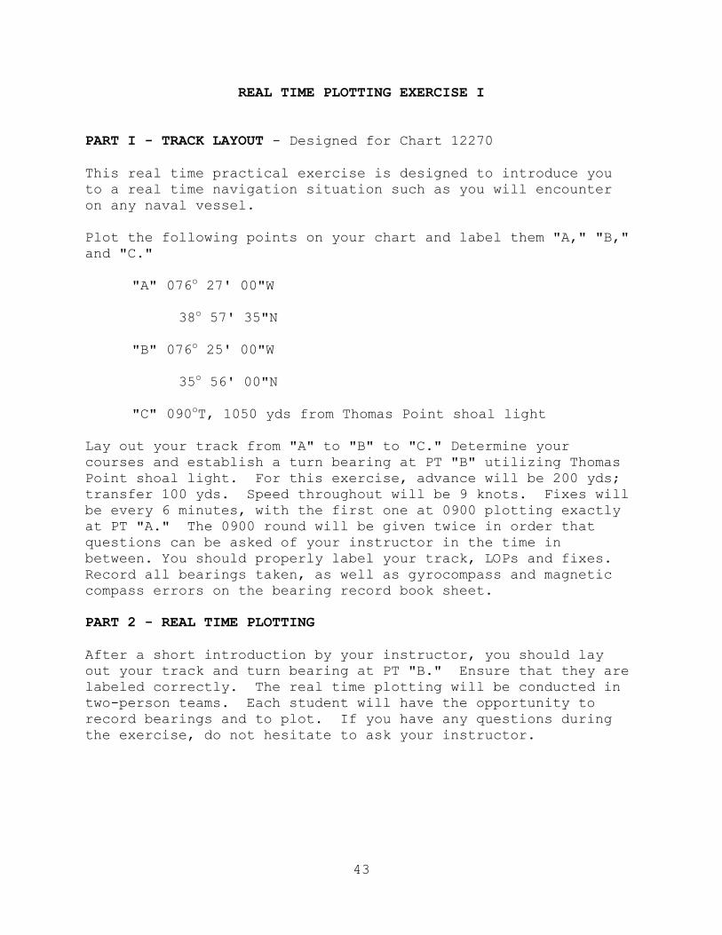
REAL TIME PLOTTING EXERCISE I
PART I - TRACK LAYOUT - Designed for Chart 12270 This real time practical exercise is designed to introduce you to a real time navigation situation such as you will encounter on any naval vessel. Plot the following points on your chart and label them "A," "B," and "C." "A" 076o 27' 00"W 38o 57' 35"N "B" 076o 25' 00"W 35o 56' 00"N "C" 090oT, 1050 yds from Thomas Point shoal light Lay out your track from "A" to "B" to "C." Determine your courses and establish a turn bearing at PT "B" utilizing Thomas Point shoal light. For this exercise, advance will be 200 yds; transfer 100 yds. Speed throughout will be 9 knots. Fixes will be every 6 minutes, with the first one at 0900 plotting exactly at PT "A." The 0900 round will be given twice in order that questions can be asked of your instructor in the time in between. You should properly label your track, LOPs and fixes. Record all bearings taken, as well as gyrocompass and magnetic compass errors on the bearing record book sheet. PART 2 - REAL TIME PLOTTING After a short introduction by your instructor, you should lay out your track and turn bearing at PT "B." Ensure that they are labeled correctly. The real time plotting will be conducted in two-person teams. Each student will have the opportunity to record bearings and to plot. If you have any questions during the exercise, do not hesitate to ask your instructor.
44
NAVAL RESERVE OFFICERS TRAINING CORPS NAVIGATION I
LESSON GUIDE: 15 HOURS: 1 TITLE: Voyage Planning and Time I. Learning Objectives A. The student will apply correct procedures to determine zone time for specific locations. B. The student will apply correct procedures to determine zone time at another location, if zone time is known at a given location. C. The student will apply correct procedures to convert longitude or arc units into equivalent time units. D. The student will comprehend the process of planning for an extended ocean voyage and the services and publications that can be of assistance during voyage planning. E. The student will comprehend the procedures for plotting a great circle route on a gnomonic projection, transferring the track to a mercator projection, and labeling the track appropriately. II. References and Texts A. Instructor references
1. Marine Navigation, Hobbs, Chapter 15 2. Dutton's Navigation and Piloting, Maloney,
Chapters 22, 4l
3. American Practical Navigator, Bowditch, Chapters 18, 23
4. COMNAVSURFLANT/COMNAVSURPAC/COMNAVAIRPAC/ COMNAVAIRLANT Instruction 3530.4, Subj: Navigation Standards and Procedures 5. Marine Navigation Workbook
45
B. Student texts 1. Marine Navigation, Hobbs, Chapter 15 2. Marine Navigation Workbook III. Instructional Aids A. Chalkboard B. Great Circle Sailing Chart: North Atlantic (number 17) C. North Atlantic Ocean Chart (number 120) D. Time zone chart of the world (number 76) E. Plotting instruments F. PowerPoint Slides G. Transparency of Arc/Time Conversion Table from Nautical Almanac IV. Suggested Methods and Procedures A. Method options: Lecture/Demonstration B. Procedural and student activity options 1. Complete assigned reading 2. Complete assigned workbook exercises V. Presentation A. Develop the concept of time zones. 1. Define and discuss a. Zone time b. Greenwich Mean Time c. Zone description d. International Date Line
46
2. Explain the correlation between zone time indicators and zone descriptions. 3. Demonstrate, through the use of examples, how to perform time conversion from zone time at one location to zone time at a second location, including daylight savings time considerations. 4. Explain how clocks are advanced and retarded. a. Advanced during the mid-watch (0000-0400) b. Retarded during the second dog watch (1800-2000) B. Review date-time group (DTG) format. C. Arc/Time conversion 1. Explain and discuss. 2. Work practical examples of conversion (arc to time and vice versa). D. Discuss the general preparation involved in planning a ship’s movement. COMNAVSURFLANT/COMNAVSURFPAC/ COMNAVAIRLANT/COMNAVAIRPAC Instruction 3530.4, Navigation Standards and Procedures, provides a good format for presentation. E. Review the use of publications and charts in voyage planning. F. Explain the planning invo1ved in plotting the intended track. 1. Discuss the use of Optimum Track Ship Routing (OTSR) and the chart and fix expansion factors that should be included in filing a request for OTSR. 2. Discuss the use of MOVREPS in conjunction with an OTSR. 3. Demonstrate plotting a great circle route on a gnomonic projection.

47
4. Transfer the track to a mercator projection chart and label it.
5. Discuss course and speed considerations. a. Explain the need to consider and avoid hazards to navigation using aids to navigation and through the plotting of danger bearings. b. Discuss the need to consider fuel economy. c. Explain the determination of ETD and ETA. d. Discuss the concepts of position of intended movement (PIM).
48
NAVAL RESERVE OFFICERS TRAINING CORPS NAVIGATION I
LESSON GUIDE: 16 HOURS: 1 TITLE: Celestial Coordinate Systems I. Learning Objectives A. The student will know the ultimate goal of celestial navigation. B. The student will know the definitions of terms and components associated with the celestial and horizon systems of coordinates. C. The student will know the relationship between the terrestrial, celestial, horizon, and the coordinate systems. D. The student will apply correct procedures to describe
the location of a celestial body in reference to the celestial and horizon coordinate systems.
Instructor Note: Lessons 16-19 are intended to introduce students to the basic concepts of celestial navigation. Lessons 16 and 17 enable the student to understand the theory of celestial navigation. Lesson 18 allows the student to see how the solution of the navigational triangle leads to an LOP on a chart. Lesson 19 informs the student of the various information that can be obtained from the practice of celestial navigation. II. References and Texts A. Instructor references
1. Marine Navigation, Hobbs, Chapter 16 2. Dutton’s Navigation and Piloting, Maloney,
Chapters 18, 19 3. American Practical Navigator, Bowditch, Chapter 14 4. Marine Navigation Workbook B. Student texts
49
1. Marine Navigation, Hobbs, pp. 277-289 2. Marine Navigation Workbook III. Instructional Aids A. PowerPoint Slides B. Slate globe (optional) C. Chalkboard D. Video 25484DN: “Basic Celestial Concepts Theory” (12 min.) E. Celestial navigation sphere (Device 1A24) F. VCR/Monitor G. Rigid plane, such as a desk blotter holder or thin plywood (approximately 2’x 2’) H. Chalk compass/Divider I. Computer-aided instruction: CELNAV (optional) IV. Suggested Methods and Procedures A. Method options 1. Video 2. Lecture B. Procedural and student activity options 1. Complete assigned reading 2. Complete assigned workbook exercises V. Presentation A. Review of the terrestrial coordinate system 1. Terminology a. Poles
50
b. Equator c. Greenwich meridian (prime meridian) d. Latitude e. Longitude f. Great circle g. Parallel h. Meridian 2. Measurement: 1 minute of arc measured along a meridian, or other great circle on the earth, equals one nautical mile. B. Introduce concept of celestial navigation. 1. Explain that the ultimate goal of celestial navigation is the solution of spherical triangles to determine the position of a craft or vessel with respect to earth-oriented coordinates (latitude and longitude). 2. Logical extension of the basic problem of fixing a ship’s position 3. Celestial LOPs are plotted in a manner similar to terrestrial LOPs. 4. Remainder of celestial navigation will be concerned with how these celestial LOPs are obtained. 5. Assumption: Earth is fixed; celestial bodies move about the earth in a predicable pattern. 6. Celestial sphere: Celestial bodies are assumed to be on the surface of a vast hollow sphere of infinite radius with the center of the earth as its center. C. Celestial equator system of coordinates
51
1. Projection of terrestrial system outward to celestial sphere. 2. Define and discuss the following terminology: a. Celestial equator (equinoctial) b. Celestial meridians c. Greenwich celestial meridian d. Celestial poles e. Hour circles (1) Local hour circle (2) Hour circle of Aries (3) Greenwich hour circle f. Hour angles: GHA, SHA, LHA g. Meridian angle (t) h. Declination i. Geographic position (GP) j. Diurnal circle k. Polar distance D. Horizon system of coordinates 1. Based on position of observer; no two people share the same horizon or zenith/nadir at the same time. 2. Define and discuss terminology. a. Assumed position b. Celestial horizon c. Zenith/Nadir d. Prime vertical circle
52
e. Principal vertical circle f. Altitude g. Co-altitude h. True azimuth i. Azimuth angle E. Explain that these three systems will be combined to form the navigation triangle, the basis for celestial navigation. F. The navigation software CELNAV provides an excellent multicolored graphics presentation on the terrestrial, celestial and horizon coordinate systems. G. Supplemental information: The following matrix is
recommended for instructor use.
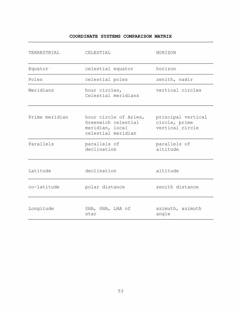
53
COORDINATE SYSTEMS COMPARISON MATRIX
TERRESTRIAL CELESTIAL HORIZON Equator celestial equator horizon Poles celestial poles zenith, nadir Meridians hour circles, vertical circles Celestial meridians Prime meridian hour circle of Aries, principal vertical Greenwich celestial circle, prime meridian, local vertical circle celestial meridian Parallels parallels of parallels of declination altitude Latitude declination altitude co-latitude polar distance zenith distance Longitude SHA, GHA, LHA of azimuth, azimuth star angle
54
NAVAL RESERVE OFFICERS TRAINING CORPS NAVIGATION I
LESSON GUIDE: 17 HOURS: 1 TITLE: Navigational Triangle I. Learning Objectives A. The student will comprehend the interrelationships of the terrestrial, celestial, and horizon coordinate systems in defining the navigation triangle. B. The student will gain a working knowledge of the celestial and navigational triangles. II. References and Texts A. Instructor references 1. Marine Navigation, Hobbs, Chapter 16 2. Dutton’s Navigation and Piloting, Maloney, Chapter 19 3. American Practical Navigator, Bowditch, Chapter 14 4. Marine Navigation Workbook B. Student texts 1. Marine Navigation, Hobbs, pp. 289-295 2. Marine Navigation Workbook III. Instructional Aids A. PowerPoint Slides B. Slate globe (optional) C. Chalkboard D. Celestial navigation sphere (Device 1A24) E. Chalk compass/Dividers F. Cardboard or plywood plane (approximately 2’x 2’)
55
G. Computer Aided Software: CELNAV (optional) H. VCR/Monitor IV. Suggested Methods and Procedures A. Method options: Lecture B. Procedural and student activity options 1. Complete assigned reading 2. Complete assigned workbook exercises V. Presentation A. The celestial triangle 1. Discuss how the terrestrial, celestial, and horizon coordinate systems are combined on the celestial sphere to form the celestial triangle. 2. Show how each of the three sides is taken from a different coordinate system. 3. Discuss how the length of each side is determined. 4. Discuss how the three included angles are formed, ensuring students know the names of each angle. B. The navigational triangle
1. Discuss that the solution of this triangle is the foundation of celestial navigation. Point out that sight reduction is the method by which the triangle is “solved.”
2. Briefly discuss that the solution is accomplished
using the mathematics of spherical trigonometry derived from plane trigonometry with Napier’s rule.
3. Discuss and define the following terms: a. AP (Assumed Position)
56
b. GP (Geographic Position) c. Elevated pole d. Co-latitude e. Co-altitude (zenith distance)
f. Co-declination (polar distance) NOTE: Because of the difficulty in changing from co-declination to polar distance when the declination is not the same as the elevated pole, start at the beginning by calling this
value polar distance. g. Meridian angle (t) h. Azimuth angle (Z) i. LHA j. True azimuth (Zn) k. Parallactic angle 4. Illustrate how varying values of the above terms would look as a triangle. Particularly show the relationship of meridian angle (t) to LHA, and the relationship of azimuth angle to true azimuth. 5. Discuss how this triangle takes on various shapes depending on the location of the GP and the AP. Explain how Zn is computed in each case. 6. Illustrate examples of navigation triangles with the following characteristics: Elevated Pole Declination Meridian Angle N N E N N W S S E S S W N S E S N W

57
C. The navigation software CELNAV provides an excellent multi-colored graphics representation on the navigational triangle. It has the added flexibility of allowing the instructor and student to develop his or her own triangles, solving for all factors. Instructors may wish to use CELNAV as a one-on-one tutorial program for students who have difficulty grasping the underlying concepts of Lessons 17-19.
58
NAVAL RESERVE OFFICERS TRAINING CORPS NAVIGATION I
LESSON GUIDE: 18 HOURS: 1 TITLE: Altitude-Intercept Method I. Learning Objectives A. The student will comprehend the concept of the circle of equal altitude as a line of position. B. The student will become familiar with the concepts of the circle of equal altitude. C. The student will know the altitude-intercept method of
plotting a celestial LOP. II. References and Texts A. Instructor references 1. Marine Navigation, Hobbs, Chapter 17 2. Dutton’s Navigation and Piloting, Maloney, Chapter 19 3. American Practical Navigator, Bowditch, Chapter 17 4. Marine Navigation Workbook B. Student texts 1. Marine Navigation, Hobbs, pp. 295-309 2. Marine Navigation Workbook III. Instructional Aids A. Slate globe (optional) B. Chalkboard
C. VCR/Monitor D. Video 25486DN: “Basic Celestial Concepts - Intercept
Method” (15 min.)
59
E. PowerPoint Slides F. Plywood or cardboard plane (approximately 2’x 2’) IV. Suggested Methods and Procedures A. Method options 1. Lecture 2. Video B. Procedural and student activity options 1. Complete assigned reading. 2. Complete assigned workbook exercises. V. Presentation A. Circles of equal altitude 1. Describe briefly the procedure that a navigator would employ to measure the angle of a body above the horizon. 2. Explain that this angle, Hc, must be corrected to obtain observed altitude, Ho. Ho is the angle that is used in determining circles of equal altitude and the altitude-intercept method. 3. Show how this angle is the same by definition from any place on the circle of equal altitude. 4. Show how the observer must be located somewhere along the circle in order to obtain this measurement. 5. Redefine how measurement along a great circle is equated to be 1 minute of arc = 1 nautical mile. 6. Explain that 90 degrees minus the angular measurement of altitude will yield co-altitude and by converting this complementary angle to miles, you have computed the radius of the circle or determined the length of your GP - AP line.
60
7. Explain how the intersection of two circles of equal altitude yields two possible locations and the intersection of three circles yields a fixed position. 8. Interrelate the circles of equal altitude back to the navigational triangle. B. Altitude-intercept method 1. Discuss the altitude-intercept method of plotting,
including the computation of intercept distance (a), and the use of true azimuth (Zn). Emphasize to the students that the concept involves solution of a spherical triangle with known inputs -- assumed latitude, declination, and local hour angle (LHA) -- and comparison of the derived result Hc (computed altitude) with observed data -- observed altitude (Ho).
2. A segment of the observed circle of equal altitude yields a celestial line of position, and this LOP can be plotted on the observer’s local chart in relation to the AP (assumed position) used to determine the intercept and azimuth of the body. C. Briefly discuss the determination of the assumed position (AP), Hc, and Zn. D. Demonstrate how to plot and label a celestial LOP/fix.
E. Show “Basic Celestial Concepts - Intercept Method” video and summarize.
61
NAVAL RESERVE OFFICERS TRAINING CORPS NAVIGATION I
LESSON GUIDE: 19 HOURS: 2 TITLE: Celestial Applications I. Learning Objectives A. The student will know the information that can be
obtained from the practice of celestial navigation at sea.
B. The student will know the correct procedures for computing times of sunrise and sunset.
C. The student will know the use of computer-based celestial observation sight reduction and computer-based Nautical Almanacs.
II. References and Texts A. Instructor references 1. Marine Navigation, Hobbs, Chapters 25, 26 2. Dutton's Navigation and Piloting, Maloney, Chapter 23 3. American Practical Navigator, Bowditch, Chapter 19 4. Nautical Almanac 5. Marine Navigation Workbook B. Student texts 1. Marine Navigation, Hobbs, Chapters 25, 26 2. Marine Navigation Workbook III. Instructional Aids A. Chalkboard B. Nautical Almanac C. PowerPoint Slides
62
IV. Suggested Methods and Procedures A. Method options: Lecture B. Procedural and student activity options 1. Complete assigned reading. 2. Complete assigned workbook exercises. V. Presentation
A. Briefly discuss the information contained in the Nautical Almanac.
B. Discuss the information that can be obtained from the
practice of celestial navigation at sea.
1. A celestial fix from the observation of stars, planets, and/or the moon. (The theory of this has already been covered in Lessons 17-19.)
2. A latitude line from the observation of a body at
meridian transit. a. Explain how the altitude of Polaris determines
latitude.
(1) A few small mathematical corrections from the Nautical Almanac can be applied to align Polaris with the North Pole.
(2) Polaris’ alignment with the North Pole
collapses the navigational triangle. The co-latitude and co-altitude sides are the same length, so Polaris’ altitude must equal the observer’s latitude.
b. Explain that the determination of latitude at
LAN is similar to the determination of latitude by Polaris.
(1) The celestial triangle is collapsed, but
the sun is not coincident with another corner of the navigational triangle.
63
(2) Observing the sun’s altitude and obtaining its declination from the Nautical Almanac allows the observer to determine latitude.
(3) Illustrate how latitude can be obtained
using one or more of the three possible meridian transit relationships between the observer and sun during a LAN observation.
(a) The sun’s GP is located on the upper
branch of the observer’s meridian between the observer and the equator.
(b) The sun’s GP is on the upper branch
of the observer’s meridian but in the opposite hemisphere from the observer.
(c) The sun’s GP lies on the upper
branch of the observer’s meridian between the observer and the elevated pole.
3. Gyro error
a. Explain how a Polaris azimuth sight provides compass error.
b. Explain how a sun azimuth sight provides
compass error.
(1) Briefly discuss the amplitude method at sunrise or sunset.
(a) Use a simple sunrise example.
(b) Assume the observer is at 10N
latitude and that the sun has a declination of N20. The observer knows that they should see the sun at 060T [90-(20+10)]. Any deviation from 060T is the result of gyro error.
64
(2) Briefly discuss the exact azimuth method.
(a) The sun does not have to be observed during sunrise or sunset.
(b) The true azimuth of the sun can be
observed, then compared to a calculated value derived from information contained in the Nautical Almanac. Any difference is due to gyro error.
(3) Explain the procedure for computing the time of sunrise and sunset.
(a) Discuss the location of sunrise and
sunset information in the Nautical Almanac.
(b) Work a sample problem to demonstrate
the method for determining the zone time of sunrise/sunset at a given location.
C. Discuss the use of computer-based celestial observation
sight reduction and computer-based Nautical Almanacs in the Navy today.
65
NAVAL RESERVE OFFICERS TRAINING CORPS NAVIGATION I
LESSON GUIDE: 20 HOURS: 1 TITLE: Electronic Navigation I. Learning Objectives A. The student will comprehend the theory and basic operating principles of radar navigation to include: Global Positioning System (GPS), Inertial Navigation System (INS), Navigation Satellite (NAVSAT) system, Navigation Sensor System Interface (NAVSSI), and bottom contour navigation. B. The student will know the importance of correcting for differences between the GPS/NAVSSI and navigation chart datum. II. References and Texts A. Instructor references 1. Marine Navigation, Hobbs, Chapters 30 and 31 2. Dutton's Navigation and Piloting, Maloney,
Chapters 34-37
3. American Practical Navigator, Bowditch, Chapters 44-46
B. Student texts 1. Marine Navigation, Hobbs, Chapters 30, 31 2. Marine Navigation Workbook III. Instructional Aids A. Chalkboard B. Bottom contour chart C. PowerPoint Slides IV. Suggested Methods and Procedures
66
A. Method options: Lecture B. Procedural and student activity options: Complete assigned reading V. Presentation A. NAVSAT satellite navigation 1. Explain the principles of doppler shift as applicable to satellite navigation. 2. Discuss the components and operation of the NAVSAT system. 3. Discuss the accuracy of the NAVSAT system. B. NAVSTAR GPS (Global Positioning System) 1. Explain how pseudoranges are used to determine position. 2. Discuss the components of the GPS system. 3. Discuss the accuracy of the GPS system and correcting for differences with navigation chart datum. 4. Discuss military applications of GPS to include navigation. C. Inertial navigation
1. Discuss the Inertial Navigation System's (INS) ability to provide continuous dead reckoning and indication of velocity and altitude.
2. Discuss the components of INS. a. Gyroscopes b. Accelerometers c. Computer/Processor 3. Discuss the factors that affect INS accuracy.
67
D. Navigation Sensor System Interface (NAVSSI) 1. Discuss NAVSSI’s ability to use all available navigation information to determine ship’s position. 2. Discuss the accuracy of NAVSSI and correcting for differences with navigation chart datum.
3. Discuss the fact that NAVSSI can send navigation information to various ship systems.
a. Tomahawk
b. JOTS
c. Outboard
4. Discuss the fact that NAVSSI will ultimately replace paper charts with digital.
5. Discuss the tasks that NAVSSI software will be able to perform.
a. Tide and current
b. Set and Drift 6. Bathymetric navigation a. Discuss the use of bottom contour charts and echo soundings to establish ship’s position. b. Discuss the components and basic operation of the fathometer. c. Discuss the factors that affect the accuracy of the bathymetric navigation DR plot.
68
NAVAL RESERVE OFFICERS TRAINING CORPS NAVIGATION I
LESSON GUIDE: 21 HOURS: 1 TITLE: Weather I. Learning Objectives
A. The student will know the principles of basic weather phenomena, including fronts and subtropical and tropical storms.
B. The student will know the relationship between wind and
current in a wind-driven current system.
C. The student will know the earth’s major wind and current systems.
D. The student will know how wind velocities relate to
storm warnings and their effects on sea state.
E. The student will know the sources of environmental predictions, including pilot charts and weather broadcasts.
F. The student will know the characteristics of the
approach of tropical storms and hurricane/typhoon evasion techniques.
II. References and Texts A. Instructor references
1. American Practical Navigator, Bowditch, Chapters 37, 38
2. Weather for the Mariner, Kotsch, pp. 31-71, 21-127, 137-168, 185-196 3. Surface Ship Operations, pp. 75-104 4. Watch Officer's Guide, p. 185 and Appendix B B. Student text: Surface Ship Operations, pp. 75-104 III. Instructional Aids
69
A. Pilot charts
B. Projector
D. Chalkboard
E. Video 25488DN: "Meteorology (Hurricanes)", 1971
(25 min.)
F. VCR/Monitor IV. Suggested Methods and Procedures A. Method options 1. Lecture 2. Video B. Procedural and student activity options: Complete
assigned reading. V. Presentation A. Weather: Basic systems 1. Discuss the causes of and the general air flow around the planet. Discuss the development of permanent pressure areas and constants such as trade winds. 2. Discuss the development, movement, and winds associated with high and low pressure systems. 3. Discuss the formation, movements, and weather associated with weather fronts. 4. Discuss the general storm conditions associated with weather fronts. 5. Discuss the formation of clouds and the significance of different types of cloud formations. 6. Discuss the relationship between wind and current in wind-driven current systems.
70
7. Identify the earth’s major wind and current
systems. 8. Discuss the sources of environmental predictions, including pilot charts and weather broadcasts. B. Tropical storms 1. Discuss how wind velocities relate to storm warnings and their correlation to sea states (Beaufort Scale). 2. Discuss the development of tropical cyclones and the sustaining factors of the storm. Discuss the locations and frequencies of these storms. 3. Define the following terms: a. Dangerous semicircle b. Navigable semicircle C. Crossing the "T" C. Hurricane/Typhoon evasion 1. Discuss the best maneuvering procedures for very
heavy seas. 2. Discuss the best maneuvering procedures to avoid storm effects based on the ship's position in relation to the storm. 3. Discuss a ship’s heavy weather bill and proper
safety precautions during heavy weather conditions.
D. Show “Meteorology (Hurricanes)” video and summarize.
71
C. NAVAL RESERVE OFFICERS TRAINING CORPS NAVIGATION I
LESSON GUIDE: 22 HOURS: 2 TITLE: “The USS Gonzalez (DDG-66) Grounding” Case Study I. Learning Objectives A. The student will comprehend the responsibility of naval officers to ensure the safety of their ships and crews. B. The student will comprehend the leader's importance of responsibility and accountability at all levels in the chain of command. C. The student will comprehend the value of a thorough
Navigation Brief. D. The student will be able to identify poor watchstanding
and navigation practices and ways to eliminate them in his or her efforts to prevent grounding a vessel.
E. The student will comprehend the importance of
information feedback to mission effectiveness. II. References and Texts A. Instructor reference: "USS Gonzalez (DDG-66)
Grounding" Case Study (Appendix B) B. Student text: "USS Gonzalez (DDG-66) Grounding" Case
Study (Appendix B/Handout) III. Instructional Aids A. Course syllabus B. Chalkboard C. Easel/Overhead projector IV. Suggested Methods and Procedures A. Method options: Discussion
72
B. Procedural and Student Activity Options: Complete assigned reading.
V. Presentation A. Define accountability/responsibility as: Liable to be
called on to answer; able to answer for one’s conduct and obligations.
B. Lead a discussion relating the above points to the USS
Gonzalez case study. It is the students' job to analyze the conduct of the CO, NAV, OOD, and other watchstanders onboard the grounded destroyer.
1. Discuss the responsibilities of the OOD.
a. What are the responsibilities of the OOD? b. In what ways did the OOD fail to meet these
responsibilities?
(1) The OOD failed to make himself aware of the geographic factors that might affect safe navigation of the ship.
(2) The OOD failed to supervise personnel on watch on the bridge to ensure their performance was within expected standards.
(3) The OOD failed to review the chart in use and failed to ensure that a present and projected ship’s position were determined to a reasonable degree.
c. What factors affected the OOD’s decision-
making process? (1) Difficulties in stowing the ship’s ladder
and casting off the CHT barge forced a late underway (0818 vice 0800). Consequently, the changed contact situation forced the ship to alter its intended underway track.
(2) A poor navigation brief failed to discuss
all navigation hazards within the
73
vicinity of USS Gonzalez, which caused the OOD to make decisions without knowledge or regard for Proselyte Reef.
(3) Conflicting reports from the navigator.
2. Discuss the responsibilities of the other watchstanders.
a. What were the responsibilities the CIC watch team?
(1) The CIC watch team failed to keep the OOD
advised of navigational hazards.
(2) The CIC officer failed to keep himself apprised of the status of the navigation evolution as he was preoccupied with preparations for upcoming events.
b. In what ways did the leading quartermaster and
CIC watch team fail to meet their responsibilities?
3. Discuss the responsibilities of the navigator. a. What were the responsibilities of the
navigator?
b. In what ways did he fail to meet these responsibilities?
(1) The NAV failed to maintain an accurate
plot of ship’s position by any means.
(2) The NAV failed to ensure a ship’s DR was plotted.
(3) The NAV failed to give proper attention to the course of the ship and the depth of the water as it approached Proselyte Reef.
(4) The NAV failed to reconcile differences between the CIC and bridge plots.
(5) The NAV failed to advise the OOD of a safe course to steer.
74
(6) The NAV failed to highlight or discuss all shoal water in the vicinity of the ship during the navigation brief.
4. Discuss the responsibilities of the commanding officer. a. What were the responsibilities of the
commanding officer?
b. In what ways did he fail to meet these responsibilities? (The CO failed to ensure the safe navigation of the ship.)
5. Who should be held accountable for the grounding?
6. Does the navigator’s failure to make proper reports or the officer of the deck’s failure to adequately perform his duties affect the commanding officer’s ultimate accountability?
7. Does a navigator’s report that “course 180 is a good course, I concur with course 180,” absolve the OOD’s responsibility for standing the ship into danger if course 180 grounds the ship? Keep in mind that the Navigator is an experienced Surface Warfare qualified officer and that the Navigator can relieve the OOD if he feels the OOD is driving the ship without regard for navigational safety.
75
NAVAL RESERVE OFFICERS TRAINING CORPS NAVIGATION I
LESSON GUIDE: 23 HOURS: 1 TITLE: Purpose and Scope of International and Inland Rules I. Learning Objectives A. The student will comprehend the purpose and significance of both the International and Inland Rules of the Road. B. The student will know the terminology associated with the Rules of the Road. C. The student will comprehend the benefits of case analysis of actual groundings, collisions, storm damage, and shipboard accidents and know the publications where such information may be found. II. References and Texts A. Instructor references 1. Navigation Rules, COMDTINST M16672.2D
2. A Mariner's Guide to the Rules of the Road, Tate
3. Farwell's Rules of the Nautical Road B. Student text: Navigation Rules, COMDTINST M16672.2D,
pp. vi-11 III. Instructional Aids
A. Video 23582DN: "The Halifax Incident", 1942 (7 min.) Video 23601DN: "Svea/Newport Incident", 1943 (5 min.)
B. Chalkboard
C. Rules of the Road Slide Presentation. This slide program is an excellent training aid for Rules of the Road throughout this series of lesson guides. Take note of the slide numbering system; slide numbers correspond with the rule number to which they refer.
76
These slides are also useful for testing student comprehension.
D. VCR/Monitor
E. PowerPoint Slides
IV. Suggested Methods and Procedures A. Method option: Lecture 1. Prior to the first lesson on Rules of the Road,
instructors are encouraged to review all available training aids to reinforce their understanding and to provide students with the most recent information and court rulings.
2. Present videos at appropriate times (optional). 3. Assign each student to review a case analysis of a marine disaster. Review the sources of such
information, such as Surface Warfare magazine, Naval Institute Proceedings, and National Transportation Safety Board (NTSB) findings. Many
sources may be found in unit libraries, and NTSB publications may be found in the government documents section of the university library. The following are good illustrative NTSB cases:
a. Coast Guard Cutter Blackthorn and tank ship
Capricorn b. MV Starlight and USS Francis Marion c. SS Exxon Chester and MV Royal Sword d. SS Santa Cruz II and Coast Guard Cutter
Cuyahoga e. MV World Nobility and SS Pennsylvania Getty f. SS Yellowstone and MV Ibn Batouta g. U.S. Geological Survey Vessel Don J. Miller II
and FV Welcome
77
B. Procedural and student activity options: Complete assigned reading. V. Presentation A. Discuss Rules of the Road 1. Purpose: To provide a uniform guide of rules for
all mariners to follow. 2. Importance (prevent collision, prevent loss of
life, etc.) 3. Difference between the COLREGS and Unified Rules as determined by boundaries described in Navigation Rules 4. General rules B. Discuss terms applicable to Rules of the Road 1. Court interpretation and jurisdiction 2. Legal personality of a vessel 3. Doctrine of responsibility 4. Limited liability
78
NAVAL RESERVE OFFICERS TRAINING CORPS NAVIGATION I
LESSON GUIDE: 24 HOURS: 3 TITLE: International and Inland Lights and Day Shapes I. Learning Objectives A. The student will know the lights and day shapes required to be shown by the different types and classes of vessels operating in: 1. Waters where the international "Collision Regulations" apply. 2. Waters covered by the Inland Rules of the United States. B. The student will know the various signals which may be used in inland or international waters by vessels to indicate they are in distress and require assistance. II. References and Texts A. Instructor references
1. Navigation Rules, COMDTINST M16672.2D
2. A Mariner's Guide to the Rules of the Road, Tate
3. Farwell's Rules of the Nautical Road B. Student text: Navigation Rules, COMDTINST M16672.2D,
Rules 20-31, 36-37 III. Instructional Aids
A. Rules of the Road Slide Presentation
B. Video 23588DN: "City of Rome Incident", 1942 (5 min.)
C. Slide Projector
D. Chalkboard
79
F. Rules of the Road, Flash Cards, NAVEDTRA 10925
G. Computer-Aided Software: Rules of the Nautical Road (optional)
H. IBM-compatible personal computer (optional)
I. PowerPoint Slides
J. VCR/Monitor
IV. Suggested Methods and Procedures A. Method options 1. Completely present the International lights and shapes in each section and then present the Inland differences using the slide presentation. 2. Present video at appropriate time (optional). The "City of Rome Incident" examines the collision of a freighter (City of Rome) and a U.S. submarine in 1933. Thirty-seven sailors lost their lives as a result. This collision reinforces the proper placement of masthead and side lights and is the basis for the special submarine light in use today. The collision resulted from the ambiguity caused by physical placement of the submarine's navigational lights. B. Procedural and student activity options: Complete
assigned reading. V. Presentation (Lesson I) A. Definition of terms. Define terms in accordance with
Navigation Rule #3: vessels, underway, restricted visibility, etc.
B. Lights (Rules 20, 21, 22) 1. Describe the required navigational lights. a. Reason for displaying (Rule 20) b. When to display present International and
Inland Rules together (Rule 20)
80
c. Location (Rule 21) d. Arc of visibility (Rule 21) e. Distance/Range of visibility (Rules 21, 22) f. Length of ship (Rule 22) 2. Discuss the lights required by the following vessels. Use the slide presentation for reinforcement. a. Power-Driven Vessels Underway (Rule 23) b. Towing and Pushing (Rule 24) (1) Astern (including length of tow) (2) Composite Units (3) Vessels or objects being towed c. Sailing Vessels Underway and Vessels Under
Oars (Rule 25) d. Fishing & Trawling Vessels (Rule 26) e. Vessels Not Under Command or Restricted in Ability to Maneuver (Rules 27, 28) f. Vessels at Anchor (Rule 27) VI. Presentation (Lesson II) A. Lights (continued) 1. Briefly review light terms and characteristics presented in previous lessons. 2. Continue discussion of lights required by the following vessels. Use the slide presentation for reinforcement. a. Mine sweepers (Rule 27) b. Constrained by draft (Rule 28)
81
c. Pilot vessels (Rule 29) d. Anchored (include length of ship) (Rule 30) e. Aground (include length of ship) (Rule 30) f. Submarines g. Vessels not under command (Rule 27) h. Non-displacement craft (Rule 23) i. Law enforcement vessels B. Dayshapes 1. Describe the dayshapes in terms of: a. Location b. Color 2. Discuss the dayshapes exhibited to show status of the vessel and identify the dayshapes for applicable vessels. C. Distress signals, etc. -- Identify and discuss the
following: 1. Signals to attract attention (Rule 36) 2. Distress signals (Rule 37) 3. Additional light and sound signals (Rule 37)
NOTE: As each difference between Inland and International Rules is encountered, discuss and clarify in class. VII. Rules of the Road Slide Program (Rules 21-37) A. Lesson III (Part A) Rule 20: Slide 94 Rule 21: Slides 364, 89 Rule 22: Slides 95, 365, 99 Rule 23: Slides 104, 100, 102, 203, 373,109

82
Rule 24A: Slides 383, 384, 428 Rule 24B: Slide 377 Rule 24D: Slides 379, 386, 378 Rule 24F: Slides 380, 381 Rule 25: Slides 375, 376 Rule 26: Slides 394, 426 B. Lesson III, Part B Rule 27A: Slides 402, 403 Rule 27B: Slides 396, 395 Rule 27C: Slide 398 Rule 27D: Slides 399, 221 Rule 27E: Slide 401 Rule 28: Slides 415, 413 Rule 29: Slides 409, 410 Rule 30: Slides 405, 406, 407, 408 Rule 31, 32, 33: No slides Rule 34: Slides 438, 439, 440, 441 Rule 36, 37: Slide 463 Submarine Slide 411, Day Shapes Review Slide 417
83
NAVAL RESERVE OFFICERS TRAINING CORPS NAVIGATION I
LESSON GUIDE: 25 HOURS: 3 TITLE: Steering and Sailing Rules I. Learning Objectives A. The student will apply the Navigation Rules to deter own ship’s vessel responsibility and "right of way" in approach situations. B. The student will comprehend the provisions of the Navigation Rules which govern the navigation of vessels operated in sight of one another. C. The student will comprehend the provisions of the Navigation Rules which apply to the navigation of vessels in any condition of visibility. D. The student will comprehend the provisions of the Navigation Rules which govern the navigation of vessels in restricted visibility. E. The student will know the requirements of the Navigation Rules sound signals for all classes of vessels in all conditions of visibility. II. References and Texts A. Instructor references 1. Navigation Rules, COMDTINST M16672.2D
2. A Mariner's Guide to the Rules of the Road, Tate 3. Farwell's Rules of the Nautical Road B. Student text: Navigation Rules, COMDTINST M16672.2D, pp. 12-37 III. Instructional Aids A. Rules of the Road Slide Presentation
84
B. Slide Projector C. Chalkboard D. Overhead projector
E. Video 23605DN: "The Beaver/Selja Incident,” 1943 (5 min.) (optional)
F. Video 34406DN: "Melbourne/Evans Incident - I Relieve
You Sir,” 1975 (35 min.) (optional)
G. VCR/Monitor H. PowerPoint Slides IV. Suggested Methods and Procedures A. Method options 1. Lecture/Discussion 2. It is recommended the first hour cover the rules for navigation in any visibility condition. The second hour should cover restricted visibility navigation rules. The third hour should cover vessel navigation in sight of one another and sound signals. B. Procedural and student activity options: Complete
assigned reading. V. Presentation A. Present the rules which apply to vessels being operated in all conditions of visibility (Navigation Rules). 1. Applicability of the rules (Rule 4) 2. Proper lookout (Rule 5) 3. Safe speed (Rule 6) 4. Risk of collision (Rule 7) 5. Action to avoid collision (Rule 8)
85
6. Navigation in narrow channels (Rule 9) 7. Navigation in traffic separation schemes (Rule 10) 8. If time permits, show optional video: "Melbourne/Evans Incident--I Relieve You Sir." B. Conduct of vessels navigating in restricted visibility (Rule 19)
1. Discuss the definition of restricted visibility.
2. Define the term "safe speed."
3. Discuss sound signals for vessels navigating in restricted visibility (Rule 35).
4. Discuss requirements for proper lookouts and use
of radar.
5. The optional video 23605DN, "The Beaver/Selja Incident," may be presented in this segment. Although the rules discussed have been superseded, the video presents excessive speed and failure to take proper action on hearing a fog signal forward of the beam. Note that the video's treatment of legal damage assessments following the collision is obsolete. Be sure to emphasize the present day "comparative negligence" ruling as discussed in the Mariners Guide, page 6.
C. Discuss the rules for navigating vessels in sight of one another (Navigation Rules). 1. Sailing vessels (Rules 12) 2. Overtaking situation (Rule 13) 3. Head-on situation (Rules 14) 4. Crossing Situation (Rule 15) 5. The actions of give-way and stand-on vessels (Rules 16, 17) D. Sound signals required (Navigation Rules)
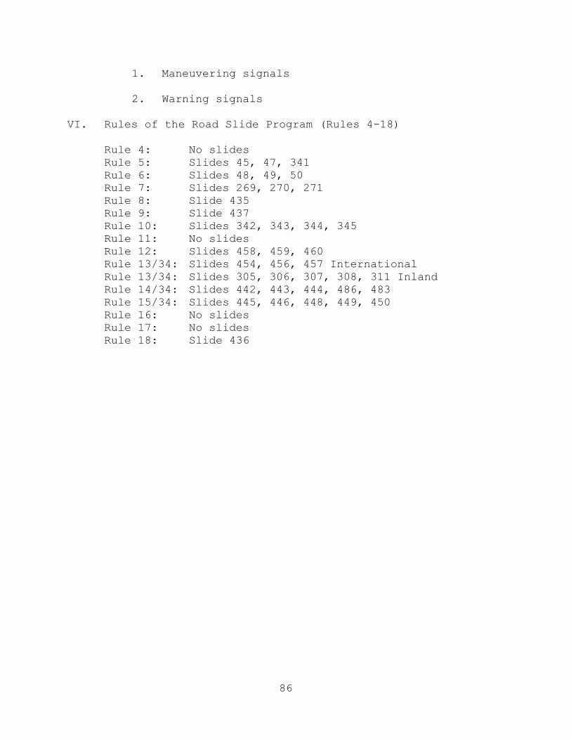
86
1. Maneuvering signals 2. Warning signals VI. Rules of the Road Slide Program (Rules 4-18) Rule 4: No slides Rule 5: Slides 45, 47, 341 Rule 6: Slides 48, 49, 50 Rule 7: Slides 269, 270, 271 Rule 8: Slide 435 Rule 9: Slide 437 Rule 10: Slides 342, 343, 344, 345 Rule 11: No slides Rule 12: Slides 458, 459, 460 Rule 13/34: Slides 454, 456, 457 International Rule 13/34: Slides 305, 306, 307, 308, 311 Inland Rule 14/34: Slides 442, 443, 444, 486, 483 Rule 15/34: Slides 445, 446, 448, 449, 450 Rule 16: No slides Rule 17: No slides Rule 18: Slide 436
87
NAVAL RESERVE OFFICERS TRAINING CORPS NAVIGATION I
LESSON GUIDE: 26 HOURS: 1 TITLE: International COLREGS/U.S. Inland Rules Differences/ Special Circumstances and Review I. Learning Objectives A. The student will know the main points of difference between the International Collision Regulations and the U.S. Inland Rules. B. The student will comprehend the situations that are governed by the rule of special circumstances. C. The student will know the requirements associated with
the Bridge-to-Bridge Radiotelephone Act. II. References and Texts A. Instructor references
1. Navigation Rules, COMDTINST M16672.2D
2. A Mariner's Guide to the Rules of the Road, Tate
3. Farwell's Rules of the Nautical Road
B. Student text: Navigation Rules, COMDTINST M16672.2D,
Rules 1-38 and Appendices, Bridge-to-Bridge Radiotelephone Regulations
III. Instructional Aids A. Chalkboard B. PowerPoint Slides IV. Suggested Methods and Procedures A. Method options 1. Lecture/Discussion
88
2. Emphasis should be placed on the different meaning associated with signals given by the stand-on and give-way vessels in various approach situations. B. Procedural and student activity options: Complete
assigned reading. V. Presentation A. Responsibilities and right of way under Inland Rules 1. Explain that the primary difference between International and Inland Rules is the meaning of whistle signals. 2. Review the duties of stand-on and give-way vessels. 3. Explain that the only difference in the right of way between different categories of vessels is that a "vessel constrained by her draft" is not defined in Inland Rules. B. Approach situations under Inland Rules 1. Review the definition of risk of collision. 2. Discuss the three approach situations and the meaning of associated whistle signals below: a. Meeting (Rule 9) b. Overtaking (Rule 13) c. Crossing (Rule 15) 3. Explain how to resolve ambiguous situations (i.e., meeting or crossing; crossing or overtaking). C. Discuss approach evaluations as viewed on radar.
(NOTE: Review conduct of vessels in reduced visibility.) D. Review light and day shape differences between Inland and International Rules, including: 1. Differences in location and length requirements
89
2. Towing light difference (Rule 24 - Inland Rules) a. Towing astern b. Pushing ahead or towing alongside E. Discuss special circumstances not specifically addressed by the rules (refer to Mariner's Guide, pp. 62-68).
1. Situations where the vessels find themselves already in "extremis." (NOTE: "Extremis" is used in the text; however, it is no longer a recognized legal term. The court has determined that vessels should take due action to avoid situations deemed to be "in extremis.")
2. Situations where a vessel is unable to comply with
the rules through some uncontrollable circumstance.
3. Presence of more than two vessels approaching simultaneously.
4. Approach situations where the vessels have agreed
to depart from the rules.
F. Discuss the use of the bridge-to-bridge radiotelephone and the log-keeping requirements as presented in the Bridge-to-Bridge Radiotelephone Act (pp. 206-210 of Navigation Rules). G. Simulate a typical bridge-to-bridge radiotelephone transmission between a U.S. naval vessel and a merchant ship under the following circumstances: 1. Meeting 2. Crossing 3. Overtaking
90
NAVAL RESERVE OFFICERS TRAINING CORPS NAVIGATION I
LESSON GUIDE: 27 HOURS: 2 TITLE: International Law/Federal Regulations and Naval Operations I. Learning Objectives A. The student will be able to define the concept of maritime baselines. B. The student will be able to define "national waters," "international waters," "continental shelves," and "safety zones." C. The student will know the difference between "national airspace," "international airspace," and "outerspace." D. The student will know the international law status of military aircraft and ships of war. E. The student will comprehend the provisions of international law regarding navigation in and overflight of national and international waters. F. The student will be familiar with the main provisions of laws and regulations governing environmental pollution by ships. G. The student will be familiar with the U.S. Navy/Russian Federation Navy agreements to prevent incidents at sea while conducting naval exercises (INCSEA Agreement). II. References and Texts A. Instructor references
1. International Law for Seagoing Officers, Chapters 4 through 7
2. U.S. Navy Regulations, Paragraphs 0925 and 1121 B. Student texts: None III. Instructional Aids
91
A. PowerPoint Slides
B. Chalkboard C. Overhead Projector IV. Suggested Methods and Procedures A. Method options 1. Lecture
2. Guest lecturer from the university law school or from a Navy JAG reserve unit.
B. Procedural and student activity options: Lecture/Class discussion. V. Presentation A. Discuss the international law definitions and usages relating to territorial seas and the high seas. 1. In order that students understand the difference between territorial seas and international waters, the "baseline" must be defined as a reference for measurement, including a discussion of: a. Low water line b. Straight baselines c. Bays and gulfs d. River mouths e. Reefs f. Harbor works 2. Define the term "national waters" and discuss the
legal limits and privileges of national jurisdiction in national waters, including:
a. Internal waters
92
b. Territorial seas c. Archipelagic waters 3. Define "international waters" and discuss the legal jurisdictions of littoral states over international waters, including: a. Contiguous zones b. Exclusive economic zones c. High seas d. Security zones e Continental shelf f. Safety zones g. Littoral distance 4. Define and differentiate between international airspace, national airspace, and outerspace in
terms of jurisdiction. B. Discuss the status of ships and aircraft and passage rights under international law. 1. Define and discuss the status under international law of each of the following: a. Warship b. Naval auxiliary c. Merchant vessel d. Military aircraft e. Military contract aircraft f. Civilian aircraft 2. Discuss the customary international law regarding navigation within the national waters of another
93
nation and overflights of the national airspace of another nation by: a. Warships or naval auxiliaries b. Merchant vessels c. Military aircraft and military contract aircraft d. Civil aircraft 3. Define and discuss transit passage rights in international straits, including: a. Straits solely in the territorial waters of coastal nations b. Straits not completely overlapped by territorial seas 4. Define and discuss transit passage rights of military ships and aircraft in archipelagic waters, including: a. Archipelagic sea lanes passages b. Passages within other archipelagic waters 5. Discuss the status of navigation and overflight of international waters, including: a. Contiguous zone b. Exclusive economic zones c. The high seas d. Closure or warning areas e. Declared security or defense zones f. Air defense identification zones 6. Discuss the United States’ practice regarding navigation or operation of military aircraft relative to:
94
a. The polar regions b. Nuclear-free zones c. Convention on International Civil Aviation C. Define the purpose and discuss the provisions of the U.S. Navy/Russian Federation Navy agreement on the prevention of incidents on or over the high seas. 1. Ships will observe both the letter and spirit of the international rules of the road. 2. Surveillance ships will exercise good seamanship so as not to embarrass or endanger ships under surveillance. 3. Ships will utilize special signals for announcing their operational intentions. 4. Ships of one party will not simulate attacks, launch objects in the direction of, or illuminate the navigation bridges of ships of another party. 5. Ships conducting exercises with submarines shall show appropriate signals to warn of submarines in the area. 6. When approaching ships of the other party,
especially when they are engaged in replenishment or flight operations, approach ships should remain well clear.
7. Aircraft will use caution when approaching aircraft or ships of the other party. D. Discuss the duties and responsibilities of Navy ships
with respect to rescue at sea. “The Bolinao Affair” Case Study (Lesson 28) can be used to illustrate the consequences of failure to provide adequate assistance to vessels and persons in distress on the high seas.
E. Discuss the application of environmental pollution laws in the operation of naval ships, including:
95
1. Minimum distance from shore requirements for disposal of certain waste items.
a. Trash - 50 miles
b. Garbage - 12 miles
c. Sewage - 3 miles
d. Petroleum products or petroleum-contaminated
water - 50 miles
2. Reporting requirements for petroleum spills.
3. The ban on dumping plastics at sea in accordance with the 1993 International Convention for Prevention of Pollution from Ships.
4. The total ban on disposal of medical waste at sea.
96
NAVAL RESERVE OFFICERS TRAINING CORPS NAVIGATION I
LESSON GUIDE: 28 HOURS: 2 TITLE: “The Bolinao Affair” Case Study I. Learning Objectives A. The student will comprehend the responsibility of naval officers to comply with International Law. B. The student will comprehend the leader's moral and ethical responsibilities to the organization and society. C. The student will comprehend the relationship of integrity, moral courage, and ethical behavior to authority, responsibility and accountability. D. The student will comprehend the following personal qualities and be able to relate them to a leader's effectiveness: 1. Loyalty 2. Honor 3. Integrity 4. Courage (moral) E. The student will comprehend the importance of proper character development (founded in core values) as it relates to the principles of effective leadership. F. The student will comprehend the importance of information feedback to mission effectiveness. II. References and Texts A. Instructor references: "The Bolinao Affair" Case Study (Appendix B) B. Student text: "The Bolinao Affair" Case Study (Appendix B/Handout) III. Instructional Aids
97
A. Course syllabus B. Chalkboard C. Easel/Overhead projector IV. Suggested Methods and Procedures: Method Options A. Lecture B. Discussion V. Presentation A. Definition of authority, accountability, and responsibility. 1. Authority: The power to influence or command
thought, opinion, or behavior 2. Accountability: Liable to be called on to answer; able to answer for one’s conduct and obligations; synonymous with responsibility. 3. Authority can be delegated; accountability/ responsibility cannot. B. Lead a discussion relating the above points to the case
study on "The Bolinao Affair." It is the students' job to analyze the conduct of the CO, XO, and crew of the USS Dubuque.
1. Discuss the conduct of the commanding officer.
a. What were the commanding officer’s
responsibilities to the refugees according to International Law?
b. What decisions constituted a lack of proper
judgment?
c. Are there any decisions that were justifiable?
d. What factors influenced the commanding officer’s decision-making process?
(1) Mission
98
(2) Climate (What was happening in this region during 1988?)
(3) Safety of ship and crew
(4) Information from the executive officer, interpreter, and investigating team
e. Why did the commanding officer refuse help from the USNS Kilauea?
2. Discuss the conduct of the executive officer.
a. What errors were made during the boat
inspection?
b. What were the executive officer’s responsibilities as the commanding officer’s main advisor?
c. Did the executive officer have the authority
to act contrary to the commanding officer’s orders?
3. Discuss the conduct of the crew.
a. A Marine captain on the investigating team
said, “These people will die.”
b. ICFN Pham lied and told the refugees that they would be rescued in two days. He also misunderstood important information (time at sea, propulsion status, and health of refugees).
c. Crewmembers shook refugees off lines.
d. What were the responsibilities of the above
personnel?
4. Discuss who should be held accountable for this incident.
5. What significance should the commanding officer's
record have when accountability is assigned?
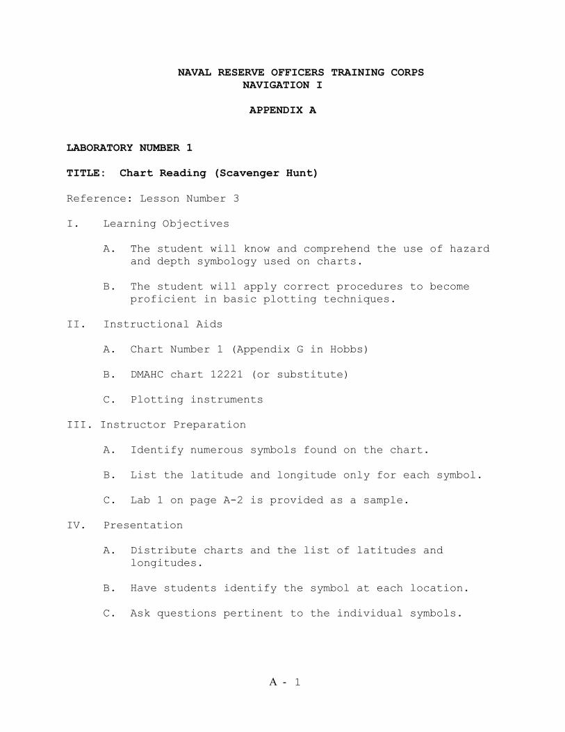
A - 1
NAVAL RESERVE OFFICERS TRAINING CORPS NAVIGATION I
APPENDIX A
LABORATORY NUMBER 1 TITLE: Chart Reading (Scavenger Hunt) Reference: Lesson Number 3 I. Learning Objectives A. The student will know and comprehend the use of hazard and depth symbology used on charts. B. The student will apply correct procedures to become proficient in basic plotting techniques. II. Instructional Aids A. Chart Number 1 (Appendix G in Hobbs) B. DMAHC chart 12221 (or substitute) C. Plotting instruments III. Instructor Preparation A. Identify numerous symbols found on the chart.
B. List the latitude and longitude only for each symbol. C. Lab 1 on page A-2 is provided as a sample.
IV. Presentation A. Distribute charts and the list of latitudes and longitudes. B. Have students identify the symbol at each location. C. Ask questions pertinent to the individual symbols.
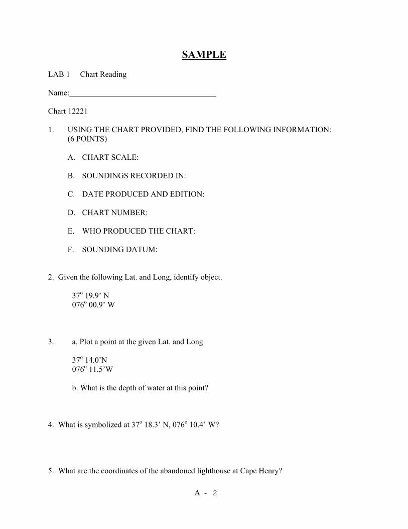
A - 2
SAMPLE LAB 1 Chart Reading Name: Chart 12221 1. USING THE CHART PROVIDED, FIND THE FOLLOWING INFORMATION:
(6 POINTS)
A. CHART SCALE:
B. SOUNDINGS RECORDED IN:
C. DATE PRODUCED AND EDITION:
D. CHART NUMBER:
E. WHO PRODUCED THE CHART: F. SOUNDING DATUM:
2. Given the following Lat. and Long, identify object. 37o 19.9’ N 076o 00.9’ W 3. a. Plot a point at the given Lat. and Long 37o 14.0’N 076o 11.5’W
b. What is the depth of water at this point? 4. What is symbolized at 37o 18.3’ N, 076o 10.4’ W? 5. What are the coordinates of the abandoned lighthouse at Cape Henry?
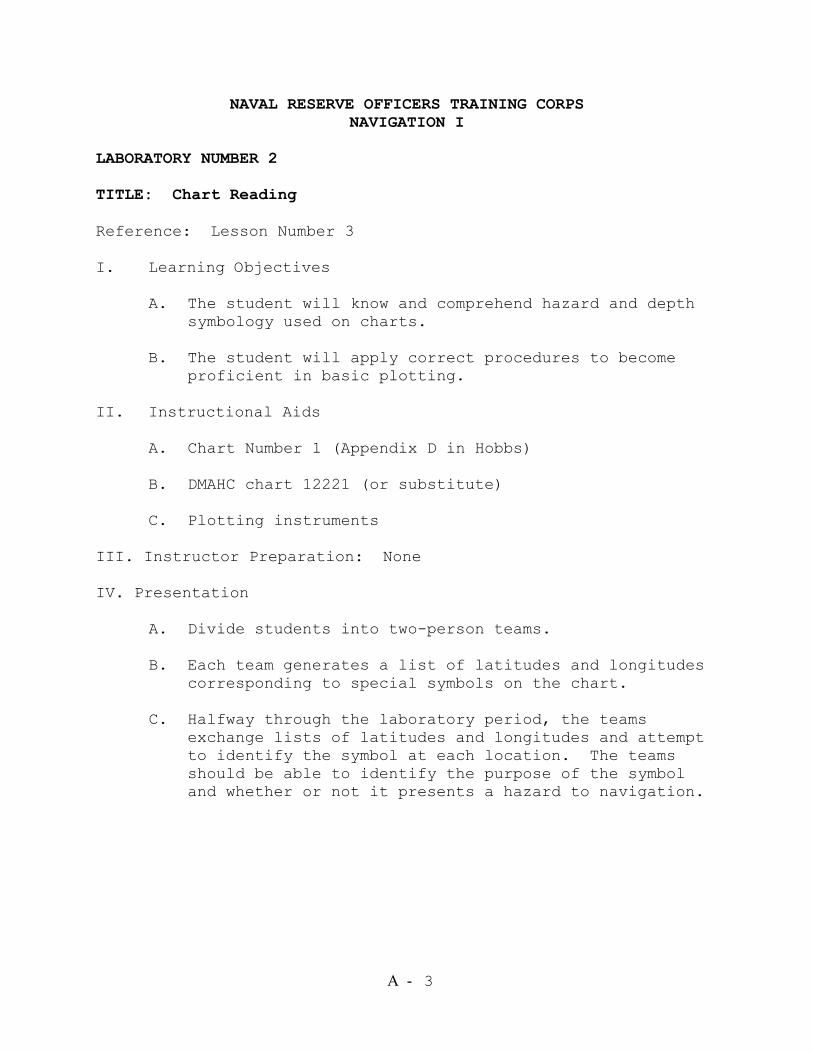
A - 3
NAVAL RESERVE OFFICERS TRAINING CORPS NAVIGATION I
LABORATORY NUMBER 2 TITLE: Chart Reading Reference: Lesson Number 3 I. Learning Objectives A. The student will know and comprehend hazard and depth symbology used on charts. B. The student will apply correct procedures to become proficient in basic plotting. II. Instructional Aids A. Chart Number 1 (Appendix D in Hobbs) B. DMAHC chart 12221 (or substitute) C. Plotting instruments III. Instructor Preparation: None IV. Presentation
A. Divide students into two-person teams.
B. Each team generates a list of latitudes and longitudes corresponding to special symbols on the chart.
C. Halfway through the laboratory period, the teams
exchange lists of latitudes and longitudes and attempt to identify the symbol at each location. The teams should be able to identify the purpose of the symbol and whether or not it presents a hazard to navigation.
A - 4
NAVAL RESERVE OFFICERS TRAINING CORPS NAVIGATION I
LABORATORY NUMBER 3 TITLE: Lights Reference: Lesson Number 4 I. Learning Objectives A. The student will know light characteristics. B. The student will apply correct procedures to become proficient in the use of the Light List. C. The student will apply correct procedures in computing
the visibility of a navigation light. II. Instructional Aids A. Excerpts from Light List, including the luminous range diagram B. Chart corresponding to above excerpt
F. Plotting instruments G. Sample Lab 3 and Computed Visibility Form
III. Instructor Preparation A. Select various lights from the chart. B. Make excerpts for each student corresponding to the above lights from the Light List. C. Develop a scenario for a problem including height of
eye and meteorological visibility. IV. Presentation A. Distribute chart and Light List excerpts.
B. Have students identify phase characteristics for each light.

A - 5
C. Have students solve for computed and luminous range and computed visibility.
D. Have students locate the light on the chart and plot
the computed visibility.
A - 6
SAMPLE
LAB 3 Lights
Name(s)_________________________ Use Chart #12221 1. What are the light characteristics of the Cape Henry Abandoned Lighthouse? 2. a. What are the characteristics of the buoy M12 in the Mobjack Bay channel?
b. What does the buoy indicate? c. What are its coordinates (Lat, Long)?
3. What are the light characteristics of the light located at 37o 15.7’ N, 076o 20.0’ W? 4. What are the light characteristics of the Old Point Comfort light at the channel entrance to Hampton Roads? 5. Using the Computed Visibility Form provided, calculate the computed visibility of Chesapeake Light. Assume meteorological visibility is 11 NM and your height of eye is 50 feet. 6. If your ship were to enter Hampton Roads, what chart would you use?
A - 7
Light’s Name: ________________________ Luminous Range: Nominal Range (from Light List): _________NM Meteorological Visibility (Given): _________NM Luminous Range (from Diagram): _________NM Computed Range: HT of Light (from Light List): __________FT HT of Eye (Given): __________FT Geographic Range of Light: ________NM Horizon Distance of Observer’s Eye: __________NM Computed Range: ____________NM Computed Visibility: Luminous Range: __________NM Computed Range: _________NM Computed Visibility: ________NM
A - 8
NAVAL RESERVE OFFICERS TRAINING CORPS NAVIGATION I
LABORATORY NUMBER 4 TITLE: Plotting Exercise (Gyroland) Reference: Lesson Numbers 6, 7, and 8 I. Learning Objective: The student will apply correct
procedures in improving plotting proficiency, particularly the plotting of Running Fixes.
II. Instructional Aids A. Gyroland chart and script or Sample Lab 4
B. Plotting instruments C. Chart 12270
III. Instructor Preparation: Make copies of Gyroland script
(attached) or Sample Lab 4 (attached). IV. Presentation A. Distribute Gyroland chart and script or Sample Lab 4. B. Students follow the script in plotting the exercise.
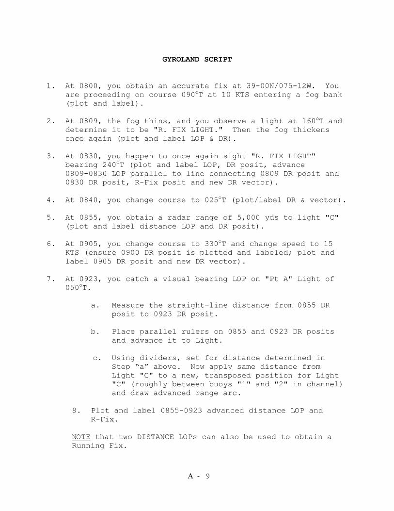
A - 9
GYROLAND SCRIPT
1. At 0800, you obtain an accurate fix at 39-00N/075-12W. You
are proceeding on course 090oT at 10 KTS entering a fog bank (plot and label).
2. At 0809, the fog thins, and you observe a light at 160oT and
determine it to be "R. FIX LIGHT." Then the fog thickens once again (plot and label LOP & DR).
3. At 0830, you happen to once again sight "R. FIX LIGHT"
bearing 240oT (plot and label LOP, DR posit, advance 0809-0830 LOP parallel to line connecting 0809 DR posit and 0830 DR posit, R-Fix posit and new DR vector).
4. At 0840, you change course to 025oT (plot/label DR & vector). 5. At 0855, you obtain a radar range of 5,000 yds to light "C"
(plot and label distance LOP and DR posit). 6. At 0905, you change course to 330oT and change speed to 15
KTS (ensure 0900 DR posit is plotted and labeled; plot and label 0905 DR posit and new DR vector).
7. At 0923, you catch a visual bearing LOP on "Pt A" Light of
050oT. a. Measure the straight-line distance from 0855 DR posit to 0923 DR posit. b. Place parallel rulers on 0855 and 0923 DR posits and advance it to Light.
c. Using dividers, set for distance determined in Step “a” above. Now apply same distance from Light "C" to a new, transposed position for Light "C" (roughly between buoys "1" and "2" in channel) and draw advanced range arc.
8. Plot and label 0855-0923 advanced distance LOP and R-Fix. NOTE that two DISTANCE LOPs can also be used to obtain a Running Fix.

A - 10
NOTE also that the number of course or speed changes made between the two LOP DR positions are of no consequence. DO NOT USE A RUNNING FIX IF THE TIME BETWEEN LOPs EXCEEDS 30 MINUTES. They become too unreliable.
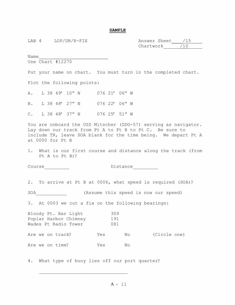
A - 11
SAMPLE LAB 4 LOP/DR/R-FIX Answer Sheet____/15____ Chartwork______/10_____
Name_________________________ Use Chart #12270 Put your name on chart. You must turn in the completed chart. Plot the following points: A. L 38 49’ 10” N 076 21’ 06” W B. L 38 48’ 27” N 076 22’ 06” W C. L 38 48’ 37” N 076 25’ 51” W You are onboard the USS Mitscher (DDG-57) serving as navigator. Lay down our track from Pt A to Pt B to Pt C. Be sure to include TR, leave SOA blank for the time being. We depart Pt A at 0000 for Pt B 1. What is our first course and distance along the track (from
Pt A to Pt B)? Course_________ Distance_________ 2. To arrive at Pt B at 0006, what speed is required (SOA)? SOA___________ (Assume this speed is now our speed) 3. At 0003 we cut a fix on the following bearings: Bloody Pt. Bar Light 309 Poplar Harbor Chimney 191 Wades Pt Radio Tower 081 Are we on track? Yes No (Circle one) Are we on time? Yes No 4. What type of buoy lies off our port quarter?
________________________________
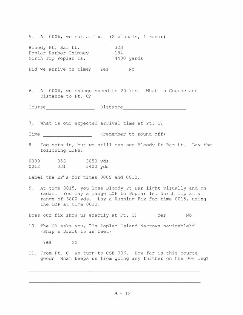
A - 12
5. At 0006, we cut a fix. (2 visuals, 1 radar) Bloody Pt. Bar Lt. 323 Poplar Harbor Chimney 184 North Tip Poplar Is. 4400 yards Did we arrive on time? Yes No 6. At 0006, we change speed to 20 kts. What is Course and
Distance to Pt. C? Course_________________ Distance______________________ 7. What is our expected arrival time at Pt. C? Time _________________ (remember to round off) 8. Fog sets in, but we still can see Bloody Pt Bar Lt. Lay the
following LOPs: 0009 356 3050 yds 0012 031 3400 yds Label the EP’s for times 0009 and 0012. 9. At time 0015, you lose Bloody Pt Bar light visually and on
radar. You lay a range LOP to Poplar Is. North Tip at a range of 6800 yds. Lay a Running Fix for time 0015, using the LOP at time 0012.
Does our fix show us exactly at Pt. C? Yes No 10. The CO asks you, “Is Poplar Island Narrows navigable?”
(Ship’s Draft 15 is feet)
Yes No 11. From Pt. C, we turn to CSE 006. How far is this course
good? What keeps us from going any further on the 006 leg? ____________________________________________________________ ____________________________________________________________
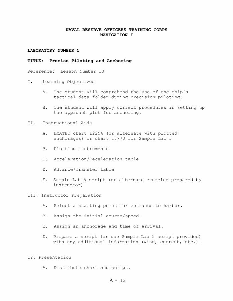
A - 13
NAVAL RESERVE OFFICERS TRAINING CORPS NAVIGATION I
LABORATORY NUMBER 5 TITLE: Precise Piloting and Anchoring Reference: Lesson Number 13 I. Learning Objectives A. The student will comprehend the use of the ship's tactical data folder during precision piloting. B. The student will apply correct procedures in setting up the approach plot for anchoring. II. Instructional Aids A. DMATHC chart 12254 (or alternate with plotted
anchorages) or chart 18773 for Sample Lab 5 B. Plotting instruments C. Acceleration/Deceleration table D. Advance/Transfer table E. Sample Lab 5 script (or alternate exercise prepared by
instructor) III. Instructor Preparation A. Select a starting point for entrance to harbor. B. Assign the initial course/speed. C. Assign an anchorage and time of arrival. D. Prepare a script (or use Sample Lab 5 script provided)
with any additional information (wind, current, etc.). IY. Presentation
A. Distribute chart and script.

A - 14
B. Using the advance/transfer and acceleration/deceleration
tables, students should lay out intended track and turn bearing and the complete anchorage plot to include head bearings, letting-go circle, letting-go bearing, range circles, and drag circle.
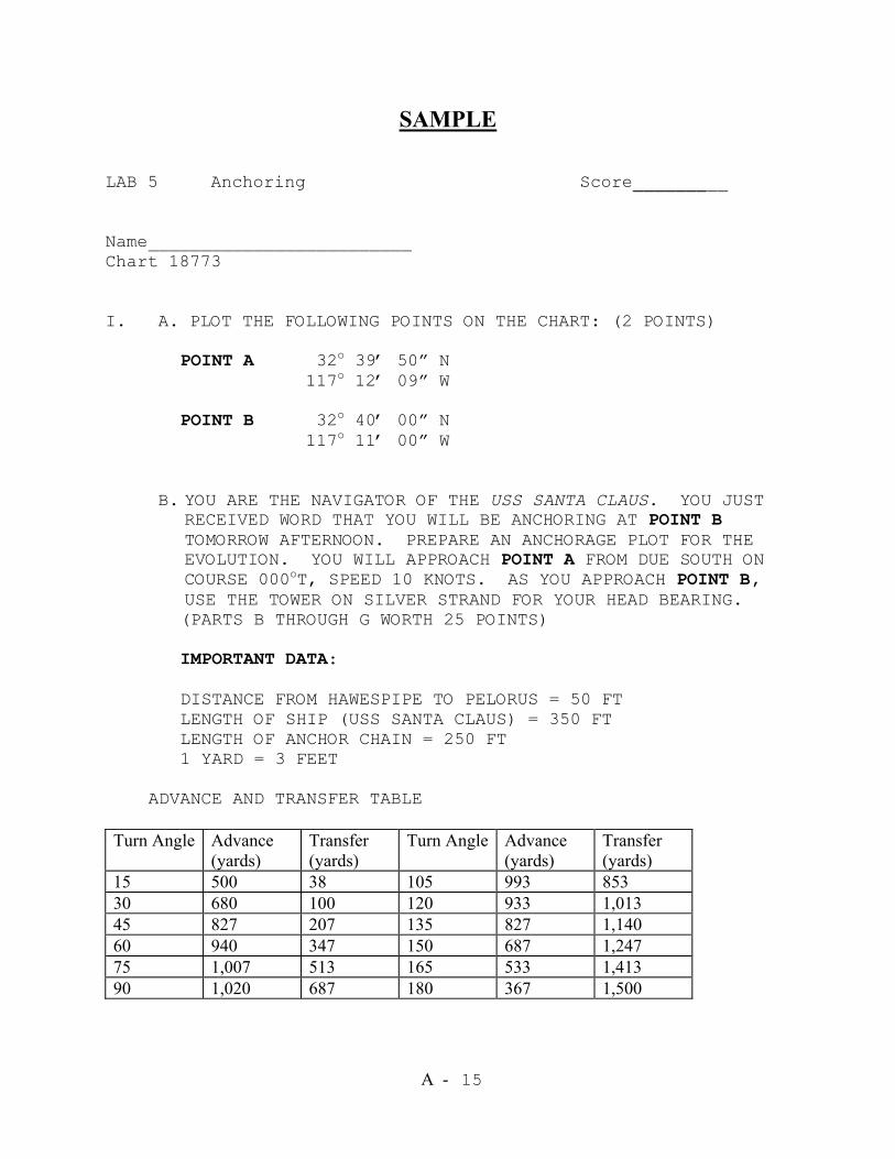
A - 15
SAMPLE LAB 5 Anchoring Score_________
Name_________________________ Chart 18773 I. A. PLOT THE FOLLOWING POINTS ON THE CHART: (2 POINTS)
POINT A 32o 39’ 50” N 117o 12’ 09” W
POINT B 32o 40’ 00” N 117o 11’ 00” W
B. YOU ARE THE NAVIGATOR OF THE USS SANTA CLAUS. YOU JUST
RECEIVED WORD THAT YOU WILL BE ANCHORING AT POINT B TOMORROW AFTERNOON. PREPARE AN ANCHORAGE PLOT FOR THE EVOLUTION. YOU WILL APPROACH POINT A FROM DUE SOUTH ON COURSE 000oT, SPEED 10 KNOTS. AS YOU APPROACH POINT B, USE THE TOWER ON SILVER STRAND FOR YOUR HEAD BEARING. (PARTS B THROUGH G WORTH 25 POINTS) IMPORTANT DATA: DISTANCE FROM HAWESPIPE TO PELORUS = 50 FT LENGTH OF SHIP (USS SANTA CLAUS) = 350 FT LENGTH OF ANCHOR CHAIN = 250 FT 1 YARD = 3 FEET
ADVANCE AND TRANSFER TABLE
Turn Angle Advance
(yards) Transfer (yards)
Turn Angle Advance (yards)
Transfer (yards)
15 500 38 105 993 853 30 680 100 120 933 1,013 45 827 207 135 827 1,140 60 940 347 150 687 1,247 75 1,007 513 165 533 1,413 90 1,020 687 180 367 1,500
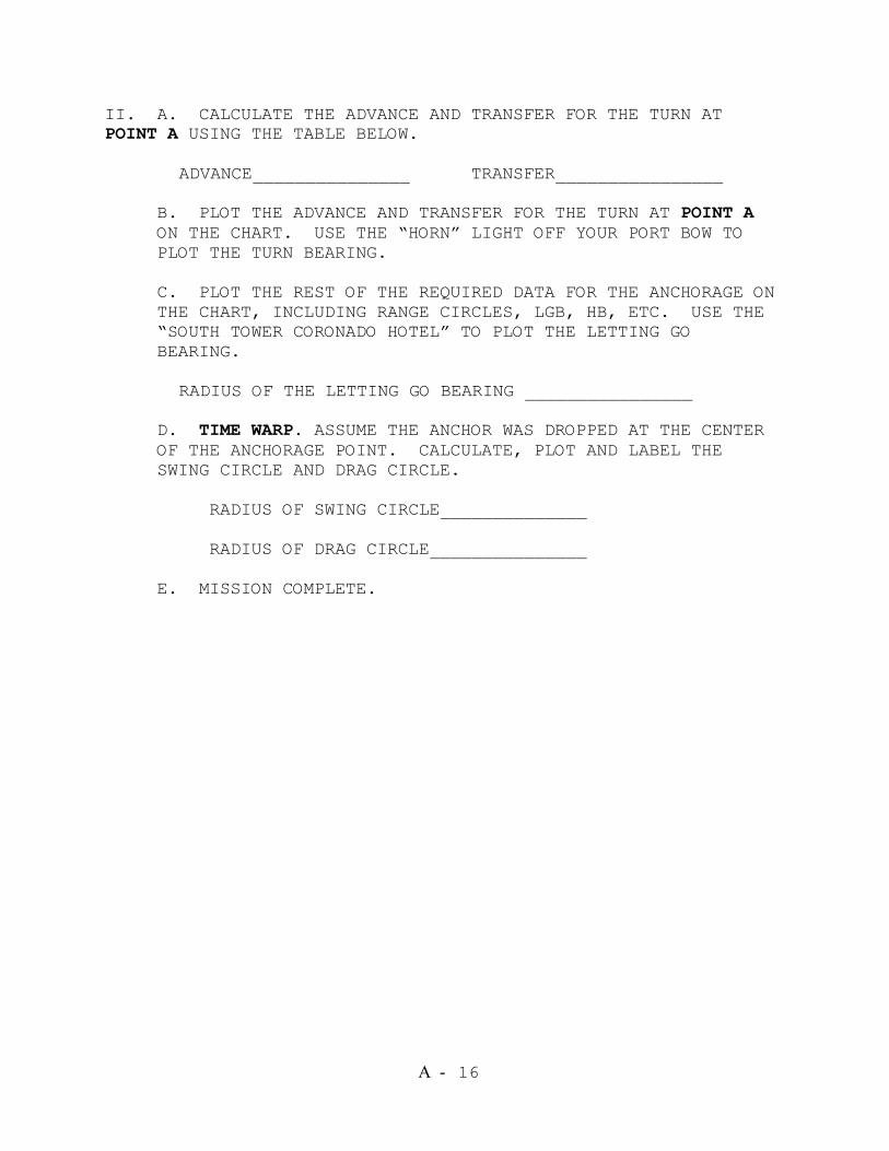
A - 16
II. A. CALCULATE THE ADVANCE AND TRANSFER FOR THE TURN AT POINT A USING THE TABLE BELOW.
ADVANCE_______________ TRANSFER________________
B. PLOT THE ADVANCE AND TRANSFER FOR THE TURN AT POINT A ON THE CHART. USE THE “HORN” LIGHT OFF YOUR PORT BOW TO PLOT THE TURN BEARING.
C. PLOT THE REST OF THE REQUIRED DATA FOR THE ANCHORAGE ON THE CHART, INCLUDING RANGE CIRCLES, LGB, HB, ETC. USE THE “SOUTH TOWER CORONADO HOTEL” TO PLOT THE LETTING GO BEARING.
RADIUS OF THE LETTING GO BEARING ________________
D. TIME WARP. ASSUME THE ANCHOR WAS DROPPED AT THE CENTER OF THE ANCHORAGE POINT. CALCULATE, PLOT AND LABEL THE SWING CIRCLE AND DRAG CIRCLE.
RADIUS OF SWING CIRCLE______________
RADIUS OF DRAG CIRCLE_______________
E. MISSION COMPLETE.
A - 17
NAVAL RESERVE OFFICERS TRAINING CORPS NAVIGATION I
LABORATORY NUMBER 6 TITLE: Practical Plotting Exercise Reference: Lesson Number 14 I. Learning Objective: The student will apply correct procedures for basic plotting techniques used in piloting in a timed exercise. II. References and Texts: None III. Instructional Aids A. Plotting exercise scenario and script (attached) B. DMAHTC 12254 C. Plotting instruments D. Audiocassette player and prerecorded cassette
(Optional) E. The NAVSIM computer software may be programmed by the instructor for this exercise. IV. Instructor Preparation
A. Review plotting exercise.
B. Make copies of exercise (attached).
C. Record script onto an audiocassette in proper time sequence (optional).
V. Presentation
A. Distribute scenarios and charts.
B. Students can work in pairs or independently in accordance with the exercise scenario.
C. Present the scenario.

A - 18
D. Present the script, either by reading or playing recorded cassette.
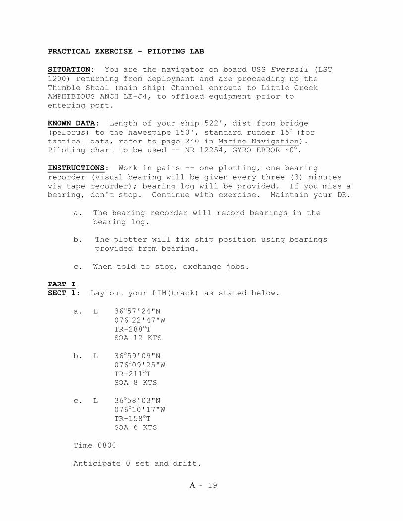
A - 19
PRACTICAL EXERCISE - PILOTING LAB SITUATION: You are the navigator on board USS Eversail (LST 1200) returning from deployment and are proceeding up the Thimble Shoal (main ship) Channel enroute to Little Creek AMPHIBIOUS ANCH LE-J4, to offload equipment prior to entering port. KNOWN DATA: Length of your ship 522', dist from bridge (pelorus) to the hawespipe 150', standard rudder 15o (for tactical data, refer to page 240 in Marine Navigation). Piloting chart to be used -- NR 12254, GYRO ERROR ~0o. INSTRUCTIONS: Work in pairs -- one plotting, one bearing recorder (visual bearing will be given every three (3) minutes via tape recorder); bearing log will be provided. If you miss a bearing, don't stop. Continue with exercise. Maintain your DR. a. The bearing recorder will record bearings in the bearing log. b. The plotter will fix ship position using bearings
provided from bearing. c. When told to stop, exchange jobs. PART I SECT 1: Lay out your PIM(track) as stated below. a. L 36o57'24"N 076o22'47"W TR-288oT SOA 12 KTS b. L 36o59'09"N 076o09'25"W TR-211OT SOA 8 KTS c. L 36o58'03"N 076o10'17"W TR-158oT SOA 6 KTS Time 0800 Anticipate 0 set and drift.
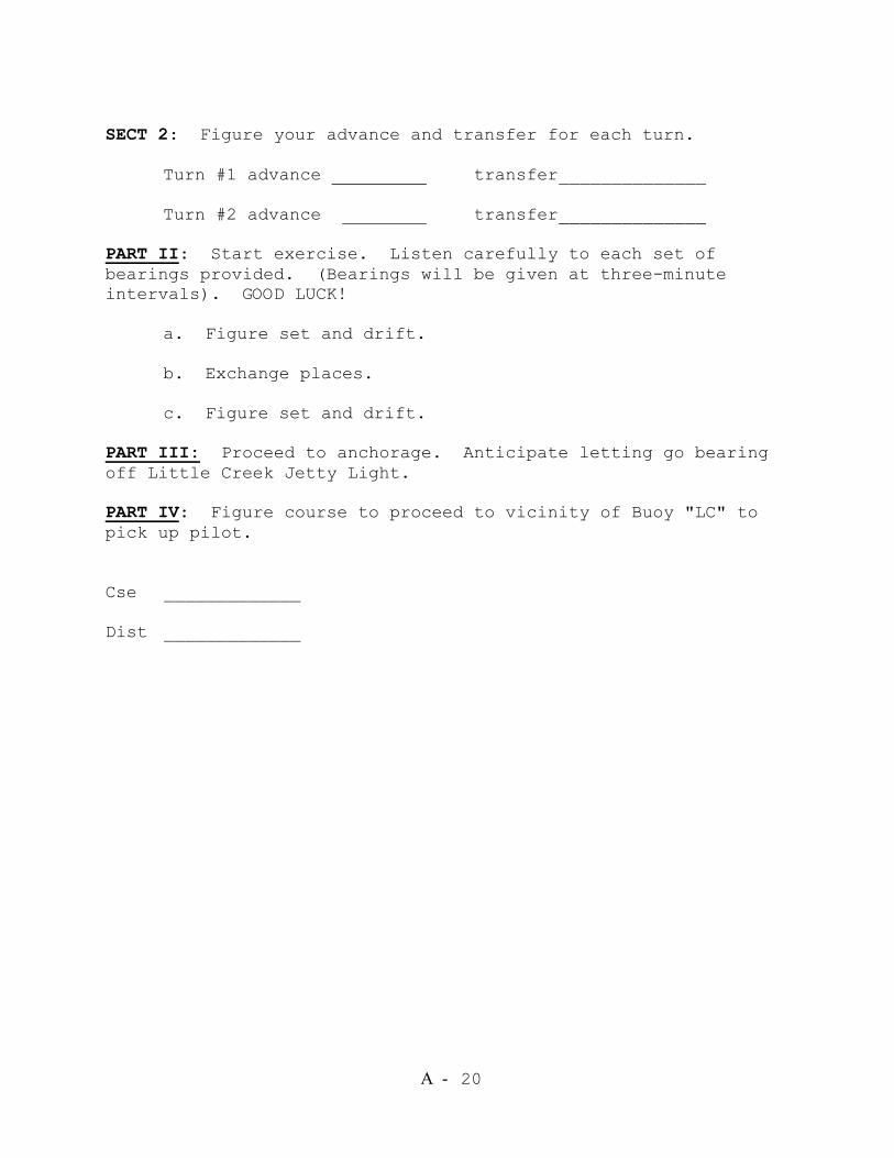
A - 20
SECT 2: Figure your advance and transfer for each turn. Turn #1 advance transfer______________ Turn #2 advance transfer______________ PART II: Start exercise. Listen carefully to each set of bearings provided. (Bearings will be given at three-minute intervals). GOOD LUCK! a. Figure set and drift. b. Exchange places. c. Figure set and drift. PART III: Proceed to anchorage. Anticipate letting go bearing off Little Creek Jetty Light. PART IV: Figure course to proceed to vicinity of Buoy "LC" to pick up pilot. Cse _____________ Dist _____________
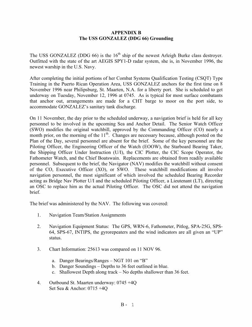
B - 1
APPENDIX B The USS GONZALEZ (DDG 66) Grounding
The USS GONZALEZ (DDG 66) is the 16th ship of the newest Arleigh Burke class destroyer. Outfitted with the state of the art AEGIS SPY1-D radar system, she is, in November 1996, the newest warship in the U.S. Navy. After completing the initial portions of her Combat Systems Qualification Testing (CSQT) Type Training in the Puerto Rican Operation Area, USS GONZALEZ anchors for the first time on 8 November 1996 near Philipsburg, St. Maarten, N.A. for a liberty port. She is scheduled to get underway on Tuesday, November 12, 1996 at 0745. As is typical for most surface combatants that anchor out, arrangements are made for a CHT barge to moor on the port side, to accommodate GONZALEZ’s sanitary tank discharge. On 11 November, the day prior to the scheduled underway, a navigation brief is held for all key personnel to be involved in the upcoming Sea and Anchor Detail. The Senior Watch Officer (SWO) modifies the original watchbill, approved by the Commanding Officer (CO) nearly a month prior, on the morning of the 11th. Changes are necessary because, although posted on the Plan of the Day, several personnel are absent for the brief. Some of the key personnel are the Piloting Officer, the Engineering Officer of the Watch (EOOW), the Starboard Bearing Taker, the Shipping Officer Under Instruction (U/I), the CIC Plotter, the CIC Scope Operator, the Fathometer Watch, and the Chief Boatswain. Replacements are obtained from readily available personnel. Subsequent to the brief, the Navigator (NAV) modifies the watchbill without consent of the CO, Executive Officer (XO), or SWO. These watchbill modifications all involve navigation personnel, the most significant of which involved the scheduled Bearing Recorder acting as Bridge Nav Plotter U/I and the scheduled Piloting Officer, a Lieutenant (LT), directing an OSC to replace him as the actual Piloting Officer. The OSC did not attend the navigation brief. The brief was administered by the NAV. The following was covered:
1. Navigation Team/Station Assignments
2. Navigation Equipment Status: The GPS, WRN-6, Fathometer, Pitlog, SPA-25G, SPS-64, SPS-67, INTIPS, the gyrorepeaters and the wind indicators are all given an “UP” status.
3. Chart Information: 25613 was compared on 11 NOV 96.
a. Danger Bearings/Ranges – NGT 101 on “B” b. Danger Soundings – Depths to 36 feet outlined in blue. c. Shallowest Depth along track – No depths shallower than 36 feet.
4. Outbound St. Maarten underway: 0745 +4Q Set Sea & Anchor: 0715 +4Q
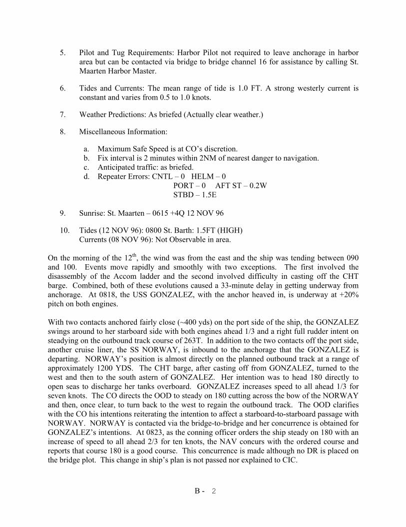
B - 2
5. Pilot and Tug Requirements: Harbor Pilot not required to leave anchorage in harbor area but can be contacted via bridge to bridge channel 16 for assistance by calling St. Maarten Harbor Master.
6. Tides and Currents: The mean range of tide is 1.0 FT. A strong westerly current is constant and varies from 0.5 to 1.0 knots.
7. Weather Predictions: As briefed (Actually clear weather.)
8. Miscellaneous Information:
a. Maximum Safe Speed is at CO’s discretion. b. Fix interval is 2 minutes within 2NM of nearest danger to navigation. c. Anticipated traffic: as briefed. d. Repeater Errors: CNTL – 0 HELM – 0
PORT – 0 AFT ST – 0.2W STBD – 1.5E
9. Sunrise: St. Maarten – 0615 +4Q 12 NOV 96
10. Tides (12 NOV 96): 0800 St. Barth: 1.5FT (HIGH) Currents (08 NOV 96): Not Observable in area.
On the morning of the 12th, the wind was from the east and the ship was tending between 090 and 100. Events move rapidly and smoothly with two exceptions. The first involved the disassembly of the Accom ladder and the second involved difficulty in casting off the CHT barge. Combined, both of these evolutions caused a 33-minute delay in getting underway from anchorage. At 0818, the USS GONZALEZ, with the anchor heaved in, is underway at +20% pitch on both engines. With two contacts anchored fairly close (~400 yds) on the port side of the ship, the GONZALEZ swings around to her starboard side with both engines ahead 1/3 and a right full rudder intent on steadying on the outbound track course of 263T. In addition to the two contacts off the port side, another cruise liner, the SS NORWAY, is inbound to the anchorage that the GONZALEZ is departing. NORWAY’s position is almost directly on the planned outbound track at a range of approximately 1200 YDS. The CHT barge, after casting off from GONZALEZ, turned to the west and then to the south astern of GONZALEZ. Her intention was to head 180 directly to open seas to discharge her tanks overboard. GONZALEZ increases speed to all ahead 1/3 for seven knots. The CO directs the OOD to steady on 180 cutting across the bow of the NORWAY and then, once clear, to turn back to the west to regain the outbound track. The OOD clarifies with the CO his intentions reiterating the intention to affect a starboard-to-starboard passage with NORWAY. NORWAY is contacted via the bridge-to-bridge and her concurrence is obtained for GONZALEZ’s intentions. At 0823, as the conning officer orders the ship steady on 180 with an increase of speed to all ahead 2/3 for ten knots, the NAV concurs with the ordered course and reports that course 180 is a good course. This concurrence is made although no DR is placed on the bridge plot. This change in ship’s plan is not passed nor explained to CIC.
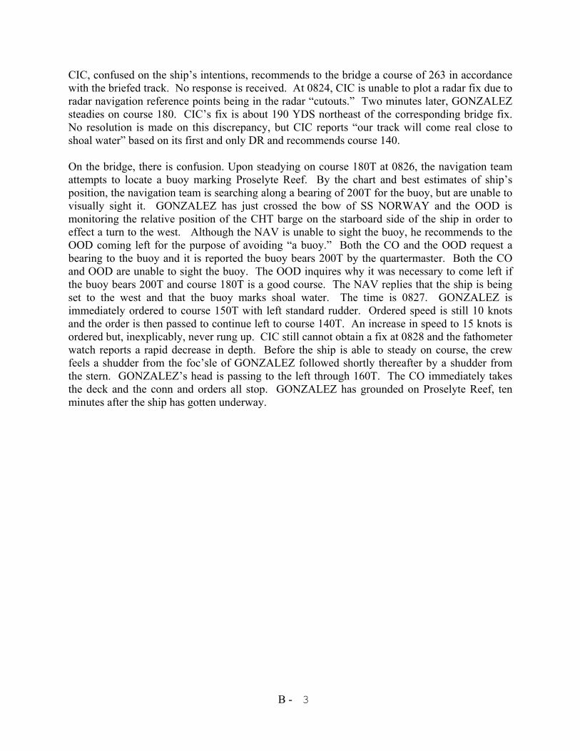
B - 3
CIC, confused on the ship’s intentions, recommends to the bridge a course of 263 in accordance with the briefed track. No response is received. At 0824, CIC is unable to plot a radar fix due to radar navigation reference points being in the radar “cutouts.” Two minutes later, GONZALEZ steadies on course 180. CIC’s fix is about 190 YDS northeast of the corresponding bridge fix. No resolution is made on this discrepancy, but CIC reports “our track will come real close to shoal water” based on its first and only DR and recommends course 140. On the bridge, there is confusion. Upon steadying on course 180T at 0826, the navigation team attempts to locate a buoy marking Proselyte Reef. By the chart and best estimates of ship’s position, the navigation team is searching along a bearing of 200T for the buoy, but are unable to visually sight it. GONZALEZ has just crossed the bow of SS NORWAY and the OOD is monitoring the relative position of the CHT barge on the starboard side of the ship in order to effect a turn to the west. Although the NAV is unable to sight the buoy, he recommends to the OOD coming left for the purpose of avoiding “a buoy.” Both the CO and the OOD request a bearing to the buoy and it is reported the buoy bears 200T by the quartermaster. Both the CO and OOD are unable to sight the buoy. The OOD inquires why it was necessary to come left if the buoy bears 200T and course 180T is a good course. The NAV replies that the ship is being set to the west and that the buoy marks shoal water. The time is 0827. GONZALEZ is immediately ordered to course 150T with left standard rudder. Ordered speed is still 10 knots and the order is then passed to continue left to course 140T. An increase in speed to 15 knots is ordered but, inexplicably, never rung up. CIC still cannot obtain a fix at 0828 and the fathometer watch reports a rapid decrease in depth. Before the ship is able to steady on course, the crew feels a shudder from the foc’sle of GONZALEZ followed shortly thereafter by a shudder from the stern. GONZALEZ’s head is passing to the left through 160T. The CO immediately takes the deck and the conn and orders all stop. GONZALEZ has grounded on Proselyte Reef, ten minutes after the ship has gotten underway.
B - 4
The BOLINAO Affair A Case Study of USS Dubuque (LPD-8)
INTRODUCTION
The following scenario explains, in general, the facts and circumstances surrounding the encounter in the South China Sea between the USS Dubuque (LPD-8) and a small wooden boat, the Bolinao, filled with Vietnamese refugees. Over a period of two hours, decisions would be made by a highly decorated Navy captain with an unblemished career that would result in death by starvation and murder of Vietnamese refugees. The facts related are incomplete, though substantially accurate; many of the details have been modified to clarify the ethical principles involved. The circumstances below, related in narrative form, are drawn from four perspectives: First, the commanding officer of the Dubuque. His story is based on details reported in the news media as depicting the facts that became known to him on the bridge of his ship. Second is the perspective of a Dubuque crewman of Vietnamese origin named Pham who was the direct source of communication with the Vietnamese refugees. The third point of view is that of a fictitious refugee named Duong whose story is a composite of information derived from several interviews of refugees after their arrival at a refugee camp in the Philippines. The final view is that of the Dubuque’s executive officer. A conscientious effort has been made to relate the circumstances known to each of these individuals during the two-hour period that the Dubuque rendered assistance to the passengers of the refugee boat, but it should not be inferred that the complete understanding of each individual is accurately portrayed. The monologues attributed to each of our characters are not direct quotes, but rather composites of statements reported either in the news media or documented in the Navy JAG Manual investigation. The perspective of the commanding officer -- what he knew and when he knew it -- is revealed in the course of this narrative, but you should avoid confusing information and facts not available to him when assessing the ethical and moral responsibility and accountability. Twenty-twenty hindsight establishes that the C.O. did not have completely accurate information with which to correctly determine the appropriate level of assistance that Navy Regulations and standard operating orders required him to render. You should also consider the conduct of the Dubuque’s executive officer and of the other individuals involved. Consider as well the responsibilities, if any, of personnel not mentioned in these narratives. At the conclusion of the statement of facts regarding this incident, specific issues will be identified to assist you in your analysis. PERSPECTIVES The Predicate Facts The USS Dubuque (LPD-8) had been ordered to arrive on station at Bahrain on time to assume a mission as flagship for minesweepers in the Persian Gulf. Dubuque’s commanding officer, Captain Alexander G. Balian, was to be the Officer in Tactical Command (OTC). In company was the USS Kirk (FF-1087); the USNS Kilauea (TAE-26) was nearby, bound for Subic Bay.
B - 5
USS Dubuque is a 21-year old, Austin-class LPD rated at 20 knots and home ported in Sasebo, Japan. She has a crew of 396 enlisted and 20 officers and can embark 900 Marines. During this voyage Dubuque was carrying a Marine MAG including a Force Recon unit with Zodiac boats. On June 9, 1988, while transiting the South China Sea on the way to the Persian Gulf, the Dubuque closed on a small wooden boat of the Chinese “junk” variety equipped with a small makeshift sail, but otherwise without a visible means of propulsion. Original estimates put the number of persons on board the junk at about 50 or 60 Vietnamese refugees (later determined to number 83). When sighted, the refugees were frantically waving their arms and signaling with a white flag for assistance. The Dubuque’s C.O., Captain Balian, together with the executive officer and operations officer, began to review standard operating orders regarding requirements to render assistance to refugees found at sea. He located two relevant orders: first, CINCPACFLT OPORDER 201, Tab G to Appendix G to annex C (C) and, second, COMTHIRDFLT/COMSEVENTHFLT OPORDER 201, Tab D to Appendix 6 to Annex C (C). Both of these were interpreted by the C.O. to require a determination of the seaworthiness of the refugee boat. On this determination would hinge the decision of whether it was necessary to bring the refugees aboard the Dubuque. Captain Balian was a twenty-five year Navy veteran with two previous at-sea commands. He was the recipient of a Silver Star and a Purple Heart awarded during the Vietnam War. On two previous occasions, Captain Balian had been involved with the rescue of Vietnamese refugees. This situation seemed different to him. The chaos, desperation, and confusion exhibited by refugees on the deck of this junk was something Captain Balian had never before witnessed, and this circumstance gave him some concern for the safety of his crew. After the Dubuque closed within 500 yards of the junk, a few refugees in desperation swam for the ship, but the commanding officer (CO) would not allow them to board. At least one swimmer drowned in the attempt, being too far from the ship to be saved. A few life preservers were thrown by crewmen to the swimmers, but the CO ordered that no further preservers be thrown to avoid giving the refugees false hope. Other swimmers attempted to climb lines attached to the ship but were directed by the CO, through a Vietnamese speaking crewman, not to attempt to and to return to their boat. Some crewmen reported seeing other crewmen shake refugees off the lines and into the sea as a result of the Captain’s order not to allow the refugees on board. The CO denies that this occurred. To comply with the relevant OPORDERS, the CO ordered his executive officer (XO) to launch the motor whaleboat with an investigating party to inspect the refugee boat from a close distance and to interrogate the refugees with the assistance of the Vietnamese-speaking crewman. The XO was ordered by the CO not to board the refugee boat -- the customary procedure. The motor whaleboat circled the refugee’s boat from ten yards. Observations of the investigating party led to the conclusion that the craft did not appear to be taking on water and the investigating team detected no external evidence of a motor. The CO concluded from this report that the vessel’s only means of propulsion appeared to be a small make-shift sail. Although the passengers,
B - 6
consisting of men, women and children, appeared emaciated and filled with anxiety, the XO determined and recommended to the CO that no medical assistance was needed and that the junk was seaworthy. THE CAPTAIN’S PERSPECTIVE I’m being blamed for it... and even worse than that, is how the Navy hangs you out to dry when you get in trouble. Al Balian... who’s that? I feel bad that people were lost...but 50 ships saw the refugee boat and passed them by...twenty-three lost their lives trying to swim to them. On the morning of the 17th day, hope appeared in the form of the USS Dubuque. The Navy instructs us to pick up people if their boat isn’t seaworthy and I had rescued refugees twice before, but this boat looked different, dangerous for men to go on board. There was a lot of frantic movement on the junk. I never saw that before. And, they were jumping in the water. I made my first key decision: send the XO out but not to board. And I used Pham, the first mistake in a tragedy of errors.” (THE VIETNAMESE INTERPRETER ABOARD THE WHALEBOAT
INCORRECTLY REPORTED THAT THE REFUGEES HAD LEFT VIETNAM FOR THE PHILIPPINES SEVEN DAYS EARLIER, RATHER THAN SEVENTEEN, AND THAT THE BOAT HAD NO ENGINE, RATHER THAN A BROKEN ENGINE THAT HAD FAILED AFTER THREE DAYS AT SEA. HE FAILED TO REPORT THAT ONE OF THE DEAD BODIES OBSERVED IN THE WATER HAD DIED FROM STARVATION AND NOT DROWNING AND THAT TWENTY REFUGEES HAD DIED SINCE THE VOYAGE BEGAN. HE INFORMED THE REFUGEES THAT THEY WOULD BE PROVIDED FOOD AND WATER, BUT WOULD NOT BE EMBARKED IN THE SHIP. DISTRESSED THAT THEY WOULD NOT BE RESCUED, HE MISREPRESENTED THAT ANOTHER SHIP WOULD PICK THEM UP IN TWO DAYS.)
(PURSUANT TO THE OPORDER, THE DUBUQUE SENT MESSAGES TO
CINCPACFLT ADVISING THAT: 50-60 PERSONS INCLUDING CHILDREN WERE ABOARD THE BOAT AND WERE REQUESTING PROVISIONS; A DETERMINATION WAS MADE THAT MEDICAL ATTENTION WAS NOT REQUIRED; ONE FLOATING BODY WAS OBSERVED IN THE VICINITY OF THE BOAT; DETAILED INSPECTION REVEALED THE BOAT WAS UNDAMAGED AND SEAWORTHY; AND ALL POSSIBLE HUMANITARIAN ASSIST EFFORTS HAD BEEN COMPLETED. CONTRARY TO THE OPORDERS, THE DUBUQUE FAILED TO REPORT THE NUMBER OF DAYS THE REFUGEES HAD BEEN AT SEA AND THE NUMBER OF REFUGEES LOST SINCE THE VOYAGE BEGAN.)
THE CAPTAIN CONTINUES: What I want to do is not always what I can do. I don’t work that way. As a naval officer I have to follow instructions and my guidance. Remember, this was the summer of 1988, operations in the Persian Gulf were coming to a head and there were various incidents with Iraqi and Iranian
B - 7
forces occurring. As prospective OTC, it was imperative that we make our scheduled PIM and arrive on station in a timely manner. Dubuque was carrying the MAG TAF and Recon Marines. We had no accommodations for foreign civilians. I also knew that if I embarked the boat people, the voyage back to Subic would cost at least 3 days, and Kilauea could not take them on board because she was an ammunition ship. As a former CO of Kilauea, I knew that was no place to embark chaotic foreign civilians.” (THE USNS KILAUEA WAS STEAMING IN THE VICINITY OF THE DUBUQUE
AND OFFERED TO RENDER ASSISTANCE. ITS OFFER WAS REJECTED, AND IT PROCEEDED TO SUBIC BAY NAVAL STATION BUT COULD HAVE TAKEN THE REFUGEES DIRECTLY ASHORE. AFTER RENDERING ASSISTANCE, THE DUBUQUE DEPARTED THE REFUGEE BOAT AND PROCEEDED TOWARD THE PERSIAN GULF IN FURTHERANCE OF ITS MISSION.)
The XO reported that no medical assistance was needed, that the vessel was seaworthy and that they had been at sea 7 days. Based on that fact, I concluded that they could sail the other 200 plus miles to the Philippines in about the same time. I gave them 300 pounds of fresh fruit, 107 pounds of canned food, 60 pounds of rice (uncooked), 50 gallons of fresh water, plus navigational charts that showed them the way to the Philippines. They say if it wasn’t for us, they would all be dead.” (SINCE THE REFUGEE BOAT HAD COMPLETED ABOUT 250 MILES OF ITS
VOYAGE FROM VIETNAM TO THE PHILIPPINES IN SEVEN DAYS, THE CO CALCULATED THE REFUGEES WERE HALFWAY TO THEIR DESTINATION; AND, THEREFORE, ORDERED THEIR BOAT STOCKED WITH SUFFICIENT FOOD AND WATER FOR AN ADDITIONAL SEVEN DAYS, AND ORDERED THAT THEY BE INSTRUCTED TO FOLLOW THE SUN” FOR NAVIGATION. WATER AND SOUP WERE PROVIDED IN PLASTIC BAGS, SOME OF WHICH BROKE ENROUTE AND THE REFUGEES SPILLED SOME IN THEIR HASTE TO DRINK AND EAT. IT IS UNKNOWN WHETHER THESE FACTS WERE MADE KNOWN TO THE CO. IN ADDITION TO FOOD AND WATER, THE DUBUQUE PROVIDED THE REFUGEES WITH A CHART AND WRITTEN INSTRUCTIONS TO FOLLOW THE RISING SUN.” A COMPASS WAS NOT PROVIDED. NONE OF THE INSPECTION TEAM, INCLUDING THE TRANSLATOR, WAS DEBRIEFED.)
Look, the Navy is setting me up as a scapegoat. I tried to follow a regulation that was inadequate. Look, the previous Captain of Dubuque was appointed to head the investigation. He had been a target of criticism when I took over Dubuque. Some of the things I discovered might have been embarrassing to him and my seniors. I’d reported those conditions. Its unusual to put the previous skipper in the position of conducting the investigation. What would you think of that? I turned down Admirals Mast. I wanted a court-martial to clear my name. I care about what I do. The refugees are on my side. They sent a letter to our ambassador to the Philippines. They recognized in the letter the humanity of our efforts, of the aid we rendered. They said, ‘It is unbearable to have one American suffer for their actions.’”
B - 8
(THE REFUGEE BOAT DRIFTED WITH THE CURRENT FOR 19 MORE DAYS BEFORE ITS PASSENGERS WERE RESCUED BY PHILIPPINE FISHERMEN FROM THE PHILIPPINE ISLAND OF PALAWAN, OVER 390 NM AWAY. IN THE INTERIM, 30 MORE REFUGEES DIED; MOST BY STARVATION AND DROWNING, BUT FOUR WERE MURDERED FOR FOOD. ALL 55 SURVIVORS PARTICIPATED IN CANNIBALISM IN ORDER TO SURVIVE.)
THE PERSPECTIVE OF THE ICFN PHAM (FREQUENTLY, PERSONS OBSERVING THE SAME FACTS AND LISTENING TO THE SAME DISCUSSIONS ARRIVE AT RADICALLY DIFFERENT CONCLUSIONS ABOUT WHAT THEY SAW AND HEARD. SOME OF THE “FACTS” WITNESSED BY ICFN PHAM, WHO SERVED AS AN INTERPRETER FOR THE REFUGEES, HAVE A FAR DIFFERENT “SPIN” ON THEM FROM THOSE WITNESSED BY THE CO AND XO. AT A CRITICAL JUNCTURE IN THE STORY, THESE DIFFERING PERCEPTIONS CAUSED HIM TO ARRIVE AT FAR DIFFERENT CONCLUSIONS.) PHAM’S PERSPECTIVE: “At 0900 on 9 June 1988, I was paged and instructed to report to the bridge. As I made my way to the bridge, I noticed a boat full of Vietnamese about 300 yards from USS Dubuque. I saw three Vietnamese swimming toward us. The CO instructed me to tell the swimmers to stay away so they would not be sucked in by the ship’s propellers. I heard the CO yell at some of the other sailors because they had thrown life preservers into the water for the swimmers. One young woman became visibly tired, floundered, screamed for help and then disappeared beneath the waves. The woman had drowned in less then seven minutes from first showing signs of distress. I realized that if the whaleboat had been launched immediately upon hearing the woman’s cry for help, it would have been unlikely that she could have been saved. She was too far away. (THE REMAINDER OF THE SWIMMERS REACHED THE SHIP AND BEGAN TO CLIMB THE LINES ATTACHED TO HER SIDE. IN RESPONSE TO THE CO’S ORDER NOT TO LET THE REFUGEES ABOARD THE SHIP, OTHER CREW MEMBERS SHOOK THE LINES CAUSING THE REFUGEES TO FALL BACK INTO THE SEA. SOME OF THE LIFE PRESERVERS WERE THROWN INTO THE SEA. EVIDENCE CONFLICTS ON WHAT HAPPENED NEXT, BUT APPARENTLY THE CAPTAIN ASKED WHO HAD ORDERED THAT. THE QUESTION BROUGHT THAT RESCUE ATTEMPT TO A HALT, BUT THERE IS NO EVIDENCE THAT THAT WAS THE CAPTAIN’S INTENT.) “An investigating party led by the XO then launched the whaleboat to inspect the junk from a close distance to determine what kind of assistance must be rendered. I joined the team as an interpreter, knowing that the XO had been ordered not to board the junk. The whaleboat with her inspection team circled the junk slowly observing her seaworthiness and the condition of her passengers. As to the former, the vessel seemed dead in the water, but she was not taking on water. The small, improvised sail, about 5’ by 6’, appeared to be fashioned from bed sheets and insufficient either to propel the junk or steer her. It was clear to me that the small craft was
B - 9
not seaworthy. Someone in the boat told me that water was coming in. I told this to the XO, and I heard him relay that information to the CO on the bridge. As to the latter, the passengers were close to the state of hysteria, crying and gesturing as if in prayer for the Americans to take them aboard the Dubuque. They told us there were more than 100 on board and that more than 20 had died. I saw lots of children. One woman held up her small child begging the inspection team to, at least, save her baby. All of the passengers were starving and complaining that they had been out of food and water for seven days. Other passengers laid motionless on the deck, appearing too weak to sit or stand. Although the Dubuque had corpsmen aboard, none was selected for inspection and no one consulted any of them about their opinions regarding the medical condition of the refugees. (UNFORTUNATELY PHAM EITHER GARBLED OR MISUNDERSTOOD MUCH
OF THE CRUCIAL INFORMATION HE LEARNED FROM INTERROGATING THE REFUGEES AS DISCUSSED EARLIER, BUT HE WAS NOT A TRAINED INTERPRETER AND HE WAS NOT DEBRIEFED AFTER THE INSPECTION-- NOR WERE ANY OF THE INSPECTION TEAM. PHAM MADE ONE INTENTIONAL MISSTATEMENT TO EASE THE GRIEF AND DESPAIR OF THE REFUGEES AFTER LEARNING THAT THE DUBUQUE WOULD GIVE THEM FOOD AND WATER BUT NOT RESCUE THEM. PHAM INCORRECTLY TOLD THE REFUGEES THAT ANOTHER SHIP WOULD PICK THEM UP IN TWO DAYS. THE XO WAS UNAWARE OF THIS MISSTATEMENT UNTIL WEEKS LATER. TO THE CONTRARY, THE XO TOLD PHAM TO INFORM THE REFUGEES THAT THEY WOULD NOT BE RESCUED.)
PHAM CONTINUES: “The refugees said that their boat was sinking, and the XO told me to warn the refugees not to destroy their boat. I was not instructed to ask and did not ask if the refugees needed medical attention, but I did ask if anyone was injured or sick. They said no. Although I was informed by the refugees that 20 had died since the beginning of their voyage, I do not remember passing this information on to the XO. I did tell the XO that they had left Vietnam 17 days before and that they were starving. I wish I had thought to tell them to destroy their boat - no one would have known. A Marine captain aboard the whaleboat stated aloud that ‘these people will die.’ I was angry they were left.” (IN HINDSIGHT, MORE WOULD HAVE LIVED IF TAKEN ABOARD. STILL, IT
IS CLEAR THAT THE VIETNAMESE INTERPRETER’S FINAL ERROR, REASSURING THEM ANOTHER BOAT WOULD PICK THEM UP, LED THE REFUGEES TO MAKE A FATEFUL DECISION. NO ONE THOUGHT TO ASK THE BOAT PEOPLE WHETHER ANYONE ON BOARD COULD READ NAUTICAL CHARTS OR USE A COMPASS.)
THE PERSPECTIVE OF DUONG (DUONG IS A PSEUDONYM REPRESENTING A COMPOSITE OF REFUGEES AND IS USED TO CONVEY THE EVENTS THAT NEXT TRANSPIRED ABOARD THE REFUGEE
B - 10
BOAT. LIKE ALL OTHER STATEMENTS IN THIS CASE STUDY THE “QUOTES” ARE ACTUALLY A SYNOPSIS OF NEWS MEDIA REPORTS AND INTERVIEWS.) DUONG’S PERSPECTIVE: We thought we should stay right there. We ate all the food and drank all the water; many fought and spilled it over the side. In a few days, food was gone and terror began again. My brother fell overboard and was carried away by the waves. We called each other’s names, but no one could save him. On the 31st day, the soldiers who controlled the boat, led by Minh, came looking for someone near death to kill for food. Kuong knew they wanted him. He came to talk to me. He knew what would happen to him. ‘What will happen if tomorrow they come to look for me and I am still alive?’ he asked. But I couldn’t do anything to save him. Kuong was taken to the back of the boat and drowned. His flesh was distributed to the people aboard the boat. They used knives to cut up the flesh then boil it in seawater. All of us were starving. If we didn’t eat the human flesh, we would die. All 52 people ate the meat. Two others died for food. I was to be next, except rescue came the next day.” THE PERSPECTIVE OF THE EXECUTIVE OFFICER (AS WITH ALL PREVIOUS FIRST PERSON NARRATIVES, THE FOLLOWING STATEMENTS ATTRIBUTED TO THE EXECUTIVE OFFICER OF THE USS DUBUQUE ARE FICTITIOUS, THE CONTENT DERIVED FROM PRESS REPORTS AND NAVY DOCUMENTS ATTRIBUTING THE FOLLOWING TO BE HIS PERCEPTION OF EVENTS.) THE XO’S PERSPECTIVE: Everything possible was done to assess the situation of the refugees. No, we didn’t board the refugees’ boat. I checked the instructions and advised the CO that if the craft was seaworthy, we were not obliged to board the refugees. Besides, the Captain had experience in these matters. He had rescued boat people on two previous occasions. He was concerned for the safety of his crew. This group of refugees was acting unruly. Together with Pham and five other crew members, I took the motor whaleboat to determine whether they needed help. We circled the boat, examining it from all sides. The vessel did not appear to me to be taking on water -- the waterline did not change. There was a 5-degree list to port on the stern, probably due to a concentration of refugees in that area, but the stern appeared seaworthy to me. I relayed all information to the Captain by radio. I told Pham repeatedly to ask whether the junk had an engine. He complied, responding each time that the refugees said that the junk had no engine. That made the Captain think that the junk had sailed from Vietnam using the sail. Pham also said there were no injured or ailing on board and that the refugees had been at sea for seven days -- not that they had been without food and water for seven days. I asked each man on the motor whaleboat to estimate the number on board the junk. Our consensus was 50 to 60.” Look, the Skipper went by the book. We had a job to do and we did it. There was a lot of grumbling on board by the sailors about picking up the refugees after we continued on our way.
B - 11
But, we had a mission to perform in the Persian Gulf, and we had to comply with the “Regs.” If Pham had not garbled the information he translated, or if the book required Captain Balian to pick up the refugees, he’d have done it. In my professional judgment, the Captain was afforded the option by the OPORDER and NAVY REGS whether or not to embark the refugees. I can’t let my personal emotions interfere with my professional judgment, and neither can the Captain. (THE XO MADE NO RECOMMENDATION REGARDING THE EMBARKING OF THE REFUGEES. HE WAS NOT ASKED FOR A RECOMMENDATION ON THAT ISSUE, BUT WAS ASKED ABOUT THE VESSEL’S SEAWORTHINESS. THE SPECIFIC ADVICE HE GAVE THE CAPTAIN WAS THAT THEY WERE NOT REQUIRED TO EMBARK THE REFUGEES FROM THE “JUNK” IF THE MISSION WOULD BE JEOPARDIZED, AS LONG AS REASONABLE ASSISTANCE WAS RENDERED UNDER ALL THE CIRCUMSTANCES. IT IS NOT CLEAR WHO DECIDED ON THE CREW OF THE MOTOR WHALEBOAT. THAT CREW INCLUDED A SIGNALMAN, COXSWAIN, GUNNERS MATE, BOWHOOK, AND PHAM -- NO CORPSMAN.)