Embed Size (px)
Citation preview

NPS-OC-14-001CR
NAVAL POSTGRADUATE
SCHOOL
MONTEREY, CALIFORNIA
Approved for public release; distribution is unlimited.
Prepared for: Chief of Naval Operations Energy and Environmental Readiness Division, Washington, D.C.
MOVEMENTS AND SPATIAL USE OF ODONTOCETES IN
THE WESTERN MAIN HAWAIIAN ISLANDS: RESULTS OF A THREE-YEAR STUDY OFF O‘AHU AND KAUA‘I
by
Robin W. Baird, Daniel L. Webster, Sabre D. Mahaffy, Gregory S. Schorr, Jessica M. Aschettino, and Antoinette M. Gorgone
November 2013

THIS PAGE INTENTIONALLY LEFT BLANK

NAVAL POSTGRADUATE SCHOOL Monterey, California 93943-5000
Ronald A. Route Douglas Hensler President Provost The report entitled “Movements and Spatial Use of Odontocetes in the Western Main Hawaiian Islands: Results of a Three-Year Study off Oʻahu and Kauaʻi” was prepared for and funded by Chief of Naval Operations (N45), Washington DC. The report was prepared by Cascadia Research Collective and supported under NPS Grant N00244-10-1-0048. Further distribution of all or part of this report is authorized. This report was prepared by: Robin W. Baird Daniel L. Webster Research Biologist Research Associate Sabre D. Mahaffy Gregory S. Schorr Biologist Biologist Jessica M. Aschettino Antoinette M. Gorgone Research Associate Research Associate Reviewed by: Released by: Peter C. Chu Jeffrey D. Paduan Chairman Dean of Research Department of Oceanography

THIS PAGE INTENTIONALLY LEFT BLANK

REPORT DOCUMENTATION PAGE Form Approved
OMB No. 0704-0188 Public reporting burden for this collection of information is estimated to average 1 hour per response, including the time for reviewing instructions, searching existing data sources, gathering and maintaining the data needed, and completing and reviewing this collection of information. Send comments regarding this burden estimate or any other aspect of this collection of information, including suggestions for reducing this burden to Department of Defense, Washington Headquarters Services, Directorate for Information Operations and Reports (0704-0188), 1215 Jefferson Davis Highway, Suite 1204, Arlington, VA 22202-4302. Respondents should be aware that notwithstanding any other provision of law, no person shall be subject to any penalty for failing to comply with a collection of information if it does not display a currently valid OMB control number. PLEASE DO NOT RETURN YOUR FORM TO THE ABOVE ADDRESS.
1. REPORT DATE (DD-MM-YYYY) 03‐04‐2014
2. REPORT TYPE Technical Report
3. DATES COVERED (From - To) Oct. 2010‐Aug. 2012
4. TITLE AND SUBTITLE 5a. CONTRACT NUMBER
Movements and Spatial Use of Odontocetes in the western Main Hawaiian Islands: Results of a Three‐year Study off O‘ahu and Kaua‘i
5b. GRANT NUMBER N00244‐10‐1‐0048
5c. PROGRAM ELEMENT NUMBER
6. AUTHOR(S) 5d. PROJECT NUMBER
Robin W. Baird, Daniel L. Webster, Sabre D. Mahaffy, Gregory S. Schorr, Jessica M. Aschettino, and Antoinette M. Gorgone
5e. TASK NUMBER
5f. WORK UNIT NUMBER
7. PERFORMING ORGANIZATION NAME(S) AND ADDRESS(ES) Cascadia Research Collective Olympia, Washington 98501
8. PERFORMING ORGANIZATION REPORT NUMBER
9. SPONSORING / MONITORING AGENCY NAME(S) AND ADDRESS(ES) 10. SPONSOR/MONITOR’S ACRONYM(S)Sponsoring Agency: CNO(N45), Washington, D.C. Sponsoring Agency: CNO (N45)
Monitoring Agency: Department of Oceanography, Naval Postgraduate School,
Monitoring Agency: NPS
833 Dyer Road, 11. SPONSOR/MONITOR’S REPORT
Monterey, CA 93943‐5122 NUMBER(S) NPS‐OC‐14‐001CR
12. DISTRIBUTION / AVAILABILITY STATEMENT Approved for public release; distribution is unlimited.
13. SUPPLEMENTARY NOTES The views expressed in this report are those of the authors and do not reflect the official policy or position of the Department of Defense or the US Government.
14. ABSTRACT Understanding the impacts of anthropogenic activities on animal populations requires knowledge of their population structure, sizes, and ranges. In Hawaiian waters this type of basic information has been lacking or is restricted to areas where conditions have been more favorable to research efforts, namely the eastern main Hawaiian Islands. As part of an effort to reduce uncertainty regarding the population structure, range, and abundance of odontocetes in the western main Hawaiian Islands, and to help inform Navy impact assessments, we undertook small‐boat based research efforts off O‘ahu (2010) and Kaua‘i (2011 & 2012). A variety of field methods were used, including photo‐identification, collection of biopsy samples for genetic studies, and satellite tagging. There were 191 odontocete sightings, 183 identified to species. 102 biopsy samples were collected from 7 species. 30 satellite tags were deployed on 5 species: pygmy and false killer whales, bottlenose and rough‐toothed dolphins, and short‐finned pilot whales. Our efforts substantially increased what is known in particular about the movements and habitat use of these 5 species of odontocetes in the western main Hawaiian Islands.
15. SUBJECT TERMS Marine mammals, western Hawaiian Islands, odontocetes, population structure, population size, population range, photo identification, biopsy sampling, satellite tagging, pygmy killer whale, false killer whale, bottlenose dolphin, rough‐toothed dolphin, short‐finned pilot whale.
16. SECURITY CLASSIFICATION OF: Unclassified
17. LIMITATION OF ABSTRACT
18. NUMBER OF PAGES
19a. NAME OF RESPONSIBLE PERSON Tarry Rago
a. REPORT Unclassified
b. ABSTRACT Unclassified
c. THIS PAGEUnclassified
UU 54
19b. TELEPHONE NUMBER (include
area code) 831‐656‐3349
Standard Form 298 (Rev. 8-98)Prescribed by ANSI Std. Z39.18

THIS PAGE INTENTIONALLY LEFT BLANK

i
Contents LIST OF FIGURES LIST OF TABLES TITLE PAGE SUMMARY INTRODUCTION METHODS
Tag types and programming Survey locations, timing, and field methods Photographic and data analyses
RESULTS AND DISCUSSION
Overall survey effort Pygmy killer whales False killer whales Bottlenose dolphins Rough-toothed dolphins Short-finned pilot whales General conclusions
ACKNOWLEDGMENTS LITERATURE CITED
INITIAL DISTRIBUTION LIST
ii
iv
1
2
2
33 4 4
55 6 7 8 9
10 11
11
12
33
ii
List of Figures Figure 1: Figure 2:
Figure 3: Figure 4: Figure 5: Figure 6: Figure 7: Figure 8: Figure 9: Figure 10: Figure 11:
Map showing all survey effort. Locations of two satellite tagged pygmy killer whales (FaTag005 and FaTag006) tagged off O‘ahu in October 2010 and tracked over a 30-day period. Locations of a satellite tagged pygmy killer whale tagged off O‘ahu 24 October 2010 (FaTag007) and tracked over a 7.2-day period. Locations from three satellite tagged false killer whales from the main Hawaiian Islands insular population tagged off O‘ahu in October 2010 and tracked over periods of 13.2 to 51.3 days. Locations of three tagged false killer whales from the Northwestern Hawaiian Islands population tagged off Kaua‘i in June 2012 over periods from 16.6 to 42.1 days. Overlap of satellite-derived locations from individuals from the main Hawaiian Islands insular stock and the individuals tagged in June 2012. Twenty-four hours of dive data from a satellite tagged false killer whale (PcTag026) tagged off O‘ahu in October 2010. The main cluster of the social network of bottlenose dolphins off Kaua‘i and Ni‘ihau, with the tagged individuals indicated. Location data from three satellite tagged bottlenose dolphins tagged off Kaua‘i in 2011 and 2012, with data available for periods ranging from 15 to 32 days. Social network of rough-toothed dolphins photo-identified off Kaua‘i and Ni‘ihau from 2003 through 2012, with tagged individuals indicated. Location data from seven satellite tagged rough-toothed dolphins tagged off Kaua‘i in 2011 and 2012, with data available for periods from 5.9 to 27.5 days.
15
16
17
18
19
20
21
22
23
24
25

iii
Figure 12: Figure 13: Figure 14:
Location data from three satellite tagged short-finned pilot whales tagged off O‘ahu on 15 and 16 October 2010 (GmTag041, GmTag042, GmTag043). Location data from three satellite tagged short-finned pilot whales tagged off O‘ahu on 19 October 2010. Location data from five satellite tagged short-finned pilot whales tagged off Kaua‘i in February 2011 and January 2012.
26
27
28

iv
List of Tables Table 1: Table 2: Table 3: Table 4: Table 5: Table 6: Table 7: Table 8: Table 9:
Summary of research effort by year. Summary of odontocete sightings off O‘ahu in October 2010. Summary of odontocete sightings off Kaua‘i and Ni‘ihau in 2011 and 2012. Tag deployments by species. Comparison of depth, distance to land, and distance to the 200 m isobath of one of the individual false killer whales tagged off Kaua‘i in June 2012 with two individuals tagged off Ni‘ihau in 2010. Movements and habitat of satellite tagged pygmy killer whales tagged off O‘ahu in 2010. Movements and habitat of satellite tagged bottlenose dolphins tagged off Kaua‘i in 2011 and 2012. Movements and habitat use of satellite tagged rough-toothed dolphins tagged off Kaua‘i in 2011 and 2012. Movements and habitat use of satellite tagged short-finned pilot whales tagged off O‘ahu in 2010 or Kaua‘i in 2011 and 2012.
29
29
29
30
31
31
31
32
32

Movements and Spatial Use of Odontocetes in the western Main Hawaiian Islands: Results of a Three-
year Study off O‘ahu and Kaua‘i
Robin W. Baird, Daniel L. Webster, Sabre D. Mahaffy, Gregory S. Schorr, Jessica M. Aschettino, Antoinette M. Gorgone
Cascadia Research Collective Olympia, WA 98501
November 4, 2013 DRAFT
Final report under Grant No. N00244-10-1-0048 from the Naval Postgraduate School

2
Summary
A long-term assessment of odontocete populations throughout the main Hawaiian Islands has involved small-boat surveys using photo-identification, genetic sampling, and satellite tagging to address questions related to population structure and habitat use, among others. Prior to 2010 we had undertaken limited field operations off O‘ahu (in 2002 and 2003), and off Kaua‘i (in 2003, 2005, and 2008). Navy training activities may take place throughout the Hawai‘i Range Complex; however many of the training exercises are undertaken in the western main Hawaiian Islands, in particular at the Pacific Missile Range Facility (PMRF) off Kaua‘i and Ni‘ihau. As part of an effort to reduce uncertainty regarding the population structure, range, and abundance of odontocetes in the western main Hawaiian Islands, to help inform Navy impact assessments, we undertook small-boat based research efforts off O‘ahu (in 2010) and off Kaua‘i (in 2011 and 2012). These efforts utilized a variety of field methods to obtain data sets relevant to assessing these population characteristics, including photo-identification, collection of biopsy samples for genetic studies, and satellite tagging. Over the three years of the project, surveys were undertaken on 66 days (406 hours) covering 6559 km. Overall there were 191 odontocete sightings, 183 of which were identified to species. Off O‘ahu there were 30 sightings of 10 species, while off Kaua‘i and Ni‘ihau there were 153 sightings of eight species. One hundred two biopsy samples were collected from seven different species for genetics and toxicology studies. Thirty satellite tags were deployed on five species: pygmy killer whales, false killer whales, bottlenose dolphins, rough-toothed dolphins, and short-finned pilot whales. For all five species, tag data indicate that there are island-associated populations. Our efforts substantially increased what is known about the movements and habitat use of these five species of odontocetes in the western main Hawaiian Islands.
Introduction
Understanding the impacts of anthropogenic activities on animal populations requires knowledge of their population structure, sizes, and ranges, among other things, and for most wild animal populations there is considerable uncertainty about even these basic population characteristics. In Hawaiian waters 18 species of odontocete cetaceans have been documented (Barlow 2006). While there is information on ranges and population sizes for some species, particularly those found primarily in nearshore waters, for the majority of species this type of basic information has been either lacking or is restricted primarily to specific areas within the main Hawaiian Islands where research efforts have been concentrated. Recent efforts to study odontocetes in Hawaiian waters have been biased towards the eastern main Hawaiian Islands, particularly off Hawai‘i Island, because of the more favorable working conditions in those areas, while comparatively little research effort had focused on odontocetes in the western main Hawaiian Islands (Ni‘ihau to O‘ahu).
A long-term assessment of odontocete populations throughout the main Hawaiian Islands (see Baird et al. 2013a) has involved small-boat surveys using photo-identification, genetic sampling, and satellite tagging to address questions related to population structure and habitat use, among others. Prior to 2010 we had undertaken limited field operations off O‘ahu (in 2002 and 2003) and off Kaua‘i (in 2003, 2005, and 2008). Odontocete satellite tagging work in the western main Hawaiian Islands was undertaken in a 2008 field project off Kaua‘i (Baird et al. 2008a), as well as during a 2009 Pacific Islands Fisheries Science Center research effort off O‘ahu, although only a small number of satellite tags were deployed in those efforts. One finding from earlier efforts was the existence of multiple island-associated populations of

3
common bottlenose dolphins (Tursiops truncatus, hereafter bottlenose dolphins) in the main Hawaiian Islands, based both on photo-identification (Baird et al. 2009) and genetic analysis of biopsy samples (Martien et al. 2011). There appear to be four demographically isolated insular populations of this species in the main Hawaiian Islands, one each off Ni‘ihau and Kaua‘i, O‘ahu, in the Maui Nui area (the islands of Moloka‘i, Lāna‘i, Maui, and Kaho‘olawe), and off Hawai‘i Island, as well as an offshore (pelagic) population (Baird et al. 2009, Martien et al. 2011). For rough-toothed dolphins (Steno bredanensis), photo-identification efforts prior to 2007 demonstrated that individuals off Kaua‘i and Ni‘ihau exhibited a degree of site fidelity (Baird et al. 2008b), but little information was available to assess population range or movements.
While Navy training activities may take place throughout the Hawai‘i Range Complex,
many of the training exercises are undertaken in the western main Hawaiian Islands, in particular at the Pacific Missile Range Facility (PMRF) off Kaua‘i and Ni‘ihau1. As part of an effort to reduce uncertainty regarding the population structure, range, and abundance of odontocetes in the western main Hawaiian Islands, to help inform Navy impact assessments, we undertook small-boat based research efforts off O‘ahu (in 2010) and off Kaua‘i (in 2011 and 2012). These efforts utilized a variety of field methods to obtain data sets relevant to assessing these population characteristics, including photo-identification, collection of biopsy samples for genetic studies, and satellite tagging. Here we combine results of field efforts funded through the U.S. Navy’s Living Marine Resources Program (through a three-year grant from the Naval Postgraduate School) as well as additional field time in the study area in 2011 and 2012 funded through the Pacific Islands Fisheries Science Center and Commander, Pacific Fleet. We also utilize results from research efforts in the eastern main Hawaiian Islands, off Lāna‘i, Maui, and Hawai‘i Island, to help interpret results from photo-identification and satellite tagging.
Methods
Tag types and programming
Two types of satellite tags were used: a location-only tag (Wildlife Computers SPOT5), and a location-dive tag (Wildlife Computers Mk10-A), both in the LIMPET configuration. The location-dive tags are slightly heavier and are less optimal in terms of ballistics, so were only used when weather conditions and animal behavior were optimal for tagging. In addition, the battery life of location-dive tags was shorter than for location-only tags, thus they were used more often with smaller species, which typically tend to have shorter average attachment durations. Each tag is attached with two titanium darts with backward facing petals, using either short (4.5 centimeters [cm]) or long (6.5 cm) darts, depending on species (e.g., short darts for pygmy killer whales [Feresa attenuata], rough-toothed and bottlenose dolphins; long darts for short-finned pilot whales [Globicephala macrorhynchus] and false killer whales [Pseudorca crassidens]).
For each tag type (location-only or location-dive) there were different programming
combinations depending on species and the timing of field operations in relation to scheduled Navy activities off PMRF. The combinations are based on the average number of respirations 1 See annual monitoring reports for the Hawai‘i Range Complex at http://navymarinespeciesmonitoring.us/reading-room/

4
per hour from previous tagging studies (Cascadia Research Collective, unpublished), while taking into account the speed of surfacing and the likelihood of the tag remaining attached for longer than ~30 days, which varies by species. Some of the location-dive tags were set to record a time series (recording depth once every 1.25 minutes for dolphins and once every 2.5 minutes for whales), and all transmitted dive statistics (start and end time, maximum depth, duration) for any dives ≥ 30 meters (m) in depth. Prior to each field effort, satellite pass predictions were carried out using the Argos web site to determine the best hours of the day for transmissions given satellite overpasses for the approximately two-month period starting at the beginning of the deployment period.
Survey locations, timing, and field methods
Surveys were undertaken off the island of O‘ahu for 14 days in October 2010, based out of Ko‘olina Marina. Surveys were undertaken off the island of Kaua‘i for 4 days in February 2011 (as part of a survey coordinated by NAVFAC PAC), for 18 days between 21 July and 8 August 2011, for eight days between 10 and 19 January 2012, and for 21 days between 12 June and 2 July 2012. Vessels used included a 27’ Boston Whaler outfitted with a tower and bow pulpit (O‘ahu, some 2011 Kaua‘i surveys), the 96’ R/V Searcher and a 15’ rigid-hulled inflatable (February 2011), and a 24’ rigid-hulled Zodiac (July/August 2011, 2012). Off O‘ahu efforts were made to cover as broad a range off the southern and southwestern shores of the island as possible, with efforts concentrated away from shallow (e.g., <200 m) nearshore areas, as weather conditions permitted. Off Kaua‘i, projects in July/August 2011 and both projects in 2012 involved coordination with the Marine Mammal Monitoring on Navy Ranges (M3R) program, using the real-time detection system on the Navy’s hydrophone system within the Pacific Missile Range Facility off Kaua‘i to direct the research vessel to areas where vocalizing odontocetes had been detected. When PMRF was closed or weather conditions did not allow working in that area, survey effort was re-directed to other areas with good working conditions.
In all cases observers scanned 360 degrees around the research vessel, which transited
typically at speeds of 15-30 km h-1. For mapping effort and calculating effort by depth, effort locations were logged on the GPS every five minutes. Humpback whales (Megaptera novaeangliae) were generally not approached, but sightings of all whales were assessed visually to determine the species. Each group of odontocetes encountered was approached for positive species identification, and we recorded group size, location, and behavior of all odontocetes encountered. Species encountered infrequently (e.g., false killer whales and pygmy killer whales) were given higher priority than frequently encountered species (e.g., spinner [Stenella longirostris], bottlenose, and rough-toothed dolphins). Extended work with frequently encountered species was typically only undertaken with groups that were suitable for tagging given behavior and sea conditions, and when no other higher-priority species were in areas suitable for working. Small delphinids (i.e., bottlenose dolphins and rough-toothed dolphins) were not targeted for tagging until the second Kaua‘i project in 2011. Photographs were taken of most encounters to confirm species and identify individuals. Skin biopsy samples were collected when possible to confirm population identity (for false killer whales, see Chivers et al. 2010) and/or to confirm sex of tagged individuals. Photographic and data analyses
Photos for individual identification were compared to catalogs of these species held by Cascadia Research Collective (e.g., Baird et al. 2008b, 2008c, 2009; Mahaffy et al. in review;

5
McSweeney et al. 2009). Individual sighting histories were assessed with photographs taken both prior and subsequent to field efforts, incorporating photos contributed to the catalogs by other individuals. (See Acknowledgements.) Analyses of associations to assess population identity of tagged individuals were undertaken using SOCPROG 2.4, and network diagrams created using Netdraw 2.097 (Analytic Technologies).
Locations of tagged individuals were estimated by the Argos System using the least-
squares method and were assessed for plausibility using the Douglas Argos-Filter v. 7.082 (Douglas et al., 2012). This filter includes a number of user defined variables: maximum redundant distance (consecutive points separated by less than a defined distance are kept by the filter because Argos location errors rarely occur in the same place, so very close temporally consecutive points are assumed to be self confirming); location classes (LCs) that are automatically retained; maximum sustainable rate of movement; and the rate coefficient (Ratecoef) for assessing the angle created by three consecutive points. The rate coefficient algorithm takes into account that the farther an animal moves between locations, the less likely it is to return to or near the original location without any intervening positions, creating an acute angle characteristic of typical Argos error. We automatically retained locations separated from the next location by less than a maximum redundant distance of 3 km, as well as LC2 and LC3 locations (estimated error of <500 and <250 m, respectively [Argos User’s Manual]). LC1 locations (with estimated error of between 500 and 1500 m), as well as LC0, LCA, LCB, and LCZ locations (with no estimation of accuracy), were only retained if they passed the Douglas Argos-Filter process. For maximum sustainable rate of movement, we used 20 km h−1 for false killer whales, bottlenose dolphins, and rough-toothed dolphins, and 15 km h-1 for short-finned pilot whales and pygmy killer whales, based on maximum travel speeds noted during observations of fast traveling individuals in Hawai‘i (R. W. Baird, pers. obs.). We used the default Ratecoef for marine mammals (Ratecoef = 25).
Depth and distance from shore for all locations which passed the Douglas Argos-filter were determined in ArcGIS v. 9.2 (ESRI, Redlands, California) using a 50 m x 50 m multibeam synthesis bathymetry model from the Hawai‘i Mapping Research Group (available at http://www.soest.hawaii.edu/HMRG/multibeam/index.php). To determine whether individuals with overlapping tag data were acting in concert or independently, we calculated the straight-line great-circle distance (i.e., not taking into account potentially intervening land masses) between pairs of individuals when locations were obtained during a single satellite overpass. We used both the average distances between pairs of individuals and the maximum distance between pairs to assess whether individuals were acting independently.
Results and Discussion
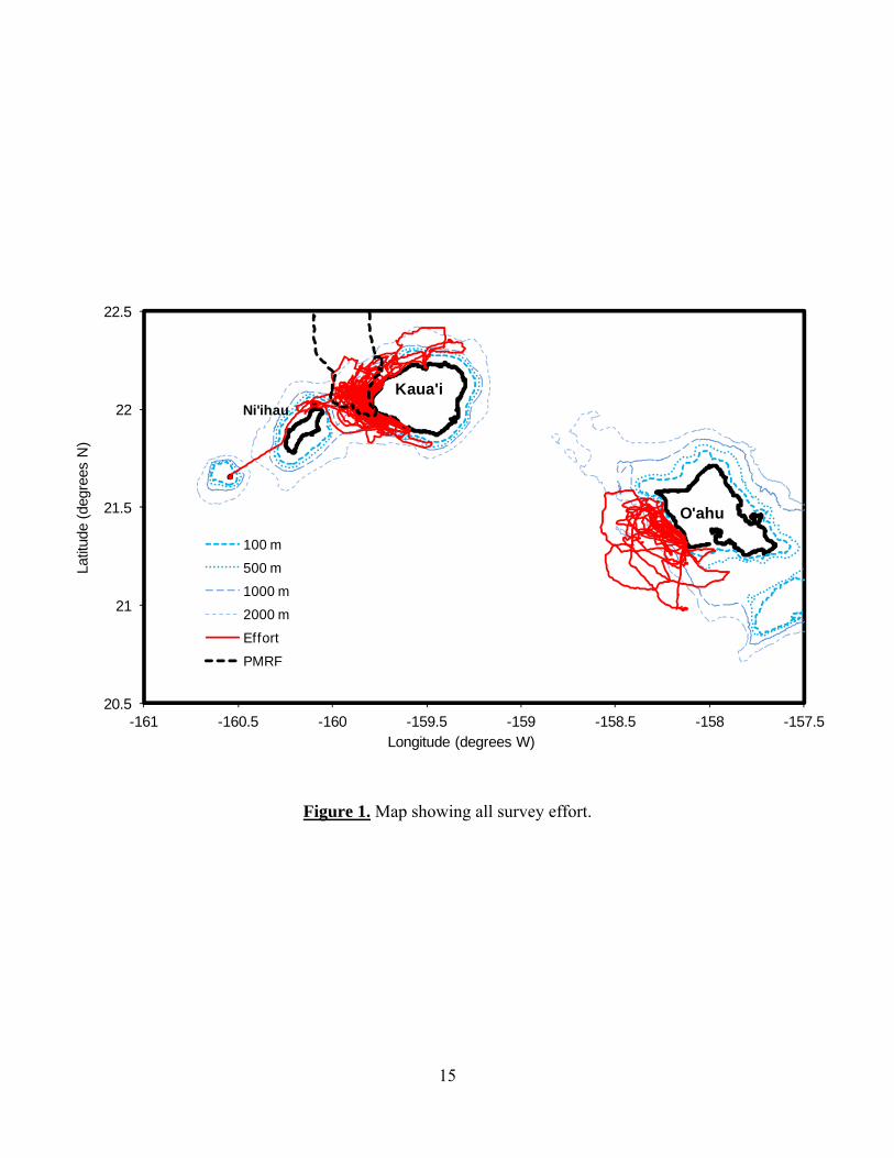
Overall survey effort Over the three years of the project surveys were undertaken on 66 days (406 hours), covering 6559 km (Table 1, Figure 1). Overall there were 191 odontocete sightings, 183 of which were identified to species. Off O‘ahu there were 30 sightings of 10 species (Table 2), while off Kaua‘i and Ni‘ihau there were 153 sightings of eight species (Table 3). One hundred and two biopsy samples were collected from seven different species (Tables 2, 3) for genetics 2 http://alaska.usgs.gov/science/biology/spatial/douglas.html

6
and toxicology studies. Sightings and effort data from these surveys have been incorporated into a larger analysis of relative abundance and habitat use for all species of Hawaiian odontocetes (Baird et al. 2013a), incorporating a total of 5450 hours and 84758 km of survey effort. Results from these specific surveys are consistent with the trends evident from the complete data set, in particular with relatively few sightings of pantropical spotted dolphins (Stenella attenuata) and a high proportion of sightings of rough-toothed dolphins off Kaua‘i and Ni‘ihau in comparison to off O‘ahu (Tables 2, 3; see Baird et al. 2013a). Over the three years of effort 30 satellite tags were deployed on five species (Table 4). Tag and photo-identification data are addressed for each of the tagged species below. We were unable to deploy satellite tags on three target species that were encountered (i.e., Blainville’s beaked whales (Mesoplodon densirostris), melon-headed whales (Peponocephala electra), and killer whales (Orcinus orca)) due to the small number of encounters (Tables 2, 3) and the difficulty in closely approaching these species. We had one sighting of killer whales off Kaua‘i on 24 July 2011, a group of four individuals first seen chasing a rough-toothed dolphin. This was only the second sighting of this species in Hawaiian waters in surveys which first began in 2000 (Baird et al. 2013a). We were able to photo-identify all individuals present, but there were no matches to our photo-identification catalog of this species in Hawai‘i (Baird et al. 2006). Combined with the relative infrequency of sighting of this species, this suggests these individuals are part of an open-ocean population.
Pygmy killer whales
Pygmy killer whales are one of the least known species of delphinids world-wide. The first live animal known to be of this species was harpooned off Japan only in 1952 (Yamada 1954), and they are naturally rare throughout their range. In Hawaiian waters they were first documented in the wild in 1963 (Pryor et al. 1965) and are relatively rare; they represented only 1.7% of odontocete sightings in the Baird et al. (2013a) analyses, encountered less often than any of the other 10 species of resident odontocetes. Photo-identification efforts in Hawai‘i have revealed the existence of a small population off the island of Hawai‘i that exhibits site fidelity (McSweeney et al. 2009). During our efforts we had three sightings of this species, all off O‘ahu in 2010. Three tags were deployed on pygmy killer whales, on individuals in two different groups. Two of the individuals were tagged off O‘ahu in the same group, although the tags were deployed five days apart. When this group was first encountered identification photos were obtained from 15 distinctive individuals, 12 of which (80%) had been previously documented off the island of O‘ahu in from two to four different years. Both of the tagged whales had been previously photographed off O‘ahu together in October 2008 and August 2009, and both were photographed together in December 2010 after the tags had come off. Three other individuals present in the group had also been previously photo-identified off O‘ahu in 2007, 2008, and 2009 (the latter two years with the two whales who were tagged also present). All 15 distinctive individuals have been subsequently documented off Oʻahu in from one to three different years. Combined this suggests this group is resident to the area. Satellite data from the two individuals combined were available for 30 days post-tagging. The group moved from the southwest coast of O‘ahu to off the south coast, and then spent the majority of their time in a small area off the western edge of Penguin Bank (Figure 2). Although they were an average of 44 km offshore, the group was documented almost entirely in depths of less than 1000 m (median depth of location = 576 m; Table 6). Identification photos were available from 17 distinctive individuals from the second group tagged, and two of those individuals (11.8%) had been previously documented, one off the island of Hawai‘i and one off Lāna‘i. The movement of one individual from Hawai‘i to O‘ahu represents the first inter-island movement documented from photo-identification data for this species. Prior to this effort movement data were available from just two pygmy killer
7
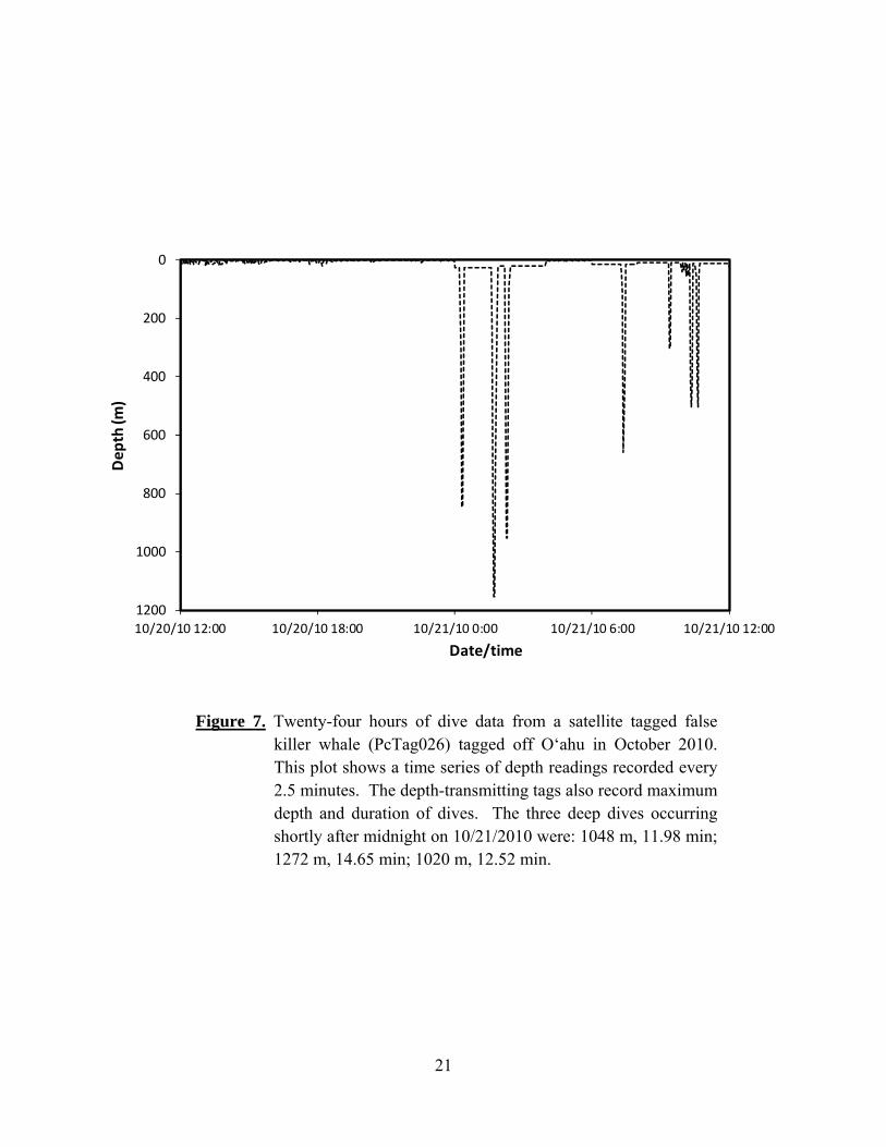
whales tagged off the island of Hawai‘i. Both individuals were part of the same social group although they were tagged four months apart, and both individuals remained strongly associated with the island (Baird et al. 2011a). The overall low re-sighting rate and lack of previous records from O‘ahu suggest the second group we tagged is not resident to the island. Satellite data from this group over a seven day period showed a very different pattern than the first group tagged, with repeated movements from less than 1000 m depth to over 3000 m depth (Figure 3). Overall this group used a much broader range of water depths with a median depth of 2487 m. Combined the results suggest that habitat use may depend strongly on whether the area is a core area for the group (e.g., O‘ahu/Penguin Bank for FaTag005 and FaTag006) versus an area visited only rarely (FaTag007). False killer whales Three populations of false killer whales have been recognized from Hawaiian waters: a pelagic population; and two insular populations, one that inhabits the main Hawaiian Islands and one that inhabits the Northwestern Hawaiian Islands (NWHI). These populations have been recognized based on a combination of genetic, photo-identification, and location data (Baird et al. 2008c, 2013b; Chivers et al. 2010; Oleson et al. 2010). We encountered false killer whales off O‘ahu in 2010 and Kaua‘i in 2012. During the first encounter off O‘ahu, 20 distinctive individuals were photo-identified, all of which were re-sightings of animals previously cataloged from the main Hawaiian Islands insular population (part of “Cluster 3”, a rarely seen group). (See Baird et al. 2012a.) During the second encounter off O‘ahu 10 distinctive individuals were photo-identified, all of which had been previously documented and were also members of the main Hawaiian Islands insular population (part of “Cluster 1”, the most commonly seen group). Tag data were obtained from three individuals (one from “Cluster 3” and two from “Cluster 1”) over periods ranging from 13 to 51 days (Table 4), and showed wide-ranging movements from O‘ahu to Hawai‘i Island (Figure 4). Data from these three individuals have been combined with satellite tag data from other individuals from this population to assess high-use areas for consideration for critical habitat designation (Baird et al. 2012a). Off Kaua‘i in June 2012 false killer whales were encountered two days in a row; during the first encounter 10 distinctive individuals were photo-identified, while during the second encounter 12 distinctive individuals were photo-identified, two of which were also present in the first encounter. None of these individuals had been previously documented in our photo-identification efforts in Hawaiian waters. Eleven biopsy samples were obtained from the two encounters and sent to the Southwest Fisheries Science Center for analyses. All 11 samples were “haplotype 1”, the primary haplotype found in insular populations both in the main Hawaiian Islands and Northwestern Hawaiian Islands (K. Martien, pers. comm.), indicating these individuals were not likely part of the pelagic population. Combined with the lack of photographic matches to the main Hawaiian Islands insular population, this evidence suggests the individuals were part of the Northwestern Hawaiian Islands population. Three individuals were satellite tagged from these groups, with data obtained for from 16 to 42 days. During this period the tagged individuals moved to the northwest of Kaua‘i as far as Gardner Pinnacles (Figure 5). Prior to these encounters satellite tag data were available from two individuals from this population, tagged in 2010 off Nīhoa (Baird et al. 2013b). Thus this represents a considerable increase in information available on movements and habitat use of individuals from this population. During the period of tag overlap all three individuals tagged in 2012 remained in close proximity; thus for comparison with the individuals tagged in 2010, only a single individual (PcTag034, the longest tag attachment) is considered. In general, water depth,

8
distance to shore, and distance to the 200 m isobaths were similar for PcTag034 and the two individuals tagged in 2010 (Table 5). In our previous surveys off Kaua‘i and Ni‘ihau in 2003, 2005, and 2008, no false killer whales had been encountered. However, prior to our 2012 encounters off Kaua‘i, it was known that individuals from the NWHI population at least occasionally visited Kaua‘i, based on matches of four individuals opportunistically photo-identified off Kaua‘i (all in 2008) to individuals documented in the NWHI population (Baird et al. 2013b). Based on satellite tags deployed elsewhere in the islands, individuals from the main Hawaiian Island insular population are also known to at least occasionally visit Kaua‘i and Ni‘ihau (Baird et al. 2012a). A plot of locations from the individuals tagged in 2012 and tagged individuals from the main Hawaiian Islands insular population that have moved around Kaua‘i and Ni‘ihau (Figure 6) indicate that this area of overlap between the two insular populations includes both the north and west sides of Kaua‘i and Ni‘ihau. Three of the six tags deployed on false killer whales were depth-transmitting satellite tags, two deployed on individuals from the main Hawaiian Islands population (one individual from each of “Cluster 1” and “Cluster 3”) and one on an individual from the Northwestern Hawaiian Island population. Dive data totaling 12.87 days were obtained from the two main Hawaiian individuals (7.39 and 5.47 days, respectively), and 6.59 days from the NWHI individual, providing the first dive data available from the NWHI population and the first long time series of dive data from the MHI population. (See Ligon and Baird 2001.) Data from these three depth-transmitting tags will be combined with data obtained from false killer whales tagged off Hawai‘i Island for a comprehensive examination of false killer whale diving behavior (Baird et al. in prep), but several things are worth noting. An example of 24 hours of dive data from PcTag026, tagged off O‘ahu in October 2010 (Figure 7), shows that, while the tagged individual spent the vast majority of its time in the top 50 m of the water column, deep dives (maximum 1272 m) were documented, both during the day and night. Bottlenose dolphins Previous studies have revealed the existence of four demographically-independent populations of bottlenose dolphins among the main Hawaiian Islands, which have been recognized as distinct stocks (Carretta et al. 2013), with populations off Kaua‘i and Ni‘ihau, O‘ahu, in the Maui Nui area, and off Hawai‘i Island (Baird et al. 2009; Martien et al. 2011). During our efforts off O‘ahu we only encountered a single group of bottlenose dolphins, but were able to photo-identify 10 individuals, five of which had been previously documented off O‘ahu (two in 2002, three in 2007), suggesting that the individuals were part of the resident O‘ahu population. Off Kaua‘i and Ni‘ihau we had 34 encounters with bottlenose dolphins, and obtained 114 identifications of 65 distinctive and very distinctive individuals. All 65 individuals linked by association in the main cluster of the social network, with many of the individuals first documented off Kaua‘i or Ni‘ihau in previous efforts in 2003 or 2005, suggesting that all groups photographically documented were part of the resident island-associated population. We were able to deploy satellite tags on three individuals off Kaua‘i, one in 2011 and two in 2012 (Table 4). One of the individuals tagged in 2012 (TtTag004) had been previously photo-identified off Kaua‘i in 2011, and both of the other individuals have been photo-identified off Kaua‘i subsequently. All three were linked by association within the main cluster of the social network (Figure 8). Movement data obtained for periods from 15 to 34 days showed all three individuals restricted to relatively near-shore and shallow waters (median depths of 88-332 m) around the
9
island of Kaua‘i (Figure 9; Table 7). Although individuals moved cumulative distances ranging from 1214 to 2016 km, on average they remained within from 10 to 40 km of their tagging locations. (Maximum straight-line distance from the tagging location was 61.4 km (Table 7)). None of the individuals was documented moving from Kaua‘i to Ni‘ihau, although, based on photo-identification, movements between those islands do occur (Baird et al. 2009). Results both from photo-identification and satellite tagging support previous studies that indicate a resident island-associated and demographically-isolated population of bottlenose dolphins off Kaua‘i and Ni‘ihau. Rough-toothed dolphins A single stock of rough-toothed dolphins is currently recognized from Hawaiian waters (Carretta et al. 2013), although results from photo-identification suggest that individuals exhibit some site fidelity to specific islands and that movements between the Kaua‘i/Ni‘ihau area and Hawai‘i Island are limited (Baird et al. 2008b). In the Baird et al. (2008b) examination of re-sightings and movements of photo-identified rough-toothed dolphins in Hawai‘i there were only six identifications of distinctive individuals from O‘ahu, none of which had been re-sighted. We encountered three groups of rough-toothed dolphins off O‘ahu in 2010 and were able to photo-identify individuals in each group. In all three encounters individuals documented had been previously photographed off O‘ahu, either from 2003 or from 2007, the first evidence for site fidelity of rough-toothed dolphins off O‘ahu.
Rough-toothed dolphins were sighted on 75 occasions off Kaua‘i and Ni‘ihau, by far the most frequently encountered species of odontocete in this study (Table 3). Seven individuals were satellite tagged off Kaua‘i. These are the first deployments of satellite tags on free-ranging rough-toothed dolphins anywhere in the world; previous satellite tagging of this species has been limited to animals that had stranded and were rehabilitated and released, with tags surgically attached (Wells et al. 2008). All tagged individuals were photo-identified, and four of the seven tagged individuals had been previously documented off Kaua‘i and/or Ni‘ihau, in 2005, 2007, or 2008. One of the individuals, HISb0431 (SbTag004), was first documented off Kaua‘i in 2005, was photo-identified off Hawai‘i Island in 2006, and then again off Kaua‘i in 2011 and 2012. This was one of the two individuals Baird et al. (2008b) had documented moving between Kaua‘i and Hawai‘i Islands. The return of this individual to Kaua‘i, as well as the other individual documented moving among islands (which was re-sighted in August 2011 off Kaua‘i), indicates that the inter-island movements documented were not permanent dispersal events.
All of the satellite tagged individuals were linked by association in the main cluster of the
social network (Figure 10), indicating they are part of the island-associated population. Two of the individuals, tagged in the same group in August 2011 (SbTag002 and SbTag003), remained relatively close together during the period of tag overlap (median = 1.06 km; see Baird et al. 2012b), suggesting they were from a single social group. Location data were obtained from the seven tags for periods ranging from 5.9 to 27.5 days; during these periods all of the tagged individuals remained generally associated with the slope waters of Kaua‘i and Ni‘ihau (Figure 11; Table 8). Cumulative distances moved by individuals ranged from 424 to 2174 km, yet individuals remained an average of 10.3 to 51.9 km from their tagging locations, with the maximum straight-line distance from the tagging location of 103.1 km (Table 8). These results corroborate the evidence of site fidelity from photo-identification data (Baird et al. 2008b), indicating that these individuals appear to be an island-associated resident population.

10
During our efforts we collected eight genetic samples from rough-toothed dolphins off O‘ahu and 32 samples from rough-toothed dolphins off Kaua‘i and Ni‘ihau; these samples have been contributed to a study of population genetics being undertaken as part of a Ph.D. project through Oregon State University. Preliminary results from this work suggest that populations off Kaua‘i and Hawai‘i are demographically isolated (R. Albertson, pers. comm.). Short-finned pilot whales A single stock of short-finned pilot whales is currently recognized from Hawaiian waters (Carretta et al. 2013). Photo-identification efforts off the island of Hawai‘i have indicated a high degree of site fidelity, at least for some groups, and provided some evidence that there may be more than one population of short-finned pilot whales in Hawaiian waters (Mahaffy et al. in review). During our study, pilot whales were encountered four times off O‘ahu and eight times off Kaua‘i and Ni‘ihau (Tables 2, 3), and seven genetic samples were obtained. These samples have been contributed to a Ph.D. study on pilot whale population genetics being undertaken at Scripps Institution of Oceanography. Off O‘ahu there were two encounters one day apart (15 and 16 October 2010) where 30 distinctive individuals were photo-identified; of those, six individuals were in common between the two encounters. None of the 30 individuals had been previously photo-identified off O‘ahu, although six individuals had been previously documented off Lāna‘i in 2000. An analysis of association data from all short-finned pilot whales photo-identified around the main Hawaiian Islands from 2000 through 2012 showed this group was an isolated cluster, with no links to the main components of the social network (not shown). Three satellite tags were deployed on individuals in these two encounters, with the tags transmitting for periods spanning from 22.8 to 228.2 days. This latter tag deployment is the longest duration span of location data obtained from any of the 182 satellite tags deployed on Hawaiian odontocetes since 2007 (Cascadia Research Collective, unpublished). Based on an analysis of distance between the locations of the three tagged individuals (see Baird et al. 2011b), two of the individuals were acting in concert (GmTag042 and GmTag043), with a median distance between locations during the same satellite overpass of 3.0 km, while the other individual appeared to be acting independently. During the periods of tag attachments the tagged individuals remained strongly associated with O‘ahu and the Maui Nui area for the entire duration of tag transmissions (Figure 12). Most of the time was spent off the leeward (west) shores of Lāna‘i and the south and west shores of O‘ahu, with relatively little time spent on the north side of O‘ahu or north of the 4-island area. Tagged individuals from this group were strongly associated with the slope, with most locations in depths of less than 3000 m (GmTag041 median = 1128 m, GmTag042 median = 1330 m, GmTag043 median =1247 m; Table 9). Maximum distance moved from the tagging location for these individuals was 190 km. The relative lack of movements, strong association with the slope, and large proportion of individuals that had been previously photo-identified suggest this is a resident group to the O‘ahu/Maui Nui area. The lack of previous (or subsequent) sightings of this group off O‘ahu, however, suggests that it may spend the majority of its time elsewhere, e.g., off Maui Nui.
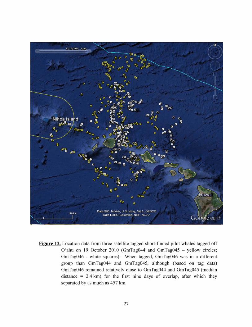
The remaining two encounters off O‘ahu were on a single day (19 October 2010), with the two groups separated by approximately 1 km when the second group was encountered. In the first encounter 20 distinctive individuals were photo-identified, none of which had been previously documented; two satellite tags were deployed on individuals in this group (GmTag044, GmTag045, see Table 4). In the second encounter, 14 distinctive individuals were photo-identified, four of which had been previously photo-identified off Kaua‘i in 2008. One individual from the second group was satellite tagged (GmTag046). An analysis of association

11
data from all short-finned pilot whales photo-identified around the main Hawaiian Islands from 2000 through 2012 showed that both of these groups were isolated clusters, i.e., with no links to the main components of the social network. For the first nine days after tagging the tagged individuals remained in relatively close proximity (median = 2.4 km), after which GmTag046 separated. After the first nine days the median distance apart was 164 km (maximum = 457 km). These individuals ranged widely, both among the western main Hawaiian Islands almost as far as Nīhoa in the northwestern Hawaiian Islands, and offshore (Figure 13), with one individual crossing into international waters. Average water depth used by these three individuals was more than three times the depth used by the individuals tagged on 15 and 16 October 2010 (Table 9). The movements of these three individuals, in contrast to those tagged on 15 and 16 October 2010, suggest they are part of a widely ranging open-ocean population of this species, rather than an island-associated population.
Short-finned pilot whales were encountered on eight occasions off Kaua‘i in 2011 and
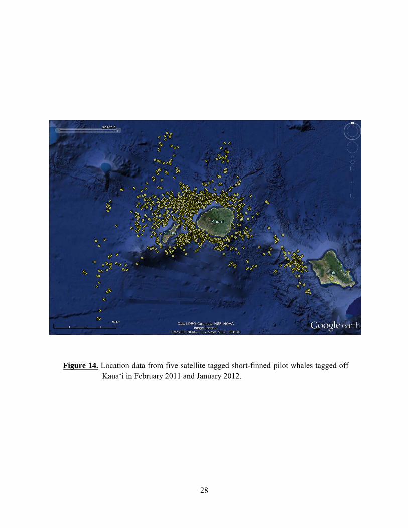
2012. Sixty-five identifications of 50 distinctive individuals were obtained, 27 of which had been previously documented either off Kaua‘i or off southwestern O‘ahu. Individuals from all groups encountered were linked by association in a single social network, the main component of the social network of pilot whales documented off Kaua‘i and O‘ahu (not shown). Five satellite tags were deployed on pilot whales off Kaua‘i on three different days (three on 18 and 19 February 2011, and two on 14 January 2012). Four of the five individuals tagged had either been previously or subsequently photo-identified off southwestern O‘ahu. Based on analyses of associations, the three tags deployed in February 2011 were on individuals from three different social groups (termed clusters; see Mahaffy et al. in review), while the two tags deployed in January 2012 were on one social group (cluster W6), which had also had one individual tagged in February 2011 (GmTag050). Location data from these five tags were obtained over periods from 11.7 to 73.3 days (Table 4). Two of the five tagged individuals, one in each year (GmTag051 and GmTag063), ranged both around Kaua‘i and Ni‘ihau with movements to the southeast as far as the eastern tip of O‘ahu (Figure 14). General conclusions Our efforts substantially increased what is known about the movements and habitat use of five species of odontocetes in the western main Hawaiian Islands: pygmy killer whales, false killer whales, bottlenose dolphins, rough-toothed dolphins, and short-finned pilot whales. For all five species, satellite tag data indicate that there are island-associated populations, although how these species use the habitat varies, with some restricted primarily to near-shore shallow waters (i.e., bottlenose dolphins), while others primarily use slope waters. For one species, short-finned pilot whales, tag and photo-identification data suggest three broadly overlapping populations around or in the study area: an open-ocean population and two island-associated populations, one which uses the area from Ni‘ihau to western O‘ahu, and the other that uses the larger area around O‘ahu and Maui Nui.
Acknowledgments
In addition to funding from the Navy’s Living Marine Resources Program through the Naval Postgraduate School, we would like to thank Commander, Pacific Fleet and the NOAA Pacific Islands Fisheries Science Center for funding support. The February 2011 cruise was organized by Sean Hanser and Morgan Richie of Naval Facilities, Pacific. We thank the Marine Mammal Monitoring on Navy Ranges (M3R) program, in particular Nancy Dimarzio, Ashley
12
Dilley, Scott Fisher, Susan Jarvis, Dave Moretti, and Ron Morrissey, for directing us to acoustic detections on the PMRF range. Don Moses, Dan McSweeney, Tara Leota, Shawn Hunadi, and Kevin Anderson provided vessel assistance, and a number of people assisted in the field, particularly Renee Albertson, Michele Bane, and Jochen Zaeschmar. We would like to thank a number of individuals for contributing photos to our catalogs, in particular off the island of O‘ahu, where sampling efforts have been limited: Tori Cullins/Wild Dolphin Foundation, Jim Ward, Alicia Franco, Chuck Babbitt, and Kelly Wright. We thank Renee Albertson/Oregon State University for providing sex determinations for tagged rough-toothed dolphins, and Karen Martien and Kelly Robertson of the Southwest Fisheries Science Center for providing information on population identity and/or sex of false killer whales and tagged individuals of other species, and Damon Holzer of the Northwest Fisheries Science Center for GIS analyses. Research was undertaken under NMFS Scientific Research Permits No. 731-1774 and 15330 issued to RWB and 774-1714 issued to the Southwest Fisheries Science Center.
Literature Cited
Baird, R. W., D. J. McSweeney, C. Bane, J. Barlow, D. R. Salden, L. K. Antoine, R. G. LeDuc, and D. L. Webster. 2006. Killer whales in Hawaiian waters: information on population identity and feeding habits. Pacific Science 60:523-530.
Baird, R. W., G. S. Schorr, D. L. Webster, D. J. McSweeney, M. B. Hanson, and R. D. Andrews. 2008a. Multi-species cetacean satellite tagging to examine movements in relation to the 2008 Rim-of-the-Pacific (RIMPAC) naval exercise. A quick look report on the results of tagging efforts undertaken under Order No. D1000115 from the Woods Hole Oceanographic Institution. Available from: http://www.cascadiaresearch.org/hawaii/publications.htm.
Baird, R. W., D. L. Webster, S. D. Mahaffy, D. J. McSweeney, G. S. Schorr, and A. D. Ligon. 2008b. Site fidelity and association patterns in a deep-water dolphin: rough-toothed dolphins (Steno bredanensis) in the Hawaiian Archipelago. Marine Mammal Science 24:535-553.
Baird, R. W., A. M. Gorgone, D. J. McSweeney, D. L. Webster, D. R. Salden, M. H. Deakos, A. D. Ligon, G. S. Schorr, J. Barlow, and S. D. Mahaffy. 2008c. False killer whales (Pseudorca crassidens) around the main Hawaiian Islands: long-term site fidelity, inter-island movements, and association patterns. Marine Mammal Science 24:591-612.
Baird, R. W., A. M. Gorgone, D. J. McSweeney, A. D. Ligon, M. H. Deakos, D. L. Webster, G. S. Schorr, K. K. Martien, D. R. Salden, and S. D. Mahaffy. 2009. Population structure of island-associated dolphins: evidence from photo-identification of common bottlenose dolphins (Tursiops truncatus) in the main Hawaiian Islands. Marine Mammal Science 25:251-274.
Baird, R. W., G. S. Schorr, D. L. Webster, D. J. McSweeney, M. B. Hanson, and R. D. Andrews. 2011a. Movements of two satellite-tagged pygmy killer whales (Feresa attenuata) off the island of Hawai‘i. Marine Mammal Science 27:E332-E337.
Baird, R. W., G. S. Schorr, D. L. Webster, S. D. Mahaffy, J. M. Aschettino, and T. Cullins. 2011b. Movements and spatial use of satellite-tagged odontocetes in the western main Hawaiian Islands: results of field work undertaken off O‘ahu in October 2010 and Kaua‘i in February 2011. Annual progress report under Grant No. N00244-10-1-0048 from the Naval Postgraduate School. Available from: http://www.cascadiaresearch.org/hawaii/publications.htm.

13
Baird, R. W., M. B. Hanson, G. S. Schorr, D. L. Webster, D. J. McSweeney, A. M. Gorgone, S. D. Mahaffy, D. Holzer, E. M. Oleson, and R. D. Andrews. 2012a. Assessment of range and primary habitats of Hawaiian insular false killer whales: a scientific basis for determination of "critical habitat." Endangered Species Research 18:47-61.
Baird, R. W., D. L. Webster, G. S. Schorr, J. M. Aschettino, A. M. Gorgone, and S. D. Mahaffy. 2012b. Movements and spatial use of odontocetes in the western main Hawaiian Islands: results from satellite-tagging and photo-identification off Kaua‘i and Ni‘ihau in July/August 2011. Annual progress report under Grant No. N00244-10-1-0048 from the Naval Postgraduate School. Available from: http://www.cascadiaresearch.org/hawaii/publications.htm.
Baird, R. W., D. L. Webster, J. M. Aschettino, G. S. Schorr, and D. J. McSweeney. 2013a. Odontocete cetaceans around the main Hawaiian Islands: habitat use and relative abundance from small-boat sighting surveys. Aquatic Mammals 39:253-269.
Baird, R. W., E. M. Oleson, J. Barlow, A. D. Ligon, A. M. Gorgone, and S. D. Mahaffy. 2013b. Evidence of an island-associated population of false killer whales (Pseudorca crassidens) in the Northwestern Hawaiian Islands. Pacific Science 67:513-521.
Barlow, J. 2006. Cetacean abundance in Hawaiian waters estimated from a summer/fall survey in 2002. Marine Mammal Science 22:446-464.
Carretta, J. V., E. Oleson, D. W. Weller, A. R. Lang, K. A. Forney, J. Baker, B. Hanson, K. Martien, M. M. Muto, M. S. Lowry, J. Barlow, D. Lynch, L. Carswell, R. L. Brownell Jr., D. K. Mattila, and M. C. Hill. 2013. U.S. Pacific marine mammal stock assessments: 2012. NOAA Technical Memorandum NMFS-SWFSC-504.
Chivers, S. J., R. W. Baird, K. M. Martien, B. L. Taylor, E. Archer, A. M. Gorgone, B. L. Hancock, N. M. Hedrick, D. Matilla, D. J. McSweeney, E. M. Oleson, C. L. Palmer, V. Pease, K. M. Robertson, J. Robbins, J. C. Salinas, G. S. Schorr, M. Schultz, J. L. Theileking, and D. L. Webster. 2010. Evidence of genetic differentiation for Hawai‘i insular false killer whales (Pseudorca crassidens). NOAA Technical Memorandum NMFS-SWFSC-458.
Douglas, D. C., R. Weinzierl, S. C. Davidson, R. Kays, M. Wikelski, and G. Bohrer. 2012. Moderating Argos location errors in animal tracking data. Methods in Ecology and Evolution 6:999-1007.
Ligon, A. D., and R. W. Baird. 2001. Diving behaviour of false killer whales off Maui and Lanai, Hawaii. Page 126 in: Abstracts of the 14th Biennial Conference on the Biology of Marine Mammals. Vancouver, British Columbia, November-December 2001.
Mahaffy, S. D., R. W. Baird, D. J. McSweeney, D. L. Webster, and G. S. Schorr. In review. High site fidelity, strong associations and long-term bonds: short-finned pilot whales off the island of Hawai‘i. Submitted to: Marine Mammal Science.
Martien, K. K., R. W. Baird, N. M. Hedrick, A. M. Gorgone, J. L. Thieleking, D. J. McSweeney, K. M. Robertson, and D. L. Webster. 2011. Population structure of island-associated dolphins: evidence from mitochondrial and microsatellite markers for common bottlenose dolphins (Tursiops truncatus) around the main Hawaiian Islands. Marine Mammal Science, doi: 10.1111/j.1748-7692.2011.00506.x.
McSweeney, D. J., R. W. Baird, S. D. Mahaffy, D. L. Webster, and G. S. Schorr. 2009. Site fidelity and association patterns of a rare species: pygmy killer whales (Feresa attenuata) in the main Hawaiian Islands. Marine Mammal Science 25:557-572.
Oleson, E. M., C. H. Boggs, K. A. Forney, M. B. Hanson, D. R. Kobayashi, B. L. Taylor, P. R. Wade, and G. M. Ylitalo. 2010. Status review of Hawaiian insular false killer whales (Pseudorca crassidens) under the Endangered Species Act. NOAA Tech. Mem. NMFS-PIFSC-22.

14
Pryor, T., K. Pryor, and K. S. Norris. 1965. Observations on a pygmy killer whale (Feresa attenuata Gray) from Hawaii. Journal of Mammalogy 46:450-461.
Wells, R. S., G. A. Early, J. G. Gannon, R. G. Lingenfelser, and P. Sweeney. 2008. Tagging and tracking of rough-toothed dolphins (Steno bredanensis) from the March 2005 mass stranding in the Florida Keys. NOAA Tech. Mem. NMFS-SEFSC-574.
Yamada, M. 1954. An account of a rare porpoise, Feresa Gray from Japan. Scientific Reports of the Whales Research Institute 9:59-88.
15
20.5
21
21.5
22
22.5
-161 -160.5 -160 -159.5 -159 -158.5 -158 -157.5
Latit
ude
(deg
rees
N)
Longitude (degrees W)
100 m
500 m
1000 m
2000 m
Effort
PMRF
Kaua'iNi'ihau
O'ahu
Figure 1. Map showing all survey effort.

16
Figure 2. Locations of two satellite tagged pygmy killer whales (FaTag005 and FaTag006) tagged off O‘ahu in October 2010 and tracked over a 30-day period. These two individuals are thought to be resident to the Oʻahu/Maui Nui area.

17
Figure 3. Locations of a satellite tagged pygmy killer whale tagged off O‘ahu 24 October 2010 (FaTag007) and tracked over a 7.2-day period. This individual is not thought to be resident to the Oʻahu area.

18
Figure 4. Locations from three satellite tagged false killer whales from the main Hawaiian Islands insular population tagged off O‘ahu in October 2010 and tracked over periods of 13.2 to 51.3 days.

19
Figure 5. Locations of three tagged false killer whales from the Northwestern Hawaiian Islands population tagged off Kaua‘i in June 2012 over periods from 16.6 to 42.1 days. The boundary of the Papahanaumokuakea Marine National Monument is shown (solid yellow line), as is the U.S. Exclusive Economic Zone (solid blue line).

20
Figure 6. Overlap of satellite-derived locations from individuals from the main Hawaiian Islands insular stock and the individuals tagged in June 2012.
21
0
200
400
600
800
1000
120010/20/10 12:00 10/20/10 18:00 10/21/10 0:00 10/21/10 6:00 10/21/10 12:00
Depth (m
)
Date/time
Figure 7. Twenty-four hours of dive data from a satellite tagged false killer whale (PcTag026) tagged off O‘ahu in October 2010. This plot shows a time series of depth readings recorded every 2.5 minutes. The depth-transmitting tags also record maximum depth and duration of dives. The three deep dives occurring shortly after midnight on 10/21/2010 were: 1048 m, 11.98 min; 1272 m, 14.65 min; 1020 m, 12.52 min.

22
Figure 8. The main cluster of the social network of bottlenose dolphins off Kaua‘i and Ni‘ihau, with the tagged individuals indicated. This cluster contains 177 individuals photo-identified between 2003 and 2012, including those considered slightly distinctive, distinctive, or very distinctive.

23
Figure 9. Location data from three satellite tagged bottlenose dolphins tagged off Kaua‘i in 2011 and 2012, with data available for periods ranging from 15 to 32 days. (See Table 4.)

24
Figure 10. Social network of rough-toothed dolphins photo-identified off Kaua‘i and Ni‘ihau from 2003 through 2012, with tagged individuals indicated. There are 350 individuals represented, with 308 (88%) linked by association in the main cluster of the social network.

25
Figure 11. Location data from seven satellite tagged rough-toothed dolphins tagged off Kaua‘i in 2011 and 2012, with data available for periods from 5.9 to 27.5 days.

26
Figure 12. Location data from three satellite tagged short-finned pilot whales tagged off O‘ahu on 15 and 16 October 2010 (GmTag041, GmTag042, GmTag043). Individuals present during these encounters had been previously photo-identified off Lāna‘i in 2000. The gap in distance between the cluster of points north of Maui and those off O‘ahu reflect multi-day intervals due to duty cycling after the first 60 days of transmission.
27
Figure 13. Location data from three satellite tagged short-finned pilot whales tagged off O‘ahu on 19 October 2010 (GmTag044 and GmTag045 – yellow circles; GmTag046 - white squares). When tagged, GmTag046 was in a different group than GmTag044 and GmTag045, although (based on tag data) GmTag046 remained relatively close to GmTag044 and GmTag045 (median distance = 2.4 km) for the first nine days of overlap, after which they separated by as much as 457 km.
28
Figure 14. Location data from five satellite tagged short-finned pilot whales tagged off Kaua‘i in February 2011 and January 2012.

29
Table 1. Summary of research effort by year.
Year Islands # vessel
days # hours on
effort # km on
effort Primary vessel
used 2010 O‘ahu 14 096 1385 8.2 m Whaler 2011 Kaua‘i/Ni‘ihau 23 152 2411 8.2 m Whaler 2012 Kaua‘i/Ni‘ihau 29 158 2763 7.3 m RHIB
Total, all islands 66 406 6559 Table 2. Summary of odontocete sightings off O‘ahu in October 2010. For those species where
satellite tags were deployed, name abbreviations are given in italics. (Refer to Table 4.)
Species No. of sightings
Group size (range)
# genetic samples
# satellite tags deployed
# photos
Blainville’s beaked whale 02 3-4 00 0 0339Bottlenose dolphin 01 19 02 0 0258 Dwarf sperm whale 01 1 00 0 0000False killer whale (Pc) 02 19-28 04 3 3467Melon-headed whale 01 1 00 0 0002 Pantropical spotted dolphin 11 11-170 10 0 1888Pygmy killer whale (Fa) 03 17-25 03 3 4538Rough-toothed dolphin 03 14-24 08 0 2481 Short-finned pilot whale (Gm)
04 32-56 05 6 5396
Spinner dolphin 02 25-55 00 0 0294 Table 3. Summary of odontocete sightings off Kaua‘i and Ni‘ihau in 2011 and 2012. For those
species where satellite tags were deployed, name abbreviations are given in italics. (Refer to Table 4.)
Species No. of
sightingsGroup
size ( )
# genetic samples
# satellite tags deployed
# photos
Blainville’s beaked whale 01 5 00 0 00099Bottlenose dolphin (Tt) 34 1-200 19 3 10714False killer whale (Pc) 02 18-19 11 3 04260 Killer whale 01 4 00 0 00779Pantropical spotted dolphin 04 1-25 01 0 00103Rough-toothed dolphin (Sb) 75 1-65 32 7 19215 Short-finned pilot whale (Gm)
08 5-85 02 5 05002
Spinner dolphin 28 2-120 05 0 07932

30
Table 4. Tag deployments by species.
Species Tag ID Individual ID Population ID1 Date tagged Duration (Days) Island Tag type Sex Fa FaTag 005 00HIFa368 O‘ahu resident 10/13/2010 011.81 O‘ahu Spot5 Female Fa FaTag 006 00HIFa371 O‘ahu resident 10/18/2010 025.47 O‘ahu Spot5 Female Fa FaTag 007 00HIFa459 Unknown 10/24/2010 007.16 O‘ahu Spot5 Unknown Gm GmTag 041 HIGm1291 O‘ahu /Lāna‘i resident 10/15/2010 022.83 O‘ahu Spot5 Male Gm GmTag 042 HIGm1296 O‘ahu /Lāna‘i resident 10/16/2010 097.50 O‘ahu Spot5 Male Gm GmTag 043 HIGm1297 O‘ahu /Lāna‘i resident 10/16/2010 228.27 O‘ahu Spot5 Male Gm GmTag 044 HIGm1317 Open ocean? 10/19/2010 057.99 O‘ahu Spot5 Male Gm GmTag 045 HIGm1324 Open ocean? 10/19/2010 009.31 O‘ahu Spot5 Male Gm GmTag 046 HIGm1187 Open ocean? 10/19/2010 053.09 O‘ahu Spot5 Male Gm GmTag 049 HIGm1374 Kaua‘i/O‘ahu resident 02/18/2011 030.93 Kaua‘i Spot5 Male Gm GmTag 050 HIGm0180 Kaua‘i/O‘ahu resident 02/18/2011 036.80 Kaua‘i Mk10-A Male Gm GmTag 051 HIGm1400 Kaua‘i/O‘ahu resident 02/19/2011 070.33 Kaua‘i Spot5 Male Gm GmTag 063 HIGm0209 Kaua‘i/O‘ahu resident 01/14/2012 073.26 Kaua‘i Spot5 Unknown Gm GmTag 064 HIGm0036 Kaua‘i/O‘ahu resident 01/14/2012 011.68 Kaua‘i Spot5 Male Pc PcTag 026 00HIPc200 MHI insular 10/15/2010 013.19 O‘ahu Mk10-A Male Pc PcTag 027 00HIPc132 MHI insular 10/22/2010 051.32 O‘ahu Spot5 Male Pc PcTag 028 00HIPc272 MHI insular 10/22/2010 047.61 O‘ahu Mk10-A Unknown Pc PcTag 034 00HIPc519 NWHI insular 06/13/2012 042.06 Kaua‘i Spot5 Unknown Pc PcTag 035 00HIPc520 NWHI insular 06/13/2012 021.45 Kaua‘i Mk10-A Male Pc PcTag 036 00HIPc533 NWHI insular 06/14/2012 016.62 Kaua‘i Spot5 Female Sb SbTag 001 HISb0860 Kaua‘i resident 07/31/2011 007.59 Kaua‘i Spot5 Unknown Sb SbTag 002 HISb0908 Kaua‘i resident 08/02/2011 012.52 Kaua‘i Spot5 Male Sb SbTag 003 HISb0785 Kaua‘i resident 08/02/2011 018.55 Kaua‘i Spot5 Male Sb SbTag 004 HISb0431 Kaua‘i resident 01/14/2012 027.51 Kaua‘i Spot5 Unknown Sb SbTag 005 HISb0938 Kaua‘i resident 06/17/2012 005.92 Kaua‘i Mk10-A Unknown Sb SbTag 006 HISb0933 Kaua‘i resident 07/01/2012 010.44 Kaua‘i Mk10-A Unknown Sb SbTag 007 HISb0362 Kaua‘i resident 07/02/2012 013.73 Kaua‘i Mk10-A Unknown Tt TtTag 002 HITt0632 Kaua‘i resident 08/03/2011 034.13 Kaua‘i Spot5 Male Tt TtTag 004 HITt0746 Kaua‘i resident 06/13/2012 015.09 Kaua‘i Spot5 Unknown Tt TtTag 005 HITt0782 Kaua‘i resident 06/24/2012 023.99 Kaua‘i Mk10-A Unknown
1Population ID based on various characteristics, including re-sighting history of individual and/or group encountered, genetics (for false killer whales), and tag data.

31
Table 5. Comparison of depth, distance to land, and distance to the 200 m isobath of one of the individual false killer whales tagged off Kaua‘i in June 2012 with two individuals tagged off Ni‘ihau in 2010 (from Baird et al. 2013b).
Tag ID Number
of locations
Water Depth (m) Distance to land (km) Distance to 200 m isobath (km)
Min. Median Max. Min. Median Max. Min. Median Max. PcTag024 034 22 1532 4082 7.1 38.6 104.1 0.10 04.1 034.7 PcTag025 337 09 2506 5127 2.0 55.0 147.5 0.02 17.1 089.9 PcTag034 501 17 0697 4631 1.0 52.7 245.6 0.10 05.2 106.1
Table 6. Movements and habitat of satellite tagged pygmy killer whales tagged off O‘ahu in 2010. FaTag005 was not included due to
the small sample size of locations. See Table 4 for additional information.
Tag ID Cumulative distance
moved (km)
Median distance from deployment
location (km)
Maximum distance from deployment
location (km)
Median distance from
shore (km)
Maximum distance from
shore (km)
Median depth (m)
Maximum depth (m)
FaTag006 1419.4 03.9 80.8 44.9 57.8 0576 2546 FaTag007 0587.6 26.1 45.7 22.9 52.2 2489 3754
Table 7. Movements and habitat of satellite tagged bottlenose dolphins tagged off Kaua‘i in 2011 and 2012. See Table 4 for
additional information.
Tag ID Cumulative distance
moved (km)
Median distance from deployment
location (km)
Maximum distance from deployment
location (km)
Median distance from
shore (km)
Maximum distance from
shore (km)
Median depth (m)
Maximum depth (m)
TtTag002 2016.6 39.9 61.4 2.5 14.1 088 2880 TtTag004 1214.7 39.5 56.2 3.3 15.7 332 2008 TtTag005 1774.6 10.0 56.8 4.1 16.9 244 1807

32
Table 8. Movements and habitat use of satellite tagged rough-toothed dolphins tagged off Kaua‘i in 2011 and 2012. See Table 4 for additional information.
Tag ID Cumulative distance
moved (km)
Median distance from deployment
location (km)
Maximum distance from deployment
location (km)
Median distance from
shore (km)
Maximum distance from
shore (km)
Median depth (m)
Maximum depth (m)
SbTag001 573.6 13.8 39.7 11.6 19.5 816 2162 SbTag002 809.8 10.3 30.2 12.2 21.5 1031 2762 SbTag003 1295.8 10.7 42.4 12.2 21.7 1107 2703 SbTag004 2174.5 51.9 103.1 13.0 40.7 1512 4460 SbTag005 424.5 18.1 56.6 10.9 27.2 1109 3971 SbTag006 594.6 11.3 37.5 10.4 17.8 752 2545 SbTag007 793.4 10.3 35.7 12.2 18.6 827 2247
Table 9. Movements and habitat use of satellite tagged short-finned pilot whales tagged off O‘ahu in 2010 or Kaua‘i in 2011 and 2012. See Table 4 for additional information.
Tag ID Cumulative distance
moved (km)
Median distance from deployment
location (km)
Maximum distance from deployment
location (km)
Median distance from
shore (km)
Maximum distance from
shore (km)
Median depth (m)
Maximum depth (m)
GmTag041 1150.0 114.6 148.7 018.0 047.5 1128 3208 GmTag042 3063.6 092.2 153.4 025.5 081.6 1330 4736 GmTag043 6109.5 083.2 190.3 022.5 067.6 1247 3881 GmTag044 5093.1 290.6 505.2 133.2 381.4 4607 4944 GmTag045 0987.6 262.2 425.2 065.4 171.4 4336 4701 GmTag046 4372.8 193.6 424.0 081.1 237.1 4318 4876 GmTag049 2309.5 066.3 246.1 027.4 140.4 3424 4729 GmTag050 1607.7 054.8 132.0 019.8 048.9 2589 4554 GmTag051 2306.9 045.1 190.1 017.6 058.8 2043 4438 GmTag063 4246.8 048.6 177.5 015.9 122.3 2033 4870 GmTag064 0866.5 027.3 078.6 012.2 035.8 1416 4375
33
Initial Distribution List 1. 2. 3. 4. 5. 6. 7.
Defense Technical Information Center 8725 John J. Kingman Rd., STE 0944 Ft. Belvoir, VA 22060-6218 Dudley Knox Library, Code 013 Naval Postgraduate School Monterey, CA 93943-5100 Erin Oleson National Marine Fisheries Service Pacific Islands Fisheries Science Center Honolulu, HI John Hildebrand Scripps Institution of Oceanography University of California La Jolla, CA John Calambokidis Cascadia Research Collective Olympia, WA Greg Schorr Cascadia Research Collective Olympia, WA Erin Falcone Cascadia Research Collective Olympia, WA
2 2 1 1 1 1 1

34
8. 9. 10. 11. 12. 13. 14. 15.
Ching-Sang Chiu Naval Postgraduate School Monterey, CA Curtis A. Collins Naval Postgraduate School Monterey, CA Thomas A. Rago Naval Postgraduate School Monterey, CA Tetyana Margolina Naval Postgraduate School Monterey, CA Chris Miller Naval Postgraduate School Monterey, CA John Joseph Naval Postgraduate School Monterey, CA Katherine Whitaker Pacific Grove, CA Frank Stone CNO(N45) Washington, D.C.
1 1 1 1 1 1 1 1

35
16. 17. 18. 19. 20. 21. 22. 23.
Jay Barlow Southwest Fisheries Science Center, NOAA La Jolla, CA CAPT Ernie Young, USN (Ret.) CNO(N45) Washington, D.C. Dale Liechty CNO(N45) Washington, D.C. Dave Mellinger Oregon State University Newport, OR Kate Stafford Applied Physics Laboratory University of Washington Seattle, CA Sue Moore NOAA at Applied Physics Laboratory University of Washington Seattle, WA Petr Krysl University of California La Jolla, CA Mark McDonald Whale Acoustics Bellvue, CO
1 1 1 1 1 1 1 1

36
24. 25. 26. 27. 28. 29. 30.
Ted Cranford San Diego State University San Diego, CA Monique Fargues Naval Postgraduate School Monterey, CA Mary Ann Daher Woods Hole Oceanographic Institution Woods Hole, MA Heidi Nevitt NAS North Island San Diego, CA Rebecca Stone Naval Postgraduate School Monterey, CA Sean M. Wiggins Scripps Institution of Oceanography University of California La Jolla, CA E. Elizabeth Henderson Scripps Institution of Oceanography University of California La Jolla, CA
1 1 1 1 1 1 1

37
31. 32. 33. 34. 35. 36. 37. 38.
Gregory S. Campbell Scripps Institution of Oceanography University of California La Jolla, CA Marie A. Roch San Diego State University San Diego, CA Anne Douglas Cascadia Research Collective Olympia, WA Julie Rivers COMPACFLT Pearl Harbor, HI Jenny Marshall Naval Facilities Engineering Command San Diego, CA Chip Johnson COMPACFLT Pearl Harbor, HI CDR Len Remias U.S. Pacific Fleet Pearl Harbor, HI LCDR Robert S. Thompson U.S. Pacific Fleet Pearl Harbor, HI
1 1 1 1 1 1 1 1

38
39. 40. 41. 42. 43. 44. 45. 46.
Jene J. Nissen U. S. Fleet Forces Command Norfolk, VA W. David Noble U. S. Fleet Forces Command Norfolk, VA David T. MacDuffee U. S. Fleet Forces Command Norfolk, VA Keith A. Jenkins Naval Facilities Engineering Command, Atlantic Norfolk, VA Joel T. Bell Naval Facilities Engineering Command, Atlantic Norfolk, VA Mandy L. Shoemaker Naval Facilities Engineering Command, Atlantic Norfolk, VA Anurag Kumar Naval Facilities Engineering Command, Atlantic Norfolk, VA Merel Dalebout University of New South Wales Sydney, Australia
1 1 1 1 1 1 1 1

39
47. 48. 49. 50. 51. 52. 53. 54.
Robin W. Baird Cascadia Research Collective Olympia, WA Brenda K. Rone National Marine Mammal Laboratory Seattle, WA Phil Clapham National Marine Mammal Laboratory Seattle, WA Laura J. Morse National Marine Mammal Laboratory Seattle, WA Anthony Martinez NOAA Southeast Fisheries Science Center Miami, FL Darlene R. Ketten Woods Hole Oceanographic Institution Woods Hole, MA David C. Mountain Boston University Boston, MA Melissa Soldevilla NOAA/NMFS Southeast Fisheries Science Center Miami, FL
1 1 1 1 1 1 1 1

40
55. 56. 57. 58. 59. 60. 61. 62.
Brandon L. Southall Southall Environmental Associates, Inc. Santa Cruz, CA David Moretti NUWC Newport, RI Michael Weise Office of Naval Research, Code 32 Arlington, VA Dan Costa University of California, Santa Cruz Santa Cruz, CA Lori Mazzuca Marine Mammal Research Consultants, Inc. Honolulu, HI Jim Eckman Office of Naval Research Arlington, VA Ari Friedlaender Duke University Beaufort, NC CAPT Robin Fitch, USN (ret) Office Assistant Secretary of the Navy Energy, Installations, and Environment Washington, DC
1 1 1 1 1 1 1 1

41
63. 64. 65. 66. 67. 68. 69.
Mary Grady Southwest Fisheries Science Center La Jolla, CA Lisa Ballance Southwest Fisheries Science Center La Jolla, CA Angela D’Amico SPAWAR San Diego, CA Amy Smith Science Applications International Corporation McLean, VA Peter Tyack Woods Hole Oceanographic Institution Woods Hole, MA Ian Boyd University of St. Andrews St. Andrews, Scotland, UK Simone Baumann-Pickering Scripps Institution of Oceanography University of California La Jolla, CA
1 1 1 1 1 1 1

42
70. 71. 72. 73. 74. 75. 76.
Lisa K. Baldwin Scripps Institution of Oceanography University of California La Jolla, CA Anne E. Simonis Scripps Institution of Oceanography University of California La Jolla, CA Mariana L. Melcon Scripps Institution of Oceanography University of California La Jolla, CA Daniel L. Webster Cascadia Research Collective Olympia, WA Daniel J. McSweeney Wild Whale Research Foundation Holualoa, HI Sabre D. Mahaffy Cascadia Research Collective Olympia, WA Jessica M. Aschettino Cascadia Research Collective Olympia, WA
1 1 1 1 1 1 1

43
77. 78. 79. 80. 81. 82. 83.
Tori Cullins Wild Dolphin Foundation Waianae, HI Alison Stimpert Naval Postgraduate School Monterey, CA Diane Claridge Bahamas Marine Mammal Research Organisation Abaco, Bahamas Charlotte Dunn Bahamas Marine Mammal Research Organisation Abaco, Bahamas Cathy Bacon Smultea Environmental Sciences, LLC Issaquah, WA Ana Širović Scripps Institution of Oceanography University of California La Jolla, CA Amanda Cummins Scripps Institution of Oceanography University of California La Jolla, CA
1 1 1 1 1 1 1
44
84. 85. 86. 87.
Sara Kerosky Scripps Institution of Oceanography University of California La Jolla, CA Lauren Roche Scripps Institution of Oceanography University of California La Jolla, CA Brian Bloodworth National Marine Fisheries Service Silver Spring, MD Antoinette M. Gorgone NOAA Southeast Fisheries Science Center Beaufort, NC
1 1 1 1


![ILL NAVAL POSTGRADUATE SCHOOL - Defense … NAVAL POSTGRADUATE SCHOOL Monterey, California co < P'.osIAv THESIS]11V Ii \ 1lll l 1 (WIJill11%R \ '1ll1 RI( I](https://img.pdfslide.us/doc/110x75/5ad44f127f8b9a6d708b6c53/ill-naval-postgraduate-school-defense-naval-postgraduate-school-monterey.jpg)