Embed Size (px)
Citation preview
lable at ScienceDirect
Journal of Structural Geology 33 (2011) 891e897
Contents lists avai
Journal of Structural Geology
journal homepage: www.elsevier .com/locate/ jsg
Nature and tectonic significance of co-seismic structures associatedwith the Mw 8.8 Maule earthquake, central-southern Chile forearc
C. Arriagada a,*, G. Arancibia b, J. Cembrano b, F. Martínez a, D. Carrizo a, M. Van Sint Jan b, E. Sáez b,G. González c, S. Rebolledo a, S.A. Sepúlveda a, E. Contreras-Reyes d, E. Jensen c, G. Yañez b
aDepartamento de Geología-Centro de Excelencia en Geotermia de Los Andes (CEGA-FONDAP), Universidad de Chile, Plaza Ercilla 803, Santiago, ChilebDepartamento de Ingeniería Estructural y Geotécnica, Pontificia Universidad Católica de Chile, Avda. Vicuña Mackenna 4860, Santiago, ChilecDepartamento de Ciencias Geológicas, Universidad Católica del Norte, Avda. Angamos 0610, Antofagasta, ChiledDepartamento de Geofísica, Universidad de Chile, Blanco Encalada 2002, Santiago, Chile
a r t i c l e i n f o
Article history:Received 13 June 2010Received in revised form28 January 2011Accepted 2 March 2011Available online 10 March 2011
Keywords:co-seismicMw 8.8 Maule earthquakecentral southern Chile forearcactive tectonics
* Corresponding author.E-mail address: [email protected] (C. Arriagad
0191-8141/$ e see front matter � 2011 Elsevier Ltd. Adoi:10.1016/j.jsg.2011.03.004
a b s t r a c t
The Mw 8.8 Maule earthquake on February 27, 2010 affected the central-southern Chilean forearc of theCentral Andes. Here we show the results of field investigations of surface deformation associated withthis major earthquake. Observations were carried out within three weeks after the seismic event, mostlyin the central and northern part of the forearc overlying the rupture zone. We provide a detailed fieldrecord of co-seismic surface deformation and examine its implications on active Andean tectonics.Surface rupture consisted primarily of extensional cracks, push-up structures, fissures with minor lateraldisplacements and a few but impressive extensional geometries similar to those observed in analogicalmodeling of rift systems. A major group of NW-WNW striking fractures representing co-seismicextensional deformation is found at all localities. These appear to be spatially correlated to long-livedbasement fault zones. The NW-striking normal focal mechanism of the Mw 6.9 aftershock occurred onMarch 11 demonstrates that the basement faults were reactivated by the Mw 8.8 Maule earthquake. Theco-seismic surface ruptures show patterns of distributed deformation similar to those observed inmapped basement-involved structures. We propose that co-seismic reactivation of basement structuresplay a fundamental role in stress release in the upper plate during large subduction earthquakes. Thefundamental mechanism that promotes stress relaxation is largely driven by elastic rebound of the upperplate located right above the main rupture zone.
� 2011 Elsevier Ltd. All rights reserved.
1. Introduction
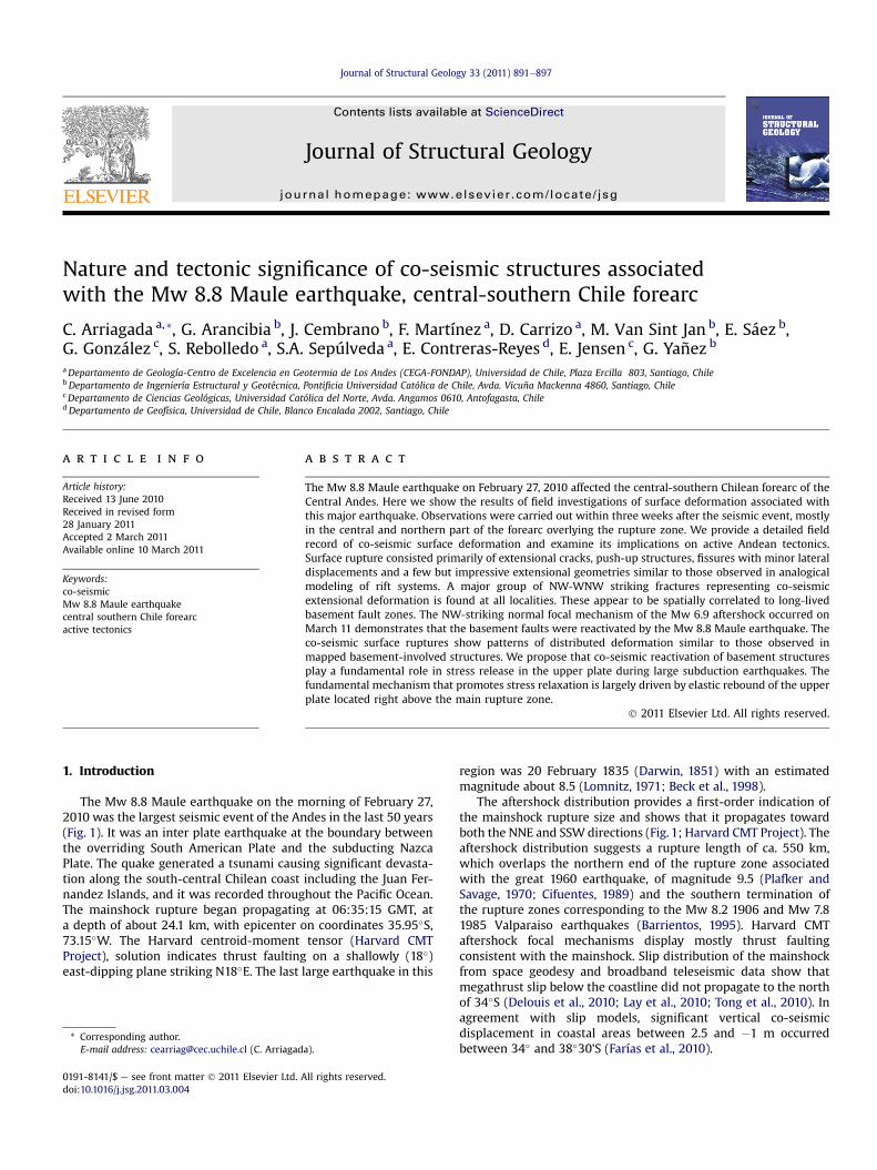
The Mw 8.8 Maule earthquake on the morning of February 27,2010 was the largest seismic event of the Andes in the last 50 years(Fig. 1). It was an inter plate earthquake at the boundary betweenthe overriding South American Plate and the subducting NazcaPlate. The quake generated a tsunami causing significant devasta-tion along the south-central Chilean coast including the Juan Fer-nandez Islands, and it was recorded throughout the Pacific Ocean.The mainshock rupture began propagating at 06:35:15 GMT, ata depth of about 24.1 km, with epicenter on coordinates 35.95�S,73.15�W. The Harvard centroid-moment tensor (Harvard CMTProject), solution indicates thrust faulting on a shallowly (18�)east-dipping plane striking N18�E. The last large earthquake in this
a).
ll rights reserved.
region was 20 February 1835 (Darwin, 1851) with an estimatedmagnitude about 8.5 (Lomnitz, 1971; Beck et al., 1998).
The aftershock distribution provides a first-order indication ofthe mainshock rupture size and shows that it propagates towardboth the NNE and SSW directions (Fig. 1; Harvard CMT Project). Theaftershock distribution suggests a rupture length of ca. 550 km,which overlaps the northern end of the rupture zone associatedwith the great 1960 earthquake, of magnitude 9.5 (Plafker andSavage, 1970; Cifuentes, 1989) and the southern termination ofthe rupture zones corresponding to the Mw 8.2 1906 and Mw 7.81985 Valparaiso earthquakes (Barrientos, 1995). Harvard CMTaftershock focal mechanisms display mostly thrust faultingconsistent with the mainshock. Slip distribution of the mainshockfrom space geodesy and broadband teleseismic data show thatmegathrust slip below the coastline did not propagate to the northof 34�S (Delouis et al., 2010; Lay et al., 2010; Tong et al., 2010). Inagreement with slip models, significant vertical co-seismicdisplacement in coastal areas between 2.5 and �1 m occurredbetween 34� and 38�30’S (Farías et al., 2010).
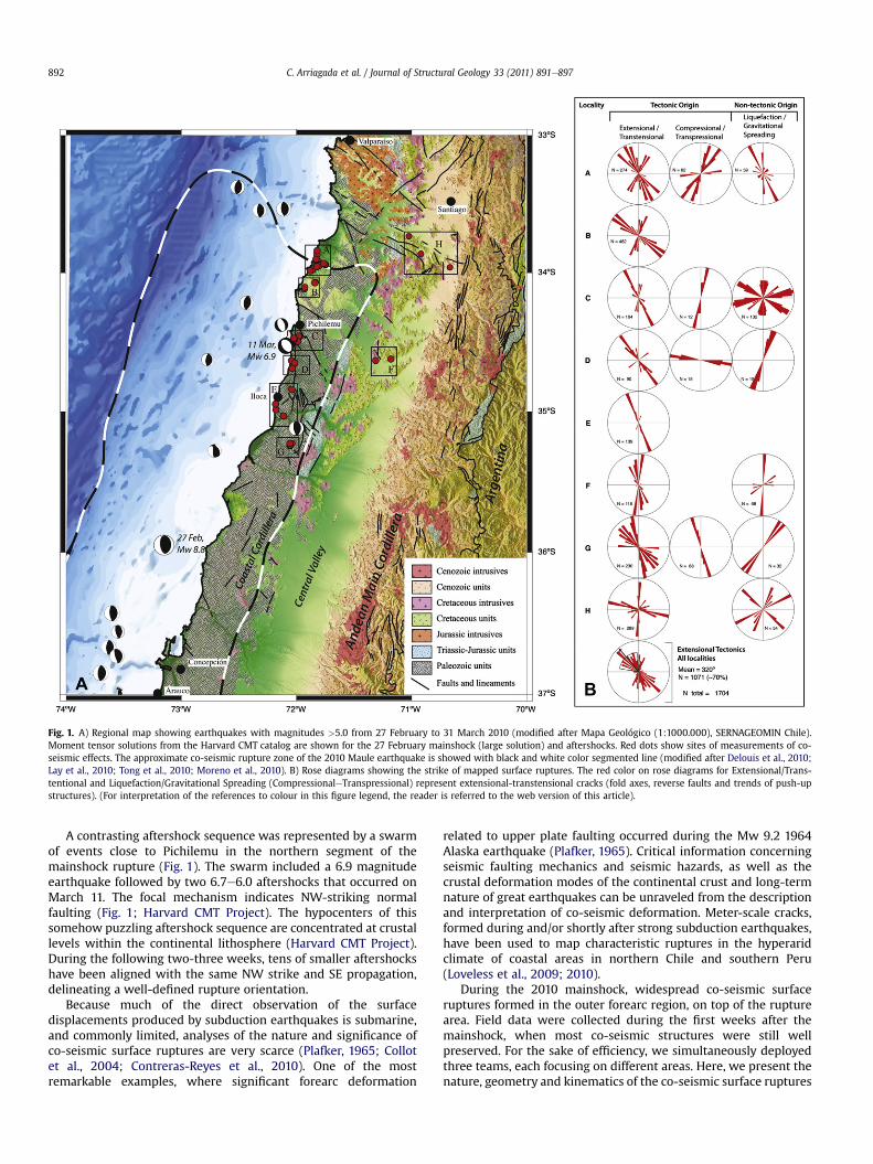
Fig. 1. A) Regional map showing earthquakes with magnitudes >5.0 from 27 February to 31 March 2010 (modified after Mapa Geológico (1:1000.000), SERNAGEOMIN Chile).Moment tensor solutions from the Harvard CMT catalog are shown for the 27 February mainshock (large solution) and aftershocks. Red dots show sites of measurements of co-seismic effects. The approximate co-seismic rupture zone of the 2010 Maule earthquake is showed with black and white color segmented line (modified after Delouis et al., 2010;Lay et al., 2010; Tong et al., 2010; Moreno et al., 2010). B) Rose diagrams showing the strike of mapped surface ruptures. The red color on rose diagrams for Extensional/Trans-tentional and Liquefaction/Gravitational Spreading (CompressionaleTranspressional) represent extensional-transtensional cracks (fold axes, reverse faults and trends of push-upstructures). (For interpretation of the references to colour in this figure legend, the reader is referred to the web version of this article).
C. Arriagada et al. / Journal of Structural Geology 33 (2011) 891e897892
A contrasting aftershock sequence was represented by a swarmof events close to Pichilemu in the northern segment of themainshock rupture (Fig. 1). The swarm included a 6.9 magnitudeearthquake followed by two 6.7e6.0 aftershocks that occurred onMarch 11. The focal mechanism indicates NW-striking normalfaulting (Fig. 1; Harvard CMT Project). The hypocenters of thissomehow puzzling aftershock sequence are concentrated at crustallevels within the continental lithosphere (Harvard CMT Project).During the following two-three weeks, tens of smaller aftershockshave been aligned with the same NW strike and SE propagation,delineating a well-defined rupture orientation.
Because much of the direct observation of the surfacedisplacements produced by subduction earthquakes is submarine,and commonly limited, analyses of the nature and significance ofco-seismic surface ruptures are very scarce (Plafker, 1965; Collotet al., 2004; Contreras-Reyes et al., 2010). One of the mostremarkable examples, where significant forearc deformation
related to upper plate faulting occurred during the Mw 9.2 1964Alaska earthquake (Plafker, 1965). Critical information concerningseismic faulting mechanics and seismic hazards, as well as thecrustal deformation modes of the continental crust and long-termnature of great earthquakes can be unraveled from the descriptionand interpretation of co-seismic deformation. Meter-scale cracks,formed during and/or shortly after strong subduction earthquakes,have been used to map characteristic ruptures in the hyperaridclimate of coastal areas in northern Chile and southern Peru(Loveless et al., 2009; 2010).
During the 2010 mainshock, widespread co-seismic surfaceruptures formed in the outer forearc region, on top of the rupturearea. Field data were collected during the first weeks after themainshock, when most co-seismic structures were still wellpreserved. For the sake of efficiency, we simultaneously deployedthree teams, each focusing on different areas. Here, we present thenature, geometry and kinematics of the co-seismic surface ruptures
C. Arriagada et al. / Journal of Structural Geology 33 (2011) 891e897 893
produced in the northern part of the area affected by themainshockwith the aim of provide insights into the effects of a largesubduction inter plate earthquake on the nature and extent ofsurface deformation. From this, in turn, we can better understandthe way by which stresses are transferred to the upper plate duringand after a large earthquake.
2. Tectonic setting
The Nazca-South American plate boundary runs for severalthousand km from the triple junction of the Nazca, South American,and Antarctic plates at 46�S latitude to northwestern SouthAmerica. Plate convergence takes place at ca. 70 mm/year in
Fig. 2. Representative photographs of co-seismic open cracks without significant vertical disto the surface images in order to map the main structural features; (b) Main structural featuand normal displacement in locality A. (c) Evidence for NE-SW right lateral and normal displSE extensional cracks with left-lateral displacement in locality A. (f) NW-SE extensional cra
a N78�E direction (Angermann et al., 1999). The Andean segmentcorresponding to the rupture area of the Mw 8.8 2010 earthquakeextends approximately from south of Valparaiso to the AraucoPenínsula (Fig. 1). In this segment, the Central Andes exhibitmodest Cenozoic shortening in comparison with the northernmostpart of this Cordillera (e.g. Ramos et al., 2004). Remarkably, thenorthern and southern ends of the rupture zone coincide very wellwith changes in trench orientation, suggesting long-term geologiccontrols of subduction earthquakes in the Andean margin (e.g.Allmendinger et al., 2010; Cembrano et al., 2010) (Fig. 1).
The main regional-scale structures of the Coastal Cordillerasegment are a series of WNW and NW-striking, subvertical faultzones that run across the continental margin (Fig. 1). The precise
placements. (a) During the field trip a stepladder was used to obtain nearly orthogonalres draped over a nearly orthogonal photograph showing co-seismic NE-SW left-lateralacement in locality A. (d) N 20�Wextensional cracks in locality A. (e) Evidence for NW-cks in locality D.
C. Arriagada et al. / Journal of Structural Geology 33 (2011) 891e897894
nature and timing of displacement along these fault zones is poorlyknown, although they have been interpreted as long-lived base-ment structures reactivated at different times, at least from theMesozoic (e.g. Wall et al., 1996; Yañez et al., 1998; Rivera andCembrano, 2000; Rivera and Yáñez, 2009). Recent studies suggestthat some of these faults may be active today and thus representseismic hazard (e.g. Sabaj et al., 2010).
3. Co-seismic, surface ruptures
We recognized co-seismic surface ruptures at 52 different sitesdistributed throughout the northern part of the area affected by themainshock (Fig. 1). We organized the sites into 8 localitiesaccording to their spatial distribution. Localities (AeE) are distrib-uted along the western edge of the Coastal Cordillera. Localities(FeG) are in the inner part of the Coastal Cordillera and locality (H)lies at the eastern edge of the Coastal Cordillera, immediately southof Santiago, Chile’s capital (Fig. 1).
During the field work we had the opportunity to interviewnumerous inhabitants of the region affected by the earthquake.According to information provided by residents, the observedruptures occurred during the mainshock. Furthermore, some of theauthors of this paper were mapping co-seismic surface ruptures inthe field close to the epicenter of the Mw 6.9 aftershock thatoccurred in March 11 at Pichilemu. There they could observe thatno new cracks formed during this aftershock and that previouslyformed cracks were not affected.
Field observations were conducted along road sections andaccessible footpaths, along and across the valleys. Direct observa-tion of the structures was conducted with the aid of a stepladder to
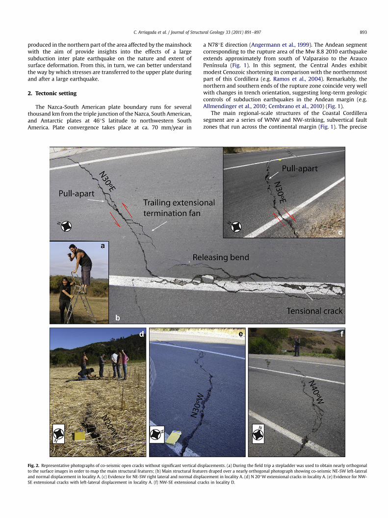
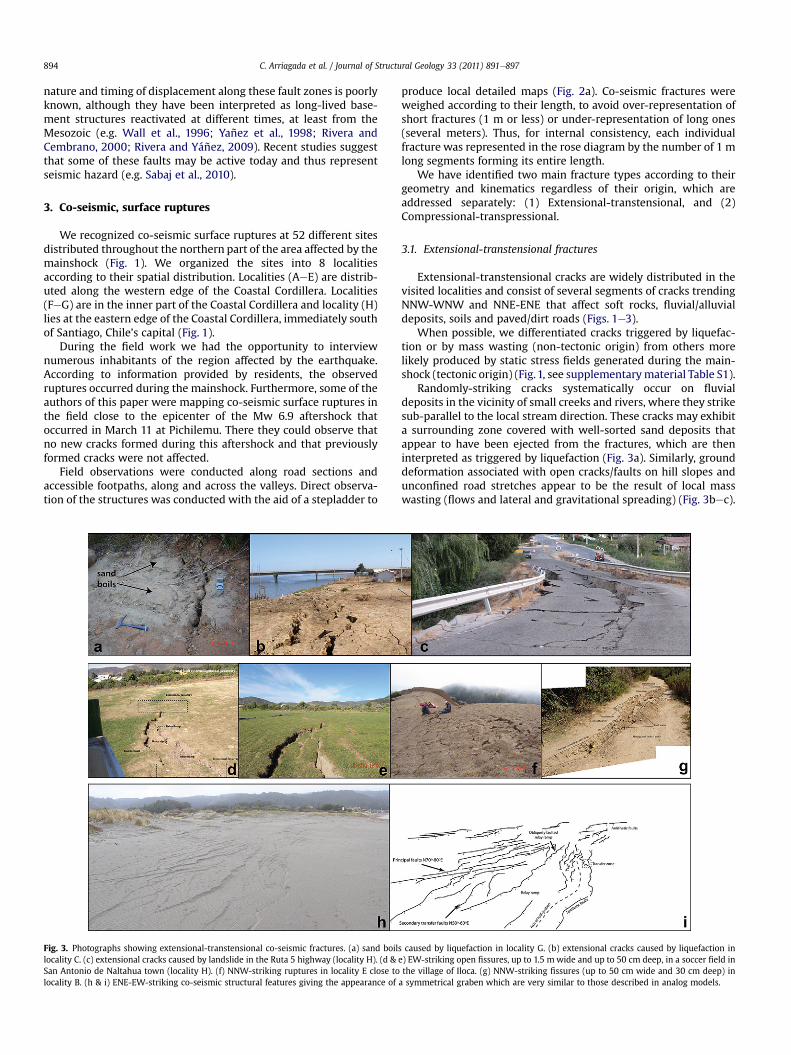
Fig. 3. Photographs showing extensional-transtensional co-seismic fractures. (a) sand boillocality C. (c) extensional cracks caused by landslide in the Ruta 5 highway (locality H). (d &San Antonio de Naltahua town (locality H). (f) NNW-striking ruptures in locality E close tolocality B. (h & i) ENE-EW-striking co-seismic structural features giving the appearance of
produce local detailed maps (Fig. 2a). Co-seismic fractures wereweighed according to their length, to avoid over-representation ofshort fractures (1 m or less) or under-representation of long ones(several meters). Thus, for internal consistency, each individualfracture was represented in the rose diagram by the number of 1 mlong segments forming its entire length.
We have identified two main fracture types according to theirgeometry and kinematics regardless of their origin, which areaddressed separately: (1) Extensional-transtensional, and (2)Compressional-transpressional.
3.1. Extensional-transtensional fractures
Extensional-transtensional cracks are widely distributed in thevisited localities and consist of several segments of cracks trendingNNW-WNW and NNE-ENE that affect soft rocks, fluvial/alluvialdeposits, soils and paved/dirt roads (Figs. 1e3).
When possible, we differentiated cracks triggered by liquefac-tion or by mass wasting (non-tectonic origin) from others morelikely produced by static stress fields generated during the main-shock (tectonic origin) (Fig.1, see supplementarymaterial Table S1).
Randomly-striking cracks systematically occur on fluvialdeposits in the vicinity of small creeks and rivers, where they strikesub-parallel to the local stream direction. These cracks may exhibita surrounding zone covered with well-sorted sand deposits thatappear to have been ejected from the fractures, which are theninterpreted as triggered by liquefaction (Fig. 3a). Similarly, grounddeformation associated with open cracks/faults on hill slopes andunconfined road stretches appear to be the result of local masswasting (flows and lateral and gravitational spreading) (Fig. 3bec).
s caused by liquefaction in locality G. (b) extensional cracks caused by liquefaction ine) EW-striking open fissures, up to 1.5 mwide and up to 50 cm deep, in a soccer field inthe village of Iloca. (g) NNW-striking fissures (up to 50 cm wide and 30 cm deep) ina symmetrical graben which are very similar to those described in analog models.
C. Arriagada et al. / Journal of Structural Geology 33 (2011) 891e897 895
Most of the surface ruptures which we interpret to representstress fields occur with consistent trends cross-cutting hill ridges,fluvial terraces and paved and unpaved roads (Figs. 2 and 3). Thesurface cracks are defined by numerous, adjacent segments ofinterlinked extensional and/or shear fractures (Figs. 2 and 3).Detailedmapping of the ruptures show that most of them are in therange of 10e100 m-long by 5e15 cm wide. Several centimeter-to-meter long segments making up the main cracks may locally showcurved shapes, zigezag patterns, step-overs and variable compo-nents of bulk sinistral and dextral horizontal separation (Fig. 2).Both left and right lateral strike- slip offset was observed at somelocations along the surface zone especially in paved roads, andrange from less than 1 cm to 3 cm (Fig. 2bef). Co-seismic, NW-striking surface ruptures were recognized in all localities andrepresent the most persistent orientation (w70%, Fig. 1). A minorproportion (w30%) of cracks strike NNE and NS.
The most prominent co-seismic fractures were observed inlocalities B, C, E and H (Fig. 3dei). A remarkable case occurred atlocality H. There, wEW-striking graben structures affect a soccerfield and several houses, and can be followed along-strike for morethan 5 km (Fig. 3e). This graben structure is probably tectonic inorigin because no evidence for liquefaction and/or gravitationalspreading was found (Supplementary material Figure S1).
Individual NNW-striking ruptures reach 60 m long on top ofa cliff east of Iloca (Fig. 3f), which can be interpreted as the result oftectonic extension while structures dip both in favor and againstthe local slope, ruling out a mass wasting origin.
At least 500 m-long surface ruptures occurred in locality C closeto the coast and parallel to the northern shore of a local lagoon.
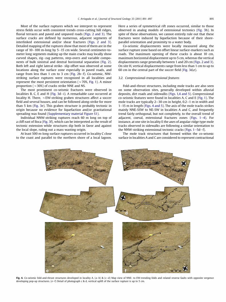
Fig. 4. Co-seismic fold-and-thrust structures developed in locality A. (aeb) & (ced) Map vdeveloping pop-up structures. (eef) Detail of photograph c & d, vertical uplift of the surfac
Here a series of symmetrical rift zones occurred, similar to thoseobserved in analog models of extensional tectonics (Fig. 3h). Inspite of these observations, we cannot entirely rule out that thesefractures were induced by liquefaction because of their shore-parallel orientation and proximity to a water body.
Co-seismic displacements were locally measured along thesurface rupture zone based on offset linear surface-markers such asroads. The maximum opening of these cracks is about 10 cm,maximumhorizontal displacement up to 5 cm, whereas the verticaldisplacements range generally between 1 and 20 cm (Figs. 2 and 3).On site H, vertical displacements range from less than 1 cm to up to60 cm in the central part of the soccer field (Fig. 3d,e).
3.2. Compressional-transpressional features
Fold-and-thrust structures, including mole tracks are also seenon some observation sites, generally developed within alluvialdeposits, dirt roads and sidewalks (Figs. 1,4 and 5). Compressionalco-seismic features were found in localities A, C and E (Fig. 1). Themole tracks are typically 2e30 cm in height, 0.2e1 m in width and1e15 m in length (Figs. 4 and 5). The axis of the mole tracks strikesmainly NNE-SSW to NE-SW in localities A and C, and frequentlytrend fairly orthogonal, but not completely, to the overall trend ofadjacent, coeval, extensional fractures zones (Figs. 1e4). Forinstance, at one site in locality E the axes of angular-ridge typemoletracks observed in sidewalks are following a similar orientation tothe NNW-striking extensional tectonic cracks (Figs. 1e5def).
The mole track structures that formed within the co-seismicsurface in localities A and C are considered to represent contractional
iew of NNE- to EW-trending folds and related reverse faults with opposite vergencee rupture is up to 5 cm.
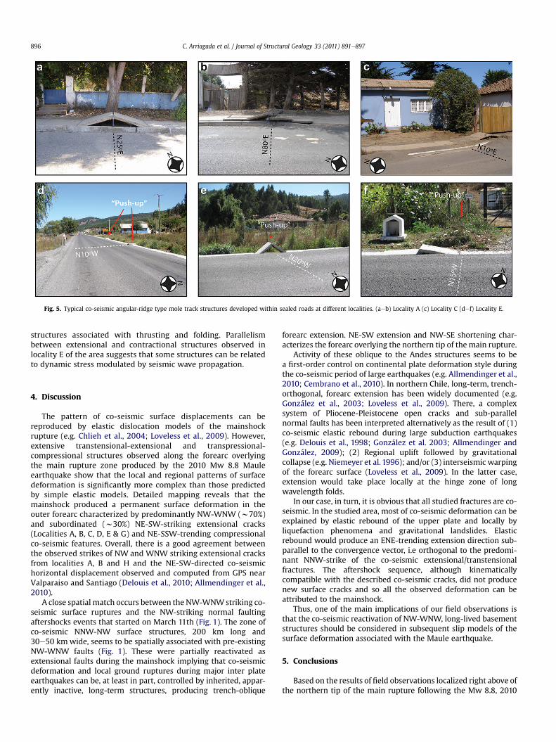
Fig. 5. Typical co-seismic angular-ridge type mole track structures developed within sealed roads at different localities. (aeb) Locality A (c) Locality C (def) Locality E.
C. Arriagada et al. / Journal of Structural Geology 33 (2011) 891e897896
structures associated with thrusting and folding. Parallelismbetween extensional and contractional structures observed inlocality E of the area suggests that some structures can be relatedto dynamic stress modulated by seismic wave propagation.
4. Discussion
The pattern of co-seismic surface displacements can bereproduced by elastic dislocation models of the mainshockrupture (e.g. Chlieh et al., 2004; Loveless et al., 2009). However,extensive transtensional-extensional and transpressional-compressional structures observed along the forearc overlyingthe main rupture zone produced by the 2010 Mw 8.8 Mauleearthquake show that the local and regional patterns of surfacedeformation is significantly more complex than those predictedby simple elastic models. Detailed mapping reveals that themainshock produced a permanent surface deformation in theouter forearc characterized by predominantly NW-WNW (w70%)and subordinated (w30%) NE-SW-striking extensional cracks(Localities A, B, C, D, E & G) and NE-SSW-trending compressionalco-seismic features. Overall, there is a good agreement betweenthe observed strikes of NW and WNW striking extensional cracksfrom localities A, B and H and the NE-SW-directed co-seismichorizontal displacement observed and computed from GPS nearValparaiso and Santiago (Delouis et al., 2010; Allmendinger et al.,2010).
A close spatial match occurs between the NW-WNWstriking co-seismic surface ruptures and the NW-striking normal faultingaftershocks events that started on March 11th (Fig. 1). The zone ofco-seismic NNW-NW surface structures, 200 km long and30e50 kmwide, seems to be spatially associated with pre-existingNW-WNW faults (Fig. 1). These were partially reactivated asextensional faults during the mainshock implying that co-seismicdeformation and local ground ruptures during major inter plateearthquakes can be, at least in part, controlled by inherited, appar-ently inactive, long-term structures, producing trench-oblique
forearc extension. NE-SW extension and NW-SE shortening char-acterizes the forearc overlying the northern tip of the main rupture.
Activity of these oblique to the Andes structures seems to bea first-order control on continental plate deformation style duringthe co-seismic period of large earthquakes (e.g. Allmendinger et al.,2010; Cembrano et al., 2010). In northern Chile, long-term, trench-orthogonal, forearc extension has been widely documented (e.g.González et al., 2003; Loveless et al., 2009). There, a complexsystem of Pliocene-Pleistocene open cracks and sub-parallelnormal faults has been interpreted alternatively as the result of (1)co-seismic elastic rebound during large subduction earthquakes(e.g. Delouis et al., 1998; González et al. 2003; Allmendinger andGonzález, 2009); (2) Regional uplift followed by gravitationalcollapse (e.g. Niemeyer et al. 1996); and/or (3) interseismic warpingof the forearc surface (Loveless et al., 2009). In the latter case,extension would take place locally at the hinge zone of longwavelength folds.
In our case, in turn, it is obvious that all studied fractures are co-seismic. In the studied area, most of co-seismic deformation can beexplained by elastic rebound of the upper plate and locally byliquefaction phenomena and gravitational landslides. Elasticrebound would produce an ENE-trending extension direction sub-parallel to the convergence vector, i.e orthogonal to the predomi-nant NNW-strike of the co-seismic extensional/transtensionalfractures. The aftershock sequence, although kinematicallycompatible with the described co-seismic cracks, did not producenew surface cracks and so all the observed deformation can beattributed to the mainshock.
Thus, one of the main implications of our field observations isthat the co-seismic reactivation of NW-WNW, long-lived basementstructures should be considered in subsequent slip models of thesurface deformation associated with the Maule earthquake.
5. Conclusions
Based on the results of field observations localized right above ofthe northern tip of the main rupture following the Mw 8.8, 2010
C. Arriagada et al. / Journal of Structural Geology 33 (2011) 891e897 897
Maule earthquake, we arrived at the following conclusionsregarding co-seismic surface deformation produced during theearthquake:
1. Co-seismic ruptures were widely developed and consistedprimarily of extensional cracks, push-up structures, fissureswith minor lateral displacements and a few but impressivegeometries similar to those observed in analogical modeling ofrift systems.
2. Most of co-seismic deformation can be explained by elasticrebound of the upper plate and locally by liquefactionphenomena and gravitational landslides.
3. NW-striking extensional co-seismic ruptures were recognizedin all localities, represent the most persistent orientation andseem to be spatially associated with pre-existing NW-WNWfaults that were partially reactivated as extensional faultsduring the mainshock.
4. Our results suggest that co-seismic deformation and localground ruptures during major inter plate earthquakes can be,at least in part, controlled by inherited, apparently inactive,long-lived structures.
5. Thus, long-lived basement structures should be considered insubsequent slip models of the surface deformation associatedwith the Maule earthquake.
Acknowledgements
We acknowledge support by the Engineering and GeotechnicalDepartment, Universidad Católica de Chile, the Departamento deGeología and Departamento de Geofísica at the Universidad deChile and the Departamento de Ciencias Geológicas de la Uni-versidad Católica del Norte. Discussions with Rick Allmendingerand Orlando Rivera are greatly appreciated. We thank editor CeesW. Passchier, Kate Clark and an anonymous referee for detailed,thoughtful reviews that improved the manuscript.
Appendix. Supplementary material
Supplementary data associated with this article can be found inthe online version, at doi:10.1016/j.jsg.2011.03.004.
References
Allmendinger, R.W., González, G., 2009. Neogene to Quaternary tectonics of the 237coastal Cordillera, northern Chile. Tectonophysics. doi:10.1016/j.tecto.2009.04.019.
Allmendinger, R.W., Yáñez, G., Cembrano, J., 2010. Interseismic strain, continentaldeformation, and great earthquakes of southern Chile. Abstract presented at theAGU Chapman Conference on Giant earthquakes and their tsunamis. Valparaíso,Chile.
Angermann, D., Klotz, J., Reigber, C., 1999. Space-geodetic estimation of the Nazca-South America Euler vector. Earth Planet. Sci. Lett. 171, 329e334.
Barrientos, S.E., 1995. Dual seismogenic behavior: the 1985 Central Chile earth-quake. Geophys. Res. Lett. 22, 3541e3544.
Beck, S., Barrientos, S., Kausel, E., Reyes, M., 1998. Source characteristics of historicearthquakes along the central Chile subduction zone. J. South. Am. Earth Sci. 11,115e129.
Cembrano, J., Yañez, G., Allmendinger, R.W., González, G., Rivera, O., Arancibia, G.,2010. Long-term geological controls on the nature and extension of earthquakerupture zones in the Chilean Andes: lessons from the 2010, Mw 8.8 MauleEarthquake. Gordon Conference on Rock Deformation, Tilton, NH, USA.
Chlieh, M., de Chabalier, J.B., Ruegg, J.C., Armijo, R., Dmowska, R., Campos, J.,Feigl, K.L., 2004. Crustal deformation and fault slip during the seismic cycle in
the North Chile subduction zone, from GPS and InSAR observations. Geophys. J.Int. 158, 695e711.
Cifuentes, I.L., 1989. The 1960 Chilean earthquake. J. Geophys. Res. 94, 665e680.Collot, J.-Y., Marcaillou, B., Sage, F., Michaud, F., Agudelo, W., Charvis, P.,
Graindorge, D., Gutscher, M.A., Spence, G.D., 2004. Are rupture zone limits ofgreat subduction earthquakes controlled by upper plate structures? Evidencefrom multichannel seismic reflection data acquired across the N-Ecuador-SWColombia margin. J. Geophys. Res. 109. doi:10.1029/2004JB003060.
Contreras-Reyes, E., Flueh, E.R., Grevemeyer, I., 2010. Tectonic control on sedimentaccretion and subduction of south central Chile: Implications for coseismicrupture processes of the 1960 and 2010 megathrust earthquakes. Tectonics 29,TC6018. doi:10.1029/2010TC002734.
Darwin, C., 1851. Geological Observations on Coral Reefs, Volcanic Islands and onSouth America. Smith, Elder and Co, Londres. 768p.
Delouis, B., Philip, H., Dorbath, L., Cisternas, A., 1998. Recent crustal deformation inthe Antofagasta region (northern Chile) and the subduction process. Geophys. J.Int. 132, 302e338.
Delouis, B., Nocquet, J.-M., Vallée, M., 2010. Slip distribution of the February 27, 2010Mw ¼ 8.8 Maule Earthquake, central Chile, from static and high-rate GPS,InSAR, and broadband teleseismic data. Geophys. Res. Lett. 37, L17305.doi:10.1029/2010GL043899.
Farías, M., Vargas, G., Tassara, A., Carretier, S., Baize, S., Melnick, D., Bataille, K., 2010.Land-Level changes produced by the Mw 8.8 2010 Chilean earthquake. Science329 (5994), 916. doi:10.1126/science.1192094.
González, G., Cembrano, J., Carrizo, D., Macci, A., Schneider, H., 2003. Link between262 forearc tectonics and Pliocene-Quaternary deformation of the coastalCordillera, northern Chile. J. South Am. Earth Sci. 18, 321e342.
Harvard CMT Project, see http://www.globalcmt.org/CMTsearch.html.Lay, T., Ammon, C.J., Kanamori, H., Koper, K.D., Sufri, O., Hutko, A.R., 2010. Tele-
seismic inversion for rupture process of the 27 February 2010 Chile (Mw 8.8)earthquake. Geophys. Res. Lett. 37, L13301. doi:10.1029/2010GL043379.
Lomnitz, C., 1971. Grandes terremotos y tsunamis en Chile durante el periodo1535e1955. Geofis. Panamericana 1, 151e178.
Loveless, J.P., Allmendinger, R., Pritchard, M., Garroway, J., González, G., 2009.Surface cracks record long-term seismic segmentation of the Andean margin.Geology 37, 23e26.
Loveless, J.P., Allmendinger, R.W., Pritchard, M.E., González, G., 2010. Normal andreverse faulting driven by the subduction zone earthquake cycle in thenorthern Chilean forearc. Tectonics 29, TC2001. doi:10.1029/2009TC002465http://www.agu.org/journals/ABS/2010/2009TC002465.shtml.
Moreno, M., Rosenau, M., Oncken, O., 2010. 2010 Maule earthquake slip correlateswith pre-seismic locking of Andean subduction zone. Nature 467, 198e202.doi:10.1038/nature09349.
Niemeyer, H., González, G., Martinez-De Los Rios, E., 1996. Evolución tectónicacenozoica del margen continental activo de Antofagasta, norte de Chile. RevistaGeológica de Chile 23, 165e186.
Plafker, G., 1965. Tectonic deformation associated with the 1964 Alaska earthquake.Science, v. 148, 1675e1687.
Plafker, G., Savage, J.C., 1970. Mechanism of the Chilean earthquake of may 21 and22 1960. Geol. Soc. Am. Bull. 81, 1001e1030.
Ramos, V., Zapara, T., Cristallini, E., Introcaso, A., 2004. The Andean thrust sys-temdlatitudinal variations in structural styles and orogenic shortening. In:McClay, K.R. (Ed.), Thrust Tectonics and Hydrocarbons Systems: AAPG Memoir82, 9, pp. 30e50.
Rivera, O.M. Cembrano, J. 2000. Modelo de formación de cuencas volcano-tectón-icas en zonas de transferencia oblicuas a la cadena andina: el caso de lascuencas Oligo-Miocenas de Chile Central y su relación con estructuras WNW-NW (33�00e34�30’S). In Congreso Geológico Chileno, No. 9, Actas, vol. 2, p.631e636. Puerto Varas.
Rivera, O., Yáñez, G., 2009. Naturaleza y Rol de Estructuras Translitosféricas en laEvolución del Arco Volcánico Oligo-Mioceno de Chile Central entre los 32� y 34�
S. In: XII Congreso Geológico Chileno. Simposio S9 Tectónica Y DeformaciónCortical Andina. Actas S9_092, Santiago, Chile. 5p.
Sabaj, R., Rebolledo, S., Leyton, F., Sepúlveda, S.A. 2010. Peligro sísmico asociado a lasfallas potencialmente activas en la cordillera de la costa entre los 33� y 33,45�S.In: X Congreso Chileno de Sismología e Ingeniería Antisísmica, Valdivia-San-tiago, Chile.
Tong, X., et al., 2010. The 2010 Maule, Chile earthquake: downdip rupture limitrevealed by space geodesy. Geophys. Res. Lett. 37, L24311. doi:10.1029/2010GL045805.
Wall, R., Gana, P., Gutiérrez, A. 1996. Mapa geológico del área de San Antonio-Melipilla, regiones de Valparaíso, Metropolitana y del Libertador General Ber-nardo O’Higgins. In: Servicio Nacional de Geología y Minería, Mapas Geológicos,No. 2, 20 p., 1 mapa 1:100.000. Santiago.
Yañez, G., Gana, P., Fernández, R., 1998. Sobre el orígen y significado geológico de laanomalía Melipilla, zona central de Chile. Revista Geológica de Chile 25 (2),175e198.