Embed Size (px)
Citation preview

Student Edition
Science Standard 4.2.b.
8 California Education and the Environment Initiative
Nature and Newcomers
History-Social Science Standard
5.8.4.
5

California Education and the Environment InitiativeApproved by the California State Board of Education, 2010
The Education and the Environment Initiative Curriculum is a cooperative endeavor of the following entities:California Environmental Protection Agency
California Natural Resources Agency
California State Board of Education
California Department of Education
Department of Resources Recycling and Recovery (CalRecycle)
Key Partners:Special thanks to Heal the Bay, sponsor of the EEI law, for their partnership
and participation in reviewing portions of the EEI curriculum.
Valuable assistance with maps, photos, videos and design was provided by the
National Geographic Society under a contract with the State of California.
Office of Education and the Environment1001 I Street • Sacramento, California 95814 • (916) 341-6769
http://www.CaliforniaEEI.org
© Copyright 2011 by the California Environmental Protection Agency© 2018 Third Edition
All rights reserved. This publication, or parts thereof, may not be used or reproduced without
permission from the Office of Education and the Environment.
These materials may be reproduced by teachers for educational purposes.

Lesson 1 “Ho! For California!”—From Wagon Trails to Highways
California Connections: A Route 66 Road Trip 2
Map of Overland Trails, Mountains, and Rivers 7
Lesson 2 Natural Systems Along the Trails
Diary Excerpts—Set 1 8
Diary Excerpts—Set 2 10
Diary Excerpts—Set 3 12
Lesson 3 Seasons and Reasons
Natural Regions Along the Overland Trails 14
Average Monthly Precipitation Data 15
Lesson 4 Life Cycles on the Prairie
None required for this lesson
Lesson 5 Choosing a Place to Call Home
Primary Source Guidebooks 16
Lesson 6 East to West: A Different Life
California and the Diary of Jane Gould Tourtillott 21
Contents

2 CALIFORNIA EDUCATION AND THE ENVIRONMENT INITIATIVE I Unit 5.8.4. I Nature and Newcomers I Student Edition
California Connections: A Route 66 Road Trip
Lesson 1 | page 1 of 5
Dear Mrs. Patten and Classmates:Dad and I are leaving tomorrow on a road trip. We are driving
to Chicago from Los Angeles in my grandfather’s Ford Woodie station wagon. He bought it in 1948. We will be going more than 2,000 miles, through eight states, on one road—the famous Route 66. US 66 was one of the first “highways” in the U.S. highway system.
Nowadays, people drive across the country on four-lane interstate highways. They travel between 65 and 75 miles per hour. Historic U.S. 66 is just a little, two-lane highway. It is cracked and bumpy in places. Most maps don’t even show this famous road anymore. Because of its important place in history, states have put up special signs to help people find Route 66.Route 66 follows many of the old historic trails. The old roads
were rough wagon roads that ran between the Midwest and the West Coast. The road followed the paths that American Indians used for hunting. As they traveled, native people walked from one river to the next. They searched for water and food. A man named William Becknell traveled these old trails in 1822. He led the first wagon train to Santa Fe, New Mexico, on the Santa Fe Trail.
Travelers from both Mexico and the United States used the Santa Fe Trail. They traveled in covered wagons, stagecoaches, or on horses and mules. People brought products to sell when they reached Santa Fe. The Santa Fe Trail and the Old Spanish Trail joined at Santa Fe so that people could travel from Chicago to Los Angeles and back.

CALIFORNIA EDUCATION AND THE ENVIRONMENT INITIATIVE I Unit 5.8.4. I Nature and Newcomers I Student Edition 3
California Connections: A Route 66 Road Trip
Lesson 1 | page 2 of 5
In 1921, Congress passed the Federal Aid Highway Act. The Act paid for the construction of a national system of roads. Route 66 connected the main streets of small towns and cities all the way from Chicago to Los Angeles. The road was mostly dirt or gravel when people first used it in 1926. It was not paved all the way to the West Coast until 1937. The famous author John Steinbeck called it the “Mother Road,” and some newspapers called it the “Main Street of America.”
Day 1—Santa Monica to BarstowWe start our trip at the Santa Monica Pier. It is foggy this
morning, but it looks like the Sun will shine by noon. Dad and I pull off our shoes and get our feet wet in the Pacific Ocean, for good luck. Gulls are all around us. They fly on winds that blow east. We will travel this direction on Route 66. Dad shows me some old postcards. One of them has a Ford Woodie in it, that looks just like our car.
Palm trees line the streets in Santa Monica. We drive down Ocean Avenue and say goodbye to the Pacific Ocean. Route 66 has different names as it passes through cities and towns. In some places, there are signs that tell us where to go. Sometimes we use our Route 66 guidebook. We drive through Beverly Hills on Santa Monica Boulevard. Then we drive through Hollywood and Los Angeles.
We come to the foot of the San Gabriel Mountains. This is where my dad grew up. He used to hike the fire roads above the city. Sometimes he saw hawks soaring overhead. At night, he would listen to the coyotes yip. Dad also told me that orange groves used to line Route 66 from Pasadena to San Bernardino. As California grew, towns and cities replaced the orchards.
We leave San Bernardino and begin to climb over Cajon Pass. We drive on the interstate highway when old Route 66 disappears. The pass is steep. Our old Woodie can only go one speed: slow!

4 CALIFORNIA EDUCATION AND THE ENVIRONMENT INITIATIVE I Unit 5.8.4. I Nature and Newcomers I Student Edition
California Connections: A Route 66 Road Trip
Lesson 1 | page 3 of 5
Wagon trains left Southern California on this same route during the second part of the 1800s. Travelers saw many bighorn sheep and deer as they rolled slowly up the grade. Today, few of these animals are left.
We pull off the interstate at a fire road. There are signs for Route 66 showing us where to go. The landscape has really changed since we left Santa Monica. There are piles of bluish-colored rock everywhere we look. This place is called Blue Cut. It is the point where Route 66 crosses the San Andreas Fault. A huge earthquake created Cajon Pass thousands of years ago when one side of the fault slid past the other. On the other side of Cajon Pass, we cross over the Mojave River. The Mojave River is an upside-down and backwards river. Instead of flowing on the surface, it mainly flows underground. Instead of flowing toward the ocean, it flows into the middle of the desert. In the past, travelers stopped to rest at the Mojave River. Then they continued their journey east to the Colorado River. On the other side of the river is the town of Victorville. We drive through Victorville, and on to Barstow. It is 102° F (39° C) in the desert! We will stay in Barstow tonight.
Day 2—Barstow to NeedlesIn the morning, we look out over the Mojave Desert. It
stretches as far as we can see. This “high” desert covers parts of California, Nevada, and Utah. Elevations range from 2,000 to 6,000 feet. We see Joshua trees along the horizon. They look like strange monsters waving their long arms in the air. Joshua trees are really a type of yucca plant. They don’t grow anywhere else in the world. The desert is so dry that each tree only grows a half-inch per year. Some of the tallest Joshua trees are at least 900 years old! It is strange to think that people traveling across the desert long ago saw the same trees we are looking at right now!

CALIFORNIA EDUCATION AND THE ENVIRONMENT INITIATIVE I Unit 5.8.4. I Nature and Newcomers I Student Edition 5
California Connections: A Route 66 Road Trip
Lesson 1 | page 4 of 5
We turn onto Interstate 40. It has replaced another part of Route 66. Most of the old road still runs close to the new highway. Today, we travel through some abandoned towns. Boards cover the windows, and some of the doors are wide open. We see a big tarantula crawling around an empty gas station!
Dad and I drive through Daggett and Newberry Springs. Dad tells me that Daggett used to be famous for its borax mines (borax is a mineral often used in detergents). Newberry Springs has a natural spring. The spring provided water for wagon trains between the Mojave and Colorado rivers.
Between Daggett and Amboy, Dad stops the car.“Look at that,” he says, pointing to what looks like a round rock
in the middle of the road.“What’s that?” I ask.“It is a desert tortoise. Did you know that desert tortoises are
an endangered species?”He tells me that the tortoise is a reptile. It stays underground
during the hottest times of the day and it sleeps through the winter. That tortoise better hurry, I think. It’s already getting hot!
Soon, we pass Amboy Crater. The last time this volcano erupted was 500 years ago. Bristol Dry Lake lies on the floor of this desert valley. It used to hold water long ago but now it holds salt that people have been mining for 100 years. Route 66 runs along it at the base of the foothills.
Dad and I end our second day in the town of Needles. We can see the beautiful Colorado River as we drive into town.
Day 3—Needles and Beyond…The Mojave Indians lived in this area for thousands of years.
They used water from the Colorado River to grow food. They made pottery with river clay. Later, settlers called this place “The Needles” after the sharp peaks at the end of the valley.

6 CALIFORNIA EDUCATION AND THE ENVIRONMENT INITIATIVE I Unit 5.8.4. I Nature and Newcomers I Student Edition
California Connections: A Route 66 Road Trip
Lesson 1 | page 5 of 5
The Colorado River used to flood Needles every spring until dams were built upstream. The river now sends part of its water to thirsty Southern California. Today, Dad and I will cross the Colorado River. We will head for Kingman, Arizona. In the next week, we will drive through seven more states on Route 66. Goodbye, California!
Your friend on the road,Dan Tucker
Lake Ontario
Lake Superior
La
ke
Mic
higa
n
Lake Erie
Lake Huron
Salt Lake
0 250 500 1,000
Miles
C A N A D A
M E X I C O
AT L A N T I C
O C E A N
PA C I F I C
O C E A N G U L F O F
M E X I C O
NEVADA
OREGON
COLORADO
NEBRASKA
MINNESOTA
IOWA
ARKANSAS
LOUISIANA
FLORIDA
MISSISSIPPI ALABAMAGEORGIA
TENNESSEE NORTH CAROLINA
WASHINGTON
SOUTHCAROLINA
WISCONSIN
INDIANA OHIOPENNSYLVANIA
NEW YORK
VIRGINIA
WESTVIRGINIA
MARYLAND
DELAWARE
NEW JERSEY
MAINE
CONNECTICUTRHODE ISLAND
MASSACHUSETTS
VERMONT
NEW HAMPSHIRE
KENTUCKY
MICHIGANWYOMING
MONTANA
IDAHO
NORTH DAKOTA
SOUTH DAKOTA
UTAH
CALIFORNIA
KANSAS
TEXAS
MISSOURI
ILLI NOIS
ARIZONANEW MEXICO
OKLAHOMA
Route 66Stops along Route 66
0 250 500 1,000
Miles
Route 66Stops along Route 66
Los Angeles
Barstow FlagstaffSanta Fe
AlbuquerqueTulsa
OklahomaCity
Amarillo
Chicago
SpringfieldSt. Louis

CALIFORNIA EDUCATION AND THE ENVIRONMENT INITIATIVE I Unit 5.8.4. I Nature and Newcomers I Student Edition 7
Map of Overland Trails, Mountains, and Rivers
Lesson 1
Tra
il R
ou
tes
O
rego
n Tr
ail
M
orm
on T
rail
C
alifo
rnia
Tra
il
San
ta F
e Tr
ail
012
525
050
0
Mile
s
Miss
issippi
M
issi
ss
ippi
Mis
souri
M
issouri
AT
LAN
TIC
O
CE
AN
PA
CIF
ICO
CE
AN
GU
LF O
FM
EX
ICO
Pla
tte
Hum
bo
ldt
Gre
at
Salt
Lake
Arkansas
Columbia
S
nake
S i e r r a N e v a d a
S i e r r a M a d r eR o c k y M o u n t a i n s
Sac
ram
ento
Ore
gon
City
Sal
t Lak
e C
ity
San
ta F
e
Inde
pend
ence
San
Fr
anci
sco
Fort
Sm
ith

8 CALIFORNIA EDUCATION AND THE ENVIRONMENT INITIATIVE I Unit 5.8.4. I Nature and Newcomers I Student Edition
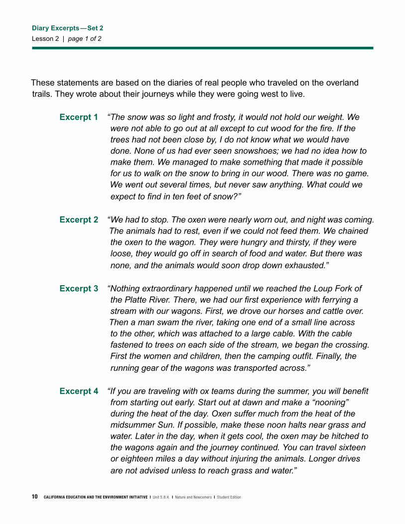
These statements are based on the diaries of real people who traveled on the overland trails. They wrote about their journeys while they were going west to live.
Excerpt 1 “Our journey from here to Soda Springs was harder. There were more mountains and fewer valleys. Ours were the first wagons to pass over this route. At times, we could pass along the mountainsides only by tying ropes to the top of our wagons. Men clung to the ropes to keep the wagons from tipping over. On the steepest slopes, men had to walk behind the wagons holding the ropes.”
Excerpt 2 “There were many animals around. We had seen a number of deer. One of our group members had killed a bear. So I had no fear of starvation. We were not far from California. I did not know much about the climate there. That night, three feet of snow fell. That was more snow than we expected. We had planned to go hunting the next day, but we could not. We were not worried. It was not very cold and we figured the snow would melt. But a week passed. More snow fell. At last, we had to kill our cows. They could not move through the deep snow to find food. Any grass they might have eaten was covered.”
Excerpt 3 “We drove our cattle six or eight miles this morning, then camped for the day. It was important to rest and graze our stock when we could. There was no vegetation on the hills and mountains around us except sage. Our cattle cannot graze on sage. We are sick of seeing only this plant.”
Excerpt 4 “Those living in the Southwest and heading for places south of San Francisco should travel the southern road running through Texas. This is the only practical road for comfortable winter travel. The grass along a great portion of this route is green during the entire winter. Snow seldom covers it.”
Diary Excerpts—Set 1
Lesson 2 | page 1 of 2

CALIFORNIA EDUCATION AND THE ENVIRONMENT INITIATIVE I Unit 5.8.4. I Nature and Newcomers I Student Edition 9
Diary Excerpts—Set 1
Lesson 2 | page 2 of 2
Excerpt 5 “Experienced travelers know where to look for water. One sure sign is deep green cottonwood or willow trees growing in low country. In addition, water rushes and tall green grass suggest water. Fresh tracks of animals moving to a common area will also lead to water. So will birds flying to a central area. If you see many deer, it is likely that water is not far. These animals drink daily and they will not stay in an area after the water has dried up.”
Excerpt 6 “The whole sky became black as ink. The rain came down in bucketfuls, drenching us to the skin. Not one tent in the camp held against the terrific wind. The men had to chain the wagons together to keep them from being blown into the river.”
10 CALIFORNIA EDUCATION AND THE ENVIRONMENT INITIATIVE I Unit 5.8.4. I Nature and Newcomers I Student Edition
Diary Excerpts—Set 2
Lesson 2 | page 1 of 2
These statements are based on the diaries of real people who traveled on the overland trails. They wrote about their journeys while they were going west to live.
Excerpt 1 “The snow was so light and frosty, it would not hold our weight. We were not able to go out at all except to cut wood for the fire. If the trees had not been close by, I do not know what we would have done. None of us had ever seen snowshoes; we had no idea how to make them. We managed to make something that made it possible for us to walk on the snow to bring in our wood. There was no game. We went out several times, but never saw anything. What could we expect to find in ten feet of snow?”
Excerpt 2 “We had to stop. The oxen were nearly worn out, and night was coming. The animals had to rest, even if we could not feed them. We chained the oxen to the wagon. They were hungry and thirsty, if they were loose, they would go off in search of food and water. But there was none, and the animals would soon drop down exhausted.”
Excerpt 3 “Nothing extraordinary happened until we reached the Loup Fork of the Platte River. There, we had our first experience with ferrying a stream with our wagons. First, we drove our horses and cattle over. Then a man swam the river, taking one end of a small line across to the other, which was attached to a large cable. With the cable fastened to trees on each side of the stream, we began the crossing. First the women and children, then the camping outfit. Finally, the running gear of the wagons was transported across.”
Excerpt 4 “If you are traveling with ox teams during the summer, you will benefit from starting out early. Start out at dawn and make a “nooning” during the heat of the day. Oxen suffer much from the heat of the midsummer Sun. If possible, make these noon halts near grass and water. Later in the day, when it gets cool, the oxen may be hitched to the wagons again and the journey continued. You can travel sixteen or eighteen miles a day without injuring the animals. Longer drives are not advised unless to reach grass and water.”

CALIFORNIA EDUCATION AND THE ENVIRONMENT INITIATIVE I Unit 5.8.4. I Nature and Newcomers I Student Edition 11
Diary Excerpts—Set 2
Lesson 2 | page 2 of 2
Excerpt 5 “The success of a long trip through open land depends mainly on the care taken of the animals. How they are driven, herded, and guarded is important. The great error that inexperienced travelers make is to overwork their cattle at the beginning of the trip. This causes more suffering and disaster than almost anything else does. There is plenty of grass and water in the eastern parts of the different routes. With proper care, animals should not give out before they reach the mountains. West of the mountains, water and grass are scarce. Animals must be in the best condition to endure that part of the journey.”
Excerpt 6 “We had 20 miles to go, and it was the hottest part of the day. At about two o’clock, we hit the heavy sand 10 miles from the Truckee River. It was very difficult moving our stock through. We had to stop every few yards to rest. A little before night, we reached the river. We all felt greatly relieved. We found abundant grass and fine water.”
12 CALIFORNIA EDUCATION AND THE ENVIRONMENT INITIATIVE I Unit 5.8.4. I Nature and Newcomers I Student Edition
Diary Excerpts—Set 3
Lesson 2 | page 1 of 2
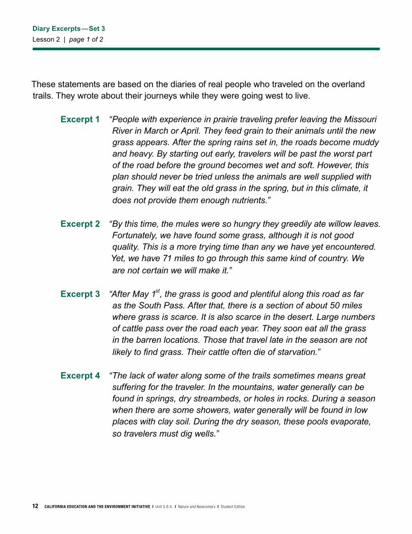
These statements are based on the diaries of real people who traveled on the overland trails. They wrote about their journeys while they were going west to live.
Excerpt 1 “People with experience in prairie traveling prefer leaving the Missouri River in March or April. They feed grain to their animals until the new grass appears. After the spring rains set in, the roads become muddy and heavy. By starting out early, travelers will be past the worst part of the road before the ground becomes wet and soft. However, this plan should never be tried unless the animals are well supplied with grain. They will eat the old grass in the spring, but in this climate, it does not provide them enough nutrients.”
Excerpt 2 “By this time, the mules were so hungry they greedily ate willow leaves. Fortunately, we have found some grass, although it is not good quality. This is a more trying time than any we have yet encountered. Yet, we have 71 miles to go through this same kind of country. We are not certain we will make it.”
Excerpt 3 “After May 1st, the grass is good and plentiful along this road as far as the South Pass. After that, there is a section of about 50 miles where grass is scarce. It is also scarce in the desert. Large numbers of cattle pass over the road each year. They soon eat all the grass in the barren locations. Those that travel late in the season are not likely to find grass. Their cattle often die of starvation.”
Excerpt 4 “The lack of water along some of the trails sometimes means great suffering for the traveler. In the mountains, water generally can be found in springs, dry streambeds, or holes in rocks. During a season when there are some showers, water generally will be found in low places with clay soil. During the dry season, these pools evaporate, so travelers must dig wells.”

CALIFORNIA EDUCATION AND THE ENVIRONMENT INITIATIVE I Unit 5.8.4. I Nature and Newcomers I Student Edition 13
Diary Excerpts—Set 3
Lesson 2 | page 2 of 2
Excerpt 5 “The wildest scenery we saw on the whole journey was while we were making our way through a range of hills. During this part of the trip, we had to follow a clear, pebble-paved stream called the Ratone. Sometimes, where the cliffs and drop-offs absolutely barred our way, we had to draw the wagons along in the creek bed. At one place, travel was so difficult that we advanced only a mile and a half in a day. We had to cut away overhanging branches and projecting roots. Heavy rocks had to be moved to make room for the wagons. The creek was barely wide enough for the wagons to fit between the rugged banks. One wagon was upset three times—once right into the creek.”
Excerpt 6 “Half up the mountain, we came to a steep wall of rock about ten feet high. There seemed to be no way through. We found a narrow break in the wall, wide enough for one ox to pass through. It was not wide enough for a wagon. We unhooked the oxen and led them through in single file. Then we used chains and hooked the oxen to one of the wagons ten feet below. With the oxen pulling from above and the men pushing from below, we slowly moved the first wagon up and over the wall of rock. In this way, we moved the wagons one by one over the steep rock.”

14 CALIFORNIA EDUCATION AND THE ENVIRONMENT INITIATIVE I Unit 5.8.4. I Nature and Newcomers I Student Edition
Natural Regions Along the Overland Trails
Lesson 3
San Joaqu
in
Sac
ram
ento
K
lam
ath
S
nak
e C
olor
ado
G
il a
Rio G
rand
e
Brazos
Ark
ansa
s
Miss
issippi
Mis
sissippi
Missou ri
M
issouri
Alabama
O
hio
Wabash
Savannah
T
enne
ssee
Columbia
Hudson
Potom
ac
Great Pee Dee
Chattahoochee
Sai
nt J
ohn
GR
EA
T
SA
LT L
AK
E
Am
eric
an
Sw
eetw
ate
r
N
. Pla
tte
S
. P
latt
e
LAK
ES
UP
ER
IOR
LAK
EM
ICH
IGA
N
LAK
EH
UR
ON
LAK
EE
RIE
LAK
EO
NTA
RIO
AT
LAN
TIC
O
CE
AN
PA
CIF
ICO
CE
AN
GU
LF O
FM
EX
ICO
R o c k y M o u n t a i n s
Bla
ck
Hil
lsC
ol u
mb
ia P
late
au
Coastal Range
S i e r r a N evad a
C
oa
sta
l P
l ain
s
Appala
chian M
ounta
ins
La
s V
eg
as
Va
lle
y
Cascades
Ce
ntr
al
Lo
wla
nd
s
G r e a t P l a i n s
S ie r r a M ad re
Nat
ura
l Reg
ion
s
Te
mpe
rate
fore
st (d
ecid
uous
)
Gra
ssla
nd/P
rarie
D
eser
t
Alp
ine/
Mou
ntai
n
Cha
parr
al
Taig
a
012
525
050
0
Mile
s
CALIFORNIA EDUCATION AND THE ENVIRONMENT INITIATIVE I Unit 5.8.4. I Nature and Newcomers I Student Edition 15
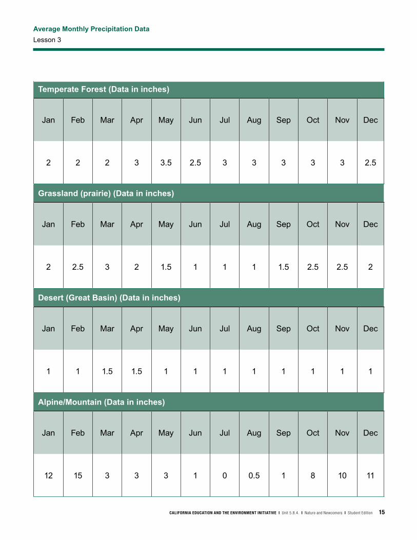
Average Monthly Precipitation Data
Lesson 3
Temperate Forest (Data in inches)
Jan Feb Mar Apr May Jun Jul Aug Sep Oct Nov Dec
2 2 2 3 3.5 2.5 3 3 3 3 3 2.5
Grassland (prairie) (Data in inches)
Jan Feb Mar Apr May Jun Jul Aug Sep Oct Nov Dec
2 2.5 3 2 1.5 1 1 1 1.5 2.5 2.5 2
Desert (Great Basin) (Data in inches)
Jan Feb Mar Apr May Jun Jul Aug Sep Oct Nov Dec
1 1 1.5 1.5 1 1 1 1 1 1 1 1
Alpine/Mountain (Data in inches)
Jan Feb Mar Apr May Jun Jul Aug Sep Oct Nov Dec
12 15 3 3 3 1 0 0.5 1 8 10 11

16 CALIFORNIA EDUCATION AND THE ENVIRONMENT INITIATIVE I Unit 5.8.4. I Nature and Newcomers I Student Edition
Primary Source Guidebooks
Lesson 5 | page 1 of 5
CALIFORNIA EDUCATION AND THE ENVIRONMENT INITIATIVE I Unit 5.8.4. I Nature and Newcomers I Student Edition 17
Primary Source Guidebooks
Lesson 5 | page 2 of 5
18 CALIFORNIA EDUCATION AND THE ENVIRONMENT INITIATIVE I Unit 5.8.4. I Nature and Newcomers I Student Edition
Primary Source Guidebooks
Lesson 5 | page 3 of 5

CALIFORNIA EDUCATION AND THE ENVIRONMENT INITIATIVE I Unit 5.8.4. I Nature and Newcomers I Student Edition 19
Primary Source Guidebooks
Lesson 5 | page 4 of 5
20 CALIFORNIA EDUCATION AND THE ENVIRONMENT INITIATIVE I Unit 5.8.4. I Nature and Newcomers I Student Edition
Primary Source Guidebooks
Lesson 5 | page 5 of 5
CALIFORNIA EDUCATION AND THE ENVIRONMENT INITIATIVE I Unit 5.8.4. I Nature and Newcomers I Student Edition 21
California and the Diary of Jane Gould Tourtillott
Lesson 6 | page 1 of 2
CaliforniaSettlers came to California for its land and raw materials. The area was rich with mountains, valleys, bays, rivers, lakes, marshes, beaches, and forests.
Farmland in the eastern United States was becoming less productive and more crowded. Therefore, many people came to California because the fertile soil and plentiful water made it a good place to farm. California's climate is also good for agriculture. Compared to the eastern United States, the winters are warmer and summers are cooler. Also, the region gets more sunny days and a long growing season with, for example, 220 clear days each year in the Sacramento area, many more than in states like New York. It also rains only half as often in San Francisco as in Portland, Maine, or St. Louis, Missouri. Agriculture was important to these migrants because most of them had been farmers.
California also had large amounts of raw materials for building towns and businesses. In the East, farmers had cleared much of the forest for farming. In California, there were untouched forests with a large supply of wood for building communities. Miners took gold, silver, and other minerals from the mountains where trappers collected furs. And, the rivers and ocean were full of fish. Westerners extracted and sold their raw materials to the industrial Northeast. Westerners sold timber, minerals, furs, and other natural resources to the industrial East, where businesses manufactured products that helped the economy grow.
The abundance of resources in the West attracted people and created economic opportunities that allowed settlers to further expand the United States.
22 CALIFORNIA EDUCATION AND THE ENVIRONMENT INITIATIVE I Unit 5.8.4. I Nature and Newcomers I Student Edition
California and the Diary of Jane Gould Tourtillott
Lesson 6 | page 2 of 2
The Diary of Jane Gould Tourtillott (Tohr-tee-yo)Sunday, September 21…
“There are houses and public wells all along on the road to Empire City, which is ten miles from Dayton. We stayed at Empire all night. This town is not as large as Dayton, but the streets are full of freight wagons. We see a great many fruit wagons here from California. There is a quartz mill here also. Money seems to be plenty. Buildings are going up fast. Here is the place to make money, a man without a family can get fifty dollars per month, and board, for most any kind of work, and mechanics get more.”
Wednesday, October 1… “Our roads are rather rough. I walked on before the teams two miles or more, then called at a farm for a drink and to rest. Had the pleasure of sitting in a large rocking chair, the first time in five months. They have plenty of fruit trees. Albert called for me and bought some fine grapes, and a pail of tomatoes. The lady of the house gave me some roses and verbenas, they were beautiful and fragrant too.”
Friday, October 3… “Arrived at the first house in the settlement in the San Joaquin Valley on this road at ten o’clock. The moon shone brightly, we pitched our tent and got supper. In this part of the country, all of the water is pumped by the power of windmills. The orchards are not as they are in the States, they are so small and the trees so near together. Every garden and orchard has its windmill to irrigate it.”
Wednesday, October 8… “Arose this morning with the intention of going to town. Lou and I went over a few minutes to call on Mrs. Burkett, she had a visitor from town, she regaled us with some very fine peaches. Went to town and pitched our tent. A lady called by the fence and told us of a house to rent, also gave us some green corn, the first we have had this year… Slept in a house for the first time for over five months… The house is very convenient. We pay ten dollars per month rent. The house is over half a mile from the business part of town.”


California Education and the Environment InitiativePrinted on post-consumer recycled paper584SE