Embed Size (px)
Citation preview
Adopted 17 December 2002
Natural Resources
Management Strategy
&Berrara Creekswan Lake

Adopted 17/12/02 File 12404
i Swan/Berrara Natural Resources Management Strategy
FOREWORD Why A Natural Resources Management Strategy? Swan Lake, Berrara Creek and their catchments are important community assets for environmental, economic, recreational and social reasons. Increasing demands for residential and recreational opportunities need to be balanced with protection of the very values of the area that people find attractive. We need to ensure the long-term protection of our environment, and to minimise our impacts on natural resources. To this end, Shoalhaven City Council, New South Wales and Commonwealth Government agencies, and the community have prepared this Natural Resources Management Strategy for Swan Lake, Berrara Creek and their catchments. It acknowledges past environmental management, attempts to integrate current programs and proposes some new approaches. We are doing this to safeguard the ecology of the waterways and their catchments, to balance potentially competing uses and to provide a framework for future planning. For more information on this project please contact: Natural Resources and Floodplain Unit Shoalhaven City Council Phone: 02 4429 3111 Fax: 02 4429 3175 Email: [email protected]
Project supported by:

Adopted 17/12/02 File 12404
ii Swan/Berrara Natural Resources Management Strategy
CONTENTS ABBREVIATIONS _____________________________________________iv
SUMMARY ___________________________________________________ v
1 INTRODUCTION ___________________________________________ 1 1.1 Swan Lake and Berrara Creek___________________________________ 1 1.2 Aim________________________________________________________ 1
1.2.1 NSW Coastal Policy _______________________________________ 1 1.2.2 Total Catchment Management _______________________________ 3 1.2.3 NSW Estuary Management Policy ____________________________ 3
1.3 Planning Process _____________________________________________ 3 1.4 Planning Framework __________________________________________ 4 1.5 Assistance __________________________________________________ 6 1.6 Consultation _________________________________________________ 6
2 The WATERWAYS AND THEIR CATCHMENTS__________________ 8 2.1 Location and Character ________________________________________ 8 2.2 Swan Lake _________________________________________________ 11 2.3 Berrara Creek ______________________________________________ 12 2.4 Groundwater _______________________________________________ 18 2.5 Geology and Soils ___________________________________________ 18 2.6 Vegetation _________________________________________________ 18 2.7 Animals ___________________________________________________ 19 2.8 Aboriginal Heritage __________________________________________ 20 2.9 European Heritage___________________________________________ 20 2.10 Resource Use_____________________________________________ 21
2.10.1 Waterways _____________________________________________ 21 2.10.2 Land __________________________________________________ 24
3 VALUES AND ISSUES _____________________________________ 28 3.1 Values - What’s Important About the Place ________________________ 28 3.2 Issues - Things That Might Detract From Values____________________ 28 3.3 Community Opinions _________________________________________ 28
4 MANAGEMENT PLAN _____________________________________ 32 4.1 Structure of Plan ____________________________________________ 32 4.2 Implementation _____________________________________________ 32 4.3 Funding Sources ____________________________________________ 32 4.4 Adaptive management - review _________________________________ 33
5 WATER QUALITY _________________________________________ 34 5.1 Values ____________________________________________________ 34 5.2 Objectives _________________________________________________ 34 5.3 Issues_____________________________________________________ 34 5.4 Strategies__________________________________________________ 40
6 EROSION AND SEDIMENTATION____________________________ 43 6.1 Values ____________________________________________________ 43 6.2 Objectives _________________________________________________ 43 6.3 Issues_____________________________________________________ 43 6.4 Strategies__________________________________________________ 44
7 NATURE CONSERVATION _________________________________ 46 7.1 Values ____________________________________________________ 46 7.2 Objectives _________________________________________________ 47 7.3 Issues_____________________________________________________ 47

Adopted 17/12/02 File 12404
iii Swan/Berrara Natural Resources Management Strategy
7.4 Strategies__________________________________________________ 48 8 ENTRANCE MANAGEMENT ________________________________ 52
8.1 Values ____________________________________________________ 52 8.2 Objectives _________________________________________________ 52 8.3 Issues_____________________________________________________ 52 8.4 Strategies__________________________________________________ 54
9 RECREATION ____________________________________________ 56 9.1 Values ____________________________________________________ 56 9.2 Objectives _________________________________________________ 56 9.3 Issues_____________________________________________________ 56 9.4 Strategies__________________________________________________ 57
10 VISUAL QUALITY _________________________________________ 62 10.1 Values __________________________________________________ 62 10.2 Objectives________________________________________________ 62 10.3 Issues ___________________________________________________ 62 10.4 Strategies ________________________________________________ 63
11 SELECT BIBLIOGRAPHY __________________________________ 64

Adopted 17/12/02 File 12404
iv Swan/Berrara Natural Resources Management Strategy
ABBREVIATIONS AHD Australian Height Datum (approx. mean sea level) ANZECC Australia New Zealand Environment and Conservation Council Bonn Convention
Convention on the Conservation of Migratory Species of Wild Animals
CAMBA China Australia Migratory Bird Agreement DLWC Department of Land and Water Conservation DMR Department of Mineral Resources EA Environment Australia EPA Environment Protection Authority JAMBA Japan Australia Migratory Bird Agreement LEP Local Environmental Plan L/s Litres per second NPWS National Parks and Wildlife Service NRMS Natural Resources Management Strategy ppt parts per thousand REP Regional Environmental Plan SCC Shoalhaven City Council SEPP State Environmental Planning Policy
Summary
Adopted 17/12/02 File 12404
v Swan/Berrara Natural Resources Management Strategy
SUMMARY This Swan Lake and Berrara Creek Natural Resources Management Strategy (NRMS) provides a comprehensive and integrated set of strategies to restore, protect and conserve the natural resources of the waterways and their catchments to ensure that their use is ecologically sustainable in the long term. The NRMS is the result of combining estuary management planning and catchment management planning into one process. The proposed strategies and actions in the NRMS deal with six management areas: water quality, erosion and sedimentation, nature conservation, entrance management, recreation and visual quality. For each management area the NRMS contains values, objectives, issues, strategies and actions. The strategies for each management area are set out in the tables below. The actions proposed for carrying out each strategy are set out in the tables in sections 5 through 10 of this document. The strategies and actions are of four types: planning and development controls, protective and remedial works, education programs and monitoring/research. The primary point of contact with the community during the preparation of this NRMS has been the Swan/Berrara Estuary Management Task Force. The task force has reviewed a number of drafts of the document and individual task force members have contributed greatly to its preparation. Extensive community consultation was undertaken to guide the preparation of the NRMS. In addition to informal discussions held with many people that have an interest in the area, the broader community has had formal opportunity to contribute through a comprehensive survey of community values and issues in February 2001. A draft version of the NRMS was exhibited for public comment from March to May 2002. The Swan/Berrara Estuary Management Task Force considered the submissions and discussed changes to the draft. Shoalhaven City Council adopted the NRMS in Decmber 2002.
Strategies for Water Quality WQ1 - Minimise sewage contamination of Swan Lake and Berrara Creek from
existing sewage management systems
WQ2 - Improve system for reuse and disposal of effluent from reticulated sewerage scheme
WQ3 - Control other pollutants at source
WQ4 - Minimise pollutant transport in stormwater drains
WQ5 - Ensure boating is not contaminating lake water
WQ6 – Monitor water quality
WQ7 - Educate residents and visitors on stormwater issues and solutions

Summary
Adopted 17/12/02 File 12404
vi Swan/Berrara Natural Resources Management Strategy
Strategies for Erosion and Sedimentation
ER1 - Accommodate natural processes of lake and creek bank erosion and accretion, but reduce human-induced erosion
ER2 - Reduce amount of sediment entering the creeks, lake and wetlands from the catchments by controlling erosion at its sources
Strategies for Nature Conservation
NC1 - Protect significant ecological communities and populations of rare or threatened species that are not in reserve system
NC2 - Retain the natural state of the Cudmirrah dunes
NC3 - Protect the natural values of foreshores and wetlands
NC4 - Educate visitors and residents on importance of protecting natural values
NC5 - Remove piles of garden waste from public areas
NC6 - Control weeds in bushland areas
NC7 - Protect lake and creek from introduction of Caulerpa taxifolia
NC8 - Maintain or establish buffer zones between developed areas and sensitive habitats, where possible
NC9 - Control populations of introduced animals in natural areas
NC10 - Reduce impact of roaming domestic animals on native animal populations
NC11 - Reduce impact of motor vehicle drivers on wildlife populations
Strategies for Entrance Management EM1 - Develop and adopt entrance management policy
EM2 – Minimise intervention in natural entrance behaviour, with full reinstatement in the longer term
EM3 - Adopt interim entrance management policy
EM4 - Prevent illegal opening of lake entrance
Strategies for Recreation R1 - Zone different parts of lake for appropriate uses (see figure 9-1)
R2 - Protect foreshores and public reserves from degradation due to recreational use
R3 - Provide access to public foreshore land next to Berrara Creek
R4 - Reduce impacts of motor vehicle drivers on recreational users of forest roads
Strategies for Visual Quality VQ1 - Maintain or restore visual character of natural landscapes and landforms
VQ2 - Ensure built forms do not impact adversely on coastal scenery

1. Introduction
Adopted 17/12/02 File 12404
1 Swan/Berrara Natural Resources Management Strategy
1 INTRODUCTION
1.1 SWAN LAKE AND BERRARA CREEK
Swan Lake and Berrara Creek are located in the City of Shoalhaven on the New South Wales south coast (see Figure 1-1). Swan Lake is a large brackish coastal lake that is intermittently connected to the sea. Berrara Creek is located about two kilometres south of Swan Lake and is much smaller. Most of the land surrounding the lake and creek is bushland, reserved as national park. There are three small villages beside the waterways. Swanhaven is located on the northeastern shore of Swan Lake and Cudmirrah is located beside the lake inlet. The village of Berrara is near the mouth of Berrara Creek. Swan Lake, Berrara Creek and their catchments are characterised by many environmental, social, commercial and recreational values that make them popular places for a wide variety of activities. However, the pressure of these uses has sometimes resulted in competition for and degradation of the area's natural resources.
1.2 AIM This Natural Resources Management Strategy provides a comprehensive and integrated set of strategies to restore, protect and conserve the natural resources of Swan Lake, Berrara Creek and their catchments so as to ensure that their use is ecologically sustainable in the long term. A number of government agencies, community groups and individuals have been involved in the management of the natural resources
of the Swan/Berrara area prior to the preparation of this NRMS. This NRMS aims to integrate existing programs and proposes some new approaches. The NRMS has been prepared under the following hierarchy of NSW Government policies. 1.2.1 NSW Coastal Policy The NSW Coastal Policy 1997 is the Government's policy for the co-ordinated planning and management of the NSW coastal zone. It aims to guide the management and planning of the coastal zone by co-ordinating the various policies, programs and standards which apply at both State and local government level including the Estuary Management Policy under which this Natural Resource Management Strategy has been developed. The 1997 Coastal Policy has as its central focus the ecologically sustainable development (ESD) of the NSW coastline, and is based on the four ESD principles contained in various NSW Acts and Statutes. These are: i). Conservation of biological
diversity and ecological integrity - the need to conserve the variety of all life forms, especially the variety of species, and to ensure that the productivity, stability and resilience of ecosystems is maintained.
ii). Intergenerational equity - that the present generation should ensure that the health, diversity and productivity of the environment is maintained or enhanced for the benefit of future generations.
iii). Improved valuation, pricing and incentive mechanisms - requires that environmental factors, such as the value of ecosystems, polluter pays principle etc be incorporated into the valuation of assets and services and considered in decision-making processes.
iv). The precautionary principle - that if there are threats of serious or irreversible environmental

1. Introduction
Adopted 17/12/02 File 12404
2 Swan/Berrara Natural Resources Management Strategy
# Shoalhaven River
#
Jervis Bay#
St Georges Basin
Nowra
Swan Lake
Berrara Creek
#
Sussex Inlet
Huskisson
Prin
ces
Hig
hway
#
Lake Conjola
Pacific OceanN
5 0 5 10 Kilometers
#
#
# Sydney#
Canberra
Swan Lake&
Berrara Creek
Figure 1-1. Location of Swan Lake and Berrara Creek.
kilometres

1. Introduction
Adopted 17/12/02 File 12404
3 Swan/Berrara Natural Resources Management Strategy
damage, lack of full scientific certainty should not be used as a reason for postponing measures to prevent environmental degradation.
1.2.2 Total Catchment
Management Total Catchment Management (TCM) is the overlying management approach that involves the coordinated use and management of land, water, vegetation, ecosystems and other resources within a drainage basin. In the Shoalhaven, the Southern Catchment Management Board manages TCM. In 2002, the Board released a draft blueprint for the management of natural resources in the region. 1.2.3 NSW Estuary Management
Policy The NSW Estuary Management Policy is one of several component policies under the umbrella NSW State Rivers and Estuaries Policy. The Estuary Management Policy has been developed by the State Government in recognition of the ecological, social and economic importance of the State's estuaries and in response to concern about the long-term consequences of their accelerating degradation. This policy forms part of a suite of catchment management policies and ‘provides for the assessment of all estuarine uses, the resolution of conflicts and the production of a unified and sustainable management plan for each estuary, including remedial works and the redirection of activities, where appropriate’ (NSW Government 1992). The goal of the Government’s Estuary Management Policy is to achieve integrated, balanced, responsible and ecologically sustainable use of the State’s estuaries, which form a key component of coastal catchments.
The Coastline Management Manual and Estuary Management Manual are currently being reviewed and combined into a single updated manual, which will reflect the principles of the NSW Coastal Policy and incorporate broad-based natural resource management principles.
1.3 PLANNING PROCESS A Management Team consisting of SCC and DLWC has overseen the preparation of the NRMS. A project officer prepared the NRMS, working with the community in doing so. The primary point of contact with the community has been the Swan/Berrara Estuary Management Task Force. The project officer was employed by Shoalhaven City Council on behalf of the Management Team. This NRMS is the result of combining catchment management planning and estuary management planning into one process. This approach to natural resource management is based on the following: • the quality of estuaries is largely
determined by the management of their catchments;
• one of the goals of catchment management is to work with local communities in developing a concise statement of major issues and preferred management for each of the major land and water units (catchments) in the area;
• it is the policy of government to integrate the management of natural resources;
• the approach will increase community understanding about how activities in the catchment impact the estuary;
• it will increase community input to planning;
• the strategies will identify landcare needs in the catchment.
Shoalhaven City Council has
1. Introduction
Adopted 17/12/02 File 12404
4 Swan/Berrara Natural Resources Management Strategy
management responsibility for a relatively large number of estuaries. Although considerable resources are put towards estuary management in the Shoalhaven, there had been concern in the community that, because of the high costs and length of time associated with the preparation and implementation of Estuary Management Plans for some of the City’s waterways, it would be a very long time before funds could made available for Swan Lake and Berrara Creek (and a number of other waterways). Nevertheless, there were immediate and ongoing management needs for these waterways, which could be better dealt with by a strategic rather than ad hoc approach. Consequently, the then Lower Shoalhaven Catchment Management Committee coordinated the getting of limited funding (see section 1.5) to employ a project officer to assist in the preparation of this NRMS. In preparing this NRMS, because of the limited funds available, it was not possible to complete all the steps for estuary management planning as set out the NSW Government’s Estuary Management Manual. In particular, the relatively expensive “Processes Study” was not done. Instead, the NRMS responds to immediate and foreseeable management needs, based on existing information. The NRMS includes actions for collection of new information where necessary and allows for improvement to future management based on that new information.
1.4 PLANNING FRAMEWORK There were a range of policies, plans and strategies that were considered during the preparation of this NRMS. These included: • NSW State Rivers and Estuaries
Policy • NSW Wetlands Management Policy • NSW Coastal Policy 1997
• NSW Government’s Water Quality and River Flow Interim Environmental Objectives
• Crown Land Foreshore Tenures Policy (non commercial occupations) (1991)
• Crown Lands Caravan Parks Policy.
At the same time as this NRMS was being prepared, the Healthy Rivers Commission was conducting an independent inquiry into management of coastal lakes in New South Wales (Healthy Rivers Commission, 2001). The content of discussion papers produced by the commission was considered when the strategies and actions in this NRMS were being developed. The Healthy Rivers Commission issued its final report on coastal lakes in April 2002, but the formal NSW Government response was still being formulated when this Swan Lake and Berrara Creek NRMS was finalised. The final Healthy Rivers Commission report retains the "Significant Protection" category for future management of Swan Lake, and indicates that coastal lakes in the Shoalhaven are priority areas for development of sustainability assessment and management plans. Shoalhaven City Council supports pilot assessments being undertaken for its coastal lakes, including Swan Lake. Whilst this NRMS was in preparation the NSW Government announced a 'Coastal Protection Package' that included, amongst other things, a Comprehensive Coastal Assessment (CCA) to be undertaken over three years. A Planning NSW fact sheet states that: "The environmental, social and economic values of the State’s 1300 km coastline will be assessed. The CCA will provide common data on, and an analysis of, the values of land within the coastal zone for use in planning and management decisions. This will involve standardising and

1. Introduction
Adopted 17/12/02 File 12404
5 Swan/Berrara Natural Resources Management Strategy
integrating existing data sets and the identification and filling of significant data/information gaps. The CCA will give State and Local Government, industry and the community high quality information to make decisions about coastal development and conservation. It will also provide information to guide investment decisions by coastal industries." It is not clear at this stage whether the CCA will provide any new information that would benefit the content of this Swan Lake and Berrara Creek Natural Resources Management Strategy. If it does, there will be opportunity to incorporate it during future reviews of this NRMS. The NSW National Parks and Wildlife Service is preparing a draft plan of management for the Conjola National Park which covers a large area of the catchments. The planning process for the national park is subject to the provisions of the National Parks and Wildlife Act 1974 and will involve input from the community. To provide for some consistency of planning for the area, the National Parks and Wildlife Service has participated in the preparation of this Natural Resources Management Strategy. Some of the strategies in this NRMS, for example proposals for education programs, may benefit from coordination on a regional basis. As this NRMS is implemented, there will be consideration of estuary management plans and other natural resources management strategies that have been adopted by Shoalhaven City Council (St Georges Basin, Lake Conjola, Currarong, Lake Wollumboola, Lake Tabourie and Ulladulla Harbour) and those currently in preparation (Narrawallee Inlet, Burrill Lake and Shoalhaven River). Some of the strategies in this NRMS may require amendments to existing Council planning and development controls (eg the LEP and Council
policies). Others affect the granting of development consents, permits and/or licences for works to repair existing degradation (eg bank stabilisation works) and to prevent future damage (eg sediment traps, artificial wetlands). Where possible, any plans to be amended or created have been identified in the actions for each strategy. Shoalhaven City Council has adopted a development control plan for foreshores. Development Control Plan No 62 (Foreshore Development Guidelines) provides detailed guidelines to ensure that development within foreshore areas is undertaken in a manner, which preserves the amenity of the foreshore, and is sympathetic to the physical constraints encountered within such areas. The DCP provides controls on, amongst other things, the height and bulk of foreshore development. Actions carried out as a result of this NRMS will have to comply with such legislation as: • Local Government Act 1993 (SCC) • Environmental Planning and
Assessment Act 1979 (planningNSW)
• State Environmental Planning Policy No. 14 - Coastal Wetlands (planningNSW)
• State Environmental Planning Policy No. 35 - Maintenance Dredging of Tidal Waterways (planningNSW)
• Local Environmental Plan 1985, (SCC)
• Crown Lands Act 1989 (DLWC) • Rivers and Foreshores
Improvement Act 1948 (DLWC) • Soil Conservation Act 1938 (DLWC) • Coastal Protection Act 1979
(DLWC) • Maritime Services Act 1935
(Waterways Authority) • Fisheries Management Act 1994
(NSW Fisheries)

1. Introduction
Adopted 17/12/02 File 12404
6 Swan/Berrara Natural Resources Management Strategy
• Protection of the Environment Operations Act 1997 (EPA)
• Native Vegetation Conservation Act 1997 (DLWC)
• National Parks and Wildlife Act 1974 (NPWS)
• Threatened Species Conservation Act 1995 (NPWS)
• Water Management Act 2000 (DLWC)
• Commonwealth Environment Protection and Biodiversity Conservation Act 1999(EA).
The information in the NRMS will also be used by Council to develop its annual State of the Environment report and its Strategic Business Plan which forms part of its internal Management Plan required by the Local Government Act.
1.5 ASSISTANCE Shoalhaven City Council and the Commonwealth Government (Natural Heritage Trust, National Landcare Program and Coasts and Clean Seas Initiative) provided financial assistance for the preparation of this NRMS. In addition, technical assistance has been provided by: • Department of Land and Water
Conservation • Southern Catchment Management
Board • Environment Protection Authority • Waterways Authority • NSW Fisheries • National Parks and Wildlife Service • planningNSW • Environment Australia • National Oceans Office • University of Wollongong.
1.6 CONSULTATION The Swan/Berrara Estuary Management Task Force was established in 1996 as an advisory committee to Shoalhaven City Council.
It provides a forum for resolving conflicting demands on Swan Lake and Berrara Creek and formulates long term management strategies to ensure their use is ecologically sustainable. Committee members are drawn from the local community, together with Council and State Government representatives. The Task Force was established to perform the role of an Estuary Management Committee in accordance with the Estuary Management Policy, but its role broadened to include management of natural resources in the catchment as well. Task force members have contributed greatly to the preparation of this NRMS. In addition to informal discussions held with many other people that have an interest in Swan Lake and Berrara Creek, the broader community has had a number of formal opportunities to contribute to the preparation of this NRMS. A questionnaire was distributed to gauge the Swan/Berrara community's opinions on a set of draft values and issues. Approximately one thousand three hundred papers were distributed in February 2001 by the following means: • letterbox drop at Cudmirrah,
Swanhaven, Berrara and surrounding rural areas
• mail to all ratepayers with a postal address outside the catchments
• delivery to five caravan parks in the catchments
• mail to others that have expressed an interest in natural resource management of the area, including private citizens, non-government organisations, Federal and State agencies, local politicians, all councillors and many council staff.
Two hundred and forty three responses were received by the end of

1. Introduction
Adopted 17/12/02 File 12404
7 Swan/Berrara Natural Resources Management Strategy
March 2001. Results are summarised in Section 3 of this NRMS. A draft NRMS was exhibited for public comment from March to May 2002. More than 330 written submissions were received. Following this exhibition of the draft NRMS, submissions were assessed, changes to the draft NRMS discussed by the task force and a final NRMS was adopted by Council in December 2002.

2. The Waterways and Their Catchments
Adopted 17/12/02 File 12404
8 Swan/Berrara Natural Resources Management Strategy
2 THE WATERWAYS AND THEIR CATCHMENTS
2.1 LOCATION AND CHARACTER Swan Lake and Berrara Creek are located just south of St Georges Basin and Jervis Bay in the City of Shoalhaven on the New South Wales south coast. By road they are approximately two hundred and ten kilometres south of Sydney and fifty kilometres south of Nowra. The waterways and their catchments are shown in Figure 2-1. Figure 2-2 shows geographical features around the waterways. The estuarine parts of these waterways are places where marine and terrestrial processes interact to produce particularly sensitive and complex coastal environments. These estuaries, along with others in New South Wales, have a common origin. They formed around four to six thousand years ago when sea level rose to its present position, drowning coastal river valleys. This sea level rise also triggered shoreward transport of huge volumes of sand that accumulated as beaches, many of which blocked off bays and river mouths. In the long term, the estuaries also have a common destiny. They are very large sediment traps - to be filled with sediment delivered from the surrounding catchments and from the sea. The time it takes to reach a mature stage depends primarily on catchment characteristics (water and sediment discharge), together with the initial dimensions and configuration of the estuarine basin.
The present day patterns of water and sediment dynamics that we see at Swan Lake and Berrara Creek can be explained in terms of the relative importance of catchment inputs, tidal forces and wave climate. The interaction of these forces also determines prevailing entrance conditions - a crucial factor in explaining the characteristics of a particular estuary. Swan Lake and Berrara Creek are naturally dynamic places, ie they change from time to time. These changes operate at various time scales, some over hours, days, weeks or years and others over decades, centuries or millennia. Some changes are cyclical and reasonably regular, such as the tidal rise and fall in Berrara Creek. Others may be cyclical but irregular, such as the rise and fall of water level in Swan Lake in response to rainfall, evaporation and the entrance opening or closing. Still other changes may be more permanent such as the shallowing of the lake from deposition of sediment. The time frames over which these changes operate may be much longer than the time that we have been associated with the lake. This sometimes leads to claims by people that the lake had 'never been so high for so long' or 'never closed for so long' or 'never opened so frequently' or 'never had so many birds on it' or 'never had so few fish in it' etc. What is meant here is that those people have not seen the lake in such a condition. Even people with relatively long associations with the area (forty years or more) are unlikely to have seen the full range of conditions that Swan Lake has experienced in its approximately 4,000 year existence. To expect that Swan Lake will always behave tomorrow the way it behaved yesterday is unrealistic.

2. T
he W
ater
way
s an
d Th
eir C
atch
men
ts
2. T
he W
ater
way
s an
d Th
eir C
atch
men
ts
9 Sw
an/B
erra
ra N
atur
al R
esou
rces
Man
agem
ent S
trate
gy
#
Cud
mirr
ah#
Berra
ra
Berr
ara
Cre
ekca
tchm
ent
Swan
Lak
eca
tchm
ent
Princes Highway
Suss
ex In
let R
oad
#
Swan
have
n
Suss
exIn
let
St G
eorg
esBa
sin
32 s
quar
eki
lom
etre
s
37 s
quar
eki
lom
etre
s
10
12
3Ki
lom
eter
s
N
Fi
gure
2-1
. Sw
an L
ake
and
Berra
ra C
reek
wat
er c
atch
men
ts
kilo
met
res

2. The Waterways and Their Catchments
2. The Waterways and Their Catchments 10 Swan/Berrara Natural Resources Management Strategy
Figure 2-2 Geographical features around Swan Lake and Berrara Creek Source: © LAND AND PROPERTY INFORMATION PANORAMA AVENUE BATHURST 2795 www.lpi.nsw.gov.au
2. The Waterways and Their Catchments
Adopted 17/12/02 File 12404
11 Swan/Berrara Natural Resources Management Strategy
2.2 SWAN LAKE Swan Lake is a large brackish coastal lake that is intermittently connected to the sea. It has a surface area of about 4.5 to 5 square kilometres and consists of a broad, shallow basin and a narrow, sinuous inlet about a kilometre long that occasionally opens to the sea. In the deepest part of the lake (see figure 2-3), the bed is about 3.8 metres below AHD (see page iv). The actual water depth at that point varies as the lake rises and falls and would be over 6 metres when the lake rises to its maximum height before opening to the sea (about 2.5 metres above AHD). In the Healthy Rivers Commission (2001) inquiry into coastal lakes, Swan Lake was identified as having high sensitivity and high conservation value. The Commission proposed that the lake be classified in the ‘Significant Protection’ category for future management. The catchment of the lake is about 32 square kilometres of mostly forested land. Two streams, Mondayong Creek and Teatree Creek drain into the north west of the lake basin. These creeks are brackish for about one kilometre upstream of where they join the lake. Otherwise, only minor drainage lines exist around the lake. A bedrock outcrop (reef) to the south confines the entrance. To the north, dunes behind Cudmirrah Beach form a sand barrier, which extends southward as a spit to the lake inlet. A low point is present in the dune at a point where a meander in the inlet comes close to the back of the dune. This is known locally as ‘The Gap’ and there has been much debate about whether or not the lake has, in the past, connected to the sea at this point, or whether it should be artificially opened there in the future. It may be that some claims that timber-carrying
barges passed through The Gap early this century result from confusion with another waterway with the same name near Sussex Inlet, a few kilometres to the north. Swan Lake is a naturally variable place. Swan Lake is typical of many south coast lagoons in that it is usually closed to the sea by a sand bar and the condition of the lake's entrance plays an important part in the state of the estuarine ecosystem. The biological, chemical and physical character of the lake may stay relatively stable for months or years and then change dramatically within a short period if the entrance opens. The lake then functions as a tidal waterway for some time. The condition of the lake’s entrance is controlled by tides, waves, currents, sediment movement, creek flows, floods and human intervention. The interaction and ever changing nature of these factors may cause the entrance to migrate along the coastline, to close up, re-open, etc. At best, an ever-restless dynamic equilibrium exists that may be punctuated by irregular and sudden changes of behaviour (NSW Government, 1992). To protect the high natural values of the lake, including maintenance of natural fluctuations in their ecological conditions and biodiversity, water quality and habitat, it is necessary to achieve as close to a natural opening regime as possible, ie, the lakes' water levels and connections to the sea should be allowed to vary naturally. The ecology of the lake is profoundly affected by the behaviour of the connection to the sea. When the lake drains there are great changes not only to the water level and volume, but also to the chemical and physical qualities of the water. Pollard (1994a) measured salinity and temperature in Swan Lake from 1984 to 1988.

2. The Waterways and Their Catchments
Adopted 17/12/02 File 12404
12 Swan/Berrara Natural Resources Management Strategy
Salinity of around 10 ppt (sea water is about 36 ppt) at the beginning of the sampling period was gradually reduced, due to freshwater inflow, to around 6 ppt a year later. When the lake opened to the sea, salinity gradually rose to about 16 ppt. Temperature varied from about 10°C in winter to about 25°C in summer. Some kinds of fish and shellfish that live in the lakes breed in the oceanic or coastal waters and enter the lakes as larvae or juveniles. Therefore, the behaviour of the lake's entrances, in conjunction with many other factors, can affect the numbers of fish of different ages that are present in the lake at any point in time. However, because of the complexities of the processes involved and our lack of understanding of these processes, it is extremely difficult, if not impossible to artificially manipulate the entrance opening with any certainty of enhancing fish or prawn production in the lakes. Artificial opening of the lakes may have negative impacts on fisheries production. Occasionally, if water levels remain high for extended periods of time, then some die-back of terrestrial vegetation around the edges of the lake will occur. Likewise, if water levels remain very low for extended periods, then some wetlands that rely on intermittent inundation for their health may contract. This is part of the natural dynamics of the lake’s ecosystems. When the lake entrance is closed, the water level may fall due to evaporation, remain stable (either high or low) during periods of balanced evaporation and rainfall, or rise in response to runoff from heavy rainfall in the catchment. Under natural circumstances, if the lake level rises above the height of the sand berm on Cudmirrah Beach, then a break out occurs and the water level drops suddenly (ie, over a few hours)
as the lake water drains to the sea. There is then some tidal exchange until the sand builds up at the entrance and the lake is closed again. Pollard (1994a) described the tidal exchange between the lake and the sea as relatively slow and gradual, due to the long and narrow entrance channel combined with the fact that this channel enters the sea across an exposed rock shelf. The level to which the lake water drops after opening is determined by both the sea level and the level of the rock shelf. The length of time that the lake remains tidal varies from one opening/closing event to the next. Dates of opening and closing events are summarised for the last 18 years in Table 2-1. The nature of the lake is that it is closed for much longer periods than it is open.
2.3 BERRARA CREEK Much less is known about the characteristics of Berrara Creek. It is located about two kilometres south of Swan Lake and is much smaller. The lower three kilometres (approximately) of the creek is normally a tidal estuary, although the mouth of the creek occasionally closes to the sea (Table 2-2). However, even when the creek is closed, sea water may wash over the sand spit and into the creek at high tide (this happens less frequently at Swan Lake). The estuary has a surface area of about 0.2 square kilometres and a catchment of about 37 square kilometres.

2. The Waterways and Their Catchments
Adopted 17/12/02 File 12404
13 Swan/Berrara Natural Resources Management Strategy
Table 2-1. Records of Swan Lake entrance opening and closure (*records supplied by Keith Bunsell, William Simpson and Arthur South).
Date of opening
Date of closure
Number of days open
How opened?
Source of information*
7-Nov-83 7-Mar-84 121 Bunsell 17-Nov-83 ~150 flood South
23-Apr-84 30-Apr-84 7 Bunsell
28-Jul-84 18-Aug-84 21 Bunsell 4-Aug-84 11 flood South
15-Oct-85 12-Mar-86 148 Bunsell 15-Oct-85 ~150 flood South
20-Oct-87 2-Dec-87 43 council Bunsell 20-Oct-87 36 council South
1-Apr-89 1-Jun-89 61 hand Bunsell 1-Apr-89 South
3-Jun-89 15-Jul-89 42 Bunsell
12-Feb-90 15-May-90 92 Simpson 13-Feb-90 15-May-90 91 hand Bunsell 14-Feb-90 90 flood South
31-Jul-90 28-Aug-90 28 Simpson 1-Aug-90 27-Aug-90 26 Bunsell 1-Aug-90 75 flood South
15-Sep-90 4-Oct-90 19 Simpson 15-Sep-90 11-Oct-90 26 Bunsell
10-Jun-91 28 South 10-Jun-91 12-Jul-91 32 Simpson 11-Jun-91 12-Jul-91 31 Bunsell
9-Feb-92 41 flood South 10-Feb-92 21-Mar-92 40 Bunsell 10-Feb-92 21-Mar-92 40 Simpson
16-May-93 3-Jun-93 18 council Bunsell 16-May-93 19 council South 16-May-93 council Council 18-May-93 3-Jun-93 16 council Simpson
13-Nov-95 90 flood South 14-Nov-95 14-Feb-96 92 hand Bunsell 14-Nov-95 14-Feb-96 92 Simpson
6-Jul-97 14 South 6-Jul-97 3-Aug-97 28 Simpson 7-Jul-97 4-Aug-97 28 hand Bunsell
19-Aug-98 68 flood South 19-Aug-98 22-Oct-98 64 public Simpson 19-Aug-98 flood Council
3-Oct-99 unsuccessful attempted opening public South
15-Apr-02 29-May-02 44 public Council

2. The Waterways and Their Catchments
Adopted 17/12/02 File 12404
14 Swan/Berrara Natural Resources Management Strategy
Table 2-2. Records of Berrara Creek entrance opening and closure (records supplied by William Simpson).
Approx. date of opening
Approx. date of closure
Approx. number of days open
21-Mar-96 13-Apr-96 15-May-96 32 19-Jun-96 25-Jun-96 6 1-Sep-96 28-Dec-96 118 3-Feb-97 5-Feb-97 2 13-Feb-97 25-Feb-97 12 1-Mar-97 1-Jun-97 92 28-Jun-97 15-Mar-98 260 19-May-98 15-Apr-00 697 6-May-00 16-Aug-00 102 22-Nov-00 10-Jan-01 49 30-Jan-01 28-Feb-01 29 12-Sep-01 20-Oct-01 38

2. The Waterways and Their Catchments
Adopted 17/12/02 File 12404
15 Swan/Berrara Natural Resources Management Strategy
Figure 2-3. Water Depth

2. The Waterways and Their Catchments
Adopted 17/12/02 File 12404
16 Swan/Berrara Natural Resources Management Strategy
Figure 2-4. Groundwater map for area east of Swan Lake (PPK, 1999)

2. The Waterways and Their Catchments
Adopted 17/12/02 File 12404
17 Swan/Berrara Natural Resources Management Strategy
Swan Lake
High probability at or near surfaceHigh probability within 1 m of surfaceHigh probability between 1 and 3 m below surfaceLow probability at or near surfaceLow probability within 1 m of surfaceLow probability between 1 and 3 m below surfaceLow probability in bottom sedimentsNo known occurrence
Figure 2-5. Risk of acid sulfate soils in areas around Swan Lake and Berrara Creek.

2. The Waterways and Their Catchments
Adopted 17/12/02 File 12404
18 Swan/Berrara Natural Resources Management Strategy
2.4 GROUNDWATER The groundwater of the dunes to the east of Swan Lake have been studied as part of the environmental impact assessment and monitoring of the sewage effluent disposal area there. Groundwater levels east of Swan Lake vary in depth from about 18 metres below the ground surface in the north to about 1.4 metres below ground near the lake. In the period 1987 to 1999, the water table fluctuated in the order of 1 to 3 metres. The groundwater generally has low salinity but may be enriched with magnesium, sulphate, calcium or bicarbonate depending on location. Figure 2-4 shows groundwater flow is predominantly south easterly towards Cudmirrah Beach with some flow westerly into Swan Lake (PPK, 1999).
2.5 GEOLOGY AND SOILS Swan Lake and Berrara Creek lie within the southern part of the Sydney Basin, a large sedimentary basin formed around 270 to 250 million years ago. The dominant geological unit is sandstone. The underlying geology of the areas is mainly composed of the Permian Conjola formation, a series of sandstone and shale units. This is overlain by large areas of Wandrawandian Siltstone around Swan Lake. In addition to the old rocks described above, the area has a complex array of surface deposits formed during the past six thousand years. Many of these features are still actively changing. The Cudmirrah dunes form the Swan Lake sand barrier and are of high scientific value. They are the best-developed and highest dune system on the South Coast. Further unconsolidated sediments occur along the creek systems. These comprise alluvial, lagoonal and estuarine clays, silts and sands.
There is a high risk that potential acid sulfate soils would occur in some low lying areas around the lake and creek (figure 2-5).
2.6 VEGETATION The following description of terrestrial vegetation is largely summarised from the draft plan of management for Cudmirrah National Park (NPWS, 1999) and two reports by Kevin Mills and Associates (Mills, 1995 and Mills and Jakeman 1996). The vegetation of the area is associated with the sandstone soils, the coastline and the waterways. Woodlands are common, and there are some significant areas of forest and freshwater wetland. Eighteen different vegetation communities have been identified. The most extensive communities are Scribbly Gum Eucalyptus sclerophylla and Bloodwood Corymbia gummifera woodlands with a heath understorey. Open forest communities dominated by Blackbutt Eucalyptus pilularis, Bangalay Eucalyptus botryoides, Bloodwood, Sydney Peppermint Eucalyptus piperita, Scribbly Gum or Forest Oak Allocasuarina littoralis, are found amongst the woodlands and on the dunes near Farnham Head. Bangalay open forest on the dunes has a distinct rainforest understorey. Small areas of tall open forests of Blackbutt, Blue Gum Eucalyptus saligna- Eucalyptus botryoides, Rough-barked Apple Angophora floribunda, Turpentine Syncarpia glomulifera and Spotted Gum Eucalyptus maculata occur in more fertile locations such as along creeklines. Woollybutt Eucalyptus longifolia woodland occurs along drainage lines north of Swan Lake. Closed shrubland of Coast Banksia Banksia integrifolia and Coast Teatree

2. The Waterways and Their Catchments
Adopted 17/12/02 File 12404
19 Swan/Berrara Natural Resources Management Strategy
Leptospermum laevigatum is found along the immediate coastline. The dunes behind Cudmirrah Beach support significant Bangalay - rainforest vegetation. On the shores of Swan Lake are patches of Swamp Paperbark Melaleuca ericifolia shrubland and Swamp Oak Casuarina glauca forest. Numerous areas of sedgeland and reedland also occur along the lake and creek shores and other poorly drained locations. Species present include Baumea juncea, Juncus kraussii, Isolepis nodosa and Phragmites australis (Green and King, 1996) Two threatened saltmarsh plants, Wilsonia backhousei and Wilsonia rotundifolia, occur on the rocky shores around Swan Lake (K. Mills, pers. comm.) Beneath the waters of Swan Lake the Sea Tassel Ruppia megacarpa and various species of macroalgae cover parts of the lake bed. Seven species of macroalgae have been recorded in Swan Lake, the most common being the green algae Lamprothamnion papulosum and Chaetomorpha indica (McConville, 2000). In Berrara Creek the seagrass Zostera sp. grows on the edges of channels (West et al., 1985). A number of fresh to brackish water wetlands are present to the west of Swan Lake. Two are protected by SEPP No.14 (see figure 2-6). Brief descriptions of these wetlands are provided in Green and King (1996) and Winning and Brown (1994).
2.7 ANIMALS The vertebrate fauna of the area includes a variety of fish, frogs, lizards, snakes, water birds, shore birds, forest birds, bats, and tree and ground dwelling mammals. A vertebrate fauna survey (Daly et al., 1998) was undertaken as part of a
comprehensive regional assessment of the conservation and forestry values of the area. The full list of species found is available on the National Parks and Wildlife Service’s Wildlife Atlas. Common waterbirds present at times on the waterways include Black Swans, Pelicans, Egrets, and various species of Cormorants and Ducks. Pollard (1994b) found 39 species of fish in Swan Lake, including 22 commercial species. Threatened animal species that are known to occur in the area are listed in table 2-3.

2. The Waterways and Their Catchments
Adopted 17/12/02 File 12404
20 Swan/Berrara Natural Resources Management Strategy
Table 2-3. Threatened fauna known to occur in Swan/Berrara catchments (NPWS Wildlife Atlas and K. Mills, pers. comm.) Green and Golden Bell Frog
Litoria aurea
Osprey Pandion haliaetus Sooty Oystercatcher
Haematopus fuliginosus
Pied Oystercatcher
Haematopus longirostris
Black Bittern Ixobrychus flavicollis
Hooded Plover Thinornis rubricollis
Glossy Black-Cockatoo
Calyptorhynchus lathami
Powerful Owl Ninox strenua Masked Owl Tyto
novaehollandiae Sooty Owl Tyto tenebricosa Regent Honeyeater
Xanthomyza phrygia
White-footed Dunnart
Sminthopsis leucopus
Yellow-bellied Glider
Petaurus australis
Long-nosed Potoroo
Potorous tridactylus
Eastern False Pipistrelle (bat)
Falsistrellus tasmaniensis
Common Bent-wing Bat
Miniopterus schreibersii
Large-footed Myotis (bat)
Myotis adversus
Grey-headed Flying-fox
Pteropus poliocephalus
Greater Broad-nosed Bat
Scoteanax rueppellii
2.8 ABORIGINAL HERITAGE Aboriginal heritage of the area was described as follows in a draft plan of management for Cudmirrah National Park (NPWS, 1999). Swan Lake and Berrara Creek are situated within the lands of the Wandandian speaking people and
Budawang/Murramarang tribes of the Dhurga language group. Today, the area is covered by the Jerrinja Local Aboriginal Land Council. A 1997 survey of roads in the (then) Cudmirrah National Park (Kuskie, 1997a) found 20 Aboriginal sites in addition to nine sites previously recorded in the park. Most of the recorded sites are axe grinding grooves and artefact scatters. Shell middens and rock shelters have also been recorded in the park. The area is quite rich in Aboriginal sites due to its proximity to the coast, freshwater creeks and a variety of habitats that contain abundant food supply. An important site is the Fishermans Rock Aboriginal complex on Berrara Creek, within the Conjola National Park. This consists of axe grinding grooves, a midden and an extensive artefact scatter. The site covers a large area but is threatened by erosion, souveniring of artefacts and lighting of picnic fires. Works have been undertaken to keep vehicles off the site. An interpretive shelter has been installed on site with a focus on Aboriginal cultural information. The Fishermans Rock site management plan (Kuskie, 1997b) has recommended other protection measures including erosion control works.
2.9 EUROPEAN HERITAGE The non-Aboriginal history of the area includes occupation, logging, quarrying and grazing. Selective logging of hardwoods such as Blackbutt and Turpentine was carried out in the catchments of Swan Lake and Berrara Creek prior to their reservation as national park. The logging has changed the structure of the forests and left numerous vehicle tracks.

2. The Waterways and Their Catchments
Adopted 17/12/02 File 12404
21 Swan/Berrara Natural Resources Management Strategy
Shoalhaven City Council's Heritage Study identified the following items of significance: • Mondayong farm house, to the
west of the lake • Swan Cabins (The Springs) at
Swanhaven • Glanville family cemetery at
Berrara The predominance of small, freestanding cottages gives the three villages their present character as holiday centres.
2.10 RESOURCE USE 2.10.1 Waterways Table 2-4 shows participation rates for recreational activities in the area. The area's ocean beaches are very popular for swimming and surfing. Recreational uses of Berrara Creek are limited by the small size of the waterway, but it is appreciated for its scenic value and the entrance is used for passive recreation and swimming. A small amount of recreational fishing and bait collection are done in the creek but the small size of the waterways limits fish stocks. Canoeing is also done in the creek. There is a public boat ramp in the creek, but the whole waterway is subject to an 8 knot speed limit. Swan Lake is a larger waterway and supports a greater amount and diversity of recreation. The lake is used for swimming, recreational fishing and prawning, canoeing, recreational sailing, water-skiing and, to a lesser extent, use of personal watercraft (eg jet skis). In general, waterway usage increases greatly during the summer months and holiday periods. Prawning is limited by the history of lake entrance opening and closing.
There is some commercial fishing in the lake, with an average annual catch of almost 10 tonnes for the years 1984 to 1999. However, Table 2-5 shows that the catch varies greatly from year to year. This is probably related to the history of entrance opening in the years prior to fishing, as most species of commercial interest do not breed in the lake. In addition to the general statewide controls on the use of nets, there are two restrictions on the use of nets for specific areas of Swan Lake:
• the waters adjacent to Swanhaven are closed to all nets except prawn dip or scoop nets
• there is a closure on the use of prawn running nets in the entrance inlet and the southern part of the lake body.
Berrara Creek is closed to the use of nets other than dip or scoop nets, push or scissors nets and 6 metre hand hauled nets for taking prawns. The lake and creek are currently not zoned (shown as uncoloured on the LEP map). However, all development within the waterways requires Council’s consent under Clause 36 of the LEP and the lake body is designated as being of ecological sensitivity under Clause 21 of the LEP. This latter clause aims to minimise adverse impacts of development on natural features and ecological processes. The bed of Swan Lake is Crown Land and is subject to the Crowns Lands Act 1989. The bed of Berrara Creek is National Park.

2. The Waterways and Their Catchments
Adopted 17/12/02 File 12404
22 Swan/Berrara Natural Resources Management Strategy
Table 2-4 . Percentage of survey respondents (238 in total - refer to section 1.6) that participate in various recreational activities in the Swan/Berrara area. Area Activity %
Swimming/surfing in sea 92% Swimming in lake/creek 81% Fishing in lake/creek 58% Prawning 27% Canoeing/rowing boats 57% Water skiing 14% Jet skiing 2% Sailing 28%
Water based activities
Other - beach fishing, watching others enjoy, model sail boat, snorkelling/diving, sailboarding, boating, dog swimming, studying wildlife, surfski, unspecified
12%
Picnics 56% Walking 89% Biking 65%
Foreshore activities
Other - beachcombing, watching birds/wildlife, viewing scenery/enjoying peace/open air, art, jogging, dog walking, unspecified
6%
Walking 79% Four wheel driving 18% Horse riding 1%
Other natural areas
Other - watching birds/wildlife/wildflowers, biking, motorbiking, unspecified 7%

2. The Waterways and Their Catchments
Adopted 17/12/02 File 12404
23 Swan/Berrara Natural Resources Management Strategy
Table 2-5. Commercial fish catch (kg) for Swan Lake (NSW Fisheries, unpublished) 84/85 85/86 86/87 87/88 88/89 89/90 90/91 91/92 92/93 93/94 94/95 95/96 96/97 97/98 98/99 Finfish Bream, Black and Yellowfin
141 260 184 3,991 3,116 234 1,725 1,744 1,833 787 285 47 288 429 344
Drummer 6 Eel, Longfin
River 62 15 3,720 342
Eel, Shortfin River
179 224 1,480 487
Eel, Short-finned Conger
70 1,008
Eel, Unspecified
549 1,187 8 480
Fish, Unspecified
Estuary
42 272 306 4 27 4 81 18 34 55 2
Flathead, Dusky
30 146 18 146 164 152 20 277 2 14 3 27 26 16
Flathead, Unspecified
2 15
Garfish, River 540 105 18 93 79 212 16 Garfish, Sea 7
Leatherjacket, Unspecified
7 1 10 927 550 5
Luderick 75 2,168 933 9,972 15,252 722 1,633 1,481 1,562 461 455 208 2,200 887 2,750 Mullet, Fantail 1,267 255 1 78
Mullet, Sea 601 2,797 7,344 5,781 6,385 597 5,273 9,745 3,572 2,370 1,446 1,133 7,778 6,072 4,293 Mullet,
Unspecified 289 30
Mulloway 1 4 38 Shark,
Unspecified 250 2 9
Silver biddy 934 285 1,351 Snapper 3 59 79 Stingray 10
Tailor 21 71 126 609 988 15 34 40 60 35 15 Tarwhine 14 7 11 1,719 434 34 4 4 4 3 Trevally,
Silver 2 63 534 285 3 140 4 2
Whiting, Sand 8 40 11 438 690 21 17 724 3 1 1 Whiting,
Trumpeter 4 8 25
Yellowtail 239 Finfish Total 897 5,784 9,245 27,554 28,819 3,034 8,884 16,397 11,583 3,774 3,232 1,391 10,372 9,236 7,898
Molluscs Shellfish,
Unspecified 11
Squid 176 Molluscs
Total 11 176
Crustaceans Crab, Mud 17 103 3 3 1 4 2
Crab, Sand 2 Prawn,
Eastern King 59 11 333
Prawn, Greasyback
54 1
Prawn, School
11 44
Prawn, Unspecified
Estuary
93 56
Crustaceans Total
17 103 5 3 94 130 2 109 334
Lake Total 914 5,898 9,245 27,735 28,819 3,037 8,978 16,527 11,583 3,774 3,232 1,393 10,372 9,345 8,232

2. The Waterways and Their Catchments
Adopted 17/12/02 File 12404
24 Swan/Berrara Natural Resources Management Strategy
2.10.2 Land Swan Lake, Cudmirrah and Berrara are popular tourist destinations for families, caravanners and water skiers. Tourist accommodation is restricted to the letting of a small number of holiday houses, cabins, and a range of caravan, cabin and camping accommodation in the five caravan parks. The peak tourist season is over the summer holiday period. The area is connected to the Sussex Inlet sewerage system. Land use in the area is subject to the Illawarra Regional Environmental Plan No 1 and the Shoalhaven Local Environmental Plan (LEP) 1985. Figure 2-6 shows the land use as at May 2001 and the area of land in the catchments is summarised in Table 2-6.* Land ownership is shown in Figure 2-7. Within the villages, there is a mix of urban zones, with most of the ocean foreshore zoned for recreation. Approximately 98% of the Berrara Creek catchment and 65% of the Swan Lake catchment is reserved as national park. A plan of management for the national park is being prepared by the NPWS. Most other public land is Crown land managed by the Department of Land and Water Conservation or Shoalhaven City Council. These areas of public land, in addition to their conservation values, may be used as a recreational resource (especially for walking and nature observation) by residents and visitors (table 2-4). There are areas of unreserved Crown land west of Cudmirrah that have been zoned for residential use under the Shoalhaven LEP. A Crown land assessment is currently being undertaken by the Department of Land and Water Conservation to determine
the capabilities of this land and identify the preferred future uses which may include residential, community or public purposes, environmental protection and nature conservation. The draft assessment will be exhibited for public comment before being finalised. Most privately owned land that is zoned for residential development has been built on, but about half these dwellings are not permanently occupied (SCC, undated). Table 2-6 Zoning categories and land areas as at May 2001 (see notes on next page). Land Use Category
Approx. land area (hectares) in Swan
catchment
Approx. land area (hectares) in Berrara catchment
Zoned 1 (c2) Rural deferred from LEP Amendment 127 144.6 Zoned 1 (d) Rural (General Rural) 195.0 Zoned 2 (a1) Residential 28.7 27.8 Zoned 2 (b1) Residential (flats) 0.5 Zoned 2 (c) Residential (Living Area) 21.0 11.9 Zoned 2 (d) Residential (tourism) 10.7 5.8 Zoned 6 (a) Open Space – Recreation (Existing) 150.9 8.9 Zoned 6 (c) Open Space – Recreation (Proposed) 5.4 0.4 Zoned 7 (a) Environment Protection (Ecology) 59.9 Zoned 7 (d1) Environment Protection (Scenic) 3.1 Zoned 7 (d2) Environment Protection (Special Scenic) 0.3 Zoned 7 (f2) Environment Protection (Coastal Reservation) 35.9 National Park 2055.7 3605.8

2. The Waterways and Their Catchments
Adopted 17/12/02 File 12404
25 Swan/Berrara Natural Resources Management Strategy
*notes
1. In Table 2-6 and Figure 2-6 recently created national park has been subtracted from the other zones and added to the area shown as national park. Thus the national park category includes some areas that have not yet been rezoned to national park even though that is the actual land use.
2. The areas shown in the table generally do not include road reserves which are mostly unzoned. This is particularly relevant to the residential zones where inclusion of the road reserves would increase the apparent area of urban land significantly.
3. Not all land zoned for a particular use (eg, residential) has necessarily been developed for that use.

2. T
he W
ater
way
s an
d Th
eir C
atch
men
ts
26
Swan
/Ber
rara
Nat
ural
Res
ourc
es M
anag
emen
t Stra
tegy
#
SEPP
14 W
etla
nd N
o: 2
99#
SEPP
14 W
etla
nd N
o: 3
00
#
SEPP
14 W
etla
nd N
o: 3
02
#
SEPP
14 W
etla
nd N
o: 3
03
#
SEPP
14 W
etla
nd N
o: 3
01
Swan
Lak
e
Berr
ara
Cre
ekC
atch
men
t
Swan
Lak
eC
atch
men
t
10
12
Kilo
met
ers
N
ZON
ED R
UR
ALZO
NED
RES
IDEN
TIAL
ZO
NED
OPE
N S
PAC
EZO
NED
EN
VIR
ON
MEN
T PR
OTE
CTI
ON
NAT
ION
AL P
ARK
(som
e re
cent
ly g
azet
ted
- may
not
be
zone
d na
tiona
l par
k in
Cou
ncil's
LEP
)
SEPP
No
14 w
etla
nds
Fi
gure
2-6
. La
nd u
se in
Sw
an L
ake
and
Berra
ra C
reek
cat
chm
ents
kilo
met
res

2. T
he W
ater
way
s an
d Th
eir C
atch
men
ts
27
Swan
/Ber
rara
Nat
ural
Res
ourc
es M
anag
emen
t Stra
tegy
Swan
have
n
Cud
mirr
ah
Berra
ra
Swan
Lak
e
Berr
ara
Cre
ekO
ther
Cro
wn
land
Cou
ncil
land
Cou
ncil
man
aged
Cro
wn
land
Nat
iona
l Par
k
0.5
00.
51
1.5
Kilo
met
ersN
Priv
ate
land
Cat
chm
ent b
ound
arie
s
Fi
gure
2-7
. La
nd o
wne
rshi
p in
the
east
ern
part
of S
wan
Lak
e an
d Be
rrara
Cre
ek c
atch
men
ts.
(The
wes
tern
par
t of S
wan
Lak
e ca
tchm
ent h
as la
rge
area
s of
nat
iona
l par
k w
ith s
ome
priv
ate
rura
l res
iden
tial l
and
in th
e no
rth.
The
wes
tern
par
t of B
erra
ra C
reek
cat
chm
ent i
s al
l nat
iona
l par
k.)
kilo
met
res

3. Values and Issues
Adopted 17/12/02 File 12404
28 Swan/Berrara Natural Resources Management Strategy
3 VALUES AND ISSUES
3.1 VALUES - WHAT’S IMPORTANT ABOUT THE PLACE
To equitably manage a resource requires identification of the key ecological, social and economic values that people with an interest in the area consider important and wish to see preserved into the future. Values can be important in a local, regional or national sense. Through identification of the values of the area's resources and the threats to the condition of the resources, objectives for future management of the area can be developed. Table 3.1 contains statements of what is important about Swan Lake, Berrara Creek and their catchments. They have been taken from records of public meetings, Task Force meetings and from other research on the area. These are what the Swan/Berrara Natural Resources Management Strategy will be trying to protect.
3.2 ISSUES - THINGS THAT MIGHT DETRACT FROM VALUES
Key issues and conflicts associated with the area were identified by the community, task force members, Shoalhaven City Council and NSW Government representatives, and from previous studies and reports. Concerns have been raised about pressures on some of the area's natural resources and degradation that may occur in the future. Table 3.2 contains a range of issues or problems, which, if left unchecked, might damage those things about Swan Lake, Berrara Creek and their catchments that we want to retain. They are discussed in detail in the management plan section of this
NRMS and, where appropriate, management actions are proposed for dealing with them.
3.3 COMMUNITY OPINIONS To help with the preparation of the Swan/Berrara NRMS, a questionnaire was distributed to gauge the Swan/Berrara community's opinions on a draft set of values and issues, and to collect information on recreational use of the area's natural resources and the history of Swan Lake entrance opening. Approximately 1300 papers were distributed in February 2001 by the following means: • letterbox drop at Cudmirrah,
Swanhaven, Berrara and surrounding rural areas
• mail to all ratepayers with a postal address outside the catchments
• delivery to five caravan parks in the catchments
• mail to others that have expressed an interest in natural resource management of the area, including private citizens, non-government organisations, Federal and State agencies, local politicians, all councillors and many council staff.
243 responses were received by the end of March 2001. The percentages of responses for each value and issue are presented in the following tables sorted according to community ratings. The rating order was established by creating an index that takes into account the number of ticks in the first three boxes. To calculate the index, for each questionnaire a score of plus one was attributed to a tick in the first column, zero to a tick in the second column and minus one to a tick in the third column, and these were summed for all questionnaires. The index is then the sum of these three values. For

3. Values and Issues
Adopted 17/12/02 File 12404
29 Swan/Berrara Natural Resources Management Strategy
ease of comparison, this value was then divided by the total number of questionnaires returned so that the index is a number between one and minus one. The list below is ordered according to the index. This gives a slightly different order to that resulting if they were to be ordered according to just the first column or just the last column, but is a fairer representation of what the community as a whole thinks because it takes into account scores for all three columns. The categories of most highly rated, moderately highly rated and least highly rated have been arbitrarily assigned to break up the list a little.

3 Va
lues
and
Issu
es
30
Swan
/Ber
rara
Nat
ural
Res
ourc
es M
anag
emen
t Stra
tegy
Ta
ble
3-1.
Thi
ngs
that
peo
ple
valu
e ab
out S
wan
Lak
e, B
erra
ra C
reek
and
thei
r cat
chm
ents
.
Valu
es
im
port
ance
hi
gh
med
ium
lo
w
inde
x M
ost h
ighl
y ra
ted
The
scen
ic q
ualit
y of
the
lake
, cre
eks,
fore
shor
es, d
unes
, bea
ches
and
hea
dlan
ds
95.1
%
4.1%
0.8%
0.
94
Wat
er q
ualit
y of
the
lake
and
cre
eks
94.7
%
4.5%
0.4%
0.
94
Popu
latio
ns o
f wat
er b
irds,
fish
and
oth
er a
quat
ic a
nim
als
88.5
%
9.9%
0.8%
0.
88
The
land
scap
es to
the
wes
t and
sou
th
86.0
%
10.7
%2.
5%
0.84
Sw
imm
ing
85.2
%
10.7
%2.
5%
0.83
H
ealth
y se
agra
ss, a
lgae
and
fore
shor
e ve
geta
tion
83
.1%
14
.0%
2.1%
0.
81
Hab
itat f
or th
reat
ened
and
com
mon
nat
ive
anim
als
and
plan
ts
82.3
%
14.8
%1.
2%
0.81
M
oder
atel
y H
ighl
y R
ated
Rec
reat
iona
l des
tinat
ion
for f
amilie
s w
ith a
saf
e en
viro
nmen
t for
you
ng c
hild
ren
81.9
%
12.3
%3.
3%
0.79
Th
e fo
rest
s in
the
wes
t and
sou
th o
f the
cat
chm
ents
81
.1%
16
.0%
2.1%
0.
79
The
coas
tal b
ushl
and
adja
cent
to th
e vi
llage
s
80.2
%
16.5
%2.
5%
0.78
R
elat
ive
isol
atio
n an
d sm
all s
ize
of S
wan
have
n, C
udm
irrah
and
Ber
rara
81
.9%
9.
5%7.
0%
0.75
Th
e w
etla
nds
arou
nd th
e la
ke
77.0
%
16.9
%4.
1%
0.73
N
atur
e-ba
sed
recr
eatio
n, s
uch
as b
ird w
atch
ing
or w
alki
ng, i
n th
e bu
sh a
nd p
arks
75
.3%
18
.5%
4.5%
0.
71
Low
key
, coa
stal
resi
dent
ial l
ifest
yle
75.7
%
17.7
%5.
8%
0.70
Le
ast H
ighl
y R
ated
Sailin
g/ca
noei
ng
67.1
%
24.7
%7.
0%
0.60
N
ativ
e an
imal
s in
the
villa
ges
66.3
%
24.3
%8.
2%
0.58
Fi
shin
g 59
.7%
25
.9%
11.1
%
0.49
Ab
orig
inal
site
s ar
ound
the
fore
shor
e ar
eas
44.0
%
28.8
%25
.1%
0.
19
Old
sty
le fr
ee s
tand
ing
cotta
ges
and
holid
ay c
abin
s 27
.6%
39
.1%
31.3
%
-0.0
4 W
ater
ski
ing
16.9
%
15.2
%62
.6%
-0
.46
Jet s
kiin
g 7.
4%
4.9%
79.4
%
-0.7
2

3 Va
lues
and
Issu
es
31
Swan
/Ber
rara
Nat
ural
Res
ourc
es M
anag
emen
t Stra
tegy
Ta
ble
3-2.
Nat
ural
reso
urce
s m
anag
emen
t iss
ues
at S
wan
/Ber
rara
.
Issu
es
maj
or
issu
e sm
all
issu
e no
t an
issu
e do
n't
know
in
dex
Big
gest
issu
es
Se
wag
e di
spos
al o
r pot
entia
l ove
rflow
s 86
.0%
6.
6%
2.5%
4.
5%
0.84
In
trodu
ced
anim
als
incl
udin
g fo
xes,
cat
s, b
lack
rats
and
rabb
its
83.5
%
11.9
%
1.6%
2.
5%
0.82
Li
tterin
g an
d du
mpi
ng o
f gar
den
and
othe
r was
te in
the
bush
and
fore
shor
es
81.5
%
14.4
%
0.8%
2.
1%
0.81
Po
lluta
nts
in th
e st
orm
wat
er ru
n of
f fro
m v
illage
s
78.2
%
13.2
%
4.1%
3.
7%
0.74
Pu
blic
hea
lth ri
sks
in th
e la
ke a
nd c
reek
s fro
m b
acte
rial c
onta
min
atio
n 77
.0%
14
.8%
3.
7%
4.1%
0.
73
The
thre
at to
fish
sto
cks
from
com
mer
cial
fish
ing
76
.5%
12
.3%
4.
5%
5.8%
0.
72
Loss
or d
egra
datio
n of
sen
sitiv
e ec
osys
tem
s an
d ha
bita
t for
ani
mal
s an
d pl
ants
73
.7%
20
.2%
4.
1%
1.2%
0.
70
Mod
erat
ely
Rat
ed Is
sues
Pollu
tant
s fro
m ru
ral r
esid
entia
l are
as
71.6
%
17.3
%
4.1%
6.
2%
0.67
Th
e sp
read
of w
eeds
in n
ativ
e bu
shla
nd a
nd o
n fo
resh
ores
69
.1%
23
.0%
3.
3%
3.7%
0.
66
Whe
ther
or n
ot th
e la
ke is
allo
wed
to o
pen
natu
rally
67
.1%
18
.1%
4.
5%
9.1%
0.
63
Dog
s an
d ca
ts ro
amin
g fre
e in
villa
ges
and
bush
71
.6%
14
.8%
11
.1%
2.
1%
0.60
C
lear
ing
of fo
resh
ore
vege
tatio
n 62
.6%
26
.7%
7.
8%
2.1%
0.
55
Una
utho
rised
ope
ning
of t
he la
ke to
the
sea
64.2
%
16.0
%
10.7
%
8.2%
0.
53
Wat
er le
vel a
t whi
ch th
e la
ke is
ope
ned
by C
ounc
il
53.5
%
21.0
%
10.7
%
11.9
%
0.43
N
oise
from
pow
erbo
at a
nd je
t ski
usa
ge
56.8
%
25.1
%
14.0
%
1.6%
0.
43
Dis
turb
ance
of w
ildlif
e by
boa
ters
56
.0%
25
.9%
13
.6%
3.
3%
0.42
Fo
resh
ore
eros
ion
49.4
%
37.4
%
8.2%
4.
1%
0.41
O
dour
s fro
m th
e la
ke
55.1
%
24.7
%
16.0
%
2.1%
0.
39
Con
flict
bet
wee
n sw
imm
ers
and
boat
ers
50
.6%
30
.5%
12
.8%
4.
1%
0.38
Ill
egal
acc
ess
to a
nd c
ampi
ng o
n th
e fo
resh
ore
44.9
%
39.5
%
11.1
%
2.9%
0.
34
Leas
t Hig
hly
Rat
ed Is
sues
Stan
dard
of r
ecre
atio
nal f
acilit
ies
such
as
picn
ic a
reas
42
.4%
42
.0%
13
.6%
0.
4%
0.29
Er
osio
n fro
m u
nsea
led
road
s, v
erge
s an
d dr
ivew
ays
in u
rban
and
rura
l are
as
39.5
%
44.0
%
11.9
%
3.3%
0.
28
Loca
tion
at w
hich
the
lake
is o
pene
d to
the
sea
43.2
%
23.0
%
18.5
%
12.3
%
0.25
D
amag
e to
abo
rigin
al s
ites
42.0
%
30.5
%
17.3
%
8.2%
0.
25
Ove
rcro
wdi
ng a
nd o
veru
se o
f the
recr
eatio
nal a
reas
42
.8%
32
.5%
19
.8%
1.
6%
0.23
St
anda
rd o
f boa
ting
faci
litie
s su
ch a
s bo
at ra
mps
25
.9%
45
.3%
24
.3%
3.
3%
0.02
Th
e th
reat
to fi
sh s
tock
s fro
m re
crea
tiona
l fis
hing
22
.2%
38
.7%
33
.3%
4.
9%
-0.1
1
4. Management Plan
Adopted 17/12/02 File 12404
32 Swan/Berrara Natural Resources Management Strategy
4 MANAGEMENT PLAN
4.1 STRUCTURE OF PLAN This management plan is grouped into six management areas: 1. Water Quality 2. Erosion and Sedimentation 3. Nature Conservation 4. Entrance Management 5. Recreation 6. Visual Quality Each management area is discussed in further detail in the following sections. For each management area the plan contains values, objectives, issues, strategies and actions. Values are statements of what is important about Swan Lake, Berrara Creek and their catchments. These are what the Swan/Berrara Natural Resources Management Strategy will be trying to protect. Management objectives were developed to ensure that the area's key values are maintained or improved. The objectives developed address the seven management areas identified. The issues of concern are documented in detail. Issues are problems, which, if left unchecked, might damage those things about the area that we want to retain. Management strategies have been written to achieve the management objectives by addressing identified issues. Actions required to implement the strategies are detailed for each management area, as are the environmental performance measures necessary for gauging the effectiveness of the actions in achieving environmental outcomes.
The various actions consist of: • planning and development controls • protective and remedial works • education programs • monitoring and research.
4.2 IMPLEMENTATION Responsibility for implementation of the Management Plan and its individual components lies with the various organisations and individuals listed in the strategy and action tables for each management area. The Swan/Berrara Estuary Management Task Force will oversee this implementation. Following adoption, the task force will work with government departments, community groups, the Southern Catchment Management Board and funding agencies to implement the plan. Regular meetings will be required to assess the progress of implementation. Task Force members (community and government) will have responsibility for doing the work, or organising others to do the work. Timing for implementation of strategies is indicated. Three timeframes for implementation were chosen: short (present to June 2004), medium (July 2004 to June 2007) and long term (July 2007 to June 2012). Implementation will depend on cost of the strategies and available funds. Consequently, some low priority strategies may be implemented in the short term because they require little or no additional funding for implementation. Indicative costs of strategies are given in the tables.
4.3 FUNDING SOURCES Council and NSW Government agencies provide funding to implement the actions set out in the NRMS. However, the level of resourcing
4. Management Plan
Adopted 17/12/02 File 12404
33 Swan/Berrara Natural Resources Management Strategy
provided will depend on the availability of funding. A wide range of funding sources (both State and Commonwealth) is presently available to assist with implementation of this NRMS. Tables 4-1 and 4-2 indicate State and Commonwealth funding programs respectively and the administering Department. Some of these programs accept grant applications at any time during the year whilst others have fixed submission periods. The organisations and individuals responsible for implementation of the NRMS will have to develop and submit applications for funds in a timely manner.
4.4 ADAPTIVE MANAGEMENT - REVIEW
The Management Plan will be reviewed on an annual basis. The success of the NRMS will be judged against specific environmental performance measures and targets developed to assess actions and strategies against objectives. The NRMS will be updated as new data and feedback from the performance measures become available, as strategies are implemented and as community values or issues change.
Table 4-1 State Funding Sources Department Program Department of Land and Water Conservation
• Estuary Management Program
• Coastal Management Program
• Waterways Program • Floodplain
Management Program
• Native Vegetation Incentive Program
• Public Reserves Management Fund
• Country Towns Water Supply and Sewerage
• Farming for the Future
Waterways Authority
• Waterways Asset Development and Management Program
Roads and Traffic Authority
• Roadside Vegetation Corridors
NSW Fisheries
• Recreational Fishing Trusts
• Fisheries Conservation Trust
• Weir Review Program
EPA • Environmental Trust • Stormwater Trust
Table 4-2 Commonwealth Funding Sources Department Program Agriculture, Fisheries and Forestry Australia
• Natural Heritage Trust (including Fisheries Action Program, National Landcare Program, etc)
Environment Australia
• Natural Heritage Trust (including Coast and Clean Seas, Bushcare, etc)
Dept of Employment
• Work for the Dole • Community Work
Conservation Volunteers Australia
• Green Corps
5. Water Quality
Adopted 17/12/02 File 12404
34 Swan/Berrara Natural Resources Management Strategy
5 WATER QUALITY
5.1 VALUES Water quality is one of the key factors determining the ecological character of an estuary. It is also important to people using the estuary for recreational or commercial purposes and for those living on its foreshores and adjacent areas. The waters of Swan Lake and Berrara Creek are important in supporting a range of plants and animals. The water quality of Swan Lake is generally excellent. The water quality of the Berrara Creek is generally good. A summary of water quality information from council’s 1998/2000 State of the Environment Report is shown in Figures 5-1 to 5-7. If the biological communities and habitats of ecological value found in the creek and the wide variety of recreational opportunities are to be maintained, it is essential the water is of an acceptable standard. The guideline values in figures 5-3 to 5-7 are based on ANZECC 1992 (Australian Water Quality Guidelines for fresh and marine waters) and NHMRC guidelines for recreational waters. In some cases, such as for nutrients, a value has been chosen from the range given in ANZECC based on background data for the Shoalhaven generally. These have proven to be reasonably consistent with broad guideline values suggested by the EPA as part of the water reform process and interim water quality values. The 2000 ANZECC Australian Water Quality Guidelines for fresh and marine waters are a lot more complex and suggest a determination of trigger values based on background investigation, but the default low risk trigger values are similar for estuaries eg TP 0.03 mg/l (Shoalhaven .05) and TN 0.3 mg/l (Shoalhaven 0.5). Based
on work carried out on a number of intermittently open south coast lakes (eg, Wiecek 2001), there is some evidence that the natural background levels of nutrients in Swan Lake are likely to be higher than other types of estuaries and this does not necessarily mean that there is any problem. To establish appropriate low risk trigger levels that take account of the natural attributes of the waterway (including high background levels of nutrients), extensive work would need to be done specifically on Swan Lake.
5.2 OBJECTIVES To ensure that water quality in the creeks is adequate for the protection of:
• aquatic ecosystems,
• visual amenity,
• primary contact recreation,
• secondary contact recreation, and
• human consumers of cooked fish, shellfish and crustaceans1.
5.3 ISSUES If water quality is not protected, several key estuarine attributes can degrade as follows:
• the ecology of an estuary (i.e. the diversity and abundance of plant and animal communities) may degrade if water quality levels deteriorate sufficiently (e.g. excessive sediment levels in the water may degrade seagrass beds, which in turn may affect fish and prawn populations)
• the visual characteristics and aesthetic appeal of estuarine water may diminish (eg the water may appear ‘dirty’, or contain nuisance algae)
1 This objective is based on the NSW Government's water quality interim environmental objectives.

5. Water Quality
Adopted 17/12/02 File 12404
35 Swan/Berrara Natural Resources Management Strategy
• the recreational characteristics of an estuary may be seriously affected (e.g. people do not want to swim in ‘dirty’ water)
Local industry which relies on existing attributes of an estuary may be affected through reduced tourist interest. Other issues investigated during the preparation of this NRMS were:
• The Swan Lake Inlet has high levels of nitrogen which may explain the growth of macroalgae seen in this area. However the biomass of macroalgae in the main body of Swan Lake was considered by McConville (2000) to be relatively low when compared to Lake Illawarra and Lake Wollumboola. Observations of similar lakes with little or no nearby development, such as Termeil and Meroo, have shown similar nutrient levels. The naturally poor flushing characteristics of these lagoons may be a factor here.
• The drainage line that runs into Berrara Creek between Waterhaven Ave and Meadow Lake Avenue repeatedly shows higher levels of contamination from urban runoff (high faecal coliforms and low dissolved oxygen). The dilution of this creek with Berrara Creek as well as the flushing effect of the ocean (when the creek is open) significantly reduces the pollutant loads down stream (so as to be undetectable).
• Occasional overflows of sewage into waterways have occurred.
• Expected population growth will require increased capacity in sewage treatment facilities if water quality is to be protected.

5. Water Quality
Adopted 17/12/02 File 12404
36 Swan/Berrara Natural Resources Management Strategy
Figure 5-1 - Water Quality Sampling Locations for Swan Lake Catchment
Figure 5-2 - Water Quality Sampling Locations for Berrara Creek Catchment
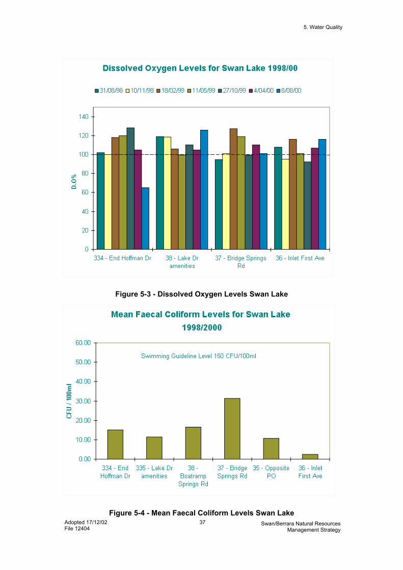
5. Water Quality
Adopted 17/12/02 File 12404
37 Swan/Berrara Natural Resources Management Strategy
Figure 5-3 - Dissolved Oxygen Levels Swan Lake
Figure 5-4 - Mean Faecal Coliform Levels Swan Lake

5. Water Quality
Adopted 17/12/02 File 12404
38 Swan/Berrara Natural Resources Management Strategy
Figure 5.5 - Nutrient Levels Swan Lake

5. Water Quality
Adopted 17/12/02 File 12404
39 Swan/Berrara Natural Resources Management Strategy
Figure 5.6 - Dissolved Oxygen Berrara Creek
Figure 5.7 - Mean Faecal Coliform Levels Berrara Creek

5. W
ater
Qua
lity
40
Swan
/Ber
rara
Nat
ural
Res
ourc
es M
anag
emen
t Stra
tegy
5.
4 ST
RA
TEG
IES
St
rate
gy
Act
ion
Prio
rity
Tim
ing
Estim
ated
C
ost
Res
pons
ibili
ty
Perf
orm
ance
Ev
alua
tion
WQ
1 - M
inim
ise
sew
age
cont
amin
atio
n of
Sw
an L
ake
and
Berra
ra C
reek
from
exi
stin
g se
wag
e m
anag
emen
t sys
tem
s
1.
Rev
iew
cou
ncil
data
on
sew
age
over
flow
s H
igh
Shor
t $1
000
SCC
D
ata
revi
ewed
2.
In
vest
igat
e op
tions
for
bund
ing
at o
verfl
ow p
oint
s M
ediu
m
Shor
t $2
000
SCC
Bu
ndin
g op
tions
es
tabl
ishe
d
3.
Iden
tify
sour
ce o
f co
ntam
inat
ion
of d
rain
age
line
that
runs
into
Ber
rara
Cre
ek
betw
een
Wat
erha
ven
Ave
and
Mea
dow
Lak
e Av
enue
Hig
h Sh
ort
$500
0 SC
C
Sour
ce o
f co
ntam
inat
ion
iden
tifie
d
4.
R
evie
w c
ost-e
ffect
ive
mea
sure
s fo
r red
ucin
g se
wag
e co
ntam
inat
ion
of
wat
erw
ays
Hig
h Sh
ort
Unc
oste
d SC
C
Rev
iew
co
mpl
eted
5.
C
ontin
ue to
mon
itor L
ake
and
Cre
ek fo
r ind
icat
ion
of s
ewag
e co
ntam
inat
ion
Hig
h O
ngoi
ng
No
addi
tiona
l co
st
SCC
C
omm
unity
Q
uarte
rly
test
ing
com
plet
ed
WQ
2 - I
mpr
ove
syst
em fo
r reu
se
and
disp
osal
of e
fflue
nt fr
om
retic
ulat
ed s
ewer
age
sche
me
6.
Augm
enta
tion
of e
xist
ing
faci
litie
s by
usi
ng o
pen
basi
n sa
nd d
une
exfil
tratio
n sy
stem
, su
bjec
t to
envi
ronm
enta
l im
pact
ass
essm
ent
Med
ium
D
epen
ds
on
avai
labi
lity
of fu
nds
$833
,000
SC
C
DLW
C
Augm
enta
tion
com
plet
ed,
subj
ect t
o en
viro
nmen
tal
impa
ct
asse
ssm
ent
7.
Fu
rther
inve
stig
ate
reus
e of
so
me
recl
aim
ed w
ater
on
Thom
son
Stre
et R
eser
ve,
Suss
ex In
let
Hig
h Sh
ort
$30,
000
SCC
Inve
stig
atio
n co
mpl
eted

5. W
ater
Qua
lity
41
Swan
/Ber
rara
Nat
ural
Res
ourc
es M
anag
emen
t Stra
tegy
Stra
tegy
A
ctio
n Pr
iorit
y Ti
min
g Es
timat
ed
Cos
t R
espo
nsib
ility
Pe
rfor
man
ce
Eval
uatio
n
8.
Incr
ease
aw
aren
ess
amon
gst
rura
l lan
d ow
ners
on
poss
ible
us
es o
f wat
er re
clai
med
from
se
wag
e
Med
ium
M
ediu
m
- SC
C
Con
sulta
tion
com
plet
ed
WQ
3 - C
ontro
l oth
er p
ollu
tant
s at
so
urce
9.
Ed
ucat
e pe
t ow
ners
to c
olle
ct
anim
al fa
eces
and
dis
pose
of
in s
ewer
or c
ompo
st
Med
ium
M
ediu
m
$100
0 SC
C
Educ
atio
n pr
ogra
m
com
plet
ed
10
. Edu
cate
resi
dent
s on
ap
prop
riate
use
of c
hem
ical
s an
d fe
rtilis
er in
hou
se a
nd
gard
en
Med
ium
M
ediu
m
$100
0 SC
C
Com
mun
ity
Educ
atio
n pr
ogra
m
com
plet
ed
11
. Ens
ure
min
imal
sed
imen
t and
nu
trien
t exp
ort f
rom
all
new
de
velo
pmen
ts in
rura
l are
as
Hig
h Sh
ort
No
publ
ic
cost
SC
C
Dev
elop
men
t co
ntro
ls in
pl
ace
12
. Ens
ure
that
are
as w
ith h
igh
risk
of a
cid
sulfa
te s
oils
are
no
t dra
ined
or e
xcav
ated
w
ithou
t app
ropr
iate
de
velo
pmen
t con
trols
Hig
h O
ngoi
ng
Unc
oste
d SC
C
No
acid
runo
ff to
cre
ek
WQ
4 - M
inim
ise
pollu
tant
tra
nspo
rt in
sto
rmw
ater
dra
ins
13. R
etai
n ve
geta
tion
linin
g in
's
oft'
drai
ns
Hig
h Sh
ort
No
addi
tiona
l co
st
SCC
St
rate
gy
adop
ted
by
Cou
ncil
14
. Whe
n ne
cess
ary,
rem
ove
sedi
men
t fro
m d
rain
s in
se
ctio
ns, l
eavi
ng ti
me
for o
ne
sect
ion
to re
cove
r bef
ore
dist
urba
nce
of n
ext s
ectio
n
Med
ium
Sh
ort
No
addi
tiona
l co
st
SCC
St
rate
gy
adop
ted
by
Cou
ncil
15
. Ens
ure
new
or r
emod
elle
d dr
ains
are
des
igne
d w
ith
adeq
uate
cap
acity
to
inco
rpor
ate
vege
tatio
n
Med
ium
M
ediu
m
Varia
ble
SCC
SC
C in
tern
al
desi
gn
guid
elin
e ad
opte
d

5. W
ater
Qua
lity
42
Swan
/Ber
rara
Nat
ural
Res
ourc
es M
anag
emen
t Stra
tegy
Stra
tegy
A
ctio
n Pr
iorit
y Ti
min
g Es
timat
ed
Cos
t R
espo
nsib
ility
Pe
rfor
man
ce
Eval
uatio
n
16. C
ontin
ue to
edu
cate
Cou
ncil
field
sta
ff in
bes
t pra
ctic
e fo
r st
orm
wat
er m
anag
emen
t
Med
ium
Sh
ort
$100
0 SC
C
Educ
atio
n pr
ogra
m
com
plet
ed
17
. Use
bes
t pra
ctic
e se
dim
ent
cont
rols
whe
n w
orki
ng in
dr
ains
Hig
h Sh
ort
No
addi
tiona
l co
st
SCC
SC
C in
tern
al
desi
gn
guid
elin
e ad
opte
d
18. I
nves
tigat
e ne
ed fo
r dev
ices
to
inte
rcep
t pol
luta
nts
at
stor
mw
ater
out
lets
in
Goo
naw
arra
Driv
e, C
ollie
r D
rive,
Koo
lyn
Driv
e, L
akel
and
Aven
ue a
nd W
ater
have
n Av
enue
Low
M
ediu
m
$100
0 SC
C
Inve
stig
atio
n co
mpl
eted
WQ
5 - E
nsur
e bo
atin
g is
not
co
ntam
inat
ing
lake
wat
er
19. T
est l
ake
wat
er fo
r co
ntam
inan
ts in
dica
tive
of fu
el
and
boat
mot
or e
xhau
st a
nd if
ne
cess
ary
inve
stig
ate
met
hods
of c
ontro
l
Med
ium
Sh
ort
$200
0 SC
C
Test
ing
com
plet
ed
WQ
6 –
Mon
itor w
ater
qua
lity
20. C
ontin
ue m
onito
ring
of w
ater
qu
ality
in la
ke a
nd c
reek
and
in
form
task
forc
e of
resu
lts
Med
ium
O
ngoi
ng
No
addi
tiona
l co
st
SCC
Q
uarte
rly
test
ing
com
plet
ed
21
. Inv
estig
ate
info
rmat
ion
requ
irem
ents
for u
tilis
atio
n of
20
00 A
NZE
CC
Aus
tralia
n W
ater
Qua
lity
Gui
delin
es
Med
ium
M
ediu
m
Unc
oste
d SC
C
Inve
stig
atio
n co
mpl
eted
WQ
7 - E
duca
te re
side
nts
and
visi
tors
on
stor
mw
ater
issu
es a
nd
solu
tions
22. I
mpl
emen
t Sto
rmw
ater
M
anag
emen
t Pla
n ed
ucat
ion
initi
ativ
es
Med
ium
Sh
ort
Ref
er
Stor
mw
ater
M
anag
emen
t Pl
an
SCC
Ed
ucat
ion
prog
ram
s co
mpl
eted

6. Erosion and Sedimentation
Adopted 17/12/02 File 12404
43 Swan/Berrara Natural Resources Management Strategy
6 EROSION AND SEDIMENTATION
6.1 VALUES Stable soils and creek banks mean that land remains productive, either for sustaining ecological communities or supporting human uses. Coastal waterways are subject to some natural infilling by sediment transported from the catchment and eroded from banks.
6.2 OBJECTIVES To minimise the erosion of soil from the catchments and creek banks and to protect Swan Lake and Berrara Creek from excessive sedimentation.
6.3 ISSUES Accelerated sediment deposition has a detrimental effect on ecology of waterways. The sediment loads of Swan Lake and Berrara Creek are contributed to from erosion of tracks and old gravel pits in the national park, as well as erosion of unsealed road verges and stormwater drains in the villages and rural residential areas. Soil washed or driven off building sites enters the stormwater system and ultimately the waterways. There is bank erosion in some of the more heavily used recreational areas on the eastern shore of Swan Lake. There is bank erosion adjacent to the Berrara Creek Flats Reserve.

6. E
rosi
on a
nd S
edim
enta
tion
44
Swan
/Ber
rara
Nat
ural
Res
ourc
es M
anag
emen
t Stra
tegy
6.
4 ST
RA
TEG
IES
St
rate
gy
Act
ion
Prio
rity
Tim
ing
Estim
ated
C
ost
Res
pons
ibili
ty
Perf
orm
ance
Ev
alua
tion
ER1
- Acc
omm
odat
e na
tura
l pr
oces
ses
of la
ke a
nd c
reek
ban
k er
osio
n an
d ac
cret
ion,
but
redu
ce
hum
an-in
duce
d er
osio
n
23. E
nsur
e ne
w d
evel
opm
ents
co
mpl
y w
ith d
evel
opm
ent
cont
rol p
lan
for f
ores
hore
s an
d st
atut
ory
requ
irem
ents
Hig
h C
ase
by
case
Va
riabl
e SC
C
DLW
C
No
furth
er
encr
oach
men
t on
cre
ek
bank
s
24. D
isal
low
furth
er d
evel
opm
ent
that
wou
ld c
ause
lake
or
cree
k ba
nk e
rosi
on a
nd re
tain
an
d/or
re-e
stab
lish
ripar
ian
vege
tatio
n al
ong
cree
k ba
nks
Hig
h O
ngoi
ng
- SC
C
DLW
C
Eros
ion
redu
ced
ER2
- Red
uce
amou
nt o
f se
dim
ent e
nter
ing
the
cree
ks,
lake
and
wet
land
s fro
m th
e ca
tchm
ents
by
cont
rollin
g er
osio
n at
its
sour
ces
25. U
nder
take
sed
imen
t and
er
osio
n co
ntro
l on
build
ing
site
s
Med
ium
Sh
ort
Varia
ble
Build
ers
SCC
Be
st
man
agem
ent
prac
tices
w
idel
y us
ed
26
. Edu
cate
bui
lder
s on
ap
prop
riate
soi
l, w
aste
and
w
ater
man
agem
ent o
n bu
ildin
g si
tes
Med
ium
Sh
ort
$100
0 SC
C
Educ
atio
n pr
ogra
m
com
plet
ed
27
. Enf
orce
ant
i-pol
lutio
n la
ws
on
build
ing
site
s an
d ot
her a
reas
w
here
ther
e is
soi
l di
stur
banc
e
Hig
h O
ngoi
ng
- SC
C
Min
imal
soi
l w
ashi
ng fr
om
build
ing
site
s
28
. Dev
elop
a s
trate
gy b
etw
een
Cou
ncil
and
the
com
mun
ity
for t
he s
tabi
lisat
ion
and
vege
tatio
n of
uns
eale
d ro
ad
verg
es in
urb
an a
reas
Hig
h Sh
ort
$500
0 SC
C
Stra
tegy
ag
reed
and
ad
opte
d

6. E
rosi
on a
nd S
edim
enta
tion
45
Swan
/Ber
rara
Nat
ural
Res
ourc
es M
anag
emen
t Stra
tegy
Stra
tegy
A
ctio
n Pr
iorit
y Ti
min
g Es
timat
ed
Cos
t R
espo
nsib
ility
Pe
rfor
man
ce
Eval
uatio
n
29. S
tabi
lise
unse
aled
road
ve
rges
in th
e vi
llage
and
rura
l ar
eas
Hig
h Sh
ort
$200
00
SCC
N
o so
il m
obilis
ed fr
om
road
ver
ges
30
. Mai
ntai
n ve
geta
tion
in ro
ad
verg
es to
min
imis
e er
osio
n an
d tra
p po
lluta
nts
Hig
h Sh
ort
- C
omm
unity
SC
C
Stab
le
vege
tatio
n ro
ad v
erge
s
31. S
tabi
lise
fire
trails
and
oth
er
unse
aled
veh
icle
trac
ks
Med
ium
M
ediu
m
$500
00
NPW
S D
LWC
SC
C
Inte
gral
Ene
rgy
Trac
k up
grad
e co
mpl
ete
32
. Sta
bilis
e ac
cess
road
to
Swan
have
n bo
at ra
mp
rese
rve
(Spr
ings
Res
erve
)
Med
ium
Sh
ort
$200
0 SC
C
Roa
d st
abilis
ed
33
. Sta
bilis
e ol
d gr
avel
pits
in
natio
nal p
ark
Med
ium
M
ediu
m
$300
00
NPW
S Pi
ts s
tabl
e

7. Nature Conservation
Adopted 17/12/02 File 12404
46 Swan/Berrara Natural Resources Management Strategy
7 NATURE CONSERVATION
7.1 VALUES Swan Lake, Berrara Creek and their catchments support a range of relatively undisturbed ecological communities, which is important from a conservation perspective and is also an attractive attribute of the area for many residents and visitors. The following specific nature conservation values were identified during the preparation of this NRMS: 1. Swan Lake, Berrara Creek and
their catchment support a great variety of habitats. The area is known to be a biodiversity hotspot, with nearly 500 plant species, 150 bird species, and at least 23 native mammal species known to occur in the area.
2. There is little development in the catchments and large areas of land remain in unspoilt condition with their original floristic composition and structure. Most of the catchment areas lie in the Conjola National Park.
3. The fish, shellfish, crustaceans and other aquatic species are a valuable resource. There are links between the animal populations that live in the lake and creeks and those in the sea.
4. Healthy seagrass, algae and foreshore vegetation provide important habitats, oxygenate the water and assist to stabilise the sediments on the lake and creek beds.
5. A range of internationally protected wading birds use the foreshore vegetation, sand and mud flats, rocky shores, beach sands and wetlands for feeding, resting and breeding sites. Large populations of swans and other water birds are present on the lake when conditions are favourable. Over
10,000 White-eyed Duck (Aythya australis) were recorded in August-September 2001, as well as large numbers of Black Swan (Cygnus atratus) which represent the overflow from Lake Wollumboola (Coast and Wetlands Society, 2002). The lake is home to White Bellied Sea Eagles (Haliaeetus leucogaster) and, at certain times of the year, to migratory species including Spine-tailed Swift (Hirundapus caudacutus) and Whiskered Tern (Chlidonias hybrida), as well as Little (Ardea garzetta), Intermediate (Ardea intermedia) and Great Egret (Ardea alba). These species are variously covered by international agreements (CAMBA/JAMBA/Bonn Convention), and/or protected under the Commonwealth Environment Protection and Biodiversity Conservation Act 1999 and the NSW National Parks and Wildlife Act 1974.”
6. Wetlands to the north of Swan Lake and at the mouths of Mondayong and Teatree Creeks are protected under Coastal Wetlands State Environmental Planning Policy No 14. Other wetlands to the west and south are also significant.
7. Other vegetation types include heathlands, woodlands and some forests. Significant Bangalay-rainforest vegetation is present on the sand dunes to the east of Swan Lake.
8. Populations of a number of rare or threatened plant and animal species are known to exist in the area. These include Black Bittern, Pied Oystercatcher, Sooty Oystercatcher, Osprey, Hooded Plover, Powerful Owl, Glossy Black Cockatoo, Regent Honeyeater and the saltmarsh plants Wilsonia backhousia and Wilsonia rotundifolia. The Hooded Plover (Endangered) and Pied

7. Nature Conservation
Adopted 17/12/02 File 12404
47 Swan/Berrara Natural Resources Management Strategy
Oystercatcher (Vulnerable) have been recorded nesting at the entrances to both Swan Lake and Berrara Creek. They nest from October to February and may be affected if the lake is opened artificially during this time. This is one of the most important locality of Hooded Plovers in Australia (NPWS, 2002).
9. Native animals can still be seen in the villages.
7.2 OBJECTIVES To maintain or, where appropriate, restore the ecological integrity and biodiversity of Swan Lake, Berrara Creek, their foreshores and their catchments.
7.3 ISSUES The issues investigated during the preparation of this NRMS were: 1. Introduced animals, including
foxes, domestic and feral cats and dogs, black rats and rabbits, threaten native animal and plant populations.
2. Weeds, although scarce overall, are prevalent in some areas where they threaten native plant communities.
3. Dumping of garden refuse and other material causes damage to bushland. This dumping is illegal. Council officers are authorised to take action against dumpers and can issue on-the-spot fines.
4. Artificial opening of Swan Lake to the sea affects the natural fluctuations in populations of fish and other aquatic species and affects foreshore vegetation and wetlands. This is dealt with in section 7.
5. Significant vegetation and populations of threatened and rare
species exist on land that is not part of a reserve system.
6. There is some damage and clearance of vegetation on foreshores and other areas.
7. There is a risk that the invasive marine seaweed Caulerpa taxifolia could be introduced to the lake. This presents a threat to the biological diversity, amenity and economic viability of local tourist industries that depend on healthy coastal lakes in the Shoalhaven.

7. N
atur
e C
onse
rvat
ion
48
Swan
/Ber
rara
Nat
ural
Res
ourc
es M
anag
emen
t Stra
tegy
7.
4 ST
RA
TEG
IES
St
rate
gy
Act
ion
Prio
rity
Tim
ing
Estim
ated
C
ost
Res
pons
ibili
ty
Perf
orm
ance
Ev
alua
tion
NC
1 - P
rote
ct s
igni
fican
t ec
olog
ical
com
mun
ities
and
po
pula
tions
of r
are
or th
reat
ened
sp
ecie
s th
at a
re n
ot in
rese
rve
syst
em
34. E
stab
lish
volu
ntar
y co
nser
vatio
n ag
reem
ents
with
pr
ivat
e la
nd o
wne
rs
Med
ium
M
ediu
m
- N
PWS
DLW
C
Com
mun
ity
VCAs
es
tabl
ishe
d
35
. Man
age
the
dune
fore
st
betw
een
Cud
mirr
ah B
each
an
d Sw
an L
ake
for
cons
erva
tion
purp
oses
Med
ium
M
ediu
m
- D
LWC
D
MR
SC
C
Com
mun
ity
Fore
st
pres
erve
d
36
. Inv
estig
ate
capa
bilit
y an
d ap
prop
riate
use
s of
Cro
wn
land
to w
est o
f Cud
mirr
ah
Med
ium
Sh
ort
- D
LWC
La
nd
asse
ssm
ent
com
plet
ed
NC
2 - R
etai
n th
e na
tura
l sta
te o
f th
e C
udm
irrah
dun
es
37. D
evel
op a
nd im
plem
ent
man
agem
ent o
ptio
ns fo
r pr
even
ting
serio
us h
uman
-in
duce
d er
osio
n of
the
Cud
mirr
ah d
unes
, in
clos
e co
nsul
tatio
n w
ith th
e co
mm
unity
and
com
mun
ity
grou
ps in
clud
ing
the
Cud
mirr
ah/B
erra
ra D
une
Car
e G
roup
Hig
h Sh
ort
Unc
oste
d SC
C
Hum
an-
indu
ced
eros
ion
redu
ced
NC
3 - P
rote
ct th
e na
tura
l val
ues
of fo
resh
ores
and
wet
land
s 38
. Whe
n ne
xt re
zoni
ng a
ny la
nd
in th
e ar
ea, i
ncor
pora
te
obje
ctiv
e of
hav
ing
envi
ronm
enta
l pro
tect
ion
for
fore
shor
es a
nd w
etla
nds,
and
co
nsid
er a
ppro
pria
te z
onin
g
Med
ium
M
ediu
m
- SC
C
Rez
onin
g co
mpl
eted

7. N
atur
e C
onse
rvat
ion
49
Swan
/Ber
rara
Nat
ural
Res
ourc
es M
anag
emen
t Stra
tegy
Stra
tegy
A
ctio
n Pr
iorit
y Ti
min
g Es
timat
ed
Cos
t R
espo
nsib
ility
Pe
rfor
man
ce
Eval
uatio
n N
C4
- Edu
cate
vis
itors
and
re
side
nts
on im
porta
nce
of
prot
ectin
g na
tura
l val
ues
39. P
repa
re b
roch
ures
and
in
terp
retiv
e si
gns
abou
t fo
resh
ores
and
urb
an
bush
land
for e
duca
tion
of
resi
dent
s an
d vi
sito
rs
Hig
h Sh
ort
$200
0 SC
C
Broc
hure
pr
epar
ed a
nd
dist
ribut
ed
40
. Ide
ntify
mos
t lik
ely
sour
ces
of
dum
ped
law
n cl
ippi
ngs
and
gard
en w
aste
in b
ushl
and
and
on d
une.
Med
ium
Sh
ort
$100
0 SC
C
Inve
stig
atio
n co
mpl
eted
41
. Con
duct
targ
eted
cam
paig
n to
al
ter b
ehav
iour
of g
arde
n w
aste
dum
pers
Med
ium
Sh
ort
$150
0 SC
C
NPW
S D
LWC
Abse
nce
of
rubb
ish
in
bush
land
ar
eas
NC
5 - R
emov
e pi
les
of g
arde
n w
aste
from
pub
lic a
reas
42
. Foc
us C
lean
Up
Aust
ralia
vo
lunt
eers
on
colle
ctio
n of
du
mpe
d ga
rden
was
te fr
om
publ
ic a
reas
Med
ium
Sh
ort
- C
lean
up
Aust
ralia
vo
lunt
eers
Rub
bish
re
mov
ed fr
om
natu
ral a
reas
43
. Rem
ove
rubb
ish
mou
nd fr
om
road
rese
rve
near
Ber
rara
Be
ach
acce
ssw
ay
Hig
h Sh
ort
$500
0 SC
C
Adja
cent
land
ow
ners
Rub
bish
re
mov
ed
44
. Edu
cate
ow
ners
or
man
agem
ent a
nd s
taff
of
prop
ertie
s ad
jace
nt to
pub
lic
rese
rves
on
appr
opria
te w
aste
di
spos
al
Hig
h Sh
ort
$200
0 SC
C
Rub
bish
no
long
er d
umpe
d
NC
6 - C
ontro
l wee
ds in
bus
hlan
d ar
eas
45. S
urve
y w
eeds
in b
ushl
and
and
deve
lop
a w
eed
cont
rol
actio
n pl
an
Hig
h Sh
ort
$100
0 SC
C
Plan
pre
pare
d
46
. Tra
in b
ush
care
vol
unte
ers
in
impl
emen
tatio
n of
wee
d co
ntro
l act
ion
plan
Med
ium
M
ediu
m
$600
0 SC
C
NPW
S
Trai
ning
co
mpl
eted

7. N
atur
e C
onse
rvat
ion
50
Swan
/Ber
rara
Nat
ural
Res
ourc
es M
anag
emen
t Stra
tegy
Stra
tegy
A
ctio
n Pr
iorit
y Ti
min
g Es
timat
ed
Cos
t R
espo
nsib
ility
Pe
rfor
man
ce
Eval
uatio
n
47. E
stab
lish
wee
d re
mov
al
prog
ram
for B
erra
ra C
reek
Fl
ats
Res
erve
and
in
ters
ectio
n of
Wat
erha
ven
and
Lake
land
Ave
nues
Hig
h Sh
ort
$500
0 SC
C
Com
mun
ity
Wee
ds
redu
ced
48
. If n
eces
sary
, est
ablis
h pr
ojec
t un
der l
abou
r pro
visi
on
prog
ram
(eg,
Gre
enco
rp,
Wor
k fo
r the
Dol
e, C
omm
unity
Se
rvic
e) to
targ
et w
eed
infe
stat
ions
in b
ushl
and
area
s
Hig
h Sh
ort
$300
0 SC
C
NPW
S D
LWC
Wee
ds
redu
ced
NC
7 - P
rote
ct la
ke a
nd c
reek
fro
m in
trodu
ctio
n of
Cau
lerp
a ta
xifo
lia
49. C
ondu
ct e
duca
tion
(sig
ns,
broc
hure
s, e
tc) t
o re
duce
lik
elih
ood
of in
fest
atio
n or
to
impr
ove
chan
ce o
f ear
ly
dete
ctio
n if
it is
intro
duce
d
Hig
h Sh
ort
$200
0 N
SW F
ishe
ries
SCC
In
fest
atio
n pr
even
ted
or
dete
cted
NC
8 - M
aint
ain
or e
stab
lish
buffe
r zo
nes
betw
een
deve
lope
d ar
eas
and
sens
itive
hab
itats
, whe
re
poss
ible
50. M
aint
ain
exis
ting
area
s of
na
tive
vege
tatio
n, p
artic
ular
ly
on fo
resh
ores
Hig
h O
ngoi
ng
- SC
C
NPW
S D
LWC
C
omm
unity
No
loss
of
fore
shor
e ve
geta
tion
51
. Res
tore
som
e ar
eas
of n
ativ
e ve
geta
tion
on B
erra
ra C
reek
Fl
ats
Res
erve
, Lak
elan
d Av
enue
Res
erve
, Erro
l Bon
d R
eser
ve, e
aste
rn fo
resh
ore
of
lake
and
Ber
rara
hea
dlan
d,
whi
lst m
aint
aini
ng a
cces
s to
w
ater
way
s
Med
ium
Sh
ort
$500
0 SC
C
Com
mun
ity
Rev
eget
atio
n pr
ogra
m
com
plet
ed

7. N
atur
e C
onse
rvat
ion
51
Swan
/Ber
rara
Nat
ural
Res
ourc
es M
anag
emen
t Stra
tegy
Stra
tegy
A
ctio
n Pr
iorit
y Ti
min
g Es
timat
ed
Cos
t R
espo
nsib
ility
Pe
rfor
man
ce
Eval
uatio
n
52. P
rote
ct e
xist
ing
vege
tatio
n fro
m v
anda
lism
on
fore
shor
es,
eg, a
djac
ent t
o G
oona
war
ra
Driv
e, th
e ea
ster
n fo
resh
ore
of S
wan
Lak
e an
d Be
rrara
H
eadl
and
Med
ium
Sh
ort
- SC
C
Enfo
rcem
ent
effe
ctiv
e
NC
9 - C
ontro
l pop
ulat
ions
of
intro
duce
d an
imal
s in
nat
ural
ar
eas
53. D
evel
op a
nd im
plem
ent j
oint
fe
ral a
nim
al c
ontro
l pro
gram
M
ediu
m
Med
ium
$1
0000
SC
C
DLW
C
NPW
S
Plan
im
plem
ente
d
NC
10 -
Red
uce
impa
ct o
f ro
amin
g do
mes
tic a
nim
als
on
nativ
e an
imal
pop
ulat
ions
54. E
duca
te re
side
nts
and
visi
tors
on
thei
r obl
igat
ions
und
er th
e C
ompa
nion
Ani
mal
s Ac
t
Med
ium
Sh
ort
$400
0 SC
C
Educ
atio
n ca
mpa
ign
impl
emen
ted
55
. Enf
orce
pro
visi
ons
of
Com
pani
on A
nim
als
Act
Hig
h O
ngoi
ng
- SC
C
Enfo
rcem
ent
effe
ctiv
e N
C11
– R
educ
e im
pact
of m
otor
ve
hicl
e dr
iver
s on
wild
life
popu
latio
ns
56. R
evie
w s
peed
lim
its o
n ro
ads
outs
ide
urba
n ar
eas
Med
ium
M
ediu
m
- SC
C
NPW
S N
umbe
r of
road
kills
re
duce
d
57. I
dent
ify a
nim
al ro
ad k
ill bl
ack
spot
s an
d si
gnpo
st
Med
ium
M
ediu
m
$200
0 N
PWS
SCC
N
ANA
Num
ber o
f ro
ad k
ills
redu
ced

8. Entrance Management
Adopted 17/12/02 File 12404
52 Swan/Berrara Natural Resources Management Strategy
8 ENTRANCE MANAGEMENT
8.1 VALUES Swan Lake is typical of many south coast lagoons in that it is usually closed to the sea by a sand bar. The condition of the lake's entrance plays an important part in the state of the estuarine ecosystem. Figure 8-1 shows the entrance in both open and closed conditions.
8.2 OBJECTIVES To reinstate, in the longer term, natural entrance behaviour and hence natural rates of change in water levels.
8.3 ISSUES The entrance to Swan Lake has, in the past, been artificially opened by Shoalhaven City Council when the lake water reaches a designated level (1.25 m above AHD). The designated level at which the lake may be opened is well below the level to which the lake has been allowed to fill in recent years. The most recent opening of the lake was caused by floodwaters, not by human intervention, and the lake level reached 2.5 m above AHD on that occasion. There is localised flooding when the lake reaches this level, just south of the Collier Drive bridge at Cudmirrah, and on the access track to The Springs holiday cabins at Swanhaven. It is claimed that the location at which the entrance opens affects the level to which the lake water drops because of the presence of an underlying rock shelf. It is also claimed that this affects the length of time that the entrance stays open and affects surfing spots.
There have been a number of unauthorised openings of the lake by members of the public.
8. Entrance Management
Adopted 17/12/02 File 12404
53 Swan/Berrara Natural Resources Management Strategy
Figure 8-1. Top – entrance closed May 1998. Bottom – 4 days after opening August 1998.
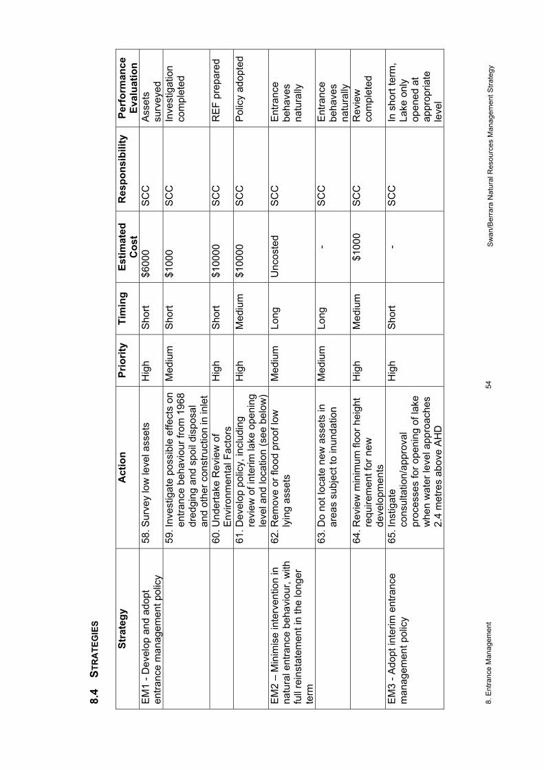
8. E
ntra
nce
Man
agem
ent
54
Swan
/Ber
rara
Nat
ural
Res
ourc
es M
anag
emen
t Stra
tegy
8.
4 ST
RA
TEG
IES
St
rate
gy
Act
ion
Prio
rity
Tim
ing
Estim
ated
C
ost
Res
pons
ibili
ty
Perf
orm
ance
Ev
alua
tion
EM1
- Dev
elop
and
ado
pt
entra
nce
man
agem
ent p
olic
y 58
. Sur
vey
low
leve
l ass
ets
Hig
h Sh
ort
$600
0 SC
C
Asse
ts
surv
eyed
59. I
nves
tigat
e po
ssib
le e
ffect
s on
en
tranc
e be
havi
our f
rom
196
8 dr
edgi
ng a
nd s
poil
disp
osal
an
d ot
her c
onst
ruct
ion
in in
let
Med
ium
Sh
ort
$100
0 SC
C
Inve
stig
atio
n co
mpl
eted
60
. Und
erta
ke R
evie
w o
f En
viro
nmen
tal F
acto
rs
Hig
h Sh
ort
$100
00
SCC
R
EF p
repa
red
61
. Dev
elop
pol
icy,
incl
udin
g re
view
of i
nter
im la
ke o
peni
ng
leve
l and
loca
tion
(see
bel
ow)
Hig
h M
ediu
m
$100
00
SCC
Po
licy
adop
ted
EM2
– M
inim
ise
inte
rven
tion
in
natu
ral e
ntra
nce
beha
viou
r, w
ith
full
rein
stat
emen
t in
the
long
er
term
62. R
emov
e or
floo
d pr
oof l
ow
lyin
g as
sets
M
ediu
m
Long
U
ncos
ted
SCC
En
tranc
e be
have
s na
tura
lly
63
. Do
not l
ocat
e ne
w a
sset
s in
ar
eas
subj
ect t
o in
unda
tion
Med
ium
Lo
ng
- SC
C
Entra
nce
beha
ves
natu
rally
64. R
evie
w m
inim
um fl
oor h
eigh
t re
quire
men
t for
new
de
velo
pmen
ts
Hig
h M
ediu
m
$100
0 SC
C
Rev
iew
co
mpl
eted
EM3
- Ado
pt in
terim
ent
ranc
e m
anag
emen
t pol
icy
65. I
nstig
ate
cons
ulta
tion/
appr
oval
pr
oces
ses
for o
peni
ng o
f lak
e w
hen
wat
er le
vel a
ppro
ache
s 2.
4 m
etre
s ab
ove
AHD
Hig
h Sh
ort
- SC
C
In s
hort
term
, La
ke o
nly
open
ed a
t ap
prop
riate
le
vel

8. E
ntra
nce
Man
agem
ent
55
Swan
/Ber
rara
Nat
ural
Res
ourc
es M
anag
emen
t Stra
tegy
Stra
tegy
A
ctio
n Pr
iorit
y Ti
min
g Es
timat
ed
Cos
t R
espo
nsib
ility
Pe
rfor
man
ce
Eval
uatio
n
66. O
pen
lake
at s
outh
ern
side
of
entra
nce
spit
so th
at w
ater
flo
ws
over
rock
she
lf
Hig
h As
re
quire
d -
SCC
La
ke o
nly
open
ed a
t so
uthe
rn
loca
tion
EM4
- Pre
vent
ille
gal o
peni
ng o
f la
ke e
ntra
nce
67. M
aint
ain
sign
s at
ent
ranc
e ac
cess
way
s M
ediu
m
Ong
oing
$2
000
SCC
D
LWC
La
ke n
ot
open
ed
illega
lly
68
. Pro
secu
te p
eopl
e fo
und
atte
mpt
ing
to o
pen
lake
M
ediu
m
As
requ
ired
- SC
C
DLW
C
NSW
Fis
herie
s
Lake
not
op
ened
ille
gally

9. Recreation
Adopted 17/12/02 File 12404
56 Swan/Berrara Natural Resources Management Strategy
9 RECREATION
9.1 VALUES Swan Lake and Berrara are used for a diverse range of aquatic recreational activities including sailing, canoeing, water skiing, jet skiing, fishing, prawning, swimming, and birdwatching. The foreshores and natural areas around the waterways are used for picnicking, walking, biking, horse riding and other recreational activities. The area is a recreational destination for families, with a safe environment for young children.
9.2 OBJECTIVES To ensure that recreational activities do not have undue effects on the nature and enjoyment of the area.
9.3 ISSUES Powerboat usage in the Swan Lake may adversely affect swimming and other water-based activities. Noise from powerboats is offensive to some people. Powerboat usage can disturb wildlife, particularly water birds. At peak times there can be some overcrowding of recreational facilities. The standard of environmental protection at some facilities such as picnic areas and boat ramps is not adequate for the level of usage. Access along foreshore of Berrara Creek is impeded by creek below Waterhaven Avenue.
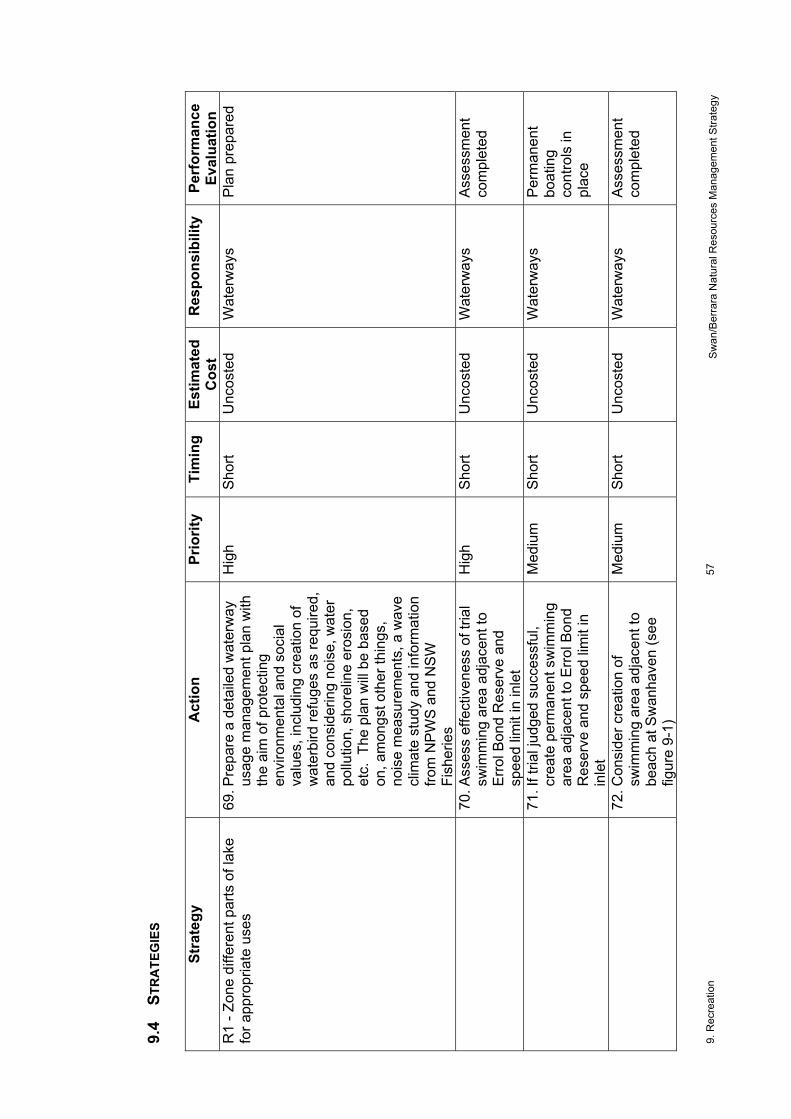
9. R
ecre
atio
n 57
Sw
an/B
erra
ra N
atur
al R
esou
rces
Man
agem
ent S
trate
gy
9.4
STR
ATE
GIE
S
Stra
tegy
A
ctio
n Pr
iorit
y Ti
min
g Es
timat
ed
Cos
t R
espo
nsib
ility
Pe
rfor
man
ce
Eval
uatio
n R
1 - Z
one
diffe
rent
par
ts o
f lak
e fo
r app
ropr
iate
use
s
69. P
repa
re a
det
aile
d w
ater
way
us
age
man
agem
ent p
lan
with
th
e ai
m o
f pro
tect
ing
envi
ronm
enta
l and
soc
ial
valu
es, i
nclu
ding
cre
atio
n of
w
ater
bird
refu
ges
as re
quire
d,
and
cons
ider
ing
nois
e, w
ater
po
llutio
n, s
hore
line
eros
ion,
et
c. T
he p
lan
will
be b
ased
on
, am
ongs
t oth
er th
ings
, no
ise
mea
sure
men
ts, a
wav
e cl
imat
e st
udy
and
info
rmat
ion
from
NPW
S an
d N
SW
Fish
erie
s
Hig
h Sh
ort
Unc
oste
d W
ater
way
s Pl
an p
repa
red
70
. Ass
ess
effe
ctiv
enes
s of
tria
l sw
imm
ing
area
adj
acen
t to
Erro
l Bon
d R
eser
ve a
nd
spee
d lim
it in
inle
t
Hig
h Sh
ort
Unc
oste
d W
ater
way
s As
sess
men
t co
mpl
eted
71
. If t
rial j
udge
d su
cces
sful
, cr
eate
per
man
ent s
wim
min
g ar
ea a
djac
ent t
o Er
rol B
ond
Res
erve
and
spe
ed li
mit
in
inle
t
Med
ium
Sh
ort
Unc
oste
d W
ater
way
s Pe
rman
ent
boat
ing
cont
rols
in
plac
e
72
. Con
side
r cre
atio
n of
sw
imm
ing
area
adj
acen
t to
beac
h at
Sw
anha
ven
(see
fig
ure
9-1)
Med
ium
Sh
ort
Unc
oste
d W
ater
way
s As
sess
men
t co
mpl
eted

9. R
ecre
atio
n 58
Sw
an/B
erra
ra N
atur
al R
esou
rces
Man
agem
ent S
trate
gy
Stra
tegy
A
ctio
n Pr
iorit
y Ti
min
g Es
timat
ed
Cos
t R
espo
nsib
ility
Pe
rfor
man
ce
Eval
uatio
n
73. R
etai
n Sw
anha
ven
ram
p fo
r la
unch
/retri
eval
by
smal
l cra
ft an
d en
sure
that
sig
nage
in
dica
tes
type
s of
cra
ft th
at
can
be u
sed
ther
e an
d lo
catio
n of
alte
rnat
ive
faci
litie
s fo
r oth
er c
raft
Hig
h O
ngoi
ng
Unc
oste
d SC
C
74
. Bas
ed o
n fu
rther
con
sulta
tion
and
colle
ctio
n of
furth
er
info
rmat
ion,
incl
udin
g in
form
atio
n on
usa
ge p
atte
rns
and
safe
ty is
sues
, inv
estig
ate
poss
ible
futu
re re
stric
tion
on
Swan
have
n ra
mp
that
wou
ld
only
allo
w m
anha
ndlin
g of
bo
ats
into
the
lake
Med
ium
M
ediu
m
Unc
oste
d SC
C
75
. Pro
vide
app
ropr
iate
ed
ucat
iona
l mat
eria
l on
boat
ing
rest
rictio
ns o
n la
ke
Hig
h Sh
ort
Unc
oste
d W
ater
way
s R
efug
e an
d sw
imm
ing
area
s cl
early
m
arke
d
76. I
nves
tigat
e po
ssib
le m
etho
ds
of m
akin
g ve
ssel
ope
rato
rs
and
swim
mer
s aw
are
of
swim
min
g ar
eas,
suc
h as
by
use
of s
igns
at r
amps
or
prov
isio
n of
map
s, to
avo
id
use
of v
isua
lly in
trusi
ve
float
ing
mar
kers
Med
ium
M
ediu
m
Unc
oste
d w
ater
way
s

9. R
ecre
atio
n 59
Sw
an/B
erra
ra N
atur
al R
esou
rces
Man
agem
ent S
trate
gy
Stra
tegy
A
ctio
n Pr
iorit
y Ti
min
g Es
timat
ed
Cos
t R
espo
nsib
ility
Pe
rfor
man
ce
Eval
uatio
n
77. E
ncou
rage
all
user
gro
ups
to
educ
ate
thei
r mem
bers
hip
of
the
impo
rtanc
e of
adh
erin
g to
bo
atin
g ru
les
and
resp
ectin
g th
e in
tere
sts
of o
ther
w
ater
way
use
rs
Hig
h Sh
ort
Unc
oste
d SC
C
Com
mun
ity
78
. Dra
w o
n ex
perti
se fr
om N
SW
Wat
erw
ays,
NPW
S, o
ther
ag
enci
es a
nd th
e co
mm
unity
to
dev
ise
and
cond
uct a
n ed
ucat
ion
cam
paig
n to
rais
e an
d m
aint
ain
awar
enes
s am
ongs
t all
recr
eatio
nal u
sers
of
pot
entia
l im
pact
s of
thei
r ac
tiviti
es o
n w
ater
bird
s, w
ater
qu
ality
, noi
se e
tc
Hig
h Sh
ort
Unc
oste
d SC
C
R2
- Pro
tect
fore
shor
es a
nd
publ
ic re
serv
es fr
om d
egra
datio
n du
e to
recr
eatio
nal u
se
79. P
rovi
de a
cces
s st
airs
or r
amp
to s
mal
l bea
ch a
rea
in E
rrol
Bond
Res
erve
, Cud
mirr
ah
Med
ium
M
ediu
m
$500
0 SC
C
Acce
ssw
ay
built
80
. For
mal
ise
road
s an
d pa
rkin
g in
Sw
an L
ake
boat
ram
p re
serv
e
Med
ium
M
ediu
m
$200
00
SCC
Ve
hicl
e ac
cess
ra
tiona
lised
81
. Inv
estig
ate
exte
nt, c
ause
s an
d po
ssib
le s
olut
ions
to
fore
shor
e er
osio
n ne
ar th
e m
ain
Swan
Lak
e bo
at ra
mp
Hig
h Sh
ort
$300
0 SC
C
Inve
stig
atio
n co
mpl
eted
82
. Ass
ess
dam
age
caus
ed b
y la
unch
ing
and
retri
eval
of
boat
s ot
her t
han
at
desi
gnat
ed ra
mps
Med
ium
M
ediu
m
$100
0 SC
C
Asse
ssm
ent
com
plet
ed

9. R
ecre
atio
n 60
Sw
an/B
erra
ra N
atur
al R
esou
rces
Man
agem
ent S
trate
gy
Stra
tegy
A
ctio
n Pr
iorit
y Ti
min
g Es
timat
ed
Cos
t R
espo
nsib
ility
Pe
rfor
man
ce
Eval
uatio
n R
3 - P
rovi
de a
cces
s to
pub
lic
fore
shor
e la
nd n
ext t
o Be
rrara
C
reek
83. I
nves
tigat
e fe
asib
ility
of
build
ing
a pe
dest
rian
brid
ge
over
the
unna
med
cre
ek
belo
w W
ater
have
n Av
enue
Med
ium
Lo
ng
$500
0 SC
C
Brid
ge b
uilt
R4
- Red
uce
impa
cts
of m
otor
ve
hicl
e dr
iver
s on
recr
eatio
nal
user
s of
fore
st ro
ads
56.
Rev
iew
spe
ed li
mits
on
road
s ou
tsid
e ur
ban
area
s M
ediu
m
Med
ium
-
SCC
N
PWS
Rev
iew
co
mpl
eted

9. R
ecre
atio
n 61
Sw
an/B
erra
ra N
atur
al R
esou
rces
Man
agem
ent S
trate
gy
Swan
Lak
e
Swan
have
n
Cud
mirr
ah
8 kn
ot z
one
Swim
min
g ar
ea
Mon
dayo
ng C
k
#
#ra
mpra
mp
no w
ash
zone
Swan
Lak
e
Swan
have
n
Cud
mirr
ah
Mon
dayo
ng C
k
#
#ra
mpra
mp
Prop
osed
swim
min
g ar
ea
Ret
ain
exis
ting
swim
min
g ar
ea
Ret
ain
exis
ting
8 kn
ot z
one
Add
4 kn
ot re
stric
tion
Ret
ain
no w
ash
zone
Inve
stig
ate
crea
tion
of
wate
r bird
refu
ge a
s pa
rt of
wat
erw
ay u
sage
m
anag
emen
t pla
n
Ex
istin
g
Pr
opos
ed
Fi
gure
9-1
. Exi
stin
g bo
atin
g re
stric
tions
and
pro
pose
d ch
ange
s on
Sw
an la
ke

10. Visual Quality
Adopted 17/12/02 File 12404
62 Swan/Berrara Natural Resources Management Strategy
10 VISUAL QUALITY
10.1 VALUES The scenic qualities of the area are major assets for both residents and visitors. The values derive from the creeks and their foreshores, the near and distant coastline (including the sea itself, beaches, headlands and cliffs), the large areas of native vegetation and the wildlife.
10.2 OBJECTIVES To maintain, rehabilitate where necessary and enhance where appropriate the high visual qualities of Swan Lake and Berrara Creek.
10.3 ISSUES Rubbish is washed onto beaches and into creeks and is dumped on public areas. Native vegetation is being removed from foreshore land. Buildings and other structures can degrade coastal scenery.

10. V
isua
l Qua
lity
63
Swan
/Ber
rara
Nat
ural
Res
ourc
es M
anag
emen
t Stra
tegy
10
.4 S
TRA
TEG
IES
St
rate
gy
Act
ion
Prio
rity
Tim
ing
Estim
ated
C
ost
Res
pons
ibili
ty
Perf
orm
ance
Ev
alua
tion
VQ1
- Mai
ntai
n or
rest
ore
visu
al
char
acte
r of n
atur
al la
ndsc
apes
an
d la
ndfo
rms
50. M
aint
ain
exis
ting
area
s of
na
tive
vege
tatio
n, p
artic
ular
ly
on fo
resh
ores
Hig
h O
ngoi
ng
- SC
C
NPW
S D
LWC
C
omm
unity
No
loss
of
fore
shor
e ve
geta
tion
51
. Res
tore
som
e ar
eas
of n
ativ
e ve
geta
tion
on B
erra
ra C
reek
Fl
ats
Res
erve
, La
kela
nd
Aven
ue R
eser
ve, E
rrol B
ond
Res
erve
, eas
tern
fore
shor
e of
la
ke a
nd B
erra
ra h
eadl
and,
w
hils
t mai
ntai
ning
acc
ess
to
wat
erw
ays
Med
ium
Sh
ort
$500
0 SC
C
Com
mun
ity
Rev
eget
atio
n co
mpl
eted
84
. Rem
ove
rubb
ish
from
bu
shla
nd a
nd b
each
es
Med
ium
Sh
ort
Unc
oste
d SC
C
NPW
S C
omm
unity
No
visi
ble
rubb
ish
85
. Con
duct
pub
lic e
duca
tion
on
impa
ct o
f rub
bish
on
envi
ronm
ent
Med
ium
M
ediu
m
$100
0 SC
C
Educ
atio
n pr
ogra
m
com
plet
ed
VQ2
- Ens
ure
built
form
s do
not
im
pact
adv
erse
ly o
n co
asta
l sc
ener
y
86. E
nsur
e ne
w d
evel
opm
ents
co
mpl
y w
ith d
evel
opm
ent
cont
rol p
lan
for f
ores
hore
s
Hig
h C
ase
by
case
-
SCC
Vi
sual
qua
lity
mai
ntai
ned

11. Select Bibliography
Adopted 17/12/02 File 12404
64 Swan/Berrara Natural Resources Management Strategy
11 SELECT BIBLIOGRAPHY Coast and Wetlands Society 2002. Submission on draft Swan Lake and Berrara
Creek Natural Resources Management Strategy. Unpublished. Daly G, Gosper, G and German 1998. Fauna Assessment Cudmirrah and Conjola
Region. Prepared for NPWS Department of Public Works and Services 2000a South Coast Estuarine Core Sites
Water Quality Monitoring (Pilot Study) NSW Department of Public Works and Services, Draft Report MHL 1006
Department of Public Works and Services 2000b. Swan Lake Hydrographic Survey. Plan Cat # 54042.
Environment Protection Authority 1999. Water Quality and River Flow Interim Environmental Objectives. Guidelines for River, Groundwater and Water Management Committees. Clyde River to Jervis Bay Catchments. NSW Government.
Freeman, P 1998. Shoalhaven Heritage Study. Prepared for Shoalhaven City Council Gibbs P 1997 A Review of Information on NSW South Coast Estuarine Fisheries
NSW Fisheries Research Institute Green D and King, A 1996. South Coast Wetland Survey: Field Data DLWC Healthy Rivers Commission 2001. Independent Inquiry into Coastal Lakes. Draft
Paper. Iliffe SJ 1987. Linear Depositional Features on the Shores of South Coast Lakes
Unpublished honours theses, Geography Dept, University of Wollongong Kuskie PJ 1997a. An Aboriginal Archaeological Assessment of Roads within
Cudmirrah National Park, South Coast of New South Wales. Prepared for NPWS
Kuskie P.J. (1997b) Management Plan: Fishermans Rock Aboriginal Site Complex, Cudmirrah National Park, South Coast of New South Wales. Prepared for NPWS
Lownds C 1998 The effect of environmental fluctuations and nutrients in determining submerged Macrophyte composition in two coastal lakes on the mid-south coast of NSW. University of Wollongong, Dept of Environmental Science
Manly Hydraulics Laboratory 1998. Water Quality Monitoring. Dept Public Works and Services, Report #MHL858
Manly Hydraulics Laboratory 2001. DLWC Water Quality Monitoring at Swan Lake. Dept Public Works and Services, Report #MHL1049
McConville R 2000 An inventory of macroalgae species and abundance in selected estuaries on the NSW south coast. Bachelor of Environmental Science Research Report. University of Wollongong.
Mills, K and J Jakeman 1996. Cudmirrah National Park. National Parks Journal August 1996:20-21
Mills and Associates 1995. The vegetation of Cudmirrah National Park and Conjola National Park and Cudmirrah Nature Reserve. Prepared for NPWS.
NPWS 1999. Draft Plan of Management for Cudmirrah National Park, Conjola National Park and Narrawallee Creek Nature Reserve. Unpublished.

11. Select Bibliography
Adopted 17/12/02 File 12404
65 Swan/Berrara Natural Resources Management Strategy
NPWS 2002. Submission on draft Swan Lake and Berrara Creek Natural Resources Management Strategy. Unpublished.
NSW Dept of Public Works and Services 2000-2001. Water level records for Swan Lake. Upublished data Manly Hydraulics Laboratory
NSW Government 1992. Estuary Management Manual. New South Wales Government
Pollard DA 1994a Opening regimes and salinity characteristic intermittently open and permanently open coastal lagoons in the south coast Wetlands (Australia) 1994-03, 13 (1), ISSN 07250312, p 16-35
Pollard DA 1994b A comparison of fish assemblages and fisheries in intermittently open and permanently open coastal lagoons on the south coast of NSW Estuaries 17(3), pp 631-646
PPK 1999. Sussex Inlet Exfiltration System Groundwater Monitoring Review to January 1999. Prepared for Department of Public Works and Services.
Scribner E A, Kastl, A and Chvojka, R Water Quality Data for Nine Estuaries on the New South Wales Coast Sept. 1984 - May 1985 Internal Report No 17 Fisheries Research Institute, Cronulla
Shoalhaven City Council undated. Shoalhaven Population Profile 1996 Shoalhaven City Council, Nowra
Shoalhaven City Council 1999. Tourism in the Shoalhaven. Shoalhaven City Council 1992-2001. State of the Environment Reports. Shoalhaven City Council 1996 Development Control Plan No 62 (Foreshore
Development Guidelines) Travers Morgan Pty Ltd 1988. Sussex Inlet Environmental Studies SCC West R and Jones M 1998 Shallow water fishes of NSW south coast estuaries - 12
monthly milestone report Environmental Science Unit, University of Wollongong
West RJ, CA Thorogood, TR Walford and RJ Williams. 1985. An Estuarine Inventory for NSW Australia Fisheries Bulletin No 2, Department of Agriculture
Wiecek D 2001 Trophic status of selected estuaries on the far south coast of NSW with largely cleared catchments. University of Wollongong, Environmental Science. Unpublished Honours Thesis.
Winning G and Brown, S 1994. South Coast Wetlands Survey:Literature Review Shortlands Wetland Centre, Newcastle

11. S
elec
t Bib
liogr
aphy
Adop
ted
17/1
2/02
Fi
le 1
2404
66
Sw
an/B
erra
ra N
atur
al R
esou
rces
M
anag
emen
t Stra
tegy