Embed Size (px)
Citation preview
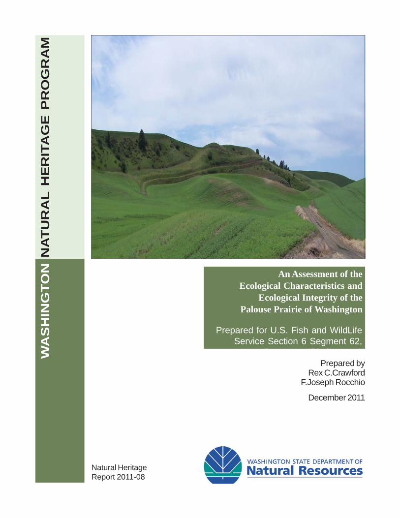
An Assessment of theEcological Characteristics and
Ecological Integrity of thePalouse Prairie of Washington
Natural HeritageReport 2011-08
Prepared byRex C.Crawford
F.Joseph Rocchio
December 2011
WA
SH
ING
TO
N N
AT
UR
AL
HE
RIT
AG
E P
RO
GR
AM
Prepared for U.S. Fish and WildLifeService Section 6 Segment 62,Somewhere, WA (this is 14 pt.)

An Assessment of the Ecological Characteristics
and Ecological Integrity of the Palouse Prairie of
Washington State
Report Prepared for:
U.S. Fish and Wildlife Service
Section 6
3E2 Segment 62
Prepared by:
Rex C. Crawford and F. Joseph Rocchio
Washington Natural Heritage Program
Washington Department of Natural Resources
Olympia, Washington 98504-7014
December 28, 2011

i
Table of Contents
List of Tables ......................................................................................................................................... i
List of Figures .......................................................................................................................................ii
1.0 Introduction ..................................................................................................................................... 3
1.1 Project Objective ........................................................................................................................ 3
1.2 Vegetation .............................................................................................................................. 3
2.0 Methods ........................................................................................................................................... 3
2.1 Field Methods ............................................................................................................................. 3
2.3.1 Classification ........................................................................................................................ 4
2.3.2 Ecological and Biological Characteristics ........................................................................... 5
2.3.3 Ecological Integrity Assessments ....................................................................................... 5
3.0 Results and Discussion ................................................................................................................... 8
3.1 Ecological Characteristics of Palouse Prairie Fragments ......................................................... 8
3.1.1 Classification ........................................................................................................................ 8
3.1.2 Overall Ecological Condition............................................................................................. 10
3.2 Biodiversity Significance .......................................................................................................... 26
3.2.1 Elements of Conservation Concern ................................................................................. 27
Literature Cited ................................................................................................................................... 28
Appendices .......................................................................................................................................... 31
List of Tables Table 1. Summary of scores and ranks for metrics, factors, and the overall ecological integrity
for a level 2 rapid field-based assessment vegetation, hydrology and soils are key ecological
attributes (KEA) within the condition rank factor. ............................................................................. 7
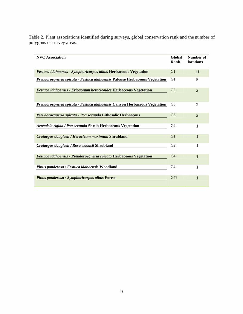
Table 2. Plant associations identified during surveys, global conservation rank and the number of
polygons or survey areas. ..................................................................................................................... 9
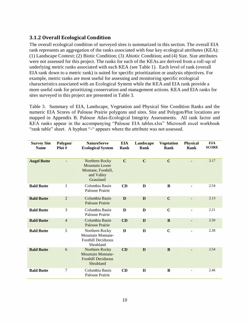
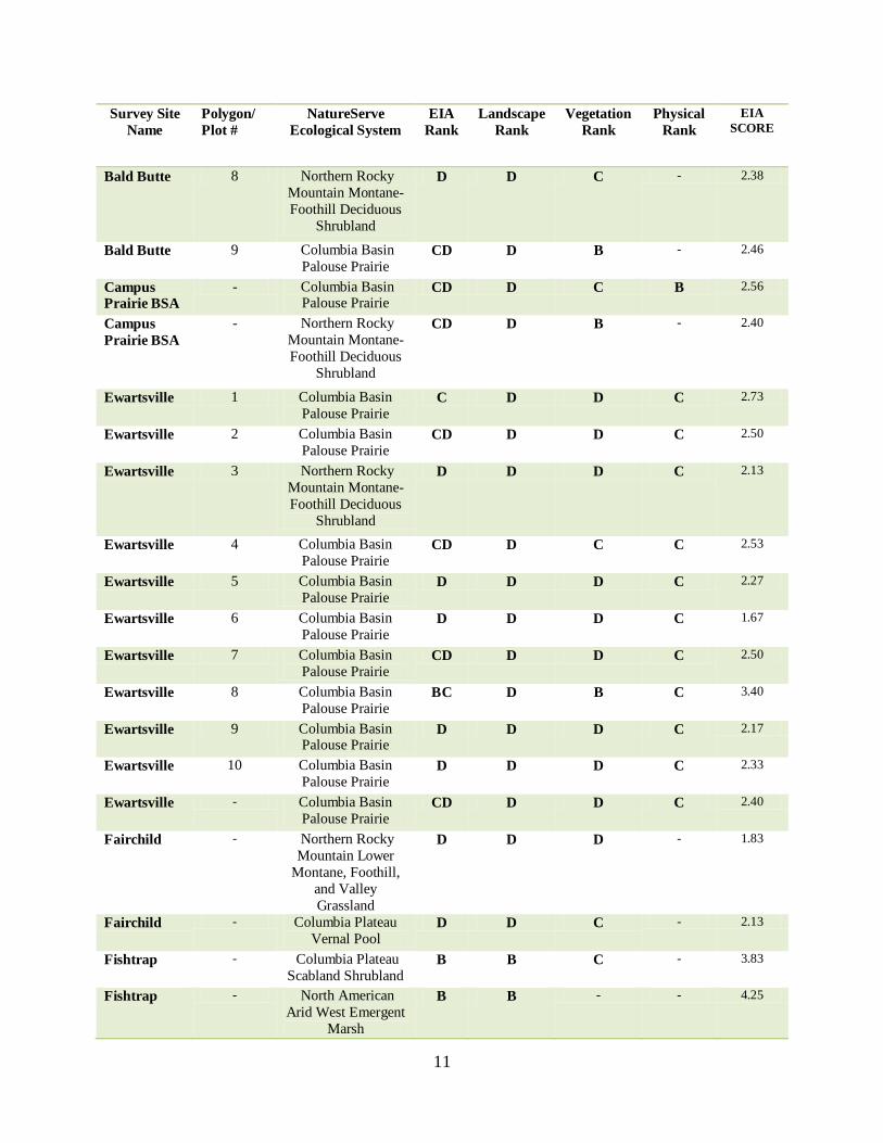
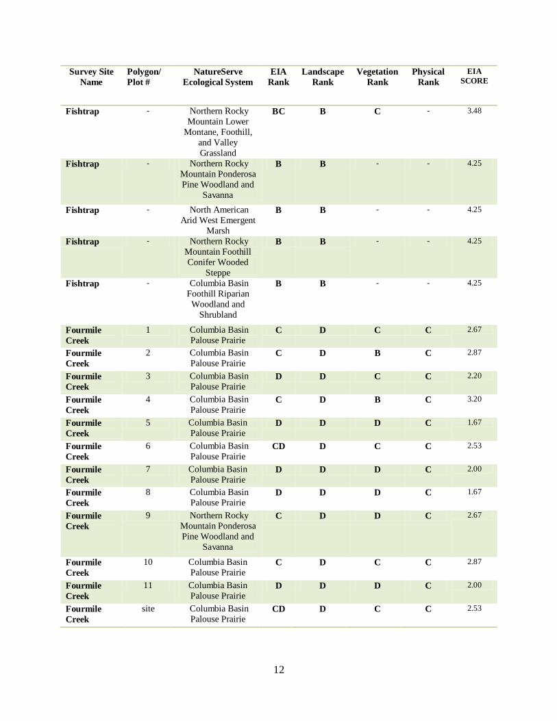
Table 3. Summary of EIA, Landscape, Vegetation and Physical Site Condition Ranks and the
numeric EIA Scores of Palouse Prairie polygons and sites. Site and Polygon/Plot locations are
mapped in Appendix B. Palouse Atlas-Ecological Integrity Assessments. All rank factor and
KEA ranks appear in the accompanying “Palouse EIA tables.xlsx” Microsoft excel workbook
“rank table” sheet. A hyphen “-“ appears where the attribute was not assessed. .......................... 10
ii
Table 4. EIA rank of predominant ecological system in polygons/sites for highest ranking sites.
EIA rank is the average of factors with ranks, thus areas with only a single ranked attribute may
not reflect the overall integrity of a location; see Fishtrap below where only a single attribute,
Landscape Rank, generated the EIA rank. ........................................................................................ 18
Table 5. Palouse survey locations with Vegetation Ranks A through BC. .................................... 21
Table 6. Palouse Atlas sites with grassland or prairie polygons with an EIA rank or vegetation
condition rank of A thourgh BC. Numeric values are the number of sites in that cell with lower
ranked grassland polygons. Sites with more than one grassland polygon can occur in more than
one rank cell. ....................................................................................................................................... 23
Table 7. Summary of overall stressor values for representative ecological systems at 27 Palouse
Atlas sites. VH = very high impact; H = high impact; M = moderate impact; L = low impact. “*”
indicates sites selected to begin initial conservation evaluation and planning in previous section.
See Appendix A for stressor definitions. .......................................................................................... 24
Table 8. Frequency of stressors rated at Palouse Atlas sites. “Stressor Table” sheet in the
accompanying “Palouse EIA tables.xlsx” Microsoft excel workbook lists all stressors and
ratings. ................................................................................................................................................. 26
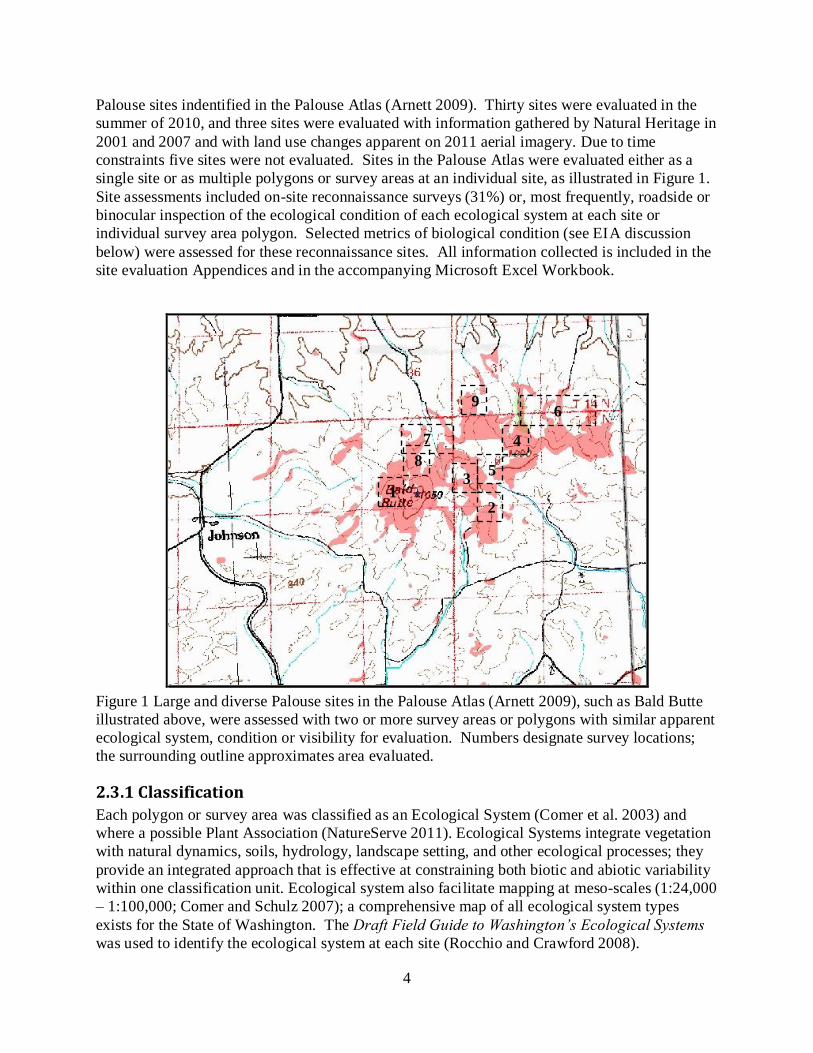
List of Figures Figure 1 Large and diverse Palouse sites in the Palouse Atlas (Arnett 2009), such as Bald Butte
illustrated above, were assessed with two or more survey areas or polygons with similar apparent
ecological system, condition or visibility for evaluation. Numbers designate survey locations;
the surrounding outline approximates area evaluated. ....................................................................... 4
3
1.0 Introduction
1.1 Project Objective In order to prioritize conservation actions among the Palouse Prairie fragments in Washington
State, the Washington Natural Heritage Program collected information pertaining to the
biodiversity and current ecological conditions associated with sites in the Palouse Atlas (Arnett
2009). This knowledge will inform the development of strategies to conserve the biodiversity
supported by these ecological systems. It will also help to stratify Palouse sites for further
evaluation and conservation action.
The project assessment area included Palouse sites identified in the Palouse Atlas (Arnett 2009).
Thirty of 38 sites were evaluated in the summer of 2010. An additional three sites were evaluated
in with 2001 and 2007 information and by land use changes apparent on 2011 aerial imagery.
The following information was collected at each site: (1) identification of ecological systems
present, using NatureServe’s Ecological System’s Classification (Comer et al. 2003); (2) data on
ecological condition by conducting a rapid assessment (walking or with binoculars) of ecological
condition using the Ecological Integrity Assessment method (Faber-Langendoen et al. 2006,
2008a, 2009a, WNHP 2010); and (3) a description of the biological and ecological
characteristics including a stressors evaluation.
1.2 Vegetation
Dryland agriculture and rangeland are the primary land uses in the project area and occupy over
94% of the landscape (Black et al. 1998). In areas not suitable for dryland agriculture, livestock
grazing is the most common land use. The natural and semi-natural uplands in the project area
are dominated by shrubland and grassland vegetation. According to NatureServe’s Ecological
System classification, the matrix of the upland vegetation would be considered Columbia Basin
Palouse Prairie with a transition into the Northern Rocky Mountain Lower Montane, Foothill,
and Valley Grassland along the forest edges, and the Columbia Basin Foothill and Canyon Dry
Grassland on steep dry aspects along the Snake River and its larger tributaries. These ecological
systems are bunchgrass grasslands dominated by cool-season perennial grasses such as Idaho
fescue (Festuca idahoensis) and bluebunch wheatgrass (Pseudoroegneria spicata). Also
common in the uplands are the Northern Rocky Mountain Montane-Foothill Deciduous
Shrubland ecological system, often dominated by hawthorn (Crataegus spp.), rose (Rosa spp.)
and snowberry (Symphoricarpos spp.) and the Columbia Plateau Scabland Shrublands, which are
lithosolic communities dominated by rigid sagebrush (Artemisia rigida), various buckwheats
(Eriogonum spp.), and Sandberg’s bluegrass (Poa sandbergii). The predominant upland
grassland plant associations are Idaho fescue/common snowberry, Idaho fescue-bluebunch
wheatgrass and bluebunch wheatgrass-Sandberg’s bluegrass.
2.0 Methods 2.1 Field Methods The following section provides an overview of methods and a description of the types of data
collected at each of the randomly selected polygons. The field forms are included in Appendix
A. Rex Crawford and Joe Rocchio, ecologists with the Washington Natural Heritage Program,
each surveyed approximately one-half of the sites evaluated. The assessment included 33 of 38
4
Palouse sites indentified in the Palouse Atlas (Arnett 2009). Thirty sites were evaluated in the
summer of 2010, and three sites were evaluated with information gathered by Natural Heritage in
2001 and 2007 and with land use changes apparent on 2011 aerial imagery. Due to time
constraints five sites were not evaluated. Sites in the Palouse Atlas were evaluated either as a
single site or as multiple polygons or survey areas at an individual site, as illustrated in Figure 1.
Site assessments included on-site reconnaissance surveys (31%) or, most frequently, roadside or
binocular inspection of the ecological condition of each ecological system at each site or
individual survey area polygon. Selected metrics of biological condition (see EIA discussion
below) were assessed for these reconnaissance sites. All information collected is included in the
site evaluation Appendices and in the accompanying Microsoft Excel Workbook.
Figure 1 Large and diverse Palouse sites in the Palouse Atlas (Arnett 2009), such as Bald Butte
illustrated above, were assessed with two or more survey areas or polygons with similar apparent
ecological system, condition or visibility for evaluation. Numbers designate survey locations;
the surrounding outline approximates area evaluated.
2.3.1 Classification
Each polygon or survey area was classified as an Ecological System (Comer et al. 2003) and
where a possible Plant Association (NatureServe 2011). Ecological Systems integrate vegetation
with natural dynamics, soils, hydrology, landscape setting, and other ecological processes; they
provide an integrated approach that is effective at constraining both biotic and abiotic variability
within one classification unit. Ecological system also facilitate mapping at meso-scales (1:24,000
– 1:100,000; Comer and Schulz 2007); a comprehensive map of all ecological system types
exists for the State of Washington. The Draft Field Guide to Washington’s Ecological Systems
was used to identify the ecological system at each site (Rocchio and Crawford 2008).
9
8
7
6
5
4
2
3 1
5
The plant association is the finest-scale unit of the U.S. National Vegetation Classification
(NVC), supported by the Federal Geographic Data Committee (FGDC 2008), NatureServe
(Faber-Langendoen et al. 2009c), and the Ecological Society of America (Jennings et al. 2009).
The association represents diagnostic species which reflect topo-edaphic, climate, substrates,
hydrology, and/or natural disturbance regimes. The NVC is hierarchical and consists of eight
levels which allows for a link to NatureServe’s Ecological Systems classification (described
above) and meets several important needs for conservation and resource management. It
provides a multi-level, ecologically based framework that allow users to address conservation
and management concerns at appropriate scales, a characterization of ecosystem patterns across
the entire landscape or watershed, information on the relative rarity of types (associations has
been assessed for conservation status), and relationships to other classification systems explicitly
linked to the NVC types (e.g. the Ecological System classification) a federal standard for all
federal agencies, facilitating sharing of information on ecosystem types (FGDC 2008).
2.3.2 Ecological and Biological Characteristics
At each Palouse Atlas site surveyed, the following ecological attributes were documented or
recorded:
Classification (see above)
Location
General descriptive information
Partial Plant species list
Ecological condition (using Ecological Integrity Assessment; see below)
List of stressors, following NatureServe methodology (Master et al. 2009)
2.3.3 Ecological Integrity Assessments
NatureServe and the Natural Heritage Network have developed an approach for assessing
ecological condition that is scaled both in terms of the ecosystem type being assessed and the
level of information required to conduct the assessment. This method is called the Ecological
Integrity Assessment (Faber-Langendoen et al. 2006, 2008, 2009a, 2009b) and is being
implemented at a variety of small- and large-scale projects (Rocchio and Crawford 2009, Lemly
and Rocchio 2009, Faber-Langendoen et al. 2009b, Tierney et al. 2009, Vance et al. In
Progress). Such indicator-based (ecological endpoints) approaches to assessing and reporting on
ecological integrity (Harwell et al. 1999, Young and Sanzone 2002) are being used by numerous
organizations to assist with regulatory decisions (Mack 2004), to set mitigation performance
standards (Mack 2004, Faber-Langendoen et al. 2006, 2008a), and to set conservation priorities
(Faber-Langendoen et al. 2008b).
The Ecological Integrity Assessment method (EIA) aims to measure the current ecological
integrity of a site through a standardized and repeatable assessment of conditions associated with
the structure, composition, and ecological processes of a particular ecological system. These
6
conditions are then compared or ranked according to conditions expected in those sites operating
within the bounds of their natural range of variation. The purpose of assigning an index of
ecological integrity is to provide a succinct assessment of the current status of the composition,
structure and function of occurrences of a particular ecosystem type and to give a general sense
of conservation value, management effects, restoration success, etc. As such, the objectives of an
EIA include: (1) to assess ecological integrity on a fixed, objective scale; (2) to compare
ecological integrity of various occurrences of the same ecological system; (3) to determine the
best examples of a individual ecological system types and to support selection of sites for
conservation priority; (4) to inform decisions on monitoring individual ecological attributes of a
particular occurrence; and (5) to provide an aggregated index of integrity to interpret monitoring
data, including tracking the status of ecological integrity over time. The EIA aims to standardize
expert opinion and existing data up front so that a single, qualified ecologist could apply the EIA
in a rapid manner to get an estimate of a site’s ecological integrity. The EIA can improve an
understanding of current ecological conditions which can lead to more effective and efficient use
of available resources for ecosystem protection, management, and restoration efforts.
For this project, EIAs developed by the Washington Natural Heritage Program (WNHP 2010)
were used to rapidly assess the ecological integrity of Ecological Systems at each Palouse site.
The metrics and rating criteria used in the EIA assessment are found in the field forms presented
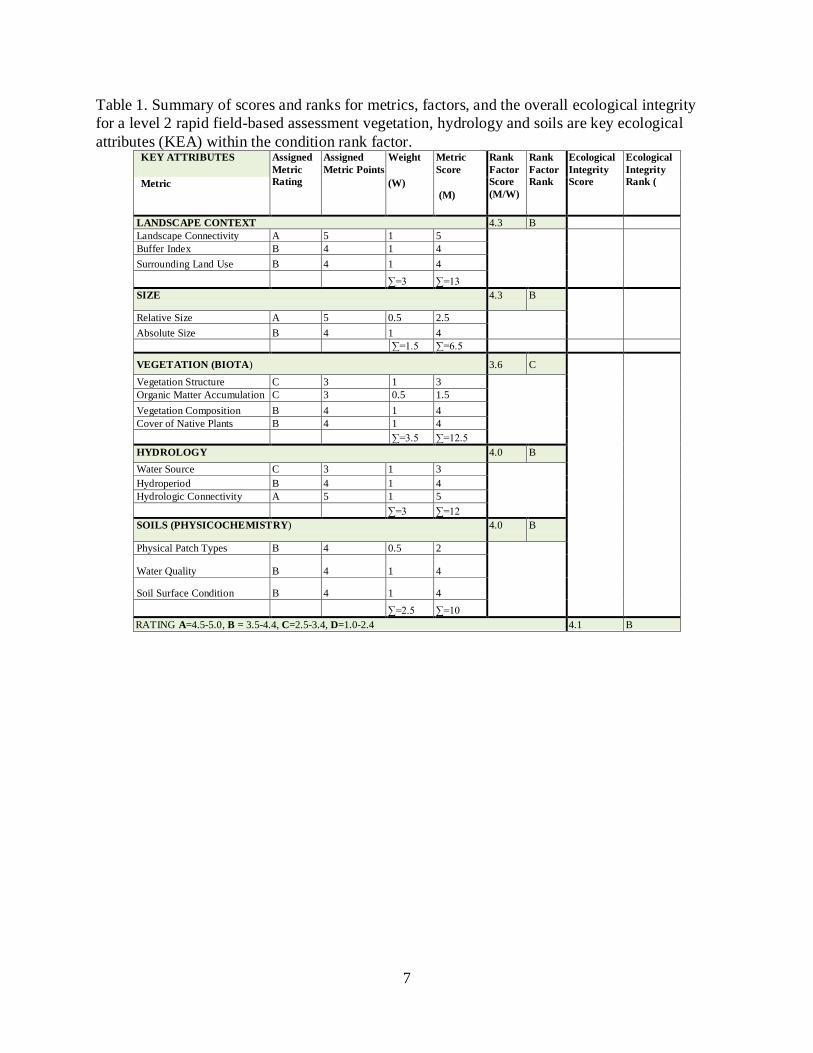
in Appendix A. Letter rankings for each metric, such as “Bunchgrass Cover” were given numeric
scores (arranged from high to low integrity: A=5.0, B=4.0, C=3.0, D=1.0) which were then used
to aggregate metric and Key Ecological Attribute (KEA), such as Landscape Context, scores into
higher level ranks through simple, weight-based algorithms (Table 1). For example, metrics
associated with each KEA were summed and divided by the total number of metrics (i.e., metrics
were given equal weight in this project). KEA scores are averaged to arrive at an overall
Ecological Integrity Assessment Score. This score was then converted back into a letter ranking.
7
Table 1. Summary of scores and ranks for metrics, factors, and the overall ecological integrity
for a level 2 rapid field-based assessment vegetation, hydrology and soils are key ecological
attributes (KEA) within the condition rank factor. KEY ATTRIBUTES Assigned
Metric
Rating
Assigned
Metric Points
Weight
(W)
Metric
Score
(M)
Rank
Factor
Score
(M/W)
Rank
Factor
Rank
Ecological
Integrity
Score
Ecological
Integrity
Rank ( Metric
LANDSCAPE CONTEXT 4.3 B
Landscape Connectivity A 5 1 5
Buffer Index B 4 1 4
Surrounding Land Use B 4 1 4
∑=3 ∑=13
SIZE 4.3 B
Relative Size A 5 0.5 2.5
Absolute Size B 4 1 4
∑=1.5 ∑=6.5
VEGETATION (BIOTA) 3.6 C
Vegetation Structure C 3 1 3
Organic Matter Accumulation C 3 0.5 1.5
Vegetation Composition B 4 1 4
Cover of Native Plants B 4 1 4
∑=3.5 ∑=12.5
HYDROLOGY 4.0 B
Water Source C 3 1 3
Hydroperiod B 4 1 4
Hydrologic Connectivity A 5 1 5
∑=3 ∑=12
SOILS (PHYSICOCHEMISTRY) 4.0 B
Physical Patch Types B 4 0.5 2
Water Quality B 4 1 4
Soil Surface Condition B 4 1 4
∑=2.5 ∑=10
RATING A=4.5-5.0, B = 3.5-4.4, C=2.5-3.4, D=1.0-2.4 4.1 B
8
3.0 Results and Discussion
3.1 Ecological Characteristics of Palouse Prairie Fragments A summary of the ecological characteristics of each Palouse site surveyed is presented in
Appendix C. All of the data collected for this project are found in the accompanying “Palouse
EIA tables.xlsx” Microsoft Excel workbook. Some of the key ecological characteristics are
discussed below. Thirty of the 38 sites in the Palouse Atlas were visited in 2010; an additional
evaluation of 3 sites using previous information and 2011 imagery are included. A total of 139
polygons or survey areas were evaluated.
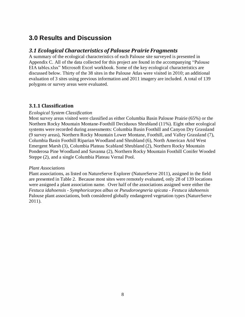
3.1.1 Classification
Ecological System Classification
Most survey areas visited were classified as either Columbia Basin Palouse Prairie (65%) or the
Northern Rocky Mountain Montane-Foothill Deciduous Shrubland (11%). Eight other ecological
systems were recorded during assessments: Columbia Basin Foothill and Canyon Dry Grassland
(9 survey areas), Northern Rocky Mountain Lower Montane, Foothill, and Valley Grassland (7),
Columbia Basin Foothill Riparian Woodland and Shrubland (6), North American Arid West
Emergent Marsh (3), Columbia Plateau Scabland Shrubland (2), Northern Rocky Mountain
Ponderosa Pine Woodland and Savanna (2), Northern Rocky Mountain Foothill Conifer Wooded
Steppe (2), and a single Columbia Plateau Vernal Pool.
Plant Associations
Plant associations, as listed on NatureServe Explorer (NatureServe 2011), assigned in the field
are presented in Table 2. Because most sites were remotely evaluated, only 28 of 139 locations
were assigned a plant association name. Over half of the associations assigned were either the
Festuca idahoensis - Symphoricarpos albus or Pseudoroegneria spicata - Festuca idahoensis
Palouse plant associations, both considered globally endangered vegetation types (NatureServe
2011).
9
Table 2. Plant associations identified during surveys, global conservation rank and the number of
polygons or survey areas.
NVC Association Global
Rank
Number of
locations
Festuca idahoensis - Symphoricarpos albus Herbaceous Vegetation G1 11
Pseudoroegneria spicata - Festuca idahoensis Palouse Herbaceous Vegetation
G1 5
Festuca idahoensis - Eriogonum heracleoides Herbaceous Vegetation
G2 2
Pseudoroegneria spicata - Festuca idahoensis Canyon Herbaceous Vegetation
G3 2
Pseudoroegneria spicata - Poa secunda Lithosolic Herbaceous
G3 2
Artemisia rigida / Poa secunda Shrub Herbaceous Vegetation
G4 1
Crataegus douglasii / Heracleum maximum Shrubland G1 1
Crataegus douglasii / Rosa woodsii Shrubland
G2 1
Festuca idahoensis - Pseudoroegneria spicata Herbaceous Vegetation
G4 1
Pinus ponderosa / Festuca idahoensis Woodland
G4 1
Pinus ponderosa / Symphoricarpos albus Forest
G4? 1
10
3.1.2 Overall Ecological Condition
The overall ecological condition of surveyed sites is summarized in this section. The overall EIA
rank represents an aggregation of the ranks associated with four key ecological attributes (KEA):
(1) Landscape Context; (2) Biotic Condition; (3) Abiotic Condition; and (4) Size. Size attributes
were not assessed for this project. The ranks for each of the KEAs are derived from a roll-up of
underlying metric ranks associated with each KEA (see Table 1). Each level of rank (overall
EIA rank down to a metric rank) is suited for specific prioritization or analysis objectives. For
example, metric ranks are most useful for assessing and monitoring specific ecological
characteristics associated with an Ecological System while the KEA and EIA rank provide a
more useful rank for prioritizing conservation and management actions. KEA and EIA ranks for
sites surveyed in this project are presented in Table 3.
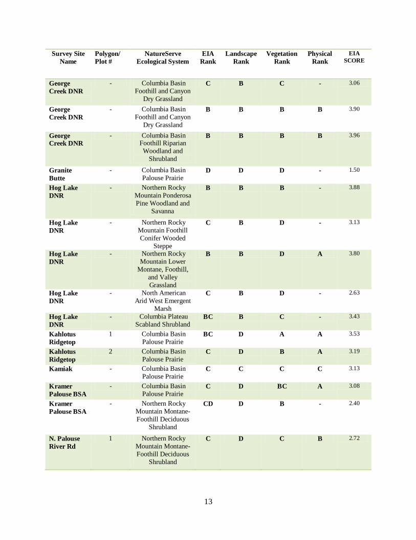
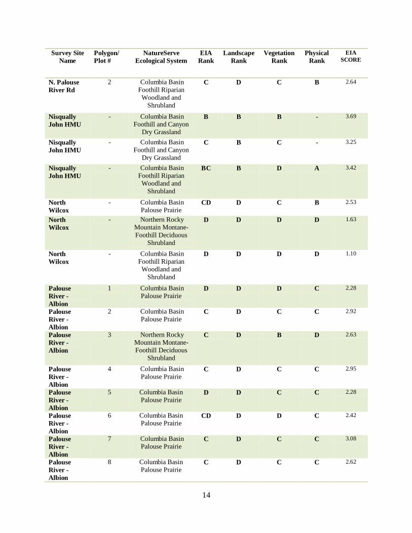
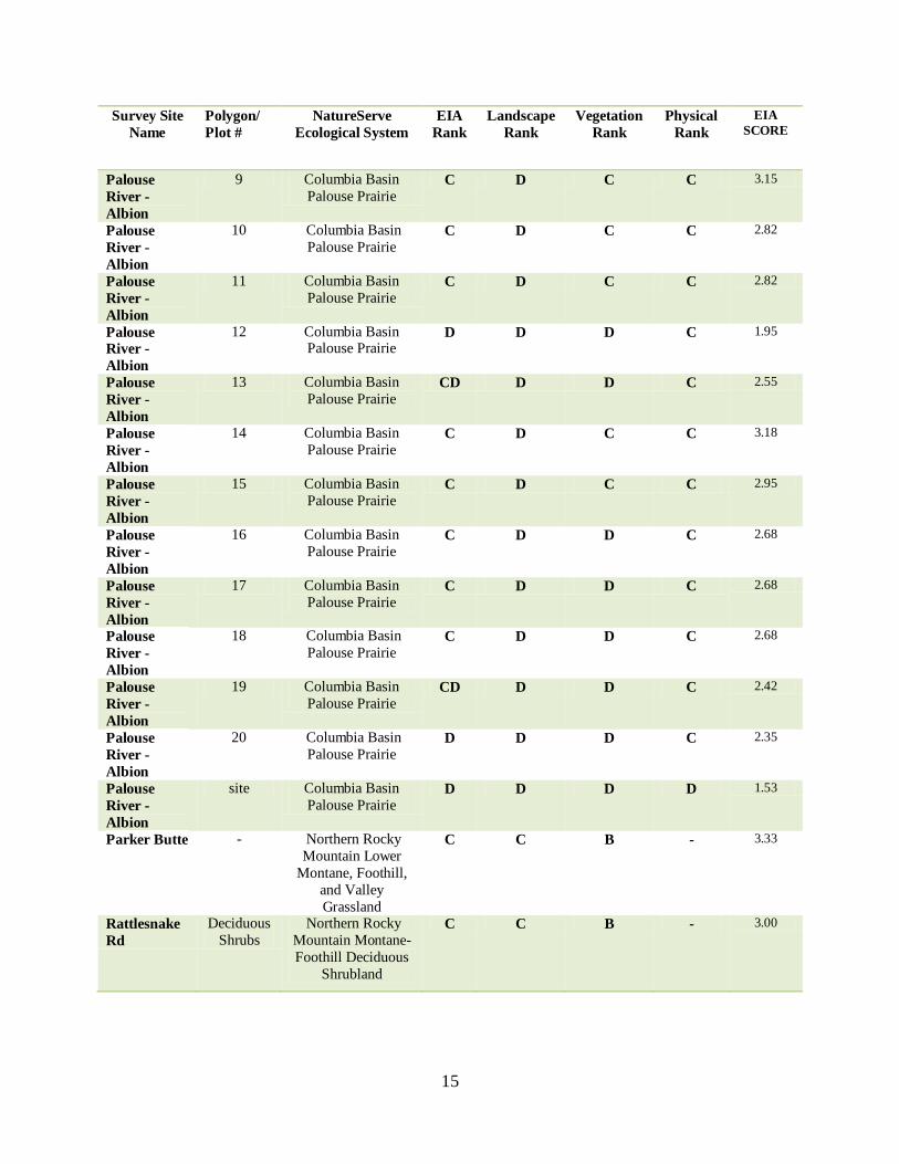
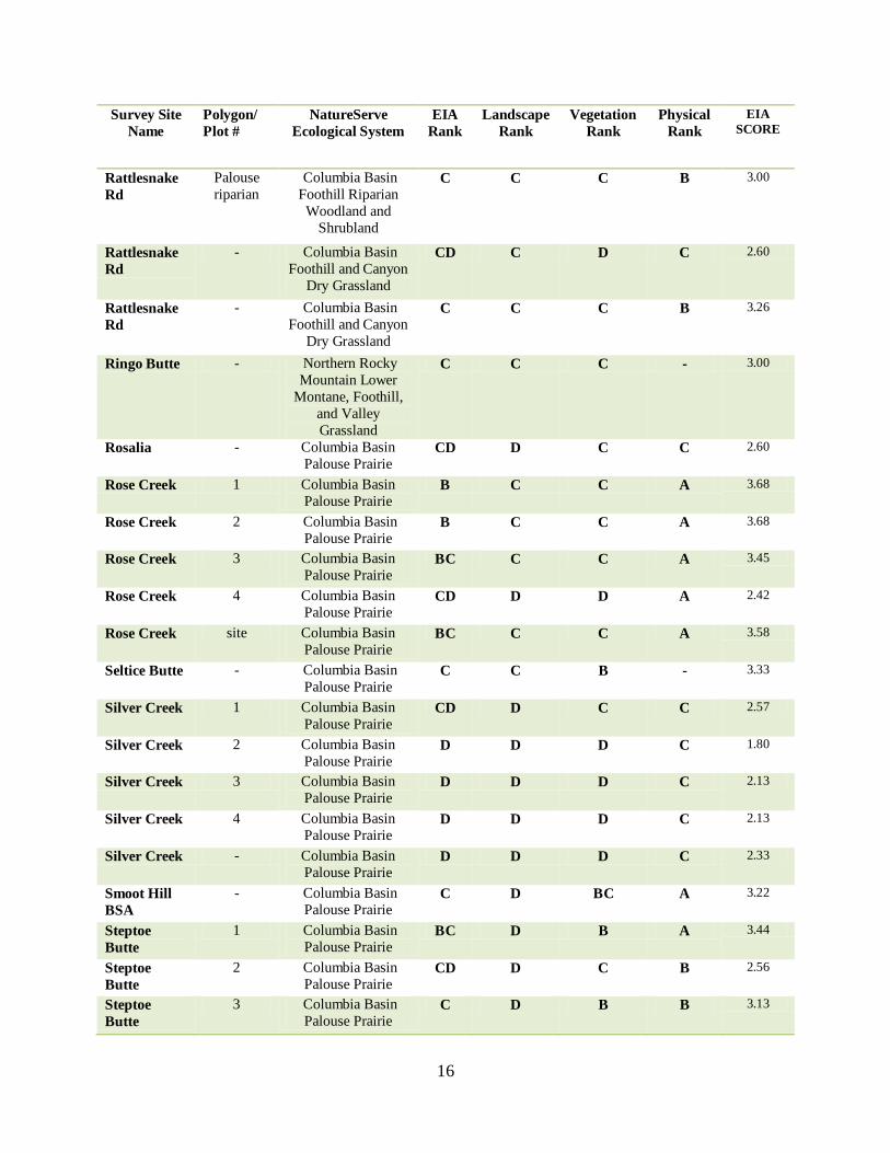
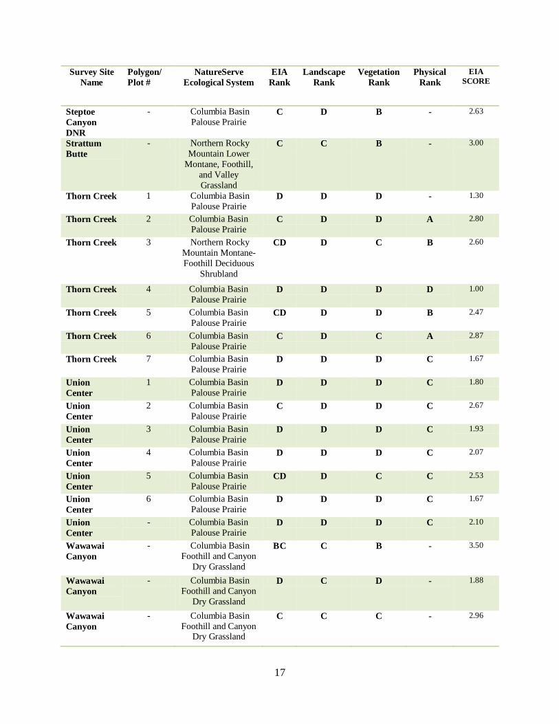
Table 3. Summary of EIA, Landscape, Vegetation and Physical Site Condition Ranks and the
numeric EIA Scores of Palouse Prairie polygons and sites. Site and Polygon/Plot locations are
mapped in Appendix B. Palouse Atlas-Ecological Integrity Assessments. All rank factor and
KEA ranks appear in the accompanying “Palouse EIA tables.xlsx” Microsoft excel workbook
“rank table” sheet. A hyphen “-“ appears where the attribute was not assessed.
Survey Site
Name
Polygon/
Plot #
NatureServe
Ecological System
EIA
Rank
Landscape
Rank
Vegetation
Rank
Physical
Rank
EIA
SCORE
Angel Butte - Northern Rocky
Mountain Lower
Montane, Foothill,
and Valley
Grassland
C C C - 3.17
Bald Butte 1 Columbia Basin
Palouse Prairie CD D B - 2.54
Bald Butte 2 Columbia Basin
Palouse Prairie D D C - 2.13
Bald Butte 3 Columbia Basin
Palouse Prairie D D C - 2.21
Bald Butte 4 Columbia Basin
Palouse Prairie CD D B - 2.50
Bald Butte 5 Northern Rocky
Mountain Montane-
Foothill Deciduous
Shrubland
D D C - 2.38
Bald Butte 6 Northern Rocky
Mountain Montane-
Foothill Deciduous
Shrubland
CD D B - 2.54
Bald Butte 7 Columbia Basin
Palouse Prairie CD D B - 2.46
11
Survey Site
Name
Polygon/
Plot #
NatureServe
Ecological System
EIA
Rank
Landscape
Rank
Vegetation
Rank
Physical
Rank
EIA
SCORE
Bald Butte 8 Northern Rocky
Mountain Montane-
Foothill Deciduous
Shrubland
D D C - 2.38
Bald Butte 9 Columbia Basin
Palouse Prairie CD D B - 2.46
Campus Prairie BSA
- Columbia Basin Palouse Prairie
CD D C B 2.56
Campus
Prairie BSA
- Northern Rocky
Mountain Montane-
Foothill Deciduous
Shrubland
CD D B - 2.40
Ewartsville 1 Columbia Basin
Palouse Prairie C D D C 2.73
Ewartsville 2 Columbia Basin
Palouse Prairie CD D D C 2.50
Ewartsville 3 Northern Rocky
Mountain Montane-
Foothill Deciduous
Shrubland
D D D C 2.13
Ewartsville 4 Columbia Basin
Palouse Prairie CD D C C 2.53
Ewartsville 5 Columbia Basin
Palouse Prairie D D D C 2.27
Ewartsville 6 Columbia Basin
Palouse Prairie D D D C 1.67
Ewartsville 7 Columbia Basin
Palouse Prairie CD D D C 2.50
Ewartsville 8 Columbia Basin
Palouse Prairie BC D B C 3.40
Ewartsville 9 Columbia Basin Palouse Prairie
D D D C 2.17
Ewartsville 10 Columbia Basin
Palouse Prairie D D D C 2.33
Ewartsville - Columbia Basin
Palouse Prairie CD D D C 2.40
Fairchild - Northern Rocky
Mountain Lower
Montane, Foothill,
and Valley
Grassland
D D D - 1.83
Fairchild - Columbia Plateau
Vernal Pool D D C - 2.13
Fishtrap - Columbia Plateau
Scabland Shrubland B B C - 3.83
Fishtrap - North American
Arid West Emergent
Marsh
B B - - 4.25
12
Survey Site
Name
Polygon/
Plot #
NatureServe
Ecological System
EIA
Rank
Landscape
Rank
Vegetation
Rank
Physical
Rank
EIA
SCORE
Fishtrap - Northern Rocky
Mountain Lower
Montane, Foothill,
and Valley
Grassland
BC B C - 3.48
Fishtrap - Northern Rocky
Mountain Ponderosa
Pine Woodland and
Savanna
B B - - 4.25
Fishtrap - North American
Arid West Emergent
Marsh
B B - - 4.25
Fishtrap - Northern Rocky
Mountain Foothill
Conifer Wooded
Steppe
B B - - 4.25
Fishtrap - Columbia Basin
Foothill Riparian
Woodland and
Shrubland
B B - - 4.25
Fourmile
Creek
1 Columbia Basin
Palouse Prairie C D C C 2.67
Fourmile
Creek
2 Columbia Basin
Palouse Prairie C D B C 2.87
Fourmile
Creek
3 Columbia Basin
Palouse Prairie D D C C 2.20
Fourmile
Creek
4 Columbia Basin
Palouse Prairie C D B C 3.20
Fourmile
Creek
5 Columbia Basin
Palouse Prairie D D D C 1.67
Fourmile
Creek
6 Columbia Basin
Palouse Prairie CD D C C 2.53
Fourmile
Creek
7 Columbia Basin
Palouse Prairie D D D C 2.00
Fourmile
Creek
8 Columbia Basin
Palouse Prairie D D D C 1.67
Fourmile
Creek
9 Northern Rocky
Mountain Ponderosa
Pine Woodland and
Savanna
C D D C 2.67
Fourmile
Creek
10 Columbia Basin
Palouse Prairie C D C C 2.87
Fourmile
Creek
11 Columbia Basin
Palouse Prairie D D D C 2.00
Fourmile
Creek
site Columbia Basin
Palouse Prairie CD D C C 2.53
13
Survey Site
Name
Polygon/
Plot #
NatureServe
Ecological System
EIA
Rank
Landscape
Rank
Vegetation
Rank
Physical
Rank
EIA
SCORE
George
Creek DNR
- Columbia Basin
Foothill and Canyon
Dry Grassland
C B C - 3.06
George
Creek DNR
- Columbia Basin
Foothill and Canyon
Dry Grassland
B B B B 3.90
George Creek DNR
- Columbia Basin Foothill Riparian
Woodland and
Shrubland
B B B B 3.96
Granite
Butte
- Columbia Basin
Palouse Prairie D D D - 1.50
Hog Lake
DNR
- Northern Rocky
Mountain Ponderosa
Pine Woodland and
Savanna
B B B - 3.88
Hog Lake
DNR
- Northern Rocky
Mountain Foothill
Conifer Wooded
Steppe
C B D - 3.13
Hog Lake
DNR
- Northern Rocky
Mountain Lower
Montane, Foothill,
and Valley
Grassland
B B D A 3.80
Hog Lake
DNR
- North American
Arid West Emergent
Marsh
C B D - 2.63
Hog Lake
DNR
- Columbia Plateau
Scabland Shrubland BC B C - 3.43
Kahlotus
Ridgetop
1 Columbia Basin
Palouse Prairie BC D A A 3.53
Kahlotus
Ridgetop
2 Columbia Basin
Palouse Prairie C D B A 3.19
Kamiak - Columbia Basin
Palouse Prairie C C C C 3.13
Kramer
Palouse BSA
- Columbia Basin
Palouse Prairie C D BC A 3.08
Kramer
Palouse BSA
- Northern Rocky
Mountain Montane-
Foothill Deciduous
Shrubland
CD D B - 2.40
N. Palouse
River Rd
1 Northern Rocky
Mountain Montane-
Foothill Deciduous
Shrubland
C D C B 2.72
14
Survey Site
Name
Polygon/
Plot #
NatureServe
Ecological System
EIA
Rank
Landscape
Rank
Vegetation
Rank
Physical
Rank
EIA
SCORE
N. Palouse
River Rd
2 Columbia Basin
Foothill Riparian
Woodland and
Shrubland
C D C B 2.64
Nisqually
John HMU
- Columbia Basin
Foothill and Canyon
Dry Grassland
B B B - 3.69
Nisqually
John HMU
- Columbia Basin
Foothill and Canyon
Dry Grassland
C B C - 3.25
Nisqually
John HMU
- Columbia Basin
Foothill Riparian
Woodland and
Shrubland
BC B D A 3.42
North
Wilcox
- Columbia Basin
Palouse Prairie CD D C B 2.53
North
Wilcox
- Northern Rocky
Mountain Montane-
Foothill Deciduous
Shrubland
D D D D 1.63
North
Wilcox
- Columbia Basin
Foothill Riparian
Woodland and
Shrubland
D D D D 1.10
Palouse
River -
Albion
1 Columbia Basin
Palouse Prairie D D D C 2.28
Palouse
River -
Albion
2 Columbia Basin
Palouse Prairie C D C C 2.92
Palouse
River -
Albion
3 Northern Rocky
Mountain Montane-
Foothill Deciduous
Shrubland
C D B D 2.63
Palouse
River -
Albion
4 Columbia Basin
Palouse Prairie C D C C 2.95
Palouse
River -
Albion
5 Columbia Basin
Palouse Prairie D D C C 2.28
Palouse
River -
Albion
6 Columbia Basin
Palouse Prairie CD D D C 2.42
Palouse
River -
Albion
7 Columbia Basin
Palouse Prairie C D C C 3.08
Palouse
River -
Albion
8 Columbia Basin
Palouse Prairie C D C C 2.62
15
Survey Site
Name
Polygon/
Plot #
NatureServe
Ecological System
EIA
Rank
Landscape
Rank
Vegetation
Rank
Physical
Rank
EIA
SCORE
Palouse
River -
Albion
9 Columbia Basin
Palouse Prairie C D C C 3.15
Palouse
River -
Albion
10 Columbia Basin
Palouse Prairie C D C C 2.82
Palouse
River -
Albion
11 Columbia Basin
Palouse Prairie C D C C 2.82
Palouse River -
Albion
12 Columbia Basin Palouse Prairie
D D D C 1.95
Palouse
River -
Albion
13 Columbia Basin
Palouse Prairie CD D D C 2.55
Palouse
River -
Albion
14 Columbia Basin
Palouse Prairie C D C C 3.18
Palouse
River -
Albion
15 Columbia Basin
Palouse Prairie C D C C 2.95
Palouse
River -
Albion
16 Columbia Basin
Palouse Prairie C D D C 2.68
Palouse
River -
Albion
17 Columbia Basin
Palouse Prairie C D D C 2.68
Palouse
River -
Albion
18 Columbia Basin
Palouse Prairie C D D C 2.68
Palouse
River -
Albion
19 Columbia Basin
Palouse Prairie CD D D C 2.42
Palouse
River -
Albion
20 Columbia Basin
Palouse Prairie D D D C 2.35
Palouse
River -
Albion
site Columbia Basin
Palouse Prairie D D D D 1.53
Parker Butte - Northern Rocky
Mountain Lower
Montane, Foothill,
and Valley
Grassland
C C B - 3.33
Rattlesnake
Rd
Deciduous
Shrubs
Northern Rocky
Mountain Montane-
Foothill Deciduous
Shrubland
C C B - 3.00
16
Survey Site
Name
Polygon/
Plot #
NatureServe
Ecological System
EIA
Rank
Landscape
Rank
Vegetation
Rank
Physical
Rank
EIA
SCORE
Rattlesnake
Rd
Palouse
riparian
Columbia Basin
Foothill Riparian
Woodland and
Shrubland
C C C B 3.00
Rattlesnake
Rd
- Columbia Basin
Foothill and Canyon
Dry Grassland
CD C D C 2.60
Rattlesnake
Rd
- Columbia Basin
Foothill and Canyon
Dry Grassland
C C C B 3.26
Ringo Butte - Northern Rocky
Mountain Lower
Montane, Foothill,
and Valley
Grassland
C C C - 3.00
Rosalia - Columbia Basin
Palouse Prairie CD D C C 2.60
Rose Creek 1 Columbia Basin
Palouse Prairie B C C A 3.68
Rose Creek 2 Columbia Basin
Palouse Prairie B C C A 3.68
Rose Creek 3 Columbia Basin
Palouse Prairie BC C C A 3.45
Rose Creek 4 Columbia Basin
Palouse Prairie CD D D A 2.42
Rose Creek site Columbia Basin
Palouse Prairie BC C C A 3.58
Seltice Butte - Columbia Basin
Palouse Prairie C C B - 3.33
Silver Creek 1 Columbia Basin
Palouse Prairie CD D C C 2.57
Silver Creek 2 Columbia Basin
Palouse Prairie D D D C 1.80
Silver Creek 3 Columbia Basin
Palouse Prairie D D D C 2.13
Silver Creek 4 Columbia Basin
Palouse Prairie D D D C 2.13
Silver Creek - Columbia Basin
Palouse Prairie D D D C 2.33
Smoot Hill
BSA
- Columbia Basin
Palouse Prairie C D BC A 3.22
Steptoe
Butte
1 Columbia Basin
Palouse Prairie BC D B A 3.44
Steptoe
Butte
2 Columbia Basin
Palouse Prairie CD D C B 2.56
Steptoe
Butte
3 Columbia Basin
Palouse Prairie C D B B 3.13
17
Survey Site
Name
Polygon/
Plot #
NatureServe
Ecological System
EIA
Rank
Landscape
Rank
Vegetation
Rank
Physical
Rank
EIA
SCORE
Steptoe
Canyon
DNR
- Columbia Basin
Palouse Prairie C D B - 2.63
Strattum
Butte
- Northern Rocky
Mountain Lower
Montane, Foothill,
and Valley
Grassland
C C B - 3.00
Thorn Creek 1 Columbia Basin
Palouse Prairie D D D - 1.30
Thorn Creek 2 Columbia Basin
Palouse Prairie C D D A 2.80
Thorn Creek 3 Northern Rocky
Mountain Montane-
Foothill Deciduous
Shrubland
CD D C B 2.60
Thorn Creek 4 Columbia Basin
Palouse Prairie D D D D 1.00
Thorn Creek 5 Columbia Basin
Palouse Prairie CD D D B 2.47
Thorn Creek 6 Columbia Basin
Palouse Prairie C D C A 2.87
Thorn Creek 7 Columbia Basin
Palouse Prairie D D D C 1.67
Union
Center
1 Columbia Basin
Palouse Prairie D D D C 1.80
Union
Center
2 Columbia Basin
Palouse Prairie C D D C 2.67
Union
Center
3 Columbia Basin
Palouse Prairie D D D C 1.93
Union
Center
4 Columbia Basin
Palouse Prairie D D D C 2.07
Union
Center
5 Columbia Basin
Palouse Prairie CD D C C 2.53
Union
Center
6 Columbia Basin
Palouse Prairie D D D C 1.67
Union
Center
- Columbia Basin
Palouse Prairie D D D C 2.10
Wawawai
Canyon
- Columbia Basin
Foothill and Canyon
Dry Grassland
BC C B - 3.50
Wawawai
Canyon
- Columbia Basin
Foothill and Canyon
Dry Grassland
D C D - 1.88
Wawawai
Canyon
- Columbia Basin
Foothill and Canyon Dry Grassland
C C C - 2.96
18
Survey Site
Name
Polygon/
Plot #
NatureServe
Ecological System
EIA
Rank
Landscape
Rank
Vegetation
Rank
Physical
Rank
EIA
SCORE
Wilcox & SE 1 Columbia Basin
Palouse Prairie D D D D 1.50
Wilcox & SE 1 Northern Rocky
Mountain Montane-
Foothill Deciduous
Shrubland
D D C D 1.75
Wilcox & SE 2 Columbia Basin Palouse Prairie
CD D B D 2.60
Wilcox & SE 2 Northern Rocky
Mountain Montane-
Foothill Deciduous
Shrubland
D D B D 2.38
Wilcox & SE 3 Columbia Basin
Palouse Prairie D D C D 1.95
Wilcox & SE 3 Northern Rocky
Mountain Montane-
Foothill Deciduous
Shrubland
C D A D 3.00
Wilcox & SE - Columbia Basin
Palouse Prairie CD D C C 2.53
West
Kamiak
1 Columbia Basin
Palouse Prairie C D C A 3.07
West
Kamiak
2 Northern Rocky
Mountain Montane-
Foothill Deciduous
Shrubland
C D B A 3.22
West
Kamiak
3 Columbia Basin
Palouse Prairie C D C A 3.00
West
Kamiak
site Columbia Basin
Palouse Prairie C D C A 3.19
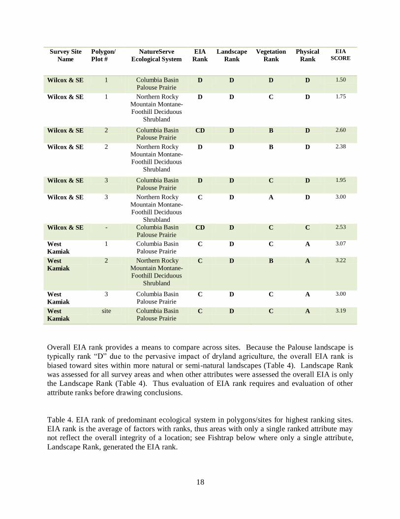
Overall EIA rank provides a means to compare across sites. Because the Palouse landscape is
typically rank “D” due to the pervasive impact of dryland agriculture, the overall EIA rank is
biased toward sites within more natural or semi-natural landscapes (Table 4). Landscape Rank
was assessed for all survey areas and when other attributes were assessed the overall EIA is only
the Landscape Rank (Table 4). Thus evaluation of EIA rank requires and evaluation of other
attribute ranks before drawing conclusions.
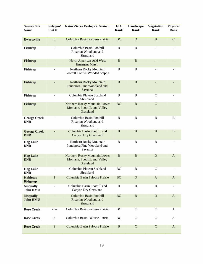
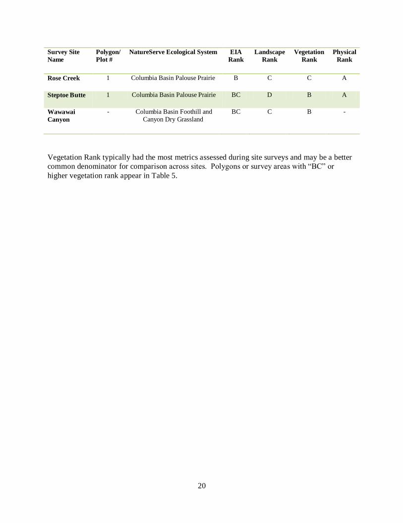
Table 4. EIA rank of predominant ecological system in polygons/sites for highest ranking sites.
EIA rank is the average of factors with ranks, thus areas with only a single ranked attribute may
not reflect the overall integrity of a location; see Fishtrap below where only a single attribute,
Landscape Rank, generated the EIA rank.
19
Survey Site
Name
Polygon/
Plot #
NatureServe Ecological System EIA
Rank
Landscape
Rank
Vegetation
Rank
Physical
Rank
Ewartsville 8 Columbia Basin Palouse Prairie BC D B C
Fishtrap - Columbia Basin Foothill
Riparian Woodland and
Shrubland
B B - -
Fishtrap - North American Arid West
Emergent Marsh
B B - -
Fishtrap - Northern Rocky Mountain
Foothill Conifer Wooded Steppe
B B - -
Fishtrap - Northern Rocky Mountain
Ponderosa Pine Woodland and
Savanna
B B - -
Fishtrap - Columbia Plateau Scabland
Shrubland
B B C -
Fishtrap - Northern Rocky Mountain Lower
Montane, Foothill, and Valley
Grassland
BC B C -
George Creek
DNR
- Columbia Basin Foothill
Riparian Woodland and
Shrubland
B B B B
George Creek
DNR
- Columbia Basin Foothill and
Canyon Dry Grassland
B B B B
Hog Lake
DNR
- Northern Rocky Mountain
Ponderosa Pine Woodland and
Savanna
B B B -
Hog Lake
DNR
- Northern Rocky Mountain Lower
Montane, Foothill, and Valley
Grassland
B B D A
Hog Lake
DNR
- Columbia Plateau Scabland
Shrubland
BC B C -
Kahlotus
Ridgetop
1 Columbia Basin Palouse Prairie BC D A A
Nisqually
John HMU
- Columbia Basin Foothill and
Canyon Dry Grassland
B B B -
Nisqually
John HMU
- Columbia Basin Foothill
Riparian Woodland and
Shrubland
BC B D A
Rose Creek site Columbia Basin Palouse Prairie BC C C A
Rose Creek 3 Columbia Basin Palouse Prairie BC C C A
Rose Creek 2 Columbia Basin Palouse Prairie B C C A
20
Survey Site
Name
Polygon/
Plot #
NatureServe Ecological System EIA
Rank
Landscape
Rank
Vegetation
Rank
Physical
Rank
Rose Creek 1 Columbia Basin Palouse Prairie B C C A
Steptoe Butte 1 Columbia Basin Palouse Prairie BC D B A
Wawawai
Canyon
- Columbia Basin Foothill and
Canyon Dry Grassland
BC C B -
Vegetation Rank typically had the most metrics assessed during site surveys and may be a better
common denominator for comparison across sites. Polygons or survey areas with “BC” or
higher vegetation rank appear in Table 5.
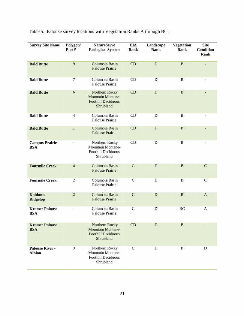
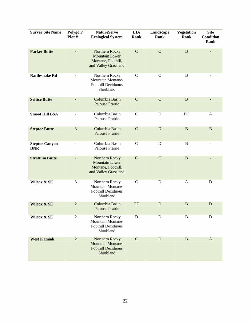
21
Table 5. Palouse survey locations with Vegetation Ranks A through BC.
Survey Site Name Polygon/
Plot #
NatureServe
Ecological System
EIA
Rank
Landscape
Rank
Vegetation
Rank
Site
Condition
Rank
Bald Butte 9 Columbia Basin Palouse Prairie
CD D B -
Bald Butte 7 Columbia Basin
Palouse Prairie
CD D B -
Bald Butte 6 Northern Rocky
Mountain Montane-
Foothill Deciduous
Shrubland
CD D B -
Bald Butte 4 Columbia Basin
Palouse Prairie
CD D B -
Bald Butte 1 Columbia Basin
Palouse Prairie
CD D B -
Campus Prairie
BSA
- Northern Rocky
Mountain Montane-
Foothill Deciduous
Shrubland
CD D B -
Fourmile Creek 4 Columbia Basin
Palouse Prairie
C D B C
Fourmile Creek 2 Columbia Basin
Palouse Prairie
C D B C
Kahlotus
Ridgetop
2 Columbia Basin
Palouse Prairie
C D B A
Kramer Palouse
BSA
- Columbia Basin
Palouse Prairie
C D BC A
Kramer Palouse
BSA
- Northern Rocky
Mountain Montane-
Foothill Deciduous
Shrubland
CD D B -
Palouse River -
Albion
3 Northern Rocky
Mountain Montane-
Foothill Deciduous
Shrubland
C D B D
22
Survey Site Name Polygon/
Plot #
NatureServe
Ecological System
EIA
Rank
Landscape
Rank
Vegetation
Rank
Site
Condition
Rank
Parker Butte - Northern Rocky
Mountain Lower
Montane, Foothill,
and Valley Grassland
C C B -
Rattlesnake Rd - Northern Rocky Mountain Montane-
Foothill Deciduous
Shrubland
C C B -
Seltice Butte - Columbia Basin
Palouse Prairie
C C B -
Smoot Hill BSA - Columbia Basin
Palouse Prairie
C D BC A
Steptoe Butte 3 Columbia Basin
Palouse Prairie
C D B B
Steptoe Canyon
DNR
- Columbia Basin
Palouse Prairie
C D B -
Strattum Butte - Northern Rocky Mountain Lower
Montane, Foothill,
and Valley Grassland
C C B -
Wilcox & SE 3 Northern Rocky
Mountain Montane-
Foothill Deciduous
Shrubland
C D A D
Wilcox & SE 2 Columbia Basin
Palouse Prairie
CD D B D
Wilcox & SE 2 Northern Rocky Mountain Montane-
Foothill Deciduous
Shrubland
D D B D
West Kamiak 2 Northern Rocky Mountain Montane-
Foothill Deciduous
Shrubland
C D B A
23
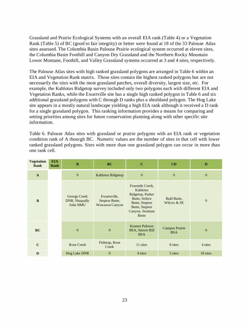
Grassland and Prairie Ecological Systems with an overall EIA rank (Table 4) or a Vegetation
Rank (Table 5) of BC (good to fair integrity) or better were found at 18 of the 33 Palouse Atlas
sites assessed. The Columbia Basin Palouse Prairie ecological system occurred at eleven sites,
the Columbia Basin Foothill and Canyon Dry Grassland and the Northern Rocky Mountain
Lower Montane, Foothill, and Valley Grassland systems occurred at 3 and 4 sites, respectively.
The Palouse Atlas sites with high ranked grassland polygons are arranged in Table 6 within an
EIA and Vegetation Rank matrix. Those sites contain the highest ranked polygons but are not
necessarily the sites with the most grassland patches, overall diversity, largest size, etc. For
example, the Kahlotus Ridgetop survey included only two polygons each with different EIA and
Vegetation Ranks, while the Ewartville site has a single high ranked polygon in Table 6 and six
additional grassland polygons with C through D ranks plus a shrubland polygon. The Hog Lake
site appears in a mostly natural landscape yielding a high EIA rank although it received a D rank
for a single grassland polygon. This ranking information provides a means for comparing and
setting priorities among sites for future conservation planning along with other specific site
information.
Table 6. Palouse Atlas sites with grassland or prairie polygons with an EIA rank or vegetation
condition rank of A thourgh BC. Numeric values are the number of sites in that cell with lower
ranked grassland polygons. Sites with more than one grassland polygon can occur in more than
one rank cell.
Vegetation
Rank
EIA
Rank B BC C CD D
A
0 Kahlotus Ridgetop 0 0 0
B
George Creek
DNR, Nisqually
John HMU
Ewartsville,
Steptoe Butte,
Wawawai Canyon
Fourmile Creek,
Kahlotus
Ridgetop, Parker
Butte, Seltice Butte, Steptoe
Butte, Steptoe
Canyon, Strattum
Butte
Bald Butte, Wilcox & SE
0
BC
0 0 Kramer Palouse BSA, Smoot Hill
BSA
Campus Prairie
BSA 0
C
Rose Creek Fishtrap, Rose
Creek 11 sites 8 sites 4 sites
D Hog Lake DNR 0 4 sites 5 sites 10 sites
24
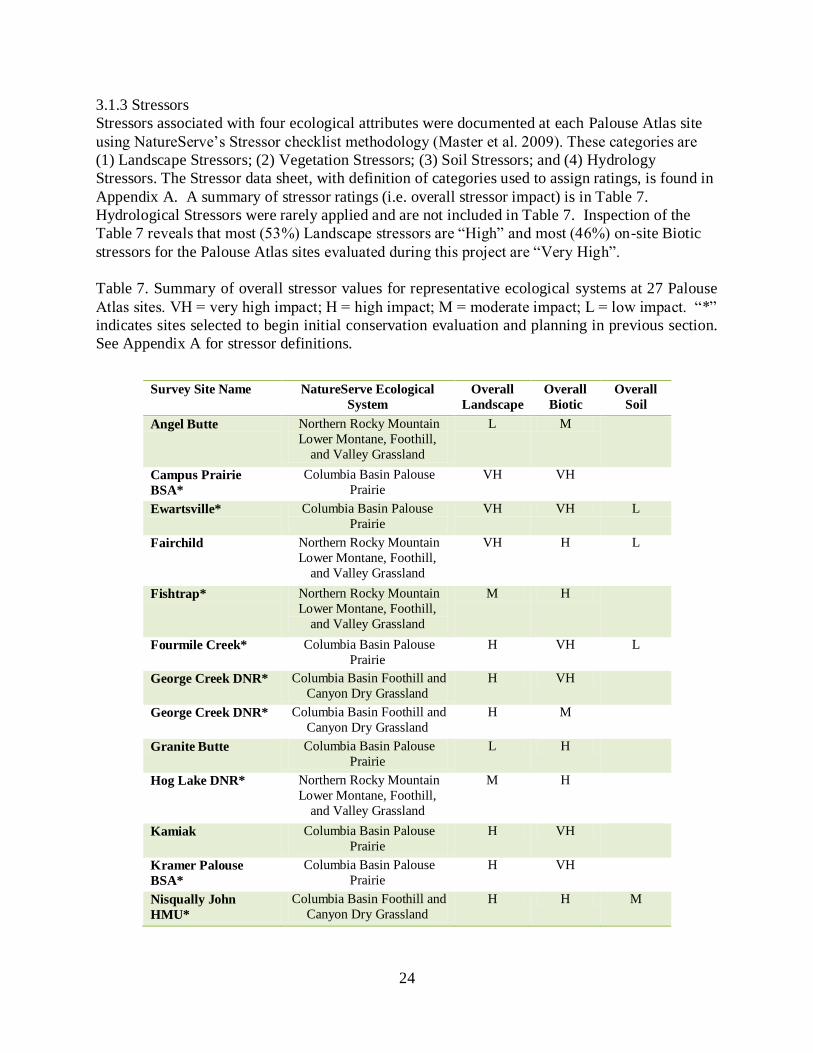
3.1.3 Stressors
Stressors associated with four ecological attributes were documented at each Palouse Atlas site
using NatureServe’s Stressor checklist methodology (Master et al. 2009). These categories are
(1) Landscape Stressors; (2) Vegetation Stressors; (3) Soil Stressors; and (4) Hydrology
Stressors. The Stressor data sheet, with definition of categories used to assign ratings, is found in
Appendix A. A summary of stressor ratings (i.e. overall stressor impact) is in Table 7.
Hydrological Stressors were rarely applied and are not included in Table 7. Inspection of the
Table 7 reveals that most (53%) Landscape stressors are “High” and most (46%) on-site Biotic
stressors for the Palouse Atlas sites evaluated during this project are “Very High”.
Table 7. Summary of overall stressor values for representative ecological systems at 27 Palouse
Atlas sites. VH = very high impact; H = high impact; M = moderate impact; L = low impact. “*”
indicates sites selected to begin initial conservation evaluation and planning in previous section.
See Appendix A for stressor definitions.
Survey Site Name NatureServe Ecological
System
Overall
Landscape
Overall
Biotic
Overall
Soil
Angel Butte Northern Rocky Mountain
Lower Montane, Foothill,
and Valley Grassland
L M
Campus Prairie
BSA*
Columbia Basin Palouse
Prairie
VH VH
Ewartsville* Columbia Basin Palouse
Prairie
VH VH L
Fairchild Northern Rocky Mountain
Lower Montane, Foothill,
and Valley Grassland
VH H L
Fishtrap* Northern Rocky Mountain
Lower Montane, Foothill,
and Valley Grassland
M H
Fourmile Creek* Columbia Basin Palouse
Prairie
H VH L
George Creek DNR* Columbia Basin Foothill and
Canyon Dry Grassland
H VH
George Creek DNR* Columbia Basin Foothill and
Canyon Dry Grassland
H M
Granite Butte Columbia Basin Palouse
Prairie
L H
Hog Lake DNR* Northern Rocky Mountain
Lower Montane, Foothill,
and Valley Grassland
M H
Kamiak Columbia Basin Palouse
Prairie
H VH
Kramer Palouse
BSA*
Columbia Basin Palouse
Prairie
H VH
Nisqually John
HMU*
Columbia Basin Foothill and
Canyon Dry Grassland
H H M
25
Survey Site Name NatureServe Ecological
System
Overall
Landscape
Overall
Biotic
Overall
Soil
Nisqually John
HMU*
Columbia Basin Foothill and
Canyon Dry Grassland
H VH M
North Wilcox Columbia Basin Palouse
Prairie
H M
Palouse River -
Albion
Columbia Basin Palouse
Prairie
H VH
Parker Butte* Northern Rocky Mountain
Lower Montane, Foothill,
and Valley Grassland
L M
Rattlesnake Rd Columbia Basin Foothill and
Canyon Dry Grassland
M VH
Rattlesnake Rd Columbia Basin Foothill and
Canyon Dry Grassland
M H
Ringo Butte Northern Rocky Mountain
Lower Montane, Foothill,
and Valley Grassland
H H
Rosalia Columbia Basin Palouse
Prairie
M VH
Rose Creek* Columbia Basin Palouse
Prairie
M M
Silver Creek Columbia Basin Palouse
Prairie
H H H
Smoot Hill BSA* Columbia Basin Palouse Prairie
H VH
Steptoe Canyon
DNR*
Columbia Basin Palouse
Prairie
H M L
Thorn Creek Columbia Basin Palouse
Prairie
H H L
Union Center Columbia Basin Palouse
Prairie
VH VH
Wawawai Canyon Columbia Basin Foothill and
Canyon Dry Grassland
M M
Wilcox & SE* Columbia Basin Palouse
Prairie
H VH L
West Kamiak Columbia Basin Palouse Prairie
H VH
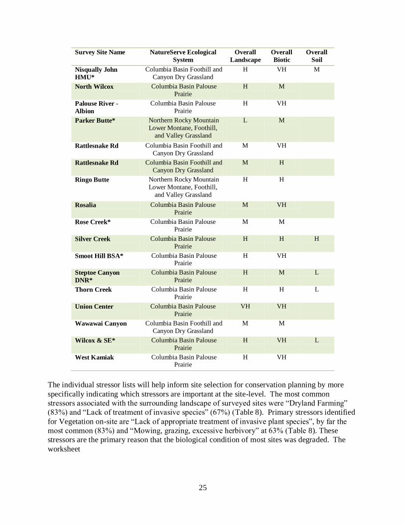
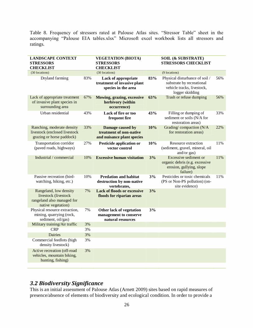
The individual stressor lists will help inform site selection for conservation planning by more
specifically indicating which stressors are important at the site-level. The most common
stressors associated with the surrounding landscape of surveyed sites were “Dryland Farming”
(83%) and “Lack of treatment of invasive species” (67%) (Table 8). Primary stressors identified
for Vegetation on-site are “Lack of appropriate treatment of invasive plant species”, by far the
most common (83%) and “Mowing, grazing, excessive herbivory” at 63% (Table 8). These
stressors are the primary reason that the biological condition of most sites was degraded. The
worksheet
26
Table 8. Frequency of stressors rated at Palouse Atlas sites. “Stressor Table” sheet in the
accompanying “Palouse EIA tables.xlsx” Microsoft excel workbook lists all stressors and
ratings.
LANDSCAPE CONTEXT
STRESSORS
CHECKLIST
VEGETATION (BIOTA)
STRESSORS
CHECKLIST
SOIL (& SUBSTRATE)
STRESSORS CHECKLIST
(30 locations) (30 locations) (9 locations)
Dryland farming 83% Lack of appropriate
treatment of invasive plant
species in the area
83% Physical disturbance of soil /
substrate by recreational
vehicle tracks, livestock,
logger skidding
56%
Lack of appropriate treatment
of invasive plant species in
surrounding area
67% Mowing, grazing, excessive
herbivory (within
occurrence)
63% Trash or refuse dumping 56%
Urban residential 43% Lack of fire or too
frequent fire
43% Filling or dumping of
sediment or soils (N/A for
restoration areas)
33%
Ranching, moderate density
livestock (enclosed livestock
grazing or horse paddock)
33% Damage caused by
treatment of non-native
and nuisance plant species
10% Grading/ compaction (N/A
for restoration areas)
22%
Transportation corridor
(paved roads, highways)
27% Pesticide application or
vector control
10% Resource extraction
(sediment, gravel, mineral, oil
and/or gas)
11%
Industrial / commercial 10% Excessive human visitation 3% Excessive sediment or
organic debris (e.g. excessive
erosion, gullying, slope
failure)
11%
Passive recreation (bird-
watching, hiking, etc.)
10% Predation and habitat
destruction by non-native
vertebrates,
3% Pesticides or toxic chemicals
(PS or Non-PS pollution) (on-
site evidence)
11%
Rangeland, low density
livestock (livestock
rangeland also managed for
native vegetation)
7% Lack of floods or excessive
floods for riparian areas
3%
Physical resource extraction,
mining, quarrying (rock,
sediment, oil/gas)
7% Other lack of vegetation
management to conserve
natural resources
3%
Military training/Air traffic 3%
CRP 3%
Dairies 3%
Commercial feedlots (high
density livestock)
3%
Active recreation (off-road
vehicles, mountain biking,
hunting, fishing)
3%
3.2 Biodiversity Significance This is an initial assessment of Palouse Atlas (Arnett 2009) sites based on rapid measures of
presence/absence of elements of biodiversity and ecological condition. In order to provide a
27
more comprehensive assessment of the biodiversity values of these Palouse sites, additional on-
site inventory and assessment is needed to better estimate the more specific ecological condition
and elements of biodiversity. Nonetheless, the data collected in this project provide a good first
measure of biodiversity significance of Palouse Prairie sites in Washington.
3.2.1 Elements of Conservation Concern
Plant Associations
In addition to the presence of rare species at prairie remnants the prairie communities themselves
are conservation concern. Of the 11 plant associations identified in the field, five have a Global
Rank of G1 or G2 (critically imperiled or imperiled across their full range) and two others are G3
or vulnerable (Table 2). These rankings further emphasize the conservation needs of the region.
28
Literature Cited
Arnett, J.2009. Site Conservation Planning: Palouse Region Atlas and Floristic Review. Prepared
for Region 1, USFWS. Washington Natural Heritage Program, Wa. Dept. Nat.Res. Olympia,
Wa.
Black, A.E., E. Strand, R. G. Wright, J. M. Scott, P. Morgan and C. Watson. 1998. Land use
history at multiple scales: implications for conservation planning. Landscape and Urban Planning
43(1): 49-63. Comer, P., D. Faber-Langendoen, R. Evans, S. Gawler, C. Josse, G. Kittel, S.
Menard, M. Pyne, M. Reid, K. Schulz, K. Snow, and J. Teague. 2003. Ecological Systems of the
United States: A Working Classification of U.S. Terrestrial Systems. NatureServe, Arlington,
VA.
Comer, P., D. Faber-Langendoen, R. Evans, S. Gawler, C. Josse, G. Kittel, S. Menard, M. Pyne,
M. Reid, K. Schulz, K. Snow, and J. Teague. 2003. Ecological Systems of the United States: A
Working Classification of U.S. Terrestrial Systems. NatureServe, Arlington, Virginia.
Comer, P., and K. Schulz. 2007. Standardized Ecological Classification for Meso-Scale Mapping
in Southwest United States. Rangeland Ecology and Management 60 (3) 324-335.
Faber-Langendoen, D., J. Rocchio, M. Shafale, C. Nordman, M. Pyne, J. Teague, and T. Foti.
2006. Ecological Integrity Assessment and Performance Measures for Wetland Mitigation.
NatureServe, Arlington VA. Available online at:
http://www.natureserve.org/getData/eia_integrity_reports.jsp
Faber-Langendoen, D., G. Kudray, C. Nordman, L. Sneddon, L. Vance, E. Byers, J. Rocchio, S.
Gawler, G. Kittel, S. Menard, P. Comer, E. Muldavin, M. Schafale, T. Foti, C. Josse, J. Christy.
2008a. Ecological Performance Standards for Wetland Mitigation based on Ecological Integrity
Assessments. NatureServe, Arlington, VA. + Appendices
Faber-Langendoen, D, J. Rocchio, P. Comer, G. Kudray, L. Vance, E. Byers, M. Schafale, P.
Comer, C. Nordman, E. Muldavin, G. Kittel, L. Sneddon, M. Pyne and S. Menard. 2008b.
Overview of Natural Heritage Methodology for Ecological Element Occurrence Ranking based
on Ecological Integrity Assessment Methods [Draft for Network Review]. NatureServe,
Arlington, VA
Faber-Langendoen, D., G. Kudray, C. Nordman, L. Sneddon, L. Vance, E. Byers, J. Rocchio, S.
Gawler, G. Kittel, S. Menard, P. Comer, E. Muldavin, M. Schafale, T. Foti, C. Josse, J. Christy.
2009a. NatureServe Level 2 and Level 3 Ecological Integrity Assessments: Wetlands.
NatureServe, Arlington, VA. + Appendices
Faber-Langendoen, Don, Regan Lyons, and Pat Comer. 2009b. Developing options for
establishing reference conditions for wetlands across the lower 48 states. A report to the U.S.
Environmental Protection Agency. NatureServe, Arlington, VA.
29
Faber-Langendoen, D., D.L. Tart, and R.H. Crawford. 2009c. Contours of the revised U.S.
National Vegetation Classification standard. Bulletin of the Ecological Society of America
90:87-93.
Federal Geographic Data Committee. 2008. Vegetation Classification Standard, version 2
FGDC-STD-005, v2. Washington, DC.
Harwell, M.A., V. Myers, T. Young, A. Bartuska, N. Gassman, J. H.Gentile, C. C. Harwell, S.
Appelbaum, J. Barko, B. Causey, C. Johnson, A. McLean, R. Smola, P. Templet, and S. Tosini.
1999. A framework for an ecosystem integrity report card. BioScience 49: 543-556.
Jennings, M.D., D. Faber-Langendoen, R.K. Peet, O.L. Loucks, M.G. Barbour, and D. Roberts.
2009. Standards for associations and alliances of the U.S. National Vegetation Classification.
Ecological Monographs 79:.173–199.
Lemly, J.M. & Rocchio, J.R. 2009.Field Testing and Validation of the Subalpine-Montane
Riparian Shrublands Ecological Integrity Assessment (EIA) Scorecard in the Blue River
Watershed, Colorado. Unpublished report prepared for the Colorado Division of Wildlife and US
EPA Region 8 by the Colorado Natural Heritage Program, Colorado State University, Fort
Collins, CO.
Master, L., D. Faber-Langendoen, R. Bittman, G. A. Hammerson, B. Heidel, J. Nichols, L.
Ramsay, and A. Tomaino. 2009. NatureServe Conservation Status Assessments: Factors for
Assessing Extinction Risk. NatureServe, Arlington, VA.
Mack, J. J. 2004. Integrated Wetland Assessment Program. Part 4: Vegetation Index of Biotic
Integrity (VIBI) and Tiered Aquatic Life Uses (TALUs) for Ohio wetlands. Ohio EPA Technical
Report WET/2004-4. Ohio Environmental Protection Agency, Wetland Ecology Group, Division
of Surface Water, Columbus, Ohio.
NatureServe. 2011. NatureServe Explorer: An online encyclopedia of life [web application].
Version 7.1. NatureServe, Arlington, Virginia. Available http://www.natureserve.org/explorer.
(Accessed: December 2011).
Rocchio, F.J. and R.C. Crawford. 2008. Draft Field Guide to Washington’s Ecological Systems.
Draft report prepared by the Washington Natural Heritage Program, Washington Department of
Natural Resources. Olympia, WA.
Rocchio, F.J. and R.C. Crawford. 2009. Monitoring Desired Ecological Conditions on
Washington State Wildlife Areas Using an Ecological Integrity Assessment Framework. Report
prepared for the Washington Department of Fish and Wildlife. Washington Natural Heritage
Program, Washington Department of Natural Resources. Olympia, WA.
Tierney, G.L., D. Faber-Langendoen, B. R. Mitchell, W.G. Shriver, and J.P. Gibbs. 2009.
Monitoring and evaluating the ecological integrity of forest ecosystems. Frontiers in Ecology and
the Environment 7(6): 308-316.

30
Vance, L., J. Lemly, G. Jones and K. Newlon. In progress. Identification of Ecological Integrity
Attributes, Indicators and Metrics for Six Wetland Ecological Systems in the Rocky Mountains.
A Regional Environmental Monitoring and Assessment Program (REMAP) project funded by
U.S. EPA Region 8.
Washington Natural Heritage Program (WNHP). 2010. Ecological Integrity Assessments for
Washington’s Ecological Systems. Washington Department of Natural Resources, Natural
Heritage Program. Olympia, WA. Online:
http://www1.dnr.wa.gov/nhp/refdesk/communities/eia_list.html
Young, T.F. and S. Sanzone (editors). 2002. A framework for assessing and reporting on
ecological condition. Prepared by the Ecological Reporting Panel, Ecological Processes and
Effects Committee. EPA Science Advisory Board. Washington, DC. 142 p.
31
Appendices
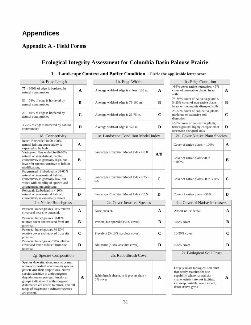
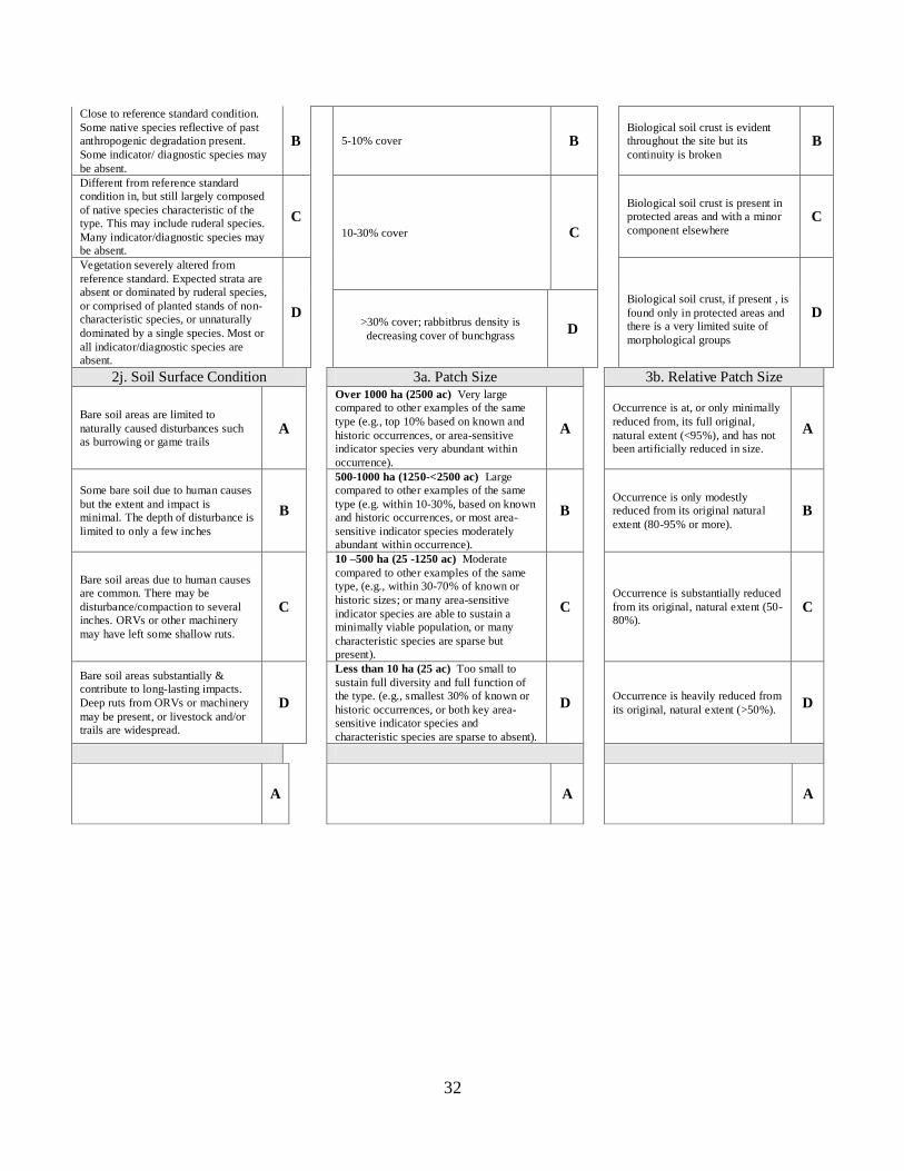
Appendix A - Field Forms
Ecological Integrity Assessment for Columbia Basin Palouse Prairie
1. Landscape Context and Buffer Condition - Circle the applicable letter score
1a. Edge Length 1b. Edge Width 1c. Edge Condition
75 – 100% of edge is bordered by
natural communities A Average width of edge is at least 100 m. A
>95% cover native vegetation, <5%
cover of non-native plants, intact
soils A
50 – 74% of edge is bordered by
natural communities B Average width of edge is 75-100 m. B
75–95% cover of native vegetation,
5–25% cover of non-native plants,
intact or moderately disrupted soils B
25 – 49% of edge is bordered by
natural communities C Average width of edge is 25-75 m. C
25–50% cover of non-native plants,
moderate or extensive soil
disruption C
< 25% of edge is bordered by natural
communities D Average width of edge is <25 m. D
>50% cover of non-native plants,
barren ground, highly compacted or
otherwise disrupted soils D
1d. Connectivity 1e. Landscape Condition Model Index 2a. Cover Native Plant Species Intact: Embedded in 90-100%
natural habitat; connectivity is
expected to be high. A
Landscape Condition Model Index > 0.8
A/B
Cover of native plants = 100%. A
Variegated: Embedded in 60-90%
natural or semi-habitat; habitat
connectivity is generally high, but
lower for species sensitive to habitat
modification;
B Cover of native plants 90 to
<100%. B
Fragmented: Embedded in 20-60%
natural or semi-natural habitat;
connectivity is generally low, but
varies with mobility of species and
arrangement on landscape.
C Landscape Condition Model Index 0.75 –
0.5 C Cover of native plants 50 to <90%. C
Relictual: Embedded in < 20%
natural or semi-natural habitat;
connectivity is essentially absent D Landscape Condition Model Index < 0.5 D Cover of native plants <50%. D
2b. Native Bunchgrass 2c. Cover Invasive Species 2d. Cover of Native Increasers
Perennial bunchgrasses 80% relative
cover and near site potential. A None present. A Absent or incidental A
Perennial bunchgrasses 50-80%
relative cover and reduced from site
potential. B Present, but sporadic (<3% cover). B <10% cover B
Perennial bunchgrasses 30-50%
relative cover and reduced from site
potential. C Prevalent (3–10% absolute cover). C 10-20% cover C
Perennial bunchgrass <30% relative
cover and much reduced from site
potential. D Abundant (>10% absolute cover). D >20% cover D
2g. Species Composition 2h. Rabbitbrush Cover 2i. Biological Soil Crust
Species diversity/abundance at or near
reference standard condition in species
present and their proportions. Native
species sensitive to anthropogenic
degradation are present, functional
groups indicative of anthropogenic
disturbance are absent to minor, and full
range of diagnostic / indicator species
are present.
A Rabbitbrush absent, or if present then <
5% cover A
Largely intact biological soil crust
that nearly matches the site
capability where natural site
characteristics are not limiting,
i.e. steep unstable, south aspect,
dense native grass
A
32
Close to reference standard condition.
Some native species reflective of past
anthropogenic degradation present.
Some indicator/ diagnostic species may
be absent.
B 5-10% cover B Biological soil crust is evident
throughout the site but its
continuity is broken B
Different from reference standard
condition in, but still largely composed
of native species characteristic of the
type. This may include ruderal species.
Many indicator/diagnostic species may
be absent.
C 10-30% cover C
Biological soil crust is present in
protected areas and with a minor
component elsewhere C
Vegetation severely altered from
reference standard. Expected strata are
absent or dominated by ruderal species,
or comprised of planted stands of non-
characteristic species, or unnaturally
dominated by a single species. Most or
all indicator/diagnostic species are
absent.
D
Biological soil crust, if present , is
found only in protected areas and
there is a very limited suite of
morphological groups
D >30% cover; rabbitbrus density is
decreasing cover of bunchgrass D
2j. Soil Surface Condition 3a. Patch Size 3b. Relative Patch Size
Bare soil areas are limited to
naturally caused disturbances such
as burrowing or game trails A
Over 1000 ha (2500 ac) Very large
compared to other examples of the same
type (e.g., top 10% based on known and
historic occurrences, or area-sensitive
indicator species very abundant within
occurrence).
A
Occurrence is at, or only minimally
reduced from, its full original,
natural extent (<95%), and has not
been artificially reduced in size.
A
Some bare soil due to human causes
but the extent and impact is
minimal. The depth of disturbance is
limited to only a few inches
B
500-1000 ha (1250-<2500 ac) Large
compared to other examples of the same
type (e.g. within 10-30%, based on known
and historic occurrences, or most area-
sensitive indicator species moderately
abundant within occurrence).
B Occurrence is only modestly
reduced from its original natural
extent (80-95% or more). B
Bare soil areas due to human causes
are common. There may be
disturbance/compaction to several
inches. ORVs or other machinery
may have left some shallow ruts.
C
10 –500 ha (25 -1250 ac) Moderate
compared to other examples of the same
type, (e.g., within 30-70% of known or
historic sizes; or many area-sensitive
indicator species are able to sustain a
minimally viable population, or many
characteristic species are sparse but
present).
C Occurrence is substantially reduced
from its original, natural extent (50-
80%). C
Bare soil areas substantially &
contribute to long-lasting impacts.
Deep ruts from ORVs or machinery
may be present, or livestock and/or
trails are widespread.
D
Less than 10 ha (25 ac) Too small to
sustain full diversity and full function of
the type. (e.g., smallest 30% of known or
historic occurrences, or both key area-
sensitive indicator species and
characteristic species are sparse to absent).
D Occurrence is heavily reduced from
its original, natural extent (>50%). D
A A A
33
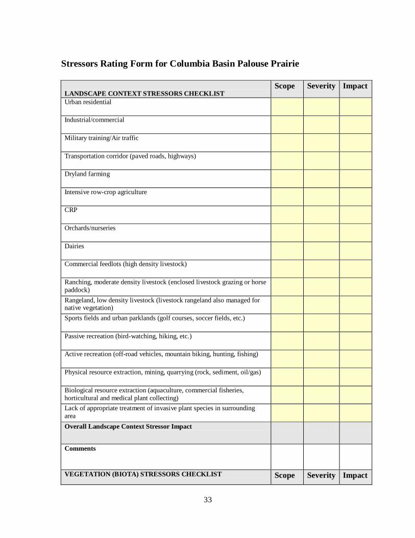
Stressors Rating Form for Columbia Basin Palouse Prairie
LANDSCAPE CONTEXT STRESSORS CHECKLIST Scope Severity Impact
Urban residential
Industrial/commercial
Military training/Air traffic
Transportation corridor (paved roads, highways)
Dryland farming
Intensive row-crop agriculture
CRP
Orchards/nurseries
Dairies
Commercial feedlots (high density livestock)
Ranching, moderate density livestock (enclosed livestock grazing or horse
paddock)
Rangeland, low density livestock (livestock rangeland also managed for native vegetation)
Sports fields and urban parklands (golf courses, soccer fields, etc.)
Passive recreation (bird-watching, hiking, etc.)
Active recreation (off-road vehicles, mountain biking, hunting, fishing)
Physical resource extraction, mining, quarrying (rock, sediment, oil/gas)
Biological resource extraction (aquaculture, commercial fisheries,
horticultural and medical plant collecting)
Lack of appropriate treatment of invasive plant species in surrounding
area
Overall Landscape Context Stressor Impact
Comments
VEGETATION (BIOTA) STRESSORS CHECKLIST Scope Severity Impact
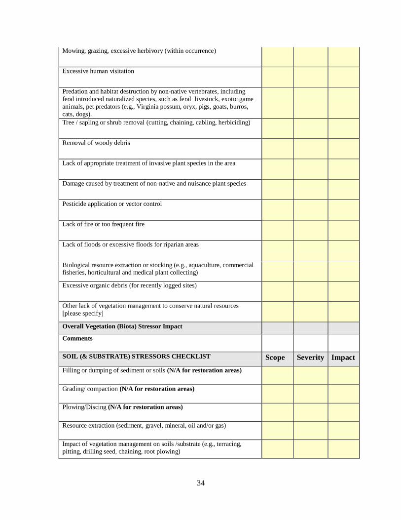
34
Mowing, grazing, excessive herbivory (within occurrence)
Excessive human visitation
Predation and habitat destruction by non-native vertebrates, including
feral introduced naturalized species, such as feral livestock, exotic game
animals, pet predators (e.g., Virginia possum, oryx, pigs, goats, burros,
cats, dogs).
Tree / sapling or shrub removal (cutting, chaining, cabling, herbiciding)
Removal of woody debris
Lack of appropriate treatment of invasive plant species in the area
Damage caused by treatment of non-native and nuisance plant species
Pesticide application or vector control
Lack of fire or too frequent fire
Lack of floods or excessive floods for riparian areas
Biological resource extraction or stocking (e.g., aquaculture, commercial fisheries, horticultural and medical plant collecting)
Excessive organic debris (for recently logged sites)
Other lack of vegetation management to conserve natural resources
[please specify]
Overall Vegetation (Biota) Stressor Impact
Comments
SOIL (& SUBSTRATE) STRESSORS CHECKLIST Scope Severity Impact
Filling or dumping of sediment or soils (N/A for restoration areas)
Grading/ compaction (N/A for restoration areas)
Plowing/Discing (N/A for restoration areas)
Resource extraction (sediment, gravel, mineral, oil and/or gas)
Impact of vegetation management on soils /substrate (e.g., terracing,
pitting, drilling seed, chaining, root plowing)
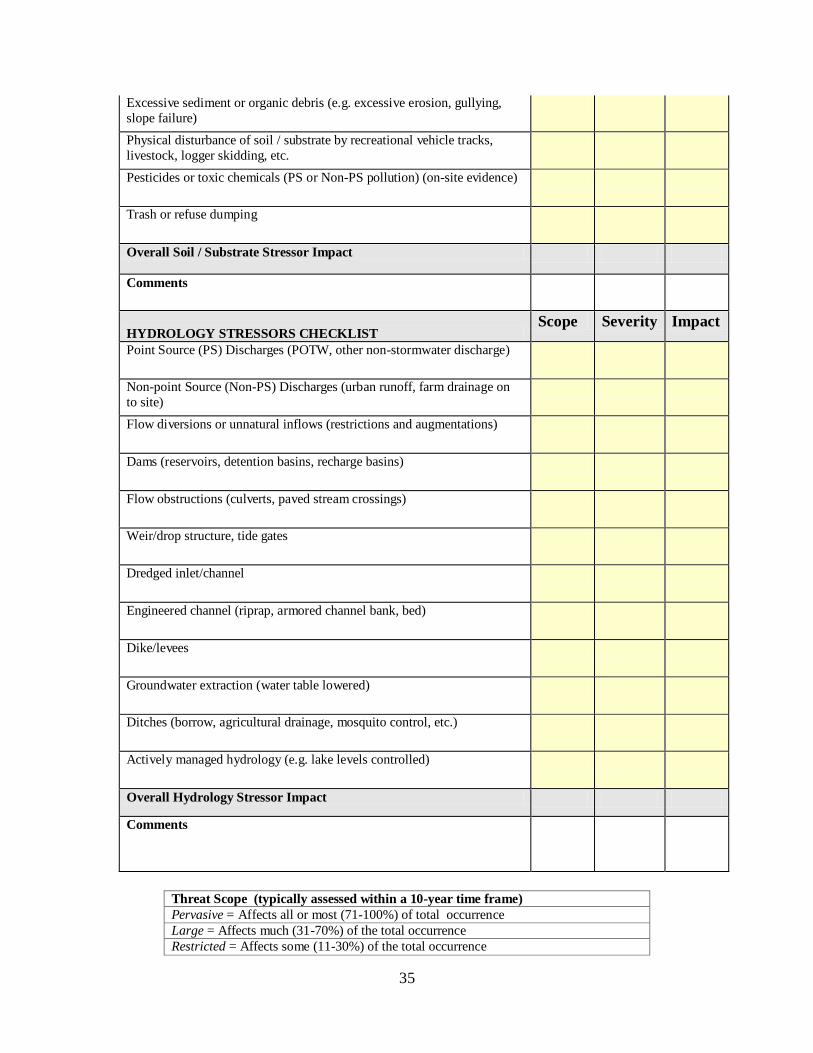
35
Excessive sediment or organic debris (e.g. excessive erosion, gullying,
slope failure)
Physical disturbance of soil / substrate by recreational vehicle tracks,
livestock, logger skidding, etc.
Pesticides or toxic chemicals (PS or Non-PS pollution) (on-site evidence)
Trash or refuse dumping
Overall Soil / Substrate Stressor Impact
Comments
HYDROLOGY STRESSORS CHECKLIST Scope Severity Impact
Point Source (PS) Discharges (POTW, other non-stormwater discharge)
Non-point Source (Non-PS) Discharges (urban runoff, farm drainage on
to site)
Flow diversions or unnatural inflows (restrictions and augmentations)
Dams (reservoirs, detention basins, recharge basins)
Flow obstructions (culverts, paved stream crossings)
Weir/drop structure, tide gates
Dredged inlet/channel
Engineered channel (riprap, armored channel bank, bed)
Dike/levees
Groundwater extraction (water table lowered)
Ditches (borrow, agricultural drainage, mosquito control, etc.)
Actively managed hydrology (e.g. lake levels controlled)
Overall Hydrology Stressor Impact
Comments
Threat Scope (typically assessed within a 10-year time frame)
Pervasive = Affects all or most (71-100%) of total occurrence
Large = Affects much (31-70%) of the total occurrence
Restricted = Affects some (11-30%) of the total occurrence
36
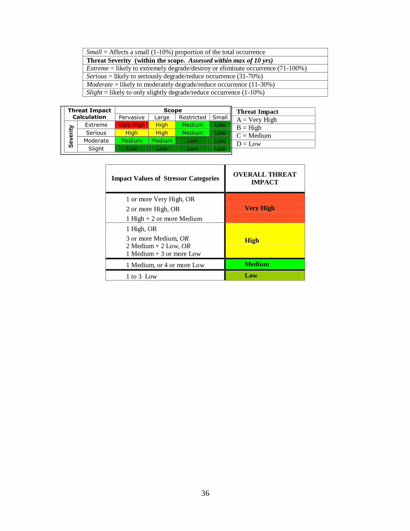
Small = Affects a small (1-10%) proportion of the total occurrence
Threat Severity (within the scope. Assessed within max of 10 yrs)
Extreme = likely to extremely degrade/destroy or eliminate occurrence (71-100%)
Serious = likely to seriously degrade/reduce occurrence (31-70%)
Moderate = likely to moderately degrade/reduce occurrence (11-30%)
Slight = likely to only slightly degrade/reduce occurrence (1-10%)
Impact Values of Stressor Categories OVERALL THREAT
IMPACT
1 or more Very High, OR
2 or more High, OR
1 High + 2 or more Medium
Very High
1 High, OR
3 or more Medium, OR 2 Medium + 2 Low, OR
1 Medium + 3 or more Low
High
1 Medium, or 4 or more Low Medium
1 to 3 Low Low
Threat Impact
A = Very High
B = High
C = Medium
D = Low
Scope Threat Impact Calculation Pervasive Large Restricted Small
Extreme Very High High Medium Low
Serious High High Medium Low
Moderate Medium Medium Low Low
Se
ve
rity
Slight Low Low Low Low
37
Appendix B
Palouse Atlas – Ecological Integrity Assessments (Modified Appendix B in Arnett, 2009)
Contents
Overview Maps.......................................................................................................................38
Distribution of Palouse rare plant species .............................................................................40
Selected Palouse Sites ............................................................................................................44
38
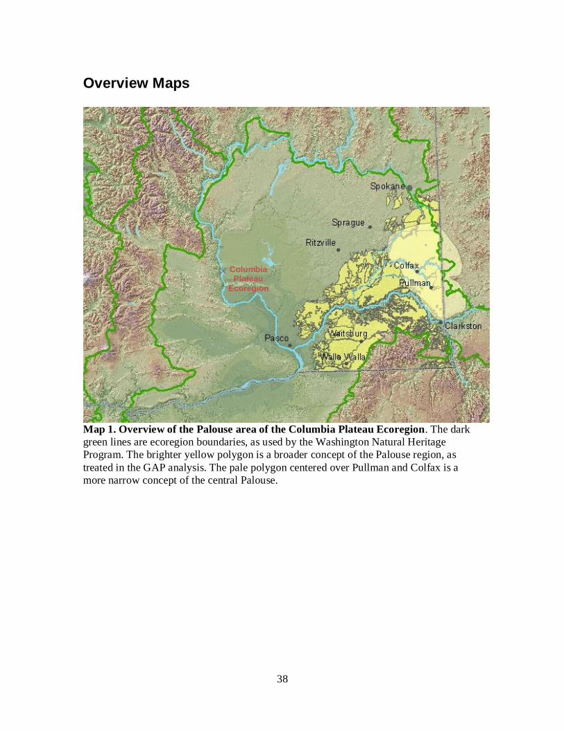
Overview Maps
Map 1. Overview of the Palouse area of the Columbia Plateau Ecoregion. The dark
green lines are ecoregion boundaries, as used by the Washington Natural Heritage
Program. The brighter yellow polygon is a broader concept of the Palouse region, as
treated in the GAP analysis. The pale polygon centered over Pullman and Colfax is a
more narrow concept of the central Palouse.
Columbia Plateau
Ecoregion
39
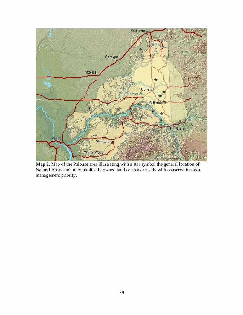
Map 2. Map of the Palouse area illustrating with a star symbol the general location of
Natural Areas and other publically owned land or areas already with conservation as a
management priority.
40
Distribution of Palouse rare plant species
Map 3. Astragalus arthurii
Map 4. Astragalus riparius
Map 5. Calochortus nitidus
Map 6. Howellia aquatilis
Map 7. Lomatium rollinsii
Map 8. Lomatium serpentinum
Map 9. Lupinus sabianus
Map 10. Lupinus sulphureus var. asotinensis
Map 11. Oenothera caespitosa ssp. marginata
Map 12. Pyrrocoma liatriformis/P. scaberula
Map 13. Rubus nigerrimus
Map 14. Sclerolinon digynum
Map 15. Silene spaldingii
Map 16. Symphyotrichum jessicae
Map 17. Trichostema oblongum
Map 18. Trifolium douglasii
41
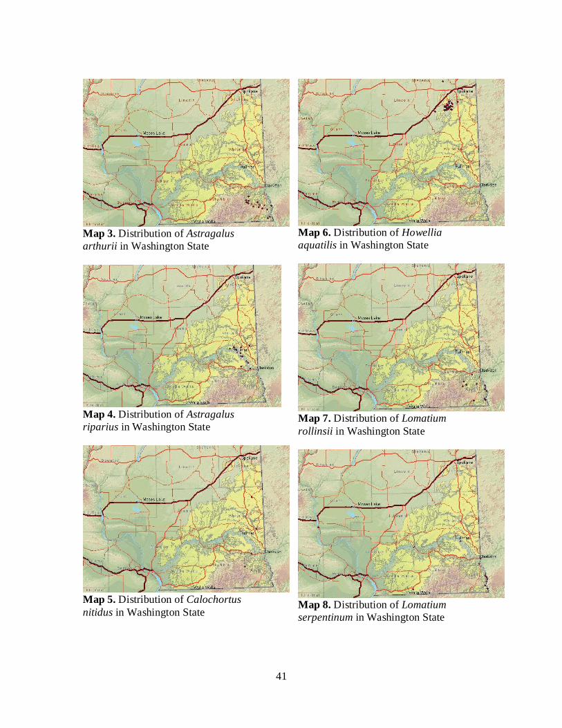
Map 3. Distribution of Astragalus
arthurii in Washington State
Map 4. Distribution of Astragalus
riparius in Washington State
Map 5. Distribution of Calochortus
nitidus in Washington State
Map 6. Distribution of Howellia
aquatilis in Washington State
Map 7. Distribution of Lomatium
rollinsii in Washington State
Map 8. Distribution of Lomatium
serpentinum in Washington State
42
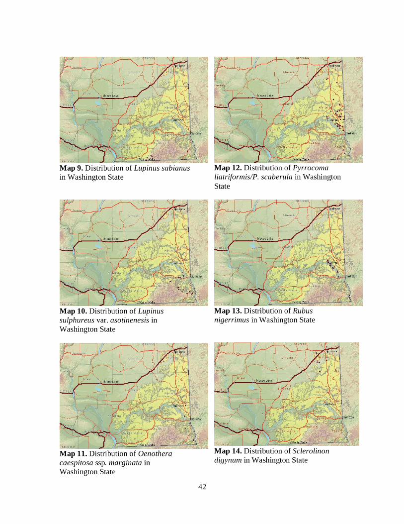
Map 9. Distribution of Lupinus sabianus
in Washington State
Map 10. Distribution of Lupinus
sulphureus var. asotinenesis in
Washington State
Map 11. Distribution of Oenothera
caespitosa ssp. marginata in
Washington State
Map 12. Distribution of Pyrrocoma
liatriformis/P. scaberula in Washington
State
Map 13. Distribution of Rubus
nigerrimus in Washington State
Map 14. Distribution of Sclerolinon
digynum in Washington State
43
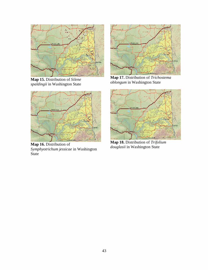
Map 15. Distribution of Silene
spaldingii in Washington State
Map 16. Distribution of
Symphyotrichum jessicae in Washington
State
Map 17. Distribution of Trichostema
oblongum in Washington State
Map 18. Distribution of Trifolium
douglasii in Washington State
44
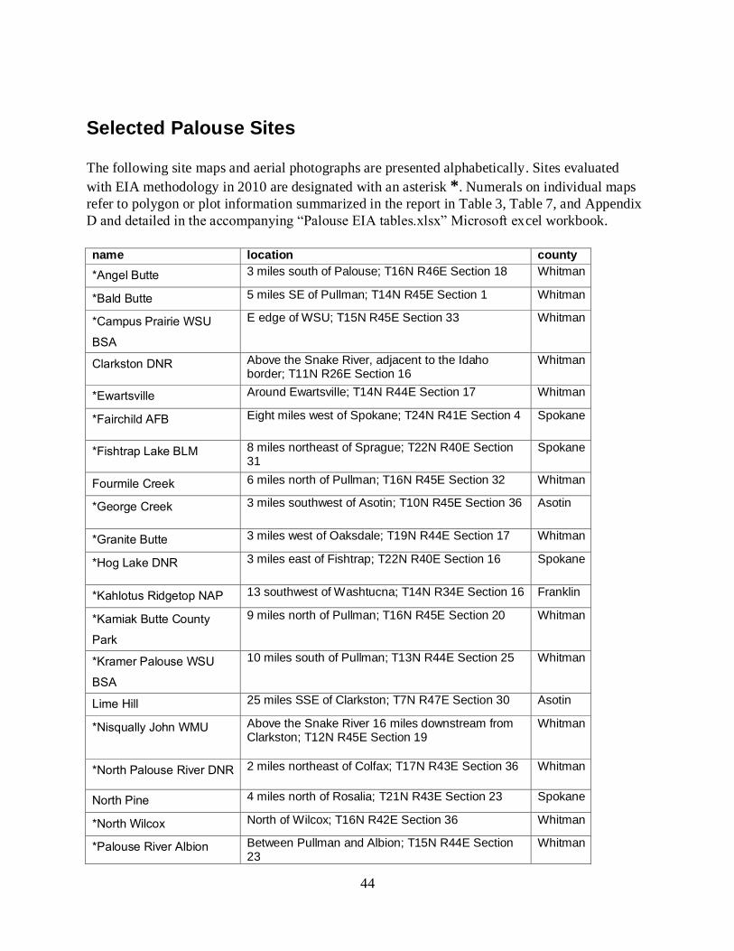
Selected Palouse Sites
The following site maps and aerial photographs are presented alphabetically. Sites evaluated
with EIA methodology in 2010 are designated with an asterisk *. Numerals on individual maps
refer to polygon or plot information summarized in the report in Table 3, Table 7, and Appendix
D and detailed in the accompanying “Palouse EIA tables.xlsx” Microsoft excel workbook.
name location county
*Angel Butte 3 miles south of Palouse; T16N R46E Section 18 Whitman
*Bald Butte 5 miles SE of Pullman; T14N R45E Section 1 Whitman
*Campus Prairie WSU
BSA
E edge of WSU; T15N R45E Section 33 Whitman
Clarkston DNR Above the Snake River, adjacent to the Idaho border; T11N R26E Section 16
Whitman
*Ewartsville Around Ewartsville; T14N R44E Section 17 Whitman
*Fairchild AFB Eight miles west of Spokane; T24N R41E Section 4 Spokane
*Fishtrap Lake BLM 8 miles northeast of Sprague; T22N R40E Section 31
Spokane
Fourmile Creek 6 miles north of Pullman; T16N R45E Section 32 Whitman
*George Creek 3 miles southwest of Asotin; T10N R45E Section 36 Asotin
*Granite Butte 3 miles west of Oaksdale; T19N R44E Section 17 Whitman
*Hog Lake DNR 3 miles east of Fishtrap; T22N R40E Section 16 Spokane
*Kahlotus Ridgetop NAP 13 southwest of Washtucna; T14N R34E Section 16 Franklin
*Kamiak Butte County
Park
9 miles north of Pullman; T16N R45E Section 20 Whitman
*Kramer Palouse WSU
BSA
10 miles south of Pullman; T13N R44E Section 25 Whitman
Lime Hill 25 miles SSE of Clarkston; T7N R47E Section 30 Asotin
*Nisqually John WMU Above the Snake River 16 miles downstream from Clarkston; T12N R45E Section 19
Whitman
*North Palouse River DNR 2 miles northeast of Colfax; T17N R43E Section 36 Whitman
North Pine 4 miles north of Rosalia; T21N R43E Section 23 Spokane
*North Wilcox North of Wilcox; T16N R42E Section 36 Whitman
*Palouse River Albion Between Pullman and Albion; T15N R44E Section 23
Whitman
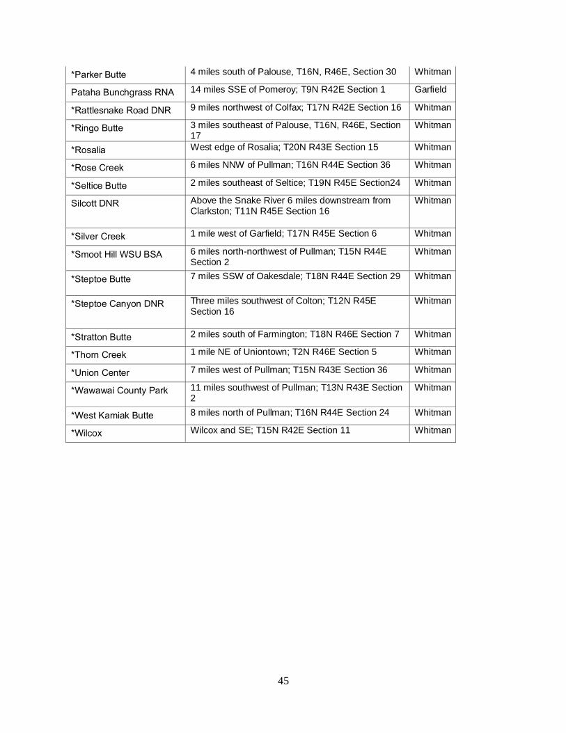
45
*Parker Butte 4 miles south of Palouse, T16N, R46E, Section 30 Whitman
Pataha Bunchgrass RNA 14 miles SSE of Pomeroy; T9N R42E Section 1 Garfield
*Rattlesnake Road DNR 9 miles northwest of Colfax; T17N R42E Section 16 Whitman
*Ringo Butte 3 miles southeast of Palouse, T16N, R46E, Section 17
Whitman
*Rosalia West edge of Rosalia; T20N R43E Section 15 Whitman
*Rose Creek 6 miles NNW of Pullman; T16N R44E Section 36 Whitman
*Seltice Butte 2 miles southeast of Seltice; T19N R45E Section24 Whitman
Silcott DNR Above the Snake River 6 miles downstream from Clarkston; T11N R45E Section 16
Whitman
*Silver Creek 1 mile west of Garfield; T17N R45E Section 6 Whitman
*Smoot Hill WSU BSA 6 miles north-northwest of Pullman; T15N R44E Section 2
Whitman
*Steptoe Butte 7 miles SSW of Oakesdale; T18N R44E Section 29 Whitman
*Steptoe Canyon DNR Three miles southwest of Colton; T12N R45E Section 16
Whitman
*Stratton Butte 2 miles south of Farmington; T18N R46E Section 7 Whitman
*Thorn Creek 1 mile NE of Uniontown; T2N R46E Section 5 Whitman
*Union Center 7 miles west of Pullman; T15N R43E Section 36 Whitman
*Wawawai County Park 11 miles southwest of Pullman; T13N R43E Section 2
Whitman
*West Kamiak Butte 8 miles north of Pullman; T16N R44E Section 24 Whitman
*Wilcox Wilcox and SE; T15N R42E Section 11 Whitman
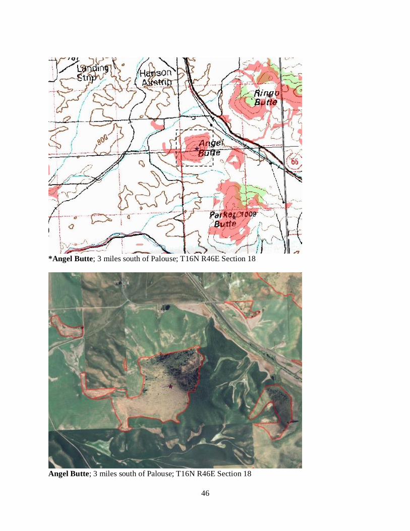
46
*Angel Butte; 3 miles south of Palouse; T16N R46E Section 18
Angel Butte; 3 miles south of Palouse; T16N R46E Section 18
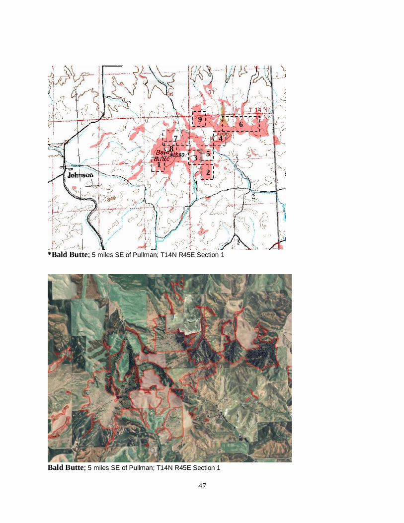
47
*Bald Butte; 5 miles SE of Pullman; T14N R45E Section 1
Bald Butte; 5 miles SE of Pullman; T14N R45E Section 1
9
8
7
6
5
4
2
3 1
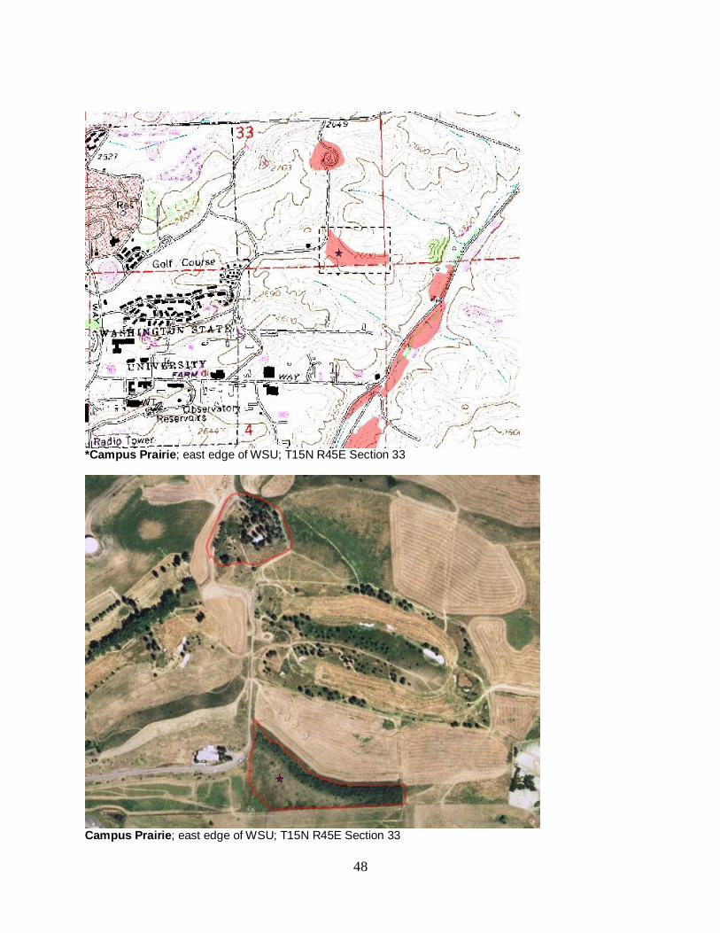
48
*Campus Prairie; east edge of WSU; T15N R45E Section 33
Campus Prairie; east edge of WSU; T15N R45E Section 33
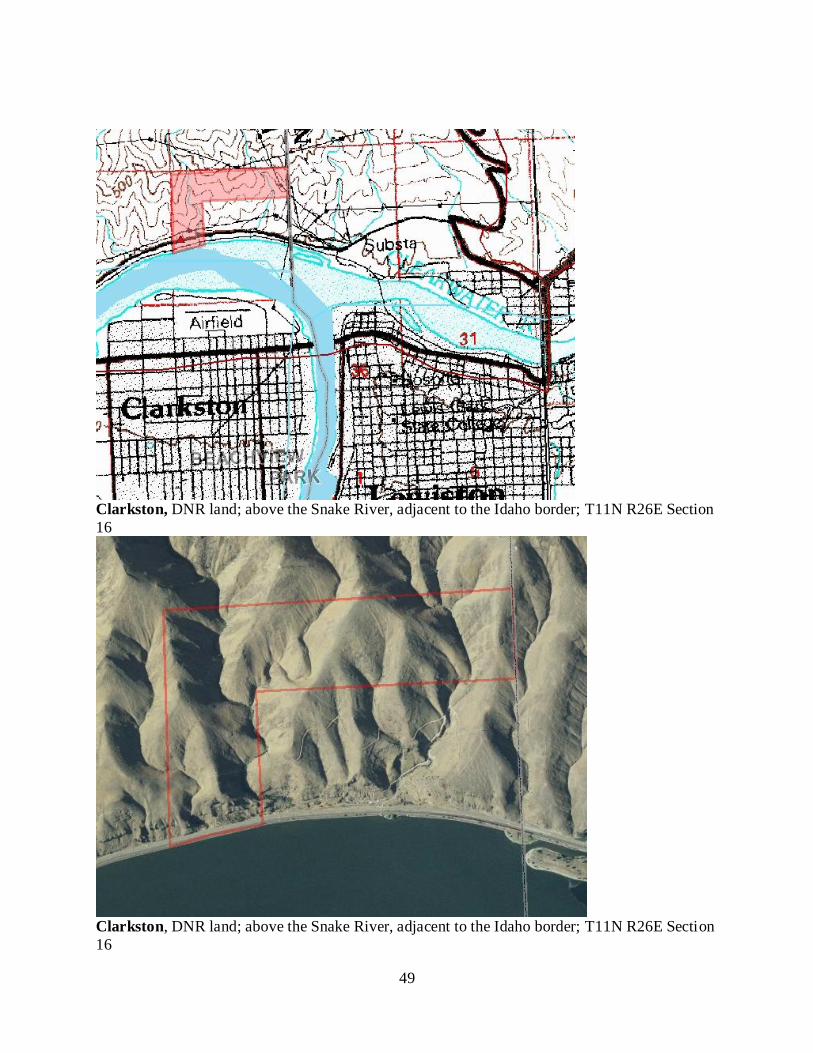
49
Clarkston, DNR land; above the Snake River, adjacent to the Idaho border; T11N R26E Section
16
Clarkston, DNR land; above the Snake River, adjacent to the Idaho border; T11N R26E Section
16
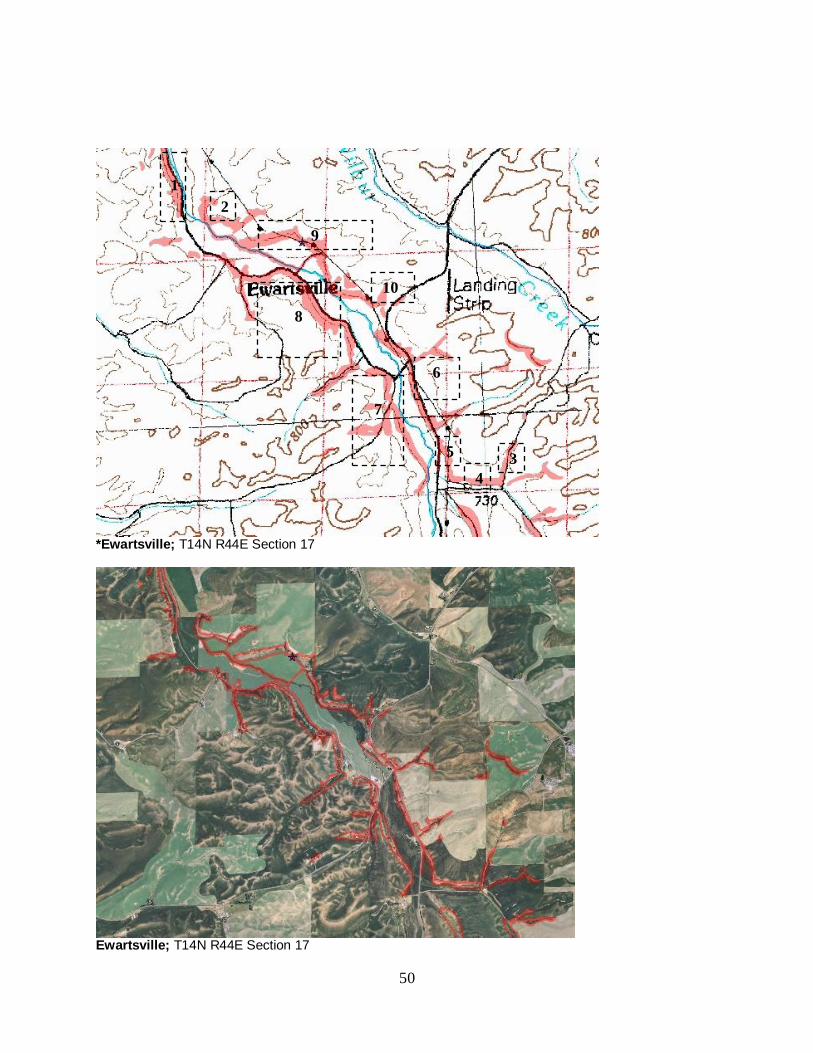
50
*Ewartsville; T14N R44E Section 17
Ewartsville; T14N R44E Section 17
1
2
3
4
5
6
7
8
9
10
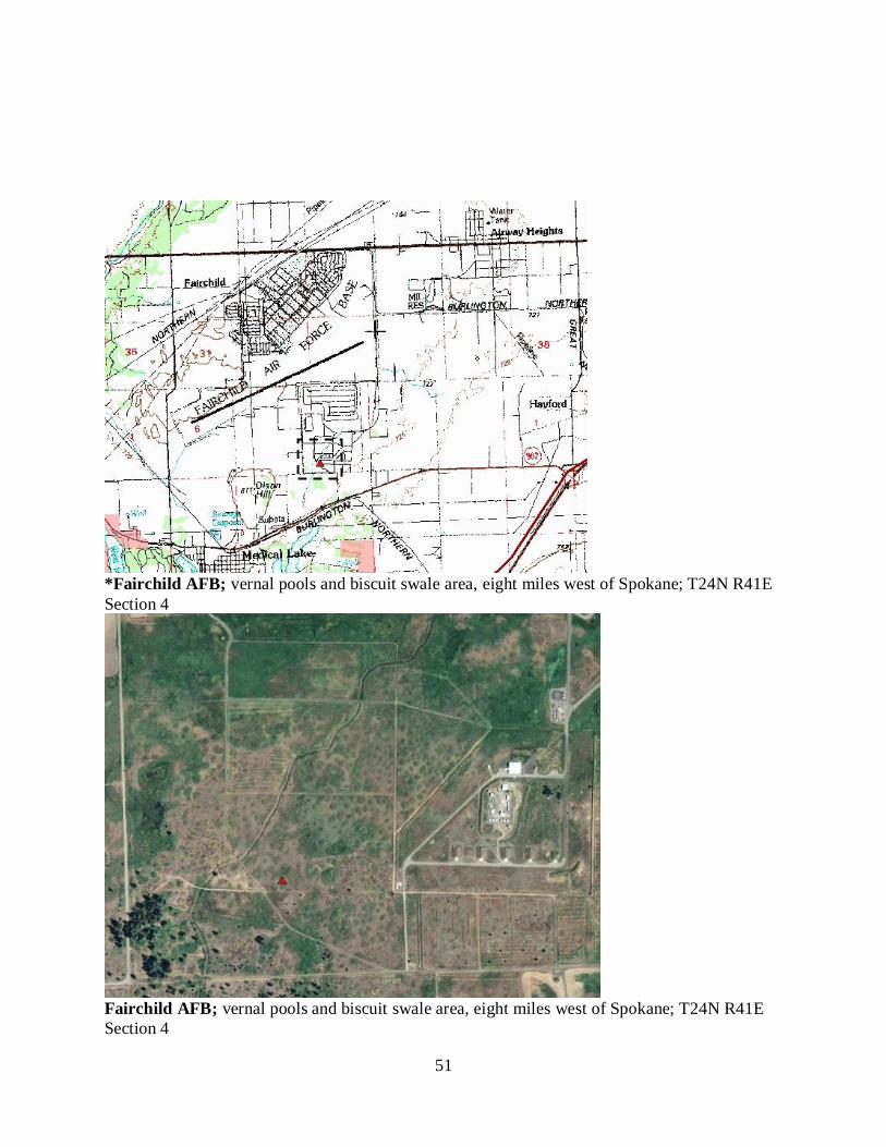
51
*Fairchild AFB; vernal pools and biscuit swale area, eight miles west of Spokane; T24N R41E
Section 4
Fairchild AFB; vernal pools and biscuit swale area, eight miles west of Spokane; T24N R41E
Section 4
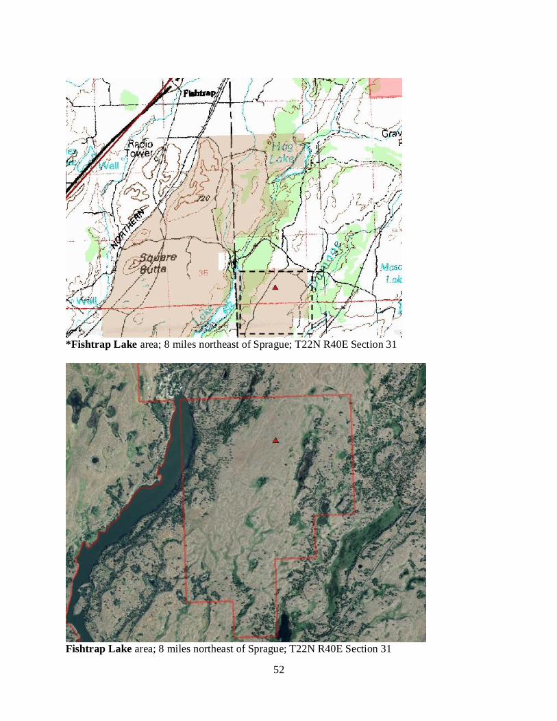
52
*Fishtrap Lake area; 8 miles northeast of Sprague; T22N R40E Section 31
Fishtrap Lake area; 8 miles northeast of Sprague; T22N R40E Section 31
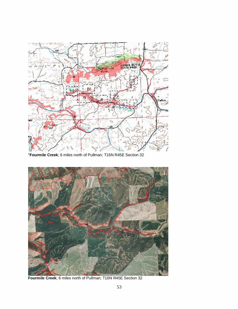
53
*Fourmile Creek; 6 miles north of Pullman; T16N R45E Section 32
Fourmile Creek; 6 miles north of Pullman; T16N R45E Section 32
1
2
3
4
5 6 7
8 9
10 11
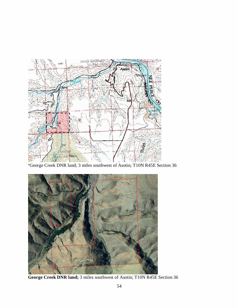
54
*George Creek DNR land; 3 miles southwest of Asotin; T10N R45E Section 36
George Creek DNR land; 3 miles southwest of Asotin; T10N R45E Section 36
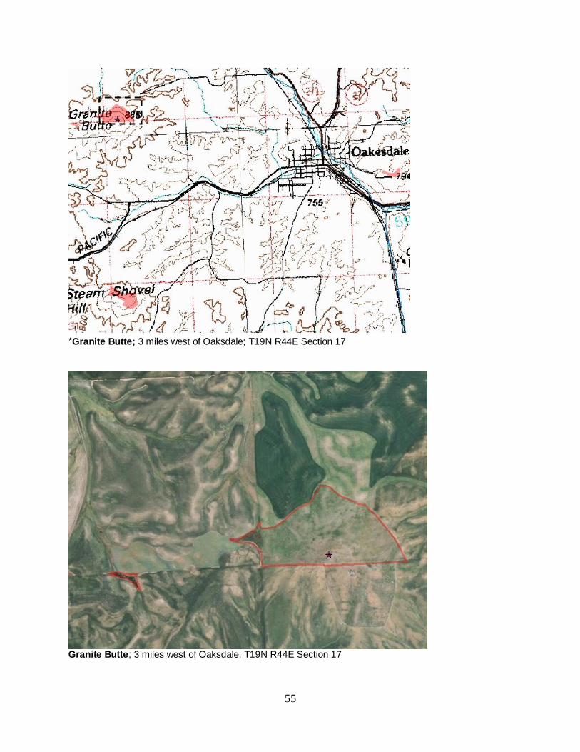
55
*Granite Butte; 3 miles west of Oaksdale; T19N R44E Section 17
Granite Butte; 3 miles west of Oaksdale; T19N R44E Section 17
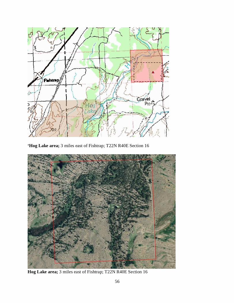
56
*Hog Lake area; 3 miles east of Fishtrap; T22N R40E Section 16
Hog Lake area; 3 miles east of Fishtrap; T22N R40E Section 16
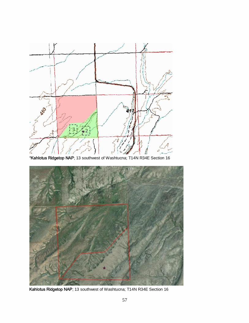
57
*Kahlotus Ridgetop NAP; 13 southwest of Washtucna; T14N R34E Section 16
Kahlotus Ridgetop NAP; 13 southwest of Washtucna; T14N R34E Section 16
2 1
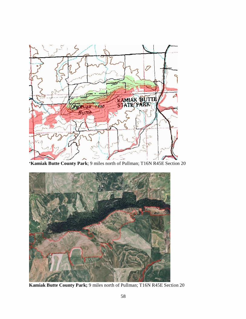
58
*Kamiak Butte County Park; 9 miles north of Pullman; T16N R45E Section 20
Kamiak Butte County Park; 9 miles north of Pullman; T16N R45E Section 20
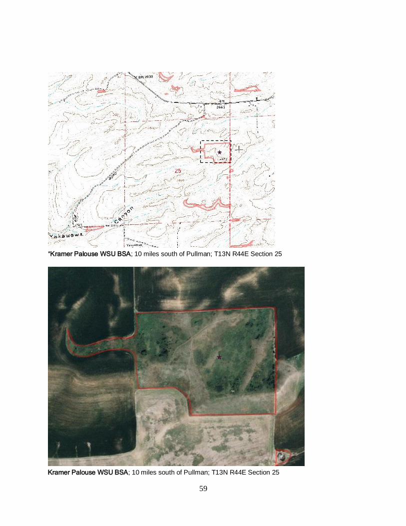
59
*Kramer Palouse WSU BSA; 10 miles south of Pullman; T13N R44E Section 25
Kramer Palouse WSU BSA; 10 miles south of Pullman; T13N R44E Section 25
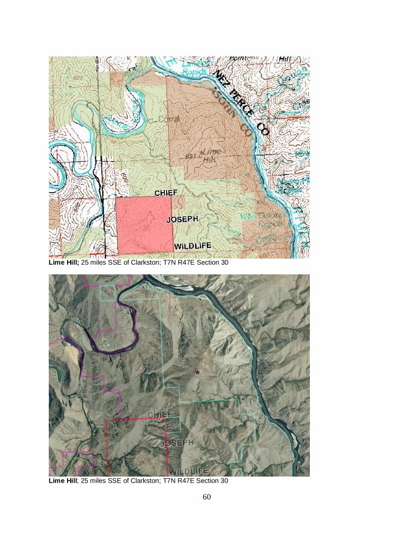
60
Lime Hill; 25 miles SSE of Clarkston; T7N R47E Section 30
Lime Hill; 25 miles SSE of Clarkston; T7N R47E Section 30
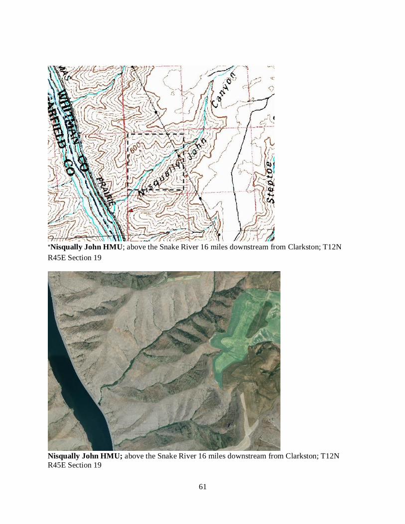
61
*Nisqually John HMU; above the Snake River 16 miles downstream from Clarkston; T12N
R45E Section 19
Nisqually John HMU; above the Snake River 16 miles downstream from Clarkston; T12N
R45E Section 19
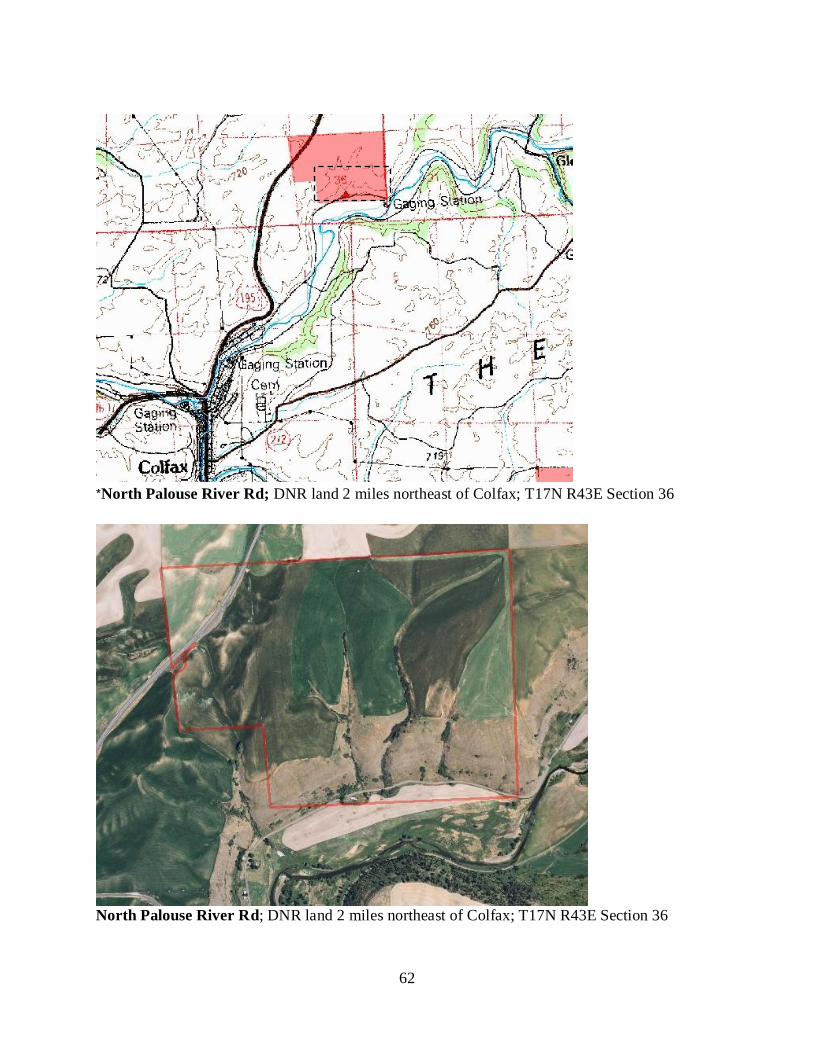
62
*North Palouse River Rd; DNR land 2 miles northeast of Colfax; T17N R43E Section 36
North Palouse River Rd; DNR land 2 miles northeast of Colfax; T17N R43E Section 36

63
North Pine; 4 miles north of Rosalia; T21N R43E Section 23
North Pine; 4 miles north of Rosalia; T21N R43E Section 23
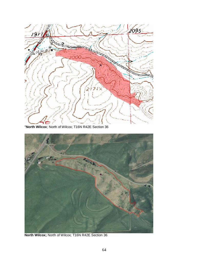
64
*North Wilcox; North of Wilcox; T16N R42E Section 36
North Wilcox; North of Wilcox; T16N R42E Section 36
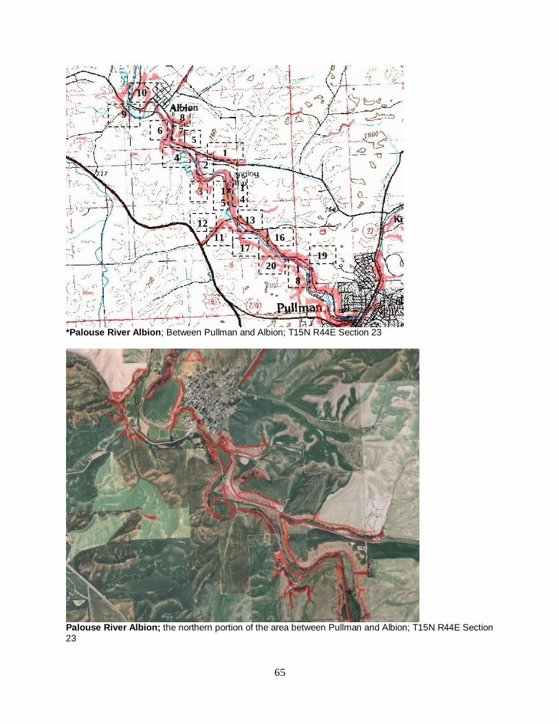
65
*Palouse River Albion; Between Pullman and Albion; T15N R44E Section 23
Palouse River Albion; the northern portion of the area between Pullman and Albion; T15N R44E Section
23
7
1 2
3
4
5
8
6
9
10
1
5
1
4
12
16
13
17 11
1
8
19 20
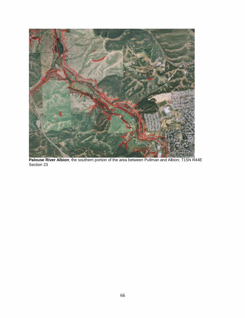
66
Palouse River Albion; the southern portion of the area between Pullman and Albion; T15N R44E
Section 23
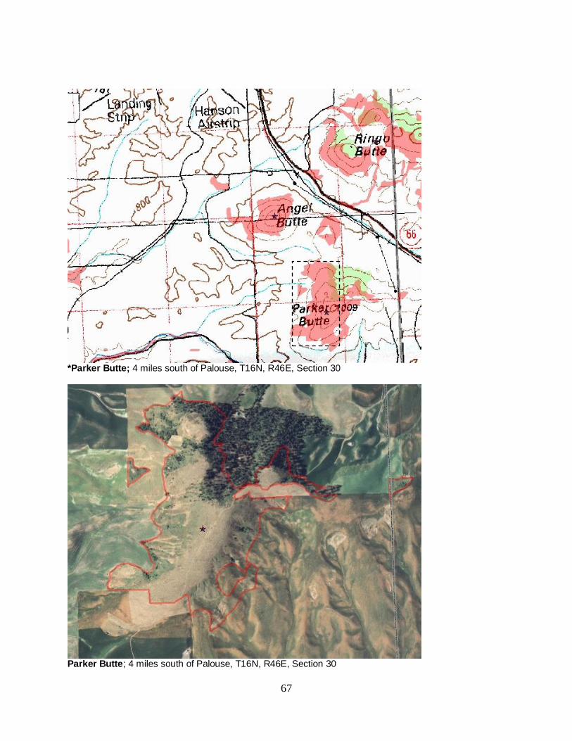
67
*Parker Butte; 4 miles south of Palouse, T16N, R46E, Section 30
Parker Butte; 4 miles south of Palouse, T16N, R46E, Section 30
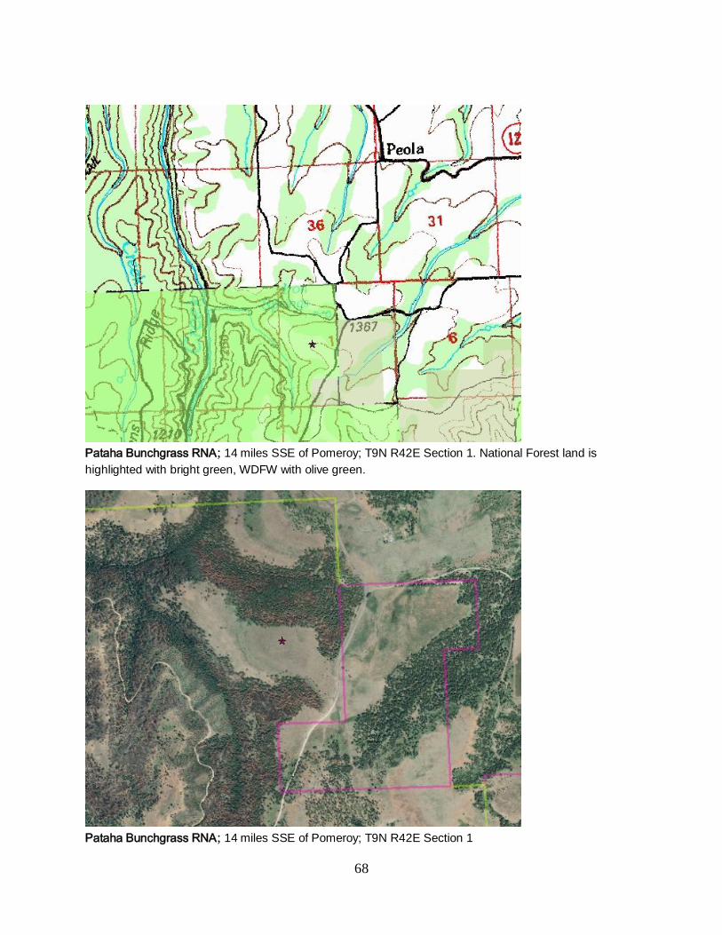
68
Pataha Bunchgrass RNA; 14 miles SSE of Pomeroy; T9N R42E Section 1. National Forest land is
highlighted with bright green, WDFW with olive green.
Pataha Bunchgrass RNA; 14 miles SSE of Pomeroy; T9N R42E Section 1
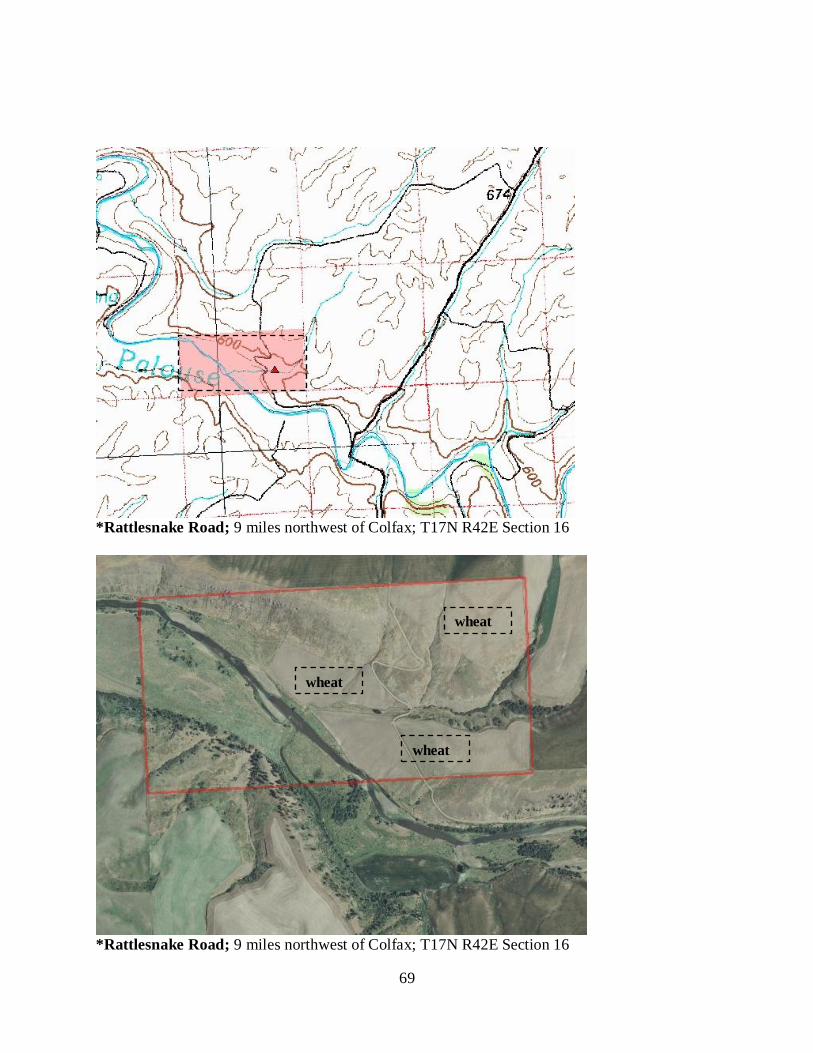
69
*Rattlesnake Road; 9 miles northwest of Colfax; T17N R42E Section 16
*Rattlesnake Road; 9 miles northwest of Colfax; T17N R42E Section 16
wheat
wheat
wheat
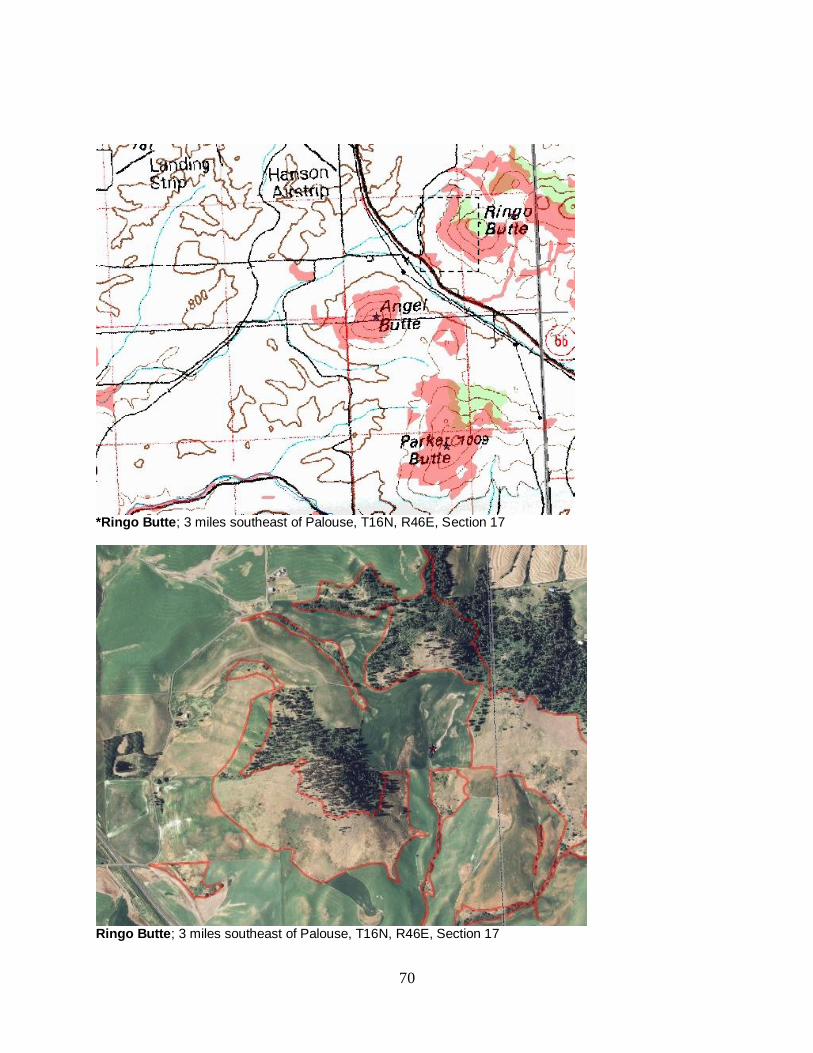
70
*Ringo Butte; 3 miles southeast of Palouse, T16N, R46E, Section 17
Ringo Butte; 3 miles southeast of Palouse, T16N, R46E, Section 17
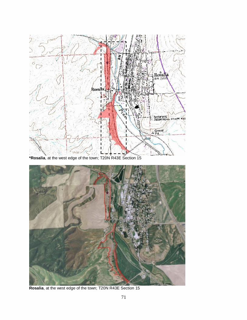
71
*Rosalia, at the west edge of the town; T20N R43E Section 15
Rosalia, at the west edge of the town; T20N R43E Section 15
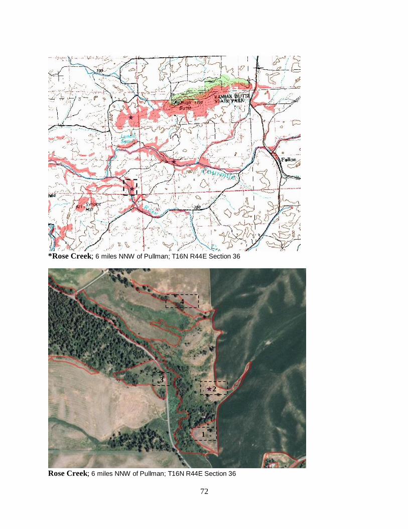
72
*Rose Creek; 6 miles NNW of Pullman; T16N R44E Section 36
Rose Creek; 6 miles NNW of Pullman; T16N R44E Section 36
1
2
3
4
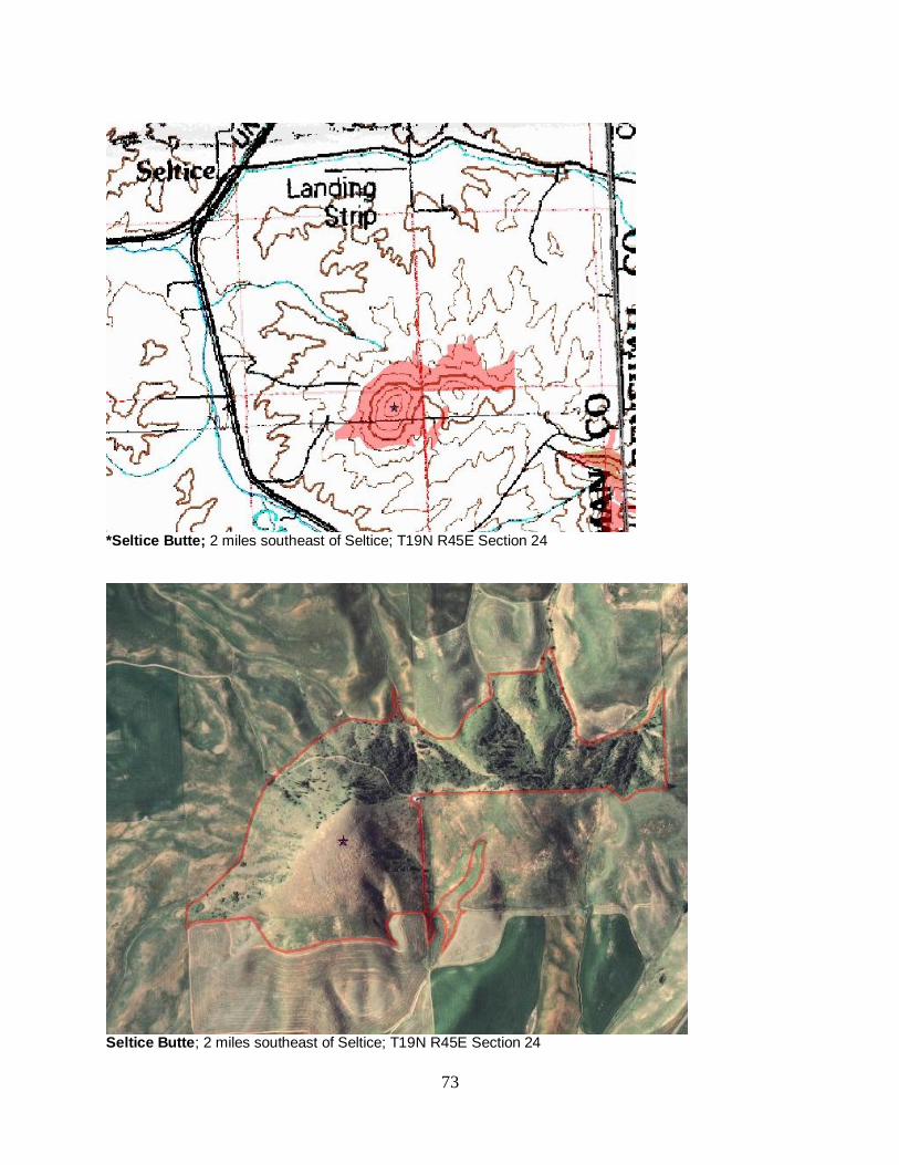
73
*Seltice Butte; 2 miles southeast of Seltice; T19N R45E Section 24
Seltice Butte; 2 miles southeast of Seltice; T19N R45E Section 24
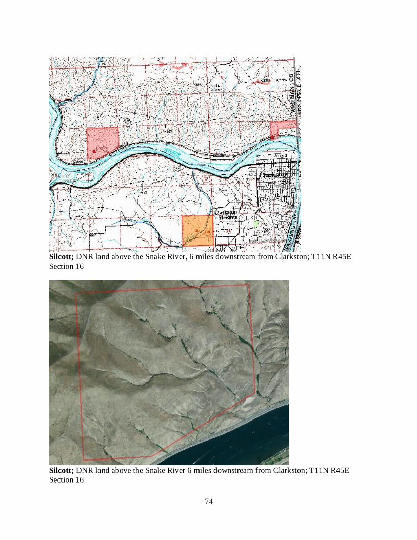
74
Silcott; DNR land above the Snake River, 6 miles downstream from Clarkston; T11N R45E
Section 16
Silcott; DNR land above the Snake River 6 miles downstream from Clarkston; T11N R45E
Section 16
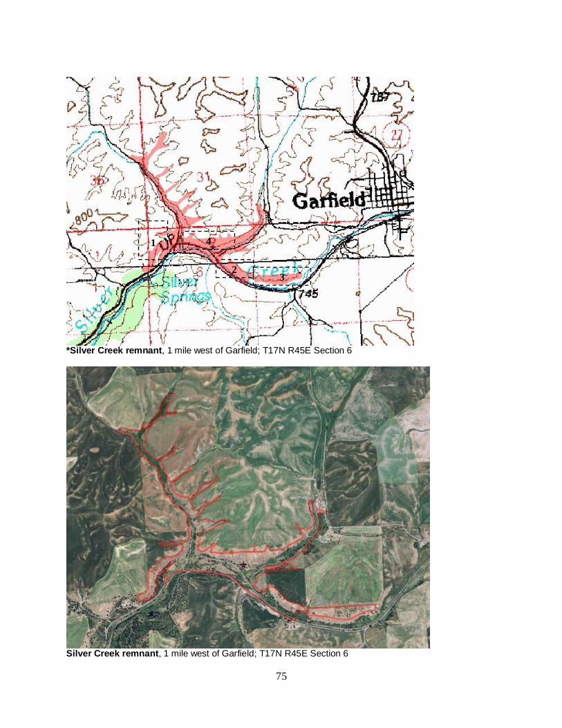
75
*Silver Creek remnant, 1 mile west of Garfield; T17N R45E Section 6
Silver Creek remnant, 1 mile west of Garfield; T17N R45E Section 6
1
2 3
4
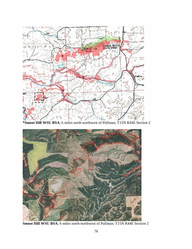
76
*Smoot Hill WSU BSA; 6 miles north-northwest of Pullman; T15N R44E Section 2
Smoot Hill WSU BSA; 6 miles north-northwest of Pullman; T15N R44E Section 2
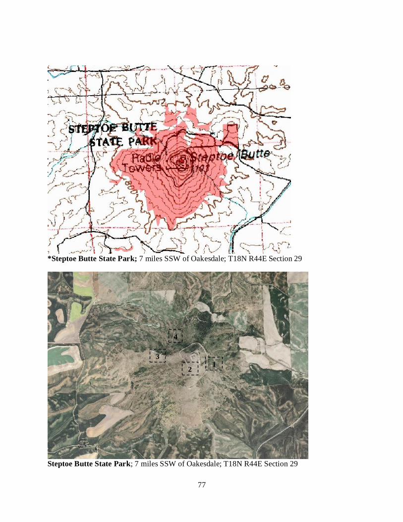
77
*Steptoe Butte State Park; 7 miles SSW of Oakesdale; T18N R44E Section 29
Steptoe Butte State Park; 7 miles SSW of Oakesdale; T18N R44E Section 29
1 2
3
4
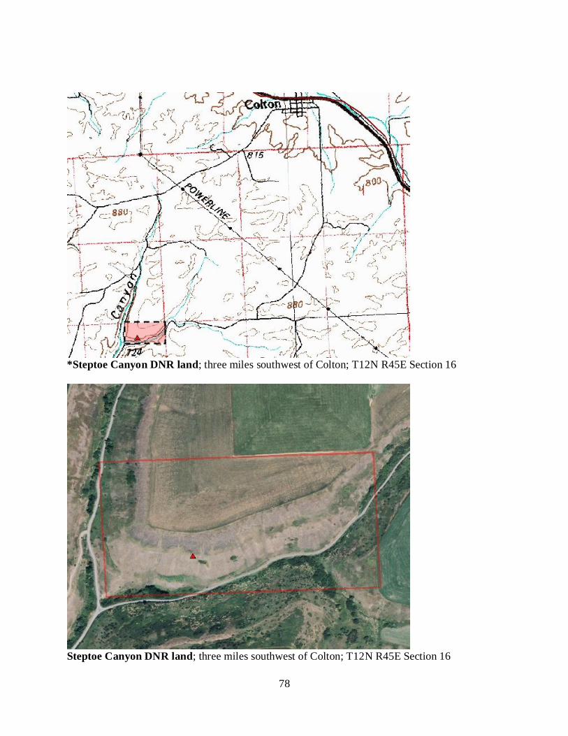
78
*Steptoe Canyon DNR land; three miles southwest of Colton; T12N R45E Section 16
Steptoe Canyon DNR land; three miles southwest of Colton; T12N R45E Section 16
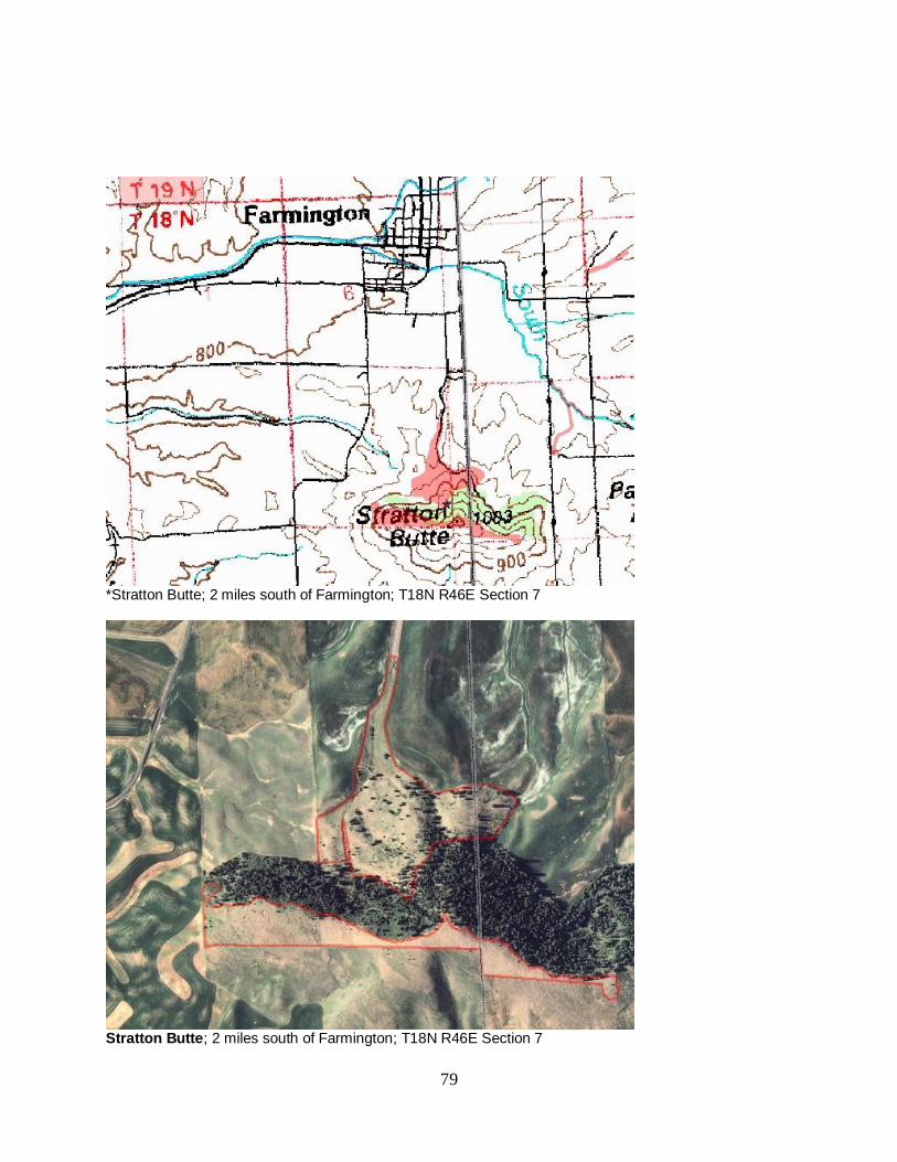
79
*Stratton Butte; 2 miles south of Farmington; T18N R46E Section 7
Stratton Butte; 2 miles south of Farmington; T18N R46E Section 7
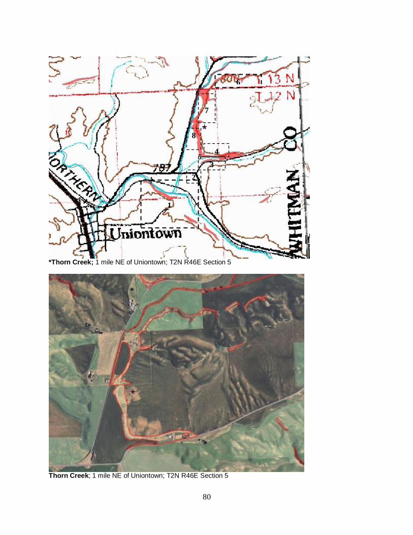
80
*Thorn Creek; 1 mile NE of Uniontown; T2N R46E Section 5
Thorn Creek; 1 mile NE of Uniontown; T2N R46E Section 5
1
2
3
4
8
7
6
5
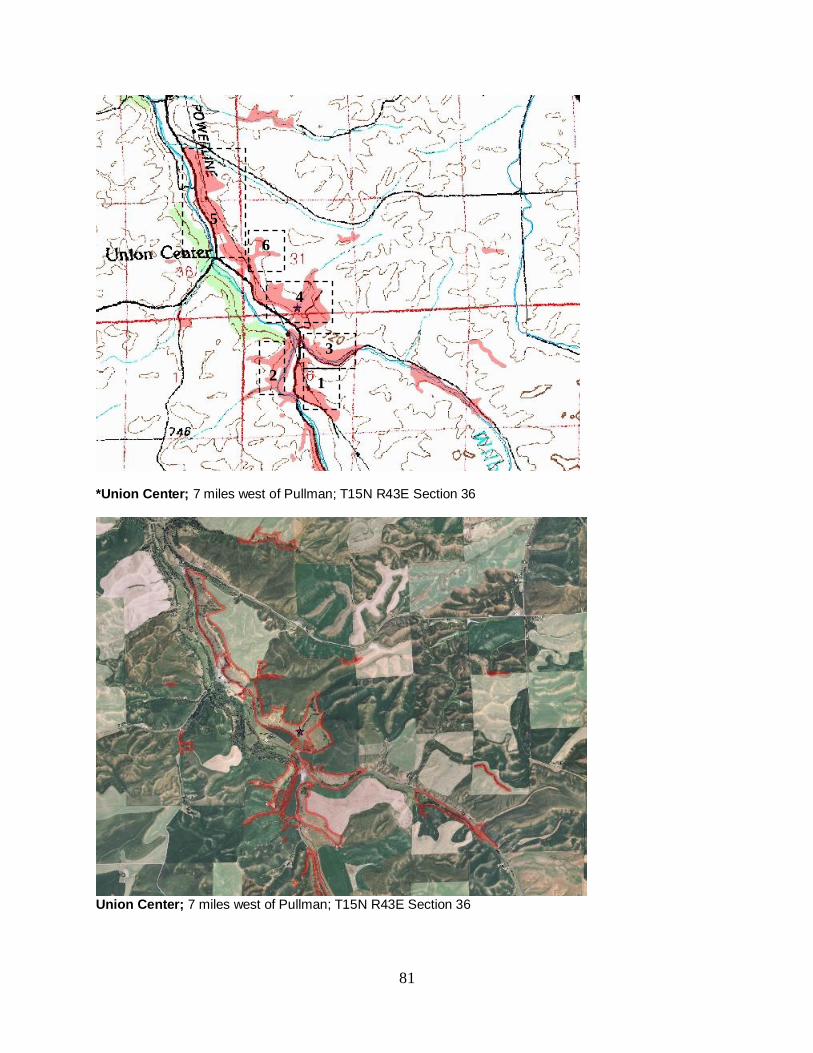
81
*Union Center; 7 miles west of Pullman; T15N R43E Section 36
Union Center; 7 miles west of Pullman; T15N R43E Section 36
2 1
3
4
5
6
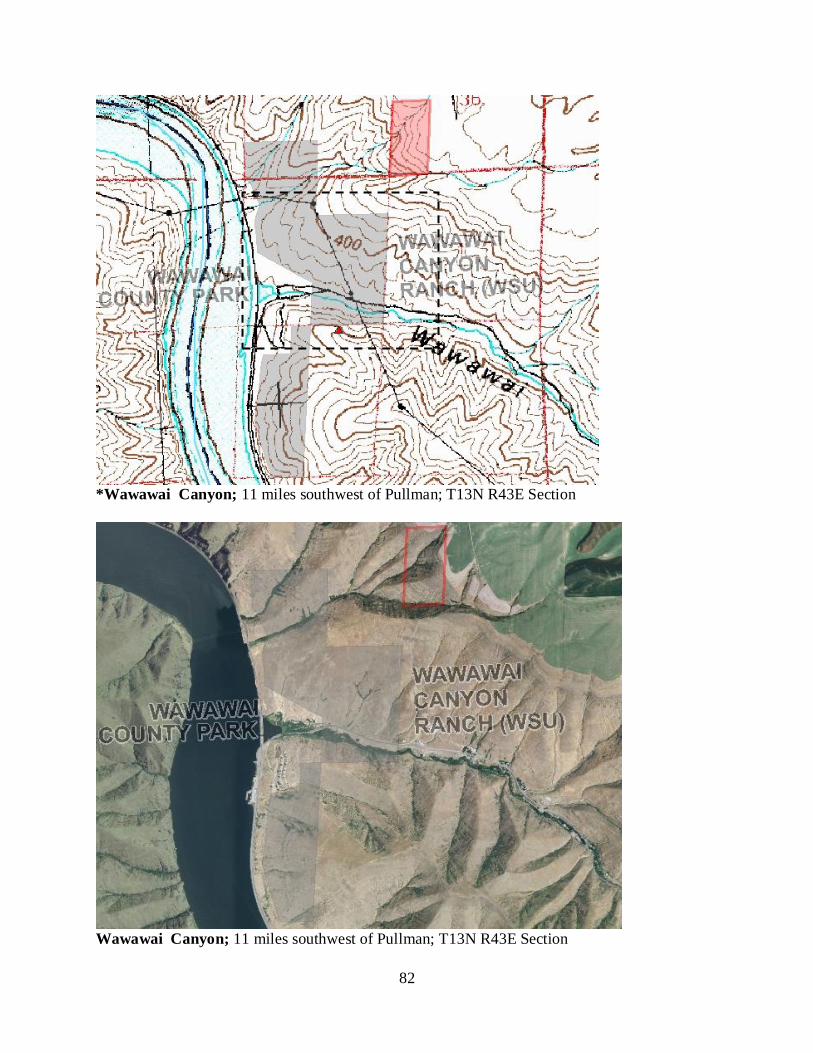
82
*Wawawai Canyon; 11 miles southwest of Pullman; T13N R43E Section
Wawawai Canyon; 11 miles southwest of Pullman; T13N R43E Section
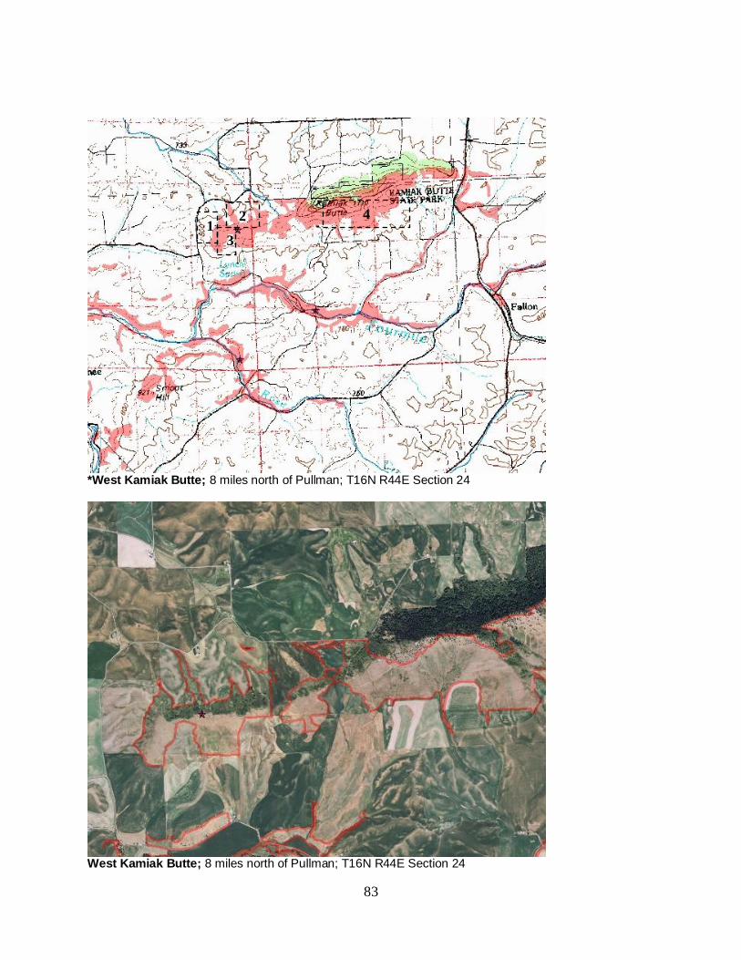
83
*West Kamiak Butte; 8 miles north of Pullman; T16N R44E Section 24
West Kamiak Butte; 8 miles north of Pullman; T16N R44E Section 24
1 2
3
4
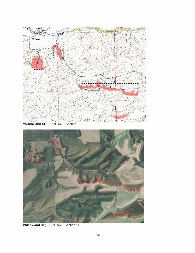
84
*Wilcox and SE; T15N R42E Section 11
Wilcox and SE; T15N R42E Section 11
1
2
3
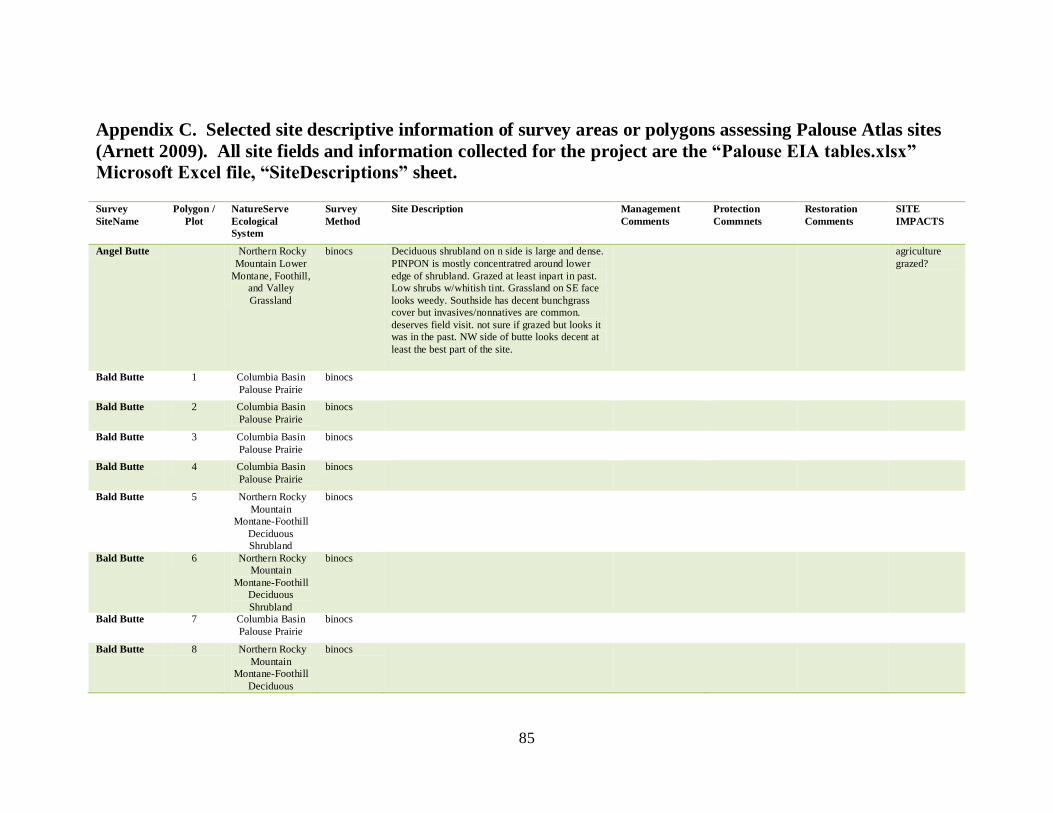
85
Appendix C. Selected site descriptive information of survey areas or polygons assessing Palouse Atlas sites
(Arnett 2009). All site fields and information collected for the project are the “Palouse EIA tables.xlsx”
Microsoft Excel file, “SiteDescriptions” sheet. Survey
SiteName
Polygon /
Plot
NatureServe
Ecological
System
Survey
Method
Site Description Management
Comments
Protection
Commnets
Restoration
Comments
SITE
IMPACTS
Angel Butte Northern Rocky
Mountain Lower
Montane, Foothill,
and Valley
Grassland
binocs Deciduous shrubland on n side is large and dense.
PINPON is mostly concentratred around lower
edge of shrubland. Grazed at least inpart in past.
Low shrubs w/whitish tint. Grassland on SE face
looks weedy. Southside has decent bunchgrass
cover but invasives/nonnatives are common.
deserves field visit. not sure if grazed but looks it
was in the past. NW side of butte looks decent at
least the best part of the site.
agriculture
grazed?
Bald Butte 1 Columbia Basin
Palouse Prairie
binocs
Bald Butte 2 Columbia Basin
Palouse Prairie
binocs
Bald Butte 3 Columbia Basin
Palouse Prairie
binocs
Bald Butte 4 Columbia Basin
Palouse Prairie
binocs
Bald Butte 5 Northern Rocky
Mountain
Montane-Foothill
Deciduous
Shrubland
binocs
Bald Butte 6 Northern Rocky
Mountain
Montane-Foothill
Deciduous
Shrubland
binocs
Bald Butte 7 Columbia Basin
Palouse Prairie
binocs
Bald Butte 8 Northern Rocky
Mountain
Montane-Foothill
Deciduous
binocs
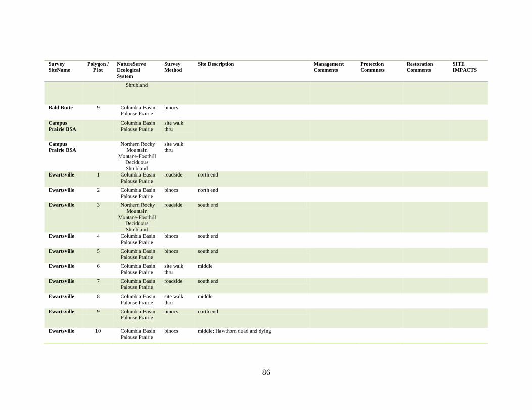
86
Survey
SiteName
Polygon /
Plot
NatureServe
Ecological
System
Survey
Method
Site Description Management
Comments
Protection
Commnets
Restoration
Comments
SITE
IMPACTS
Shrubland
Bald Butte 9 Columbia Basin
Palouse Prairie
binocs
Campus
Prairie BSA
Columbia Basin
Palouse Prairie
site walk
thru
Campus
Prairie BSA
Northern Rocky
Mountain
Montane-Foothill
Deciduous
Shrubland
site walk
thru
Ewartsville 1 Columbia Basin
Palouse Prairie
roadside north end
Ewartsville 2 Columbia Basin
Palouse Prairie
binocs north end
Ewartsville 3 Northern Rocky
Mountain
Montane-Foothill
Deciduous
Shrubland
roadside south end
Ewartsville 4 Columbia Basin
Palouse Prairie
binocs south end
Ewartsville 5 Columbia Basin
Palouse Prairie
binocs south end
Ewartsville 6 Columbia Basin
Palouse Prairie
site walk
thru
middle
Ewartsville 7 Columbia Basin
Palouse Prairie
roadside south end
Ewartsville 8 Columbia Basin
Palouse Prairie
site walk
thru
middle
Ewartsville 9 Columbia Basin
Palouse Prairie
binocs north end
Ewartsville 10 Columbia Basin
Palouse Prairie
binocs middle; Hawthorn dead and dying
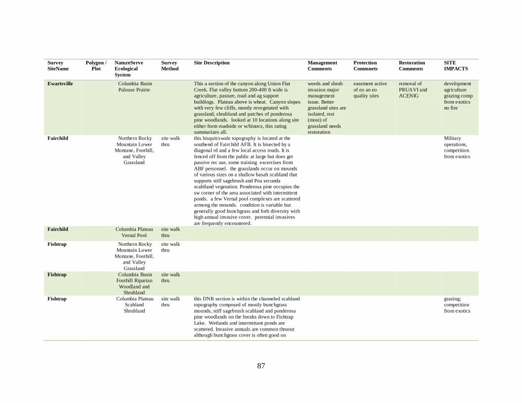
87
Survey
SiteName
Polygon /
Plot
NatureServe
Ecological
System
Survey
Method
Site Description Management
Comments
Protection
Commnets
Restoration
Comments
SITE
IMPACTS
Ewartsville Columbia Basin
Palouse Prairie
This a section of the canyon along Union Flat
Creek. Flat valley bottom 200-400 ft wide is
agriculture, pasture, road and ag support
buildings. Plateau above is wheat. Canyon slopes
with very few cliffs, mostly revegetated with
grassland, shrubland and patches of ponderosa
pine woodlands. looked at 10 locations along site
either form roadside or w/binocs, this rating
summarizes all.
weeds and shrub
invasion major
management
issue. Better
grassland sites are
isolated, rest
(most) of
grassland needs
restoration
easement active
of eo an eo
quality sites
removal of
PRUAVI and
ACENIG
development
agriculture
grazing comp
from exotics
no fire
Fairchild Northern Rocky
Mountain Lower
Montane, Foothill,
and Valley
Grassland
site walk
thru
this bisquit/swale topography is located at the
southend of Fairchild AFB. It is bisected by a
diagonal rd and a few local access roads. It is
fenced off from the public at large but does get
passive rec use, some training excercises from
ABF personnel. the grasslands occur on mounds
of various sizes on a shallow basalt scabland that
supports stiff sagebrush and Poa secunda
scablland vegetation. Ponderosa pine occupies the
sw corner of the area associated with intermittent
ponds. a few Vernal pool complexes are scattered
armong the mounds. condition is variable but
generally good bunchgrass and forb diversity with
high annual invasive cover. perennial invasives
are frequently encountered.
Military
operations,
competition
from exotics
Fairchild Columbia Plateau
Vernal Pool
site walk
thru
Fishtrap Northern Rocky
Mountain Lower
Montane, Foothill,
and Valley
Grassland
site walk
thru
Fishtrap Columbia Basin
Foothill Riparian
Woodland and
Shrubland
site walk
thru
Fishtrap Columbia Plateau
Scabland
Shrubland
site walk
thru
this DNR section is within the channeled scabland
topography composed of mostly bunchgrass
mounds, stiff sagebrush scabland and ponderosa
pine woodlands on the breaks down to Fishtrap
Lake. Wetlands and intermittant ponds are
scattered. Invasive annuals are common thruout
although bunchgrass cover is often good on
grazing;
competition
from exotics
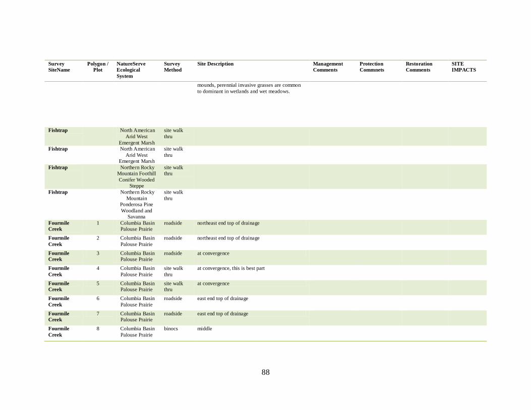
88
Survey
SiteName
Polygon /
Plot
NatureServe
Ecological
System
Survey
Method
Site Description Management
Comments
Protection
Commnets
Restoration
Comments
SITE
IMPACTS
mounds, perennial invasive grasses are common
to dominant in wetlands and wet meadows.
Fishtrap North American
Arid West
Emergent Marsh
site walk
thru
Fishtrap North American
Arid West
Emergent Marsh
site walk
thru
Fishtrap Northern Rocky
Mountain Foothill
Conifer Wooded
Steppe
site walk
thru
Fishtrap Northern Rocky
Mountain
Ponderosa Pine
Woodland and
Savanna
site walk
thru
Fourmile
Creek
1 Columbia Basin
Palouse Prairie
roadside northeast end top of drainage
Fourmile
Creek
2 Columbia Basin
Palouse Prairie
roadside northeast end top of drainage
Fourmile
Creek
3 Columbia Basin
Palouse Prairie
roadside at convergence
Fourmile
Creek
4 Columbia Basin
Palouse Prairie
site walk
thru
at convergence, this is best part
Fourmile
Creek
5 Columbia Basin
Palouse Prairie
site walk
thru
at convergence
Fourmile
Creek
6 Columbia Basin
Palouse Prairie
roadside east end top of drainage
Fourmile
Creek
7 Columbia Basin
Palouse Prairie
roadside east end top of drainage
Fourmile
Creek
8 Columbia Basin
Palouse Prairie
binocs middle
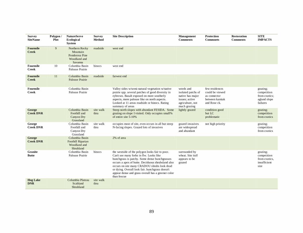
89
Survey
SiteName
Polygon /
Plot
NatureServe
Ecological
System
Survey
Method
Site Description Management
Comments
Protection
Commnets
Restoration
Comments
SITE
IMPACTS
Fourmile
Creek
9 Northern Rocky
Mountain
Ponderosa Pine
Woodland and
Savanna
roadside west end
Fourmile
Creek
10 Columbia Basin
Palouse Prairie
binocs west end
Fourmile
Creek
11 Columbia Basin
Palouse Prairie
roadside farwest end
Fourmile
Creek
Columbia Basin
Palouse Prairie
Valley sides w/semi-natural vegetation w/native
prairie spp. several patches of good diversity in
eybrows. Basalt exposed on more southerly
aspects, more palouse like on north aspects.
Looked at 11 areas roadside or binocs. Rating
summary of areas
weeds and
isolated patchs of
native has major
issues; active
agriculture, not
much grazing
few residences
could be viewed
as connector
between kamiak
and Rose ck.
grazing;
competition
from exotics;
agland slope
failures
George
Creek DNR
Columbia Basin
Foothill and
Canyon Dry
Grassland
site walk
thru
Steep north slopes with abundant FESIDA. Some
grazing on slope I visited. Only occupies small%
of entire site 5-10%
lightly grazed condition good
but LC
problematic
grazing;
competition
from exotics
George
Creek DNR
Columbia Basin
Foothill and
Canyon Dry
Grassland
site walk
thru
occupies most of site, even occurs in all but steep
N-facing slopes. Grazed lots of invasives
grazed invasives
are widespread
and abundant
not high priority grazing;
competition
from exotics
George
Creek DNR
Columbia Basin
Foothill Riparian
Woodland and
Shrubland
2% of area
Granite
Butte
Columbia Basin
Palouse Prairie
binocs the westside of the polygon looks fair to poor.
Can't see many forbs in flw. Looks like
bunchgrass is patchy. Some dense bunchgrasses
occurs a apex of butte. Deciduous shrubsland also
occurs on site many CRADOU shrubs look dead
or dying. Overall look fair. bunchgrass doesn't
appear dense and grass overall has a greener color
than fescue
surrounded by
wheat. Site itslf
appears to be
grazed
grazing;
competition
from exotics,
insufficient
size
Hog Lake
DNR
Columbia Plateau
Scabland
Shrubland
site walk
thru
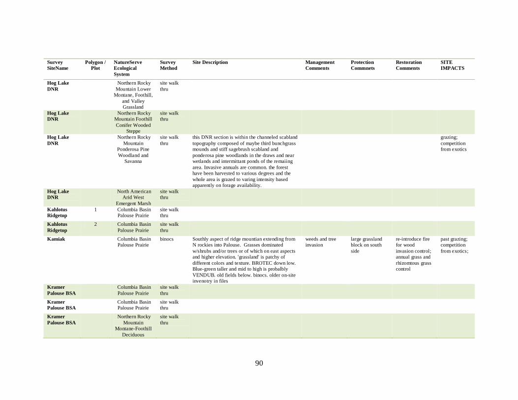
90
Survey
SiteName
Polygon /
Plot
NatureServe
Ecological
System
Survey
Method
Site Description Management
Comments
Protection
Commnets
Restoration
Comments
SITE
IMPACTS
Hog Lake
DNR
Northern Rocky
Mountain Lower
Montane, Foothill,
and Valley
Grassland
site walk
thru
Hog Lake
DNR
Northern Rocky
Mountain Foothill
Conifer Wooded
Steppe
site walk
thru
Hog Lake
DNR
Northern Rocky
Mountain
Ponderosa Pine
Woodland and
Savanna
site walk
thru
this DNR section is within the channeled scabland
topography composed of maybe third bunchgrass
mounds and stiff sagebrush scabland and
ponderosa pine woodlands in the draws and near
wetlands and intermittant ponds of the remaiing
area. Invasive annuals are common. the forest
have been harvested to various degrees and the
whole area is grazed to varing intensity based
apparently on forage availability.
grazing;
competition
from exotics
Hog Lake
DNR
North American
Arid West
Emergent Marsh
site walk
thru
Kahlotus
Ridgetop
1 Columbia Basin
Palouse Prairie
site walk
thru
Kahlotus
Ridgetop
2 Columbia Basin
Palouse Prairie
site walk
thru
Kamiak Columbia Basin
Palouse Prairie
binocs Southly aspect of ridge mountian extending from
N rockies into Palouse. Grasses dominated
w/shrubs and/or trees or of which on east aspects
and higher elevation. 'grassland' is patchy of
different colors and texture. BROTEC down low.
Blue-green taller and mid to high is probalbly
VENDUB. old fields below. binocs. older on-site
invenotry in files
weeds and tree
invasion
large grassland
block on south
side
re-introduce fire
for wood
invasion control;
annual grass and
rhizomtous grass
control
past grazing;
competition
from exotics;
Kramer
Palouse BSA
Columbia Basin
Palouse Prairie
site walk
thru
Kramer
Palouse BSA
Columbia Basin
Palouse Prairie
site walk
thru
Kramer
Palouse BSA
Northern Rocky
Mountain
Montane-Foothill
Deciduous
site walk
thru
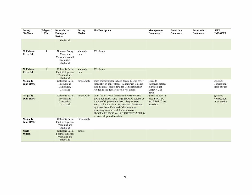
91
Survey
SiteName
Polygon /
Plot
NatureServe
Ecological
System
Survey
Method
Site Description Management
Comments
Protection
Commnets
Restoration
Comments
SITE
IMPACTS
Shrubland
N. Palouse
River Rd
1 Northern Rocky
Mountain
Montane-Foothill
Deciduous
Shrubland
site walk
thru
5% of area
N. Palouse
River Rd
2 Columbia Basin
Foothill Riparian
Woodland and
Shrubland
site walk
thru
5% of area
Nisqually
John HMU
Columbia Basin
Foothill and
Canyon Dry
Grassland
binocs/walk north northwest slopes have decent Fescue cover
especially on upper slopes. Rabbitbrush is dense
in some areas. Shrub garlands Celtis reticulata?
Are found in a few areas on lower slopes
Grazed?
Invasives patches
& invasionof
CHRNAU an
issue
grazing;
competition
from exotics
Nisqually
John HMU
Columbia Basin
Foothill and
Canyon Dry
Grassland
binocs/walk south facing slopes dominated by PSSP/POSE.
BRTE abundant. Some large BRORIG patches at
bottom of slope near trailhead. Seep emerges
along trail at toe slope. Riparian area dominated
by Alnus rhombifolia and Celtis reticulata
understory covered with Rubus discolor.
SPOCRY/POASEC lots of BROTEC POABUL is
on lower slope and benches.
grazed at least in
past. BROTEC
and BRORIG are
abundant
grazing;
competition
from exotics
Nisqually
John HMU
Columbia Basin
Foothill Riparian
Woodland and
Shrubland
binocs/walk
North
Wilcox
Columbia Basin
Foothill Riparian
Woodland and
Shrubland
binocs
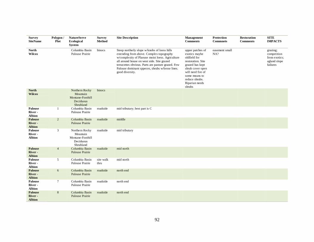
92
Survey
SiteName
Polygon /
Plot
NatureServe
Ecological
System
Survey
Method
Site Description Management
Comments
Protection
Commnets
Restoration
Comments
SITE
IMPACTS
North
Wilcox
Columbia Basin
Palouse Prairie
binocs Steep northerly slope w/knobs of loess hills
extending from above. Complex topography
w/complexity of Plaouse moist loess. Agriculture
all around house on west side. Site grazed
terracettes obvious. Parts are pasture grazed. Few
Palouse dominant sppeces, shrubs w/brose lines.
good diversity.
upper patches of
exotics maybe
oldfield for
restoration. Site
grazed has kept
shrub cover open
will need fire of
some means to
reduce shrubs.
Riparian needs
shrubs
easement small
NA?
grazing;
competition
from exotics;
agland slope
failures
North
Wilcox
Northern Rocky
Mountain
Montane-Foothill
Deciduous
Shrubland
binocs
Palouse
River -
Albion
1 Columbia Basin
Palouse Prairie
roadside mid tributary; best part is C
Palouse
River -
Albion
2 Columbia Basin
Palouse Prairie
roadside middle
Palouse
River -
Albion
3 Northern Rocky
Mountain
Montane-Foothill
Deciduous
Shrubland
roadside mid tributary
Palouse
River -
Albion
4 Columbia Basin
Palouse Prairie
roadside mid north
Palouse
River -
Albion
5 Columbia Basin
Palouse Prairie
site walk
thru
mid north
Palouse
River -
Albion
6 Columbia Basin
Palouse Prairie
roadside north end
Palouse
River -
Albion
7 Columbia Basin
Palouse Prairie
roadside north end
Palouse
River -
Albion
8 Columbia Basin
Palouse Prairie
roadside north end
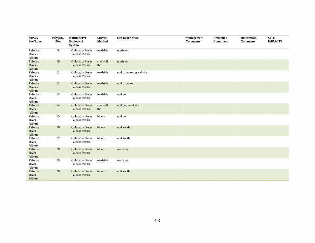
93
Survey
SiteName
Polygon /
Plot
NatureServe
Ecological
System
Survey
Method
Site Description Management
Comments
Protection
Commnets
Restoration
Comments
SITE
IMPACTS
Palouse
River -
Albion
9 Columbia Basin
Palouse Prairie
roadside north end
Palouse
River -
Albion
10 Columbia Basin
Palouse Prairie
site walk
thru
north end
Palouse
River -
Albion
11 Columbia Basin
Palouse Prairie
roadside mid tributary; good site
Palouse
River -
Albion
12 Columbia Basin
Palouse Prairie
roadside mid tributary
Palouse
River -
Albion
13 Columbia Basin
Palouse Prairie
roadside middle
Palouse
River -
Albion
14 Columbia Basin
Palouse Prairie
site walk
thru
middle; good site
Palouse
River -
Albion
15 Columbia Basin
Palouse Prairie
binocs middle
Palouse
River -
Albion
16 Columbia Basin
Palouse Prairie
binocs mid south
Palouse
River -
Albion
17 Columbia Basin
Palouse Prairie
binocs mid south
Palouse
River -
Albion
18 Columbia Basin
Palouse Prairie
binocs south end
Palouse
River -
Albion
19 Columbia Basin
Palouse Prairie
roadside south end
Palouse
River -
Albion
20 Columbia Basin
Palouse Prairie
binocs mid south
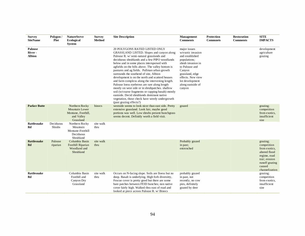
94
Survey
SiteName
Polygon /
Plot
NatureServe
Ecological
System
Survey
Method
Site Description Management
Comments
Protection
Commnets
Restoration
Comments
SITE
IMPACTS
Palouse
River -
Albion
20 POLYGONS RATED LISTED ONLY
GRASSLAND LISTED. Slopes and canyon along
Palouse R. w/ semi-natural grasslands and
deciduous shrublands and a few PIPO woodlands
below and in some places interspersed with
agfields on the hills above. The valley bottom is
pastures and ag fields. Pullman urban growth
surrounds the southend of site, Albion
development is on the north and scatterd houses
and farm complexs along the intervening length.
Palouse loess eyebrows are rare along length
mostly on west side or in shrubpatches. shallow
soil (w/coarse fragments or capping basalt) mostly
eastside. Decid shrublands dominant native
vegetation, those check have weedy undergrowth
(past grazing effects?)
major issues
w/exotic invasion
and established
populations;
shrub invasion in
to Palouse and
Canyon
grassland, edge
effects. New view
lot development
along eastside of
canyon
development
agriculture
grazing
Parker Butte Northern Rocky
Mountain Lower
Montane, Foothill,
and Valley
Grassland
binocs westside seems to look nicer than east side. Pretty
extensive grassland. Look fair, maybe good
portions was well. Low shrubs present bunchgrass
seems decent. Definitly worth a field visit.
grazed grazing;
competition
from exotics,
insufficient
size
Rattlesnake
Rd
Deciduous
Shrubs
Northern Rocky
Mountain
Montane-Foothill
Deciduous
Shrubland
site walk
thru
Rattlesnake
Rd
Palouse
riparian
Columbia Basin
Foothill Riparian
Woodland and
Shrubland
site walk
thru
Probably grazed
in past;
entrenched
grazing;
competition
from exotics,
altered flood
regime, road
trai/, erosion
runoff grazing
caused
channelization
Rattlesnake
Rd
Columbia Basin
Foothill and
Canyon Dry
Grassland
site walk
thru
Occurs on N-facing slope. Soils are lloess but no
deep. Basalt is underlying. High forb diversitty,
Fescue cover is pretty good but there are some
bare patches between FEID bunches; non native
cover fairly high. Walked thru east of road and
looked at piece acroos Palouse R. w/ Binocs
probably grazed
in past, not
recently, no cow
pies, definitely
grazed by deer
grazing;
competition
from exotics,
insufficient
size
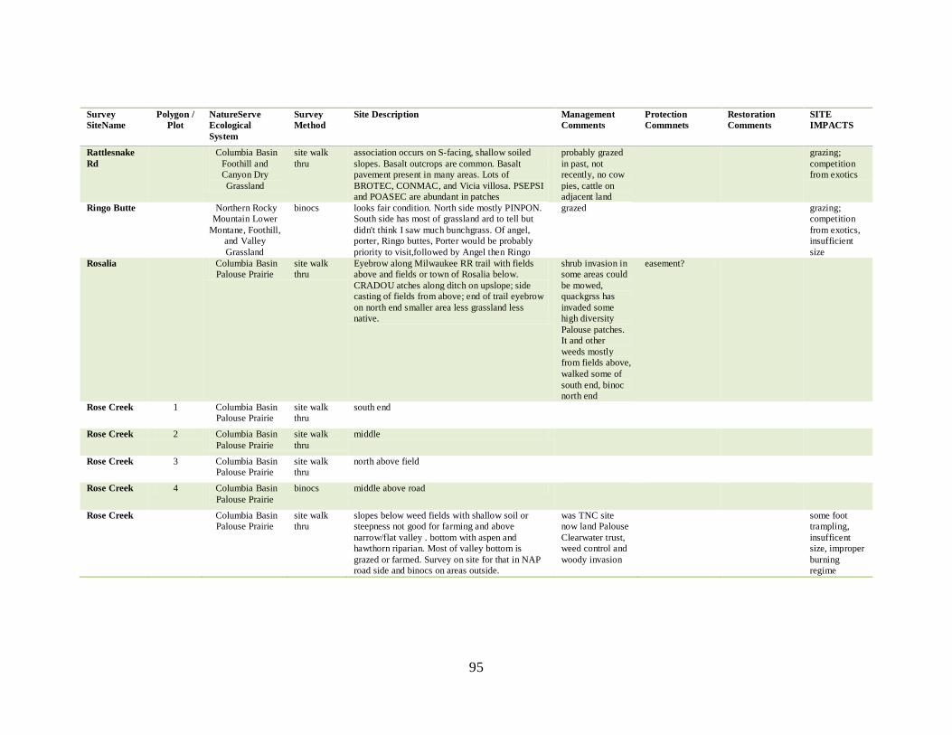
95
Survey
SiteName
Polygon /
Plot
NatureServe
Ecological
System
Survey
Method
Site Description Management
Comments
Protection
Commnets
Restoration
Comments
SITE
IMPACTS
Rattlesnake
Rd
Columbia Basin
Foothill and
Canyon Dry
Grassland
site walk
thru
association occurs on S-facing, shallow soiled
slopes. Basalt outcrops are common. Basalt
pavement present in many areas. Lots of
BROTEC, CONMAC, and Vicia villosa. PSEPSI
and POASEC are abundant in patches
probably grazed
in past, not
recently, no cow
pies, cattle on
adjacent land
grazing;
competition
from exotics
Ringo Butte Northern Rocky
Mountain Lower
Montane, Foothill,
and Valley
Grassland
binocs looks fair condition. North side mostly PINPON.
South side has most of grassland ard to tell but
didn't think I saw much bunchgrass. Of angel,
porter, Ringo buttes, Porter would be probably
priority to visit,followed by Angel then Ringo
grazed grazing;
competition
from exotics,
insufficient
size
Rosalia Columbia Basin
Palouse Prairie
site walk
thru
Eyebrow along Milwaukee RR trail with fields
above and fields or town of Rosalia below.
CRADOU atches along ditch on upslope; side
casting of fields from above; end of trail eyebrow
on north end smaller area less grassland less
native.
shrub invasion in
some areas could
be mowed,
quackgrss has
invaded some
high diversity
Palouse patches.
It and other
weeds mostly
from fields above,
walked some of
south end, binoc
north end
easement?
Rose Creek 1 Columbia Basin
Palouse Prairie
site walk
thru
south end
Rose Creek 2 Columbia Basin
Palouse Prairie
site walk
thru
middle
Rose Creek 3 Columbia Basin
Palouse Prairie
site walk
thru
north above field
Rose Creek 4 Columbia Basin
Palouse Prairie
binocs middle above road
Rose Creek Columbia Basin
Palouse Prairie
site walk
thru
slopes below weed fields with shallow soil or
steepness not good for farming and above
narrow/flat valley . bottom with aspen and
hawthorn riparian. Most of valley bottom is
grazed or farmed. Survey on site for that in NAP
road side and binocs on areas outside.
was TNC site
now land Palouse
Clearwater trust,
weed control and
woody invasion
some foot
trampling,
insufficent
size, improper
burning
regime
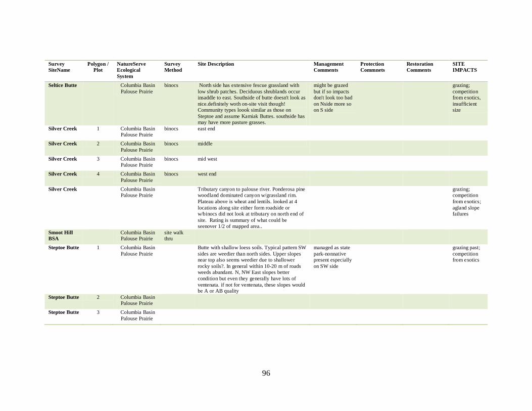
96
Survey
SiteName
Polygon /
Plot
NatureServe
Ecological
System
Survey
Method
Site Description Management
Comments
Protection
Commnets
Restoration
Comments
SITE
IMPACTS
Seltice Butte Columbia Basin
Palouse Prairie
binocs North side has extensive fescue grassland with
low shrub patches. Deciduous shrublands occur
insaddle to east. Southside of butte doesn't look as
nice.definitely woth on-site visit though!
Community types loook similar as those on
Steptoe and assume Kamiak Buttes. southside has
may have more pasture grasses.
might be grazed
but if so impacts
don't look too bad
on Nside more so
on S side
grazing;
competition
from exotics,
insufficient
size
Silver Creek 1 Columbia Basin
Palouse Prairie
binocs east end
Silver Creek 2 Columbia Basin
Palouse Prairie
binocs middle
Silver Creek 3 Columbia Basin
Palouse Prairie
binocs mid west
Silver Creek 4 Columbia Basin
Palouse Prairie
binocs west end
Silver Creek Columbia Basin
Palouse Prairie
Tributary canyon to palouse river. Ponderosa pine
woodland dominated canyon w/grassland rim.
Plateau above is wheat and lentils. looked at 4
locations along site either form roadside or
w/binocs did not look at tributary on north end of
site. Rating is summary of what could be
seenover 1/2 of mapped area..
grazing;
competition
from exotics;
agland slope
failures
Smoot Hill
BSA
Columbia Basin
Palouse Prairie
site walk
thru
Steptoe Butte 1 Columbia Basin
Palouse Prairie
Butte with shallow loess soils. Typical pattern SW
sides are weedier than north sides. Upper slopes
near top also seems weedier due to shallower
rocky soils?. In general within 10-20 m of roads
weeds abundant. N, NW East slopes better
condition but even they generally have lots of
ventenata. if not for ventenata, these slopes would
be A or AB quality
managed as state
park-nonnative
present especially
on SW side
grazing past;
competition
from exotics
Steptoe Butte 2 Columbia Basin
Palouse Prairie
Steptoe Butte 3 Columbia Basin
Palouse Prairie
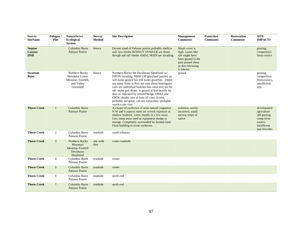
97
Survey
SiteName
Polygon /
Plot
NatureServe
Ecological
System
Survey
Method
Site Description Management
Comments
Protection
Commnets
Restoration
Comments
SITE
IMPACTS
Steptoe
Canyon
DNR
Columbia Basin
Palouse Prairie
binocs Decent stand of Palouse prairie probably shallow
soil. low shrubs ROSNUT SYMALB are dense
though and tall shrubs AMAL HODI are invading
Shrub cover is
high. Looks like
site might have
been grazed in the
past pruned shrus
or deer browsing
is intense
grazing;
competition
from exotics
Strattum
Butte
Northern Rocky
Mountain Lower
Montane, Foothill,
and Valley
Grassland
binocs Northern Rocky Mt Deciduous Shrubland w/
PIPON invading. NRM LM grassland patches as
will looks grazed but still looks good/fair. Didn't
see many forbs in flwr not sure about bunchgrass
can't see individual bunches but color isn't too far
off- mybe just dense. is grazed at leat heavily by
deer as indicated by pruned/hedge AMAL ans
CRDo shrubs. saw at least 10 cows in area.
probably not great. can see terracettes- probably
worth a site visit
grazed grazing;
competition
from exotics,
insufficient
size
Thorn Creek 1 Columbia Basin
Palouse Prairie
A cluster of eyebrows of semi-natural vegetaton
N W and S aspects most are w/rock exposure or
shallow bedrock. Loess mantle in a few areas.
Less steep areas used as equipment dumpt or
storage. Completely surrounded by farmed land.
Farm building in some eyebrows.
isolation, weedy
invasives, small
narrow strips of
native
development
agriculture
old grazing
comp form
exotics
insufficent
size biocides
Thorn Creek 2 Columbia Basin
Palouse Prairie
roadside south tributary
Thorn Creek 3 Northern Rocky
Mountain
Montane-Foothill
Deciduous
Shrubland
site walk
thru
center roadside
Thorn Creek 4 Columbia Basin
Palouse Prairie
roadside center
Thorn Creek 5 Columbia Basin
Palouse Prairie
roadside center
Thorn Creek 6 Columbia Basin
Palouse Prairie
roadside north end
Thorn Creek 7 Columbia Basin
Palouse Prairie
roadside north end
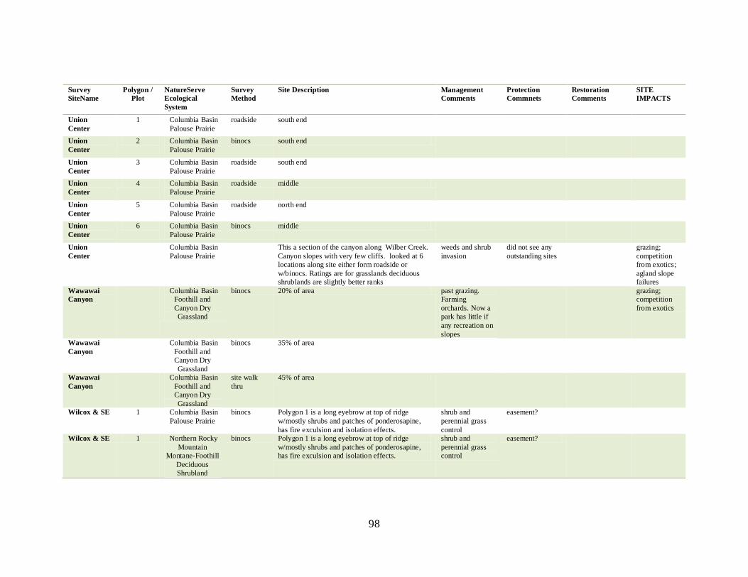
98
Survey
SiteName
Polygon /
Plot
NatureServe
Ecological
System
Survey
Method
Site Description Management
Comments
Protection
Commnets
Restoration
Comments
SITE
IMPACTS
Union
Center
1 Columbia Basin
Palouse Prairie
roadside south end
Union
Center
2 Columbia Basin
Palouse Prairie
binocs south end
Union
Center
3 Columbia Basin
Palouse Prairie
roadside south end
Union
Center
4 Columbia Basin
Palouse Prairie
roadside middle
Union
Center
5 Columbia Basin
Palouse Prairie
roadside north end
Union
Center
6 Columbia Basin
Palouse Prairie
binocs middle
Union
Center
Columbia Basin
Palouse Prairie
This a section of the canyon along Wilber Creek.
Canyon slopes with very few cliffs. looked at 6
locations along site either form roadside or
w/binocs. Ratings are for grasslands deciduous
shrublands are slightly better ranks
weeds and shrub
invasion
did not see any
outstanding sites
grazing;
competition
from exotics;
agland slope
failures
Wawawai
Canyon
Columbia Basin
Foothill and
Canyon Dry
Grassland
binocs 20% of area past grazing.
Farming
orchards. Now a
park has little if
any recreation on
slopes
grazing;
competition
from exotics
Wawawai
Canyon
Columbia Basin
Foothill and
Canyon Dry
Grassland
binocs 35% of area
Wawawai
Canyon
Columbia Basin
Foothill and
Canyon Dry
Grassland
site walk
thru
45% of area
Wilcox & SE 1 Columbia Basin
Palouse Prairie
binocs Polygon 1 is a long eyebrow at top of ridge
w/mostly shrubs and patches of ponderosapine,
has fire exculsion and isolation effects.
shrub and
perennial grass
control
easement?
Wilcox & SE 1 Northern Rocky
Mountain
Montane-Foothill
Deciduous
Shrubland
binocs Polygon 1 is a long eyebrow at top of ridge
w/mostly shrubs and patches of ponderosapine,
has fire exculsion and isolation effects.
shrub and
perennial grass
control
easement?
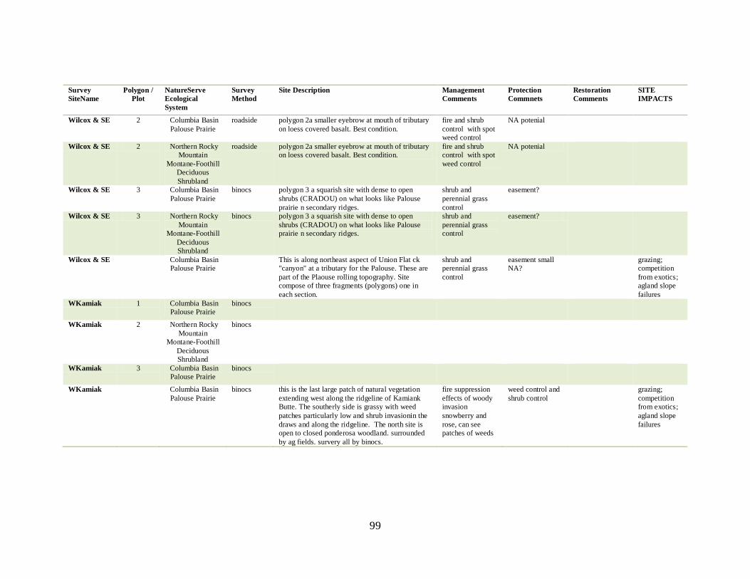
99
Survey
SiteName
Polygon /
Plot
NatureServe
Ecological
System
Survey
Method
Site Description Management
Comments
Protection
Commnets
Restoration
Comments
SITE
IMPACTS
Wilcox & SE 2 Columbia Basin
Palouse Prairie
roadside polygon 2a smaller eyebrow at mouth of tributary
on loess covered basalt. Best condition.
fire and shrub
control with spot
weed control
NA potenial
Wilcox & SE 2 Northern Rocky
Mountain
Montane-Foothill
Deciduous
Shrubland
roadside polygon 2a smaller eyebrow at mouth of tributary
on loess covered basalt. Best condition.
fire and shrub
control with spot
weed control
NA potenial
Wilcox & SE 3 Columbia Basin
Palouse Prairie
binocs polygon 3 a squarish site with dense to open
shrubs (CRADOU) on what looks like Palouse
prairie n secondary ridges.
shrub and
perennial grass
control
easement?
Wilcox & SE 3 Northern Rocky
Mountain
Montane-Foothill
Deciduous
Shrubland
binocs polygon 3 a squarish site with dense to open
shrubs (CRADOU) on what looks like Palouse
prairie n secondary ridges.
shrub and
perennial grass
control
easement?
Wilcox & SE Columbia Basin
Palouse Prairie
This is along northeast aspect of Union Flat ck
"canyon" at a tributary for the Palouse. These are
part of the Plaouse rolling topography. Site
compose of three fragments (polygons) one in
each section.
shrub and
perennial grass
control
easement small
NA?
grazing;
competition
from exotics;
agland slope
failures
WKamiak 1 Columbia Basin
Palouse Prairie
binocs
WKamiak 2 Northern Rocky
Mountain
Montane-Foothill
Deciduous
Shrubland
binocs
WKamiak 3 Columbia Basin
Palouse Prairie
binocs
WKamiak Columbia Basin
Palouse Prairie
binocs this is the last large patch of natural vegetation
extending west along the ridgeline of Kamiank
Butte. The southerly side is grassy with weed
patches particularly low and shrub invasionin the
draws and along the ridgeline. The north site is
open to closed ponderosa woodland. surrounded
by ag fields. survery all by binocs.
fire suppression
effects of woody
invasion
snowberry and
rose, can see
patches of weeds
weed control and
shrub control
grazing;
competition
from exotics;
agland slope
failures