Embed Size (px)
Citation preview

Natural Heritage Parks Plan Marion County Department of Public Works April 2010
"Wallamette" by Henry Warre, 1845. Showing oak savanna, with forested areas along waterways and in the distance. (Boyd, 1999.)

2
3
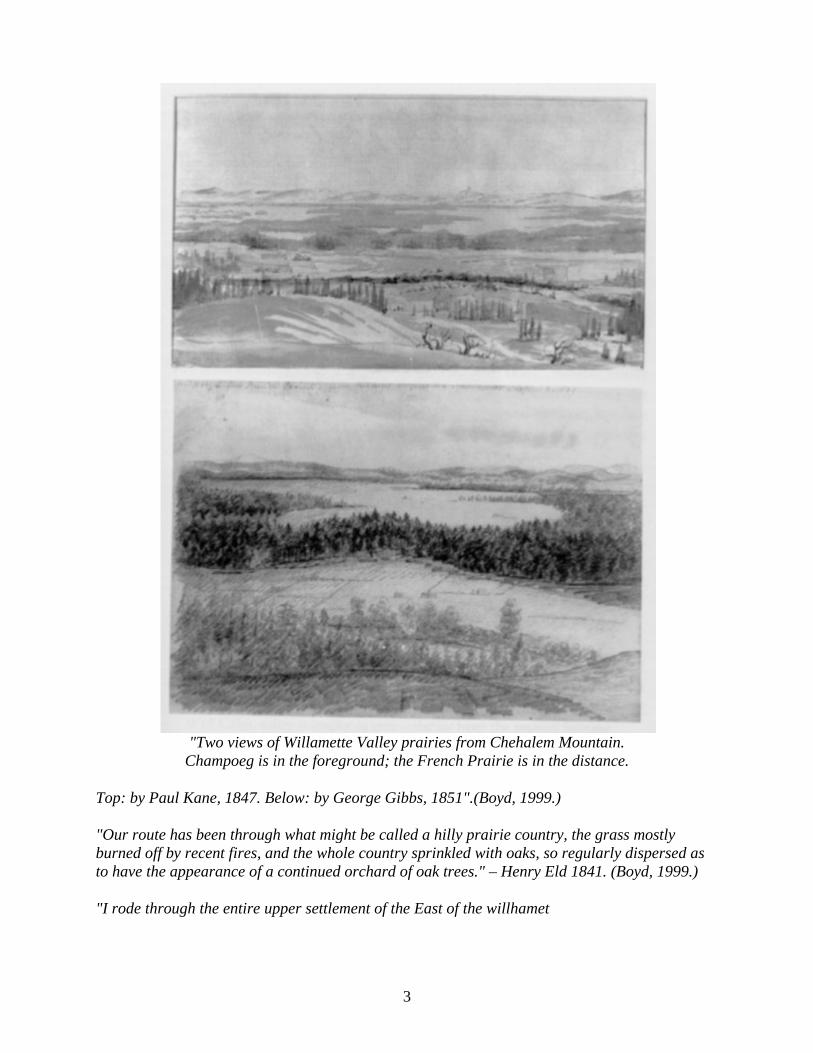
"Two views of Willamette Valley prairies from Chehalem Mountain.
Champoeg is in the foreground; the French Prairie is in the distance.
Top: by Paul Kane, 1847. Below: by George Gibbs, 1851".(Boyd, 1999.)
"Our route has been through what might be called a hilly prairie country, the grass mostly burned off by recent fires, and the whole country sprinkled with oaks, so regularly dispersed as to have the appearance of a continued orchard of oak trees." – Henry Eld 1841. (Boyd, 1999.)
"I rode through the entire upper settlement of the East of the willhamet
4
[Waldo Hills] and was highly pleased with the beautiful veriaty of hill and vally so softly varied and intermingled with hill and dale as Likewis timber and Prairie all luxuriently clothed in a rich and heavy coat of vegetation and litterly clothed in Flowers the uplands in yallow and the vallys in purple. The Quantity of small flowering vegittiles is verry remarkable and beyond all conception." James Clyman 1846 (Boyd, 1999.)
Natural Heritage Parks Plan
Executive Summary
I. Introduction
II. Current Park Status & County Conditions A. Current status of Marion County Parks - Level of Service B. What is the context? 1. Historical conditions 2. Current County environmental conditions C. What is the problem within that context? 1. Loss of the plants and animals & their ecosystems 2. Loss of environmental functions 3. Loss of historical landscapes
III. Addressing the Problem A. Benefits B. Acquisition & Restoration goals
IV. Methods for Site Identification and Evaluation
IV. Methods for Site Identification and Evaluation A. Development of a decision framework 1. Determining ecological communities to be restored 2. Selection criteria B. Restoration considerations C. GIS analysis
V. Results: Identification of sites with acquisition potential
VI. Site Acquisition B Partnerships, Funding, and Processes
VII. Further Considerations A. Community involvement B. Program evaluation C. Decision model limitations
VIII. Conclusions

5
Bibliography
Appendices
Appendix A. List of Marion County’s threatened & endangered plants & animals Appendix B. Relevant Comprehensive Plan language Appendix C. Detailed criteria descriptions and GIS analysis Criteria description table Appendix D. Initial field assessment data sheet Appendix E. Restoration guidelines

6
Marion County Natural Heritage Parks Plan
Executive Summary
This appendix to the 2010 Parks Master Plan supersedes the original Natural Heritage Parks Program, adopted by Resolution 01-10R of the Marion County Board of Commissioners on February 21, 2001.
Recognizing the recreation needs of a growing population and a decline in the level of service that Marion County’s parks are currently providing, the Parks program should ideally expand its current system of parklands. Due to current budgetary limitations, however, the parks that can be provided by Marion County in the short-term may tend toward the less developed, nature-type parks with limited facilities, such as picnic tables and soft paths. The Natural Heritage Parks Plan provides a way of locating and rating different areas for their potential as future parkland. It also describes ways to derive additional benefits from the new park sites through ecological restoration and preservation processes. By doubling as restoration sites, these new parklands will help address the loss of historical ecosystems and provide increased recreational opportunities to county residents.
With its increased development and growing population, Marion County has lost many of the ecosystems that existed prior to Euro-American settlement. Those pre-settlement ecosystems included forested uplands, prairies, oak savannas, wetlands, shrub-lands, and riparian forests. Within these ecosystems there were unique communities of plants and animals, many of which have become rare or are absent in today’s Marion County. Historically, the ecosystems also provided important environmental benefits, such as flood control, groundwater recharge, and soil stabilization. In a modern context, these ecosystems also serve as important aesthetic and recreation resources. The loss of these ecosystems threatens not only the environmental quality of Marion County, but also its connection to a rich natural history.
In an effort to re-create some of this lost natural heritage and provide high-quality outdoor recreation, it is the goal of Marion County to have each of its pre-Euro-American settlement ecosystems restored and represented in at least one "Natural Heritage Park." The Natural Heritage Parks Program has three primary objectives.
1. Provide visitors the opportunity for nature-oriented recreation, environmental education, and appreciation of Marion County’s natural heritage.
2. Provide critical habitats for rare plants and animals.
3. Reestablish important environmental processes.
To select the potential Natural Heritage Park sites, the pre-Euro-American settlement ecosystems that the county wished to represent within the park system were first defined. Working with these historical ecosystems as objectives, a decision framework was developed for identifying specific areas that could be preserved or restored, while also providing secondary benefits that achieved county goals. This framework was developed through research of similar projects,

7
recommendations from county staff members, discussions with other public land management agencies, and a close examination of the county’s long-term goals.
The decision criteria resulting from this research fell into five primary categories: 1) preservation opportunities, 2) hydrologic features, 3) soil stability, 4) land use/location, and 5) ownership. Within these five categories specific site selection criteria were developed as mapped data. These criteria included the rarity of a given ecosystem, proximity to other public lands and schools, ease of public access, convergence of multiple ecosystems, proximity to sensitive habitats, and the sites’ current physical conditions, among many other items. Using these criteria, six primary areas with restoration potential were identified. (See Map: "Rankings of Potential Parkland" - Numbers correspond to this map.)
Number Name of Area Restoration Ecosystem
Acquisition Priority
14 Stout Mountain Savanna, prairie, woodland, wetland High priority 7, 8, 9 Aumsville/Mill Crk. Area Shrubland, wet prairie, riparian High priority
6 Salem Hills West Savanna and upland prairie Medium priority10 Turner to Marion Area Wet prairie and savanna Medium priority11 Santiam Delta Riparian forests and prairie Medium priority15 Eola Point Riparian forests and wetland Medium priority
By taking a systematic approach to the acquisition of sites within these and similar areas, Marion County can, over time, improve the park system’s level of service while providing relatively low-cost, high-value parkland that restores and conserves important ecosystems before they are further disturbed or lost entirely. The conservation of these ecosystems within the park system will also serve as a structure for the enhancement of their environmental processes, and consequently improve the environmental quality of the county. With thoughtful restoration and diligent maintenance, these sites have the potential to promote and preserve Marion County’s natural heritage while also serving as important refuges for threatened species and unique recreation destinations for county residents.

8
I. Introduction
Recognizing the recreation needs of a growing population and a decline in the level of service that Marion County’s parks are currently providing, the Natural Heritage Parks (NHP) Plan proposes to expand its current system of parklands. Due to current budgetary limitations, the parks that can be provided by Marion County may tend toward the less developed, nature-type parks with limited facilities, such as picnic tables and soft paths. The NHP Plan provides a way of locating and rating different areas for their potential as parkland. The Plan also describes ways to derive additional benefits from the new park sites through ecological restoration and preservation processes.
II. Current Park Status and County Conditions
Current Status of Marion County Parks - Level of Service and Funding
The Marion County Parks system currently contains 746 acres of developed and undeveloped parkland. Of that total, 477 acres are developed parks and 269 acres are undeveloped parks. Further discussion of the level of service provided by Marion County Parks is contained in the 2010 Parks Master Plan.
Considering the budgetary limitations of the Parks program, one way to provide an increased level of service is through low-cost, nature-oriented parks. While the costs of restoring parkland to its pre-settlement conditions can still be considerable, they are small when compared with that of developing and maintaining an intensive-use park with facilities like ball fields and shelters.
Today’s high costs for developed parks require a focus on less costly, nature-type parks for near future park expansion. In order to direct the acquisition of additional lands, while minimizing the costs and capitalizing on their potential secondary environmental benefits, it is important to understand the landscape in which these areas are situated.
Historical conditions (See Map: Pre-European Settlement Vegetation - Probable Natural Vegetation)

9
Drawing from information found in early land surveying records and settler accounts, we can recreate a picture of the landscapes that greeted this area’s first pioneers. The pre-settlement landscape that they saw was not untouched by humans. Native Americans had managed the valley by using deliberately-set fires as a way to maintain game habitats, desirable plants, and open areas. Some of the early landscapes such as the scenic oak savannas and native grass prairies that covered much of Willamette Valley were a direct result of this fire ecology (Boyd, 1999.) Along the rivers spread forests of cottonwood, alder, ash, and other hardwoods, sometimes for miles back from the banks. Extensive wetlands formed along the winding rivers and also made up shrub swamps, wet prairies, and marshes. (Oregon Biodiversity Project, 1998. Hulse, 1998.)
Current Conditions (See Maps: Current Vegetation & Pre-European Vegetation - Existing Contemporary Occurrences)
With increasing settlement of the area came deliberate fire suppression, intensive agricultural and forestry practices, and the influx of new plants. The landscape quickly changed from its pre-settlement conditions to the ones we would more readily recognize today. Areas that once held ecosystems such as the oak savannas, wide riverside forests, expansive wetlands, and open prairies, now feature growing urban centers, highly productive agricultural and forested areas, and rural homes. (Hulse, 1998.)
Currently agriculture, production-oriented forests, and urban development occupy the largest areas of the county. As the maps indicate, the ecosystems that once defined the Willamette Valley have been reduced to small, scattered pockets, or lost entirely. As can be seen from Table 1, nearly 90% of the Valley’s pre-settlement ecosystems have been converted from their original condition. (Hulse, 1998.) While some plants and animals can adapt to this new environment, the ones that cannot are restricted to the remaining fragments of undisturbed lands.

10
Table 1. Comparison of pre-Euro-American settlement and contemporary ecosystems across entire Willamette Valley. (Hulse 1998.)
Willamette Valley Vegetation Type Year 1850 (acres) Year 1995 (acres) Amount Lost
Riparian/Bottomland Forest 350,999 98,924 72%
Bottomland/Wet Prairie/Shrubland 877,240 4,942 99%
Emergent Wetland 4,695 1,992 58%
Douglas Fir Upland Woodland 362,132 47,564 87%
Oak savanna and prairie 1,701,536 206,269 88%
Total acres 3,296,602 359,691 89% Anticipated future conditions (See Map: "Year 2050 Land Use/Land Cover")
A study conducted by the University of Oregon provides some insight into future land use patterns. Operating under the assumption that current development trends are expected to continue into the near future, the "Anticipated 2050 Land Use" map indicates the population of the Willamette Valley is expected to double, with a corresponding increase in urban density and area. The growing population will place increasing demand on available land resources, reducing options for future park acquisition and inflating the costs of those acquisitions. This larger population will also require additional parkland to meet its recreational needs.
Implications of these conditions
The implications of these changes in Marion County’s landscape include the additional loss of unique ecosystems as well as the loss of the plant and animal species that depended on them.(Oregon Biodiversity Project, 1998.) In addition to this decrease in biodiversity, losing these ecosystems also reduces important environmental functions such as flood control,

11
groundwater recharge, soil stabilization, and water quality. (U.S.A.C.E, 1999. Cairns, 1994.) While these losses are substantial, there are also historical and recreation implications to consider. Without the presence of these recreation areas, people have few opportunities to interact with the county’s natural history or understand the landscapes that greeted early pioneers and sustained Native American tribes. And without an understanding of how these landscapes formed and functioned, Marion County citizens may not be able to adequately address current natural resources issues.
Ecological Restoration Parks can provide many of the same recreational benefits as more developed parks, while providing an increased level of environmental benefit. Here, bikers and dog owners enjoy Minto Brown Island Park - a restored site in Salem, Oregon.
III. Addressing the problem
To accomplish its goal of increasing the level of service provided by the County Parks, the County developed a plan to acquire properties and restore them to pre-settlement conditions through the "Natural Heritage Parks" program. In addition to land acquisition and restoration, the Natural Heritage Parks program also provides for the development of education, recreation, and secondary environmental benefits within the park system.
Already, the Natural Heritage Parks program has guided the negotiation and planning of park properties. Aumsville Wetlands (77 acres), Wiseman Island (170 acres), and Eola Point (287 acres, transfers to county within 30 years) are all properties that either have been or may be incorporated into the Natural Heritage Parks program.

12
The primary objective of this program is to have each of the pre-settlement ecosystems represented within the park system. These ecosystems would include specific ecological communities that fall under the general categories of oak savannas, prairies, riparian forests, wetlands, shrublands, and upland forests. The lands acquired for use in Natural Heritage Parks must be suitable for restoration, compatible with broader county goals of education and recreation, and coordinated with similar efforts within the county.
By taking an active and immediate role in the preservation and restoration of historical ecosystems, Marion County can begin to address some of the problems that have resulted from the loss of these ecosystems - while providing high-value recreation benefits to county residents. Restoration will enhance the county’s biodiversity by the propagation of rare plants and the re-creation of ecological communities. Acquisition of critical properties will help to ensure continued preservation of rare plants and animals. The restoration efforts will also aid in re-establishing lost environmental functions, thereby enhancing the area’s environmental quality. Additionally, restored areas will help correct the loss of the history that was represented in pre-settlement landscapes. By understanding the historical ecosystems at these sites, area residents will have a broader base of knowledge to draw from in addressing current and future natural resource issues.
The restoration and conservation of land, when conducted within a sound management system, has proven to be an effective means of arresting, and even reversing, the loss of rare plants and animals. (Maybury, 1999) By reestablishing the vegetation of an area and removing detrimental human disturbances, the ecological processes that occurred historically on the site can also be restored. These processes can provide a foundation for sustainable populations of threatened species and can also contribute to an area’s environmental quality. (Berger, 1990.)
By focusing on restoration of known physical and biological elements within ecological communities, the county provides an environment in which many other processes can occur and organisms can thrive without direct action. The restored communities provide the structure for these processes. The Nature Conservancy describes this as the "coarse filter" system. That organization uses it as a highly effective means of preserving little known processes and species through the conservation of recognizable ecosystems. (Maybury, 1999) In other words, when Marion County restores and protects an ecological community, there will be benefits far beyond the representation of a few targeted species.
In addition to their educational, recreational and ecological benefits, these restoration sites are selected to provide a number of secondary benefits. Properly planned, the secondary benefits could include flood abatement, erosion reduction, stormwater retention, increased groundwater recharge, landslide prevention, and nutrient uptake. These valuable functions are more easily accomplished through nature oriented parks rather than developed parks.
IV. Methods for Site Identification and Evaluation
A. Development of a decision framework
Implementation of the Natural Heritage Parks program first required the development of a deliberate decision framework in which the County’s goals can be considered and in which park department’s objectives can be clearly identified and acted upon. Also through this process sites

13
can be systematically identified, assessed, acquired, restored, and monitored. This report outlines the method of site selection, discusses the incorporation of County goals, and provides a list of sites with acquisition potential1.
The decision framework developed in this report draws from a number of sources. The County goals and policies are drawn from the Marion County Comprehensive Plan, the Marion County Parks Master Plan, and natural resource management priorities (i.e. stormwater retention, flood control). The site identification section was developed through discussions with stakeholders, natural resource management professionals, and through research of similar projects.
The overall decision framework (see Fig. below) follows the flow of information from the County goals through the definition of objective, the development of criteria, site identification & assessment, acquisition, restoration, and monitoring. Project evaluation, community input, and professional input are central to the process and will influence each step. During this process, citizens and professionals - through advisory groups, classes, and volunteer groups - provide input toward setting goals, identifying sites, restoring sites, and monitoring the restoration.
By working within the decision framework developed in this report, Marion County can systematically address key issues facing the Natural Heritage Parks program. This framework, however, also allows flexibility in the sequence of restoration and acquisition.
A. 1. Determining ecological communities to be restored
Before specific park site candidates can be determined, the County first clarified its restoration targets. This process begins with an examination of the pre-Euro-American settlement ecosystems that existed in Marion County. These ecosystems included the general categories of:
1. Upland prairies - xeric* grasslands with little or no woody vegetation, burned frequently.
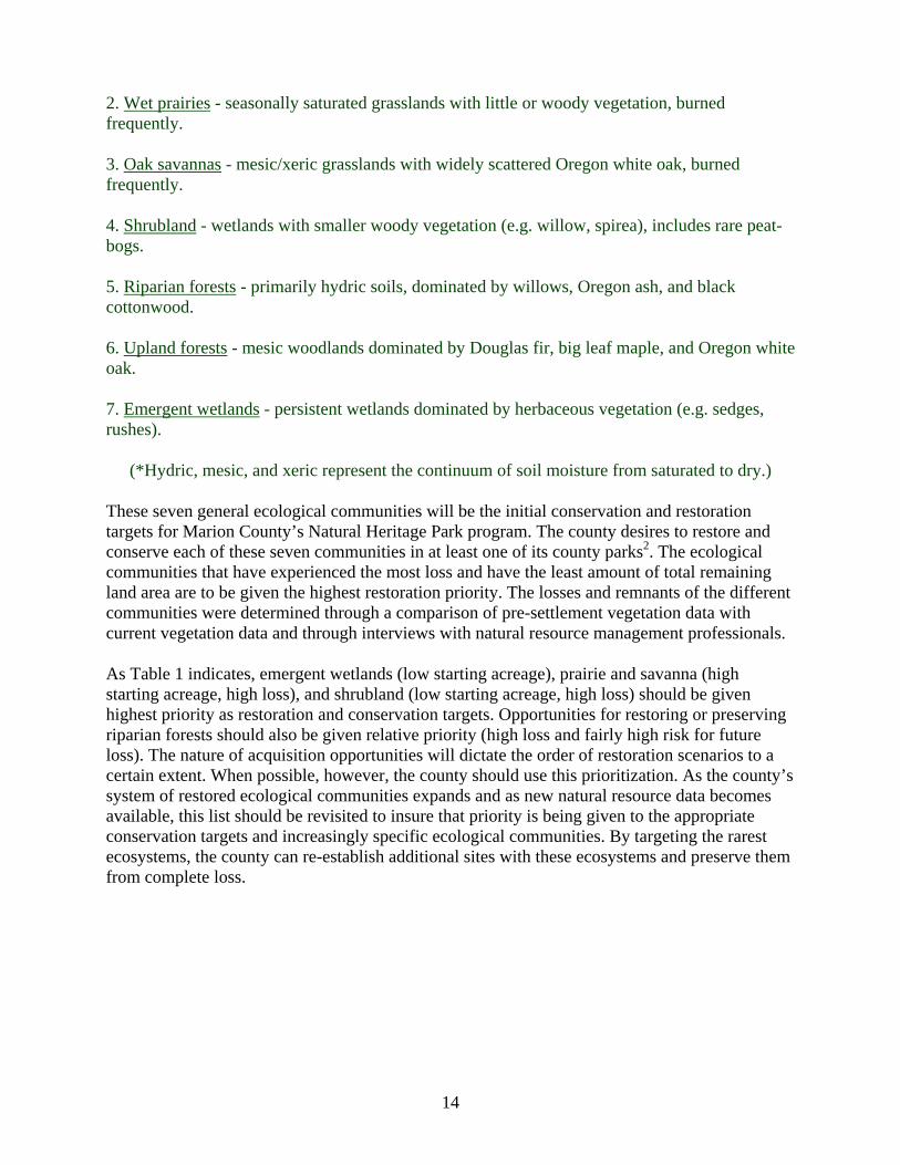
14
2. Wet prairies - seasonally saturated grasslands with little or woody vegetation, burned frequently.
3. Oak savannas - mesic/xeric grasslands with widely scattered Oregon white oak, burned frequently.
4. Shrubland - wetlands with smaller woody vegetation (e.g. willow, spirea), includes rare peat-bogs.
5. Riparian forests - primarily hydric soils, dominated by willows, Oregon ash, and black cottonwood.
6. Upland forests - mesic woodlands dominated by Douglas fir, big leaf maple, and Oregon white oak.
7. Emergent wetlands - persistent wetlands dominated by herbaceous vegetation (e.g. sedges, rushes).
(*Hydric, mesic, and xeric represent the continuum of soil moisture from saturated to dry.)
These seven general ecological communities will be the initial conservation and restoration targets for Marion County’s Natural Heritage Park program. The county desires to restore and conserve each of these seven communities in at least one of its county parks2. The ecological communities that have experienced the most loss and have the least amount of total remaining land area are to be given the highest restoration priority. The losses and remnants of the different communities were determined through a comparison of pre-settlement vegetation data with current vegetation data and through interviews with natural resource management professionals.
As Table 1 indicates, emergent wetlands (low starting acreage), prairie and savanna (high starting acreage, high loss), and shrubland (low starting acreage, high loss) should be given highest priority as restoration and conservation targets. Opportunities for restoring or preserving riparian forests should also be given relative priority (high loss and fairly high risk for future loss). The nature of acquisition opportunities will dictate the order of restoration scenarios to a certain extent. When possible, however, the county should use this prioritization. As the county’s system of restored ecological communities expands and as new natural resource data becomes available, this list should be revisited to insure that priority is being given to the appropriate conservation targets and increasingly specific ecological communities. By targeting the rarest ecosystems, the county can re-establish additional sites with these ecosystems and preserve them from complete loss.

15
Table 2. Pre-Euro-American settlement ecological communities in Marion County’s valley region (Natural Heritage Program database, 2000) and their acquisition priority.
Type of eco. community
Priority Description of Vegetation
Closed forest; Riparian Med. Ash swamp and ash swale, sometimes with alder.
Closed forest; Riparian Med. Ash-alder-willow swamp, sometimes with bigleaf maple. Often with vine maple, ninebark, hardhack, cattails. Ground very soft miry, or muddy.
Closed forest; Riparian Med. Ash-willow swamp, sometimes w/ ninebark & briars.
Closed forest; Riparian Med. Ash-mixed deciduous riparian forest with combinations of alder, bigleaf maple, black cottonwood, white oak. Conifers may be present in small quantities.
Closed forest; Riparian Med. Red alder-mixed conifer riparian forest; combinations of cedar, grand & Douglas fir, hemlock, bigleaf maple, black cottonwood. No oaks. Large conifer component, though.
Closed forest; Riparian Med Red alder-mixed conifer riparian forest; combinations of cedar, grand & Douglas fir, hemlock, bigleaf maple, black cottonwood, but burned, often with scattered trees surviving.
Closed forest; Riparian Med. White oak-ash riparian forest, sometimes with cottonwood and willow.
Closed forest; Riparian Med. Black cottonwood forest, sometimes with willow, rose, briars, nettles, crabapple, sometimes ash. No Conifers.
Closed forest; Upland Low Douglas fir forest, often with bigleaf maple, dogwood, hazel, yew. No other conifers present. No oaks.
Closed forest; Upland Low Douglas fir forest, often with bigleaf maple, dogwood, hazel, yew. No other conifers present. No oaks. But burned, often with scattered trees surviving.
Closed forest; Upland Low Mesic mixed conifer forest with mostly deciduous understory. May include Douglas fir, western hemlock, red cedar, bigleaf maple, yew, dogwood, white oak, red alder.
Closed forest; Upland Low Mesic mixed conifer forest with mostly deciduous understory, but burned, often with scattered trees surviving. May include Douglas fir, western hemlock, red cedar, bigleaf maple.
Closed forest; Upland Low Douglas fir-white oak (bigleaf maple) forest, with brushy understory of hazel, young oak, oak bracken, briars, sometimes willow.
Closed forest; Upland Low White oak forest, oak brush, or oak and hazel.
Closed forest; Upland Low White oak-Douglas fir-ponderosa pine forest.
Emergent wetlands High Marsh, composition unknown; includes "wet meadows."
Emergent wetlands High Pond lily aquatic bed, sometimes with skunk cabbage.
Emergent wetlands High Swamp, composition unknown.
Emergent wetlands High Wetland, composition unknown; includes "slough forest" or shrubland; swale in prairie.
Herbaceous Upland Med Fern openings, fern hills, or open fern land. May contain hazel. No trees.
Prairie High Upland prairie, xeric. May have scattering trees.
Prairie High Vernal pool
Prairie High Seasonally wet prairie May have scattering trees.
Savanna High Douglas fir savanna.

16
Savanna High Douglas fir-ponderosa pine savanna.
Savanna High White oak savanna.
Savanna High White oak-ash savanna.
Savanna High White oak-Douglas fir savanna, mostly herbaceous understory.
Savanna High White oak-Douglas fir-ponderosa pine savanna
Shrubland High Shrub swamp ("brush swamp", "marshy thicket", thicket"), composition unknown.
Shrubland High Brush, unknown; includes "thickets".
Unvegetated NA Gravel bar
Unvegetated NA Sand bar and sandy barrens
Water NA Water bodies 1 or more chains across, including ponds, beaver ponds, lakes, marshy lakes and "bayou."
Woodland Med "Scattering" or "thinly timbered" Douglas fir-pine woodland, with brushy undergrowth of hazel. May include small openings.
Woodland Med Scattering or thinly timbered Douglas fir-white oak. May contain bigleaf maple; brushy understory of oak brush, young fir, bracken. No pine.
Woodland Med Douglas fir woodland or "timber" often with bigleaf maple or dogwood. No oak, hemlock or cedar. Brushy understory of hazel, vine maple, young Douglas fir, bracken fern.
Woodland Med "Scattering" or "thinly timbered" white oak woodlands. With understory of hazel, oak, bracken. No fir or pine.
A.2. Selection Criteria
The identification of areas as potential parkland required the development of explicit decision criteria that stemmed from two basic questions, "What would be the components of an ideal park site? How can those components be expressed through a set of decision criteria?" Those criteria were developed with the assumption that future park sites should serve as more than just recreation locations. They should also address other county needs such as education, environmental quality, and land use plan implementation.
The determination of these site selection criteria was accomplished through interviews with county and local officials, state and federal land management agencies, and other organizations involved with restoration efforts. The specific criteria included such considerations as soil type, level of disturbance, presence of rare plants and animals, proximity to other public lands, and proximity to sensitive hydrologic features, among many other items. It is important to note that the data do not always lend themselves to strict categories, so there are some necessary overlaps in the criteria. For example, the level of disturbance to a site is also often reflected in other criteria such as the presence of rare plants and current land use. Rather than weakening the decision model, however, the overlaps ensure that complex factors are considered from a number of different angles.
The selection model (See Fig. below) in which the criteria are organized allows multiple objectives (expressed through the five categories) to be considered in site selection. By

17
organizing the criteria in this manner, a number of objectives can be achieved through acquisition and restoration of the same site. The deliberate consideration of these many factors will help the county avoid a "hit and miss" approach to parkland acquisition. While many sites may initially seem like good acquisition candidates, only careful consideration of the many criteria will insure a given site is appropriate to use as a restoration site3.
There are five categories of site selection criteria:
1. Preservation areas
(Sensitive features)
The criteria in this category favor sites that contain valuable ecological communities or rare species that could not accommodate development or land uses other than preservation/restoration. This category includes data such as: endangered species; salmonid distribution; natural, scenic, and archeological sites identified in the Comprehensive Plan; and areas with a history of limited human disturbance.

18
The amount of change in the soil, vegetation, and hydrology will have a direct effect on the cost and potential effectiveness of restoration, so lands that have had the fewest changes from their pre-settlement conditions would be better candidates for restoration and given highest priority. These levels of disturbance are derived from current land use maps and vegetation maps. Lands that have been extensively developed or used for extractive purposes may be less viable candidates than those that were relatively undisturbed or indicated only low intensity past uses.
Areas already containing threatened or endangered populations of plants and animals would be given highest priority. This would allow the preservation of the present species and would also reduce the costs of restoration, since it would not require the reintroduction of these species. The presence of rare native plants of sufficient number to provide seeds would also encourage the selection of a given site. These plants are important not only for conservation, but also as a potential seed bank for local restoration projects. Often, seeds of these plants are either unavailable commercially, or the commercial varieties come from distant areas. In order to preserve the genetic diversity of the rare plants, local seed sources are important. Acquiring lands for this purpose will also be a consideration.
Sometimes, more than one ecosystem occurs on the same site, in which case the site would be given a preference in selection. By restoring and preserving multiple ecosystems on a given site, the county can reduce its acquisition costs and capture the site’s biodiversity.
The County would also place a high priority on the rarest ecosystems that are facing conversion beyond restoration potential. The data used to determine the level of threat to a particular site will be drawn from studies that project future land use trends. Ecologically valuable sites that these futures studies indicated were likely to be developed would be given higher acquisition priority.
2. Hydrology
These criteria favor sites that protect or enhance hydrologic quality and function. The category includes data such as: surface water features, contaminated streams, 100 year flood plain, and hydric soils. When possible, park sites would be located and restored in a manner that provides secondary benefits beyond the ecological preserves. For example, sites with wetlands could be used for flood control, and sites located in important groundwater recharge areas could be used to increase groundwater availability. The potential of a given site to provide these benefits would increase its likelihood of selection.
3. Soil Stability
The sites identified by this layer are valuable because they are susceptible to erosion and landslides. A park occupying these sites would provide a permanent vegetation cover, reducing erosion risk. Siting a park in these areas would also provide protection against development on areas with high erosion and landslide potential. The erosion layer was derived from a slope/soil-type model. The landslide layer was developed from recent Salem/Marion County landslide potential studies.

19
4. Land Use/Location
The areas identified by these data are located near preferred land uses such as schools, county roads, and Urban Growth Boundaries. Other data in this category were used to exclude highly productive agricultural land and industrial zoned areas. The proximity of a given site to population areas and user groups would increase its likelihood of selection. Where possible, the parks would be located within a reasonable distance of population centers and schools. This would increase the educational and recreational use of the parks.
5. Ownership
Areas adjacent to land currently in public ownership - particularly county ownership - are favored in the model. By grouping or strategically placing publicly owned lands and by coordinating management goals, the county could provide a larger restoration area as well as broaden opportunities for education and recreation. This proximity also allows for connectivity between ecosystems B an important ecological consideration. However, this connectivity and clustering will have to be balanced with the need to distribute the parks around the county so that most of the residents have easy access to at least one restoration park.
The size of a site influences its restoration opportunities and locating a park next to existing public land may increase those opportunities. Some ecosystem restoration efforts, such as those that restore ecosystems that formerly covered large expanses of land, might require larger parcels to better represent the historical ecosystems. Larger sites typically contain a greater diversity of plants, animals, and land features. They also are more likely to contain functioning ecosystems and have less edge per acre B lessening external influences and minimizing losses through disturbance. Larger sites can also encompass multiple ecosystems, thus reducing the need for additional acquisition (Poiani and Richter, 1999.)
County goals & projects as selection criteria
In addition to the mappable data, the site selection process must also consider factors, such as county planning guidelines, that do not directly lend themselves to mapping.
Comprehensive Plan
In keeping with Marion County’s Comprehensive Plan4 and Oregon’s Statewide Planning Goals & Guidelines, the criteria will reduce consideration of lands less suited for parkland and focus on the acquisition of lands that can meet the specific goals laid out in the ordinances. The 1995 Statewide Planning Goals state that the county will "insure open space, protect scenic and historic areas and natural resources for future generations, and promote healthy and visually attractive environments in harmony with the natural landscape character." Like the state’s planning guidelines, The Parks and Recreation Goals of Marion County, as identified in the Comprehensive Plan, call for preservation of unique natural areas, maintenance of a relationship with the past, and incorporation of environmental protection into park acquisitions (Comprehensive Plan, Parks and Recreation). The Natural Heritage Parks program addresses each of these goals. It provides preserved open space with historical significance and aesthetic harmony, and it restores a healthy environment. Sites identified in this study should be considered for inclusion in future revisions of the Comprehensive Plan.
20
The Environmental Quality and Natural Resources Goals of Marion County are identified as maintaining optimal ecological balances, minimizing soil erosion, and improving water quality. As previously stated, the restoration and careful location of the Natural Heritage Parks would provide not only the ecological benefits of rare plant protection and ecosystem restoration, but also provide secondary benefits that may include erosion control, improved groundwater recharge, landslide abatement, and flood control. Sites that provide these secondary environmental benefits would be given preferential selection.
Marion County Parks Master Plan
The 2010 Marion County Parks Master Plan, to which the Natural Heritage Parks Plan is an Appendix, details the County’s existing conditions and needs for additional parkland.
Other county projects
The restoration efforts are to be continually examined within the context of current and future county projects. The types of projects that could be coordinated include retention basin construction, floodplain protection, wetland banking, and water quality enhancement efforts. The coordination of these projects with park restoration and acquisition will reduce incompatible development while also providing the opportunity to build on projects already underway or build on land already within county ownership. Integration of Best Management Plans (BMP) with the goals of the Natural Heritage Park program is one possible avenue to help further the aims of both efforts. The BMPs could be used, for example, to expand native plant restorations along roads and to provide connectivity between the Natural Heritage Parks and other ecological restoration areas.
Other restoration projects
The county will attempt to locate the Natural Heritage Parks near other restoration efforts around the county and also coordinate the park management with the broader goals of other restoration efforts. This coordination will help ensure the parks are not "stand alone" parks, but that they fit within a broader context of environmental preservation and enhancement. Adjacent sites could also provide enhanced recreation opportunities such as connected trails or common interpretive themes. Sites that would accomplish these goals through their proximity to long-term conservation easements and permanent restoration sites are more likely to be selected. Some programs that could provide a broader context and direction for Marion County’s restoration efforts include the Willamette Restoration Initiative, the Oregon Plan for Salmon and Watersheds, the Willamette Greenways program, the American Heritage Rivers program, the Nature Conservancy’s conservation programs, and programs within the Salmon Recovery Plan.
Restoration considerations
The process of restoration is an integral part in the site selection process. Restoration must be conducted in a systematic and thorough fashion to avoid devoting limited resources to short-term or incomplete projects. The limitations, both physical and fiscal, that are imposed by restoration at a specific site will influence the selection of that site. Sites that require extensive restoration may require excessive funding or time and may be a lower priority for acquisition.
21
The following are general restoration principles adapted from SER’s guidelines and integrated into the site selection criteria5.
1. Develop a restoration plan that includes baseline ecological assessments, specific goals, measurable standards, and provisions for the resources necessary to restore and maintain a site.
2. Closely monitor and control non-native plants and animals.
3. Integrate the restoration project with broader-scale goals.
4. Use locally procured, native plants whenever possible.
5. Take into account the interaction of adjacent ecosystems, such as uplands near wetlands or forests near a river.
6. Actively seek the involvement and input of the local community.
By choosing sites that allow close adherence to the Society for Ecological Restoration (SER) restoration guidelines, the county can limit the amount of time and money devoted to a given project and help insure its sustainability.
GIS analysis and evaluation The development of specific site selection criteria allowed the integration of existing geographic data into a decision model. This process was conducted through the use of a geographic information system (GIS). As the Fig. below indicates, the selection criteria6 were integrated into the GIS analysis by determining which existing data layers could best express the criteria’s intent. For example, the criteria "Preservation areas" was expressed by using data such as natural vegetation, scenic areas, and archeological sites. The criteria "Land Use/Location" was partially expressed by data showing the location of population centers and the network of county roads. Once the data layers that expressed these criteria had been assembled, their values were

22
determined.
The data values within each layer were then used to rank every location within the county as to its fulfillment of selection criteria. For example, the site selection criteria of "endangered species" indicates that areas containing endangered species are preferable to those that do not. Within the endangered species data layer, every site in the county could be ranked according to its immediate proximity to an endangered species location. Sites within 0-250' would get a ranking of 9 and sites within 250-500' would get a ranking of 5. This increases the value of those areas closest to the desired feature.
This same technique was then used for each site selection criteria. When they were combined, the values assigned to each data layer (weights) indicated the importance of that criteria relative to others. More important data layers, such as the presence of endangered species and the level of disturbance were given a higher weight. Less important data layers, such as the proximity to county roads, were given a lower weight. Data layers of the county’s hydric soils, proximity of sites to existing parks, and existing vegetation, for example, could be ranked and then combined to generate a final map identifying a specific site that shows little disturbance to original vegetation, that is located near an existing park, and that has the correct soil type for the desired ecosystem. In other words, this site would be identified as one with high restoration potential because it has highly valued elements from all three maps. This process was done for each of the selection criteria and the areas that were identified as high potential restoration sites for each pre-settlement ecosystem were identified through this process. (See Map: "Modeling Criteria Values")

23
These sites were then verified using air photos, and the best candidates appear numbered on the "Rankings of Potential Parkland" map. In this version of the Selection/Acquisition Plan, the sites were only verified against air photos and tax lot data. As part of the next step, an on-site survey will focus on the highest value areas, providing an assessment of physical characteristics such as the presence of noxious weeds, existing plant associations, site hydrology, wildlife, evidence of disturbance, and surrounding land use7. This analysis will narrow the field of candidates considerably, and allow the county to focus on ones with the greatest potential as parkland. Other opportunities not identified specifically within this process, however, can still be accommodated within the broader decision process.
V. Results: Identification of sites with restoration potential
(See Map: "Rankings of Potential Parkland")
The maps resulting from the use of park selection criteria show areas that should be examined for potential acquisition and restoration. Each specific acquisition candidate, however, will require
24
individual consideration. Unique ecological and economic factors, such as those described previously, will influence each acquisition. Due to gaps in the data layers and the scale of the data, some sites outside of these designated areas may also be good candidates for selection. Once identified, however, these other sites should still be evaluated using the same criteria.
Site selection summary
Top acquisition candidates:
Oak savanna restoration
Salem Hills West
Salem Hills West (Bunker Hill Area) Large, contiguous oak uplands with some Douglas fir. Sites with lower density oaks would be good candidates for savanna restoration. Some larger private holdings exist, but the area is mostly medium to small private holdings. This area was also identified in previous county restoration studies. Its location near population centers enhances its value for park purposes. Previous studies also indicated Stout Mountain as a potential candidate for savanna restoration. Salem Hills East Similar to Salem Hills West, but smaller in area. Some larger, private land holdings may be candidates for restoration.
Upland prairie restoration
Salem Hills West
Salem Hills West Large, contiguous area; mostly wooded with oaks and fir, but unmanaged pasture lands within this area could provide good restoration sites. Possibly a site with both oak savanna and upland prairie restoration potential could be found. The Bunker Hill area (within Salem Hills West) was previously identified within county restoration studies. Areas in Salem Hills East also indicate some good candidates for prairie restoration. The southern edge of Salem Hills East should be examined for wet prairie restoration candidates.
Oak / Douglas fir woodland restoration
Stout Mountain
Stout Mountain - Large, private ownership with diverse ecosystems. Previously identified within the Comprehensive Plan and other county documents as an excellent restoration candidate. Studies indicated little development or disturbance on this property. Previous studies indicate that there may also be potential on the site for prairie and savanna restoration. The Salem Hills (East and West) also offer good oak /Douglas fir woodland restoration candidates.

25
Wet Prairie restoration
Perhaps the most problematic of the restoration scenarios. Little or no wet prairie remains in the county - in areas of any size. The area to the southwest of Aumsville and southeast of Turner seems to have the largest concentration of unmanaged pasture in locations where wet prairies formerly existed. This area may contain candidates for wet prairie restoration. The mitigation banks that are under development (Marion and Grenz Mitigation Banks) in that area may also be good candidates for wet prairie restoration.
Areas identified through decision model
(See Map: "Ranking of Potential Parkland" )
Name: Champoeg Creek Corridor
Location: South of Champoeg Creek State Park
Model Ranking: Medium high - high emergent wetland, medium riparian, medium woodland.
Current vegetation types: Unmanaged pasture, ash/cottonwood, maple bottom, willow
Pre-settlement vegetation: Willow swamp; riparian (red-alder mixed conifer); and Douglas fir white oak woodland.
Local hydrologic features: Champoeg Creek, Willamette River, Case Creek
Local infrastructure: Champoeg Creek State Park, St. Paul (~ 5 miles), French Prairie Road, St Paul Highway
Ownership: Private and public (park)

26
Surrounding land use: Agriculture
Notes: Acquisition here could provide connectivity with Champoeg State Park. Riparian corridor with diverse ecosystem restoration scenarios possible - wetlands, riparian, and possible oak/fir woodlands. Numerous ownerships and linear resource may make for difficult acquisition.
Name: Pudding River Corridor
Location: Length of Little Pudding River (from State St. to Butte Creek Confluence)
Model ranking: Medium-high riparian, medium prairie, some high riparian
Current vegetation: Black hawthorn riparian, cottonwood riparian, and some pasture land
Pre-settlement vegetation: Ash willow swamp, sometimes with ninebark and briars; Douglas fir forest, often with big-leaf maple, grand fir, dogwood, hazel; Willow swamp with ninebark. Also, Red alder - mixed conifer riparian forest; including riparian stands on gravel or sand bars.
Local hydrologic features: Pudding River and tributaries
Local infrastructure: Woodburn, Mt. Angel, Silverton
Ownership: Private
Surrounding land use: Agriculture, high density rural residential & urban within a few miles
Notes: River with water quality problems and conversion, but some remnant riparian areas. Water quality issues in many of the streams and rivers would be helped by restoration. Numerous land holdings and thin, linear nature of the riparian habitats may make for difficult acquisition. However, a few larger rural land holdings may facilitate acquisition. Area near Labish Basin may be a good candidate for shrub-land restoration. Areas near confluences may also increase restoration opportunities. A park in the northern half of this corridor would provide recreation in an area with increasing population, but little public land.
Name: Silver Creek Corridor
Location: Southeast of Silverton
Model ranking: Medium high riparian, medium woodland, medium riparian
Current vegetation: Maple/alder/fir - hardwoods dominant, general forest unclassified
Pre-settlement vegetation: Red alder - mixed conifer riparian forest; sometimes with ponderosa pine, cottonwood, and willow.

27
Local hydrology: Silver Creek through middle, Silverton Reservoir is just north
Local infrastructure: Little nearby; Silverton and schools ~2-3 miles. Just east of Drift Creek Road, Just west of 214.
Ownership: Private
Surrounding land use: Agriculture, with ~1/3 rural residential.
Notes: Linear nature of riparian areas may make for difficult acquisition. Mostly private ownership, fairly developed; could provide connectivity with Silver Creek Falls State Park. Mentioned in previous park studies as an acquisition candidate.
Name: Salem Hills West (Bunker Hill area)
Location: Southwest of Salem
Model ranking: Medium woodland/closed forest upland, medium low prairie, medium riparian
Current vegetation: Oak-Madrone, Douglas fir / oak > 50% Douglas fir, Maple/alder/fir hardwood dominant
Pre-settlement vegetation: Douglas fir/white oak forest, with brushy understory of hazel, young oak, oak brush, oak sprout bracken, and briars
Local hydrologic features: Rose Lake; borders Willamette River
Local infrastructure: Rosedale Elementary ~3 miles, ~3 miles to edge of Salem, Orville Road, Riverside Road
Ownership: Private
Surrounding land use: Urban in Salem, some agriculture, some suburbs.
Notes: Fairly large, contiguous upland woodland area, may be potential for Oak / Douglas Fir Savanna restoration as well as prairie restoration. Some large properties in area, but privately owned. Area was mentioned as a restoration candidate in previous park studies.

28
Name: Mill Creek, Beaver Creek, and Aumsville Wetlands
Location: Includes areas adjacent to Aumsville, immediately south of Aumsville, and Mill Creek Corridor.
Model Ranking: Medium high various; riparian, wetland.
Current vegetation: Unmanaged pasture, wetland, some woodland, some agriculture.
Pre-settlement vegetation: Willow swamp shrubland (north); Wet prairie and upland prairie; Riparian.
Local hydrology: Beaver Creek, Porter Creek, Simpson Creek, Mill Creek
Local infrastructure: Aumsville, Turner, many area schools, Hwy 22 access, City of Salem.
Surrounding land use: Agriculture, urban (Aumsville & Salem), some woodland
Notes: Southwest of Aumsville are areas that should be examined for wet prairie restoration. Also of note, the proposed Grentz Mitigation Bank lies just north of Aumsville and may present a good opportunity to acquire a restored, shrubland ecosystem in an area that ranked fairly high in the decision model. Immediately adjacent to the Grentz Mitigation Bank is an Oregon Department of Transportation site that may provide a means to expand the restoration in this area. Beaver Creek runs through both sites. Mill Creek offers restoration opportunities along its length, particularly near areas currently in public ownership (County, city of Salem, and Aumsville).
Name: Turner to Marion area
Location: West/Southwest of Turner (upland woodland); Southeast of Turner (wet prairie)
Model ranking: Medium Riparian, Medium closed forest upland
Current vegetation type: Douglas fir/oak - urban build up (west); agriculture (south).
Pre-settlement vegetation: White oak, Douglas fir savanna (west); Prairie/Wet Prairie (south)
Local hydrologic features: Just west of Mill Creek/McKinney Creek juncture, and Franzen Reservoir; Various creeks and ditches run through the southern portion.
Local infrastructure: Due west of Turner (~1/2 mile), Turner Elementary School ~1 mile.
Just north of Delaney Road, west of Turner Road
Ownership: Private

29
Surrounding land use: Agriculture, rural residential, urban in Turner
Notes: Fairly small area, but there may be potential for white oak/Douglas fir restoration. Area is wooded, but contains scattered rural residences. Somewhat isolated. South of Turner, near Marion is the proposed Marion Wetland Mitigation Bank which may hold potential for wet prairie restoration and relatively easy restoration. There may also be areas closer to Turner that provide wet prairie restoration sites.
Name: Santiam Delta
Location: Confluence of Willamette and Santiam Rivers
Model ranking: Medium Riparian
Current vegetation type: Agriculture and Riparian Forests.
Pre-settlement vegetation: Ash, mixed deciduous riparian forests with cottonwood, alder, big-leaf maple
Local hydrologic features: Willamette River, Santiam River, Luckiamute River (in Polk County)
Local infrastructure: Near Buena Vista Ferry, Sidney, Talbot Road
Ownership: Private, state, federal
Surrounding land use: Agriculture, rural residential, Federal land (Ankeny NWR) to the northeast
Notes: Private land, but in large holdings. Oxbows and Riparian forests are good restoration candidates. Across the river, at the Luckiamute/Willamette confluence is a large Willamette Greenway parcel, providing potential connectivity.
Name: Stout Mountain
Location: South of Silver Creek State Falls Park, West of Mehama
Model Ranking: Medium low, general forest, woodland
Current vegetation type: General forest unclassified and Douglas fir
Probable pre-settlement ecosystem: Douglas fir / white oak forest - thinly-timbered; Douglas fir timber.
30
Local hydrologic features: Stout Creek, Shellburg Creek
Local infrastructure: Mehama and Mehama schools; Highway 22, Teeters Road
Ownership: Private
Surrounding area: Timber, agriculture, rural residential
Notes: Diverse ecosystems in one location, timber rattlesnake denning area, relatively undisturbed area, recommended acquisition. Noted in Comprehensive plan. Landowner has been approached by the Trust for Public Lands, though the preservation of this site has not been resolved. May provide diverse ecosystem restoration including: savanna, prairie, wetlands, and thinly timbered Douglas fir stands.
Name: Eola Point
Location: ~2-3 miles west of Salem on Willamette River. Near Minto-Brown Island Park
Model ranking: Medium gravel bar, medium riparian, some medium high riparian
Current vegetation: Maple/Alder/Fir hardwoods dominant, gravel bars and sand
Pre-settlement vegetation: Water and Ash mixed-deciduous riparian forest with combination of red alder, big-leaf maple, black cottonwood, white oak, and dogwood.
Local hydrology: Willamette River
Local infrastructure: Near Minto-Brown Park, many Salem schools within 2-4 miles, Near City of Salem. South of Edgewater Street, ~1 mile North of River Road
Ownership: Private, corporate
Surrounding land use: High-density urban, woodlands across Willamette River, some agriculture to the east, development across the river to the North
Notes: Gravel extraction and large scale disturbance, but possible acquisition and restoration (reclamation); corporate agreement will allow property transfer after extraction is finished or within 30 years. Desirable location near Willamette River.
Additional Areas of Interest

31
Name: Salem Hill East
Location: South of Salem, east of I-5
Model Ranking: Medium woodland / closed forest upland, medium low prairie
Current vegetation: Douglas fir/ oak > 50% Douglas fir, unmanaged pasture.
Pre-settlement vegetation: White Oak savanna, white oak / Douglas fir savanna, herbaceous undergrowth.
Local Hydrology: Little of note, near Miller Creek, Norton Creek
Local infrastructure: No nearby schools, in between Jefferson, Turner, and Salem; Enchanted Way, Winter Creek Road, I-5 and Ankeny Hill Road.
Ownership: Mostly private.
Surrounding land use: Agriculture, forested uplands, suburbs/rural residential.
Notes: Medium sized area of forested uplands, some larger land holdings, surrounded by increasing rural residential development. May have potential for savanna and prairie restoration.
Name: Candiani Island area
Location: West and Southwest of St. Paul
Model rankings: Medium high riparian
Current vegetation: Water; Ash/Cottonwood - Maple Bottom pasture, some Cottonwood riparian
Probable pre-settlement ecosystem: Open water; Ash - mixed deciduous riparian forest with combination of red alder, big-leaf maple, black cottonwood, white oak, dogwood; Red alder - mixed conifer riparian forest.
Local hydrology: Willamette River, oxbows
Local infrastructure: San Salvador park, Canadiani Island in Willamette Greenway program; 3-4 miles west of St. Paul; Horseshoe lake road.
Ownership: Private, public
Surrounding land use: Agriculture, some rural residences and wooded areas.
32
Notes: Desirable oxbow ecosystems and riparian ecosystems. Adjacent publicly owned areas may provide connectivity. Large parcels may facilitate acquisition. The St. Paul Ponds (ODFW) located just south of this area may have acquisition/restoration potential, though the site is rather small and disturbed.
Name: Little North Fork and North Santiam River Confluence
Location: Along highway 22 between the Little North Fork and Santiam Rivers
Model rankings: Medium, riparian
Current vegetation: Likely maple/alder/fir; hardwoods dominant; Douglas fir
Pre-settlement vegetation: no data; likely maple/alder/fir; hardwoods dominant; some Douglas fir
Local hydrology: Little North Fork and Santiam Rivers
Local infrastructure: O’Henry Park, North Santiam Park, Taylor Park, Little North Fork Park; Mehema Elementary; Mehema; North Fork Road
Ownership: Corporate, public, private
Surrounding area: Timber production, rural residential, some development
Notes: Medium priority ecosystem for restoration. Large corporate and public holdings might provide large-scale restoration possibilities. Desirable location near sensitive habitat and near other public land holdings. Could benefit salmon restoration / habitat enhancement efforts.
VI. Site Acquisition
A. Short-term acquisition plan
The Parks program will work to identify specific properties in the areas that were shown as "high-value" in the GIS model.
B. Partnerships, Funding, and Processes
Partnerships
During development of the Natural Heritage Park program, a number of organizations expressed either interest or support. The organizations included citizen volunteer groups, federal agencies, state agencies, local municipalities, land use organizations, watershed councils and non-profit organizations. By drawing on the strengths of these individuals and organizations and by coordinating our efforts with theirs, Marion County can facilitate its acquisition and restoration of parklands.
Although restoration projects have been somewhat limited within Marion County, there are a growing number of restoration planning efforts underway. Marion County has already initiated
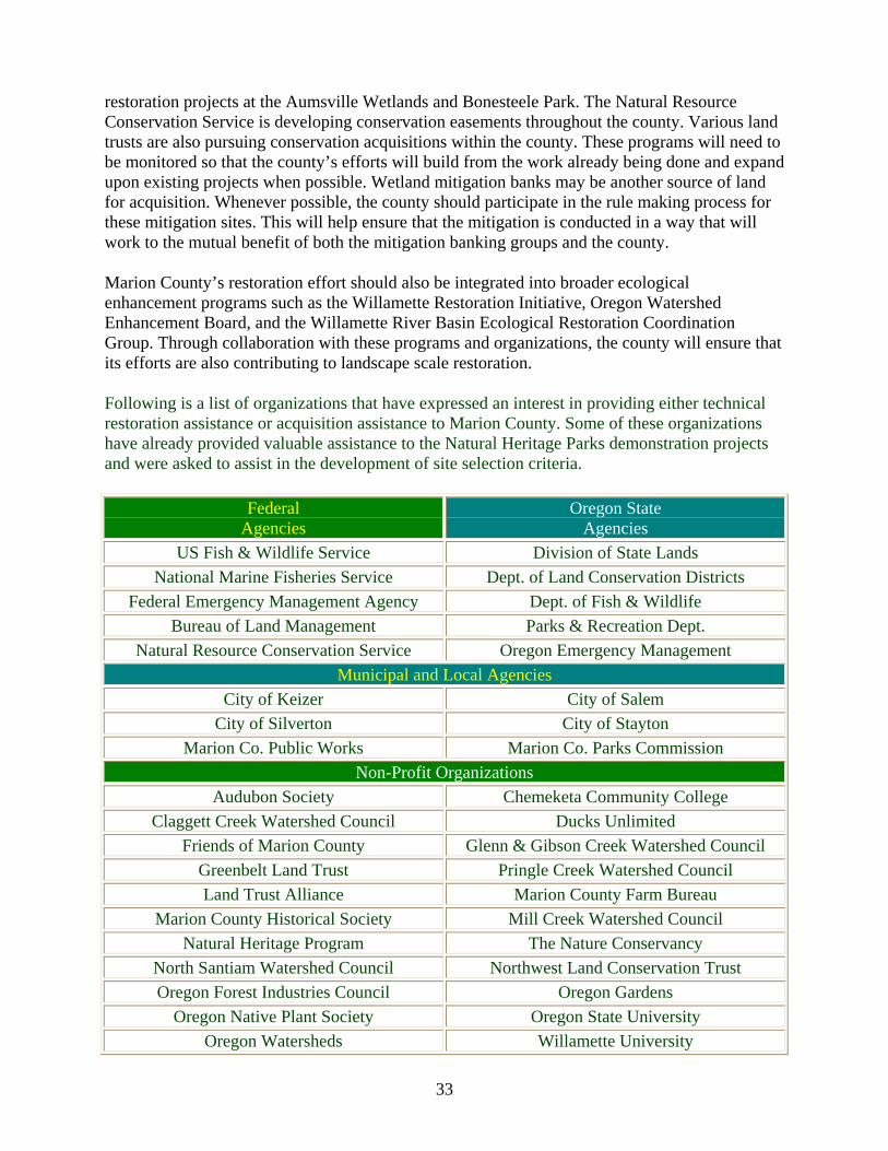
33
restoration projects at the Aumsville Wetlands and Bonesteele Park. The Natural Resource Conservation Service is developing conservation easements throughout the county. Various land trusts are also pursuing conservation acquisitions within the county. These programs will need to be monitored so that the county’s efforts will build from the work already being done and expand upon existing projects when possible. Wetland mitigation banks may be another source of land for acquisition. Whenever possible, the county should participate in the rule making process for these mitigation sites. This will help ensure that the mitigation is conducted in a way that will work to the mutual benefit of both the mitigation banking groups and the county.
Marion County’s restoration effort should also be integrated into broader ecological enhancement programs such as the Willamette Restoration Initiative, Oregon Watershed Enhancement Board, and the Willamette River Basin Ecological Restoration Coordination Group. Through collaboration with these programs and organizations, the county will ensure that its efforts are also contributing to landscape scale restoration.
Following is a list of organizations that have expressed an interest in providing either technical restoration assistance or acquisition assistance to Marion County. Some of these organizations have already provided valuable assistance to the Natural Heritage Parks demonstration projects and were asked to assist in the development of site selection criteria.
Federal Agencies
Oregon State Agencies
US Fish & Wildlife Service Division of State Lands National Marine Fisheries Service Dept. of Land Conservation Districts
Federal Emergency Management Agency Dept. of Fish & Wildlife Bureau of Land Management Parks & Recreation Dept.
Natural Resource Conservation Service Oregon Emergency Management Municipal and Local Agencies
City of Keizer City of Salem City of Silverton City of Stayton
Marion Co. Public Works Marion Co. Parks Commission Non-Profit Organizations
Audubon Society Chemeketa Community College Claggett Creek Watershed Council Ducks Unlimited
Friends of Marion County Glenn & Gibson Creek Watershed Council Greenbelt Land Trust Pringle Creek Watershed Council Land Trust Alliance Marion County Farm Bureau
Marion County Historical Society Mill Creek Watershed Council Natural Heritage Program The Nature Conservancy
North Santiam Watershed Council Northwest Land Conservation Trust Oregon Forest Industries Council Oregon Gardens
Oregon Native Plant Society Oregon State University Oregon Watersheds Willamette University

34
Funding
The potential cost of site acquisition will, of course, be a primary factor in the selection of restoration sites. Options, such as donations, ownership transfer of wetland mitigation banks, and ownership transfer of suitable state and federal lands should be actively pursued. When those options are unavailable, offering fair market value is another alternative for site acquisition. With the selection criteria in place, the County can effectively evaluate and compare sites as they become available.
Through the careful selection of lands, the use of cost-sharing programs, and the active pursuit of grants, restoration costs can be kept in check. If the funds for immediate restoration are unavailable, the restoration project can be phased in over a period of years. Restoration goals that minimize maintenance requirements by establishing sustainable native plant populations should also be emphasized. Even if restoration will be delayed, acquisition is a critical step because it allows the reduction of further disturbances and helps ensure the preservation of existing resources. Following are some examples of low-cost acquisition that the Parks program is currently examining.
Site Negotiations/Status Acquisition Costs
Mitigation Banks - 50-75 acres
Transfer after mitigation complete
Reduced or no costs
Eola Point - 287 acres Transfer after mining complete No direct costs
Process Another consideration in parkland acquisition is the process that the county must use to acquire sites and designate them as ecological restoration sites. The sites identified in this report should be considered for integration into the Marion County Comprehensive Plan. This integration will help guide natural resource management issues in the context of county planning. It will encourage ecological stewardship and streamline the acquisition process. The process for soliciting and accepting land donations should also be examined and streamlined.
VII. Further Considerations
A. Community involvement
A key component to the development and future success of the Natural Heritage Parks program is the active involvement of Marion County residents. The opinions and ideas of many county residents were already incorporated into the acquisition criteria and into the broader county goals. This type of involvement at the community level is critical to the success and long-term sustainability of a restoration program, particularly when the restoration includes recreational and educational elements. (Saunier and Meank, 1995.)
35
To maintain and encourage a high level of citizen involvement, the program decision framework accounts for public input and participation at a number of different levels. Community input will be solicited to coordinate the county’s restoration projects with other projects in the area, to help select specific sites, to evaluate the success of the restoration projects, and to actively participate in the restoration of the parklands. To facilitate this community involvement, the county has formed Citizen Advisory Councils and volunteer groups like "Friends of Bonesteele Park." The County has also worked with existing non-profit groups like the Native Plant Society of Oregon, the Audubon Society, and local watershed councils. Overseeing and guiding these efforts is the citizen-run Parks Commission. In addition to their involvement in the decision making process, area residents will be involved in developing the educational and recreational components of the Natural Heritage Parks.
* Educational opportunities
These ecological restoration sites offer many educational opportunities for area students. The Parks program has coordinated its efforts with educators around the area to provide access to the natural park areas and to share data. Already, there have been classes from the local colleges collecting topographic information and conducting plant and animal surveys at Bonesteele Park. The educational opportunities are not limited to the physical sciences, however. Students of history can find a wealth of information and experience in these restored natural heritage areas. Areas with exceptional historical significance, as indicated by the presence of artifacts or other items would be important candidates for restoration.
Whenever practical, the information developed by these students has been used by the county to evaluate its restoration projects and incorporate new ideas into future projects. There are also opportunities for area students to participate in the actual restoration of the sites. This provides the students with an understanding of restoration ecology and history and gives them a chance to make lasting, positive changes to their county.
* Recreation opportunities
These parks are intended for low-intensity recreation. They will feature natural attractions and limited facilities. The recreation most suited to these parks would include bird watching, picnicking, nature hikes, photography and other non-consumptive uses. These uses are compatible with the restoration efforts. Sufficient attention must be paid to safety and access, however. Whenever possible, the sites should be located in areas where visitors and students can easily access them. By siting parks with ease of access in mind, the parks will have more visitors taking advantage of their educational and recreational opportunities.
36
B. Program evaluation
The systematic evaluation of the Marion County Natural Heritage Parks Program is critical to its continued success. This evaluation mechanism will provide feedback for the restoration processes and the overall Parks Program. Through the information generated by this evaluation, the Parks System will be able to adjust its selection of lands, its acquisition methods, and its restoration techniques.
The evaluation will focus on the program’s success in achieving its three primary objectives: 1) provide critical habitats for rare plants and animals; 2) re-establish important environmental processes; and 3) provide visitors the opportunity for recreation, environmental education, and appreciation of the county’s natural heritage. Measurements and criteria for evaluation will be used to answer the following questions:
1. Was there an increase in biodiversity and in habitat for rare plants and animals?
Necessary information: Baseline botanical and zoological assessments Check against desired ecological community portfolio Annual monitoring of population changes on site
Collection methods: Cooperative program with Chemeketa Community College, Willamette University, Native Plant Society, Audubon Society, Oregon Department of Fish and Wildlife
2. Have environmental processes been enhanced on the restoration sites?
Necessary information: Baseline survey of water quality, site hydrology & environmental concerns, including erosion, landslides, land use patterns, water temperature, microclimate conditions, etc.
Collection method: Annual monitoring of environmental process changes
Cooperative program with Chemeketa Community College, Willamette University, possibly DEQ, DSL, NRCS or other agency
3. Is the park receiving a satisfactory number of visitors? Have visitors to the site learned about the area’s ecology or history & enjoyed their recreation opportunities?
Necessary information: Visitors and workers’ activities and assessments
Collection method: Survey visitors, volunteer workers, students, and involved citizens Possibly through self administered surveys sponsored by the county
These evaluations of the program’s objectives should be conducted annually and compiled in the Natural Heritage Parks annual report. The Natural Heritage Park program processes should also undergo an annual evaluation. Elements for consideration in the process evaluation should include:

37
1) Analysis how effectively the program allocated resources toward its different objectives,
2) The presence of common issues in the various site acquisitions and restoration,
3) What type of feedback have the community and natural resource management professionals offered about different elements of the acquisition and restoration process, and,
4) Whether the decision model still accurately reflects the actual decision process used in the selection, acquisition, and restoration process.
By necessity, the program will have to follow the adaptive management approach - working within a structure of goals and objectives, but adapting to new opportunities or unforeseen issues. Just as the site identification decision model allows for the inclusion of new criteria and a changing emphasis on criteria, so should the evaluation structure allow for a changing emphasis in program elements.
C. Decision model limitations
Although the decision model provides a logical structure for the identification of sites with restoration potential, in its present form it has certain features that limit its application. One primary drawback of the current model is that it does not allow the isolation of specific criteria to determine how those criteria affect a given site. For example, the model cannot explicitly demonstrate how the "proximity to county roads" criterium affects the value of site X. It can only show the aggregate value of that site based on all of the criteria in a particular category model. Without a clear understanding of how each criterium affects each site, the decision of that site’s value may not account well for unusual situations. This problem is being addressed for later versions of the Plan.
Another shortcoming of the model is the numeric values of certain criteria. Because these features sometimes lacked quantifiable values, (e.g. Is a site within 250' of an endangered species twice as valuable as a site within 500' of an endangered species?) the values were developed from the judgments of natural resource professionals using relative valuations rather than from directly quantifiable differences.
Perhaps the most significant drawback to the decision model was the limited amount of spatial data that could be integrated into criteria layers. While the existing data did allow the consideration of a number of important objectives the data were limited in how they could be used to express those desired attributes. In another example of data limitations, the ODFW current vegetation layer that served as a base map was already a 4 to7 years old and may not accurately reflect the current conditions in all areas of the county - particularly those areas with recent development. Also, the data layers used in this analysis were often limited to the Willamette Valley region of Marion County and did not include much of the Cascade foothills and mountains.
Finally, there is still a great deal that we simply do not know about pre-EuroAmerican settlement ecosystems. Comparing current ecosystems to pre-settlement ecosystems is still speculative - even though biologists from ODFW have begun an in-depth analysis of the comparison between

38
them. While general conditions can be emulated, the specific ecologies of these systems require additional research.
Despite these limitations, this decision model represents a starting point for more sophisticated analysis of parkland selection and related natural resource management decisions. Using a similar decision structure, but one that accounts for this model’s shortcomings, will generate increasingly accurate parkland identification maps.
VIII. Conclusions
Marion County may be able to enhance the level of service in its park system by providing additional, low-cost recreation parkland. To increase the value of a given site, the site should provide benefits beyond traditional recreation. Using these sites for ecological restoration can help provide those secondary benefits while also offering high-value, nature-oriented recreation.
Ecological restoration addresses the loss of its historical ecosystems. In the past, these systems provided important ecological and environmental functions. Today, a few remaining ecosystems continue to enhance the county’s environmental quality and also serve as monuments to Marion County’s natural heritage, albeit in a limited way. Without the restoration of additional sites to these conditions, the county can expect reduced biodiversity and degraded environmental quality, as well as limited educational and recreational opportunities. By taking an active approach to the restoration of these ecosystems, Marion County can recover and preserve critical sites before they are further disturbed, or lost entirely.
The sites identified in this report are the result of using a decision framework that has been developed specifically for future parkland acquisitions. Through the use of this framework, other sites can also be identified and examined for their potential inclusion in Marion County’s park system. The decision framework ensures that important selection criteria are not overlooked during the decision process. With careful consideration, future park sites can provide high-quality, nature oriented recreation while also contributing to the environmental and historical quality of the county.
Through the restoration of these sites, Marion County can effectively recover some of its unique historical landscapes. These parks will provide ecological preserves for rare plant and animals while also offering important educational and recreational opportunities. The parks will fit closely with the goals of the county’s long-term plans, and represent an important step toward restoring some of Marion County’s natural heritage.

39
Bibliography
Alverson, Edward R., (1990) A Test of the Soil Survey Method for Locating Native Grassland Remnants in the Willamette Valley, Oregon. The Nature Conservancy, Arlington. Virginia.
Berger, John J. ed., (1990) Environmental Restoration: Science and Strategies for Restoring the Earth. Island Press. Washington D.C.
Boyd, Robert. ed. (1999) Indians, fire, and land in the Pacific Northwest. Oregon State University Press. Corvallis, Oregon.
Cairns, John, Jr. ed. (1994) Rehabilitating Damaged Ecosystems. Lewis Publishers, London.
Department of Land Conservation and Development..(1995) Oregon Statewide Planning Program. State of Oregon. Salem, Oregon.
Gilbert, Oliver L., Anderson, Penny. (1998) Habitat Creation and Repair. Oxford University Press, Oxford.
Groves, Craig. and Valutis, Laura. ed. (1999) Guidelines for Representing Ecological Communities in Ecoregional Conservation Planning. The Nature Conservancy. Arlington, Virginia.
Hulse, David. ed. (1998) Willamette River Basin: A Planning Atlas. Institute for a Sustainable Environment, Eugene, Oregon.
Marion County, Marion County Comprehensive Plan. (1981, w/ later revisions) Marion County Planning Department. Salem, Oregon. www.co.marion.or.us/~mcplann/compplan/intro.htm
Maybury, Kathleen P., ed. 1999. Seeing the Forest and the Trees: Ecological Classification for Conservation. The Nature Conservancy, Arlington, Virginia.
Oregon Biodiversity Project, (1998) Oregon’s Living Landscape: strategies and opportunities to conserve biodiversity, Defenders of Wildlife. Portland, Oregon.
Petterson, David L., Klimas, Charles D., (1996) The Role of Restoration in Ecosystem Management. The Society for Ecological Restoration.
Poiani, Karen. Richter, Brian. (1999) Functional Landscapes and the Conservation of Biodiversity. The Nature Conservancy. www.tnc.org
Saunier, Richard E. and Megnack, Richard A. eds. (1995) Conservation of Biodiversity and New Regional Planning. IUCN, World Conservation Union. Gland, Switzerland.
U.S. Army Corps of Engineers. (1999) Willamette River Basin, Oregon, Floodplain Restoration Project. Portland, Oregon.

40
Willamette Restoration Initiative. (1999) Endangered Species Act Issue Paper: Parks and Natural Areas. Draft. ESA Urban Parks and Natural Areas Paper. www.oregonewri.org/basin_restore/parkspaper.htm
Williams, J.E., C.A. Wood, and M.P. Domeck, ed. (1997) Watershed restoration: principles and practices. American Fisheries Society, Bethesda, Maryland.

41
APPENDICES:
Appendix A: Listing of threatened plants and animals found in Marion County
List derived from Oregon Natural Heritage Program database 1999. The locations for these species were identified and weighted within the parkland selection process.
Scientific Name Common Name DRILOLEIRUS MACELFRESHI OREGON GIANT EARTHWORM TINODES SISKIYOU SISKIYOU CADDISFLY CERACLEA VERTREESI VERTREES'S CERACLEAN
CADDISFLY LOMATIUM BRADSHAWII BRADSHAW'S LOMATIUM ASTER CURTUS WHITE-TOPPED ASTER ASTER GORMANII GORMAN'S ASTER ERIGERON DECUMBENS VAR DECUMBENS WILLAMETTE VALLEY DAISY HOWELLIA AQUATILIS HOWELLIA LUPINUS SULPHUREUS SSP KINCAIDII KINCAID'S LUPINE CORYDALIS AQUAE-GELIDAE COLD-WATER CORYDALIS ROMANZOFFIA THOMPSONII THOMPSON MISTMAIDEN SIDALCEA NELSONIANA NELSON'S SIDALCEA (Checkermallow)CIMICIFUGA ELATA TALL BUGBANE DELPHINIUM LEUCOPHAEUM WHITE ROCK LARKSPUR DELPHINIUM OREGANUM WILLAMETTE VALLEY LARKSPUR HORKELIA CONGESTA SSP CONGESTA SHAGGY HORKELIA CASTILLEJA LEVISECTA GOLDEN INDIAN-PAINTBRUSH MIMULUS TRICOLOR THREE-COLORED MONKEYFLOWER SISYRINCHIUM SARMENTOSUM PALE BLUE-EYED GRASS CALAMAGROSTIS BREWERI BREWER REEDGRASS LYCOPODIUM COMPLANATUM GROUND CEDAR BOTRYCHIUM MONTANUM MOUNTAIN GRAPEFERN BATRACHOSEPS WRIGHTI OREGON SLENDER SALAMANDER RANA PRETIOSA OREGON SPOTTED FROG BRANTA CANADENSIS LEUCOPAREIA ALEUTIAN CANADA GOOSE HISTRIONICUS HISTRIONICUS HARLEQUIN DUCK HALIAEETUS LEUCOCEPHALUS BALD EAGLE PROGNE SUBIS PURPLE MARTIN

42
OREGONICHTHYS CRAMERI OREGON CHUB MYOTIS VOLANS LONG-LEGGED BAT CORYNORHINUS TOWNSENDII TOWNSENDII PACIFIC WESTERN BIG-EARED BAT GULO GULO LUTEUS CALIFORNIA WOLVERINE CHRYSEMYS PICTA PAINTED TURTLE CLEMMYS MARMORATA MARMORATA NORTHWESTERN POND TURTLE
43
Appendix B: Marion County Comprehensive Plan (relevant language)
The following goals and policies are taken from the Marion County Comprehensive Plan. These are the goals and policies most relevant to the Natural Heritage Parks Plan. For a complete version of the Comprehensive Plan, contact the Marion County Public Works Planning Office, or visit their web site at: http://www.codepublishing.com/OR/marioncounty/
Marion County Comprehensive Plan
Goals and Policies:
Parks and Recreation
Recreation Goals
To define a desirable future condition and to outline the ideal rural park system for Marion County. A successful park's program should contribute to the fulfillment and the leisure time needs of the citizens and to the aesthetic qualities of the area through creative leadership, facilities, and public open spaces that encourage individual satisfaction and generate community pride.
Recreation Sub Goals
a. To identify and measure the needs and desires of the area's residents for park and recreational facilities and programs.
b. To preserve and protect areas of unique natural and scenic importance for their original and intrinsic value.
c. To maintain a relationship with our past through retention of historical sites and structures.
d. To provide a system of multi-purpose parks for active and passive recreation.
e. To provide for the unique and recreational needs of the young, the aged, and the handicapped.
f. To recognize and provide for special use areas and facilities not normally found in urban parks.
g. To incorporate the ideal of environmental protection and stewardship of natural resources into acquisition and development of facilities.
h. To optimize use of the public dollar through cooperative and coordinated facility acquisition and development.
i. To provide for increased public access to rivers of the area and to encourage such uses as fishing, boating and swimming.
44
j. To recognize and encourage private recreational facilities that help semi-public needs and are compatible with the goals and policies of Marion County.
General Policies
1. Site selection should take into consideration topographic and physical features, water areas, wooded areas, etc.
2. There shall be a balance between day use facilities for social interactions and natural, scenic areas for serenity and solitude.
4. Parks and open space areas should retain natural vegetation as much as possible to provide habitat for wildlife.
General Outdoor Parks
5. The County shall have the responsibility of providing these parks.
6. These types of parks should be provided near urban and urbanizing areas whenever possible.
7. These parks should provide an escape from the daily routine.
10. Facilities within a park may be adjusted to meet the needs and desires of an area and character of the site.
Scenic Ways
38. Should provide:
a. Linear areas of natural beauty connecting parks, schools, and other public places.
b. Conservation of scenic and natural beauty.
c. Buffers to thoroughfares and conflicts land uses.
38. (1) The County shall cooperate and work with National Park Service, other involved agencies and property owners during the inventory and designation phases of the Wild and Scenic Rivers program to provide relevant information. If any rivers are formally designated as Wild and Scenic Rivers the County shall determine if there are any conflicts related to Wild and Scenic River System designations and develop a program to resolve any identified conflicts.
Historical Sites
50. In an effort to designate and preserve buildings and sites of special historic, cultural or architectural interest, Marion County shall adopt a special review process for building permits and land use applications. The process is designed to minimize land use conflicts involving Historic Sites. Those structures and parcels subject to this review are listed in the Background Report and are identified on the Parks and Recreation map of the Plan.

45
51. The County shall encourage identification of all buildings, sites, and county parks with historic significance to show those areas as places of public interest and to pay tribute to that history.
52. The County will encourage the State to acquire, renovate, and maintain areas of regional or statewide interest.
53. The County will encourage historical organizations to acquire, renovate, and maintain areas of local interest.
Open Space
54. Multiple use of lands such as those adjacent to reservoirs, land reclamation sites, power line rights-of-way, flood control areas, public transportation rights-of-way, under overpasses, etc., are encouraged as open space providing public health and safety standards are met.
56. Encourage much of the land adjacent to the UGB be preserved as open space.
58. Encourage preservation of lands adjacent to major streams as open space.
59. Tree preservation and planting to separate conflicting uses and provide scenic and recreational opportunities and should be encouraged whenever feasible.
60. Scenic, natural and historic sites should be preserved and utilized as open space.
Parks and Recreation Objectives
The Regional Parks and Recreation Agency has proposed the following objectives (summarized in the following table - author.) for the development and location of additional recreational facilities in the County. These recommendations will be placed in priority and the implementation plan will proceed as funding becomes available. They are the result of applying the standards and policies to the conditions in Marion County.

46
Recommendations made in 1981 for park land acquisitions. These sites have not been acquired.
Acreage Location
20 Pudding River, near Aurora
20 Hubbard area
120 Jackson-Lambert Bend area (river mile 64-65) possibly state agency
10 Adjacent to Spongs Landing
40 North and West of Joryville
10 Adjacent to Joryville Park
28 5-10 miles down river from Buena Vista, near Junson Rocks area
55 Stiener Hill - Miller Butte vicinity
12 South of Silverton, near reservoir
15-25 Abiqua Creek, north of Silverton
340 Total recommended acquisitions in 1981 that have not occurred
1337 Extrapolated total parkland (county-type only) needed for a county population of 272,760 (1999 est.) (Acre figures derived from Comp. Plan assessment of land holdings and recommendations for acquisition)
47
ENVIRONMENT ENVIRONMENTAL QUALITY AND NATURAL RESOURCES
INTRODUCTION
The quality of life in Marion County is directly related to the quality of the physical and natural environment. Marion County presently has relatively high quality air, water, and land resources. Man's relationship to and use of these key physical elements comprise the land use issues of environmental quality. In considering land use possibilities and alternatives, affect on the physical environment and natural resources are of significant importance. The goal of environmental quality planning in Marion County is: The property use and management of our air, land, and water resources to maintain our physical, social, and economic well-being.
FISH AND WILDLIFE HABITAT
The discussion of fish and wildlife habitat issues emphasizes that continued production of fish and wildlife is directly dependent on the quality of the natural environment. With awareness of the environmental needs of fish and wildlife, care can be exercised in reviewing developments in rural areas of Marion County, which will remain in agriculture and forestry uses, thereby achieving most of the protection needs of this habitat. The Marion County goals and policies in regard to protecting fish and wildlife habitat are:
GOALS
Protect fish and wildlife habitat, maintain optimal ecological balance and protect endangered species.
POLICIES
3. To maintain stream quality and protect sensitive waterfowl areas, land uses that require drainage, excessive removal of riparian vegetation, alteration of stream banks and filling shall be discouraged in these locations.
4. Conflicts with wildlife (especially big game) shall be considered in land development. Development adjacent to streams, sensitive waterfowl areas and critical wildlife areas shall incorporate adequate setbacks and buffer zones.
8. Marion County will cooperate with local, state and federal agencies to identify, conserve and protect fish and wildlife habitat and in implementation measures for the protection of such areas.
9. Native plant species, wetlands and stream bank vegetation on County managed public lands shall be protected.

48
NATURAL AREAS
Ecologically and scientifically significant Natural Areas contain components that are unique to that area and location and cannot be relocated. It is the objective of the State and County to preserve and protect sections of these ecologically diverse components before they are forever lost or altered. The Oregon Nature Conservancy, under contract with the Land Conservation and Development Commission, prepared a data summary of Natural Areas in Marion County. The inventory includes all areas noted for their natural values, whether or not they have been fully verified or evaluated. A total of 31 sites were identified but Minto Island was deleted because it is covered in the Salem Area Comprehensive Plan. McKinney Bottom Heronry and Talbot Heronry were also omitted because they are located in Linn County. The identified natural areas that primarily are significant because of their value as natural habitat are discussed below. The remaining areas identified by the Nature Conservancy that predominately have a scenic or recreational character are discussed in the Parks and Recreation Section.
Candiani Island - Candiani Island is a 40 acre island in the Willamette River approximately four miles west of St. Paul. The island is essentially composed of three district vegetation communities. In one of these, a stand of tall cottonwoods, lies a great blue heron rookery. Another is a small slough with wapato, a species of concern. Candiani Island is a peaceful place little touched by human activity.
The older upstream portion of the island is occupied primarily by cottonwood with canary grass in small amounts of nettle and nightshade grading into ash and willow along the stream banks. This area is a nesting habitat for 50 pair of great blue heron and a few raptors. The slough on the east side of the island, which is nearly dry by late August, sustains willow and canary grass, with wapato and knotweed in wetter areas.
Independence Bend - This habitat area is northeast of Independence and consists of a wooded area along the Willamette River that is 1.5 miles long and consists of 60 to 75 acres. It is a wintering area for geese in addition to being a great blue heron rookery.
Ankeny Osprey Nest - This American Osprey habitat area is located four miles downstream from Buena Vista and is adjacent to the Ankeny National Wildlife Refuge. The trees near the river are valuable for shelter and nesting.
Ankeny National Wildlife Refuge - This 2,750 acre refuge is within the Willamette River flood plain east of Buena Vista. It also includes the Ankeny Bottom waterfowl wintering area identified by Nature Conservancy. This important habitat is owned and managed by U.S. Fish and Wildlife Service. Waterfowl and birds of prey are among the major types of wildlife protected by this refuge.
Tyson Island - This Willamette River island of approximately 50 acres is situated 2.5 miles south of the Independence Bridge. The eastern half of the island is under cultivation and the riparian vegetation on the west side of the island provides excellent habitat for a great blue heron rookery and birds of prey. The western half of the island appears to be publicly owned.
49
Stout Mountain Rattlesnake Dens - Stout Mountain is located two miles west of Mehama and one mile north of Highway 22. The dens are considered by the Nature Conservancy to be among the best traditional rattlesnake dens in the Willamette Valley.
Little North Fork and North Santiam Rivers Confluence - This area consists of riparian habitat that is located between the two rivers.
North Santiam River Flood Plain - This area situated between Stayton and Jefferson contains numerous old stream channels and oxbow lakes. Riparian vegetation and habitat is abundant and relatively untouched and surrounded by farmland.
Giesy Mineral Springs - These springs are located 1.5 miles west of Aurora, north of the intersection of Boones Ferry Road and Donald Road.
Breitenbush Hot Springs- These springs are situated near the Breitenbush Lodge, on private land, approximately 10 miles northeast of Detroit. Band-tailed pigeons are found in the vicinity of the springs.
Candiani Island, Independence Bend, Ankeny Osprey Nest and Tyson are currently regulated by the County with the EFU (EXCLUSIVE FARM USE) zone, the Willamette River Greenway Overlay Zone and the County Floodplain Ordinance. The EFU zone and the Floodplain Ordinance both act to limit the intensity and type of development in the area. It is unlikely that any permitted or conditional use could be allowed that would have a detrimental impact upon these natural areas. In addition, the Greenway Ordinance contains provisions for the protection of habitat areas along the river and gives the County and several State agencies review authority over stream bank and vegetation alterations. As a result, these areas are adequately protected and no additional regulation or protective mechanism needs to be established.
The Ankeny National Wildlife Refuge is adequately protected by the U.S. Fish and Wildlife Service. Also, the EFU zone that applies to the refuge and the surrounding areas provides an additional safeguard in terms of incompatible uses located nearby.
The Stout Mountain Rattlesnake Dens are primarily protected from incompatible uses by the EFU zone. The dens are located in an area of poor agricultural soil and rock outcroppings and therefore farming activity in and around the dens is not feasible. The dens are adequately safeguarded by the zoning, the soils and terrain and the nature of the animal.
The confluence of the Little North Fork of the North Santiam River are basically protected by the EFU and TC zones and the County Floodplain Ordinance. A small potion of the confluence of the rivers is zoned AR (ACREAGE RESIDENTIAL) but a cliff effectively separates potential and existing home sites from the habitat area. The Forest Practices Act would cover any large scale timber harvest and sale, thereby maintaining the integrity of the river bank vegetation. These three regulations should effectively protect these habitat areas.
Giesy Mineral Springs and Breitenbush Hot Springs are zoned EFU and P (PUBLIC) respectively and are both in private ownership. A resort including a lodge and cabins has been near the hot springs since the 1920's. It is not apparent from the Nature Conservancy inventory that any measures need to be taken beyond the existing zoning control and review to protect the

50
springs and the pigeons. Since the established uses of the springs do not appear to have affected their value as natural areas, no additional protection is necessary.
Natural Area Policies
1. When land use changes are proposed in the vicinity of identified natural areas, possible conflicts shall be identified and evaluated as to their social, economic, environmental and energy consequences. Significant conflicts shall be resolved in accordance with state land use Goal 5 requirements.
2. As new natural areas are proposed they will be reviewed and if determined to be ecologically and scientifically significant shall be protected in accordance with Goal 5 requirements prior to the next Plan update.

51
Appendix C: Criteria descriptions and GIS integration
Base layers
The Geographic Information System (GIS) analysis of areas with parkland potential began with two base layers. The first layer, pre-EuroAmerican settlement ecosystems was developed by the Natural Heritage Program from General Land Office records, survey notes, plat books, and other early settlement sources. The second layer, current vegetation, was developed by the Oregon Department of Fish and Wildlife through ground surveys and air photo interpretation. These two data layers offered a comparison between the pre-settlement conditions and current conditions.
An intersection of these layers indicated that there are few sites in Marion County where the land remains relatively unchanged, and even fewer of significant size. These sites were favored in the GIS model due to their preservation value. There are a number of pre-settlement ecosystems that no longer even exist in current conditions - at the same location. A number of the pre-settlement ecosystems, however, do exist in different locations. Rather than limit the potential acquisition sites to only those locations that once held these ecosystems, the selection process focused on existing areas with restoration potential. The pre-settlement data was used as a reference for size, distribution, and composition of the desired restoration scenarios rather than a specific locator.
Criteria layers
The criteria used to identify sites with restoration potential were developed from a diverse array of data sets (see following table). These data sets allowed the desired parkland attributes to be expressed through the selection process. The criteria were reviewed by natural resource management professionals, stakeholders, and interested citizens. New data sets, from satellite imagery, are also under development and will provide a higher level of precision in the application of these criteria.
The criteria were built into a GIS decision model, using the current vegetation data layer as the base map. The model takes each criteria layer and assigns a value to the desired attributes within that layer. For example, within the School Layer the closer that a site occurs in relation to a school, the higher the value for that site. Since one goal in establishing these parks is to provide educational opportunities, a site close to a school better meets that goal and receives a higher value. A similar process is conducted for each data layer. Some of the criteria layers reduce the selection potential of certain areas, such as highly productive agricultural land or industrial areas. This is done either because the areas are unsuitable for restoration or because the areas currently contain other valuable uses.
Overlay process
The criteria layers were then assigned a weight, based on their relative value, and combined to produce a map of the cumulative values for every potential site in the county. By the end of the process, certain areas have accumulated higher values than others thus indicating areas with higher selection potential. This map of values was then overlain on the current vegetation layer. This overlay indicated the areas of highest value park potential and the current condition of the land. Over this map was laid the pre-settlement vegetation map, providing the target restoration scenario for the high value sites. Thus, this final map highlights the most valuable potential park

52
sites, shows the current land cover conditions of those sites, and indicates the possible restoration ecosystems.
Further analysis
The maps resulting from these criteria and base layers indicate the areas of desired vegetation types which also have a high value assigned through the criteria model. The sites that were identified through this process will be further refined through ground-truthing and an aerial survey. The maps were adjusted according to the findings of these surveys.
As our understanding of the Marion County’s natural resource base grows, and as other restoration programs develop in the Valley, the analysis used for site identification will need to be adjusted. New imagery that provides higher resolution data, new data sets that outline important natural resource management elements, such a flood control areas and groundwater draw-down concerns will need to be added to the model. This will increase the accuracy of selection and the value of the sites to many different goals.

53
Criteria (data layers) and their intent attribute values and relative influence.
Criteria Categories
Data Layers Intent
Buffer Widths &
Labels
WeightedValues
Data Origin
Preservation Areas
Endangered Species Protect threatenedplants and animals
0-250', 250-500' 11% NHP
Salmonid Distribution
Protect threatened salmonid pops. 0-200' 11% ODFW
Natural Areas Protect significant natural areas 0-500' 5% Comp
Plan
Scenic Areas Protect identified scenic areas 0-500' 5% Comp
Plan
Archeology Sites Protect areas with historical sig. 0-500' 3% Comp
Plan
Level of Disturbance
Protect areas with the least disturbance
High to Low levels of disturbance
11% Derived
Future development projections
Preserve sig. areas in the way of development
Within preservation areas
4% U of O
Hydrology
Hydrology (surface water)
Protect exposed water bodies
0-250', 250-500' 6% County
DEQ 303d Contaminated Streams
Buffer areas with water quality issues 0-200' 6% DEQ
100 Year Flood Plain
Flood abatement & development limitation Within floodplain 6% FEMA

54
Hydric Soils Protect potential wetland areas 0-100' 6% NRCS
Soils
Erosion model Provide permanent vegetation cover
High to Low erosion potential
4% Derived
Landslide areas Reduce development of inappropriate areas
High to Low landslide potential
6% Salem
Land Use/ Location
City Limits
Provide natural settings near population centers
0-500' 2% County
Urban Growth Boundary
Provide accessible recreation & prevent sprawl
0-2500' 2% County
Schools Provide easy access for educational uses 0-1 mile 1% County
County Roads Provide easy access for visitors 0-250' 1%
Ag Land Preserve ag productivity & protect quality farm land
High to Low productivity 2% NRCS
Ownership
County Parks
Build on properties already in County ownership
0-500' 3% County
County Property Build on properties already in County ownership
0-500' 3% County

55
Public Property Coordinate land management with other agencies
0-500', 500-1000' 2% County
TOTAL 100%

56
Appendix D. Initial Field Assessment for Natural Heritage Park Candidate Sites
Date: ________________ Assessor: ____________________________________
Ownership: _________________ Ease of Access:______________________________
Site Location: (T,R,S)____________Watershed:________________________________
Driving Directions: _______________________________________________________ _______________________________________________________
Pre-EuroAmerican ecosystem: _____________________________________________
***************************************************************************
Estimated Site Size: _______________ Topography and aspect: _________________
Soil type: ____________________________________________________________
Flowing/Standing water on site: ____________________________________________
Evidence of drainage: ___________________________________________________
Wetland indicators: Primary _______________________________________________
Secondary ______________________________________________
Anticipated hydrology: ___________________________________________________
____________________________________________________________________
***************************************************************************
Evidence of disturbance: ________________________________________________
____________________________________________________________________
____________________________________________________________________
Current use of site: _____________________________________________________
Past use of site: _______________________________________________________
Surrounding land use: _________________ Areas of special concern: _____________
****************************************************************************

57
Major plant associations and % of area they occupy: _______________________
____________________________________________________________________
____________________________________________________________________
____________________________________________________________________
____________________________________________________________________
____________________________________________________________________
____________________________________________________________________
____________________________________________________________________
Threatened and Endangered Plants or Animals : _______________________________
Noxious Weeds / Invasive Exotics : (on site) ___________________________________
_____________________________________________________________________
_____________________________________________________________________
(primary weeds on surrounding properties) ____________________________________
_____________________________________________________________________
***************************************************************************
Wildlife: _______________________________________________________________
***************************************************************************
Additional, unique characteristics of site: ______________________________________
_____________________________________________________________________
Additional notes: ________________________________________________________
_____________________________________________________________________
_____________________________________________________________________
_____________________________________________________________________
If possible, rough sketch the area on the back of this sheet.

58
Appendix E: Society for Ecological Restoration Project Policies
http://www.ser.org
The following recommendations from the Society for Ecological Restoration offer a good starting point for restoration efforts within Marion County. The recommendations will, of course, need to be modified to fit with the overall goals of the County and the limitations of its restoration efforts. The basic concepts presented here, however, warrant close consideration as they can affect not only the restoration process but also acquisition decisions.
Published in Restoration Ecology 2(2): 132-133, 1994.
I. Restoration Plans
The Society for ecological restoration advises that plans for restoration projects should contain, at a minimum, the following items:
1. A baseline ecological description of the ecosystem designated for restoration that accounts for the regional expression of that ecosystem in terms of the biota and poignant features of the abiotic environment.
2. An evaluation of how the proposed restoration will integrate with other components of the regional landscape, especially those aspects of the landscape that may affect the long-term sustainability of the restored ecosystem.
3. Explicit plans and schedules for all on-site preparation and installation activities, including plans for contingencies.
4. Well-developed and explicitly stated performance standards, by which the project can be evaluated objectively.
5. Monitoring protocols by which the performance standards can be measured.
6. Provision for the procurement of suitable planting stocks and for supervision to guarantee their proper installation.
7. Procedures to expedite promptly any needed post-installation maintenance and remediation.
II. Exotic Species at Restoration Sites
An exotic species of plant or animal is one that was introduced, either intentionally or unintentionally, by human endeavor into a locality where it did not previously occur. The invasiveness of exotic species of plants and animals challenges a basic goal of ecological restorationists to recreate environments like those that existed prior to widespread human existence. Ideally, a restoration project should consist entirely of indigenous species. In order to meet this goal for virtually all restoration projects the control of exotic species will require ongoing management, monitoring, and evaluation. To that end, the Society for Ecological

59
Restoration recommends the following principles be followed during the planning, implementation, and evaluation of restoration projects and programs:
1. The control of exotic species should be an integral component of all restoration projects and programs.
2. Monitoring of exotics and periodic reassessment of their control should be integrated into all restoration plans and programs.
3. Highest priority should be given to the control of those species that pose the greatest threats, namely:
• Exotics that replace indigenous key (keystone) species. • Exotics that substantially reduce indigenous species diversity, particularly with respect to
the species richness and abundance of conservative species. • Exotics that significantly alter ecosystem or community structure or function • Exotics that persist indefinitely as sizable, sexually reproducing or clonally spreading
populations. • Exotics that are very mobile and/or expanding locally.
4. Restoration plans and management programs should include contingencies for removing exotics as they first appear and for implementing new control methods as they become available.
5. Control programs should cause the least possible disturbance to indigenous species and communities and, for this reason, may be phased in over time.
6. The restoration and management program must be strategic. Protection of indigenous habitats, levels of infestation, appropriate resource allocation, and knowledge of control methods should be integrated into the monitoring and management program.
7. Exotic species should not be introduced to the site in the restoration plan.
8. Native species should also be evaluated for their potential threat to indigenous communities. Weedy native species should be avoided in restoration plans as well as native planting stocks representing non-indigenous ecotypes.
I. Integration of Ecological Restoration into a Larger Project:
Ecological restoration is sometimes only one of many elements within large enterprises, such as regional development projects and resource management programs. Managers of these larger undertakings should be aware of the complexities involved in planning and implementing ecological restoration and of the cost savings that are realized by careful coordination of larger projects to adopt the following recommendations:
1. Ecological restoration should be integrated into development projects and implemented in cooperation with all members of the development team.

60
2. Project managers should agree in advance that ecological restoration is a major component of an overall development project, and that the restoration team shall be given equal status with other key project personnel.
3. Project managers should ensure that key personnel avoid advocacy and work together to achieve consensus on decisions.
4. Definitions and policies of the Society for Ecological Restoration should be utilized in the consensus making process.
5. Cooperative decision making should include the following steps:
• Develop feasible and effective alternatives for remediating environmental problems • Include stakeholders (people who are affected by the alternatives) in the process of
anticipating the potential adverse social and ecological consequences of alternatives. • Modify the alternatives as necessary to mitigate potential adverse consequences prior to
implementation. • Build consensus among key stakeholders on a preferred alternative.
IV. Regional Ecotypes
The Society for Ecological Restoration advocates the planting of regional ecotypes at restoration project sites to assure the fitness of the planting stock and to preserve genetic integrity in local species populations, especially for species verging upon local extirpation. The procurement of suitable planting stock should not jeopardize existing populations of rare taxa.
V. Landscape Interactions
The Society for Ecological Restoration recognizes that regional landscapes frequently contain two or more interacting ecosystems. For example, hydrologic transfer from upland ecosystems determines water quality, quantity, and rate of discharge into wetland ecosystems. Therefore, landscape functions and limitations should be considered in planning restoration projects.
VI. Local Stewardship
The Society for Ecological Restoration advises that restoration plans should be keenly sensitive to local concerns. Local acceptance and assistance should be solicited in the planning process, because, among other reasons, local residents will likely serve as stewards of the restored ecosystems.