Embed Size (px)
Citation preview
E-proceedings of the 36th IAHR World Congress 28 June – 3 July, 2015, The Hague, theNetherlands
1
NATURAL FORESHORES AS AN ALTERNATIVE TO TRADITIONAL DIKE RE-ENFORECEMENTS: AFIELD PILOT IN THE LARGE SHALLOW LAKE MARKERMEER, THE NETHERLANDS
W.E. PENNING(1), H.J. STEETZEL(2), R. VAN SANTEN(3), J. FISELIER(4), H.J. DE LANGE(5), V.VUIK(6), S.OUWERKERK(7), J.S.M. VANTHIEL DE VRIES(8)
(1) Deltares, Delft, The Netherlands, [email protected](2) Arcadis, Zwolle, The Netherlands, [email protected]
(3) Arcadis, Zwolle, The Netherlands, [email protected](3) Royal Haskoning-DHV, Amersfoort, The Netherlands,[email protected]
(3) ALTERRA Wageningen UR, Wageningen, The Netherlands,[email protected] (3) HKV – Lijn in Water, Lelystad, The Netherlands, [email protected]
(3) HKV – Lijn in Water, Lelystad, The Netherlands, [email protected](3) Ecoshape, Dordrecht, The Netherlands, [email protected]
ABSTRACT
Natural foreshores are shallow zones and beaches with a gradual slope and a (near-)natural vegetation that can be usedas an additional protection against flooding by reducing the wave attack on existing dikes, or can even completelyreplace an existing dike system. In order to test the applicability of this concept a 500 m long pilot section of a sandyforeshore was constructed along an already existing dike in the large shallow lake Markermeer, the Netherlands. Thepilot was equipped with permanent monitoring equipment for hydrodynamics and meteorological conditions and monthlysurveys of the morphology of the pilot section. These measurements will be carried out for the coming four years. Thispaper presents the first results after the construction and the first winter season with the pilot in place.
Keywords: Building with Nature, Natural Flood Defence, dike re-enforcement, coastal morpho-dynamics, vegetated foreshores
1. INTRODUCTION
Increasingly, natural foreshores are seen as a valuable alternative for, or addition to conventional dikes. Naturalforeshores consist of shallow zones and beaches with a gradual slope and a (near-) natural vegetation, e.g. freshwaterreedbeds and wetlands, willow forests, salt marshes and mangroves. They create an additional protection againstflooding by reducing wave attack on dikes or can even protect the dike completely from being attacked (Borsje et al.,2011). Using wide beaches and dunes is common practice as a coastal flood defense solution in the Netherlands.However, so far, this approach is not applied inland at i.e. the larger delta lakes in the Netherlands. The shorelines ofthese lakes are at present protected by dikes, some several centuries old and important cultural historic monuments.Recently a discussion has started where the use of natural foreshores is considered as an alternative way to assuresafety against flooding in the coming decennia (Van Slobbe et al., 2013). This option is considered for various reasons.One is to spare the older dikes which otherwise would have to be completely rebuilt because of problems with macro-instability. But a soft defense may also offer a more cost-effective and also more flexible alternative. A soft defensealong these larger lakes is a novelty and natural processes are expected to act differently from those at the coast. Thereare no tides, wave length is much shorter and vegetation will play a larger role in shore line development. The design ofthese defenses and also the expectations regarding the related maintenance can therefore not solely be based onexperiences and insights gained over the past centuries on coastal dunes and beaches.
In order to better understand the crucial aspects of designing, constructing and maintaining a natural, vegetatedforeshore, a pilot is being carried out along the ‘Houtribdijk’ between Lake Markermeer and Lake IJsselmeer (theNetherlands). This dike needs reinforcement since it no longer complies with Dutch safety standards. The pilot wasconstructed in summer 2014, and consists of a 500 m long stretch of sandy foreshore along the dike. Monitoring ofhydrodynamic forcing and morphodynamics in relation to vegetation development takes place from 2014-2018 foraspects. This paper presents some initial results of the first year of monitoring after implementation.
2. METHODS
During the summer of 2014 a pilot section of a sandy foreshore (design slope 1:30 – 1:25) was constructed on thesouthwestern shore, halfway along the ‘Houtribdijk’, that separates the two lakes IJsselmeer and Markermeer since1976. Lake Markermeer (700 km2) has a fetch of up to 40 km, and is on average 2-4 m deep, with sections up to 9 mdeep in the south-eastern area of the lake. The natural foreshore was created by applying 85.000 m3 of locally sourcedsand using traditional sand nourishment techniques. At the northern end the foreshore is enclosed by pile planking. Thepilot was divided into four test sections of each 100 m wide perpendicular to the dike and a fifth ‘rest’ section completely
E-proceedings of the 36th IAHR World Congress,28 June – 3 July, 2015, The Hague, the Netherlands
2
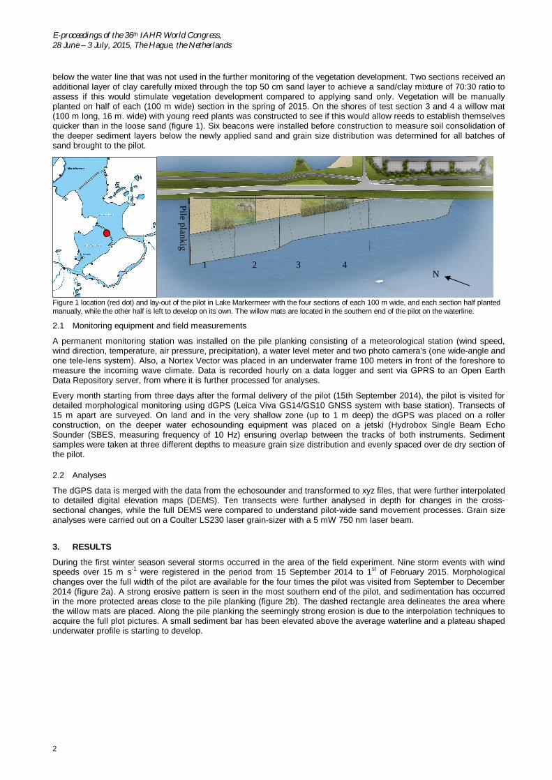
below the water line that was not used in the further monitoring of the vegetation development. Two sections received anadditional layer of clay carefully mixed through the top 50 cm sand layer to achieve a sand/clay mixture of 70:30 ratio toassess if this would stimulate vegetation development compared to applying sand only. Vegetation will be manuallyplanted on half of each (100 m wide) section in the spring of 2015. On the shores of test section 3 and 4 a willow mat(100 m long, 16 m. wide) with young reed plants was constructed to see if this would allow reeds to establish themselvesquicker than in the loose sand (figure 1). Six beacons were installed before construction to measure soil consolidation ofthe deeper sediment layers below the newly applied sand and grain size distribution was determined for all batches ofsand brought to the pilot.
Figure 1 location (red dot) and lay-out of the pilot in Lake Markermeer with the four sections of each 100 m wide, and each section half plantedmanually, while the other half is left to develop on its own. The willow mats are located in the southern end of the pilot on the waterline.
2.1 Monitoring equipment and field measurements
A permanent monitoring station was installed on the pile planking consisting of a meteorological station (wind speed,wind direction, temperature, air pressure, precipitation), a water level meter and two photo camera’s (one wide-angle andone tele-lens system). Also, a Nortex Vector was placed in an underwater frame 100 meters in front of the foreshore tomeasure the incoming wave climate. Data is recorded hourly on a data logger and sent via GPRS to an Open EarthData Repository server, from where it is further processed for analyses.
Every month starting from three days after the formal delivery of the pilot (15th September 2014), the pilot is visited fordetailed morphological monitoring using dGPS (Leica Viva GS14/GS10 GNSS system with base station). Transects of15 m apart are surveyed. On land and in the very shallow zone (up to 1 m deep) the dGPS was placed on a rollerconstruction, on the deeper water echosounding equipment was placed on a jetski (Hydrobox Single Beam EchoSounder (SBES, measuring frequency of 10 Hz) ensuring overlap between the tracks of both instruments. Sedimentsamples were taken at three different depths to measure grain size distribution and evenly spaced over de dry section ofthe pilot.
2.2 Analyses
The dGPS data is merged with the data from the echosounder and transformed to xyz files, that were further interpolatedto detailed digital elevation maps (DEMS). Ten transects were further analysed in depth for changes in the cross-sectional changes, while the full DEMS were compared to understand pilot-wide sand movement processes. Grain sizeanalyses were carried out on a Coulter LS230 laser grain-sizer with a 5 mW 750 nm laser beam.
3. RESULTS
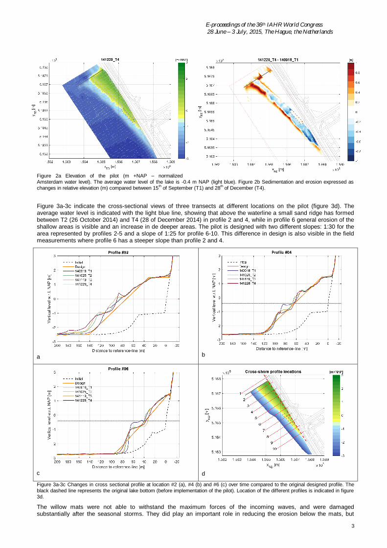
During the first winter season several storms occurred in the area of the field experiment. Nine storm events with windspeeds over 15 m s-1 were registered in the period from 15 September 2014 to 1st of February 2015. Morphologicalchanges over the full width of the pilot are available for the four times the pilot was visited from September to December2014 (figure 2a). A strong erosive pattern is seen in the most southern end of the pilot, and sedimentation has occurredin the more protected areas close to the pile planking (figure 2b). The dashed rectangle area delineates the area wherethe willow mats are placed. Along the pile planking the seemingly strong erosion is due to the interpolation techniques toacquire the full plot pictures. A small sediment bar has been elevated above the average waterline and a plateau shapedunderwater profile is starting to develop.
N1 2 3 4
Pileplankig
E-proceedings of the 36th IAHR World Congress 28 June – 3 July, 2015, The Hague, the Netherlands
3
Figure 2a Elevation of the pilot (m +NAP – normalizedAmsterdam water level). The average water level of the lake is -0.4 m NAP (light blue). Figure 2b Sedimentation and erosion expressed aschanges in relative elevation (m) compared between 15th of September (T1) and 28th of December (T4).
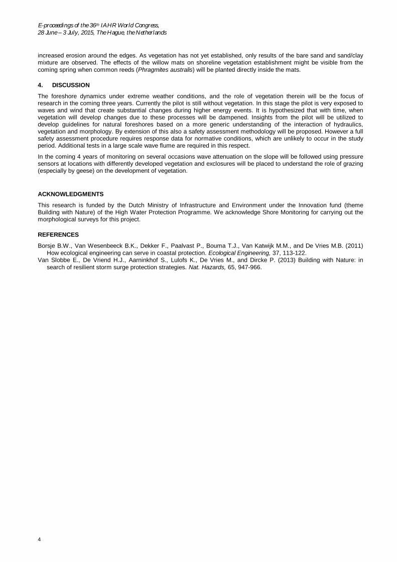
Figure 3a-3c indicate the cross-sectional views of three transects at different locations on the pilot (figure 3d). Theaverage water level is indicated with the light blue line, showing that above the waterline a small sand ridge has formedbetween T2 (26 October 2014) and T4 (28 of December 2014) in profile 2 and 4, while in profile 6 general erosion of theshallow areas is visible and an increase in de deeper areas. The pilot is designed with two different slopes: 1:30 for thearea represented by profiles 2-5 and a slope of 1:25 for profile 6-10. This difference in design is also visible in the fieldmeasurements where profile 6 has a steeper slope than profile 2 and 4.
a b
c d
Figure 3a-3c Changes in cross sectional profile at location #2 (a), #4 (b) and #6 (c) over time compared to the original designed profile. Theblack dashed line represents the original lake bottom (before implementation of the pilot). Location of the different profiles is indicated in figure3d.
The willow mats were not able to withstand the maximum forces of the incoming waves, and were damagedsubstantially after the seasonal storms. They did play an important role in reducing the erosion below the mats, but
E-proceedings of the 36th IAHR World Congress,28 June – 3 July, 2015, The Hague, the Netherlands
4
increased erosion around the edges. As vegetation has not yet established, only results of the bare sand and sand/claymixture are observed. The effects of the willow mats on shoreline vegetation establishment might be visible from thecoming spring when common reeds (Phragmites australis) will be planted directly inside the mats.
4. DISCUSSION
The foreshore dynamics under extreme weather conditions, and the role of vegetation therein will be the focus ofresearch in the coming three years. Currently the pilot is still without vegetation. In this stage the pilot is very exposed towaves and wind that create substantial changes during higher energy events. It is hypothesized that with time, whenvegetation will develop changes due to these processes will be dampened. Insights from the pilot will be utilized todevelop guidelines for natural foreshores based on a more generic understanding of the interaction of hydraulics,vegetation and morphology. By extension of this also a safety assessment methodology will be proposed. However a fullsafety assessment procedure requires response data for normative conditions, which are unlikely to occur in the studyperiod. Additional tests in a large scale wave flume are required in this respect.
In the coming 4 years of monitoring on several occasions wave attenuation on the slope will be followed using pressuresensors at locations with differently developed vegetation and exclosures will be placed to understand the role of grazing(especially by geese) on the development of vegetation.
ACKNOWLEDGMENTS
This research is funded by the Dutch Ministry of Infrastructure and Environment under the Innovation fund (themeBuilding with Nature) of the High Water Protection Programme. We acknowledge Shore Monitoring for carrying out themorphological surveys for this project.
REFERENCES
Borsje B.W., Van Wesenbeeck B.K., Dekker F., Paalvast P., Bouma T.J., Van Katwijk M.M., and De Vries M.B. (2011)How ecological engineering can serve in coastal protection. Ecological Engineering, 37, 113-122.
Van Slobbe E., De Vriend H.J., Aarninkhof S., Lulofs K., De Vries M., and Dircke P. (2013) Building with Nature: insearch of resilient storm surge protection strategies. Nat. Hazards, 65, 947-966.