Embed Size (px)
Citation preview
STAATSKOERANT, 14 S EPTEMBER 2012 No.35667 61
NOTICE 741 OF 2012
DEPARTMENT WATER AFFAIRS
INVITATION TO SUBMIT WRITTEN COMMENTS IN TERMS OF SECTION 110 OF THE NATIONAL WATER ACT 1998 (ACT 36 OF 1998) ON THE PROPOSED RAISING OF THE CLANWILLIAM DAM AND THE ENVIRONMENTAL IMPACT ASSESMENT RELATING THERETO
The Minister of Water and Environmental Affairs intends constructing a government waterworks as contained in the Schedule hereto.
In terms of Section 110(1)(b)(iii) of the National Water Act, 1998 (Act 36 of 1998), interested parties are invited to submit written comments on the proposed waterworks and the environmental impact assessment by 30 November 2012. Comments must be submitted to the Director-General, Department of Water Affairs, Private Bag X313, Pretoria; Fax: 012 336 7399 and marked for attention of Mr. M Mugumo, Chief Engineer Options Analysis (South).
SCHEDULE TO THE PROPOSED RAISING OF THE CLANWILLIAM DAM AS A GOVERNMENT WATERWORKS AND A SUMMARY OF THE ENVIROMENTAL IMPACT ASSESSEMENT
A. PROPOSED CONSTRUCTION OF THE SCHEME
PURPOSE
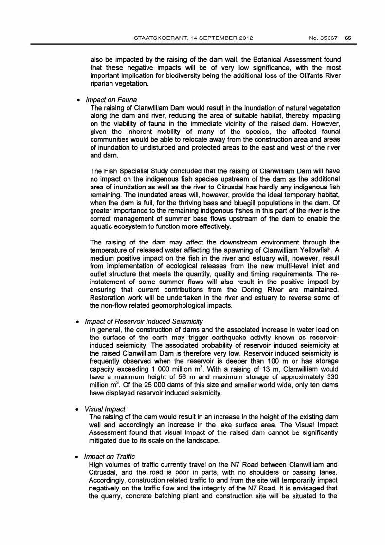
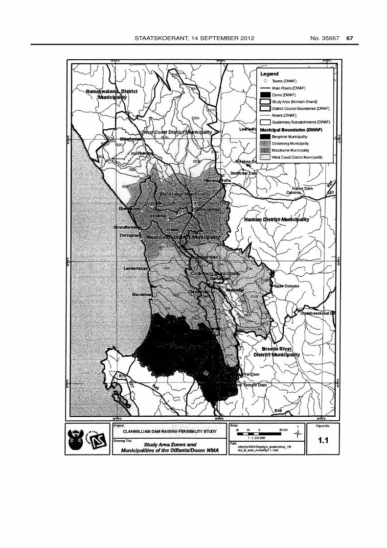
Clanwilliam Dam has been exposed to a chemical reaction in the concrete that may affect the integrity of the structure in the medium to long term. The main threat is inherent to dams equipped with crest gates. Failure to operate these gates under extreme flood conditions may result in overtopping of the non-overspill crest, which has the potential to result in damage. The latter will be addressed during rehabilitation works to improve the shear resistance of the foundations of the dam. The opportunity will also be taken to raise the dam, in conjunction with the dam safety work, to create additional yield. The objective of the project will be (a) to establish resource poor farmers in sustainable farming enterprises, (b) to reduce poverty, improve livelihoods and provide job opportunities, and (c) to improve the assurance of supply to existing commercial farmers on the scheme. The allocation of the additional yield will be guided by the Water Allocation Reform Strategy and the Broad Based Black Economic Empowerment Act (Act No. 53 of 2003). A locality map of the scheme is attached.
RAISING OF CLANWILLIAM DAM
Clanwilliam Dam is situa~e.d on the Olifants River near the town of Clanwilliam which is within the Cederberg Municipality in the Western Cape Province. The dam was originally built in 1935 and was later raised by 6 metres to its current level in 1969 to provide for an increasing irrigation demand. In recent years, the Lower Olifants River Water Users Association requested the Department of Water Affairs to investigate the feasibility of raising the dam in conjunction with the rehabilitation of the dam wall. Raising of the full supply level would increase the storage capacity and yield of the dam and improve water availability, which is currently considered inadequate for the
62 No. 35667 GOVERNMENT GAZETTE, 14 SEPTEMBER 2012
high value crops produced on the scheme. A feasibility study was subsequently undertaken to consider all the implications of raising the dam.
The feasibility study, completed in October 2007, found that raising the dam was both technically feasible and financially viable and recommended that the dam be raised by 13 metres. The project involves extending the dam wall on the downstream side and then raising it to a higher level. The additional yield for a 13 m raising, allowing for current water allocation, upstream use and ecological water requirements, was assessed as 69.5 million m3 per annum. This additional yield will provide an opportunity to establish resource poor farmers to promote food security and decent employment through inclusive economic growth.
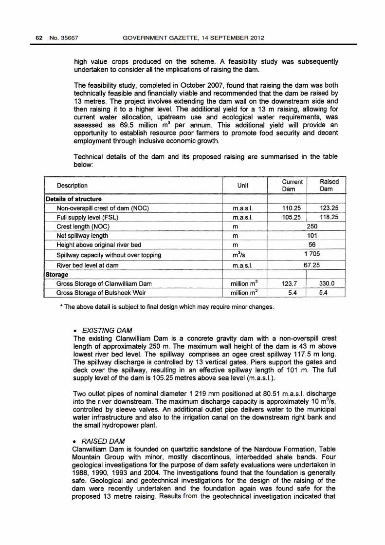
Technical details of the dam and its proposed raising are summarised in the table below:
Description Unit Current Raised Dam Dam
Details of structure Non-overspill crest of dam (NOC) m.a.s.l. 110.25 123.25 Full supply level (FSL) m.a.s.l. 105.25 118.25 Crest length (NOC) m 250 Net spillway length m 101 Height above original river bed m 56
Spillway capacity without over topping m3/s 1 705
River bed level at dam m.a.s.l. 67.25 Storage
Gross Storage of Clanwilliam Dam million m3 123.7 330.0 Gross Storage of Bulshoek Weir million m3 5.4 5.4
*The above detail is subject to final design which may require minor changes.
• EXISTING DAM The existing Clanwilliam Dam is a concrete gravity dam with a non-overspill crest length of approximately 250 m. The maximum wall height of the dam is 43 m above lowest river bed level. The spillway comprises an ogee crest spillway 117.5 m long. The spillway discharge is controlled by 13 vertical gates. Piers support the gates and deck over the spillway, resulting in an effective spillway length of 101 m. The full supply level of the dam is 105.25 metres above sea level (m.a.s.l.).
Two outlet pipes of nominal diameter 1 219 mm positioned at 80.51 m.a.s.l. discharge into the river downstream. The maximum discharge capacity is approximately 1 0 m3/s, controlled by sleeve valves. An additional outlet pipe delivers water to the municipal water infrastructure and also to the irrigation canal on the downstream right bank and the small hydropower plant.
• RAISEDDAM Clanwilliam Dam is founded on quartzitic sandstone of the Nardouw Formation, Table Mountain Group with minor, mostly discontinous, interbedded shale bands. Four geological investigations for the purpose of dam safety evaluations were undertaken in 1988, 1990, 1993 and 2004. The investigations found that the foundation is generally safe. Geological and geotechnical investigations for the design of the raising of the dam were recently undertaken and the foundation again was found safe for the proposed 13 metre raising. Results f rom the geotechnical investigation indicated that
STAATSKOERANT, 14 SEPTEMBER 2012 No. 35667 63
adequate aggregate is available for the proposed raising by roller compacted concrete (RCC). RCC is the preferred material mainly due to the rapid tempo at which it can be placed, resulting in shortened construction periods and its relatively low heat of hydration. The design of the raising of the dam was therefore based on the use of RCC.
Raising of Clanwilliam Dam will be designed to pass the 1:200 year flood of 1 990 m3/s which was adopted as the recommended design flood (RDF). The safety evaluation flood (SEF) is estimated to be 4 500 m3/s. No flood gates or other mechanical or electrical equipment will be installed to operate the spillway of the raised dam. Such equipment was avoided as it can reduce the discharge capacity of the spillway when malfunctioning. A standard uncontrolled ogee spillway will be designed for the raised dam.
B. SUMMARY OF THE ENVIRONMENTAL IMPACT ASSESMENT (EIA) (For more information please see full EIA on the website http://www.dwaf.gov.za/Documents/WMA/17)
An environmental impact assessment (EIA) was undertaken in parallel with the Feasibility Study for Raising Clanwilliam Dam and completed in September 2007. Environmental authorization was subsequently granted in February 2010 in a Record of Decision effective over a five year period. The findings of the EIA study are summarized below.
• Socio-Economic Poverty levels are extremely high throughout the Olifants/Doring catchment, with more than 70% of households living on less than R38 500 per annum in all areas. Direct dependence on aquatic ecosystem resources is negligible except in the case of the estuary where up to 200 households in the Ebenhaeser community are involved in a gill net fishery. The Reserve Determination study however found that with the raising of Clanwilliam Dam, an Ecological Reserve Category of B (largely natural with few modifications) can be achieved and maintained at the estuary. The negative impact on estuarine livelihoods would be very low.
Agriculture is the dominant economic activity in the area which means access to water for irrigation could greatly improve livelihoods for the poor households in the catchment. The raising of Clanwilliam Dam will improve the assurance of supply to protect agricultural investment in the catchment from severe climatic conditions. Much of the additional yield created by the raising of the dam will be allocated to resource poor farmers to be established in the area, resulting in improved job creation and livelihoods. The socio-economic impact assessment found that while only 650 construction jobs, approximately, will be created, as many as 3 000 new jobs could ultimately be created and R200 million in additional gross geographic product generated as a result of raising the dam.
• Ecological Reserve The Reserve Determination study found that in terms of hydrology, the Olifants River is naturally perennial, with distinctly seasonal flow with a high flow period in winter, low flow period in summer and intermediate flow periods in spring and autumn. The present ecological status (PES) of the Olifants River upstream of the Clanwilliam Dam and downstream of the confluence with the Hex River can be classified as largely modified and was classified as Category D. The PES of the Olifants River downstream of Clanwilliam Dam and Bulshoek Weir can be classified as seriously modified, with extensive loss of natural in-stream habitat and the system being extremely unstable. This section of the river was classified
64 No. 35667 GOVERNMENT GAZETTE, 14 SEPTEMBER 2012
as Category E. The Olifants Estuary is considered to be extremely important from an ecological and social perspective, and has been targeted as a Desired Protected Area. The study found that the PES of the estuary can be classified as moderately modified or Category C. The Reserve study recommended that further water resource development should be limited only to the Olifants River and that the Doring River should be preserved in its present, almost pristine condition.
• Impact on Groundwater Resources Based on historical evidence, there is concern that raising Clanwilliam Dam could result in raising the groundwater table, resulting in increased spring flow in the town, the development of new springs or seep areas. These could result in, inter alia, increased rising damp problems for some of the residents in Clanwilliam. A geohydrological investigation was therefore undertaken to investigate the potential impact on geohydrology of the area. The investigation found that the impact is of medium negative significance. Extensive groundwater monitoring, through monitoring wells, tracer testing in the vicinity of springs and seeps to measure groundwater flow and transport parameters will be undertaken to determine whether raising the dam will affect the groundwater table. If this is proven, appropriate mitigation measures will be designed.
• Impact on Heritage Resources Clanwilliam Dam is located in an area with numerous sites containing rock art, Stone Age tool deposits and other culturally significant artefacts. The raising of the dam could result in the inundation of significant artefacts and rock paintings from the Early, Middle and Later Stone Ages as well as historical structures and graves. Out of the 26 rock art sites identified by the Heritage Impact Assessment, the significance of inundation of the majority of these sites was found to be very low to medium. The implementation of mitigation measures specified in the Record of Decision will be further investigated to reduce impacts on archaeological and heritage material.
• Impact of Inundation on Infrastructure The raising of the dam wall will inundate various roads in the study area such as the national N7 Road, portions of the gravel road between Clanwilliam and Citrusdal, portions of the road to Algeria from Route N7, portions of the Citrusdal Road (MR 539) and portions of the Renbaan Road (MR 16/2). The affected road portions will be re-aligned and/or raised to restore access and ensure at least the current level of service.
There is a suite of developments that surround the Clanwilliam dam, ranging from commercial farms to residential properties and tourism facilities. The inundation of such infrastructure will result in a range of impacts including loss of income and viability of farms in some cases. An independent Valuator will determine fair compensation, based on market value, for affected properties within the dam basin in accordance with legislation.
• Impact on Flora The vegetation of the Olifants River catchment is characterized by two main vegetation types, namely the Fynbos and Succulent Karoo, while the area in the vicinity of the dam basin is characterized by Fynbos. The Botanical Assessment found that whilst the Citrusdai-Cianwilliam Valley is in the Greater Cederberg Biosphere Reserve Corridor, the study area is not considered to be a floristic hotspot. This is largely due to the fact that large parts of the area around the dam basin are cultivated and disturbed due to agricultural activities. Fluctuations in water levels in the existing dam have already transformed much of the vegetation up to the Full Supply Level. While some listed Red Data Book plant species will
STAATSKOERANT, 14 SEPTEMBER 2012 No. 35667 65
also be impacted by the raising of the dam wall, the Botanical Assessment found that these negative impacts will be of very low significance, with the most important implication for biodiversity being the additional loss of the Olifants River riparian vegetation.
• Impact on Fauna The raising of Clanwilliam Dam would result in the inundation of natural vegetation along the dam and river, reducing the area of suitable habitat, thereby impacting on the viability of fauna in the immediate vicinity of the raised dam. However, given the inherent mobility of many of the species, the affected faunal communities would be able to relocate away from the construction area and areas of inundation to undisturbed and protected areas to the east and west of the river and dam.
The Fish Specialist Study concluded that the raising of Clanwilliam Dam will have no impact on the indigenous fish species upstream of the dam as the additional area of inundation as well as the river to Citrusdal has hardly any indigenous fish remaining. The inundated areas will, however, provide the ideal temporary habitat, when the dam is full, for the thriving bass and bluegill populations in the dam. Of greater importance to the remaining indigenous fishes in this part of the river is the correct management of summer base flows upstream of the dam to enable the aquatic ecosystem to function more effectively.
The raising of the dam may affect the downstream environment through the temperature of released water affecting the spawning of Clanwilliam Yellowfish. A medium positive impact on the fish in the river and estuary will, however, result from implementation of ecological releases from the new multi-level inlet and outlet structure that meets the quantity, quality and timing requirements. The reinstatement of some summer flows will also result in the positive impact by ensuring that current contributions from the Doring River are maintained. Restoration work will be undertaken in the river and estuary to reverse some of the non-flow related geomorphological impacts.
• Impact of Reservoir Induced Seismicity In general, the construction of dams and the associated increase in water load on the surface of the earth may trigger earthquake activity known as reservoirinduced seismicity. The associated probability of reservoir induced seismicity at the raised Clanwilliam Dam is therefore very low. Reservoir induced seismicity is frequently observed when the reservoir is deeper than 1 00 m or has storage capacity exceeding 1 000 million m3 . With a raising of 13 m, Clanwilliam would have a maximum height of 56 m and maximum storage of approximately 330 million m3. Of the 25 000 dams of this size and smaller world wide, only ten dams have displayed reservoir induced seismicity.
• Visuallmpact The raising of the dam would result in an increase in the height of the existing dam wall and accordingly an increase in the lake surface area. The Visual Impact Assessment found that visual impact of the raised dam cannot be significantly mitigated due to its scale on the landscape.
• Impact on Traffic High volumes of traffic currently travel on the N7 Road between Clanwilliam and Citrusdal, and the road is poor in parts, with no shoulders or passing lanes. Accordingly, construction related traffic to and from the site will temporarily impact negatively on the traffic flow and the integrity of the N7 Road. It is envisaged that the quarry, concrete batching plant and construction site will be situated to the
66 No. 35667 GOVERNMENT GAZETTE, 14 SEPTEMBER 2012
west of the N7 Road. Access will be provided under the re-aligned N7 Road to facilitate traffic between the construction site and the dam wall to minimize the potential safety risk and traffic impacts.
• Sourcing of Construction Materials A range of materials will be required for the raising of the dam wall, including different grades of aggregate for production of concrete. The majority of the material will be sourced from the extension of the existing quarry and as far as possible from the dam basin itself. Any additional material required may be competitively sourced from a commercial supplier.
• Public Participation Extensive public participation was undertaken during the Feasibility Study and especially during the Environmental Impact Assessment. Interested and Affected Parties were extensively involved to obtain their views about the dam raising and associated impacts. The procedure to be followed for payment of compensation for affected properties was presented to the Interested and Affected Parties. An appeal process was followed before the environmental authorization was issued by the Department of Environmental Affairs.
• Environmental Management Plan (EMP) A detailed EMP will be developed to guide the various activities associated with construction and operation phases of the raised dam. The plan will include details of monitoring requirements and be submitted to Department of Environmental Affairs for approval.
LUv\i~~q DIRECTOR-GENERAL Department of Water Affairs
Date: 3 { { cr( / C G }L
STAATSKOERANT, 14 SEPTEMBER 2012 No. 35667 67
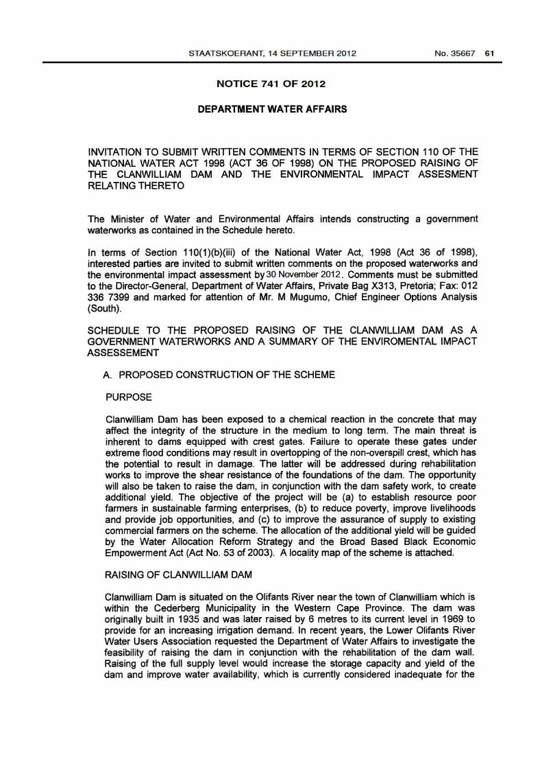
-~~ Prtject . .-. . . .
CLANWILLiAM DAM RAISIIIIG'FEA~III31LI1Y sn.DY
D'awing lltie: Study Area Zones and
Municipalities of the 01/lants/Doorn WMA
0 Towns (DWIF)
-- Main Roads (DWIF) -Dams (!JNAF)
c:J Study Area (Ninham Shand)
c:J DSITict Coundl Boundaries (OWAF)
-- Rivers (DWIF)
Municipal Boundaries (DWAFI
- BeryrivierMunidpality
Ill! Cederberg Municipality
~ Matzikama Munidpality
j::, - :IIM!st Coast District Municipality
Scale:
20•--==1:i!..::::i••••20 Km
Paltt
1:1300000 tlhydro/(00415/glslgls_projectslrep_161 rep_st_area_zoneslflg1.1.n'Kd
1.1