Embed Size (px)
Citation preview

National Road 3: De Beers Pass Section Draft Environmental Impact Assessment Report December 2014
Cave Klapwijk and Associates 3-1
3-1 3-1
NATIONAL ROAD 3: KEEVERSFONTEIN TO WARDEN (DE BEERS PASS SECTION)
CHAPTER 3: DESCRIPTION OF THE PROJECT
3. DESCRIPTION OF THE PROJECT
This Chapter presents a description of the De Beers Pass Route (DBPR) for which SANRAL is applying for authorisation, and is based on the Technical Review Report (Volume 2: Appendix Q).
The DBPR deviates from the existing N3 alignment on the farm Keeversfontein in KwaZulu-Natal, immediately north of the Tugela Toll Plaza, and ends at the Warden North interchange in the Free State where it re-joins the existing N3 to Gauteng. The DBPR deviates entirely from the existing N3 between Keeversfontein and Warden via Harrismith, taking a direct alignment across open country on land owned by SANRAL (Figure 3-1).
The entire DBPR is on a new alignment crossing predominately farmland. The land for the DBPR was acquired during 1998/99. When the DBPR is constructed, the existing R103 alignment between Keeversfontein and Warden via Harrismith will continue to perform the function of a National road, but with less traffic. This will provide an improved level of service to road users who have Harrismith as a destination, or those who have an inland destination via the N5.
3.1 DESCRIPTION OF THE DE BEERS PASS ROUTE
The 98 km route consists of three portions, each with unique characteristics (Figure
3-2), namely:
HS6: km 36 to km 59, approximately 23 km long: Keeversfontein to KwaZulu-Natal/Free State border (HS6);
HS7: km 0 to km 45, approximately 45 km long: KwaZulu-Natal/Free State Border to Meul River; and
HS8: km 0 to km 30 approximately 30 km long: Meul River to Warden North interchange.
Section HS6 starts at the Tugela Toll Plaza and climbs the escarpment up to the KwaZulu-Natal/Free State border. The landscape of the first portion of HS6 is fairly undulating for approximately 10 km, crossing the Ladysmith to Harrismith railway line and road D284 before crossing the Klip River, after which the route climbs up the escarpment to the highest point along the route at an elevation of approximately 1 650 m. The last 6 km of the climb follows a spur in the escarpment landform just to the north-east of the existing Ingula Access Road (S61). A 500 m long tunnel is required near the top of the ascent of the escarpment. After the tunnel, the route flattens out before reaching the KwaZulu-Natal/Free State border. The section is approximately 23 km long, and has an elevation gain of more than 590 m. The steepest gradient is 5 %.
Figure 3-3 depicts the road profile for HS6. The design is in accordance with the applicable design standards for a 120 km/h rural freeway.

National Road 3: De Beers Pass Section Draft Environmental Impact Assessment Report December 2014
Cave Klapwijk and Associates 3-2
3-2 3-2
Figure 3-1: De Beers Pass Route Sections

National Road 3: De Beers Pass Section Draft Environmental Impact Assessment Report December 2014 25 August 2014
Cave Klapwijk and Associates 3-3
3-3 3-3
Figure 3-2: DBPR showing Highway Sections

National Road 3: De Beers Pass Section Draft Environmental Impact Assessment Report December 2014
Cave Klapwijk and Associates 3-4
3-4 3-4
Figure 3-3: Profile of DBPR HS6
Section HS7 traverses the rolling hills of the Free State between the KwaZulu-Natal/Free State border and the Meul River. HS7 starts at the provincial border, and crosses the upper reaches of the Wilge River catchment before passing south of Tantjiesberg. The route continues north-west, crossing three tertiary roads (the S691, S799 and S692) before intersecting the R722 at the Lincoln Interchange and ends at the Meul River. The section is 45 km long. Figure 3-4 depicts the road profile for HS7.
Section HS6

National Road 3: De Beers Pass Section Draft Environmental Impact Assessment Report December 2014
Cave Klapwijk and Associates 3-5
3-5
Section H57
National Road 3: De Beers Pass Section Draft Environmental Impact Assessment Report December 2014
Cave Klapwijk and Associates 3-6
3-6
Figure 3-4: Profile DBPR HS7
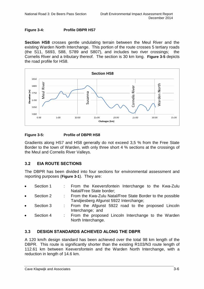
Section HS8 crosses gentle undulating terrain between the Meul River and the existing Warden North Interchange. This portion of the route crosses 5 tertiary roads (the S11, S693, S88, S789 and S807), and includes two river crossings; the Cornelis River and a tributary thereof. The section is 30 km long. Figure 3-5 depicts the road profile for HS8.
Figure 3-5: Profile of DBPR HS8
Gradients along HS7 and HS8 generally do not exceed 3,5 % from the Free State Border to the town of Warden, with only three short 4 % sections at the crossings of the Meul and Cornelis River Valleys.
3.2 EIA ROUTE SECTIONS
The DBPR has been divided into four sections for environmental assessment and reporting purposes (Figure 3-1). They are:
Section 1 : From the Keeversfontein Interchange to the Kwa-Zulu Natal/Free State border;
Section 2 : From the Kwa-Zulu Natal/Free State Border to the possible Tandjiesberg Afgunst 5922 Interchange;
Section 3 : From the Afgunst 5922 road to the proposed Lincoln Interchange; and
Section 4 : From the proposed Lincoln Interchange to the Warden North Interchange.
3.3 DESIGN STANDARDS ACHIEVED ALONG THE DBPR
A 120 km/h design standard has been achieved over the total 98 km length of the DBPR. This route is significantly shorter than the existing R103/N3 route length of 112.61 km between Keeversfontein and the Warden North Interchange, with a reduction in length of 14.6 km.
Section HS8
Section HS7

National Road 3: De Beers Pass Section Draft Environmental Impact Assessment Report December 2014
Cave Klapwijk and Associates 3-7
3-7
3.4 CROSS SECTION
The carriageway cross-sections on the DBPR conform to SANRAL standards. The southern portion of the route, HS6 (Section 1) falls within the boundaries of KwaZulu-Natal, and will be constructed as a 4 lane divided carriageway road, similar to the existing N3 to the south of the Tugela Toll Plaza. It consists of two traffic lanes in each direction with surfaced outer shoulders or emergency lanes. The two carriageways are separated by a grassed median (Figure 3-6).
Figure 3-6: Cross-section for DBPR Section 1
Once the route has crossed the KwaZulu-Natal/Free State Border, the dual-carriageway freeway changes to a 4 lane single carriageway roadway of freeway standard for Sections 2, 3 and 4 through to Warden where it connects with the existing four-lane single carriageway N3 freeway leading to the town of Villiers. The 4 lane undivided single carriageway cross-section consist of two traffic lanes in each direction with surfaced outer shoulders or emergency lanes. The two travel directions are separated by a painted median (Figure 3-7). The minimum 80 m wide road reserve is provided throughout.
Figure 3-7: Cross section of the DBPR Sections 2, 3 and 4
3.5 ACCESS TO THE DBPR
The DBPR is designed to be a limited access freeway as is the remainder of the N3 freeway between Durban and Johannesburg. Access to the freeway will be provided at grade separated interchanges.

National Road 3: De Beers Pass Section Draft Environmental Impact Assessment Report December 2014
Cave Klapwijk and Associates 3-8
3-8
The existing interchange at Keeversfontein will be modified to accommodate access from the R103 (Harrismith - Ladysmith). An interchange will be constructed at the farm Lincoln, which will give access to Road S18 (R722). At the Warden North interchange where the DBPR joins the existing N3, a north-bound diamond off-ramp and a south-bound diamond on-ramp will be provided. In addition, it is proposed that interchanges be provided at the new Ingula access road, at Road S922 on the farm Afgunst, at Road S692 on the farm Schreiners Claim, and at Road S788 on the farm Susanna. This will bring the total number of interchanges on this route to seven. Figure 3-1 depicts the locations of the interchanges and the possible additional interchanges.
3.6 TRAFFIC ACCOMMODATION DURING CONSTRUCTION
The majority of the DBPR is constructed across open land, with little interaction with existing trafficked roads. The construction of the DBPR will therefore have no impact on existing traffic, with the exception of isolated points where public roads intersect the DBPR. Where the route intersects district roads, the existing roads will be temporarily diverted during the construction of the over/underpasses that will accommodate them. Once the new structures have been completed, the roads will be connected to the new over/underpasses, and the diversions will be removed and land rehabilitated. This principle will also be followed where farm access roads are to be accommodated.
3.7 LEVEL OF SERVICE
The Level of Service (LOS) of any given road can be described as the relative efficiency of the vehicle stream, and can be measured in terms of speed, delay, freedom to manoeuvre, traffic interactions, comfort and convenience. LOS are calculated for current and future traffic using calibrated traffic models, to guide road designers in the design and timing of the upgrades. General definitions of degrees of LOS are as follows: A - Free flowing traffic; B - Reasonably free flowing traffic, C - Stable traffic flow; D - Approaching unstable traffic flow; E - Unstable traffic flow; F - Breakdown of traffic flow i.e. slow moving to stop-go operation.

National Road 3: De Beers Pass Section Draft Environmental Impact Assessment Report December 2014
Cave Klapwijk and Associates 3-9
3-9
Over time, the increase in traffic along a road gradually causes congestion and deteriorating LOS. When the LOS deteriorates to an unacceptable level, the road must be improved or an additional road must be built, to cater for the increased traffic, which will result in a better LOS. Typical interventions to improve road LOS include the addition of traffic lanes, improvements to intersection layouts, reduction in the number of intersections on a given length of road, and widening of traffic lanes to improve driver comfort and the construction of supplementary routes. By calculating the anticipated LOS in advance, road designers can assess the degree to which the road is suitable to carry the anticipated traffic, and the timing of any interventions can be determined and budgeted for. A LOS of C or better is preferable for national roads. A LOS of D is the minimum requirement of the N3. This is the accepted international standard for national road networks. Table 3-1 illustrates the calculated LOS over time, based on the predicted traffic along the 4-lane DBPR. It can be seen that, although LOS D is reached on approximately 11 km of the north-bound carriageway and approximately 6.5 km on the south-bound carriageway, the road will still function satisfactorily for the next 25 years.

National Road 3: De Beers Pass Section Draft Environmental Impact Assessment Report December 2014
Cave Klapwijk and Associates 3-10
3-10
Table 3-1: Levels of Service over time for the proposed DBPR
3.8 TUNNEL
Near the crest of the escarpment near the KwaZulu-Natal/Free State border, twin-tube tunnels accommodating three traffic lanes in each tube have been planned. The tunnels are about 535 m long. This length is approximate at this stage as the tunnel portal (entrance/exit) positions will only be finalised at the detail design stage. The tunnels are aligned in a south-east to north-west direction, with a curvature radius of about 1 500 m. The gradient is 5 % resulting in an elevation difference of approximately 28 m from end to end. The soffit height is about 11 m, and the width of the tunnel bores is about 14 m, and these are separated by about 14 m. Figure 3-8 illustrates the typical tunnel profile for a two lane carriageway, upgradable to three lanes in future. Lighting within the tunnels may be required, and this will consist of luminaries installed in a continuous band along the entire tunnel. As the tunnels are aligned in a south-east/north-west direction, vehicle drivers may experience visibility problems when leaving the tunnel portals with the sun at low levels in the mornings and evenings at certain times of the year. This is catered for by using counter-cast adaptive lighting at the tunnel portals.
3.9 TYPICAL CROSS-SECTIONS
The typical road carriageway, crossing road and interchange cross-sections that have been applied to the Dual Carriageway and Single Carriageway portions of all the route alternatives conform to SANRAL standards.

National Road 3: De Beers Pass Section Draft Environmental Impact Assessment Report December 2014
Cave Klapwijk and Associates 3-11
3-11 3-11
Figure 3-8: Typical cross section of the proposed tunnel (one of two bores shown)

National Road 3: De Beers Pass Section Draft Environmental Impact Assessment Report December 2014
Cave Klapwijk and Associates 3-12
3-12 3-12
The following figures illustrate the various road cross-sections applied to the Dual Carriageway and the Single Carriageway portions of the route alternatives as well as the crossing roads and interchange ramps:
Typical Cross Sections – Divided Dual Carriageway (Figure 3.9);
Typical Cross Sections – Undivided 4 Lane Carriageway (Figure 3.10);
Typical Cross Sections – Ramps, Single Lane (Figure 3.11);
Typical Cross Section – Single Carriageway, Provincial Main Roads (Figure 3.12);
Typical Cross Sections – Single Carriageway, District Roads (Figure 3.13); and
Typical Cross Sections – Gravel Access Roads: Cross Section and Basic Pavement Design (Figure 3.14).
3.10 QUARRIES, BOROW PITS AND ASPHALT PLANTS
The approval of quarries, borrow pits and asphalt plants sites will form the subject of separate applications.
3.10.1 Quarry and Crushing Plants
Crushed rock for road construction purposes will be obtained from commercial sources or from quarries identified by a geotechnical investigation. Should a quarry be established, it will require approval of a separate EMP.
3.10.2 Borrow Pits
Borrow pits for procuring gravel for road construction will be identified, and EMPs will be submitted for approval at the appropriate time.
3.10.3 Temporary Asphalt Plants
Asphalt Plants will require Atmospheric Emissions Licences. The locations of these temporary plants are not known at this stage.

National Road 3: De Beers Pass Section Draft Environmental Impact Assessment Report December 2014
Cave Klapwijk and Associates 3-13
3-13 3-13
Figure 3-9: Typical cross-sections No 1 (A0 reduced to A3) for report) – general (road with cuts and fills) (WSP)

National Road 3: De Beers Pass Section Draft Environmental Impact Assessment Report December 2014
Cave Klapwijk and Associates 3-14
3-14 3-14
Figure 3-10: Typical cross-section No 2 – general (road with cuts and fills (WSP)

National Road 3: De Beers Pass Section Draft Environmental Impact Assessment Report December 2014
Cave Klapwijk and Associates 3-15
3-15 3-15
Figure 3-11: Typical Cross Sections – Ramps, Single Lane
FIGURE 3.11

National Road 3: De Beers Pass Section Draft Environmental Impact Assessment Report December 2014
Cave Klapwijk and Associates 3-16
3-16
Figure 3-12: Typical Cross Sections – Single Carriageway, Provincial Main Roads
FIGURE 3.12

National Road 3: De Beers Pass Section Draft Environmental Impact Assessment Report December 2014
Cave Klapwijk and Associates 3-17
3-17
Figure 3-13: Typical Cross Sections – Single Carriageway, District Roads
FIGURE 3.13

National Road 3: De Beers Pass Section Draft Environmental Impact Assessment Report December 2014
Cave Klapwijk and Associates 3-18
3-18
Figure 3-14: Typical Cross Sections – Gravel Access Roads: Cross Section and Basic Pavement Design
FIGURE 3.14

National Road 3: De Beers Pass Section Draft Environmental Impact Assessment Report December 2014
Cave Klapwijk and Associates 3-19
3-19 3-19
3.10.4 Concrete Batching Plants
Concrete batching plants are used to mix concrete for use in concrete structures and for possible sections of concrete roadway.
3.11 SERVICE ROADS
Where local and provincial roads cross the DBPR alignment, provision will be made for over or under passes. Where previously agreed as part of the land acquisition negotiations, structures will be provided for farm roads severed by the DBPR alignment.
3.12 LAND ACQUISITION
A land audit report was compiled by the Manco-Aurecon Joint Venture (Volume 2: Appendix N). The land required for the DBPR was acquired during the 1990s. The road reserve for that original route was acquired by the Department of Transport and South African Roads Board with funding from the National Government, and this land now vests in SANRAL in terms of Section 7 of Act 7 of 1998. These properties are already registered in favour of SANRAL, which has the rights to all the properties affected by the DBPR.