Embed Size (px)
Citation preview
NHD Mapping/Editing Business Rules
1
National Hydrography Dataset (NHD) Updates and Improvements Mapping and Editing Business Rules
Last Update: 10/27/16
Table of Contents I. Overview . . . . . . . . . . . . . . . . . . . . . . . . . . . . . . . . . . . . . . . . . . . . . . . . . . . . . . . . . . . . . . . . . . . . . . . . . . . . . . . . 1 II. Reference Scales . . . . . . . . . . . . . . . . . . . . . . . . . . . . . . . . . . . . . . . . . . . . . . . . . . . . . . . . . . . . . . . . . . . . . . . . . 2 III. Editing Scale . . . . . . . . . . . . . . . . . . . . . . . . . . . . . . . . . . . . . . . . . . . . . . . . . . . . . . . . . . . . . . . . . . . . . . . . . . . . . 4 IV. Aerial Basemap and Collateral/Reference Datasets for NHD Editing . . . . . . . . . . . . . . . . . . . . . . . . . . . . . . . 4 V. Overview of Editing Tasks . . . . . . . . . . . . . . . . . . . . . . . . . . . . . . . . . . . . . . . . . . . . . . . . . . . . . . . . . . . . . . . . . . 5
VI. Editing Methods . . . . . . . . . . . . . . . . . . . . . . . . . . . . . . . . . . . . . . . . . . . . . . . . . . . . . . . . . . . . . . . . . . . . . . . . . . 9 VII. Quality Control (QC)/Quality Assurance (QA) . . . . . . . . . . . . . . . . . . . . . . . . . . . . . . . . . . . . . . . . . . . . . . . . . 10 VIII. Standard Mapping Business Rules . . . . . . . . . . . . . . . . . . . . . . . . . . . . . . . . . . . . . . . . . . . . . . . . . . . . . . . . . . 11
IX. Area-Specific Business Rules: Agriculturally-Dominated Areas . . . . . . . . . . . . . . . . . . . . . . . . . . . . . . . . . . . 20 X. Area-Specific Business Rules: Arid Regions . . . . . . . . . . . . . . . . . . . . . . . . . . . . . . . . . . . . . . . . . . . . . . . . . . . 25 XI. Area-Specific Business Rules: Urbanized/Semi-Urbanized Areas . . . . . . . . . . . . . . . . . . . . . . . . . . . . . . . . . 33
XII. Area-Specific Business Rules: Coastal Areas . . . . . . . . . . . . . . . . . . . . . . . . . . . . . . . . . . . . . . . . . . . . . . . . . . 34
I. Overview Improvement of high resolution (1:24,000) NHD, particularly the NHD features within the NHD Flowline, Waterbody, Area, Point, and Line feature classes is done through the USGS stewardship system and aims at making the NHD current by using various reference sources (primarily aerial imagery). The latest USGS NHD update and edit tools are used throughout the update process to manage NHD data and steer through the required workflow, which involves several phases to accomplish NHD updates. Each update effort sets an accuracy scale, typically at 1:24,000, reflective of the accuracy scale of the high-resolution NHD. Finer accuracy scales can be set where warranted and required to satisfy end-user requirements. Additionally, although not mandated, it is highly suggested to use the HUC12 as the minimum unit of editing when a full HUC8 will not be updated. This makes tracking more efficient and streamlined. In effort to standardize decision making throughout the update process, business rules for feature mapping and update assessment are used in conjunction with the standardized NHD-required workflow. Foundational business rules are often derived from the USGS’ NHD data dictionaries and feature-to-feature rules, which reinforce the NHD-standard data construct. If a rule is not listed in this document, the NHD documentation and rules are referred to and utilized by default. Often times, additional rules must be developed in order to aid and standardize decision making and set metrics for specific situations and hydrological features encountered through the update process. In many cases, these rules are tied to specific land cover types, which contain specific hydro features the rules apply to. The best approach to take when updating specific features in these cases may require research as well as input from and coordination with USGS and relevant stakeholders. When decisions are made on the best approach to take, definitions, standards, and rules are incorporated into this document and implemented in the current and future NHD update efforts. The ultimate goal is to document business rules for decision making so they are utilized and result a standardized hydro product. Moreover, this document is intended to be a “living” document and is meant to be updated and receive additions as new areas are mapped and new rules are developed. All editing and improvement work should be done in coordination with the State Steward, USGS, and any relevant project stakeholders.
NHD Mapping/Editing Business Rules
2
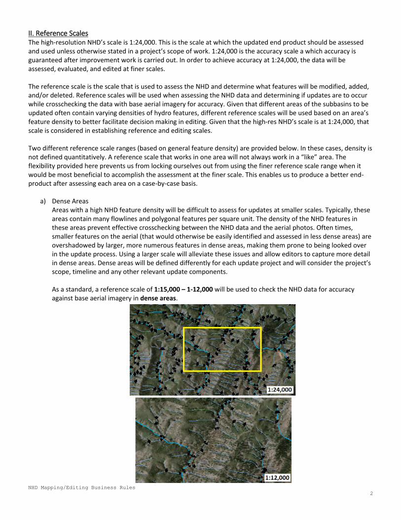
II. Reference Scales The high-resolution NHD’s scale is 1:24,000. This is the scale at which the updated end product should be assessed and used unless otherwise stated in a project’s scope of work. 1:24,000 is the accuracy scale a which accuracy is guaranteed after improvement work is carried out. In order to achieve accuracy at 1:24,000, the data will be assessed, evaluated, and edited at finer scales. The reference scale is the scale that is used to assess the NHD and determine what features will be modified, added, and/or deleted. Reference scales will be used when assessing the NHD data and determining if updates are to occur while crosschecking the data with base aerial imagery for accuracy. Given that different areas of the subbasins to be updated often contain varying densities of hydro features, different reference scales will be used based on an area’s feature density to better facilitate decision making in editing. Given that the high-res NHD’s scale is at 1:24,000, that scale is considered in establishing reference and editing scales. Two different reference scale ranges (based on general feature density) are provided below. In these cases, density is not defined quantitatively. A reference scale that works in one area will not always work in a “like” area. The flexibility provided here prevents us from locking ourselves out from using the finer reference scale range when it would be most beneficial to accomplish the assessment at the finer scale. This enables us to produce a better end-product after assessing each area on a case-by-case basis.
a) Dense Areas Areas with a high NHD feature density will be difficult to assess for updates at smaller scales. Typically, these areas contain many flowlines and polygonal features per square unit. The density of the NHD features in these areas prevent effective crosschecking between the NHD data and the aerial photos. Often times, smaller features on the aerial (that would otherwise be easily identified and assessed in less dense areas) are overshadowed by larger, more numerous features in dense areas, making them prone to being looked over in the update process. Using a larger scale will alleviate these issues and allow editors to capture more detail in dense areas. Dense areas will be defined differently for each update project and will consider the project’s scope, timeline and any other relevant update components. As a standard, a reference scale of 1:15,000 – 1-12,000 will be used to check the NHD data for accuracy against base aerial imagery in dense areas.
NHD Mapping/Editing Business Rules
3
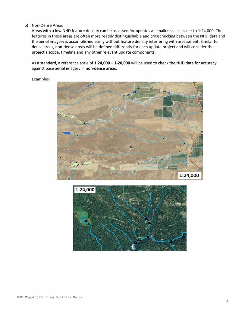
b) Non-Dense Areas
Areas with a low NHD feature density can be assessed for updates at smaller scales closer to 1:24,000. The features in these areas are often more readily distinguishable and crosschecking between the NHD data and the aerial imagery is accomplished easily without feature density interfering with assessment. Similar to dense areas, non-dense areas will be defined differently for each update project and will consider the project’s scope, timeline and any other relevant update components.
As a standard, a reference scale of 1:24,000 – 1-20,000 will be used to check the NHD data for accuracy against base aerial imagery in non-dense areas.
Examples:
NHD Mapping/Editing Business Rules
4
III. Editing Scale An editing scale is the scale at which the data is edited. A minimum mapping scale will ensure all data has been updated and edited at an established minimum scale. The editing scale is a finer scale than the reference scale of and thus, will ensure consistent accuracy at the accuracy scale. A scale of 1:12,000 – 1:10,000 will be used for any editing done to any NHD feature regardless of which reference scale was used. This scale range will also be referred to as the digitizing scale. It is important to note that using a larger scale (when compared to the reference scale) to carry out edits guarantees accuracy of the data at the reference scale. The completed product should be assessed for accuracy at the reference scale and not the editing scale as the reference scale serves as the scale of guaranteed accuracy.
IV. Aerial Basemaps and Collateral/Reference Datasets for NHD Editing and Decision Making a) NAIP Imagery
The latest NAIP aerial imagery sources a will be the primary datasets used to update the NHD data. They will be used to assess the NHD for updates and used when digitizing new NHD geometry or reshaping/modifying/updating existing NHD geometry. Whenever these datasets are not reliable, supporting and secondary sources will be utilized. Primary Aerial Sources Include: i. USFS Reg3 Resource 1-Meter Aerial Photos ii. Most Recent NAIP
b) Supporting Collateral Datasets for Update Assessment Additional collateral datasets will be used when the 2014 NAIP is not sufficient in determining appropriate editing decisions. These sources will aid decision making in NHD updates. The following sources will be used and their order reflects priority of use from top to bottom (i.e. NAIP 2012 will take precedence over ESRI Aerial Basemap in decision making).
i. Older Versions of the NAIP Imagery: Accessed via USDA/DFG online map service and other online services.
ii. NAIP CIR Imagery: Accessed via DFG online map service and other online services. iii. Google and/or BING Maps: Accessed via the Bing and Google Maps 3.0 add-in button. iv. Google Earth: Accessed via Google Earth software. v. ESRI Aerial Basemap: Accessed via ESRI basemap service. vi. ESRI US Topo Maps: Accessed via ESRI basemap service. vii. National Wetlands Inventory Dataset: Will be provided as-needed for each region that is
receiving updates. Will be used to help in decision-making regarding NHD swamp/marsh and other related features.
c) Region/Project Specific Reference Datasets
In each NHD update project, other hydro datasets will be assessed for usefulness and used for reference when helpful. These data sources can include local and regional data or other datasets from varying relevant agencies.
i. Riparian Map Data ii. Springs Stewardship Point Data iii. Stream Data with Names iv. Steve Rascona (AZ DWR) Hydro Data v. Other Datasets Obtained from Local Forests (Region 3)
*For more detail regarding project-specific datasets, see associated project reference dataset catalog.
NHD Mapping/Editing Business Rules
5
V. Overview of Editing Tasks NHD editing will require editors to assess the NHD data for updates by cross checking it with the most recent NAIP so that NHD features are made current. Frequency and types of editing tasks will vary from area to area. Below are some common editing tasks expected to be carried out and rules associated with them:
a) Feature Additions: When a feature on the base aerial is not represented in the NHD and is visible on the base aerial at the reference scale, it is to be added to the NHD data. Restrictions on the types of features and the number of features that will be added can apply (see area-specific business rules sections below).
b) Feature Updates: When a feature is present in the NHD data and in the base aerial, but its geometry, spatial location, and/or attributes do not reflect what is depicted on the base aerial at the reference scale, the feature will be updated to reflect the aerial. Updates may include:
i) Modify feature ii) Modify attributes iii) Replace geometry iv) Reshape feature v) Split feature vi) Mask geometry
c) Feature Deletions:
When a feature in the NHD data is not present on the base aerial, the largest possible reference scale will be used to confirm absence of feature on the base aerial. Additional collateral datasets will be used to assess absence of feature and the following will be considered:
i) Seasonality ii) Influence and presence of related features iii) Terrain iv) Change in landscape/landuse v) Other associated factors
If there is strong evidence, after review, to suggest the feature in the NHD is clearly an error, it will be deleted. Note: Editors will be conservative in feature deletions. If there is any doubt the NHD feature may be a true feature and not a clear erroneous feature, it will be kept in the data. A comment will also be placed in the subbasin’s Comment FC to track these cases.
NHD Mapping/Editing Business Rules
6
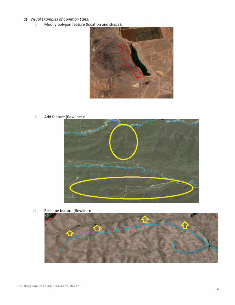
d) Visual Examples of Common Edits: i. Modify polygon feature (location and shape):
ii. Add feature (flowlines):
iii. Reshape feature (flowline):
NHD Mapping/Editing Business Rules
7
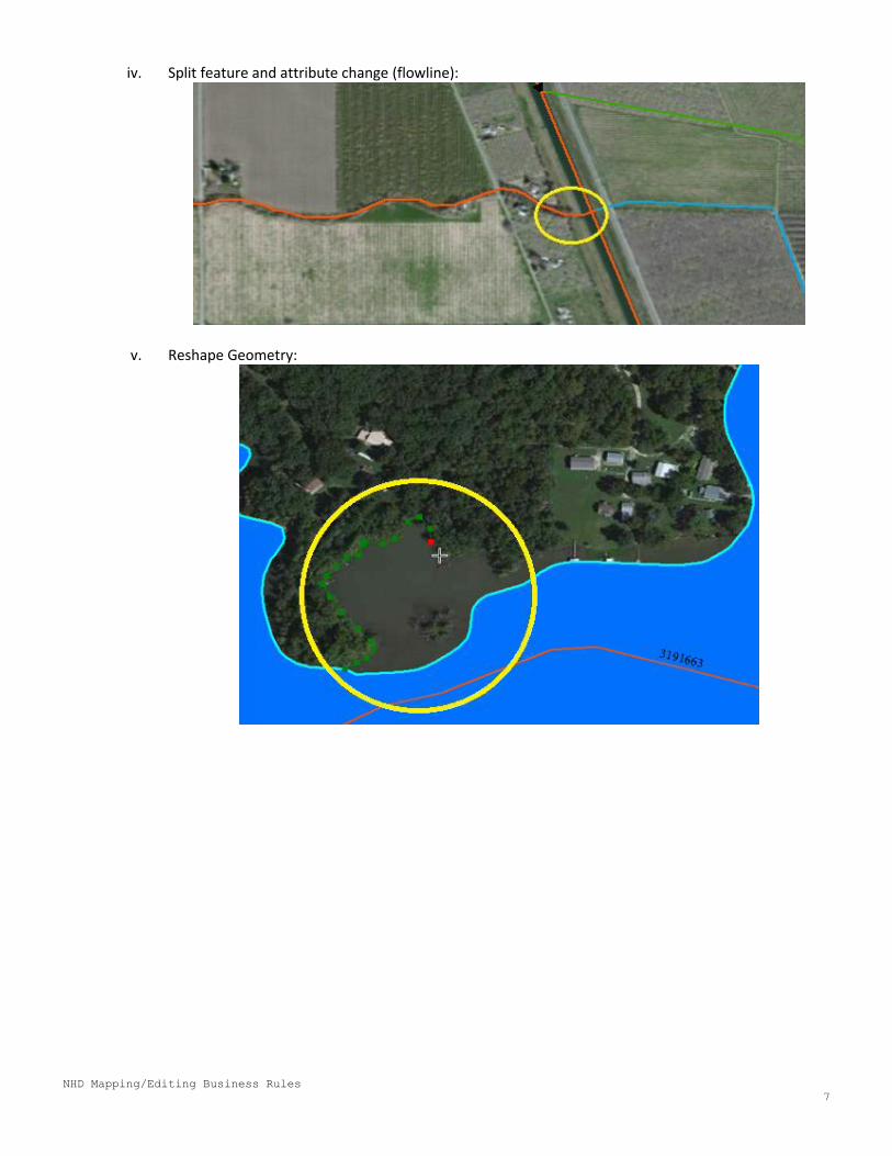
iv. Split feature and attribute change (flowline):
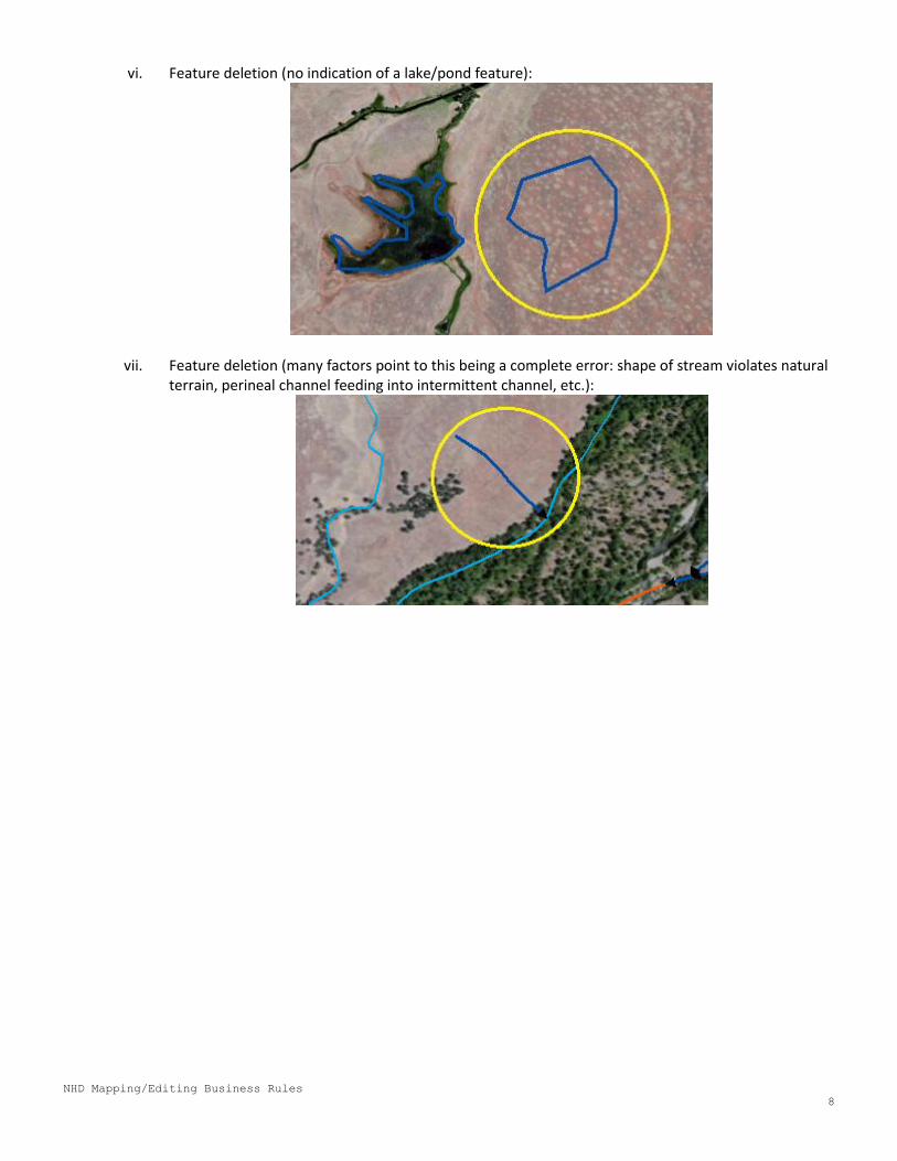
v. Reshape Geometry:
NHD Mapping/Editing Business Rules
8
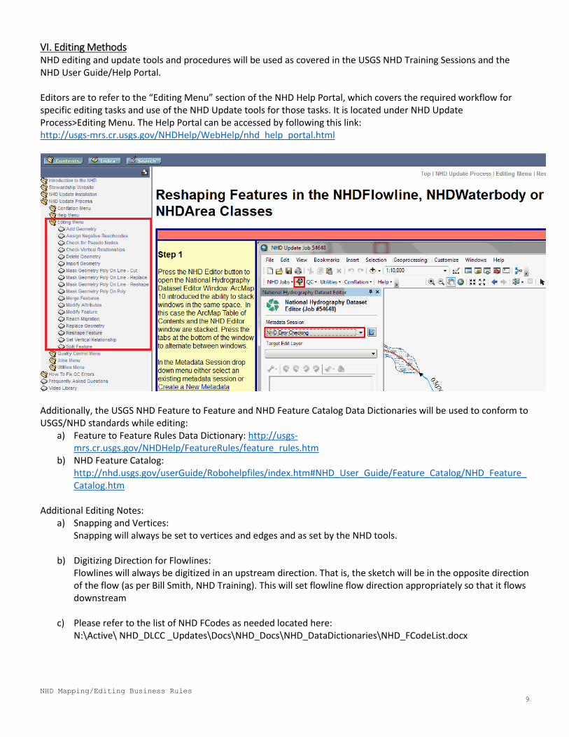
vi. Feature deletion (no indication of a lake/pond feature):
vii. Feature deletion (many factors point to this being a complete error: shape of stream violates natural terrain, perineal channel feeding into intermittent channel, etc.):
NHD Mapping/Editing Business Rules
9
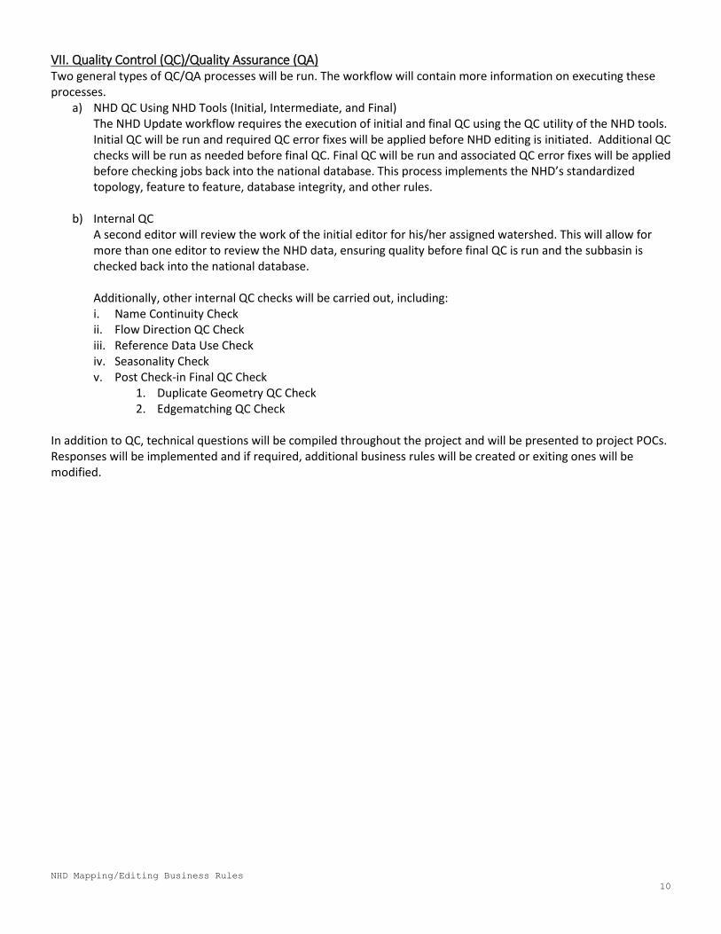
VI. Editing Methods NHD editing and update tools and procedures will be used as covered in the USGS NHD Training Sessions and the NHD User Guide/Help Portal. Editors are to refer to the “Editing Menu” section of the NHD Help Portal, which covers the required workflow for specific editing tasks and use of the NHD Update tools for those tasks. It is located under NHD Update Process>Editing Menu. The Help Portal can be accessed by following this link: http://usgs-mrs.cr.usgs.gov/NHDHelp/WebHelp/nhd_help_portal.html
Additionally, the USGS NHD Feature to Feature and NHD Feature Catalog Data Dictionaries will be used to conform to USGS/NHD standards while editing:
a) Feature to Feature Rules Data Dictionary: http://usgs-mrs.cr.usgs.gov/NHDHelp/FeatureRules/feature_rules.htm
b) NHD Feature Catalog: http://nhd.usgs.gov/userGuide/Robohelpfiles/index.htm#NHD_User_Guide/Feature_Catalog/NHD_Feature_Catalog.htm
Additional Editing Notes:
a) Snapping and Vertices: Snapping will always be set to vertices and edges and as set by the NHD tools.
b) Digitizing Direction for Flowlines: Flowlines will always be digitized in an upstream direction. That is, the sketch will be in the opposite direction of the flow (as per Bill Smith, NHD Training). This will set flowline flow direction appropriately so that it flows downstream
c) Please refer to the list of NHD FCodes as needed located here: N:\Active\ NHD_DLCC _Updates\Docs\NHD_Docs\NHD_DataDictionaries\NHD_FCodeList.docx
NHD Mapping/Editing Business Rules
10
VII. Quality Control (QC)/Quality Assurance (QA) Two general types of QC/QA processes will be run. The workflow will contain more information on executing these processes.
a) NHD QC Using NHD Tools (Initial, Intermediate, and Final) The NHD Update workflow requires the execution of initial and final QC using the QC utility of the NHD tools. Initial QC will be run and required QC error fixes will be applied before NHD editing is initiated. Additional QC checks will be run as needed before final QC. Final QC will be run and associated QC error fixes will be applied before checking jobs back into the national database. This process implements the NHD’s standardized topology, feature to feature, database integrity, and other rules.
b) Internal QC
A second editor will review the work of the initial editor for his/her assigned watershed. This will allow for more than one editor to review the NHD data, ensuring quality before final QC is run and the subbasin is checked back into the national database. Additionally, other internal QC checks will be carried out, including: i. Name Continuity Check ii. Flow Direction QC Check iii. Reference Data Use Check iv. Seasonality Check v. Post Check-in Final QC Check
1. Duplicate Geometry QC Check 2. Edgematching QC Check
In addition to QC, technical questions will be compiled throughout the project and will be presented to project POCs. Responses will be implemented and if required, additional business rules will be created or exiting ones will be modified.
NHD Mapping/Editing Business Rules
11
VIII. Standard Mapping Business Rules
1. Flowline Densification Threshold In highly dense areas where flowline densification is the principal editing task, a minimum threshold length of 500 meters will be used. That is, streams less than 500 meters will not be added in areas where there is a high flowline density regardless if they are visible at the reference scale. This threshold may change for different areas and is trumped by any other stated threshold for specific area business rules (see sections below).
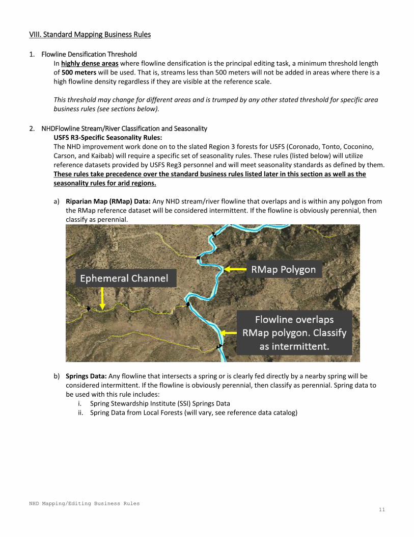
2. NHDFlowline Stream/River Classification and Seasonality USFS R3-Specific Seasonality Rules: The NHD improvement work done on to the slated Region 3 forests for USFS (Coronado, Tonto, Coconino, Carson, and Kaibab) will require a specific set of seasonality rules. These rules (listed below) will utilize reference datasets provided by USFS Reg3 personnel and will meet seasonality standards as defined by them. These rules take precedence over the standard business rules listed later in this section as well as the seasonality rules for arid regions. a) Riparian Map (RMap) Data: Any NHD stream/river flowline that overlaps and is within any polygon from
the RMap reference dataset will be considered intermittent. If the flowline is obviously perennial, then classify as perennial.
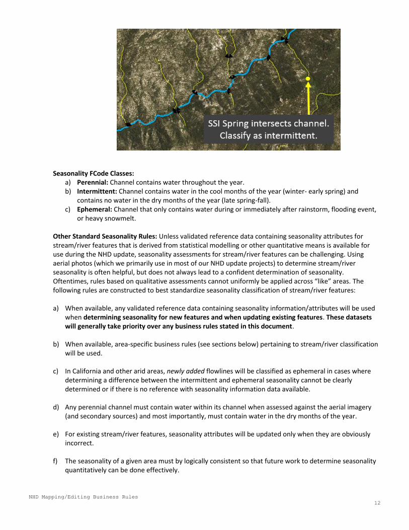
b) Springs Data: Any flowline that intersects a spring or is clearly fed directly by a nearby spring will be considered intermittent. If the flowline is obviously perennial, then classify as perennial. Spring data to be used with this rule includes:
i. Spring Stewardship Institute (SSI) Springs Data ii. Spring Data from Local Forests (will vary, see reference data catalog)
NHD Mapping/Editing Business Rules
12
Seasonality FCode Classes:
a) Perennial: Channel contains water throughout the year. b) Intermittent: Channel contains water in the cool months of the year (winter- early spring) and
contains no water in the dry months of the year (late spring-fall). c) Ephemeral: Channel that only contains water during or immediately after rainstorm, flooding event,
or heavy snowmelt. Other Standard Seasonality Rules: Unless validated reference data containing seasonality attributes for stream/river features that is derived from statistical modelling or other quantitative means is available for use during the NHD update, seasonality assessments for stream/river features can be challenging. Using aerial photos (which we primarily use in most of our NHD update projects) to determine stream/river seasonality is often helpful, but does not always lead to a confident determination of seasonality. Oftentimes, rules based on qualitative assessments cannot uniformly be applied across “like” areas. The following rules are constructed to best standardize seasonality classification of stream/river features: a) When available, any validated reference data containing seasonality information/attributes will be used
when determining seasonality for new features and when updating existing features. These datasets will generally take priority over any business rules stated in this document.
b) When available, area-specific business rules (see sections below) pertaining to stream/river classification
will be used.
c) In California and other arid areas, newly added flowlines will be classified as ephemeral in cases where determining a difference between the intermittent and ephemeral seasonality cannot be clearly determined or if there is no reference with seasonality information data available.
d) Any perennial channel must contain water within its channel when assessed against the aerial imagery (and secondary sources) and most importantly, must contain water in the dry months of the year.
e) For existing stream/river features, seasonality attributes will be updated only when they are obviously
incorrect. f) The seasonality of a given area must by logically consistent so that future work to determine seasonality
quantitatively can be done effectively.
NHD Mapping/Editing Business Rules
13
3. NHD Flowline Connector Usage Connector: A known, but nonspecific, invisible connection between two nonadjacent network segments. May be a named feature. Connectors will be used to maintain connectivity between flowlines when connectivity between upstream and downstream flowlines is known, but the exact physical pathway and feature that provides the connection is not known. Cases where connectors can be used include: a) Connect related flowlines across a small human settlement. b) Connect related flowlines across major roads and highways where culvert or underground feature is not
known. Note that the length of the connector must be digitizable at the editing scale, otherwise, no connector should be used.
c) Connect related flowlines that may have an extent of flow that goes underground and underground feature is not known, but clearly resurfaces further downstream.
In certain areas/landcover types, connector usage may have restrictions. See area-specific business rules below.
4. Lake/Pond and Reservoir Delineation a) Lakes, ponds, and reservoirs are to be added/modified where needed if they are visible and can be
assessed at the appropriate reference scale. At this scale, the minimum area of these features is approximately 1,200 square meters. Any feature too small that cannot be edited successfully at the editing scale will not be added/modified.
b) Lake/Pond Mapping: i. If water is present, but the lake bed is not filled:
1. Digitize to the mean high water mark of the lake bed. 2. Use: FType = Lake/Pond, FCode = Intermittent - High Water Elevation
ii. If water is present and the lake bed is filled AND the lake is perennial:
1. Digitize to the water mark, which reflects the entire lake bed. 2. Use: FType = Lake/Pond, FCode = Perennial 3. If it is not possible to determine if the feature is perennial, use: FType = Lake/Pond, FCode = No
Attributes
iii. If water is not present and the lake bed is generally not vegetated: 1. If water is not present and the lake bed is generally not vegetated: 2. Use: FType = Lake/Pond, FCode = Intermittent
iv. If there is a dam at the most downstream part of the Lake or Pond, refer to the next section on
inundation areas.
NHD Mapping/Editing Business Rules
14
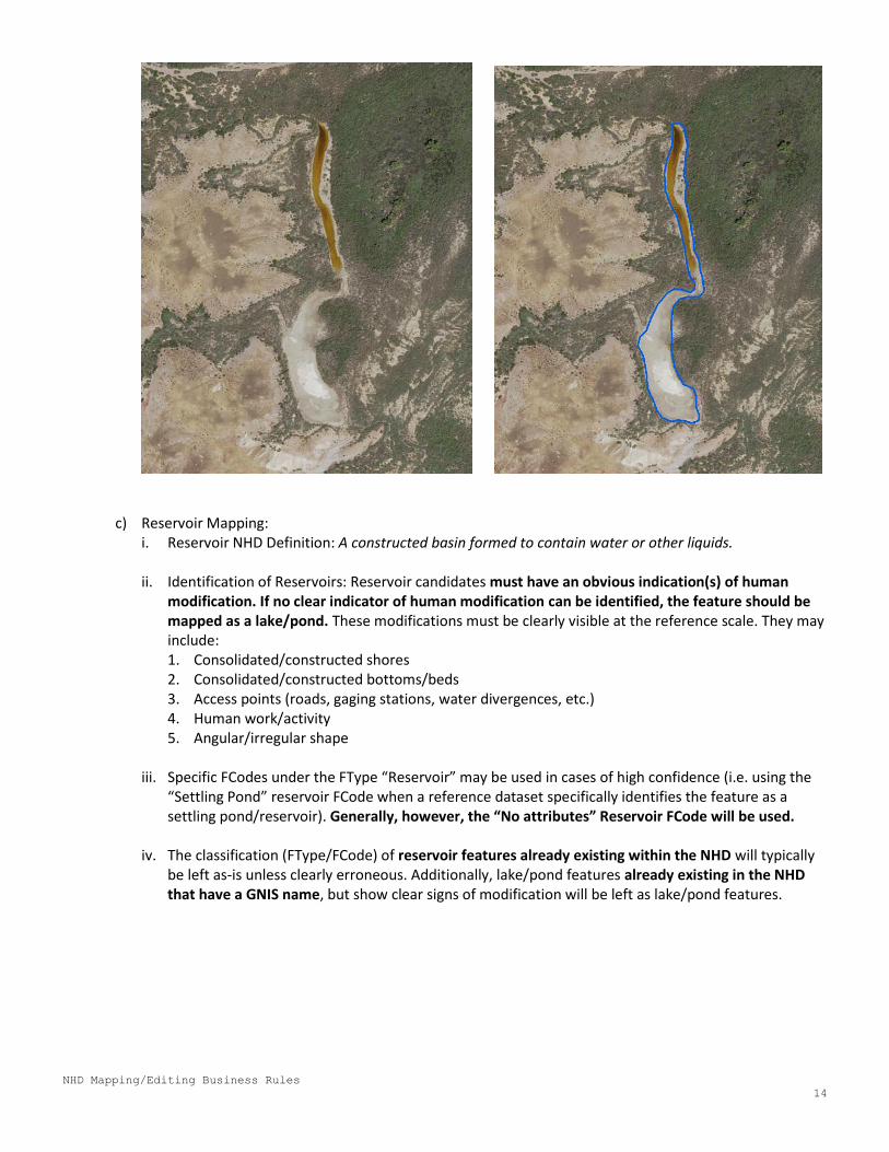
c) Reservoir Mapping: i. Reservoir NHD Definition: A constructed basin formed to contain water or other liquids. ii. Identification of Reservoirs: Reservoir candidates must have an obvious indication(s) of human
modification. If no clear indicator of human modification can be identified, the feature should be mapped as a lake/pond. These modifications must be clearly visible at the reference scale. They may include: 1. Consolidated/constructed shores 2. Consolidated/constructed bottoms/beds 3. Access points (roads, gaging stations, water divergences, etc.) 4. Human work/activity 5. Angular/irregular shape
iii. Specific FCodes under the FType “Reservoir” may be used in cases of high confidence (i.e. using the
“Settling Pond” reservoir FCode when a reference dataset specifically identifies the feature as a settling pond/reservoir). Generally, however, the “No attributes” Reservoir FCode will be used.
iv. The classification (FType/FCode) of reservoir features already existing within the NHD will typically
be left as-is unless clearly erroneous. Additionally, lake/pond features already existing in the NHD that have a GNIS name, but show clear signs of modification will be left as lake/pond features.
NHD Mapping/Editing Business Rules
15
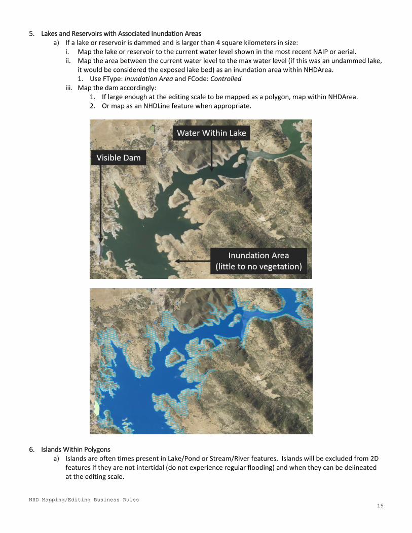
5. Lakes and Reservoirs with Associated Inundation Areas a) If a lake or reservoir is dammed and is larger than 4 square kilometers in size:
i. Map the lake or reservoir to the current water level shown in the most recent NAIP or aerial. ii. Map the area between the current water level to the max water level (if this was an undammed lake,
it would be considered the exposed lake bed) as an inundation area within NHDArea. 1. Use FType: Inundation Area and FCode: Controlled
iii. Map the dam accordingly: 1. If large enough at the editing scale to be mapped as a polygon, map within NHDArea. 2. Or map as an NHDLine feature when appropriate.
6. Islands Within Polygons a) Islands are often times present in Lake/Pond or Stream/River features. Islands will be excluded from 2D
features if they are not intertidal (do not experience regular flooding) and when they can be delineated at the editing scale.
NHD Mapping/Editing Business Rules
16
7. 2D Stream/River Mapping a) Streams and rivers will be mapped as 2D features if they can be digitized as polygons at the 1:15,000
scale. At this scale, the minimum width of streams and rivers mapped as 2D features is approximately 15 meters. If, at the 1:15,000 scale a stream or river is too narrow, it will be mapped as an NHDFlowline. As such, if an existing 2D stream/rive is inaccurate AND is not wide enough to be digitized at the editing scale, it will be deleted and a flowline will take its place.
8. Flowlines Within Polygons a) Flowlines within Lake/Pond Polygons:
i. Most flowlines within lake/pond features will be artificial paths. ii. Stream/river flowlines cannot exist within lake/pond polygons.
b) Flowlines within Wash Polygons:
i. If there is are any visible channels within the wash, they will be represented by a stream/river flowline with appropriate FCode.
ii. If there are no visible channels within the wash and flowline network connectivity needs to be maintained through the wash (i.e. connectivity between flowlines downstream and upstream through the wash and applicable lateral tributaries to the wash), artificial path flowlines will be used.
iii. Only the main channel and major braids will be added. Minor braids subject to seasonal and shape changes will not be added.
c) Flowlines within Swamp/Marsh Polygons: i. If there are any visible channels within the swamp/marsh, they will be represented by a
stream/river flowline with appropriate FCode. ii. If there are no visible channels within the swamp/marsh and flowline network connectivity needs
to be maintained through the swamp/marsh (i.e. connectivity between flowlines downstream and upstream through the swamp/marsh and applicable lateral tributaries to the swamp/marsh), artificial path flowlines will be used.
iii. Only the main channel and major braids will be added. Minor braids subject to seasonal and shape changes will not be added.
NHD Mapping/Editing Business Rules
17
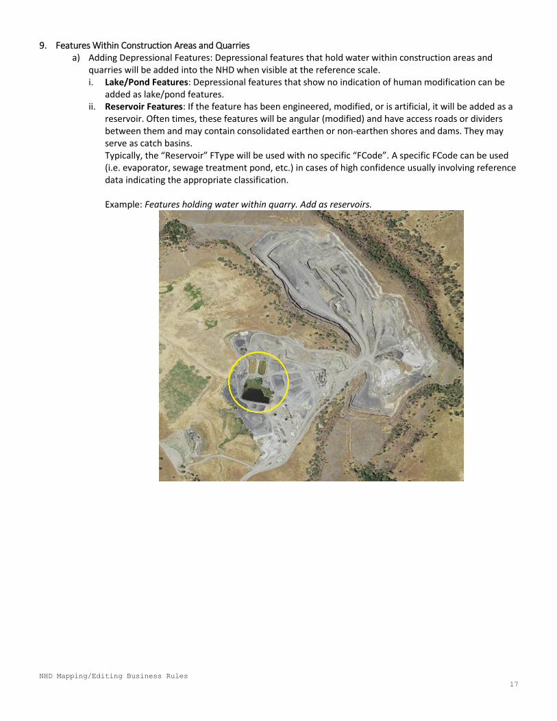
9. Features Within Construction Areas and Quarries a) Adding Depressional Features: Depressional features that hold water within construction areas and
quarries will be added into the NHD when visible at the reference scale. i. Lake/Pond Features: Depressional features that show no indication of human modification can be
added as lake/pond features. ii. Reservoir Features: If the feature has been engineered, modified, or is artificial, it will be added as a
reservoir. Often times, these features will be angular (modified) and have access roads or dividers between them and may contain consolidated earthen or non-earthen shores and dams. They may serve as catch basins. Typically, the “Reservoir” FType will be used with no specific “FCode”. A specific FCode can be used (i.e. evaporator, sewage treatment pond, etc.) in cases of high confidence usually involving reference data indicating the appropriate classification.
Example: Features holding water within quarry. Add as reservoirs.
NHD Mapping/Editing Business Rules
18
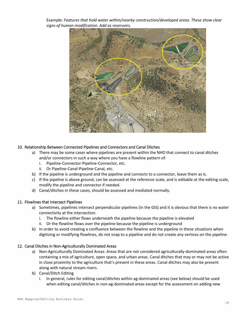
Example: Features that hold water within/nearby construction/developed areas. These show clear signs of human modification. Add as reservoirs.
10. Relationship Between Connected Pipelines and Connectors and Canal Ditches a) There may be some cases where pipelines are present within the NHD that connect to canal ditches
and/or connectors in such a way where you have a flowline pattern of: i. Pipeline-Connector-Pipeline-Connector, etc. ii. Or Pipeline-Canal-Pipeline-Canal, etc.
b) If the pipeline is underground and the pipeline and connects to a connector, leave them as is. c) If the pipeline is above ground, can be assessed at the reference scale, and is editable at the editing scale,
modify the pipeline and connector if needed. d) Canal/ditches in these cases, should be assessed and mediated normally.
11. Flowlines that Intersect Pipelines a) Sometimes, pipelines intersect perpendicular pipelines (in the GIS) and it is obvious that there is no water
connectivity at the intersection. i. The flowline either flows underneath the pipeline because the pipeline is elevated ii. Or the flowline flows over the pipeline because the pipeline is underground
b) In order to avoid creating a confluence between the flowline and the pipeline in these situations when digitizing or modifying flowlines, do not snap to a pipeline and do not create any vertices on the pipeline.
12. Canal Ditches in Non-Agriculturally Dominated Areas a) Non-Agriculturally Dominated Areas: Areas that are not considered agriculturally-dominated areas often
containing a mix of agriculture, open space, and urban areas. Canal ditches that may or may not be active in close proximity to the agriculture that’s present in these areas. Canal ditches may also be present along with natural stream rivers.
b) Canal/Ditch Editing i. In general, rules for editing canal/ditches within ag-dominated areas (see below) should be used
when editing canal/ditches in non-ag-dominated areas except for the assessment on adding new
NHD Mapping/Editing Business Rules
19
canal/ditches. In non-ag-dominated areas, these other factors may be used to help confirm that a feature is a canal/ditch:
1. Look for obvious signs of human use. 2. Look for consolidated shore along the banks of a canal/ditch candidate. 3. Look for signs that the canal/ditch candidate is engineered (i.e. is paved, angular, has access
points, etc.). 4. Consider proximity to crops. 5. Consider proximity to human settlements. 6. Assess name of WB in case it confirms the feature is a canal or ditch.
ii. In cases where a feature used to function as a canal/ditch, but is now obviously reverted back to a stream/river and is clearly no longer maintained or used as a canal ditch, it will be considered a stream/river feature.
13. Washes a) Washes will typically contain lighter color sediment indicating erosion. b) Generally, washes should be added when they are no more than 90% vegetated. If a wash candidate is
fully vegetated, it will not be added. i. A fully vegetated wash indicates that the wash is not active in terms of flooding and water load as the
vegetation has had time to establish and might be reverting to a drier state. Because of this, these wash candidates will not be added into the NHD.
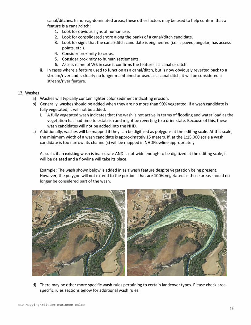
c) Additionally, washes will be mapped if they can be digitized as polygons at the editing scale. At this scale, the minimum width of a wash candidate is approximately 15 meters. If, at the 1:15,000 scale a wash candidate is too narrow, its channel(s) will be mapped in NHDFlowline appropriately As such, if an existing wash is inaccurate AND is not wide enough to be digitized at the editing scale, it will be deleted and a flowline will take its place. Example: The wash shown below is added in as a wash feature despite vegetation being present. However, the polygon will not extend to the portions that are 100% vegetated as those areas should no longer be considered part of the wash.
d) There may be other more specific wash rules pertaining to certain landcover types. Please check area-specific rules sections below for additional wash rules.
NHD Mapping/Editing Business Rules
20
IX. Area-Specific Business Rules: Agriculturally -Dominated Areas 1. Definition of Agriculture-Dominated Areas:
An area that contains primarily high-density agriculture. Likely to contain larger, perennial rivers with associated sloughs and marshes. Contains a large amount of canal and irrigation ditch systems and may contain reservoirs. These human-made systems often draw water from the perennial water sources in the area.
2. Canal/Ditch Editing:
i. Edits will generally be based on what is obvious and what can be determined with high certainty and high confidence based off the NHD Data in combination with the use of aerials/Bing/GoogleEarth/etc. When available, reference datasets will be used to aid in decision making for updating these features.
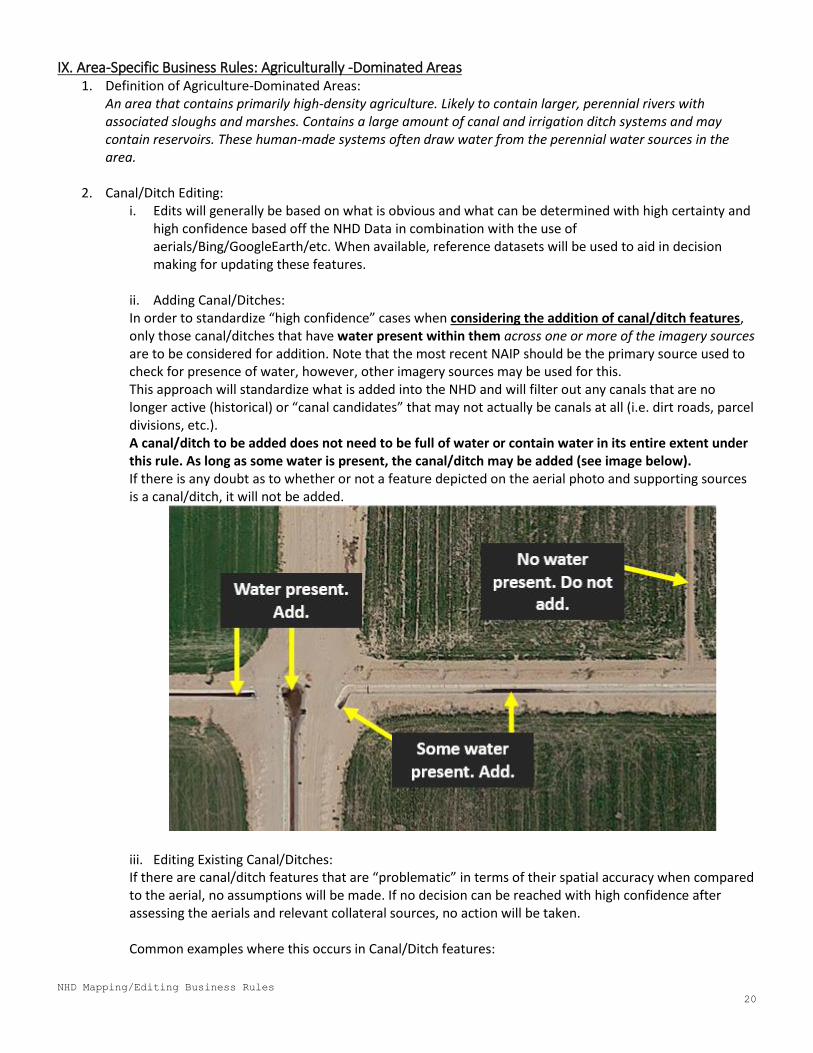
ii. Adding Canal/Ditches: In order to standardize “high confidence” cases when considering the addition of canal/ditch features, only those canal/ditches that have water present within them across one or more of the imagery sources are to be considered for addition. Note that the most recent NAIP should be the primary source used to check for presence of water, however, other imagery sources may be used for this. This approach will standardize what is added into the NHD and will filter out any canals that are no longer active (historical) or “canal candidates” that may not actually be canals at all (i.e. dirt roads, parcel divisions, etc.). A canal/ditch to be added does not need to be full of water or contain water in its entire extent under this rule. As long as some water is present, the canal/ditch may be added (see image below). If there is any doubt as to whether or not a feature depicted on the aerial photo and supporting sources is a canal/ditch, it will not be added.
iii. Editing Existing Canal/Ditches: If there are canal/ditch features that are “problematic” in terms of their spatial accuracy when compared to the aerial, no assumptions will be made. If no decision can be reached with high confidence after assessing the aerials and relevant collateral sources, no action will be taken.
Common examples where this occurs in Canal/Ditch features:
NHD Mapping/Editing Business Rules
21
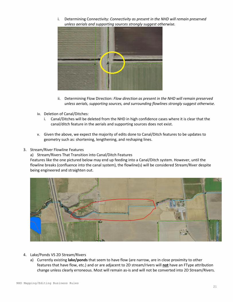
i. Determining Connectivity: Connectivity as present in the NHD will remain preserved unless aerials and supporting sources strongly suggest otherwise.
ii. Determining Flow Direction: Flow direction as present in the NHD will remain preserved
unless aerials, supporting sources, and surrounding flowlines strongly suggest otherwise.
iv. Deletion of Canal/Ditches: i. Canal/Ditches will be deleted from the NHD in high confidence cases where it is clear that the
canal/ditch feature in the aerials and supporting sources does not exist.
v. Given the above, we expect the majority of edits done to Canal/Ditch features to be updates to geometry such as: shortening, lengthening, and reshaping lines.
3. Stream/River Flowline Features
a) Stream/Rivers That Transition into Canal/Ditch Features Features like the one pictured below may end up feeding into a Canal/Ditch system. However, until the flowline breaks (confluence into the canal system), the flowline(s) will be considered Stream/River despite being engineered and straighten out.
4. Lake/Ponds VS 2D Stream/Rivers
a) Currently existing lake/ponds that seem to have flow (are narrow, are in close proximity to other features that have flow, etc.) and or are adjacent to 2D stream/rivers will not have an FType attribution change unless clearly erroneous. Most will remain as-is and will not be converted into 2D Stream/Rivers.
NHD Mapping/Editing Business Rules
22
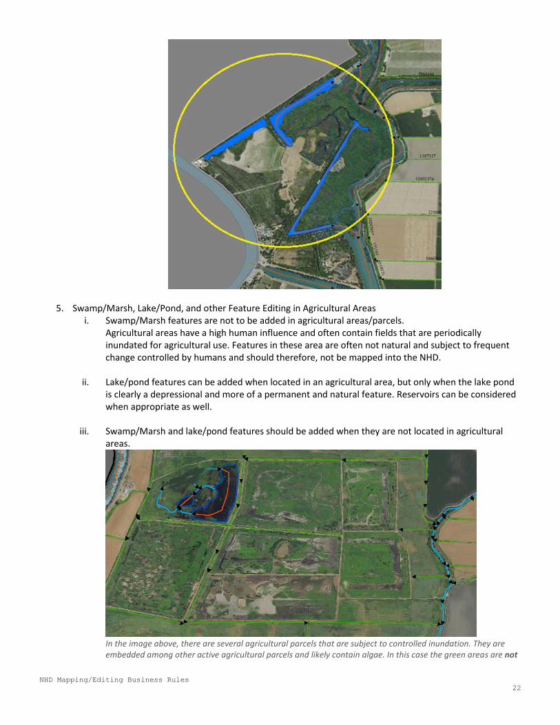
5. Swamp/Marsh, Lake/Pond, and other Feature Editing in Agricultural Areas i. Swamp/Marsh features are not to be added in agricultural areas/parcels.
Agricultural areas have a high human influence and often contain fields that are periodically inundated for agricultural use. Features in these area are often not natural and subject to frequent change controlled by humans and should therefore, not be mapped into the NHD.
ii. Lake/pond features can be added when located in an agricultural area, but only when the lake pond
is clearly a depressional and more of a permanent and natural feature. Reservoirs can be considered when appropriate as well.
iii. Swamp/Marsh and lake/pond features should be added when they are not located in agricultural areas.
In the image above, there are several agricultural parcels that are subject to controlled inundation. They are embedded among other active agricultural parcels and likely contain algae. In this case the green areas are not
NHD Mapping/Editing Business Rules
23
to be considered swamp/marsh features. The ponds in the upper left were added since they are depressional and more permanent features.
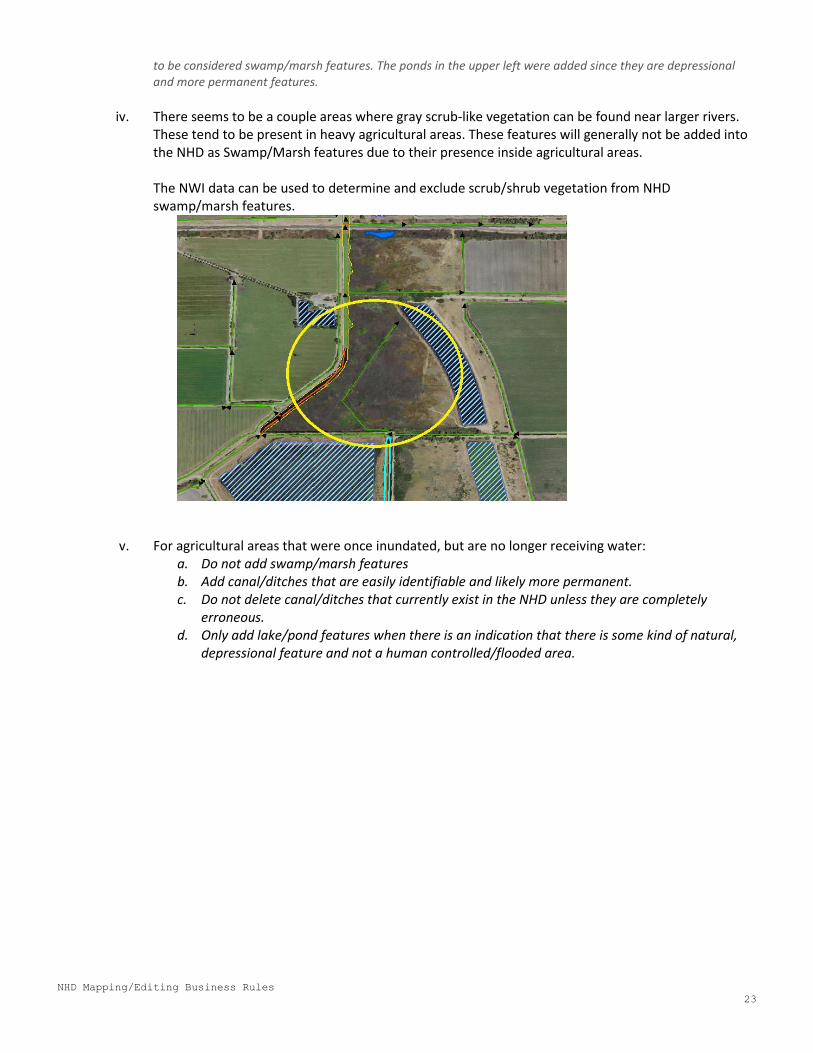
iv. There seems to be a couple areas where gray scrub-like vegetation can be found near larger rivers.
These tend to be present in heavy agricultural areas. These features will generally not be added into the NHD as Swamp/Marsh features due to their presence inside agricultural areas. The NWI data can be used to determine and exclude scrub/shrub vegetation from NHD swamp/marsh features.
v. For agricultural areas that were once inundated, but are no longer receiving water: a. Do not add swamp/marsh features b. Add canal/ditches that are easily identifiable and likely more permanent. c. Do not delete canal/ditches that currently exist in the NHD unless they are completely
erroneous. d. Only add lake/pond features when there is an indication that there is some kind of natural,
depressional feature and not a human controlled/flooded area.
NHD Mapping/Editing Business Rules
24
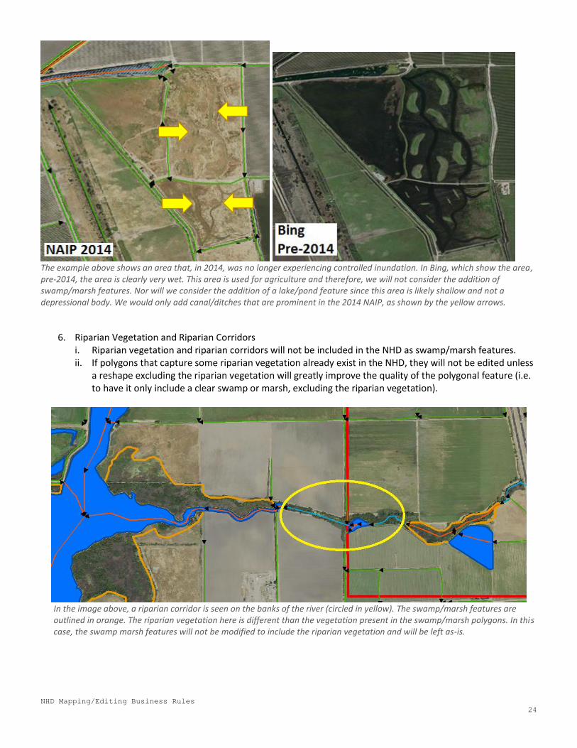
The example above shows an area that, in 2014, was no longer experiencing controlled inundation. In Bing, which show the area, pre-2014, the area is clearly very wet. This area is used for agriculture and therefore, we will not consider the addition of swamp/marsh features. Nor will we consider the addition of a lake/pond feature since this area is likely shallow and not a depressional body. We would only add canal/ditches that are prominent in the 2014 NAIP, as shown by the yellow arrows.
6. Riparian Vegetation and Riparian Corridors i. Riparian vegetation and riparian corridors will not be included in the NHD as swamp/marsh features. ii. If polygons that capture some riparian vegetation already exist in the NHD, they will not be edited unless
a reshape excluding the riparian vegetation will greatly improve the quality of the polygonal feature (i.e. to have it only include a clear swamp or marsh, excluding the riparian vegetation).
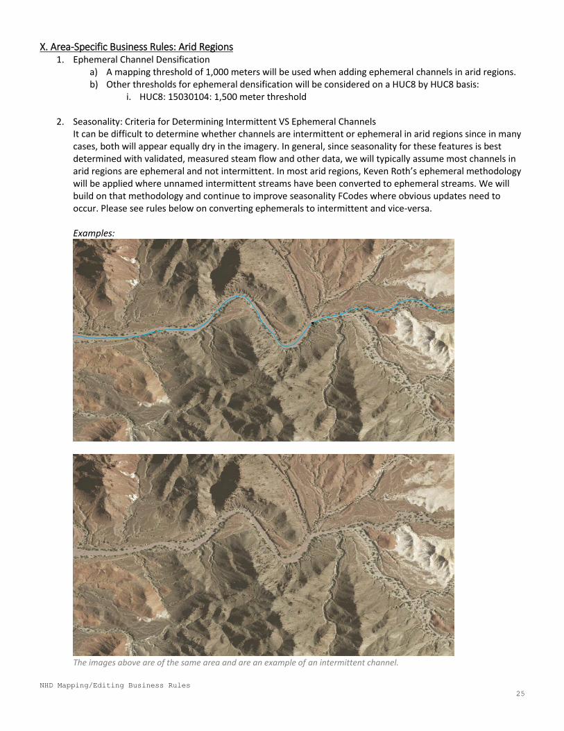
In the image above, a riparian corridor is seen on the banks of the river (circled in yellow). The swamp/marsh features are outlined in orange. The riparian vegetation here is different than the vegetation present in the swamp/marsh polygons. In this case, the swamp marsh features will not be modified to include the riparian vegetation and will be left as-is.
NHD Mapping/Editing Business Rules
25
X. Area-Specific Business Rules: Arid Regions 1. Ephemeral Channel Densification
a) A mapping threshold of 1,000 meters will be used when adding ephemeral channels in arid regions. b) Other thresholds for ephemeral densification will be considered on a HUC8 by HUC8 basis:
i. HUC8: 15030104: 1,500 meter threshold
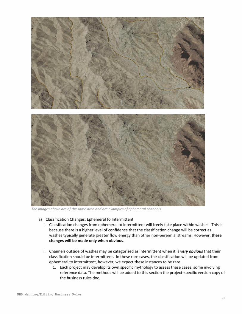
2. Seasonality: Criteria for Determining Intermittent VS Ephemeral Channels It can be difficult to determine whether channels are intermittent or ephemeral in arid regions since in many cases, both will appear equally dry in the imagery. In general, since seasonality for these features is best determined with validated, measured steam flow and other data, we will typically assume most channels in arid regions are ephemeral and not intermittent. In most arid regions, Keven Roth’s ephemeral methodology will be applied where unnamed intermittent streams have been converted to ephemeral streams. We will build on that methodology and continue to improve seasonality FCodes where obvious updates need to occur. Please see rules below on converting ephemerals to intermittent and vice-versa.
Examples:
The images above are of the same area and are an example of an intermittent channel.
NHD Mapping/Editing Business Rules
26
The images above are of the same area and are examples of ephemeral channels.
a) Classification Changes: Ephemeral to Intermittent
i. Classification changes from ephemeral to intermittent will freely take place within washes. This is because there is a higher level of confidence that the classification change will be correct as washes typically generate greater flow energy than other non-perennial streams. However, these changes will be made only when obvious.
ii. Channels outside of washes may be categorized as intermittent when it is very obvious that their classification should be intermittent. In these rare cases, the classification will be updated from ephemeral to intermittent, however, we expect these instances to be rare.
1. Each project may develop its own specific mythology to assess these cases, some involving reference data. The methods will be added to this section the project-specific version copy of the business rules doc.
NHD Mapping/Editing Business Rules
27
b) Classification Changes: Intermittent to Ephemeral i. Classification changes from intermittent to ephemeral will occur if the stream’s general
characteristics are similar to those of adjacent ephemeral streams. Additionally, if seasonality distinction between intermittent and ephemeral cannot be made, the ephemeral FCode will be used.
c) Criteria to Consider:
When assessing between the intermittent and ephemeral classification, consider the following criteria:
i. Presence of Water: Presence of water indicates wetter conditions. ii. Presence of Vegetation:
1. Presence: Presence of vegetation along streams may indicate wetter conditions. 2. Cover/Density: Denser vegetation or more vegetation cover may indicate wetter
conditions. 3. Type: On the aerials “fluffier”, more herbaceous vegetation may indicate wetter
conditions. This assessment can be supplemented by using CIR aerials (brighter pinks for wetter veg) and NWI data (specifically for the emergent vegetation classification) when useful.
iii. Channel Definition: Channels that are more defined demonstrate more erosion and thus, high energy water flow. This can aid in determining seasonality in conjunction with other factors.
iv. Soil Color/Texture: Changes in the color and texture of soil between the soil found within the channel and the soil adjacent to the channel can be assessed.
v. Adjacency to Perennial, Intermittent, and/or Wetland Features: Adjacency to wetter features may indicate overall wetter conditions.
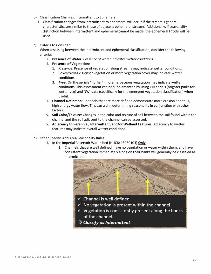
d) Other Specific Arid Area Seasonality Rules: i. In the Imperial Reservoir Watershed (HUC8: 15030104) Only:
1. Channels that are well defined, have no vegetation or water within them, and have consistent vegetation immediately along on their banks will generally be classified as intermittent.
NHD Mapping/Editing Business Rules
28
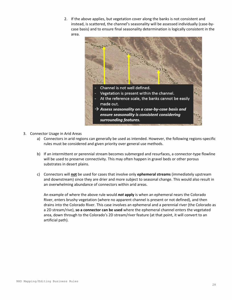
2. If the above applies, but vegetation cover along the banks is not consistent and instead, is scattered, the channel’s seasonality will be assessed individually (case-by-case basis) and to ensure final seasonality determination is logically consistent in the area.
3. Connector Usage in Arid Areas a) Connectors in arid regions can generally be used as intended. However, the following regions-specific
rules must be considered and given priority over general use methods.
b) If an intermittent or perennial stream becomes submerged and resurfaces, a connector-type flowline will be used to preserve connectivity. This may often happen in gravel beds or other porous substrates in desert plains.
c) Connectors will not be used for cases that involve only ephemeral streams (immediately upstream
and downstream) since they are drier and more subject to seasonal change. This would also result in an overwhelming abundance of connectors within arid areas. An example of where the above rule would not apply is when an ephemeral nears the Colorado River, enters brushy vegetation (where no apparent channel is present or not defined), and then drains into the Colorado River. This case involves an ephemeral and a perennial river (the Colorado as a 2D stream/rive), so a connector can be used where the ephemeral channel enters the vegetated area, down through to the Colorado’s 2D stream/river feature (at that point, it will convert to an artificial path).
NHD Mapping/Editing Business Rules
29
4. Wash Rules Adding Washes
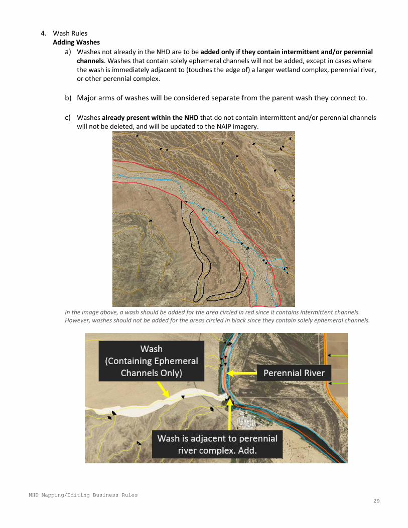
a) Washes not already in the NHD are to be added only if they contain intermittent and/or perennial channels. Washes that contain solely ephemeral channels will not be added, except in cases where the wash is immediately adjacent to (touches the edge of) a larger wetland complex, perennial river, or other perennial complex.
b) Major arms of washes will be considered separate from the parent wash they connect to.
c) Washes already present within the NHD that do not contain intermittent and/or perennial channels will not be deleted, and will be updated to the NAIP imagery.
In the image above, a wash should be added for the area circled in red since it contains intermittent channels. However, washes should not be added for the areas circled in black since they contain solely ephemeral channels.
NHD Mapping/Editing Business Rules
30
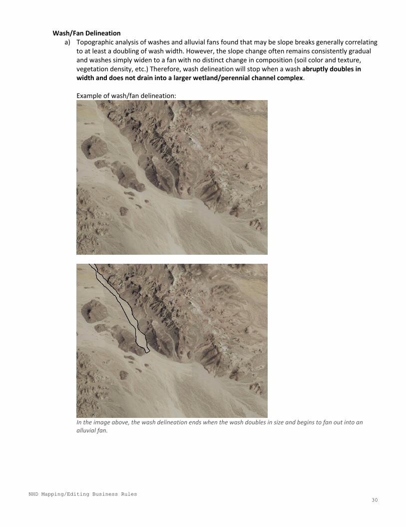
Wash/Fan Delineation a) Topographic analysis of washes and alluvial fans found that may be slope breaks generally correlating
to at least a doubling of wash width. However, the slope change often remains consistently gradual and washes simply widen to a fan with no distinct change in composition (soil color and texture, vegetation density, etc.) Therefore, wash delineation will stop when a wash abruptly doubles in width and does not drain into a larger wetland/perennial channel complex.
Example of wash/fan delineation:
In the image above, the wash delineation ends when the wash doubles in size and begins to fan out into an alluvial fan.
NHD Mapping/Editing Business Rules
31
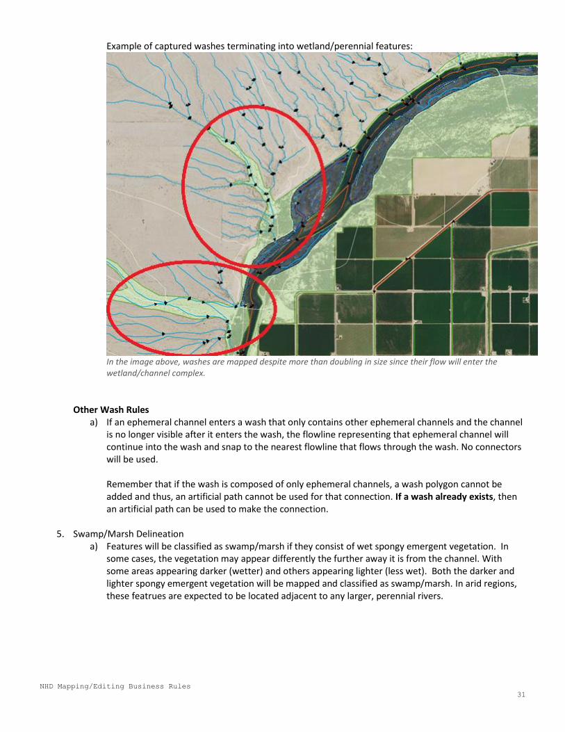
Example of captured washes terminating into wetland/perennial features:
In the image above, washes are mapped despite more than doubling in size since their flow will enter the wetland/channel complex.
Other Wash Rules
a) If an ephemeral channel enters a wash that only contains other ephemeral channels and the channel is no longer visible after it enters the wash, the flowline representing that ephemeral channel will continue into the wash and snap to the nearest flowline that flows through the wash. No connectors will be used. Remember that if the wash is composed of only ephemeral channels, a wash polygon cannot be added and thus, an artificial path cannot be used for that connection. If a wash already exists, then an artificial path can be used to make the connection.
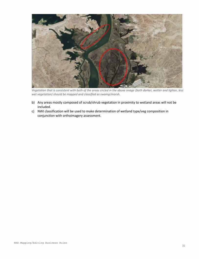
5. Swamp/Marsh Delineation a) Features will be classified as swamp/marsh if they consist of wet spongy emergent vegetation. In
some cases, the vegetation may appear differently the further away it is from the channel. With some areas appearing darker (wetter) and others appearing lighter (less wet). Both the darker and lighter spongy emergent vegetation will be mapped and classified as swamp/marsh. In arid regions, these featrues are expected to be located adjacent to any larger, perennial rivers.
NHD Mapping/Editing Business Rules
32
Vegetation that is consistent with both of the areas circled in the above image (both darker, wetter and lighter, less wet vegetation) should be mapped and classified as swamp/marsh.
b) Any areas mostly composed of scrub/shrub vegetation in proximity to wetland areas will not be included.
c) NWI classification will be used to make determination of wetland type/veg composition in conjunction with orthoimagery assessment.
NHD Mapping/Editing Business Rules
33
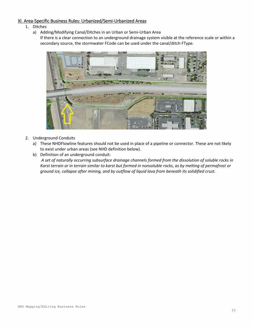
XI. Area-Specific Business Rules: Urbanized/Semi-Urbanized Areas 1. Ditches
a) Adding/Modifying Canal/Ditches in an Urban or Semi-Urban Area If there is a clear connection to an underground drainage system visible at the reference scale or within a secondary source, the stormwater FCode can be used under the canal/ditch FType.
2. Underground Conduits a) These NHDFlowline features should not be used in place of a pipeline or connector. These are not likely
to exist under urban areas (see NHD definition below). b) Definition of an underground conduit:
A set of naturally occurring subsurface drainage channels formed from the dissolution of soluble rocks in Karst terrain or in terrain similar to karst but formed in nonsoluble rocks, as by melting of permafrost or ground ice, collapse after mining, and by outflow of liquid lava from beneath its solidified crust.
NHD Mapping/Editing Business Rules
34
XII. Area-Specific Business Rules: Coastal Areas 1. Estuaries, Lagoons, and Their Related Complexes
a) NHD Definitions: i. Estuary: Under NHD, any estuary must have an obvious, open connection to the ocean. If connection
to the ocean is present, use the “Estuary” F-type for the NHD Waterbody polygon in question. Do not use the F-type it if there is no obvious open connection to the ocean.
ii. Coastal Lagoons, Lakes, etc.: If a body of water is closed off to the ocean (i.e. no obvious connection to the ocean is present), it will be generally considered a Lake/Pond feature under the NHDWaterbody FC.
b) Geometry Updates i. When assessing existing coastal areas, refer to the NWI reference layer to aid in distinguishing
between different feature types. ii. Those bodies of water within an estuarine complex that are not connected to the ocean will be
added as Lake/Pond features and will be digitized at the high mean water level (treated as a regular lake/pond feature).
iii. Estuaries may narrow, especially when they overlap highways and other human-made features and then widen up past those human features father inland. If there is clear connectivity across these features that may indicate tidal influence and saline water is present throughout AND the NWI data confirms this, the entire feature will be considered “estuary”. Otherwise, the feature upstream/father inland may be considered lake/pond and have a flowline connecting it to the true estuary.
c) Attribute Updates i. When assessing existing coastal areas, refer to the NWI reference layer to aid in distinguishing
between different feature types. 1. Use the WETLAND_TYPE field: Some features will be classified as estuarine and some are
freshwater (under the WETLAND_TYPE field in the attribute table). a) Estuarine types indicate saline water, which may help reaffirm which features should be
considered as estuaries. b) Freshwater types indicate no saline water, which may help reaffirm which features should be
considered as lake/ponds.
NHD Mapping/Editing Business Rules
35
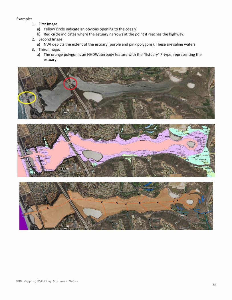
Example: 1. First Image:
a) Yellow circle indicate an obvious opening to the ocean. b) Red circle indicates where the estuary narrows at the point it reaches the highway.
2. Second Image: a) NWI depicts the extent of the estuary (purple and pink polygons). These are saline waters.
3. Third Image: a) The orange polygon is an NHDWaterbody feature with the “Estuary” F-type, representing the
estuary.