Embed Size (px)
Citation preview
NAT OPS Bulletin checklistYear2015_9June.docx
NAT OPS Bulletin Checklist Issued: 9 June 2015 Serial N° Subject - The following NAT OPS Bulletins are current - Effective date
NAT OPS BULLETIN for Year 2015
2015_003 RLatSM Special Emphasis Items 01 June 2015
2015_002 Reykjavik OCD Crew Procedures Version 4 01 February 2015
2015_001 Gander Data Link OCD Crew Procedures– Corrected Version 23rev1 13 January 2015
NAT OPS BULLETIN for Year 2014
2014_006 Implementation of 50NM Lateral Separation in Santa Maria Oceanic
CTA
20 February 2014
AIC published 6 Feb
14
2014_005 Automatic Dependent Surveillance-Broadcast Service in the Gander
Oceanic Control Area 18 February 2014
2014_004 Trial Implementation of RLatSM in the ICAO NAT Region 18 February 2014
2014_002 Oceanic Errors Safety Bulletin 04 February 2014
2014_001 Sample Oceanic Checklists 04 February 2014
NAT OPS BULLETIN for Year 2013
2013_005 New Service Notification for Gander Oceanic Control Area 21 November 2013
2013_002 Publication of “Track Wise – Targeting Risk within the Shanwick
OCA” – updated 29th April 2013
29 April 2013
2013_001 Information and Guidance for Data Link Oceanic Clearance Delivery
in Santa Maria Oceanic Control Area 28 January 2013
NAT OPS BULLETIN for Year 2012
2012-031 NAT Region Data Link Mandate 30 November 2012
2012-030 Reduced Longitudinal Separation Minimum (RLongSM) Trial 17 September 2012
2012-027 Trial of a Five-Minute Along Track Longitudinal Separation Minimum
in the Gander Oceanic Control Area 03 May 2012
2012-026 Trial of a 5 Minute Along Track Longitudinal Separation in the
Shanwick OCA 16 March 2012
NAT OPS BULLETIN for Year 2010
2010-012 Improving understanding FANS 1/A DL procedures NAT Region 21 June 2010
NAT OPS BULLETIN for Year 2009
2010-007 Flight crew guidance – 5 minutes separation between GNSS aircraft September 2009
NAT OPS BULLETIN for Year 2004
2010-006 ORCA Procedures for Shanwick 18 March 2004
NAT OPS Bulletin 2015_003 SEI RLatSM.docx
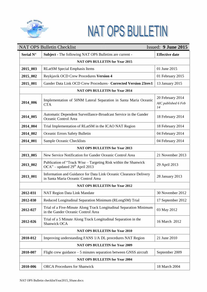
Serial Number: 2015_003
Subject: RLatSM Special Emphasis
Items
Effective: 1 June 2015
The purpose of North Atlantic Operations Bulletin 2015_003 is to provide guidance to North Atlantic (NAT)
operators on material to be included in pilot and dispatcher training programs and operations manuals to
prepare them for operations in the North Atlantic under Reduced Lateral Separation of 25 Nautical Miles
(NAT RLatSM). This Bulletin may be updated, as necessary, as progress is made toward the start date for
Phase 1 of the RLatSM trial
Any queries about the content of the attached document should be addressed to:
ICAO EUR/NAT Office: [email protected]
Roy Grimes: [email protected]
NOTICE NAT Ops Bulletins are used to distribute information on behalf of the North Atlantic Systems Planning
Group (NAT SPG). The material contained therein may be developed within the working structure of the
NAT SPG or be third party documents posted at the request of a NAT SPG Member State. A printed or
electronic copy of this Bulletin, plus any associated documentation, is provided to the recipient as is and
without any warranties as to its description, condition, quality, fitness for purpose or functionality and for use
by the recipient solely for guidance only. The information published by ICAO in this document is made
available without warranty of any kind; the Organization accepts no responsibility or liability whether direct
or indirect, as to the currency, accuracy or quality of the information, nor for any consequence of its use. The
designations and the presentation of material in this publication do not imply the expression of any opinion
whatsoever on the part of ICAO concerning the legal status of any country, territory, city or area of its
authorities, or concerning the delimitation of its frontiers or boundaries.
The NAT OPS Bulletin Checklist is available at www.icao.int/EURNAT/ EUR & NAT Documents, NAT
Documents, then NAT Ops Bulletins.
There is no objection to the reproduction of extracts of information contained in this Bulletin if the source is
acknowledged.
2 NAT OPS Bulletin 2015-003 – RLatSM Special Emphasis Items 2
NAT OPS Bulletin 2015_003 SEI RLatSM.docx
NAT OPERATIONS BULLETIN – RLATSM SPECIAL EMPHASIS ITEMS
1. Purpose of Bulletin. The purpose of this bulletin is to provide guidance to North Atlantic (NAT)
operators on material to be included in pilot and dispatcher training programs and operations manuals to
prepare them for operations in the North Atlantic under Reduced Lateral Separation of 25 Nautical Miles
(NAT RLatSM operations).
1.1 This Bulletin may be updated, as necessary, as progress is made toward the start date for Phase 1 of
the RLatSM trial. Any necessary updates will be distributed through industry organizations and posted on
the ICAO EUR/NAT Website. (See section 6).
1.2 See Attachment A for a summary listing of RLatSM Special Emphasis Items contained in this
bulletin.
1.3 The following is an explanation of the terms “should”, “must” and “shall” as used in this bulletin.
a) “Should” is used to indicate a recommended practice or policy that is considered as
desirable for the safety of operations.
b) “Shall” and “must” are used to indicate a practice or policy that is considered as
necessary for the safety of operations.
2. RLatSM Project Plan Overview. On or soon after 12 November 2015, Phase 1 of the NAT 25
NM Reduced Lateral Separation Minimum (RLatSM) trial is planned to commence in portions of the
Gander and Shanwick oceanic control areas (OCA). During the RLatSM Phase 1 trial:
a) The 25 NM lateral separation minimum will be implemented by applying ½ degree
track spacing between three core NAT Organized Track System (OTS) tracks. 25
NM lateral separation will be applied between flight level (FL) 350-390 (inclusive).
b) OTS tracks separated using the reduced lateral separation minimum will be established by
publishing one track defined by ½ degree waypoints (e.g., 54 degrees-30 minutes NORTH
latitude/50 degrees WEST longitude) between two adjacent tracks defined by whole degree
waypoints (e.g. 54 degrees NORTH latitude/50 degrees WEST longitude, respectively).
c) Only those operators/aircraft eligible for RLatSM operations will be allowed to operate
on designated RLatSM tracks between FL 350-390 (inclusive). See section 3
(Operator/Aircraft Eligibility).
d) Strategic Lateral Offset Procedures (SLOP) will continue to be used in accordance with
NAT Doc 007, paragraph 8.5
e) Enhanced ATC surveillance and communication will be provided via FANS 1/A (or
equivalent) data link systems. Automatic Dependent Surveillance (ADS-C) will provide
route conformance monitoring, periodic aircraft reporting and controller alerts for Lateral
Deviation Events (LDE) and vertical deviation events (Level Range Deviation Events
(LRDE). Controller-Pilot Data Link Communications (CPDLC) will enhance ATC
intervention and communication capabilities.

3 NAT OPS Bulletin 2015-003 – RLatSM Special Emphasis Items 3
NAT OPS Bulletin 2015_003 SEI RLatSM.docx
3. Operator/Aircraft Eligibility. Operators do not need to apply to NAT ANSPs to be part of the
trial, however, operators should consult with the State authority responsible for their operation prior to
starting RLatSM operations. Operators will be eligible to flight plan and fly RLatSM tracks provided the
flights are:
a) Authorized Required Navigation Performance 4 (RNP 4)
b) ADS-C and CPDLC equipped and, where applicable, authorized; and,
c) Operating required Communications, Navigation and Surveillance (CNS) systems
Note: Job Aids for RNP 4 and Data Link operations authorization are posted on the ICAO European and
North Atlantic (EUR/NAT) Office website. See section 6 below – Websites.
4. Flight Planning Provisions
4.1 Only those operators/aircraft eligible for RLatSM operations will be allowed to operate on
designated RLatSM tracks between FL 350-390 (inclusive). All RLatSM tracks and FLs will be uniquely
identified in Remark 3 of the OTS Track Message as shown below:
Westbound NAT Track Message Example with RLatSM Tracks
(Underlined-bold text highlights RLatSM tracks. It will not be bold in the actual OTS messages)
FF CYZZWNAT 102151 EGGXZOZX (NAT-1/3 TRACKS FLS 310/390 INCLUSIVE FEB 11/1130Z TO FEB 11/1900Z PART ONE OF THREE PARTS- A PIKIL 57/20 58/30 59/40 58/50 DORYY EAST LVLS NIL WEST LVLS 310 320 330 340 350 360 370 380 390 EUR RTS WEST NIL NAR NIL- B RESNO 56/20 57/30 58/40 57/50 HOIST EAST LVLS NIL WEST LVLS 310 320 330 340 350 360 370 380 390 EUR RTS WEST NIL NAR NIL- C VENER 5530/20 5630/30 5730/40 5630/50 IRLOK EAST LVLS NIL WEST LVLS 350 360 370 380 390 EUR RTS WEST NIL NAR NIL- END OF PART ONE OF THREE PARTS)
FF CYZZWNAT 102151 EGGXZOZX (NAT-2/3 TRACKS FLS 310/390 INCLUSIVE FEB 11/1130Z TO FEB 11/1900Z PART TWO OF THREE PARTS- D DOGAL 55/20 56/30 57/40 56/50 JANJO EAST LVLS NIL WEST LVLS 310 320 330 340 350 360 370 380 390 EUR RTS WEST NIL NAR NIL-
E MALOT 54/20 55/30 56/40 55/50 LOMSI EAST LVLS NIL WEST LVLS 310 320 330 340 350 360 370 380 390 EUR RTS WEST NIL NAR NIL- END OF PART TWO OF THREE PARTS)
FF CYZZWNAT 102152 EGGXZOZX (NAT-3/3 TRACKS FLS 310/390 INCLUSIVE FEB 11/1130Z TO FEB 11/1900Z PART THREE OF THREE PARTS- REMARKS. 1. TMI IS 042 AND OPERATORS ARE REMINDED TO INCLUDE THE TMI NUMBER AS PART OF THE OCEANIC CLEARANCE READ BACK. 2. ADS-C AND CPDLC MANDATED OTS ARE AS FOLLOWS TRACK A 350 360 370 380 390 TRACK B 350 360 370 380 390 TRACK C 350 360 370 380 390 TRACK D 350 360 370 380 390 TRACK E 350 360 370 380 390 END OF ADS-C AND CPDLC MANDATED OTS 3. RLATSM OTS TRACKS AND FLIGHT LEVELS ARE AS FOLLOWS TRACK B 350 360 370 380 390 TRACK C 350 360 370 380 390 TRACK D 350 360 370 380 390 …
4.2 Operators must file the correct ICAO Flight Plan annotations in Items 10 and 18 to indicate that
RLatSM required CNS systems are operational for the flight.
a) Item 10a (Radio communication, navigation and approach aid equipment and capabilities).
• Insert “J5” to indicate FANS 1/A (or equivalent) Inmarsat CPDLC SATCOM and/or “J7” to
indicate FANS 1/A (or equivalent) CPDLC Iridium SATCOM data link equipage and
operation;
4 NAT OPS Bulletin 2015-003 – RLatSM Special Emphasis Items 4
NAT OPS Bulletin 2015_003 SEI RLatSM.docx
b) Item 10b (Surveillance equipment and capabilities)
• Insert “D1” to indicate FANS 1/A (or equivalent) ADS-C equipage and operation
c) Item 18 (Other information)
• Insert the characters “PBN/” followed by “L1” to indicate RNP 4 authorization.
5. Special Emphasis Items for RLatSM Operators. The Special Emphasis Items (SEI) listed below
should be incorporated into operator training programs and operations manuals with the intent of raising
pilot and dispatcher awareness of the importance of following procedures in an environment where ½
degree waypoints and a lateral separation minimum of 25 NM are applied. Each SEI is followed by an
explanation of the factors leading it to be identified as an RLatSM SEI.
5.1 Requirement to use the CNS equipment that is indicated in the ICAO flight plan:
ATC uses the Flight Plan annotations in Items 10 and 18 to apply the reduced separation between
aircraft. Therefore, before entering the NAT, the pilot must ensure that:
1. the aircraft is logged on when data link capability (J5, J7, D1) has been filed in the FPL; and
2. RNP 4 is inserted into the FMC, when RNP4 capability (L1) has been filed in the FPL. This
is to enable aircraft navigation system monitoring and alerting against the required RNP 4
Navigation Specification.
5.2 Pilot Training on Map and FMC Displays of ½ Degree and Whole Degree Waypoints:
To mitigate misinterpretation of waypoint coordinates, operator initial and re-current training
programs and operations manuals must incorporate training and guidance to enable pilots to
understand map and FMC displays of ½ degree and whole degree waypoints.
Explanation
5.2.1 Map displays and certain FMC pages generally do not display full waypoint degrees and minutes,
e.g. when the full 13 latitude/longitude characters are used to insert ½ degree waypoints. See Figure 1,
Figure 2, and Figure 3, in Attachment B.
5.3 Aircraft Navigation Database (NDB) Waypoint Identifiers:
It is strongly advocated that aircraft NDB vendors and flight planning services not provide
operators with half-degree waypoint identifiers in the ARINC 424, paragraph 7.2.5 “N-prefix”
format (e.g., N5250 = 52o30’ NORTH 050
o00’WEST).
NAT operators should use a full latitude/longitude (e.g., 13-character) input for waypoints
containing both half-degree and whole degrees of latitude and whole degrees of longitude, when
they are required to make a manual input of waypoints, unless they have the operational need
discussed below.
NAT operators with an operational need to populate the aircraft NDB with a 5-character
waypoint identifier should ensure that the aircraft NDB vendors and flight planning services use an
alternate half-degree of latitude 5-character format such as Hxxyy, where xx = degrees and 30
minutes of NORTH latitude and yy = degrees of WEST longitude (e.g., H5250 = 52o30’ NORTH
050o00’ WEST). (It is recognized that, for whole degree waypoint inputs, such operators will likely
continue using the ARINC 424, 7.2.5 “N-suffix” format (e.g., 5250N = 52o
00’ NORTH
050o00’WEST)).
It is recognized that such alternate formats may be available from NDB vendors beginning two
Aeronautical Information Regulation and Control (AIRAC) cycles before the scheduled start of the
5 NAT OPS Bulletin 2015-003 – RLatSM Special Emphasis Items 5
NAT OPS Bulletin 2015_003 SEI RLatSM.docx
RLatSM trial. The scheduled start date is 12 November 2015 (AIRAC 1512), therefore,
implementation of alternate formats could be as early as 17 September 2015 (AIRAC 1510).
Note. The NAT ANSPs are implementing CPDLC route clearance policies and capabilities that
will mitigate the need for pilots to manually insert waypoint coordinates.
Explanation
5.3.1 Half-degree waypoint identifiers in the ARINC 424, paragraph 7.2.5 “N-prefix” format have led to
a number of Gross Navigation Errors (GNEs) and Lateral Deviations. The guidance for waypoint insertion
in paragraph 5.3 above is intended to remove the potential for such errors. They occur when a pilot
intending to input a waypoint defined by a half-degree of latitude inadvertently loads a waypoint
containing a whole-degree of latitude, or vice versa, because the “N” is not loaded in the correct pre-fix or
suffix position.
5.4 Pilot Procedures for Verifying Waypoint Degrees and Minutes Inserted into Aircraft Navigation
Systems:
Procedures must be used to display and verify the DEGREES and MINUTES loaded into the Flight
Management Computer (FMC) for the “un-named” (Lat/Long) waypoints defining the route
contained in the oceanic clearance. (The “Sample Oceanic Checklist” NAT OES Bulletin refers).
Regardless of FMC waypoint format and entry method, crew procedures should be designed to
promote strong crew resource management techniques, to prevent opportunities for error occurring
as a result of confirmation bias and to generally maintain an attitude of healthy suspicion.
Accordingly, the waypoint verification procedures should be conducted as detailed below.
During pre-flight LRNS programming, both pilots independently verify the full latitude and
longitude coordinates of “un-named” (Lat/Long) waypoints defining the expected route of flight
within oceanic airspace as entered in the FMC.
Upon receipt of a revised oceanic clearance (i.e., one not conforming to the flight planned
route), both pilots independently verify the full latitude and longitude coordinates of “un-
named” (Lat/Long) waypoints defining the route contained in the revised oceanic clearance.
Approaching an oceanic waypoint, one pilot should verify the full latitude and longitude
coordinates of that waypoint in the FMC, the NEXT and NEXT +1 waypoints, while the other
pilot crosschecks the latitude and longitude coordinates against the master flight plan/oceanic
clearance.
Explanation
5.4.1 Due to the factors in the map and FMC display of ½ degree and whole degree waypoints, it is
imperative that pilots follow the procedure in paragraph 5.4 above to avoid lateral errors caused by incorrect
insertion of waypoints. Verification of the full DEGREES and MINUTES of oceanic waypoints loaded
into the FMC is a critical step in ensuring a proper navigational load.
5.5 Pilot Track and Distance Check:
It is strongly recommended that pilot pre-flight and in-flight procedures call for the pilot to compare
the track and distance between waypoints shown on the Computer Flight Plan (CFP) to those
displayed by the FMC. (The NAT “Sample Oceanic Checklist” Bulletin refers).
Pilots should be aware that waypoint insertion errors of ½ degree of latitude may in some cases
result in only small differences in track and distance, however, the track and distance check can help
prevent waypoint insertion errors of one degree or more that have been observed in oceanic
operations.
6 NAT OPS Bulletin 2015-003 – RLatSM Special Emphasis Items 6
NAT OPS Bulletin 2015_003 SEI RLatSM.docx
Note: `the currency of magnetic variation tables loaded into aircraft navigation databases and the
point at which the track is measured affect the track displayed on the FMC by as much as ±3
degrees.
Explanation
5.5.1 This check remains valuable for RLatSM operations because waypoint insertion errors are not
limited to ½ degree errors and waypoint insertion errors of one degree or more have been observed in
oceanic operations. Waypoint insertion errors of ½ degree produce a small difference in leg segment track
and distance, however, as noted above, waypoint insertion errors are not limited to ½ degree.
5.6 Pilot Action When Notified By ATC of Possible Deviation from Cleared Track:
Flight crews are advised that, should they be notified that ATC systems indicate the aircraft is not
flying the cleared route, they should immediately display the full degrees and minutes loaded into
the FMC for the NEXT and NEXT + 1 waypoints, and verify against the cleared route before
responding.
Voice message example: “SHANWICK CONFIRMS YOUR POSITION REPORT INDICATES
INCORRECT ROUTING. CHECK FULL DEGREES AND MINUTES LOADED INTO FMC.
YOUR CLEARED ROUTE IS [route]”
CPDLC message example:
YOUR POSITION REPORT INDICATES INCORRECT ROUTING. CHECK FULL
DEGREES AND MINUTES LOADED INTO FMC. YOUR CLEARED ROUTE IS [route]
When ATC notifies the pilot that the aircraft has indicated it has already deviated from the cleared
track (UM169f: ADS-C INDICATES OFF ROUTE. ADVISE INTENTIONS), the pilot shall
immediately display the full DEGREES and MINUTES loaded into the FMC for the NEXT
waypoint, and verify against the cleared route.
5.7 Policy for Operational Airborne Collision Avoidance System II (ACAS II):
Prior to departure for flight on an NAT OTS track at a flight level where RLatSM is applied, the
ACAS II system shall be fully operational for the pilot flying (i.e., the TA and RA visual display
and audio function will be operative for the pilot flying). If the ACAS II system is not fully
operational for the pilot flying, the operator has the option of requesting clearance to operate on a
track and/or at a FL where RLatSM is not applied. If the ACAS II system fails after departure, the
aircraft may continue on the cleared route.
Note: The ACAS II (TCAS II) system must be a Version 7.0 or more recent version).
Explanation
5.7.1 ACAS II provides a valuable situational awareness tool and safety net for pilots operating in NAT
airspace including those where aircraft separation standards have already been reduced in the vertical and
longitudinal dimensions. The carriage and operation of ACAS II is emphasized here in the context of
RLatSM trials for the following reasons:
a) The introduction of ½ degree OTS waypoints is an operational change that introduces the use
of ½ degree waypoints into NAT OTS operations. Although both pilot procedures and ADS-C
conformance monitoring capabilities should mitigate the occurrence of lateral deviations
related to ½ degree waypoints, ACAS II provides an independent margin of safety should
lateral deviations occur during the RLatSM trial period.
b) ACAS II will provide a situational awareness tool that will enable pilots to be better prepared
to safely execute weather deviation and contingency procedures necessitating lateral deviations
7 NAT OPS Bulletin 2015-003 – RLatSM Special Emphasis Items 7
NAT OPS Bulletin 2015_003 SEI RLatSM.docx
(e.g., diversions and turn-backs). In the RLatSM operational environment, such deviations will
occur in airspace where the minimum lateral separation is to be 25 NM.
5.8 Pilot In-flight Contingency Procedures and Weather Deviation Procedures (Diversions, Turn-
backs, etc.):
In training and checking programs, operators shall place special emphasis on pilot knowledge of and
preparation to execute the Special Procedures for Inflight Contingencies in Oceanic Airspace
published in ICAO Doc 4444, paragraph 15.2 and Weather deviation procedures (paragraph 15.2.3).
Pilots must be aware that when crossing adjacent tracks without an ATC clearance, the potential
vertical separation provided by the In-flight Contingency Procedure is 500 ft. Pilots must use all the
steps called for in the Contingency Procedures to avoid conflict with other aircraft.
Pilots must also be aware that when unable to obtain an ATC clearance, Weather Deviation
Procedures call for a climb or descent of 300 ft. based on direction of flight and direction of
deviation, and, in addition, guidance to the pilot is to adjust the path of the aircraft, if necessary, to
avoid aircraft at or near the same flight level.
Pilots must stringently follow all measures for avoiding conflict with other aircraft provided for in
the Doc 4444 Contingency and Weather Deviation Procedures.
Explanation
5.8.1 The implementation of RLatSM (25 NM) separation and ½ degree track spacing significantly
reduces the distance and time a diverting aircraft has to manoeuvre when executing a diversion, turn-back or
weather deviation without an ATC clearance before approaching adjacent tracks. It also reduces the time
that a pilot has to obtain an ATC clearance. (An aircraft deviating from track can be in the proximity of
aircraft on an adjacent track within approximately 4 minutes, depending on the angle of deviation from
cleared track). In addition, as discussed above, the margin for safety for aircraft crossing adjacent tracks is
150 m (500 ft.) of vertical separation when executing In-flight Contingency Procedures.
5.9 RLatSM Operational policies (aircraft CNS system failure, data link system failure, etc.):
5.9.1 Objective. The guidance provided in section 5.9 is intended to apply during the RLatSM trials that
are scheduled to start on 12 November 2015. It is intended to supplement the Global Operational Data Link
Document (GOLD) guidance to controllers and flight crew on data link service failures and aircraft data link
system failures (GOLD paragraphs 4.9.4 and 5.9.4 respectively).
5.9.2 RLatSM Required CNS System Failure Prior to Departure. If a flight experiences a failure of an
RLatSM required CNS system PRIOR TO DEPARTURE, the flight should flight plan so as to remain
clear of NAT RLatSM tracks between FL 350-390 (inclusive).
5.9.3 RLatSM Required CNS System Failure After Departure But Prior to Entering On To
RLatSM Tracks Between FL 350-390 (Inclusive). If a flight experiences a failure of an RLatSM required
CNS system AFTER DEPARTURE BUT PRIOR TO ENTERING RLATSM AIRSPACE, the flight
should contact ATC and request a revised clearance that will keep it clear of NAT RLatSM tracks between
FL 350- 390 (inclusive).
5.9.4 RLatSM Required CNS System Failure After Entering On To RLatSM Tracks Between FL
350-390 (Inclusive). If a flight experiences a failure of an RLatSM required CNS system WHILE
OPERATING IN RLATSM AIRSPACE, ATC must be immediately advised. Such flights may be re-
cleared to exit RLatSM airspace, but consideration will be given to allowing the flight to remain in the
airspace, based on tactical considerations. (GOLD paragraph 4.9.4.8 refers).
5.9.5 Continuous Climb or Descent of Aircraft Not RLatSM Eligible. Any aircraft that is not RLatSM
eligible may request continuous climb or descent without intermediate level off through the vertical extent
of the NAT RLatSM airspace. Such requests will be considered on a tactical basis.
8 NAT OPS Bulletin 2015-003 – RLatSM Special Emphasis Items 8
NAT OPS Bulletin 2015_003 SEI RLatSM.docx
5.9.6 Altitude Reservation (ALTRV) Requests. ALTRV requests will be considered on a case by case
basis (as is done today regarding NAT MNPS airspace), irrespective of the RLatSM eligibility status of the
participating aircraft.
5.9.7 Contingency Situations. NAT RLatSM airspace restrictions are not applicable to aircraft
experiencing a contingency situation.
5.10 Domestic ATC Agency Contact:
Pilots are reminded to ensure that they contact the appropriate domestic ATC agency BEFORE
exiting oceanic airspace.
6. Websites
6.1 The ICAO EUR/NAT Office Website is at: www.icao.int/eurnat. Click on EUR & NAT
Documents >> NAT Documents to obtain NAT Operations and NAT Region Update Bulletins and related
project planning documents.
6.2 Job Aid Templates. Click on EUR & NAT Documents >> NAT Documents >> Job Aid
Templates for:
a) RNP 4 Job Aid Template (Application to conduct RNP 4 operations), and,
b) Data Link Job Aid Template (Operator Application to Conduct Data Link Operations).
7. Contacts
7.1 The following individuals may be contacted for information or to provide feedback on
RLatSM operations:
UK NATS
Jamie Hutchison
GM Prestwick Operations
E-mail: [email protected]
NAV CANADA
Gander Area Control Centre
P.O. Box 328
Gander, NL A1V 1W7
Attn: Jeffrey Edison
Manager, ACC Operations
Direct line: +1 709-651-5223
E-mail: [email protected]
~~~~~~~~
A-9 NAT OPS Bulletin 2015-003 – RLatSM Special Emphasis Items A-9
NAT OPS Bulletin 2015_003 SEI RLatSM.docx
ATTACHMENT A – SUMMARY OF RLATSM SPECIAL INTEREST ITEMS
CONTAINED IN THIS NAT OPS BULLETIN
1. Operator/Aircraft Eligibility and Flight Planning Provisions:
Only operators that are authorized RNP 4 and equipped with and operating CPDLC and ADS-C will be
eligible for RLatSM operations. In addition, the ICAO Flight Plan must be correctly annotated to indicate
that RLatSM required CNS systems are operational for the flight (section 4 refers).
2. Requirement to use the CNS equipment that is indicated in the flight plan:
The pilot must use that CNS systems indicated on the ICAO Flight Plan because ATC uses the Flight Plan
annotations in Items 10 and 18 to apply the reduced separation between aircraft (paragraph 5.1 refers).
The pilot must also confirm that RNP4 is inserted into the FMC to enable aircraft navigation system
monitoring and alerting against the required RNP4 Navigation Specification (paragraph 5.1 refers).
3. Aircraft Navigation Database (NDB) Waypoint Identifiers:
Aircraft NDB vendors and flight planning services should not provide operators with half-degree waypoint
identifiers in the ARINC 424, paragraph 7.2.5 “N-prefix” format (e.g., N5250 = 52o30’ NORTH
050o00’WEST).
NAT operators should use a full latitude/longitude (e.g., 13-character) input for waypoint coordinates.
NAT operators with an operational need to populate the aircraft NDB with a 5-character waypoint
identifier should ensure that the aircraft NDB vendors and flight planning services use an alternate half-
degree of latitude 5-character format e.g., H5250 = 52o30’ NORTH 050
o00’ WEST (paragraph 5.3 refers)
4. Pilot Training on Map and FMC Displays of ½ Degree and Whole Degree Waypoints:
Operator initial and re-current training programs and operations manuals must have incorporated training
and guidance to enable pilots to understand map and FMC displays of ½ degree and whole degree
waypoints (paragraph 5.2 and Attachment B Figure 1, Figure 2, and Figure 3 refer).
5. Pilot Procedures for Verifying Waypoint Degrees and Minutes Inserted into Aircraft Navigation
Systems:
Pilot Pre-flight and In-flight procedures must call for each pilot to independently display and verify the
DEGREES and MINUTES loaded into the Flight Management Computer (FMC) for each waypoint
defining the cleared route of flight. Procedures must call for both pilots to independently verify the
waypoint coordinates inserted and concur on their accuracy prior to route activation (paragraph 5.4 refers).
6. Pilot Track and Distance Check:
It is strongly recommended that pilot pre-flight and in-flight procedures call for the pilot to compare the
track and distance between waypoints shown on the Computer Flight Plan (CFP) to those displayed by the
FMC.
Pilots should be aware that waypoint insertion errors of ½ degree of latitude may in some cases result in
only small differences in track and distance, however, the track and distance check can help prevent
waypoint insertion errors of one degree or more that have been observed in oceanic operations.
Note: the currency of magnetic variation tables loaded into aircraft navigation databases and the point at
which the track is measured affect the track displayed on the FMC by as much as +/- 3 degrees (paragraph
5.5 refers)
7. Pilot Action When Notified By ATC of Possible Deviation From Cleared Track:
When ATC notifies the pilot that ATC systems indicate that the aircraft is not flying the cleared track, the
pilot shall immediately display the full DEGREES and MINUTES loaded into the FMC for the NEXT
waypoint, and verify against the cleared route.
A-10 NAT OPS Bulletin 2015-003 – RLatSM Special Emphasis Items A-10
NAT OPS Bulletin 2015_003 SEI RLatSM.docx
8. Policy for Operational Airborne Collision Avoidance System II (ACAS II):
Prior to departure for flight on in airspace where RLatSM is applied, the ACAS II system shall be fully
operational for the pilot flying (i.e., the TA and RA visual display and audio function will be operative for
the pilot flying). If the ACAS II system is not fully operational for the pilot flying, the operator has the
option of requesting clearance to operate on a track and/or at a FL where RLatSM is not applied. If the
ACAS II system fails after departure, the aircraft may continue on the cleared route.
Note: The ACAS II (TCAS II) system must be a Version 7.0 or more recent version) (paragraph 5.7 refers)
9. Pilot In-flight Contingency Procedures and Weather Deviation Procedures (Diversions, Turn-
backs, etc.):
In training and checking programs, operators shall place special emphasis on pilot knowledge of and
preparation to execute the Special Procedures for Inflight Contingencies in Oceanic Airspace published in
ICAO Doc 4444, paragraph 15.2 and Weather deviation procedures (PANS-ATM, paragraph 15.2.3).
Pilots must be aware that when crossing adjacent tracks without an ATC clearance, the potential vertical
separation provided by the In-flight Contingency Procedure is 500 ft. Pilots must use all the steps called for
in the Contingency Procedures to avoid conflict with other aircraft.
Pilots must also be aware that when unable to obtain an ATC clearance, Weather Deviation Procedures call
for a climb or descent of 300 ft. based on direction of flight and direction of deviation, and, in addition,
guidance to the pilot is to adjust the path of the aircraft, if necessary, to avoid aircraft at or near the same
flight level.
Pilots must stringently follow all measures for avoiding conflict with other aircraft provided for in the Doc
4444 contingency procedures (paragraph 5.8 refers).
10. RLatSM Operational policies (aircraft CNS system failure, data link system failure, etc.):
Operators must be aware of the RLatSM operational policies posted in paragraph 5.9 In particular,
operators must be aware that all RLatSM required aircraft CNS systems must be operational PRIOR TO
DEPARTURE and PRIOR TO ENTRY on to RLatSM tracks between FL 350-390 (inclusive). In addition,
if RLatSM required aircraft systems fail WHILE OPERATING IN RLATSM AIRSPACE, ATC must be
advised immediately so that an appropriate course of action can be determined (paragraph 5.9 refers).
11. Domestic ATC Agency Contact:
Pilots are reminded to ensure that they contact the appropriate domestic ATC agency BEFORE exiting
oceanic airspace (paragraph 5.10 refers).
~~~~~~~~
B-11 NAT OPS Bulletin 2015-003 – RLatSM Special Emphasis Items B-11
NAT OPS Bulletin 2015_003 SEI RLatSM.docx
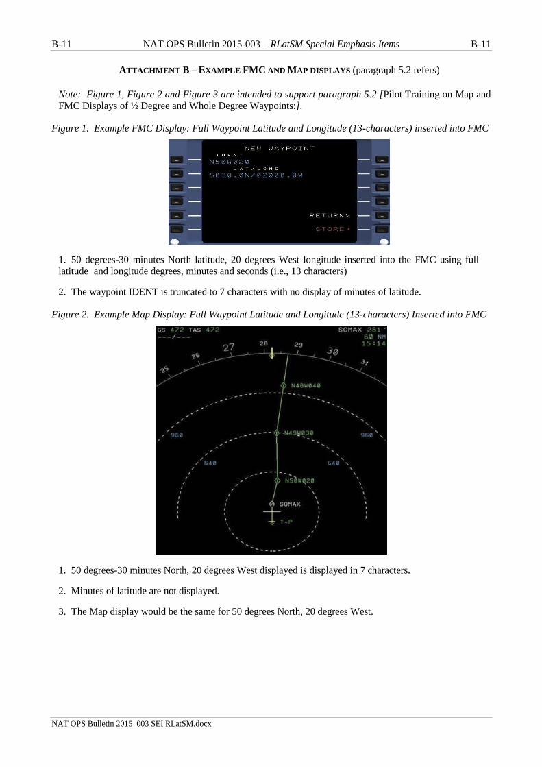
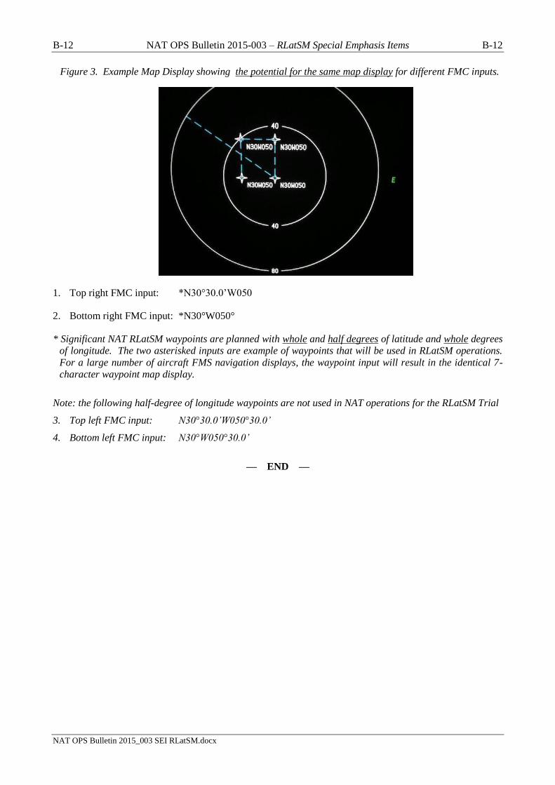
ATTACHMENT B – EXAMPLE FMC AND MAP DISPLAYS (paragraph 5.2 refers)
Note: Figure 1, Figure 2 and Figure 3 are intended to support paragraph 5.2 [Pilot Training on Map and
FMC Displays of ½ Degree and Whole Degree Waypoints:].
Figure 1. Example FMC Display: Full Waypoint Latitude and Longitude (13-characters) inserted into FMC
1. 50 degrees-30 minutes North latitude, 20 degrees West longitude inserted into the FMC using full
latitude and longitude degrees, minutes and seconds (i.e., 13 characters)
2. The waypoint IDENT is truncated to 7 characters with no display of minutes of latitude.
Figure 2. Example Map Display: Full Waypoint Latitude and Longitude (13-characters) Inserted into FMC
1. 50 degrees-30 minutes North, 20 degrees West displayed is displayed in 7 characters.
2. Minutes of latitude are not displayed.
3. The Map display would be the same for 50 degrees North, 20 degrees West.
B-12 NAT OPS Bulletin 2015-003 – RLatSM Special Emphasis Items B-12
NAT OPS Bulletin 2015_003 SEI RLatSM.docx
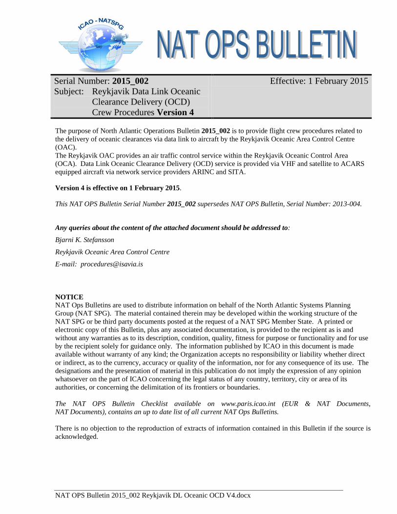
Figure 3. Example Map Display showing the potential for the same map display for different FMC inputs.
1. Top right FMC input: *N30°30.0’W050
2. Bottom right FMC input: *N30°W050°
* Significant NAT RLatSM waypoints are planned with whole and half degrees of latitude and whole degrees
of longitude. The two asterisked inputs are example of waypoints that will be used in RLatSM operations.
For a large number of aircraft FMS navigation displays, the waypoint input will result in the identical 7-
character waypoint map display.
Note: the following half-degree of longitude waypoints are not used in NAT operations for the RLatSM Trial
3. Top left FMC input: N30°30.0’W050°30.0’
4. Bottom left FMC input: N30°W050°30.0’
— END —
NAT OPS Bulletin 2015_002 Reykjavik DL Oceanic OCD V4.docx
Serial Number: 2015_002
Subject: Reykjavik Data Link Oceanic
Clearance Delivery (OCD)
Crew Procedures Version 4
Effective: 1 February 2015
The purpose of North Atlantic Operations Bulletin 2015_002 is to provide flight crew procedures related to
the delivery of oceanic clearances via data link to aircraft by the Reykjavik Oceanic Area Control Centre
(OAC).
The Reykjavik OAC provides an air traffic control service within the Reykjavik Oceanic Control Area
(OCA). Data Link Oceanic Clearance Delivery (OCD) service is provided via VHF and satellite to ACARS
equipped aircraft via network service providers ARINC and SITA.
Version 4 is effective on 1 February 2015.
This NAT OPS Bulletin Serial Number 2015_002 supersedes NAT OPS Bulletin, Serial Number: 2013-004.
Any queries about the content of the attached document should be addressed to:
Bjarni K. Stefansson
Reykjavik Oceanic Area Control Centre
E-mail: [email protected]
NOTICE NAT Ops Bulletins are used to distribute information on behalf of the North Atlantic Systems Planning
Group (NAT SPG). The material contained therein may be developed within the working structure of the
NAT SPG or be third party documents posted at the request of a NAT SPG Member State. A printed or
electronic copy of this Bulletin, plus any associated documentation, is provided to the recipient as is and
without any warranties as to its description, condition, quality, fitness for purpose or functionality and for use
by the recipient solely for guidance only. The information published by ICAO in this document is made
available without warranty of any kind; the Organization accepts no responsibility or liability whether direct
or indirect, as to the currency, accuracy or quality of the information, nor for any consequence of its use. The
designations and the presentation of material in this publication do not imply the expression of any opinion
whatsoever on the part of ICAO concerning the legal status of any country, territory, city or area of its
authorities, or concerning the delimitation of its frontiers or boundaries.
The NAT OPS Bulletin Checklist available on www.paris.icao.int (EUR & NAT Documents,
NAT Documents), contains an up to date list of all current NAT Ops Bulletins.
There is no objection to the reproduction of extracts of information contained in this Bulletin if the source is
acknowledged.

Reykjavik Data Link OCD Version 4 Page 2 of 13
Crew Procedures Effective 1 February 2015
REYKJAVIK DATA LINK
OCEANIC CLEARANCE DELIVERY (OCD)
CREW PROCEDURES
Reykjavik Oceanic Area Control Centre Operations Building
Reykjavik Data Link OCD Version 4 Page 3 of 13
Crew Procedures Effective 1 February 2015
1. Contents
Contents ................................................................................................................................................... 3 Summary of Changes .............................................................................................................................. 4 Abbreviations .......................................................................................................................................... 4 1. Introduction ..................................................................................................................................... 5 2. Requesting Clearance ...................................................................................................................... 6 3. Clearance Delivery .......................................................................................................................... 7 4. Clearance Acknowledgement .......................................................................................................... 8 5. Clearance Negotiation ..................................................................................................................... 8 6. Reclearances .................................................................................................................................... 9 7. Time Revisions ................................................................................................................................ 9 8. RCL and CLA Errors ...................................................................................................................... 9 9. Terms Used in the ATC/ Line ....................................................................................................... 11 10. Explanation of Data Link Clearance Elements ......................................................................... 12
Any Queries relating to this document should be addressed to:
Bjarni K. Stefansson
Reykjavik Oceanic Area Control Centre
e-mail: [email protected]
Reykjavik Data Link OCD Version 4 Page 4 of 13
Crew Procedures Effective 1 February 2015
2. Summary of Changes
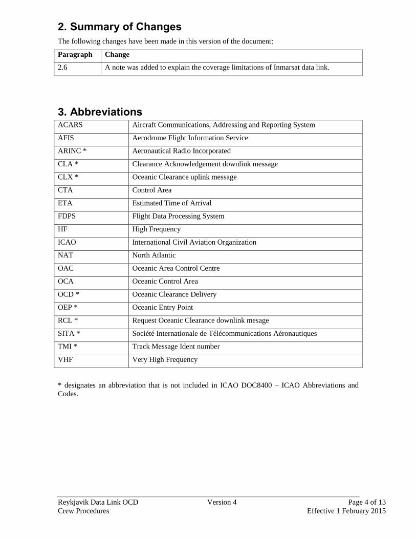
The following changes have been made in this version of the document:
Paragraph Change
2.6 A note was added to explain the coverage limitations of Inmarsat data link.
3. Abbreviations ACARS Aircraft Communications, Addressing and Reporting System
AFIS Aerodrome Flight Information Service
ARINC * Aeronautical Radio Incorporated
CLA * Clearance Acknowledgement downlink message
CLX * Oceanic Clearance uplink message
CTA Control Area
ETA Estimated Time of Arrival
FDPS Flight Data Processing System
HF High Frequency
ICAO International Civil Aviation Organization
NAT North Atlantic
OAC Oceanic Area Control Centre
OCA Oceanic Control Area
OCD * Oceanic Clearance Delivery
OEP * Oceanic Entry Point
RCL * Request Oceanic Clearance downlink mesage
SITA * Société Internationale de Télécommunications Aéronautiques
TMI * Track Message Ident number
VHF Very High Frequency
* designates an abbreviation that is not included in ICAO DOC8400 – ICAO Abbreviations and
Codes.
Reykjavik Data Link OCD Version 4 Page 5 of 13
Crew Procedures Effective 1 February 2015
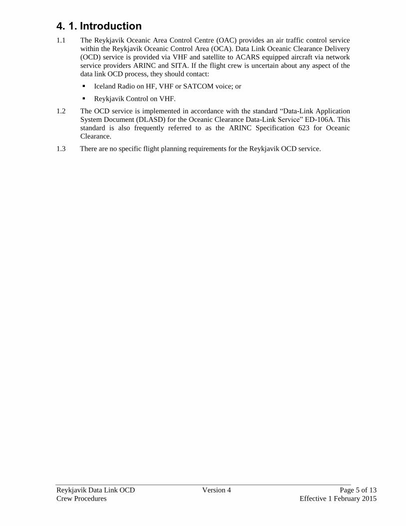
4. 1. Introduction
1.1 The Reykjavik Oceanic Area Control Centre (OAC) provides an air traffic control service
within the Reykjavik Oceanic Control Area (OCA). Data Link Oceanic Clearance Delivery
(OCD) service is provided via VHF and satellite to ACARS equipped aircraft via network
service providers ARINC and SITA. If the flight crew is uncertain about any aspect of the
data link OCD process, they should contact:
Iceland Radio on HF, VHF or SATCOM voice; or
Reykjavik Control on VHF.
1.2 The OCD service is implemented in accordance with the standard “Data-Link Application
System Document (DLASD) for the Oceanic Clearance Data-Link Service” ED-106A. This
standard is also frequently referred to as the ARINC Specification 623 for Oceanic
Clearance.
1.3 There are no specific flight planning requirements for the Reykjavik OCD service.

Reykjavik Data Link OCD Version 4 Page 6 of 13
Crew Procedures Effective 1 February 2015
5. 2. Requesting Clearance
2.1 Each operator of flights that can downlink RCL and CLA messages should ensure that
flight crews know how to address them to the Reykjavik OCD system.
2.2 The OCD transaction is initiated in all cases by a downlink oceanic clearance request
(RCL).
2.3 Any RCL must contain the following information, as a minimum:
Reykjavik Entry Point.
ETA for Entry Point.
Requested Mach Number.
Requested Flight Level.
Note: If the flight planned route does not contain a waypoint on the Reykjavik CTA
boundary then the Entry Point should be the next flight plan waypoint before the
Reykjavik CTA boundary. In such cases the entry point in the CLX message will be
a system calculated boundary crossing point and this change will be highlighted
with the text “ENTRY POINT CHANGE <position>” in the ATC/ line. Exceptions
to this are the waypoints EPMAN, DARUB, JULET and LT.
2.4 Crews may add remarks (RMK/) indicating the preferred alternative to the requested
clearance and maximum flight level that can be accepted at the Entry Point. Inclusion of
this information can assist the Reykjavik Controller and may expedite the clearance
delivery process.
2.5 The call sign in the RCL must match the aircraft identification as contained in the ICAO
flight plan, or the RCL will be rejected (see Section 8 – RCL and CLA Errors).
2.6 Reykjavik cannot issue oceanic clearances until coordination data has been received from
the adjacent air traffic control centre and the flight data has been activated within the
Reykjavik Flight Data Processing System (FDPS). This occurs a certain time before the
aircraft is estimated to enter the Reykjavik CTA and the time interval varies depending on
the control area from which the aircraft enters the Reykjavik CTA. The following can be
used as guidelines for the crew to determine when the RCL message can be accepted by the
Reykjavik FDPS:
Aircraft entering the Reykjavik CTA from
the following CTA
Send the RCL when the aircraft is less than
this many minutes from the Reykjavik CTA
Entry Point
Stavanger 25 minutes
Scottish 25 minutes
Edmonton 45 minutes (see note below)
Murmansk 30 minutes (see note below)
Rule of thumb:
Send RCL when 20-25 minutes from the Entry Point.
Note: Due to coverage limitations, aircraft equipped with Inmarsat data link cannot expect
to be able to obtain an oceanic clearance via data link when north of 82°N. Aircraft
that are equipped with Iridium and/or HF data link are not bound by the same
coverage limitations and should be able to obtain an oceanic clearance via data link
regardless of location.
Reykjavik Data Link OCD Version 4 Page 7 of 13
Crew Procedures Effective 1 February 2015
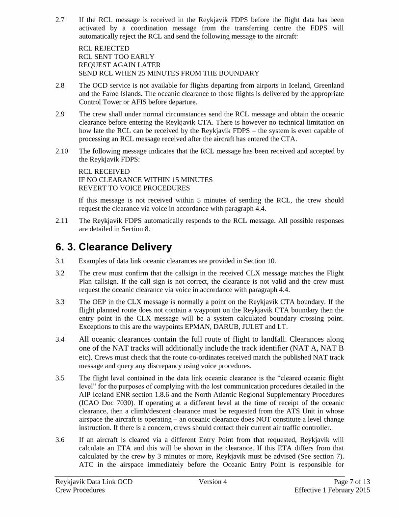
2.7 If the RCL message is received in the Reykjavik FDPS before the flight data has been
activated by a coordination message from the transferring centre the FDPS will
automatically reject the RCL and send the following message to the aircraft:
RCL REJECTED
RCL SENT TOO EARLY
REQUEST AGAIN LATER
SEND RCL WHEN 25 MINUTES FROM THE BOUNDARY
2.8 The OCD service is not available for flights departing from airports in Iceland, Greenland
and the Faroe Islands. The oceanic clearance to those flights is delivered by the appropriate
Control Tower or AFIS before departure.
2.9 The crew shall under normal circumstances send the RCL message and obtain the oceanic
clearance before entering the Reykjavik CTA. There is however no technical limitation on
how late the RCL can be received by the Reykjavik FDPS – the system is even capable of
processing an RCL message received after the aircraft has entered the CTA.
2.10 The following message indicates that the RCL message has been received and accepted by
the Reykjavik FDPS:
RCL RECEIVED
IF NO CLEARANCE WITHIN 15 MINUTES
REVERT TO VOICE PROCEDURES
If this message is not received within 5 minutes of sending the RCL, the crew should
request the clearance via voice in accordance with paragraph 4.4.
2.11 The Reykjavik FDPS automatically responds to the RCL message. All possible responses
are detailed in Section 8.
6. 3. Clearance Delivery
3.1 Examples of data link oceanic clearances are provided in Section 10.
3.2 The crew must confirm that the callsign in the received CLX message matches the Flight
Plan callsign. If the call sign is not correct, the clearance is not valid and the crew must
request the oceanic clearance via voice in accordance with paragraph 4.4.
3.3 The OEP in the CLX message is normally a point on the Reykjavik CTA boundary. If the
flight planned route does not contain a waypoint on the Reykjavik CTA boundary then the
entry point in the CLX message will be a system calculated boundary crossing point.
Exceptions to this are the waypoints EPMAN, DARUB, JULET and LT.
3.4 All oceanic clearances contain the full route of flight to landfall. Clearances along
one of the NAT tracks will additionally include the track identifier (NAT A, NAT B
etc). Crews must check that the route co-ordinates received match the published NAT track
message and query any discrepancy using voice procedures.
3.5 The flight level contained in the data link oceanic clearance is the “cleared oceanic flight
level” for the purposes of complying with the lost communication procedures detailed in the
AIP Iceland ENR section 1.8.6 and the North Atlantic Regional Supplementary Procedures
(ICAO Doc 7030). If operating at a different level at the time of receipt of the oceanic
clearance, then a climb/descent clearance must be requested from the ATS Unit in whose
airspace the aircraft is operating – an oceanic clearance does NOT constitute a level change
instruction. If there is a concern, crews should contact their current air traffic controller.
3.6 If an aircraft is cleared via a different Entry Point from that requested, Reykjavik will
calculate an ETA and this will be shown in the clearance. If this ETA differs from that
calculated by the crew by 3 minutes or more, Reykjavik must be advised (See section 7).
ATC in the airspace immediately before the Oceanic Entry Point is responsible for

Reykjavik Data Link OCD Version 4 Page 8 of 13
Crew Procedures Effective 1 February 2015
providing a revised route clearance to enable the flight to reach the new Oceanic Entry
Point.
3.7 The CLX may contain additional information, prefixed with the text “ATC/”. ATC/
messages are detailed in Section 9.
3.8 All Clearance messages terminate with the phrase- END OF MESSAGE. If this text is not
present, then data has been lost during transmission and the clearance must be ignored.
Crews must revert to voice procedures in accordance with paragraph 4.4.
7. 4. Clearance Acknowledgement
4.1 When a data link oceanic clearance (CLX) is received the crew shall:
a) Send a Clearance Acknowledgement message (CLA); or
b) Send a new RCL message (refer to Section 5).
4.2 Upon receipt of a valid CLA message, the Reykjavik FDPS will uplink a Clearance
Confirmed message. This message indicates that the data link oceanic clearance process is
complete and that no further action is required by the crew to acknowledge or verify the
oceanic clearance. The clearance transaction is not complete until the confirmation
message is received.
CLA RECEIVED
CLEARANCE CONFIRMED
If this message is not received within 5 minutes of sending the CLA, then the data link
oceanic clearance must be verified via voice in accordance with paragraphs 4.4 and 4.5.
4.3 If a CLA error message is received, the data link oceanic clearance must be verified via
voice in accordance with paragraphs 4.4 and 4.5 (see also Section 8 – RCL and CLA
Errors).
4.4 If a data link oceanic clearance must be verified or requested via voice then contact:
Iceland Radio on HF, VHF or SATCOM voice; or
Reykjavik Control on VHF.
4.5 When verifying a data link oceanic clearance via voice the following information must be
provided:
ETA for the OEP;
The NAT track identifier (if operating on a NAT track);
The cleared oceanic route (if operating on a random route);
The cleared oceanic flight level (see paragraph 3.4); and
The cleared Mach number.
8. 5. Clearance Negotiation
5.1 When a data link oceanic clearance (CLX) is received, the crew may elect to send a new
RCL message if the clearance is not acceptable.
5.2 If a revised clearance is issued then the new CLXs will be annotated “RECLEARANCE 1”,
“RECLEARANCE 2” etc.
5.3 The reclearance with the highest reclearance number shall be acknowledged.

Reykjavik Data Link OCD Version 4 Page 9 of 13
Crew Procedures Effective 1 February 2015
9. 6. Reclearances
6.1 The Reykjavik FDPS does not accept a new RCL once a CLA message has been received.
Any subsequent request for a change to the oceanic clearance shall be made on voice to:
Iceland Radio on HF, VHF or SATCOM voice; or
Reykjavik Control on VHF.
10. 7. Time Revisions
7.1 If the data link oceanic clearance has been received, crews should advise the current
controller via voice if the ETA for the OEP changes by 3 minutes or more. This may result
in ATC providing a reclearance.
7.2 The OEP estimate used by ATC when producing the oceanic clearance is located next to the
OEP in the data link clearance message (see Section 10). This time should be used when
considering whether a time revision notification to ATC is necessary. Crews should be
aware that this time may not coincide with the OEP estimate they sent in the RCL.
11. 8. RCL and CLA Errors RCL Errors
Error Message Message Meaning and Crew Action
RCL REJECTED
ERROR IN MESSAGE
REVERT TO VOICE PROCEDURES
Meaning: An error has been detected in the RCL
received by the Reykjavik OCD system.
Crew action: The oceanic clearance must be
requested via voice (see paragraph 4.4).
RCL REJECTED
REGISTRATION DOES NOT MATCH
FLIGHT PLAN
REVERT TO VOICE PROCEDURES
Meaning: The aircraft registration in the RCL
does not match the registration in the flight plan
in the Reykjavik FDPS.
Crew action: The oceanic clearance must be
requested via voice (see paragraph 4.4).
RCL REJECTED
FLIGHT PLAN NOT HELD
REVERT TO VOICE PROCEDURES
Meaning: The Reykjavik FDPS does not have a
flight plan for the flight.
Crew action: Check that the correct callsign was
used. Amend and re-request.
OR
The oceanic clearance must be requested via
voice (see paragraph 4.4).
RCL REJECTED
MULTIPLE FLIGHT PLAN HELD
REVERT TO VOICE PROCEDURES
Meaning: The Reykjavik FDPS holds more than
one flight plan for flight.
Crew action: The oceanic clearance must be
requested via voice (see paragraph 4.4).
RCL REJECTED
CLEARANCE HAS BEEN SENT TO
ICELAND RADIO
REVERT TO VOICE PROCEDURES
CONTACT ICELAND RADIO FOR
CLEARANCE
Meaning: The clearance has already been sent to
Iceland Radio for delivery on voice.
Crew action: Contact Iceland Radio on voice for
the clearance (see paragraph 4.4).

Reykjavik Data Link OCD Version 4 Page 10 of 13
Crew Procedures Effective 1 February 2015
RCL REJECTED
REQUEST BEING PROCESSED
AWAIT TRANSACTION COMPLETION
Meaning: The crew has sent a new RCL while
the previous one is still being processed by the
Reykjavik FDPS.
Crew action: Await clearance issued on the
basis of the original RCL, then input new RCL
if required.
RCL REJECTED
INVALID FLIGHT PLAN STATUS
REVERT TO VOICE PROCEDURES
Meaning: The status of the flight plan in the
Reykjavik FDPS is not appropriate for
processing of an RCL message.
Crew action: The oceanic clearance must be
requested via voice (see paragraph 4.4).
RCL REJECTED
RCL SENT TOO EARLY
REQUEST AGAIN LATER
SEND RCL WHEN 25 MINUTES FROM THE
BOUNDARY
Meaning: The flight plan has not yet been
activated in the Reykjavik FDPS (see
paragraphs 2.6-2.7).
Crew action: Send the RCL when 25 minutes
from the Reykjavik CTA boundary.
RCL REJECTED
CLEARANCE CANCELLED
REVERT TO VOICE PROCEDURES
TRANSACTION TIMED OUT
Meaning: The transaction has timed out in the
Reykjavik FDPS.
Crew action: The oceanic clearance must be
requested via voice (see paragraph 4.4).
CLA Errors
Error Message Message Meaning and Crew Action
CLA REJECTED
CLEARANCE CANCELLED
REVERT TO VOICE PROCEDURES
Meaning: The CLA received by the Reykjavik
OCD system did not match the data link oceanic
clearance or an error has been detected in the
CLA.
Crew action: The data link oceanic clearance
received by the crew is not valid. The oceanic
clearance must be requested via voice (see
paragraph 4.4).
CLA REJECTED
REGISTRATION DOES NOT MATCH
FLIGHT PLAN
REVERT TO VOICE PROCEDURES
Meaning: The aircraft registration in the CLA
does not match the registration in the flight plan
in the Reykjavik FDPS.
Crew action: The oceanic clearance must be
requested via voice (see paragraph 4.4).
CLA REJECTED
CLEARANCE CANCELLED
REVERT TO VOICE PROCEDURES
TRANSACTION TIMED OUT
Meaning: The transaction has timed out in the
Reykjavik FDPS before the CLA was received.
Crew action: The oceanic clearance must be
requested via voice (see paragraph 4.4).

Reykjavik Data Link OCD Version 4 Page 11 of 13
Crew Procedures Effective 1 February 2015
12. 9. Terms Used in the ATC/ Line
LEVEL CHANGE The flight level in the clearance is different from the flight
level requested in the RCL message.
MACH CHANGE The speed in the clearance is different from the speed
requested in the RCL message.
ENTRY POINT CHANGE
<position>
The entry point in the clearance is different from the entry
point requested in the RCL message.
ROUTE AMENDMENT The route in the clearance is different from the route in the
flight plan.
CLEARANCE LIMIT The clearance limit in the clearance is different from the
destination in the flight plan.
Reykjavik Data Link OCD Version 4 Page 12 of 13
Crew Procedures Effective 1 February 2015
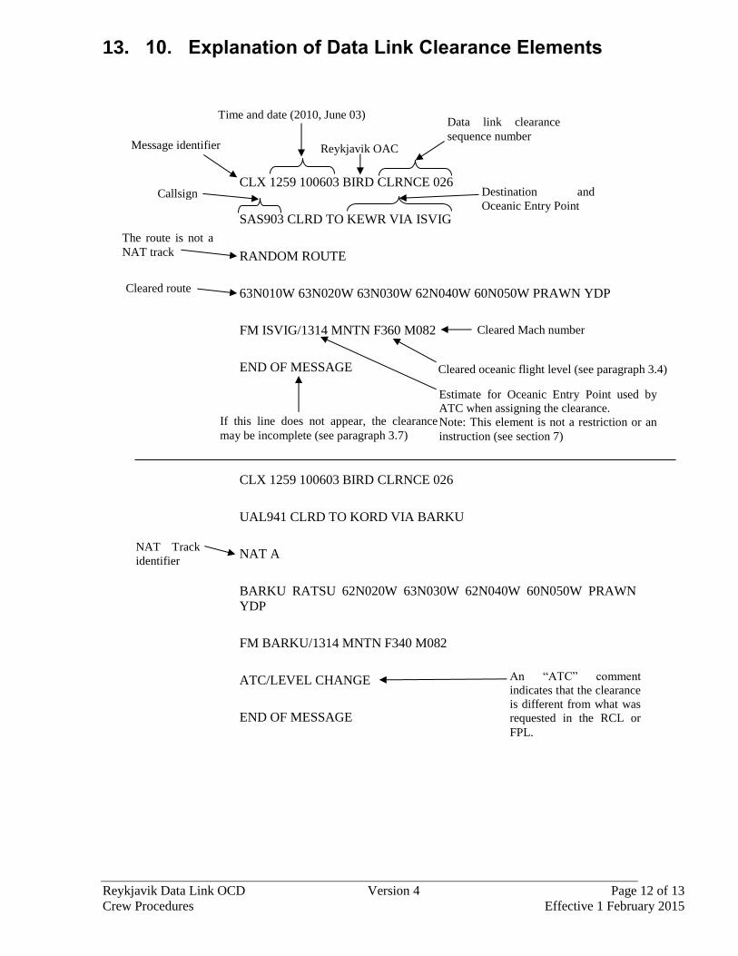
13. 10. Explanation of Data Link Clearance Elements
CLX 1259 100603 BIRD CLRNCE 026
SAS903 CLRD TO KEWR VIA ISVIG
RANDOM ROUTE
63N010W 63N020W 63N030W 62N040W 60N050W PRAWN YDP
FM ISVIG/1314 MNTN F360 M082
END OF MESSAGE
CLX 1259 100603 BIRD CLRNCE 026
UAL941 CLRD TO KORD VIA BARKU
NAT A
BARKU RATSU 62N020W 63N030W 62N040W 60N050W PRAWN
YDP
FM BARKU/1314 MNTN F340 M082
ATC/LEVEL CHANGE
END OF MESSAGE
Message identifier
The route is not a
NAT track
Time and date (2010, June 03)
Reykjavik OAC
Data link clearance
sequence number
Callsign Destination and
Oceanic Entry Point
Cleared route
An “ATC” comment
indicates that the clearance
is different from what was
requested in the RCL or
FPL.
Cleared Mach number
Cleared oceanic flight level (see paragraph 3.4)
If this line does not appear, the clearance
may be incomplete (see paragraph 3.7)
Estimate for Oceanic Entry Point used by
ATC when assigning the clearance.
Note: This element is not a restriction or an
instruction (see section 7)
NAT Track
identifier
Reykjavik Data Link OCD Version 4 Page 13 of 13
Crew Procedures Effective 1 February 2015
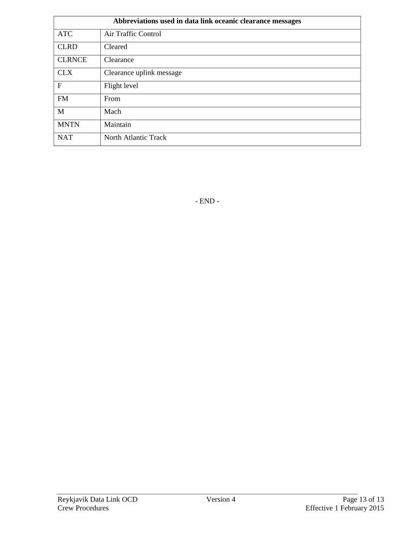
Abbreviations used in data link oceanic clearance messages
ATC Air Traffic Control
CLRD Cleared
CLRNCE Clearance
CLX Clearance uplink message
F Flight level
FM From
M Mach
MNTN Maintain
NAT North Atlantic Track
- END -
NAT OPS Bulletin 2015_001 Gander OCD CorrectedV23rev1.docx page 1 of 1
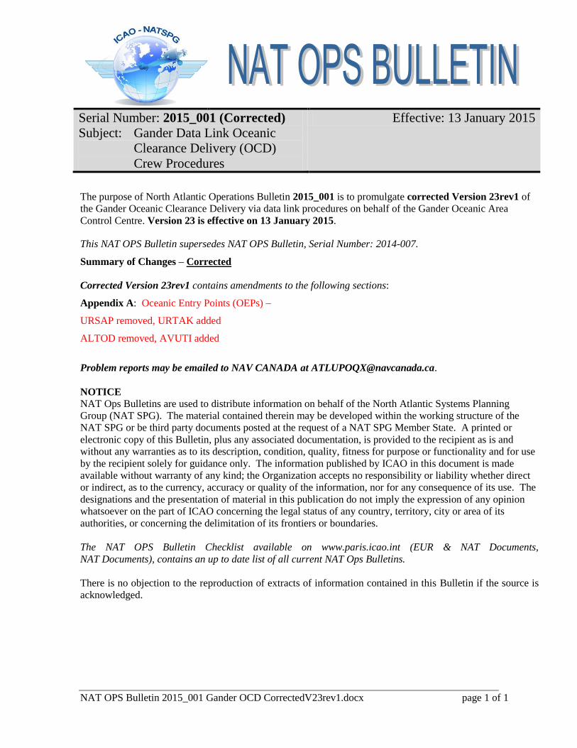
Serial Number: 2015_001 (Corrected)
Subject: Gander Data Link Oceanic
Clearance Delivery (OCD)
Crew Procedures
Effective: 13 January 2015
The purpose of North Atlantic Operations Bulletin 2015_001 is to promulgate corrected Version 23rev1 of
the Gander Oceanic Clearance Delivery via data link procedures on behalf of the Gander Oceanic Area
Control Centre. Version 23 is effective on 13 January 2015.
This NAT OPS Bulletin supersedes NAT OPS Bulletin, Serial Number: 2014-007.
Summary of Changes – Corrected
Corrected Version 23rev1 contains amendments to the following sections:
Appendix A: Oceanic Entry Points (OEPs) –
URSAP removed, URTAK added
ALTOD removed, AVUTI added
Problem reports may be emailed to NAV CANADA at [email protected].
NOTICE NAT Ops Bulletins are used to distribute information on behalf of the North Atlantic Systems Planning
Group (NAT SPG). The material contained therein may be developed within the working structure of the
NAT SPG or be third party documents posted at the request of a NAT SPG Member State. A printed or
electronic copy of this Bulletin, plus any associated documentation, is provided to the recipient as is and
without any warranties as to its description, condition, quality, fitness for purpose or functionality and for use
by the recipient solely for guidance only. The information published by ICAO in this document is made
available without warranty of any kind; the Organization accepts no responsibility or liability whether direct
or indirect, as to the currency, accuracy or quality of the information, nor for any consequence of its use. The
designations and the presentation of material in this publication do not imply the expression of any opinion
whatsoever on the part of ICAO concerning the legal status of any country, territory, city or area of its
authorities, or concerning the delimitation of its frontiers or boundaries.
The NAT OPS Bulletin Checklist available on www.paris.icao.int (EUR & NAT Documents,
NAT Documents), contains an up to date list of all current NAT Ops Bulletins.
There is no objection to the reproduction of extracts of information contained in this Bulletin if the source is
acknowledged.

Gander Data Link OCD Crew Procedures
Corrected Version 23-rev1
Page 1 of 12 13 Jan 2015
GANDER DATA LINK
OCEANIC CLEARANCE DELIVERY (OCD) CREW PROCEDURES
Gander Oceanic Area Control Centre Operations Building
Gander Data Link OCD Crew Procedures
Corrected Version 23-rev1
Page 2 of 12 13 Jan 2015
Contents Contents ...............................................................................................................2 Section 1 Summary of Changes ......................................................................3 Section 2 Introduction......................................................................................4 Section 3 Connecting to System .....................................................................4 Section 4 Requesting Clearance .....................................................................5 Section 5 Clearance Delivery ..........................................................................5 Section 6 Clearance Negotiation .....................................................................6 Section 7 Clearance Acknowledgement ..........................................................6 Section 8 Reclearances ..................................................................................7 Section 9 Time Revisions ................................................................................7 Section 10 RCL and CLA Errors........................................................................7 Appendix A – Oceanic Entry Points (OEPs) (north to south) ................................9 Appendix B – Terms Used in the ATC/ Line .........................................................9 Appendix C – Abbreviations..................................................................................9 Appendix D – Crew Check Lists...........................................................................10 Appendix E – Examples of Data Link Oceanic Clearances................................. 11

Gander Data Link OCD Crew Procedures
Corrected Version 23-rev1
Page 3 of 12 13 Jan 2015
Section 1 Summary of Changes Version 23 contains amendments to the following section: Appendix A: URSAP removed, URTAK added ALTOD removed, AVUTI added
Gander Data Link OCD Crew Procedures
Corrected Version 23-rev1
Page 4 of 12 13 Jan 2015
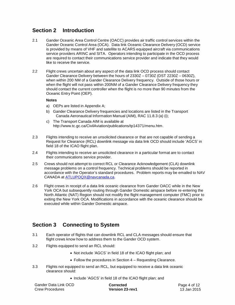
Section 2 Introduction 2.1 Gander Oceanic Area Control Centre (OACC) provides air traffic control services within the
Gander Oceanic Control Area (OCA). Data link Oceanic Clearance Delivery (OCD) service is provided by means of VHF and satellite to ACARS equipped aircraft via communications service providers ARINC and SITA. Operators intending to participate in the OCD process are required to contact their communications service provider and indicate that they would like to receive the service.
2.2 Flight crews uncertain about any aspect of the data link OCD process should contact
Gander Clearance Delivery between the hours of 2330Z – 0730Z (DST 2230Z – 0630Z), when within 200 NM of a Gander Clearance Delivery frequency. Outside of those hours or when the flight will not pass within 200NM of a Gander Clearance Delivery frequency they should contact the current controller when the flight is no more than 90 minutes from the Oceanic Entry Point (OEP).
Notes
a) OEPs are listed in Appendix A;
b) Gander Clearance Delivery frequencies and locations are listed in the Transport Canada Aeronautical Information Manual (AIM), RAC 11.8.3 (a) (i);
c) The Transport Canada AIM is available at http://www.tc.gc.ca/CivilAviation/publications/tp14371/menu.htm.
2.3 Flights intending to receive an unsolicited clearance or that are not capable of sending a Request for Clearance (RCL) downlink message via data link OCD should include ‘AGCS’ in field 18 of the ICAO flight plan.
2.4 Flights intending to receive an unsolicited clearance in a particular format are to contact their communications service provider.
2.5 Crews should not attempt to correct RCL or Clearance Acknowledgement (CLA) downlink message problems on a control frequency. Technical problems should be reported in accordance with the Operator’s standard procedures. Problem reports may be emailed to NAV CANADA at [email protected].
2.6 Flight crews in receipt of a data link oceanic clearance from Gander OACC while in the New
York OCA but subsequently routing through Gander Domestic airspace before re-entering the North Atlantic (NAT) Region should not modify the flight management computer (FMC) prior to exiting the New York OCA. Modifications in accordance with the oceanic clearance should be executed while within Gander Domestic airspace.
Section 3 Connecting to System 3.1 Each operator of flights that can downlink RCL and CLA messages should ensure that
flight crews know how to address them to the Gander OCD system.
3.2 Flights equipped to send an RCL should:
Not include ‘AGCS’ in field 18 of the ICAO flight plan; and
Follow the procedures in Section 4 – Requesting Clearance.
3.3 Flights not equipped to send an RCL, but equipped to receive a data link oceanic clearance should:
Include ‘AGCS’ in field 18 of the ICAO flight plan; and
Gander Data Link OCD Crew Procedures
Corrected Version 23-rev1
Page 5 of 12 13 Jan 2015
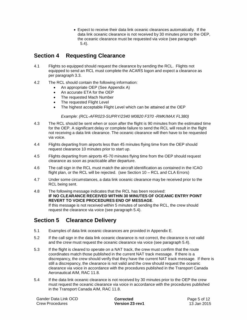
Expect to receive their data link oceanic clearances automatically. If the data link oceanic clearance is not received by 30 minutes prior to the OEP, the oceanic clearance must be requested via voice (see paragraph
5.4).
Section 4 Requesting Clearance 4.1 Flights so equipped should request the clearance by sending the RCL. Flights not
equipped to send an RCL must complete the ACARS logon and expect a clearance as per paragraph 3.3.
4.2 The RCL should contain the following information:
An appropriate OEP (See Appendix A)
An accurate ETA for the OEP
The requested Mach Number
The requested Flight Level
The highest acceptable Flight Level which can be attained at the OEP Example: (RCL-AFR023-SUPRY/2340 M0820 F370 -RMK/MAX FL380)
4.3 The RCL should be sent when or soon after the flight is 90 minutes from the estimated time for the OEP. A significant delay or complete failure to send the RCL will result in the flight not receiving a data link clearance. The oceanic clearance will then have to be requested via voice.
4.4 Flights departing from airports less than 45 minutes flying time from the OEP should request clearance 10 minutes prior to start up.
4.5 Flights departing from airports 45-70 minutes flying time from the OEP should request clearance as soon as practicable after departure.
4.6 The call sign in the RCL must match the aircraft identification as contained in the ICAO flight plan, or the RCL will be rejected. (see Section 10 – RCL and CLA Errors)
4.7 Under some circumstances, a data link oceanic clearance may be received prior to the RCL being sent.
4.8 The following message indicates that the RCL has been received: IF NO CLEARANCE RECEIVED WITHIN 30 MINUTES OF OCEANIC ENTRY POINT REVERT TO VOICE PROCEDURES END OF MESSAGE.
If this message is not received within 5 minutes of sending the RCL, the crew should request the clearance via voice (see paragraph 5.4).
Section 5 Clearance Delivery 5.1 Examples of data link oceanic clearances are provided in Appendix E.
5.2 If the call sign in the data link oceanic clearance is not correct, the clearance is not valid and the crew must request the oceanic clearance via voice (see paragraph 5.4).
5.3 If the flight is cleared to operate on a NAT track, the crew must confirm that the route coordinates match those published in the current NAT track message. If there is a discrepancy, the crew should verify that they have the current NAT track message. If there is still a discrepancy, the clearance is not valid and the crew should request the oceanic clearance via voice in accordance with the procedures published in the Transport Canada Aeronautical AIM, RAC 11.8.
5.4 If the data link oceanic clearance is not received by 30 minutes prior to the OEP the crew must request the oceanic clearance via voice in accordance with the procedures published in the Transport Canada AIM, RAC 11.8.

Gander Data Link OCD Crew Procedures
Corrected Version 23-rev1
Page 6 of 12 13 Jan 2015
5.5 The flight level contained in the data link oceanic clearance is the “cleared oceanic flight level” for the purposes of complying with the lost communication procedures detailed in the Transport Canada AIM, RAC 11.20, the Canada Flight Supplement and the North Atlantic Regional Supplementary Procedures (ICAO Doc 7030). ATC is responsible for providing a clearance to enable the flight to reach this flight level before reaching the OEP. If there is a concern, crews should contact their current controller.
5.6 The data link oceanic clearance may include a reroute to an oceanic entry point which is different from the current cleared route and/or may specify an oceanic entry point which is different from the flight plan. In all cases, flights should continue to operate in accordance with the current cleared route until a verbal reclearance is received from ATC.
5.7 If the clearance does not contain the line END OF MESSAGE, it is possible that the clearance was not complete. Crews must verify the clearance via voice (see paragraphs 7.4 and 7.5).
Section 6 Clearance Negotiation 6.1 Amendments to the data link oceanic clearance should be requested via voice. Flights
equipped to send an RCL should send one before requesting the amendment via voice.
6.2 Amendments to the data link oceanic clearance should be requested by contacting Gander Clearance Delivery between the hours of 2330Z – 0730Z (DST 2230Z – 0630Z), when within 200NM of a Gander Clearance Delivery frequency. Outside of those hours or when the flight will not pass within 200NM of a Gander Clearance Delivery frequency crews should contact the current controller when the flight is no more than 90 minutes from the OEP.
Section 7 Clearance Acknowledgement 7.1 When the data link oceanic clearance is received, flights equipped to send a Clearance
Acknowledgement (CLA) should do so. Flights not equipped to send a CLA must verify the data link oceanic clearance via voice in accordance with paragraphs 7.4 and 7.5.
7.2 The following message indicates that the data link oceanic clearance process is complete and that no further action is required by the crew to acknowledge or verify the oceanic clearance: CLA RECEIVED CLEARANCE CONFIRMED END OF MESSAGE.
If this message is not received within 5 minutes of sending the CLA, then the data link oceanic clearance must be verified via voice in accordance with paragraphs 7.4 and 7.5.
7.3 If a CLA error message is received, the data link oceanic clearance must be verified via voice in accordance with paragraphs 7.4 and 7.5. (see also Section 10 – RCL and CLA Errors)
7.4 If a data link oceanic clearance must be verified via voice, contact Gander Clearance Delivery between the hours of 2330Z – 0730Z (DST 2230Z – 0630Z), when within 200NM of a Gander Clearance Delivery frequency. Outside of those hours or when the flight will not pass within 200NM of a Gander Clearance Delivery frequency, crews should contact the current controller when the flight is no more than 90 minutes from the OEP.
7.5 When verifying a data link oceanic clearance via voice the following information must be provided:
ETA for the OEP;
The NAT track identifier (if operating on a NAT track);
The cleared oceanic route (if operating on a random route);
The cleared oceanic flight level (see paragraph 5.5); and
The cleared Mach number.

Gander Data Link OCD Crew Procedures
Corrected Version 23-rev1
Page 7 of 12 13 Jan 2015
Section 8 Reclearances 8.1 When a data link oceanic clearance is amended, it will include the ATC/ line and the
RECLEARANCE line (see Appendix E for examples of reclearances).
8.2 The ATC/ line will list which item (or items) of the clearance was changed from the previously issued clearance. The terms used in the ATC/ line are explained in Appendix B.
8.3 The RECLEARANCE line will contain a number from 1 to 9, to identify the first and subsequent reclearances.
8.4 The CLA should be sent for the clearance with the highest RECLEARANCE number.
8.5 If unable to send a CLA, the clearance should be verified via voice (see paragraphs 7.4 and 7.5).
8.6 If the reclearance does not contain the line END OF MESSAGE, it is possible that the clearance was incomplete. Crews must verify the clearance via voice (see paragraphs 7.4 and 7.5).
Section 9 Time Revisions 9.1 If the data link oceanic clearance has been received, crews should advise the current
controller via voice if the ETA for the OEP changes by 3 minutes or more. This may result in ATC providing a reclearance.
9.2 Crews should be aware that the time located next to the OEP in the data link clearance message (see Appendix E) is not a restriction or an instruction and may not coincide with the OEP estimate they sent in the RCL. This time should be used when considering whether a time revision notification to ATC is necessary.
Section 10 RCL and CLA Errors
RCL errors
RCL RECEIVED GANDER CLEARANCE NOT ACKNOWLEDGED SEND DATALINK ACCEPTANCE NOW
Meaning: There has been no CLA received in response to the data link oceanic clearance within the expected timeframe.
Crew Action: If no CLA has been sent, send it immediately. If a CLA has been sent then crew should operate in compliance with paragraph 7.2.
SERVICE NOT AVAILABLE REVERT TO VOICE PROCEDURES END OF MESSAGE
Meaning: The Gander OCD data link was not available when the RCL was sent.
Crew action: The oceanic clearance must be requested via voice (see paragraph 5.4).
RCL REJECTED ERROR IN MESSAGE REVERT TO VOICE PROCEDURES END OF MESSAGE
Meaning: There was a formatting error in the RCL received by the Gander OCD system.
Crew action: The oceanic clearance must be requested via voice (see paragraph 5.4).
RCL REJECTED CALLSIGN IN USE REVERT TO VOICE PROCEDURES END OF MESSAGE
Meaning: The call sign in the RCL matches a call sign associated with another aircraft.
Crew action: The oceanic clearance must be requested via voice (see paragraph 5.4).
Gander Data Link OCD Crew Procedures
Corrected Version 23-rev1
Page 8 of 12 13 Jan 2015
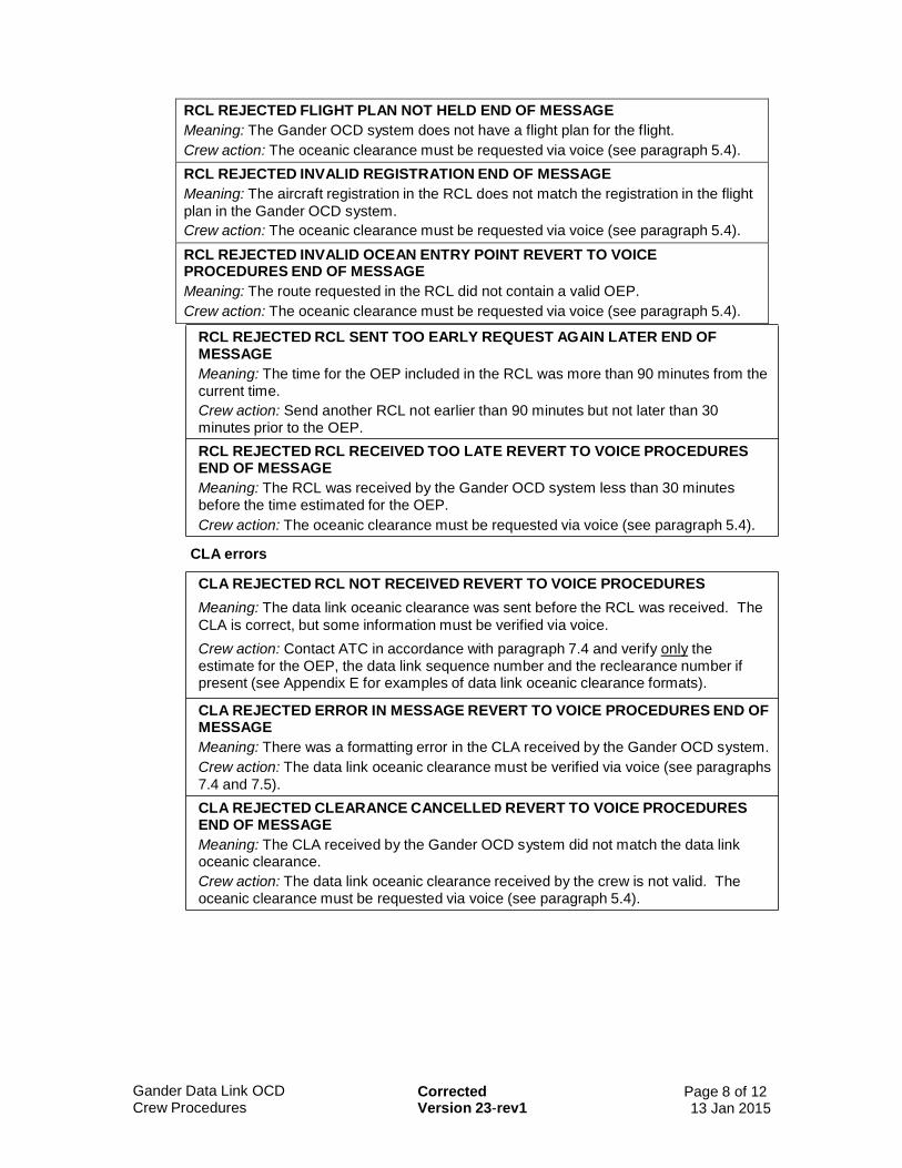
RCL REJECTED FLIGHT PLAN NOT HELD END OF MESSAGE
Meaning: The Gander OCD system does not have a flight plan for the flight.
Crew action: The oceanic clearance must be requested via voice (see paragraph 5.4).
RCL REJECTED INVALID REGISTRATION END OF MESSAGE
Meaning: The aircraft registration in the RCL does not match the registration in the flight
plan in the Gander OCD system.
Crew action: The oceanic clearance must be requested via voice (see paragraph 5.4).
RCL REJECTED INVALID OCEAN ENTRY POINT REVERT TO VOICE PROCEDURES END OF MESSAGE
Meaning: The route requested in the RCL did not contain a valid OEP.
Crew action: The oceanic clearance must be requested via voice (see paragraph 5.4).
RCL REJECTED RCL SENT TOO EARLY REQUEST AGAIN LATER END OF MESSAGE
Meaning: The time for the OEP included in the RCL was more than 90 minutes from the current time.
Crew action: Send another RCL not earlier than 90 minutes but not later than 30 minutes prior to the OEP.
RCL REJECTED RCL RECEIVED TOO LATE REVERT TO VOICE PROCEDURES END OF MESSAGE
Meaning: The RCL was received by the Gander OCD system less than 30 minutes before the time estimated for the OEP.
Crew action: The oceanic clearance must be requested via voice (see paragraph 5.4).
CLA errors
CLA REJECTED RCL NOT RECEIVED REVERT TO VOICE PROCEDURES
Meaning: The data link oceanic clearance was sent before the RCL was received. The
CLA is correct, but some information must be verified via voice.
Crew action: Contact ATC in accordance with paragraph 7.4 and verify only the estimate for the OEP, the data link sequence number and the reclearance number if present (see Appendix E for examples of data link oceanic clearance formats).
CLA REJECTED ERROR IN MESSAGE REVERT TO VOICE PROCEDURES END OF MESSAGE
Meaning: There was a formatting error in the CLA received by the Gander OCD system.
Crew action: The data link oceanic clearance must be verified via voice (see paragraphs
7.4 and 7.5).
CLA REJECTED CLEARANCE CANCELLED REVERT TO VOICE PROCEDURES END OF MESSAGE
Meaning: The CLA received by the Gander OCD system did not match the data link oceanic clearance.
Crew action: The data link oceanic clearance received by the crew is not valid. The oceanic clearance must be requested via voice (see paragraph 5.4).
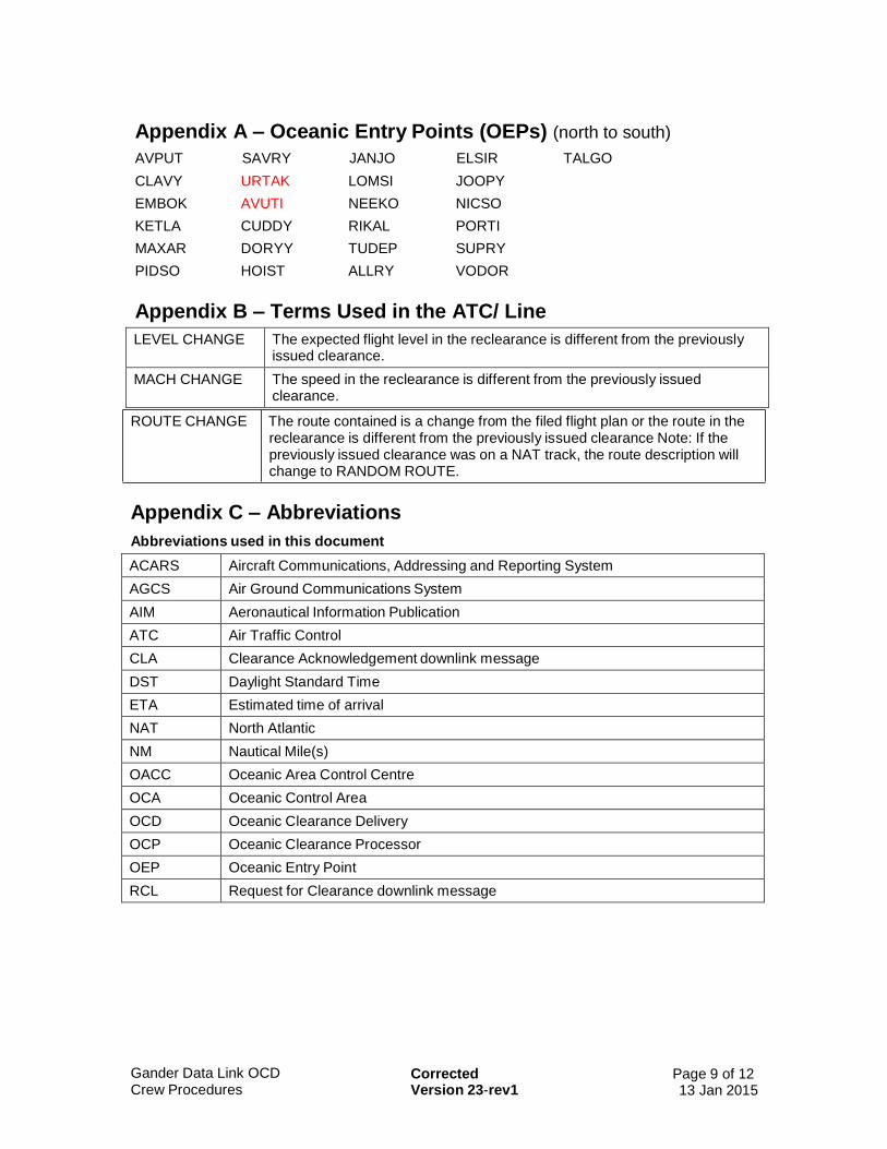
Gander Data Link OCD Crew Procedures
Corrected Version 23-rev1
Page 9 of 12 13 Jan 2015
Appendix A – Oceanic Entry Points (OEPs) (north to south)
AVPUT SAVRY JANJO ELSIR TALGO
CLAVY URTAK LOMSI JOOPY
EMBOK AVUTI NEEKO NICSO
KETLA CUDDY RIKAL PORTI
MAXAR DORYY TUDEP SUPRY
PIDSO HOIST ALLRY VODOR
Appendix B – Terms Used in the ATC/ Line
LEVEL CHANGE The expected flight level in the reclearance is different from the previously issued clearance.
MACH CHANGE The speed in the reclearance is different from the previously issued clearance.
ROUTE CHANGE The route contained is a change from the filed flight plan or the route in the reclearance is different from the previously issued clearance Note: If the previously issued clearance was on a NAT track, the route description will change to RANDOM ROUTE.
Appendix C – Abbreviations
Abbreviations used in this document
ACARS Aircraft Communications, Addressing and Reporting System
AGCS Air Ground Communications System
AIM Aeronautical Information Publication
ATC Air Traffic Control
CLA Clearance Acknowledgement downlink message
DST Daylight Standard Time
ETA Estimated time of arrival
NAT North Atlantic
NM Nautical Mile(s)
OACC Oceanic Area Control Centre
OCA Oceanic Control Area
OCD Oceanic Clearance Delivery
OCP Oceanic Clearance Processor
OEP Oceanic Entry Point
RCL Request for Clearance downlink message

Gander Data Link OCD Crew Procedures
Corrected Version 23-rev1
Page 10 of 12 13 Jan 2015
Abbreviations used in data link oceanic clearance messages
ATC Air Traffic Control
CLRD Cleared
CLRNCE Clearance sequence identifier
CLX Clearance uplink message identifier
F Flight Level
FM From
M Mach
NAT North Atlantic track
Appendix D – Crew Check Lists
Aircraft equipped to send an RCL:
1 Complete ACARS logon (see paragraph 3.1)
2 Send the RCL (see Section 4 – Requesting Clearance)
3 Ensure confirmation message is received (see paragraph 4.8)
4 If error message received, take appropriate action (see Section 10 – RCL and CLA Errors)
5 Receive data link oceanic clearance (see Section 5 – Clearance Delivery)
6 Confirm call sign in clearance matches the call sign in the flight plan (see paragraph 5.2)
7 Confirm that route coordinates are correct (see paragraph 5.3)
8 Send CLA (see paragraph 7.1)
9 Ensure confirmation message is received (see paragraph 7.2)
10 If error message received, take appropriate action (see Section 10 – RCL and CLA Errors)
11 Advise ATC via voice if the ETA for the OEP changes by 3 minutes or more (see Section 9 – Time Revisions).
Aircraft not equipped to send an RCL:
1 Complete ACARS logon (see paragraph 3.1)
2 Receive data link oceanic clearance (see Section 5 – Clearance Delivery)
3 Confirm call sign in clearance matches the call sign in the flight plan (see paragraph 5.2)
4 Confirm that route coordinates are correct (see paragraph 5.3)
5 If able, send CLA (see paragraph 7.1)
Ensure confirmation message is received (see paragraph 7.2)
If error message received, take appropriate action (see Section 10 – RCL and CLA Errors)
6 Verify clearance via voice (see paragraphs 7.4 and 7.5)
7 Advise ATC via voice if the ETA for the OEP changes by 3 minutes or more (see Section 9 – Time Revisions).
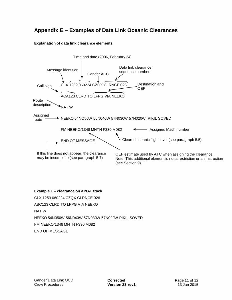
Gander Data Link OCD Crew Procedures
Corrected Version 23-rev1
Page 11 of 12 13 Jan 2015
Appendix E – Examples of Data Link Oceanic Clearances
Explanation of data link clearance elements
Time and date (2006, February 24)
Message identifier Gander ACC
Data link clearance sequence number
Call sign
Route description
CLX 1259 060224 CZQX CLRNCE 026
ACA123 CLRD TO LFPG VIA NEEKO
NAT W
Destination and OEP
Assigned route
NEEKO 54NO50W 56N040W 57N030W 57N020W PIKIL SOVED
FM NEEKO/1348 MNTN F330 M082
END OF MESSAGE
Assigned Mach number
Cleared oceanic flight level (see paragraph 5.5)
If this line does not appear, the clearance may be incomplete (see paragraph 5.7)
OEP estimate used by ATC when assigning the clearance. Note: This additional element is not a restriction or an instruction (see Section 9).
Example 1 – clearance on a NAT track
CLX 1259 060224 CZQX CLRNCE 026
ABC123 CLRD TO LFPG VIA NEEKO
NAT W
NEEKO 54N050W 56N040W 57N030W 57N020W PIKIL SOVED
FM NEEKO/1348 MNTN F330 M082
END OF MESSAGE

Gander Data Link OCD Crew Procedures
Corrected Version 23-rev1
Page 12 of 12 13 Jan 2015
Example 2 – clearance on a random route
CLX 1523 060530 CZQX CLRNCE 118
ABC456 CLRD TO EGLL VIA TUDEP
RANDOM ROUTE
TUDEP 52N050W 53N040W 53N030W 52N020W LIMRI DOLIP
FM TUDEP/1632 MNTN F350 M080
END OF MESSAGE
Example 3 – reclearance from the clearance in Example 1
CLX 1325 060224 CZQX CLRNCE 097
ABC123 CLRD TO LFPG VIA NEEKO
RANDOM ROUTE
NEEKO 54N050W 55N040W 56N030W 57N020W PIKIL SOVED
FM NEEKO/1430 MNTN F340 M082
ATC/ ROUTE CHANGE LEVEL CHANGE
RECLEARANCE 1
END OF MESSAGE
Example 4 – reclearance from the clearance in Example 2
CLX 1558 060530 CZQX CLRNCE 135
ABC456 CLRD TO EGLL VIA TUDEP
RANDOM ROUTE
TUDEP 52N050W 53N040W 53N030W 52N020W LIMRI DOLIP
FM TUDEP/1702 MNTN F350 M082
ATC/ MACH CHANGE
RECLEARANCE 1
END OF MESSAGE
Example 5 – reclearance from the clearance in Example 4
CLX 1605 060530 CZQX CLRNCE 149
ABC456 CLRD TO EGLL VIA TUDEP
RANDOM ROUTE
TUDEP 52N050W 52N040W 53N030W 52N020W LIMRI DOLIP
FM TUDEP/1711 MNTN F350 M082
ATC/ ROUTE CHANGE
RECLEARANCE 2
END OF MESSAGE

NAT OPS Bulletin 2014_006 Impl 50NM LatSep SantaMaria.docx
Serial Number: 2014_006
Subject: Implementation of 50NM Lateral
Separation in Santa Maria Oceanic CTA
Issued: 20 February 2014
The purpose of North Atlantic Operations Bulletin 2014_006 is to promulgate information on the
implementation of a 50NM Lateral Separation in Santa Maria oceanic CTA.
The purpose of this bulletin is to advise pilots and operators of the introduction of 50NM lateral separation
between RNAV10 (RNP10) and/or RNP4 approved aircraft in Santa Maria Oceanic CTA
For further Information, please contact:
Cirilo Araújo
Head of Air Traffic Services, Santa Maria FIR
NAV Portugal E.P.E
Phone: +351 296 820 504
E-mail: [email protected]
NOTICE NAT Ops Bulletins are used to distribute information on behalf of the North Atlantic Systems Planning
Group (NAT SPG). The material contained therein may be developed within the working structure of the
NAT SPG or be third party documents posted at the request of a NAT SPG Member State. A printed or
electronic copy of this Bulletin, plus any associated documentation, is provided to the recipient as is and
without any warranties as to its description, condition, quality, fitness for purpose or functionality and for use
by the recipient solely for guidance only. The information published by ICAO in this document is made
available without warranty of any kind; the Organization accepts no responsibility or liability whether direct
or indirect, as to the currency, accuracy or quality of the information, nor for any consequence of its use.
The designations and the presentation of material in this publication do not imply the expression of any
opinion whatsoever on the part of ICAO concerning the legal status of any country, territory, city or area of
its authorities, or concerning the delimitation of its frontiers or boundaries.
The NAT OPS Bulletin Checklist available on www.paris.icao.int (EUR & NAT Documents,
NAT Documents), contains an up to date list of all current NAT Ops Bulletins.
There is no objection to the reproduction of extracts of information contained in this Bulletin if the source is
acknowledged.
1.
AIP AIC: 003 - 2014 APublication Date: 06-Feb-2014
PORTUGAL
IMPLEMENTATION OF 50NM LATERAL SEPARATION IN SANTA MARIA OCEANIC CTA
Phone: +.351.21.855 35 06
Fax: +.351.21.855 33 99
AFS: LPPPYOYC
Email: [email protected]
DSEQSafety, Strategic and Quality
DirectorateAeronautical Information Service
Apartado 8223 1803-001 Lisboa Codex
1. IntroductionThe NAT Systems Planning Group (NAT SPG) is working on a plan for the transition from the NAT MNPS navigation specification to the ICAO PBN environment in conformance with the ICAO policies and guidance specified in the PBN Manual (Doc 9613) specifically the RNAV10 (RNP10) navigation specification. The NAT MNPS specification has been effective since 1976, in an area of applicability within most of the NAT Region covering the whole Santa Maria Oceanic CTA between F290 and F410 where lateral separation has been 60NM or 1 degree latitude.
In accordance with the ICAO PANS ATM Doc 4444, the standard lateral separation between any combination of RNAV10 (RNP10) and/or RNP4 certified aircraft flying parallel or non-intersecting tracks is 50NM which is already implemented in many areas across the world, inclusive adjacent airspace sharing extensive boundaries to Santa Maria Oceanic CTA.
A survey indicated that more than 96% of the aircraft operating in Santa Maria CTA is certified RNAV10 (RNP10) and/or RNP4. The introduction of 50NM standard lateral separation in Santa Maria Oceanic CTA is an initiative not only to progress towards the NAT goal of implementing PBN, but also for alignment with adjacent airspace as well as to increase airspace efficiency.
2. Purpose of CircularThe purpose of this circular is to advise pilots and operators of the introduction of 50NM lateral separation between RNAV10 (RNP10) and/or RNP4 approved aircraft in Santa Maria Oceanic CTA.
3. Area of applicabilitySanta Maria Oceanic CTA provided that a portion of the route is within, above or below MNPS vertical boundaries.
4. Aircraft eligibility
Aircraft must be approved RNAV10 (RNP10) and/or RNP4 to be eligible for 50NM lateral separation.
Note. – The ICAO Performance-based Navigation (PBN) Manual (Doc 9613) provides guidance on aircraft approval, operations and maintenance programs for initial achievement and continued compliance with RNAV10 (Designated and Authorized as RNP10) and RNP4.
5. Deterioration of aircraft navigation capabilities
Crews must advise ATC of any deterioration or failure of the navigation equipment that cause navigation performance to fall below RNAV10 (RNP10) required level.
2.
6. Provisions for accommodating non-eligible aircraft
There are no restrictions for accommodating aircraft that are not eligible for 50NM lateral separation in Santa Maria Oceanic CTA, thus not approved RNAV10 (RNP10) and/or RNP4. The 60NM standard separation minimum will be applied between these aircraft and other aircraft as long as MNPS approved.
7. Flight planning requirements
All procedures and guidance set forth in both NAT SUPPS (Doc 7030) and NAT MNPS Operations and Airspace Manual (NAT Doc 007) should continue to be taken into account.
When planning to operate with an approved MNPS aircraft in Santa Maria Oceanic CTA MNPS airspace, in addition to letter “X” filed in item 10 of the flight plan, to inform that an aircraft is approved RNAV10 (RNP10) and/or RNP4 and eligible for the application 50NM lateral separation, operators must comply with the flight planning requirements established in PANS ATM Doc ICAO 4444:
• Indicate in item 10 the letter:• R for RNP specification
• Indicate in item 18:
• PBN/A1 (RNAV10 /RNP10) and/or• PBN/L1 (RNP4)
8. Effective date
The application of 50NM lateral separation in Santa Maria CTA will commence on March 6th 2014.
9. Points of contact
For further information, please contact:
Cirilo AraújoHead of Air Traffic Services, Santa Maria FIRNAV Portugal E.P.E.Phone: +351 296 820 504Email: [email protected]
=END=
Serial Number: 2014_005
Subject: Automatic Dependent
Surveillance-Broadcast (ADS-B)
Issued:18 February 2014
The purpose of North Atlantic Operations Bulletin 2014_005 is to promulgate information concerning
Automatic Dependent Surveillance-Broadcast (ADS-B) within the Gander OCA on behalf of NAV
CANADA, the air navigation services provider for Canada.
This NAT OPS Bulletin supersedes NAT OPS Bulletin, Serial Number: 2012-022
This information was promulgated by Canada as AIC 29/13.
For question concerning AIC 29/13, please contact:
Doug Dillon
Manager, ACC Operations, Gander Area Control Centre
NAV CANADA
P.O. Box 328
Gander, NL A1V-1W7
Direct line: 709-651-5223
E-mail: [email protected]
NOTICE NAT Ops Bulletins are used to distribute information on behalf of the North Atlantic Systems Planning
Group (NAT SPG). The material contained therein may be developed within the working structure of the
NAT SPG or be third party documents posted at the request of a NAT SPG Member State. A printed or
electronic copy of this Bulletin, plus any associated documentation, is provided to the recipient as is and
without any warranties as to its description, condition, quality, fitness for purpose or functionality and for use
by the recipient solely for guidance only. The information published by ICAO in this document is made
available without warranty of any kind; the Organization accepts no responsibility or liability whether direct
or indirect, as to the currency, accuracy or quality of the information, nor for any consequence of its use.
The designations and the presentation of material in this publication do not imply the expression of any
opinion whatsoever on the part of ICAO concerning the legal status of any country, territory, city or area of
its authorities, or concerning the delimitation of its frontiers or boundaries.
The NAT OPS Bulletin Checklist available on www.paris.icao.int (EUR & NAT Documents,
NAT Documents), contains an up to date list of all current NAT Ops Bulletins.
There is no objection to the reproduction of extracts of information contained in this Bulletin if the source is
acknowledged.

AERONAUTICAL INFORMATION CIRCULAR 29/13
AUTOMATIC DEPENDENT SURVEILLANCE—BROADCAST SERVICE IN THE GANDER OCEANIC CONTROL AREA
(supersedes AIC 44/11) Introduction
Beginning February 2012, Gander area control centre (ACC) has been providing Automatic Dependent Surveillance–Broadcast (ADS-B) service to eligible aircraft operating within the southern Greenland portion of the Gander oceanic control area (OCA) (see map below). This aeronautical information circular (AIC) supplements information contained in AIC 31/11 regarding NAV CANADA ADS-B planning and services.
Yellow area: existing combined radar and ADS-B coverage
Red area: ADS-B coverage over southern Greenland
Note: Cette information est aussi disponible dans l’autre langue officielle.

Operational Use of ADS-B over Southern Greenland
The application of five-mile separation has been approved for use between ADS-B aircraft. However, the provision of effective air traffic services (ATS) surveillance services requires identification of the vast majority of aircraft operating within the airspace to ensure that the separation standard is maintained while other services are being provided. Although the number of eligible ADS-B aircraft has been steadily increasing since NAV CANADA initiated continental ADS-B services in 2009, the overall percentage of eligible aircraft operating within the North Atlantic (NAT) region is not yet sufficient to allow air traffic control (ATC) to provide a full range of surveillance services. Therefore, and until such time that the percentage of eligible aircraft increases to the point where additional services can be feasibly offered, ADS-B service over southern Greenland will be used primarily to aid in the provision of optimum vertical profiles to eligible aircraft.
With the commencement of service in February 2012 ADS-B has been used to provide flight level changes over southern Greenland in scenarios where the availability of ADS-B permits identified aircraft to climb or descend though the flight level of other ADS-B equipped aircraft. As of April 2013, Gander ACC has been able to consider flight level requests which would result in eligible aircraft operating with in-trail spacing of ten nautical miles.
Flight Crew and ATC Procedures
Because of the combination of eligible and non-eligible aircraft operating, all aircraft intending to transit the southern Greenland portion of the Gander OCA are expected to continue to flight plan in accordance with procedures outlined in NAT Doc 007, North Atlantic Operations and Airspace Manual, published by the International Civil Aviation Organization (ICAO). As always, flight crews are encouraged to request any changes, including flight level, to optimize the flight profile.
Where it is determined, following a request from the flight crew, that a flight level change can be attained because of the availability of ADS-B, the following steps can be expected:
• A very high frequency (VHF) control frequency will be assigned to the required flights by
ATC, either directly via controller-pilot data link communications (CPDLC) or via high frequency (HF) voice through the Gander international flight service station (IFSS) (Gander Radio).
• Once VHF contact has been established, the flights involved will be informed by ATC that identification has been established.
• The requested climb or descent clearance will be issued by ATC either via CPDLC or through the assigned VHF control frequency.
For climb and descend through scenarios, after the flight level change has been completed and vertical separation re-established, flight crews will normally be informed by ATC that surveillance services are terminated and subsequently returned to their previously assigned frequency.
Flight crews are advised that aircraft will not normally be informed of ADS-B identification unless a specific operational advantage, such as a flight level change, can be attained.
AERONAUTICAL INFORMATION CIRCULAR 29/13

Further Information
For further Information, please contact:
Doug Dillon, Manager ACC Operations, Gander Area Control Centre NAV CANADA P.O. Box 328 Gander, NL A1V 1W7
Direct line: 709-651-5223
E-mail: [email protected]
AERONAUTICAL INFORMATION CIRCULAR 29/13
NAT OPS Bulletin 2014_004 Trial RLatSM ICAONATReg.docx
Serial Number: 2014_004
Subject: Reduced Lateral Separation
Minimum (RLatSM)
Issued: 18 February 2014
The purpose of North Atlantic Operations Bulletin 2014_004 is to promulgate information on the
implementation of a 25NM RLatSM trial in the NAT Region.
For further Information, please contact:
Doug Dillon
Manager, ACC Operations, Gander Area Control Centre
NAV CANADA
P.O. Box 328
Gander, NL A1V-1W7
Direct line: 709-651-5223
E-mail: [email protected]
NOTICE NAT Ops Bulletins are used to distribute information on behalf of the North Atlantic Systems Planning
Group (NAT SPG). The material contained therein may be developed within the working structure of the
NAT SPG or be third party documents posted at the request of a NAT SPG Member State. A printed or
electronic copy of this Bulletin, plus any associated documentation, is provided to the recipient as is and
without any warranties as to its description, condition, quality, fitness for purpose or functionality and for use
by the recipient solely for guidance only. The information published by ICAO in this document is made
available without warranty of any kind; the Organization accepts no responsibility or liability whether direct
or indirect, as to the currency, accuracy or quality of the information, nor for any consequence of its use.
The designations and the presentation of material in this publication do not imply the expression of any
opinion whatsoever on the part of ICAO concerning the legal status of any country, territory, city or area of
its authorities, or concerning the delimitation of its frontiers or boundaries.
The NAT OPS Bulletin Checklist available on www.paris.icao.int (EUR & NAT Documents,
NAT Documents), contains an up to date list of all current NAT Ops Bulletins.
There is no objection to the reproduction of extracts of information contained in this Bulletin if the source is
acknowledged.
NAT OPS BULLETIN 2014_004 – Trial Implementation of RLatSM in the ICAO NAT Region
NAT OPS Bulletin 2014_004 Trial RLatSM ICAONATReg.docx
TRIAL IMPLEMENTATION OF RLATSM IN THE ICAO NAT REGION
INTRODUCTION OF A TRIAL OF A 25 NAUTICAL MILE REDUCED LATERAL SEPARATION
MINIMUM IN THE NORTH ATLANTIC REGION
Introduction
Advancements in aircraft avionics and air traffic management flight data processing systems have driven analysis of whether the lateral separation standard in the current North Atlantic (NAT) minimum navigation performance specification (MNPS) airspace can be reduced to increase the number of tracks available and therefore increase capacity at optimum flight levels.
On or soon after 5 February 2015, Gander, Shanwick and Reykjavik area control centres (ACCs) will commence participation in the trial of a 25 nautical mile (NM) reduced lateral separation minimum (RLatSM) in portions of the Gander, Shanwick and Reykjavik oceanic control areas (OCAs).
Background
Track spacing for MNPS approved aircraft is currently one degree of latitude, which equates nominally to 60 NM. The proposed change will reduce lateral separation for aircraft operating at the flight levels and tracks associated with the NAT Region Data Link Mandate (NAT SPG Conclusion 46/2 refers) airspace, which can be practically achieved by establishing tracks which are spaced by ½ degree of latitude. This track spacing initiative will be referred to as Reduced Lateral Separation Minimum (RLatSM).
RLatSM will be implemented using a phased approach, the first of which will introduce ½ degree spacing between the two core tracks of the NAT organized track structure (OTS) from FL350 to FL390 inclusive. At yet to be determined dates, Phase 2 will expand the implementation throughout the entire NAT OTS and Phase 3 will encompass the entire ICAO NAT Region, including for converging and intersecting track situations
Operator Eligibility and Participation
Operators do not need to apply to be part of the trial and will be eligible to flight plan RLatSM tracks provided the flights are:
a) MNPS approved
b) RNP4 approved
c) ADS-C and CPDLC equipped and, where applicable, authorized; and
d) the required CNS systems are operational.
Flight crews must report any failure or malfunction of GPS, ADS-C or CPDLC equipment to air traffic control (ATC) as soon as it becomes apparent.
Flight Planning
ATS systems use Field 10 (Equipment) and Field 18 (Other Information) of the standard ICAO flight plan to identify an aircraft’s data link and navigation capabilities. The operator should insert the following items into the ICAO flight plan for FANS 1/A or equivalent aircraft:
a) Field 10a (Radio communication, navigation and approach aid equipment and capabilities);
insert “J5” to indicate CPDLC FANS1/A SATCOM (Inmarsat) and/or “J7” to indicate CPDLC FANS1/A SATCOM (Iridium) data link equipment;and
NAT OPS BULLETIN 2014_004 – Trial Implementation of RLatSM in the ICAO NAT Region
NAT OPS Bulletin 2014_004 Trial RLatSM ICAONATReg.docx
insert “X” to indicate MNPS operational approval;
b) Field 10b (Surveillance equipment and capabilities);
insert “D1” to indicate ADS with FANS 1/A capabilities.
c) Field 18 (Other Information);
insert the characters “PBN/” followed by “L1” for RNP4.
Further Information
The current, updated versions of the Draft NAT RLatSM Plan and associated documents are provided on the ICAO EUR/NAT website (www.paris.icao.int), via the links to EUR & NAT Documents >> NAT Documents >> Planning documents supporting separation reductions, or via the following URL:
http://www.paris.icao.int/documents_open/files.php?subcategory_id=143
For further Information, please contact:
Doug Dillon, Manager ACC Operations, Gander Area Control Centre NAV CANADA P.O. Box 328 Gander, NL A1V 1W7
Direct line: 709-651-5223 E-mail: [email protected]
- END -
NAT OPS Bulletin 2014_003 Gander OCD V21.docx page 1 of 13
Serial Number: 2014_003
Subject: Gander Data Link Oceanic
Clearance Delivery (OCD)
Crew Procedures
Effective: 6 February 2014
The purpose of North Atlantic Operations Bulletin 2014_003 is to promulgate Version 21 of the Gander
Oceanic Clearance Delivery via data link procedures on behalf of the Gander Oceanic Area Control Centre.
Version 21 is effective on 6 February 2014.
This NAT OPS Bulletin supersedes NAT OPS Bulletin, Serial Number: 2012-028.
Crews should not attempt to correct RCL or Clearance Acknowledgement (CLA) downlink message
problems on a control frequency. Technical problems should be reported in accordance with the Operator’s
standard procedures. Problem reports may be emailed to NAV CANADA at [email protected].
NOTICE NAT Ops Bulletins are used to distribute information on behalf of the North Atlantic Systems Planning
Group (NAT SPG). The material contained therein may be developed within the working structure of the
NAT SPG or be third party documents posted at the request of a NAT SPG Member State. A printed or
electronic copy of this Bulletin, plus any associated documentation, is provided to the recipient as is and
without any warranties as to its description, condition, quality, fitness for purpose or functionality and for use
by the recipient solely for guidance only. The information published by ICAO in this document is made
available without warranty of any kind; the Organization accepts no responsibility or liability whether direct
or indirect, as to the currency, accuracy or quality of the information, nor for any consequence of its use. The
designations and the presentation of material in this publication do not imply the expression of any opinion
whatsoever on the part of ICAO concerning the legal status of any country, territory, city or area of its
authorities, or concerning the delimitation of its frontiers or boundaries.
The NAT OPS Bulletin Checklist available on www.paris.icao.int (EUR & NAT Documents,
NAT Documents), contains an up to date list of all current NAT Ops Bulletins.
There is no objection to the reproduction of extracts of information contained in this Bulletin if the source is
acknowledged.
There is no objection to the reproduction of extracts of information contained in this Bulletin if the source is
acknowledged.

NAT OPS Bulletin 2014_003 Gander OCD V21.docx page 1 of 13
GANDER DATA LINK
OCEANIC CLEARANCE DELIVERY (OCD) CREW PROCEDURES
Gander Oceanic Area Control Centre Operations Building
NAT OPS Bulletin 2014_003 Gander OCD V21.docx page 2 of 13
Contents Contents .................................................................................................................2 Section 1 Summary of Changes ......................................................................3 Section 2 Introduction......................................................................................4 Section 3 Connecting to System .....................................................................4 Section 4 Requesting Clearance .....................................................................5 Section 5 Clearance Delivery ..........................................................................5 Section 6 Clearance Negotiation .....................................................................6 Section 7 Clearance Acknowledgement ..........................................................6 Section 8 Reclearances ..................................................................................7 Section 9 Time Revisions ................................................................................7 Section 10 RCL and CLA Errors........................................................................7 Appendix A – Oceanic Entry Points (OEPs) (north to south) .................................9 Appendix B – Terms Used in the ATC/ Line ..........................................................9 Appendix C – Abbreviations...................................................................................9 Appendix D – Crew Check Lists...........................................................................10 Appendix E – Examples of Data Link Oceanic Clearances.................................. 11
NAT OPS Bulletin 2014_003 Gander OCD V21.docx page 3 of 13
Section 1 Summary of Changes Version 21 contains amendments to the following section:
Section 2 – Editorial changes to clarify the meaning of RCL (2.3) and CLA (2.5) - Change in procedure for receiving unsolicited clearances in a particular format (2.4) - New 2.6 proving instructions for flight crews in receipt of a data link oceanic clearance from Gander OACC while in the New York OCA Section 4 – New 4.2 added to specify required items in an RCL downlink message. Old 4.5 removed as redundant. Paragraphs renumbered to reflect above changes. Section 10 – New RCL Error, Meaning and Crew Action added Appendix C – Clarifications provided to meaning of abbreviations “CLRNCE” and “CLX” in the data link oceanic clearance message Appendix E – Examples updated to include current oceanic entry points
NAT OPS Bulletin 2014_003 Gander OCD V21.docx page 4 of 13
Section 2 Introduction 2.1 Gander Oceanic Area Control Centre (OACC) provides air traffic control services within the Gander Oceanic Control Area (OCA). Data link Oceanic Clearance Delivery (OCD) service is provided by means of VHF and satellite to ACARS equipped aircraft via communications service providers ARINC and SITA. Operators intending to participate in the OCD process are required to contact their communications service provider and indicate that they would like to receive the service. 2.2 Flight crews uncertain about any aspect of the data link OCD process should contact Gander Clearance Delivery between the hours of 2330Z – 0730Z (DST 2230Z – 0630Z), when within 200 NM of a Gander Clearance Delivery frequency. Outside of those hours or when the flight will not pass within 200NM of a Gander Clearance Delivery frequency they should contact the current controller when the flight is no more than 90 minutes from the Oceanic Entry Point (OEP).
Notes
a) OEPs are listed in Appendix A;
b) Gander Clearance Delivery frequencies and locations are listed in the Transport Canada Aeronautical Information Manual (AIM), RAC 11.8.3 (a) (i);
c) The Transport Canada AIM is available at http://www.tc.gc.ca/CivilAviation/publications/tp14371/menu.htm.
2.3 Flights intending to receive an unsolicited clearance or that are not capable of sending a Request for Clearance (RCL) downlink message via data link OCD should include ‘AGCS’ in field 18 of the ICAO flight plan.
2.4 Flights intending to receive an unsolicited clearance in a particular format are to contact their communications service provider.
2.5 Crews should not attempt to correct RCL or Clearance Acknowledgement (CLA) downlink message problems on a control frequency. Technical problems should be reported in accordance with the Operator’s standard procedures. Problem reports may be emailed to NAV CANADA at [email protected]. 2.6 Flight crews in receipt of a data link oceanic clearance from Gander OACC while in the New York OCA but subsequently routing through Gander Domestic airspace before re-entering the North Atlantic (NAT) Region should not modify the flight management computer (FMC) prior to exiting the New York OCA. Modifications in accordance with the oceanic clearance should be executed while within Gander Domestic airspace.
Section 3 Connecting to System 3.1 Each operator of flights that can downlink RCL and CLA messages should ensure that flight crews know how to address them to the Gander OCD system.
3.2 Flights equipped to send an RCL should:
Not include ‘AGCS’ in field 18 of the ICAO flight plan; and
Follow the procedures in Section 4 – Requesting Clearance.
3.3 Flights not equipped to send an RCL, but equipped to receive a data link oceanic clearance should:
Include ‘AGCS’ in field 18 of the ICAO flight plan; and
NAT OPS Bulletin 2014_003 Gander OCD V21.docx page 5 of 13
Expect to receive their data link oceanic clearances automatically. If the data link oceanic clearance is not received by 30 minutes prior to the OEP, the oceanic clearance must be requested via voice (see paragraph
5.4).
Section 4 Requesting Clearance 4.1 Flights so equipped should request the clearance by sending the RCL. Flights not equipped to send an RCL must complete the ACARS logon and expect a clearance as per paragraph 3.3.
4.2 The RCL should contain the following information:
An appropriate OEP (See Appendix A)
An accurate ETA for the OEP
The requested Mach Number
The requested Flight Level
The highest acceptable Flight Level which can be attained at the OEP Example: (RCL-AFR023-URTAK/2340 M0820 F370 -RMK/MAX FL380)
4.3 The RCL should be sent when or soon after the flight is 90 minutes from the estimated time for the OEP. A significant delay or complete failure to send the RCL will result in the flight not receiving a data link clearance. The oceanic clearance will then have to be requested via voice.
4.4 Flights departing from airports less than 45 minutes flying time from the OEP should request clearance 10 minutes prior to start up.
4.5 Flights departing from airports 45-70 minutes flying time from the OEP should request clearance as soon as practicable after departure.
4.6 The call sign in the RCL must match the aircraft identification as contained in the ICAO flight plan, or the RCL will be rejected. (see Section 10 – RCL and CLA Errors)
4.7 Under some circumstances, a data link oceanic clearance may be received prior to the RCL being sent.
4.8 The following message indicates that the RCL has been received: IF NO CLEARANCE RECEIVED WITHIN 30 MINUTES OF OCEANIC ENTRY POINT REVERT TO VOICE PROCEDURES END OF MESSAGE. If this message is not received within 5 minutes of sending the RCL, the crew should request the clearance via voice (see paragraph 5.4).
Section 5 Clearance Delivery 5.1 Examples of data link oceanic clearances are provided in Appendix E.
5.2 If the call sign in the data link oceanic clearance is not correct, the clearance is not valid and the crew must request the oceanic clearance via voice (see paragraph 5.4).
5.3 If the flight is cleared to operate on a NAT track, the crew must confirm that the route coordinates match those published in the current NAT track message. If there is a discrepancy, the crew should verify that they have the current NAT track message. If there is still a discrepancy, the clearance is not valid and the crew should request the oceanic clearance via voice in accordance with the procedures published in the Transport Canada Aeronautical AIM, RAC 11.8.
5.4 If the data link oceanic clearance is not received by 30 minutes prior to the OEP the crew must request the oceanic clearance via voice in accordance with the procedures published in the Transport Canada AIM, RAC 11.8.
5.5 The flight level contained in the data link oceanic clearance is the “cleared oceanic flight level” for the purposes of complying with the lost communication procedures detailed in the
NAT OPS Bulletin 2014_003 Gander OCD V21.docx page 6 of 13
Transport Canada AIM, RAC 11.20, the Canada Flight Supplement and the North Atlantic Regional Supplementary Procedures (ICAO Doc 7030). ATC is responsible for providing a clearance to enable the flight to reach this flight level before reaching the OEP. If there is a concern, crews should contact their current controller.
5.6 The data link oceanic clearance may include a reroute to an oceanic entry point which is different from the current cleared route and/or may specify an oceanic entry point which is different from the flight plan. In all cases, flights should continue to operate in accordance with the current cleared route until a verbal reclearance is received from ATC.
5.7 If the clearance does not contain the line END OF MESSAGE, it is possible that the clearance was not complete. Crews must verify the clearance via voice (see paragraphs 7.4 and 7.5).
Section 6 Clearance Negotiation 6.1 Amendments to the data link oceanic clearance should be requested via voice. Flights equipped to send an RCL should send one before requesting the amendment via voice.
6.2 Amendments to the data link oceanic clearance should be requested by contacting Gander Clearance Delivery between the hours of 2330Z – 0730Z (DST 2230Z – 0630Z), when within 200NM of a Gander Clearance Delivery frequency. Outside of those hours or when the flight will not pass within 200NM of a Gander Clearance Delivery frequency crews should contact the current controller when the flight is no more than 90 minutes from the OEP.
Section 7 Clearance Acknowledgement 7.1 When the data link oceanic clearance is received, flights equipped to send a Clearance Acknowledgement (CLA) should do so. Flights not equipped to send a CLA must verify the data link oceanic clearance via voice in accordance with paragraphs 7.4 and 7.5.
7.2 The following message indicates that the data link oceanic clearance process is complete and that no further action is required by the crew to acknowledge or verify the oceanic clearance: CLA RECEIVED CLEARANCE CONFIRMED END OF MESSAGE.
If this message is not received within 5 minutes of sending the CLA, then the data link oceanic clearance must be verified via voice in accordance with paragraphs 7.4 and 7.5.
7.3 If a CLA error message is received, the data link oceanic clearance must be verified via voice in accordance with paragraphs 7.4 and 7.5. (see also Section 10 – RCL and CLA Errors)
7.4 If a data link oceanic clearance must be verified via voice, contact Gander Clearance Delivery between the hours of 2330Z – 0730Z (DST 2230Z – 0630Z), when within 200NM of a Gander Clearance Delivery frequency. Outside of those hours or when the flight will not pass within 200NM of a Gander Clearance Delivery frequency, crews should contact the current controller when the flight is no more than 90 minutes from the OEP.
7.5 When verifying a data link oceanic clearance via voice the following information must be provided:
ETA for the OEP;
The NAT track identifier (if operating on a NAT track);
The cleared oceanic route (if operating on a random route);
The cleared oceanic flight level (see paragraph 5.5); and
The cleared Mach number.
Section 8 Reclearances 8.1 When a data link oceanic clearance is amended, it will include the ATC/ line and the
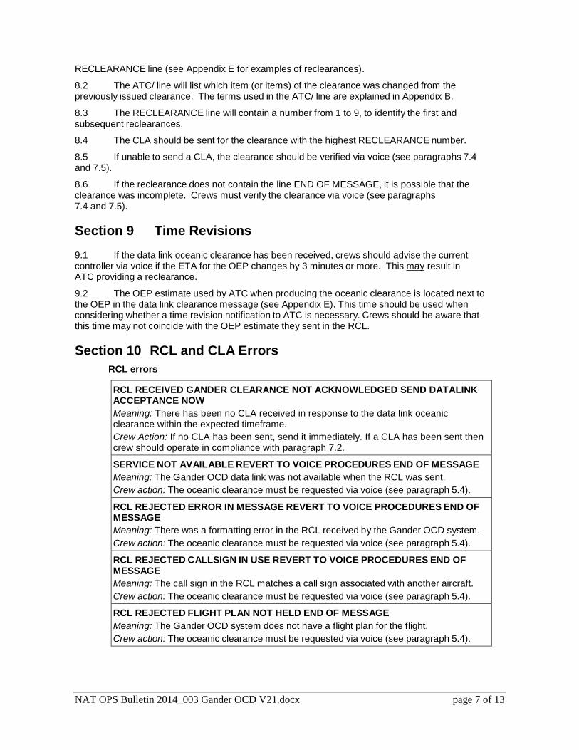
NAT OPS Bulletin 2014_003 Gander OCD V21.docx page 7 of 13
RECLEARANCE line (see Appendix E for examples of reclearances).
8.2 The ATC/ line will list which item (or items) of the clearance was changed from the previously issued clearance. The terms used in the ATC/ line are explained in Appendix B.
8.3 The RECLEARANCE line will contain a number from 1 to 9, to identify the first and subsequent reclearances.
8.4 The CLA should be sent for the clearance with the highest RECLEARANCE number.
8.5 If unable to send a CLA, the clearance should be verified via voice (see paragraphs 7.4 and 7.5).
8.6 If the reclearance does not contain the line END OF MESSAGE, it is possible that the clearance was incomplete. Crews must verify the clearance via voice (see paragraphs 7.4 and 7.5).
Section 9 Time Revisions 9.1 If the data link oceanic clearance has been received, crews should advise the current controller via voice if the ETA for the OEP changes by 3 minutes or more. This may result in ATC providing a reclearance.
9.2 The OEP estimate used by ATC when producing the oceanic clearance is located next to the OEP in the data link clearance message (see Appendix E). This time should be used when considering whether a time revision notification to ATC is necessary. Crews should be aware that this time may not coincide with the OEP estimate they sent in the RCL.
Section 10 RCL and CLA Errors
RCL errors
RCL RECEIVED GANDER CLEARANCE NOT ACKNOWLEDGED SEND DATALINK ACCEPTANCE NOW
Meaning: There has been no CLA received in response to the data link oceanic clearance within the expected timeframe.
Crew Action: If no CLA has been sent, send it immediately. If a CLA has been sent then crew should operate in compliance with paragraph 7.2.
SERVICE NOT AVAILABLE REVERT TO VOICE PROCEDURES END OF MESSAGE
Meaning: The Gander OCD data link was not available when the RCL was sent.
Crew action: The oceanic clearance must be requested via voice (see paragraph 5.4).
RCL REJECTED ERROR IN MESSAGE REVERT TO VOICE PROCEDURES END OF MESSAGE
Meaning: There was a formatting error in the RCL received by the Gander OCD system.
Crew action: The oceanic clearance must be requested via voice (see paragraph 5.4).
RCL REJECTED CALLSIGN IN USE REVERT TO VOICE PROCEDURES END OF MESSAGE
Meaning: The call sign in the RCL matches a call sign associated with another aircraft.
Crew action: The oceanic clearance must be requested via voice (see paragraph 5.4).
RCL REJECTED FLIGHT PLAN NOT HELD END OF MESSAGE
Meaning: The Gander OCD system does not have a flight plan for the flight.
Crew action: The oceanic clearance must be requested via voice (see paragraph 5.4).
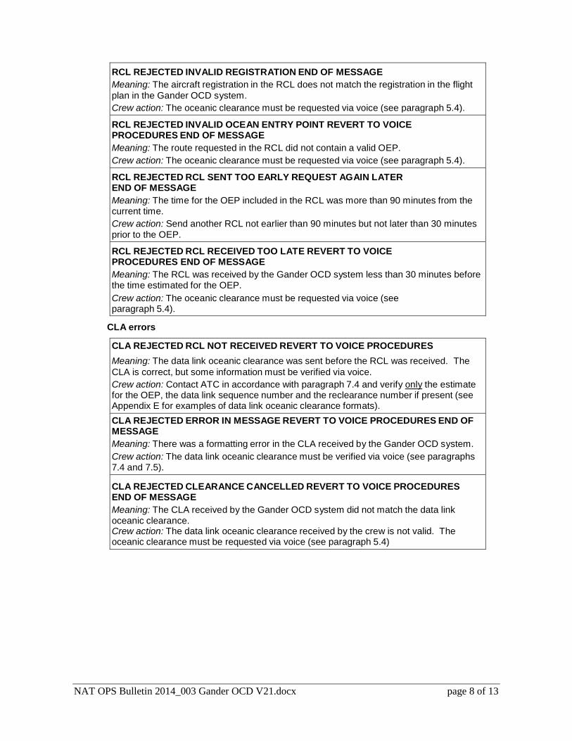
NAT OPS Bulletin 2014_003 Gander OCD V21.docx page 8 of 13
RCL REJECTED INVALID REGISTRATION END OF MESSAGE
Meaning: The aircraft registration in the RCL does not match the registration in the flight
plan in the Gander OCD system.
Crew action: The oceanic clearance must be requested via voice (see paragraph 5.4).
RCL REJECTED INVALID OCEAN ENTRY POINT REVERT TO VOICE PROCEDURES END OF MESSAGE
Meaning: The route requested in the RCL did not contain a valid OEP.
Crew action: The oceanic clearance must be requested via voice (see paragraph 5.4).
RCL REJECTED RCL SENT TOO EARLY REQUEST AGAIN LATER END OF MESSAGE
Meaning: The time for the OEP included in the RCL was more than 90 minutes from the current time.
Crew action: Send another RCL not earlier than 90 minutes but not later than 30 minutes prior to the OEP.
RCL REJECTED RCL RECEIVED TOO LATE REVERT TO VOICE PROCEDURES END OF MESSAGE
Meaning: The RCL was received by the Gander OCD system less than 30 minutes before the time estimated for the OEP.
Crew action: The oceanic clearance must be requested via voice (see paragraph 5.4).
CLA errors
CLA REJECTED RCL NOT RECEIVED REVERT TO VOICE PROCEDURES
Meaning: The data link oceanic clearance was sent before the RCL was received. The
CLA is correct, but some information must be verified via voice.
Crew action: Contact ATC in accordance with paragraph 7.4 and verify only the estimate for the OEP, the data link sequence number and the reclearance number if present (see Appendix E for examples of data link oceanic clearance formats).
CLA REJECTED ERROR IN MESSAGE REVERT TO VOICE PROCEDURES END OF MESSAGE
Meaning: There was a formatting error in the CLA received by the Gander OCD system.
Crew action: The data link oceanic clearance must be verified via voice (see paragraphs 7.4 and 7.5).
CLA REJECTED CLEARANCE CANCELLED REVERT TO VOICE PROCEDURES END OF MESSAGE
Meaning: The CLA received by the Gander OCD system did not match the data link oceanic clearance. Crew action: The data link oceanic clearance received by the crew is not valid. The oceanic clearance must be requested via voice (see paragraph 5.4)
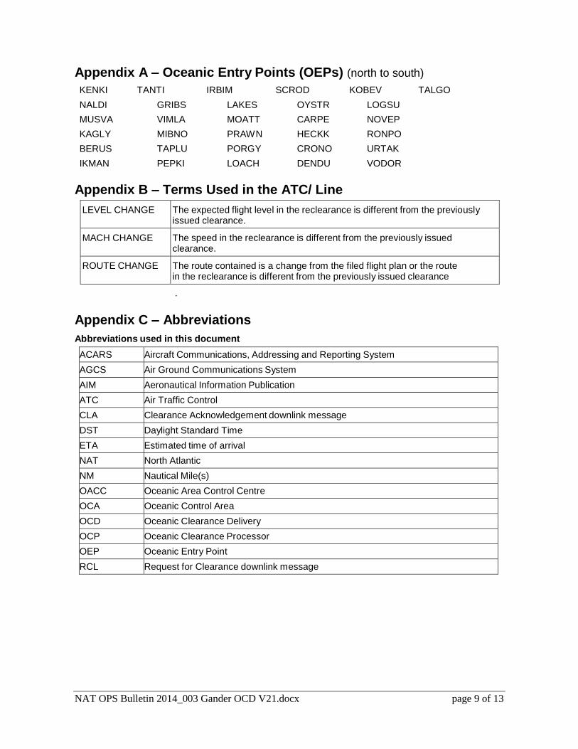
NAT OPS Bulletin 2014_003 Gander OCD V21.docx page 9 of 13
Appendix A – Oceanic Entry Points (OEPs) (north to south)
KENKI TANTI IRBIM SCROD KOBEV TALGO
NALDI GRIBS LAKES OYSTR LOGSU
MUSVA VIMLA MOATT CARPE NOVEP
KAGLY MIBNO PRAWN HECKK RONPO
BERUS TAPLU PORGY CRONO URTAK
IKMAN PEPKI LOACH DENDU VODOR
Appendix B – Terms Used in the ATC/ Line
LEVEL CHANGE The expected flight level in the reclearance is different from the previously issued clearance.
MACH CHANGE The speed in the reclearance is different from the previously issued clearance.
ROUTE CHANGE The route contained is a change from the filed flight plan or the route in the reclearance is different from the previously issued clearance Note: If the previously issued clearance was on a NAT track, the route description will change to RANDOM ROUTE
.
Appendix C – Abbreviations
Abbreviations used in this document
ACARS Aircraft Communications, Addressing and Reporting System
AGCS Air Ground Communications System
AIM Aeronautical Information Publication
ATC Air Traffic Control
CLA Clearance Acknowledgement downlink message
DST Daylight Standard Time
ETA Estimated time of arrival
NAT North Atlantic
NM Nautical Mile(s)
OACC Oceanic Area Control Centre
OCA Oceanic Control Area
OCD Oceanic Clearance Delivery
OCP Oceanic Clearance Processor
OEP Oceanic Entry Point
RCL Request for Clearance downlink message
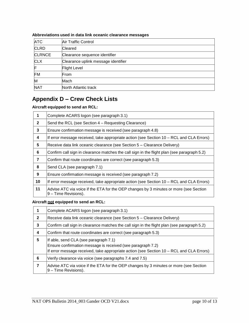
NAT OPS Bulletin 2014_003 Gander OCD V21.docx page 10 of 13
Abbreviations used in data link oceanic clearance messages
ATC Air Traffic Control
CLRD Cleared
CLRNCE Clearance sequence identifier
CLX Clearance uplink message identifier
F Flight Level
FM From
M Mach
NAT North Atlantic track
Appendix D – Crew Check Lists
Aircraft equipped to send an RCL:
1 Complete ACARS logon (see paragraph 3.1)
2 Send the RCL (see Section 4 – Requesting Clearance)
3 Ensure confirmation message is received (see paragraph 4.8)
4 If error message received, take appropriate action (see Section 10 – RCL and CLA Errors)
5 Receive data link oceanic clearance (see Section 5 – Clearance Delivery)
6 Confirm call sign in clearance matches the call sign in the flight plan (see paragraph 5.2)
7 Confirm that route coordinates are correct (see paragraph 5.3)
8 Send CLA (see paragraph 7.1)
9 Ensure confirmation message is received (see paragraph 7.2)
10 If error message received, take appropriate action (see Section 10 – RCL and CLA Errors)
11 Advise ATC via voice if the ETA for the OEP changes by 3 minutes or more (see Section 9 – Time Revisions).
Aircraft not equipped to send an RCL:
1 Complete ACARS logon (see paragraph 3.1)
2 Receive data link oceanic clearance (see Section 5 – Clearance Delivery)
3 Confirm call sign in clearance matches the call sign in the flight plan (see paragraph 5.2)
4 Confirm that route coordinates are correct (see paragraph 5.3)
5 If able, send CLA (see paragraph 7.1)
Ensure confirmation message is received (see paragraph 7.2)
If error message received, take appropriate action (see Section 10 – RCL and CLA Errors)
6 Verify clearance via voice (see paragraphs 7.4 and 7.5)
7 Advise ATC via voice if the ETA for the OEP changes by 3 minutes or more (see Section 9 – Time Revisions).
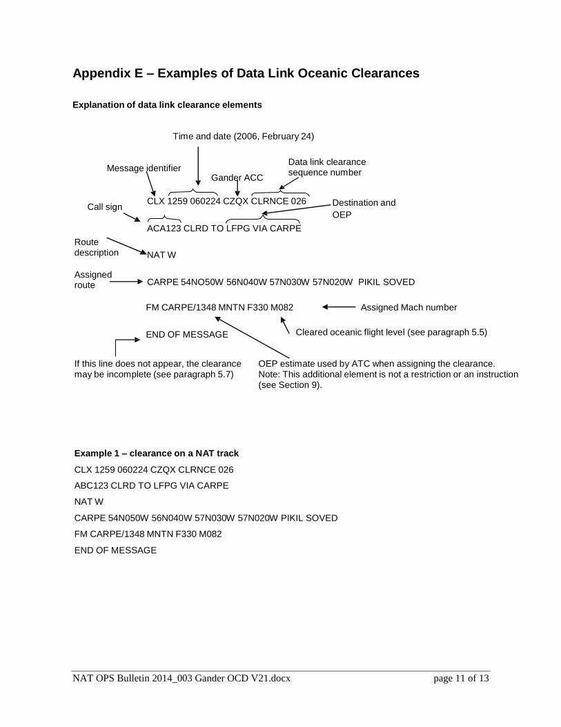
NAT OPS Bulletin 2014_003 Gander OCD V21.docx page 11 of 13
Appendix E – Examples of Data Link Oceanic Clearances
Explanation of data link clearance elements
Time and date (2006, February 24)
Message identifier
Gander ACC
Data link clearance sequence number
Call sign
Route description
CLX 1259 060224 CZQX CLRNCE 026
ACA123 CLRD TO LFPG VIA CARPE
NAT W
Destination and
OEP
Assigned route
CARPE 54NO50W 56N040W 57N030W 57N020W PIKIL SOVED
FM CARPE/1348 MNTN F330 M082
END OF MESSAGE
Assigned Mach number
Cleared oceanic flight level (see paragraph 5.5)
If this line does not appear, the clearance may be incomplete (see paragraph 5.7)
OEP estimate used by ATC when assigning the clearance. Note: This additional element is not a restriction or an instruction (see Section 9).
Example 1 – clearance on a NAT track
CLX 1259 060224 CZQX CLRNCE 026
ABC123 CLRD TO LFPG VIA CARPE
NAT W
CARPE 54N050W 56N040W 57N030W 57N020W PIKIL SOVED
FM CARPE/1348 MNTN F330 M082
END OF MESSAGE
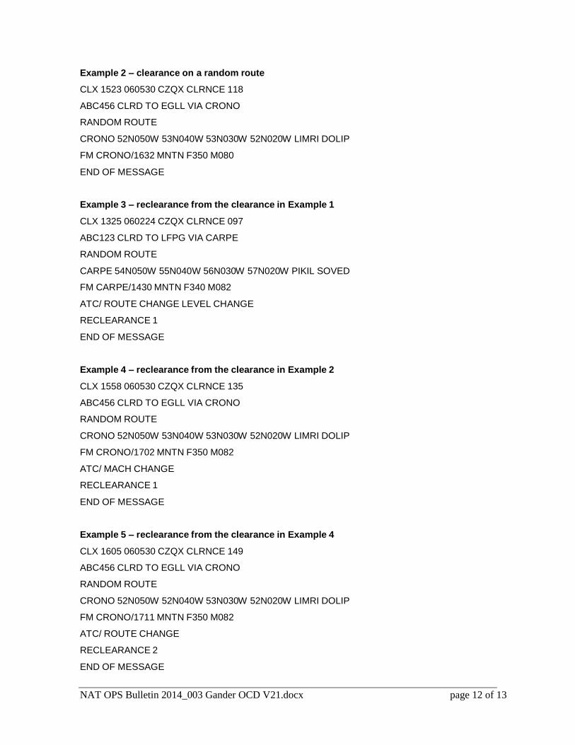
NAT OPS Bulletin 2014_003 Gander OCD V21.docx page 12 of 13
Example 2 – clearance on a random route
CLX 1523 060530 CZQX CLRNCE 118
ABC456 CLRD TO EGLL VIA CRONO
RANDOM ROUTE
CRONO 52N050W 53N040W 53N030W 52N020W LIMRI DOLIP
FM CRONO/1632 MNTN F350 M080
END OF MESSAGE
Example 3 – reclearance from the clearance in Example 1
CLX 1325 060224 CZQX CLRNCE 097
ABC123 CLRD TO LFPG VIA CARPE
RANDOM ROUTE
CARPE 54N050W 55N040W 56N030W 57N020W PIKIL SOVED
FM CARPE/1430 MNTN F340 M082
ATC/ ROUTE CHANGE LEVEL CHANGE
RECLEARANCE 1
END OF MESSAGE
Example 4 – reclearance from the clearance in Example 2
CLX 1558 060530 CZQX CLRNCE 135
ABC456 CLRD TO EGLL VIA CRONO
RANDOM ROUTE
CRONO 52N050W 53N040W 53N030W 52N020W LIMRI DOLIP
FM CRONO/1702 MNTN F350 M082
ATC/ MACH CHANGE
RECLEARANCE 1
END OF MESSAGE
Example 5 – reclearance from the clearance in Example 4
CLX 1605 060530 CZQX CLRNCE 149
ABC456 CLRD TO EGLL VIA CRONO
RANDOM ROUTE
CRONO 52N050W 52N040W 53N030W 52N020W LIMRI DOLIP
FM CRONO/1711 MNTN F350 M082
ATC/ ROUTE CHANGE
RECLEARANCE 2
END OF MESSAGE

2NAT OPS Bulletin 2014_002 OESB04Feb14.docx Page 1 of 7
Serial Number: 2014_002
Subject: Oceanic Errors Safety Bulletin
(OESB)
Issued: 4 February 2014
The purpose of North Atlantic Operations Bulletin 2014_002 is to promulgate the Oceanic Errors Safety
Bulletin (OESB).
This NAT OPS Bulletin supersedes NAT OPS Bulletin, Serial Number: 2012-029.
The OESB is promulgated by the NAT Safety Oversight Group (NAT SOG).
Questions or comments regarding this Bulletin may be directed to:
The European and North Atlantic Office of ICAO: [email protected]
NOTICE NAT Ops Bulletins are used to distribute information on behalf of the North Atlantic Systems Planning
Group (NAT SPG). The material contained therein may be developed within the working structure of the
NAT SPG or be third party documents posted at the request of a NAT SPG Member State. A printed or
electronic copy of this Bulletin, plus any associated documentation, is provided to the recipient as is and
without any warranties as to its description, condition, quality, fitness for purpose or functionality and for use
by the recipient solely for guidance only. The information published by ICAO in this document is made
available without warranty of any kind; the Organization accepts no responsibility or liability whether direct
or indirect, as to the currency, accuracy or quality of the information, nor for any consequence of its use.
The designations and the presentation of material in this publication do not imply the expression of any
opinion whatsoever on the part of ICAO concerning the legal status of any country, territory, city or area of
its authorities, or concerning the delimitation of its frontiers or boundaries.
The NAT OPS Bulletin Checklist available on www.paris.icao.int (EUR & NAT Documents,
NAT Documents), contains an up to date list of all current NAT Ops Bulletins.
There is no objection to the reproduction of extracts of information contained in this Bulletin if the source is
acknowledged.
NAT OPS BULLETIN 2014-002 – Oceanic Errors Safety Bulletin (OESB)
2NAT OPS Bulletin 2014_002 OESB04Feb14.docx Page 2 of 7
OCEANIC ERRORS SAFETY BULLETIN as of 4 February 2014
ICAO North Atlantic Working Groups composed of industry, ATC and state regulators have noted repetitive
oceanic errors. These include Gross Navigation Errors (25 NM or more), Large Height Deviations (300
feet or more) and Erosion of Longitudinal Separation. Operators are reminded that the safety of the
airspace is constantly monitored and its performance is reviewed. Thus, repeated errors present a recurring
hazard and pose a threat not only to overall flight safety but also planned reductions in separation. It is
important that operators have a continuous analysis process to evaluate oceanic errors in order to meet the
ICAO Safety Management System (SMS) standards.
This OESB is intended for distribution to industry and training centers. The OESB will also be posted on
various websites to enable broad distribution and rapid updates. In addition, the OESB should be used in
conjunction with the guidance detailed in the current edition of North Atlantic Operations and Airspace
Manual (NAT Doc 007). This manual can be found at www.paris.icao.int/ under: “EUR & NAT Documents
>NAT Documents > NAT Doc 007 (MNPS)”.
Operators should consult www.paris.icao.int/ for the most current version of the OESB under “EUR & NAT
Documents > NAT OPS Bulletins”. A sample oceanic checklist has been developed using many of the
recommendations found in this OESB and can be downloaded via the same links.
The following are recommendations to reduce oceanic errors that should be addressed in initial and recurrent
ground training:
LARGE HEIGHT DEVIATIONS
1. Conditional clearances require special attention. A Conditional Clearance is an ATC clearance given to
an aircraft with certain conditions or restrictions such as changing a flight level based on a UTC time or
a specific geographic position. The following is an example of a conditional clearance given to a crew:
Maintain FL330. After passing 20W climb to FL350. Cross 25W level. Report leaving. Report reaching.
NOTE – in this example, FL330 is the present FL.
The main part of this clearance is that after 20W the aircraft starts the climb and is maintaining the
cleared level prior to 25W.
2. In oceanic, non-radar RVSM airspace, during a climb or descent, crews must advise ATC when
leaving and reaching a flight level.
3. Each flight level change must be specifically approved by ATC. A filed flight plan with a requested
change in flight level (step climb) is not a clearance to initiate the change in altitude.
4. Crews must ensure a CORRECT understanding of when a climb or descent should be initiated or
completed.
5. Crews must exercise caution and ensure a clear understanding when ATC uses the terms “by” or “at”
when referring to a longitude crossing (for example when to make a flight level change). This applies
whether the clearance is given via voice or data link.
5.1. The following are examples of conditions or restrictions given to crews when the terms AT or BY
are used in a conditional clearance.

NAT OPS BULLETIN 2014-002 – Oceanic Errors Safety Bulletin (OESB)
2NAT OPS Bulletin 2014_002 OESB04Feb14.docx Page 3 of 7
EXAMPLES: Restriction What is expected
VOICE CLIMB TO REACH FLIGHT LEVEL 390 AT OR
BEFORE 1325
CPDLC CLIMB TO REACH F390 BY 1325
Arrange the climb so that the aircraft is at
FL390 at or before 1325 UTC.
If it will not be possible to be level at FL390 at or
before 1325 UTC, then:
VOICE: Do not commence climb and advise
ATC of the situation.
CPDLC: Do not ACCEPT the clearance; reply
UNABLE and do not climb.
VOICE DESCEND TO REACH FLIGHT LEVEL 320
BEFORE PASSING 63 NORTH 030 WEST
CPDLC DESCEND TO REACH F320 BY 63N030W
Arrange the descent so that the aircraft is at
FL320 before it crosses 63 North 30 West.
If it will not be possible to be level before
crossing 60 North 30 West, then:
VOICE: Do not commence descent and advise
ATC of the situation.
CPDLC: Do not ACCEPT the clearance; reply
UNABLE and do not descend.
(In this example the aircraft is initially at F350)
VOICE AT OR AFTER TIME 1403 DESCEND TO AND
MAINTAIN FLIGHT LEVEL 330
CPDLC AT 1403 DESCEND TO AND MAINTAIN FL330
The aircraft shall maintain FL350 until time
1403 UTC. At or after time 1403 UTC a
descent to FL330 is to commence and once
reached, FL330 is to be maintained.
If it will not be possible to meet this restriction,
then:
VOICE: Do not commence descent and advise
ATC of the situation.
CPDLC: Do not ACCEPT the clearance; reply
UNABLE and do not descend.
(In this example the aircraft is initially at F350)
VOICE
AFTER PASSING 58 NORTH 040 WEST CLIMB
TO AND MAINTAIN FLIGHT LEVEL 360
CPDLC
MAINTAIN F350
AT 58N040W CLIMB TO AND MAINTAIN F360
The aircraft shall maintain FL350 until passing
58N040W. After passing 58N0404W a climb to
FL360 is to commence and once reached,
FL360 is to be maintained.
If it will not be possible to meet this restriction,
then:
VOICE: Do not commence descent and advise
ATC of the situation.
CPDLC: Do not ACCEPT the clearance; reply
UNABLE and do not descend.
6. Crews must be diligent in reviewing performance data for their particular aircraft, so as to avoid either
requesting or accepting clearance to unrealistic flight levels which are outside of the performance
envelope of the aircraft.
NOTE: Crews must carefully consider in their performance planning the significant temperature
inversions that can frequently occur over the Atlantic Ocean. This is particularly important when
aircraft are near to maximum gross weight and when attempting to comply with flight levels dictated at
oceanic entry points.
NAT OPS BULLETIN 2014-002 – Oceanic Errors Safety Bulletin (OESB)
2NAT OPS Bulletin 2014_002 OESB04Feb14.docx Page 4 of 7
7. Crews should be aware that requesting unrealistic flight levels can seriously impact separation between
their aircraft and other NAT traffic.
NOTE: If there has been a significant change affecting the aircraft weight after the flight plan has been
computed, request a new flight plan. An example would be if you add a considerable amount of fuel to
tanker through a location where the fuel cost is high.
8. If a crew finds itself at a flight level that becomes unsustainable due to degrading performance, it is
imperative that they communicate immediately with ATC in order to coordinate a flight level change as
soon as possible.
9. Crews must be alert for situations when ATC issues clearances that have only a latitude OR a longitude
rather than a latitude AND a longitude. The clearance should be clearly understood as to when to make a
flight level change.
10. Crews must ensure they are following the correct contingency procedure in case of lost communications.
Unlike other oceans, the NAT lost communications procedure is to maintain the last assigned flight
level. ATC approval is required for all flight level changes.
11. Crews must ensure they obtain an OCEANIC clearance level prior to oceanic entry, enter the ocean at
the cleared flight level and establish a post entry point altitude check.
NOTE: Crews must be proactive to ensure that they are maintaining their cleared oceanic flight level
prior to the oceanic entry point.
12. The use of the terms “expect” or “able” by ATC is NOT a clearance. Typical phraseology is to use,
“ATC clears….”
GROSS NAVIGATION ERRORS (GNEs)
1. Fly the route received in the OCEANIC clearance – not the filed flight plan.
2. A reclearance scenario is the prime cause for most navigational errors. Crews must ensure they correctly
copy the RECLEARANCE, reprogram (and execute) the FMS (or Long Range Navigation System,
LRNS), update the Master Computer Flight Plan (CFP) and update the plotting chart. The FMS
crosschecks for the clearance should include distance and track checks between the new waypoints.
NOTE: Track and distance tables are available commercially for every ten degrees of longitude.
3. Crews must follow a RECLEARANCE (and not the filed flight plan). The captain should ensure that all
flight crew members are aware of the details of the RECLEARANCE by briefing all non-flying crew
members.
4. Ground crosschecks of the Long Range Navigation System (LRNS) should include distance and track
checks between waypoints. Enroute procedures must also include distance and track checks when
passing a waypoint.
5. The crosscheck of the FMS coordinates should include comparing the expanded coordinates against the
flight plan.
NOTE: In reduced separation standards airspace it’s imperative that crews check the expanded
coordinates of all oceanic waypoints.
6. It is strongly recommended that a plotting chart be used and procedures include a position plot
10 minutes after each waypoint annotated with the coordinates and time of the plot. Compare all oceanic
waypoints on the chart against the Master Computer Flight Plan (CFP).
7. Standard Operating Procedures (SOPs) for LRNS must include independent clearance copy, data entry
(Coordinates and/or waypoints), and independent crosschecks to verify that the clearance is correctly
programmed. These procedures must also be used when enroute changes are entered. This task cannot be
delegated.
8. There should only be one CFP on the flight deck. It should be labeled the Master and should reflect the
current cleared route of flight.
NAT OPS BULLETIN 2014-002 – Oceanic Errors Safety Bulletin (OESB)
2NAT OPS Bulletin 2014_002 OESB04Feb14.docx Page 5 of 7
9. Crews must be alert for similar sounding named oceanic boundary waypoints (e.g. PITAX versus
BERUX) when receiving the ATC clearance.
10. Crews must ensure they understand not only the requirements of oceanic procedures but also their
current position in relation to the oceanic boundary especially in areas where multiple FIRs (e.g., Brest,
Madrid and Shanwick) are in close proximity.
EROSION OF LONGITUDINAL SEPARATION
1. When transmitting waypoint position reports via voice, crews must communicate to ATC any ETAs
that change by 3 minutes or more. This is an ICAO requirement and the information is used to modify
ground-based ATC flight tracking systems.
2. Crews must adhere to the assigned (True) Mach. Operators flying Long Range Cruise or ECON to
conserve fuel are having a negative impact on the strict tolerance required for ATCs longitudinal
separation.
3. Crews should verify the accuracy of ETAs or ATAs (particularly the hour) forwarded to ATC to prevent
an error of one hour.
4. Flight crews are only required to notify a changed ETA for the oceanic entry point if it differs by 3
minutes or more from the previously notified ETA.
NOTE: Time restrictions issued by ATC must be strictly adhered to. As opposed to an estimate a
restriction is issued to ensure required spacing between two aircraft is maintained.
5. Crews must ensure that the aircraft master clock (typically the FMS) is set using an approved calibrated
time source to be used for all ETAs and ATAs.
FLIGHT PLANNING
1. Aircraft Dispatchers, Flight Followers, Flight Operations Officers, Flight Planners and crews should
ensure that Items 10 and 18 of the ICAO Flight Plan correctly display the
Communication/Navigation/Surveillance codes and airspace authorizations. The accuracy of these codes
is used in the application of reduced separation standards and performance based requirements.
NOTE: Since 15 November 2012, additional communication/navigation/surveillance codes have been
required in Fields 10 and 18 of the ICAO Flight Plan to meet performance based requirements.
2. Operators with an RNP-4 authorization should indicate this navigation specification on the flight plan.
Operators that qualify for an RNP-4 authorization but have not applied to their CAA regulator should do
so. An RNP-4 authorization is or will be required in several oceanic areas.
.3. Dispatchers and Flight Planners must ensure the filed routes around the oceanic boundary do not include
crossing multiple oceanic entry/exit points.
.4. Pilots must ensure they know current conditions to include NOTAMS (e.g. forecast turbulence in RVSM
airspace) and weather documents (e.g. ETPs and alternate airports). In addition, pilots must be
knowledgeable in the information on the computer flight plans and do basic crosschecks of fuel, winds
and groundspeeds.
CONTROLLER PILOT DATA LINK COMMUNICATIONS (CPDLC)1
1. Conditional clearances1 require special attention. A conditional clearance is an ATC clearance given to
an aircraft with certain conditions or restrictions such as changing a flight level based on a UTC time or
a specific geographic position. The following is an example of a scenario where a CPDLC conditional
1 Guidance for CPDLC communications can be found in the Global Operational Data Link Document (GOLD).
Chapter 4 contains guidance for the controller and Chapter 5 contains guidance for the flight crew. Guidance for
conditional clearances can be found in paragraph 4.2.3 for the controller and paragraph 5.3.3 for the flight crew. For
multi-element messages controllers can refer to paragraph 5.3.3.
NAT OPS BULLETIN 2014-002 – Oceanic Errors Safety Bulletin (OESB)
2NAT OPS Bulletin 2014_002 OESB04Feb14.docx Page 6 of 7
clearance was given to a crew. The crew subsequently failed to comply with the time restriction, but
reported leaving its flight level, thereby enabling the controller to catch the error.
At approximately 1133Z a CPDLC message composed of the following uplink message elements (UM)
was sent to the flight:
UM19 – MAINTAIN F370
UM21 – AT 1205 CLIMB TO AND MAINTAIN F380
UM128 – REPORT LEAVING F370
UM129 – REPORT LEVEL F380
The expected WILCO response was received by the OAC. At approximately 1134Z, a CPDLC message
composed of the following downlink message element (DM) from the aircraft was received by the OAC:
DM28 – LEAVING F370. The air traffic controller took immediate action to confirm the flight level and
to issue a clearance via voice for the flight to expedite climb to a flight level that ensured vertical
separation.
NOTE: The receipt of the LEAVING F370 message enabled prompt action to correct this error.
2. Upon receipt of a CPDLC uplink message, it is important for both pilots to independently and silently
read and verify the clearance.
3. It is important to note that the CPDLC uplink message may be more than 1 page in length. Review the
entire message carefully, in the correct order, before taking any action. It may be helpful to print the
message
NOTE: Page acknowledgements may be unique to the avionics installed in a particular aircraft. For
example, on some installations, crews cannot WILCO until the last page of a message is reviewed, while
in other installations, WILCO may be allowed on the first and subsequent pages.
NOTE: Corruptions of the CPDLC message could occur when printed. Caution should be exercised
when reviewing printed versions of CPDLC messages.
4. Both pilots should resolve any questions that they may have regarding the clearance with each other and
if necessary with ATC prior to initiating any action. If unable to fully understand the CPDLC clearance,
pilots should revert to backup voice communication.
5. Pilots should not use voice to verify that an up-linked CPDLC message has been received or to inquire if
a down-linked datalink message has been received by the ATS provider.
6. Crews should be cautious with CPDLC clearances (or messages) that are delayed.
7. Dialogues with ATC that are initiated with CPDLC should be completed using CPDLC and dialogues
begun with voice should be completed by voice and crews should make every effort not to mix the two
media.
8. Crews should avoid using the free-text method.
9. Crews should be sure that HF SELCAL is working even when CPDLC is functioning properly – do a
SELCAL check prior to oceanic entry and at each Oceanic Control Area (OCA) boundary.
GENERAL
1. Dual checking of oceanic clearance MUST be SOP (avoid physiological breaks or distractions near the
oceanic boundary or when copying and reprogramming enroute reclearances). Changes must be
communicated clearly to non-flying flight crew members so that they understand RECLEARANCES
when they relieve flying flight crew members.
2. Radio operators relay for/to controllers. The majority of oceanic communications such as position
reports or crew requests go through a radio operator. The radio operator is not an air traffic controller.
Radio operators must relay all reports and requests to ATC for approval and processing.
3. The use of the terms “expect” or “able” by ATC is NOT a clearance. Typical phraseology is to use,
“ATC clears….”
NAT OPS BULLETIN 2014-002 – Oceanic Errors Safety Bulletin (OESB)
2NAT OPS Bulletin 2014_002 OESB04Feb14.docx Page 7 of 7
4. Relays of ATC instructions between aircraft MUST be accurate. Ensure a correct read back is received
from every communication link in the relay. Always read the LRNS or the plotting chart first and then
compare it to the master source (i.e. CFP). This is a human factor’s practice that could prevent the pilot
from seeing what he/she expects to see.
5. Crews must immediately clarify any confusion about the clearance.
SLOP – STRATEGIC LATERAL OFFSET PROCEDURES (RIGHT offsets only)
1. Crews should be aware of this procedure for use in oceanic and remote airspace. SLOP should be a SOP,
not a contingency, and operators should be endorsing the use of lateral offsets for safety reasons on all
oceanic and remote airspace flights.
NOTE: SLOP should also be used on random routes due to the high density traffic and limitations of
aids such as TCAS.
2. The key to the maximum efficiency of SLOP is the randomness of using centerline, 1NM right or 2 NM
right in equal proportions.
.3. Crews should be aware of the “coast-out to coast-in” operational use of the procedure.
.4. Crews should be aware of the three SLOP options: centerline, 1 NM RIGHT offset or 2 NM RIGHT
offset.
NOTE: Operators are reminded that the current SLOP was created to reduce the risk of collision. It was
also designed to incorporate wake turbulence avoidance. SLOP enhances flight safety by reducing the
risk not only from operational errors but also crews executing a contingency with a highly accurate
LRNS.
5. Offsets to the left of centerline are NOT authorized under SLOP and should not be flown.
CONTINGENCIES
1. The 15 NM lateral offset contingency procedure is now universal for ALL oceanic areas (formerly 30
NM in the NAT and 25 NM in the Pacific). Operators should update their ground training and manuals
to reflect this change. Details of the 15 NM contingency procedure can be viewed in the NAT Doc 007
at: http://www.paris.icao.int/documents_open/files.php?subcategory_id=108 (please refer to Section
“Special Procedures”).
2. The published Weather Deviation Procedure utilizing a vertical displacement of ± 300 feet is now
universal in all oceanic areas. It is important for pilots to understand that the ICAO published Weather
Deviation Procedure is a contingency and should only be flown when an ATC clearance cannot be
obtained. Details of the weather deviation procedure can be viewed in the NAT Doc 007 at:
http://www.paris.icao.int/documents_open/files.php?subcategory_id=108 (please refer to Section
“Deviation around Severe Weather”).
Note: If the aircraft is required to deviate from track, including deviations of less than 10nm, to avoid
weather (e.g. thunderstorms), the pilot must request a revised clearance from ATC prior to deviating.
Crews must not deviate laterally or vertically without attempting to obtain an ATC Clearance. However,
if such prior ATC clearance cannot be obtained, pilots must follow published ICAO Weather Deviation
Procedures.
3. Crews are reminded to execute the correct contingency procedure in case of an emergency descent,
turbulence, etc. It is important to minimize the risk to you and other aircraft.
4. Crews should be aware that there is more than one contingency maneuver and should be familiar with
the recommended procedure for each in-flight occurrence type
- END -

Serial Number: 2014_001
Subject: Sample Oceanic Checklists Issued: 4 February 2014
The purpose of North Atlantic Operations Bulletin 2014_001 is to promulgate the Sample Oceanic Checklist and the
Sample Expanded Oceanic Checklist.
This NAT OPS Bulletin supersedes NAT OPS Bulletin, Serial Number: 2012-024.
These checklists are promulgated by the NAT Safety Oversight Group (NAT SOG).
Questions or comments regarding this Bulletin may be directed to:
The European and North Atlantic Office of ICAO: [email protected]
NOTICE NAT Ops Bulletins are used to distribute information on behalf of the North Atlantic Systems Planning Group (NAT
SPG). The material contained therein may be developed within the working structure of the NAT SPG or be third party
documents posted at the request of a NAT SPG Member State. A printed or electronic copy of this Bulletin, plus any
associated documentation, is provided to the recipient as is and without any warranties as to its description, condition,
quality, fitness for purpose or functionality and for use by the recipient solely for guidance only. The information
published by ICAO in this document is made available without warranty of any kind; the Organization accepts no
responsibility or liability whether direct or indirect, as to the currency, accuracy or quality of the information, nor for
any consequence of its use. The designations and the presentation of material in this publication do not imply the
expression of any opinion whatsoever on the part of ICAO concerning the legal status of any country, territory, city or
area of its authorities, or concerning the delimitation of its frontiers or boundaries.
The NAT OPS Bulletin Checklist available on www.paris.icao.int (EUR & NAT Documents, NAT Documents),
contains an up to date list of all current NAT Ops Bulletins.
There is no objection to the reproduction of extracts of information contained in this Bulletin if the source is
acknowledged.
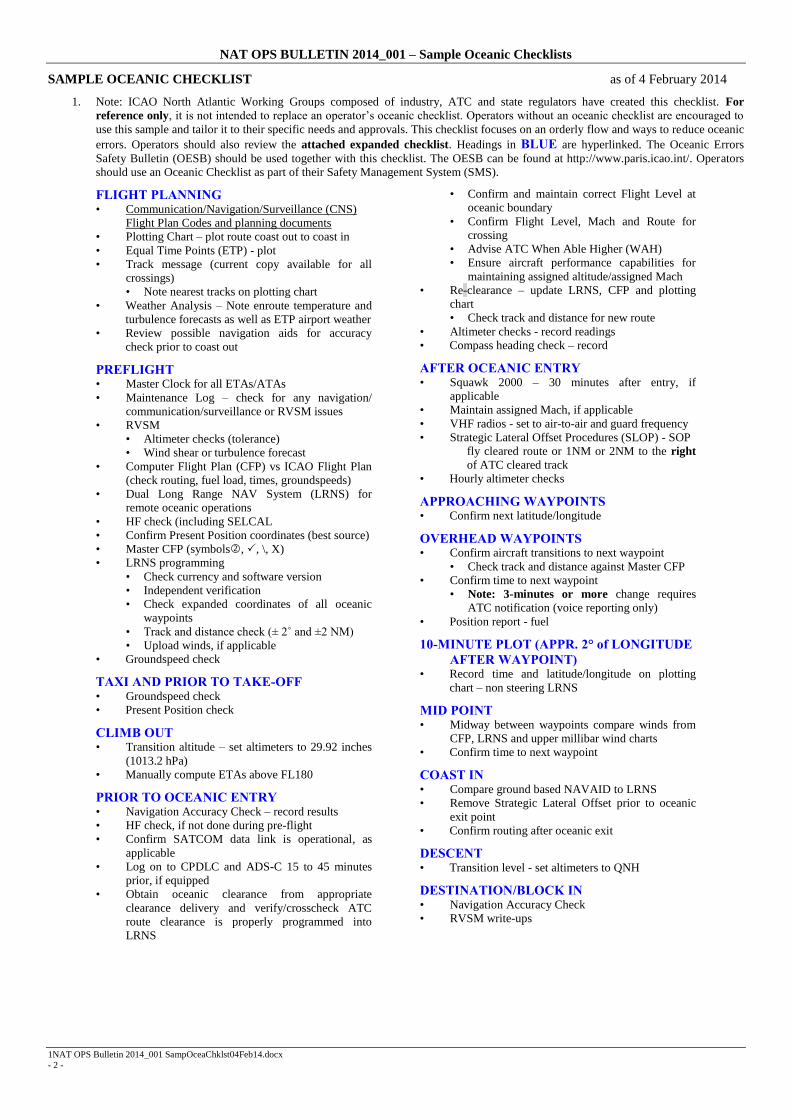
NAT OPS BULLETIN 2014_001 – Sample Oceanic Checklists
1NAT OPS Bulletin 2014_001 SampOceaChklst04Feb14.docx
- 2 -
SAMPLE OCEANIC CHECKLIST as of 4 February 2014
1. Note: ICAO North Atlantic Working Groups composed of industry, ATC and state regulators have created this checklist. For
reference only, it is not intended to replace an operator’s oceanic checklist. Operators without an oceanic checklist are encouraged to
use this sample and tailor it to their specific needs and approvals. This checklist focuses on an orderly flow and ways to reduce oceanic
errors. Operators should also review the attached expanded checklist. Headings in BLUE are hyperlinked. The Oceanic Errors
Safety Bulletin (OESB) should be used together with this checklist. The OESB can be found at http://www.paris.icao.int/. Operators
should use an Oceanic Checklist as part of their Safety Management System (SMS).
FLIGHT PLANNING • Communication/Navigation/Surveillance (CNS)
Flight Plan Codes and planning documents • Plotting Chart – plot route coast out to coast in
• Equal Time Points (ETP) - plot
• Track message (current copy available for all
crossings)
• Note nearest tracks on plotting chart
• Weather Analysis – Note enroute temperature and
turbulence forecasts as well as ETP airport weather
• Review possible navigation aids for accuracy
check prior to coast out
PREFLIGHT • Master Clock for all ETAs/ATAs
• Maintenance Log – check for any navigation/
communication/surveillance or RVSM issues
• RVSM
• Altimeter checks (tolerance)
• Wind shear or turbulence forecast
• Computer Flight Plan (CFP) vs ICAO Flight Plan
(check routing, fuel load, times, groundspeeds)
• Dual Long Range NAV System (LRNS) for
remote oceanic operations
• HF check (including SELCAL
• Confirm Present Position coordinates (best source)
• Master CFP (symbols, , \, X)
• LRNS programming
• Check currency and software version
• Independent verification
• Check expanded coordinates of all oceanic
waypoints
• Track and distance check (± 2˚ and ±2 NM)
• Upload winds, if applicable
• Groundspeed check
TAXI AND PRIOR TO TAKE-OFF • Groundspeed check
• Present Position check
CLIMB OUT • Transition altitude – set altimeters to 29.92 inches
(1013.2 hPa)
• Manually compute ETAs above FL180
PRIOR TO OCEANIC ENTRY • Navigation Accuracy Check – record results
• HF check, if not done during pre-flight
• Confirm SATCOM data link is operational, as
applicable
• Log on to CPDLC and ADS-C 15 to 45 minutes
prior, if equipped
• Obtain oceanic clearance from appropriate
clearance delivery and verify/crosscheck ATC
route clearance is properly programmed into
LRNS
• Confirm and maintain correct Flight Level at
oceanic boundary
• Confirm Flight Level, Mach and Route for
crossing
• Advise ATC When Able Higher (WAH)
• Ensure aircraft performance capabilities for
maintaining assigned altitude/assigned Mach
• Re-clearance – update LRNS, CFP and plotting
chart
• Check track and distance for new route
• Altimeter checks - record readings
• Compass heading check – record
AFTER OCEANIC ENTRY • Squawk 2000 – 30 minutes after entry, if
applicable
• Maintain assigned Mach, if applicable
• VHF radios - set to air-to-air and guard frequency
• Strategic Lateral Offset Procedures (SLOP) - SOP
fly cleared route or 1NM or 2NM to the right
of ATC cleared track
• Hourly altimeter checks
APPROACHING WAYPOINTS • Confirm next latitude/longitude
OVERHEAD WAYPOINTS • Confirm aircraft transitions to next waypoint
• Check track and distance against Master CFP
• Confirm time to next waypoint
• Note: 3-minutes or more change requires
ATC notification (voice reporting only)
• Position report - fuel
10-MINUTE PLOT (APPR. 2° of LONGITUDE
AFTER WAYPOINT) • Record time and latitude/longitude on plotting
chart – non steering LRNS
MID POINT • Midway between waypoints compare winds from
CFP, LRNS and upper millibar wind charts
• Confirm time to next waypoint
COAST IN • Compare ground based NAVAID to LRNS
• Remove Strategic Lateral Offset prior to oceanic
exit point
• Confirm routing after oceanic exit
DESCENT • Transition level - set altimeters to QNH
DESTINATION/BLOCK IN • Navigation Accuracy Check
• RVSM write-ups

NAT OPS BULLETIN 2014_001 – Sample Oceanic Checklists
1NAT OPS Bulletin 2014_001 SampOceaChklst04Feb14.docx
- 3 -
SAMPLE EXPANED OCEANIC CHECKLIST as of 4 February 2014
Note: ICAO North Atlantic Working Groups composed of industry, ATC and state regulators have created this
checklist. For reference only, it is not intended to replace an operator’s oceanic checklist. Operators without an
oceanic checklist are encouraged to use this sample and tailor it to their specific needs and approvals. This checklist
focuses on an orderly flow and ways to reduce oceanic errors. The Oceanic Errors Safety Bulletin (OESB) should be
used together with this checklist. The OESB can be found at http://paris.icao.int/ . Operators should use an Oceanic
Checklist as part of their Safety Management System (SMS).
FLIGHT PLANNING
• Communication/Navigation/Surveillance (CNS) Flight Plan Codes and planning documents
Review the ATC flight plan with emphasis on items 10A and B and Item 18. Ensure that the appropriate
CNS and Performance-based Navigation codes are properly filed in field 10 and 18 of the flight plan. Each
aircraft’s MEL should be reviewed for system deferrals that may affect the CNS capabilities of the aircraft.
The remarks and exceptions column should provide the specific guidance for flight plan filing. The operators
manual system should be updated if necessary to require flight plan amendments when CNS capabilities are
changed during the preflight planning phase prior to departure. The manual should contain procedures for
flight plan amendments and cancellations as appropriate.
• Oceanic Documents
Operators are encouraged to develop a flight planning checklist to ensure they have the necessary documents before
departure. The checklist should include, but is not limited to, the following:
Master Computer Flight Plan
NOTAMS for departure, destination, alternate(s), ETOPS alternates (as applicable) and oceanic FIRs
Weather for departure, destination, alternate(s), ETOPS alternates (as applicable)
Track Message(s)
SIG WX Chart
ETP(s) Wind Tables or Millibar Charts for Flight Levels or Altitudes
GPS NOTAMS (as applicable)
Volcanic Ash Information
PIREPS
Plotting Charts
AIREP Form (as applicable) for position report
NOTE: Items 10 and 18 of the ICAO Flight plan require more detail to indicate the operators
communication/navigation/surveillance capabilities and authorizations. These additional codes are necessary to meet
performance based requirements and are noted in the ICAO PANS ATM 4444 document.
• Plotting Chart
A plotting chart of appropriate scale should be used for oceanic operations. This includes using a plotting chart for
published oceanic routes and tracks. ICAO groups who review oceanic errors have determined that the routine use of a
plotting chart is an excellent aid to reduce lateral errors. A plotting chart can also serve as a critical aid in case of partial
or total navigation failure. It should be noted that the pilot should read from the plotting chart back to the master CFP
when verifying data. To read from the Master CFP to the plotting chart is a human factor’s issue that has led to errors
based on seeing what we expect to see.
• Equal Time Point (ETP)
ETPs should be computed for contingencies such as medical divert, engine loss or rapid depressurization. A
simultaneous engine loss and rapid depressurization should also be considered. It is advisable to note the ETPs on the
plotting chart. Crewmembers should review with each other the appropriate diversion airport(s) when crossing ETPs.
Pilot procedures should also include a manual method for computing ETPs. Crews should not enter ETPs in the active
route of the Long Range Navigation System (LRNS) as this has led to Gross Navigation Errors.

NAT OPS BULLETIN 2014_001 – Sample Oceanic Checklists
1NAT OPS Bulletin 2014_001 SampOceaChklst04Feb14.docx
- 4 -
• Track message
Crews shall1 have a current track message even if filed for a random route or filed above North Atlantic MNPSA.
Reviewing the date, effective Zulu time and Track Message Identifier (TMI) ensures having a current track message on
board. The TMI is linked to the Julian Date. Operators must also ensure that their flight planning and operational
control process notify crewmembers in a timely manner of any amendments to the daily track message. Plotting
adjacent tracks and/or crossing tracks whilst on a random route can help situational awareness in case the crew needs to
execute a contingency procedure.
• Weather Analysis
Crews must note enroute temperature and turbulence forecasts as well as ETP airport weather
• Review possible navigation aids for accuracy check prior to coast out
It is good practice to discuss in advance a primary and secondary ground based navigational aid that will be used to
verify the accuracy of the LRNS. This planning may help to identify intended navigation aids that are limited or
NOTAMed unusable and is helpful when departing airports close to oceanic airspace. Examples include Shannon
(EINN), Lisbon (LPPT), Boston (KBOS), etc.
PREFLIGHT
• Master Clock
It is a requirement to have a master clock on board synchronized to UTC or GPS. This time source, which is typically
the Flight Management System (FMS), must be used for all ETAs and ATAs. The use of multiple time sources on the
aircraft has led to inconsistencies in reporting times to ATC and resulted in a loss of longitudinal separation.
• Maintenance Log
Before entering a special area of operation, crews should focus on any write-ups that affect communication, navigation,
surveillance or RVSM requirements. Any discrepancies noted in the maintenance log or during the walk-around may
require delays or rerouting.
• RVSM
Required equipment includes two primary independent altimetry sources, one altitude alert system and one automatic
altitude control system. In most cases a functioning transponder that can be linked to the primary altimetry source is
also required. Crews should note any issues that can affect accurate altimetry.
• Altimeter checks
Before taxi, crews should set their altimeters to the airport QNH. Both primary altimeters must agree within ± 75 feet of
field elevation. The two primary altimeters must also agree within the limits noted in the aircraft operating manual.
• Wind Shear or Turbulence Forecast
The Master Computer Flight Plan (CFP) with projected wind shear or the turbulence forecast documents should be
reviewed for flights in RVSM airspace. Forecast severe turbulence could lead to RVSM suspension. Operators are
cautioned against flight planning through areas of forecast greater than moderate turbulence.
• Computer Flight Plan (CFP)
The document designated as the Master CFP should be carefully checked for date, type aircraft, fuel load and
performance requirements. Crosschecks should also be done for routing and forecast groundspeeds. The CFP should be
carefully checked against the ICAO filed flight plan to ensure the routing is in agreement with both documents. The
enroute time on the CFP should be compared against the distance to destination for a reasonable groundspeed. The
enroute time should also be compared against the total distance for a reasonable fuel load.
• Dual Long Range NAV System (LRNS)
Two operational LRNSs are required for remote oceanic operations. A single FMS receiving inputs from two navigation
sensors is not considered to be two LRNSs.
• HF check
1 Doc 7030 – 6.4.1.2
NAT OPS BULLETIN 2014_001 – Sample Oceanic Checklists
1NAT OPS Bulletin 2014_001 SampOceaChklst04Feb14.docx
- 5 -
An HF check should be conducted on the primary and secondary HF radios in areas where dual HF radios are required.
If possible, the HF checks should be done on the ground or before entering oceanic airspace. A SELCAL check should
also be accomplished at each Oceanic Control Area (OCA) boundary even if datalink equipped.
• Confirm Present Position coordinates
Both pilots should independently verify the present position coordinates using either published ramp coordinates or
determine position from the airfield diagram. They should not rely solely on the present position when the LRNS was
shut down from the previous flight. A master source such as an enroute chart should also be used to confirm accuracy of
coordinates at the oceanic boundaries.
• Master CFP symbols
Operators are encouraged to use consistent symbology on the Master CFP. For example, a circled number () means
the second crewmember has independently verified the coordinates entered or crosschecked by the first crewmember. A
checkmark () may indicate that the track and distances have been confirmed. A diagonal line ( \ ) may indicate that the
crew has confirmed the coordinates of the approaching and next way point. An X-symbol (X) may indicate having
flown overhead the way point.
• LRNS programming
Check currency and software version
It is important to check the effective date of the database. Crews should note if the database is projected to
expire during their trip. Crews are discouraged from flying with expired databases. MELs may allow relief to
fly with an expired database but require the crews to manually crosscheck all data. The software version of the
database should also be confirmed in case there has been a change.
Independent verification
It is critical that one crewmember enters waypoint coordinates and that these are independently checked by
another crewmember. It should be noted that the pilot should read from the FMS screen back to the master
CFP when verifying data. To read from the Master CFP to the FMS is a human factor’s issue that has lead to
errors based on seeing what we expect to see.
Check expanded coordinates of waypoints
Most FMSs allow entering abbreviated oceanic coordinates. There have been cases when there was an error in
the expanded waypoint coordinate, but crews only checked the abbreviated coordinate. Verifying only the
abbreviated coordinate could lead to a lateral error. In reduced separation standards, it’s imperative that crews
check the expanded coordinates of all oceanic waypoints. Flight crews should conduct a magnetic course and
distance check between waypoints to further verify waypoint coordinates.
Track and distance check
To minimize oceanic errors, it is important to conduct a magnetic course and distance check from oceanic
entry to oceanic exit. Operators should establish a tolerance such as ± 2˚ and ± 2NM. The course and distance
check comparing the Master CFP against the LRNS are critical in detecting errors that may not have been
noticed by simply checking coordinates. A difference of more than 2˚ between waypoints may be due to a
difference of the magnetic variation in the database versus the variation used in the Master CFP. Any
difference outside the ± 2˚ or ± 2NM should be rechecked and verified.
Upload winds
Some LRNS units allow the crew to upload projected winds. This procedure allows more accurate reporting of
ETAs.
• Groundspeed check
The groundspeed should be noted before taxiing the aircraft. Crews should expect the groundspeed to read zero (0)
knots. This procedure is a good practice to detect an error that may be developing in the LRNS.
TAXI AND PRIOR TO TAKE-OFF
• Groundspeed check
During taxi to the active runway, pilots should check the groundspeed to see if it is reasonable.
• Present Position check
NAT OPS BULLETIN 2014_001 – Sample Oceanic Checklists
1NAT OPS Bulletin 2014_001 SampOceaChklst04Feb14.docx
- 6 -
This Present Position check is conducted after leaving the gate. Check for gross difference between this Present Position
and the gate coordinates. This check will alert the crew to possible error in the LRNS database that can be
investigated/corrected prior to take-off.
CLIMB OUT
• Transition altitude
Crews should brief the transition altitude based on information from the approach plate. After climbing through the
transition altitude, the altimeters should be reset to 29.92 inches or 1013.2 hPa.
• Manually compute ETAs
After climbing above the sterile altitude and time permitting crews should manually compute ETAs from departure to
destination. These should be noted on the Master CFP. This is an excellent crosscheck against ETAs computed by the
LRNS.
PRIOR TO OCEANIC ENTRY
• Navigation Accuracy Check
Before oceanic entry, the accuracy of the LRNS should be checked against a ground-based NAVAID. The results of the
accuracy check should be recorded with the time and position. A large difference between the ground-based NAVAID
and the LRNS may require immediate corrective action. Operators should establish a navigation accuracy check
tolerance based on the type LRNS. It is not advisable for crews to attempt to correct an error by doing an air alignment
or by manually updating the LRNS since this has often contributed to a Gross Navigation Error.
• HF checks
If the crew was unable to accomplish the HF and SELCAL checks on the ground, these checks should be accomplished
before oceanic entry.
• SATCOM data communication
Flight crews should check that SATCOM data link is operational, if applicable, before oceanic entry if SATCOM data
link is planned on being used.
• Log on to CPDLC or ADS-C
Operators approved to use Controller Pilot Data Link Communications (CPDLC) and/or Automatic Dependent
Surveillance Contract (ADS-C) should log on to the appropriate FIR 15 to 45 minutes prior to the boundary.
• Obtain oceanic clearance
Both pilots must obtain the oceanic clearance from the appropriate clearance delivery. (Clearance via voice should be at
least 40 minutes prior to oceanic entry and via data link should be 30 to 90 minutes prior to oceanic entry). Oceanic
clearances from Reykjavik centre shall be obtained 15-45 minutes prior to oceanic entry. It is important that both pilots
confirm and ensure the aircraft enters the ocean at the altitude assigned in the oceanic clearance (this may be different
than the domestic cleared flight level). An oceanic clearance typically includes a route, flight level and assigned
MACH. Crews should include their requested flight level in their initial clearance request. Some oceanic centers require
pilots to advise them at the time of their oceanic clearance “When Able Higher” (WAH). Crews should be confident
that they are able to maintain requested flight levels based on aircraft performance capabilities.
• Re-clearance
A re-clearance (that is different from the oceanic route requested with the filed flight plan) is the number one scenario
which leads to a Gross Navigation Error. Crews must be particularly cautious when receiving a re-clearance. Both
pilots should receive and confirm the new routing and conduct independent crosschecks after the LRNS, Master CFP
and Plotting Chart are updated. It is critical that crews check the magnetic course and distance between the new
waypoints as noted in PREFLIGHT under the paragraph “LRNS Programming”.
NOTE: Track and distance tables are available commercially for every ten degrees of longitude.
• Altimeter checks
Crews are required to check the two primary altimeters which must be within 200 ft of each other. This check is
conducted while at level flight. The stand-by altimeter should also be noted. The altimeter readings should be recorded
along with the time.
• Compass heading check (Inertial Navigation Systems)
NAT OPS BULLETIN 2014_001 – Sample Oceanic Checklists
1NAT OPS Bulletin 2014_001 SampOceaChklst04Feb14.docx
- 7 -
It is recommended to conduct a compass heading check and record the results when inertial systems are the only means
of long range navigation. The check can also aid in determining the most accurate compass if a problem develops over
water.
AFTER OCEANIC ENTRY
• Squawk 2000
Thirty minutes after oceanic entry crews should Squawk 2000, if applicable. There may be regional differences such as
maintaining last assigned Squawk in the West Atlantic Route System (WATRS). Crews transiting Reykjavik’s airspace
must maintain last assigned Squawk.
• Maintain assigned Mach
Some oceanic clearances include a specific Mach. There is no tolerance for this assigned Mach. The increased emphasis
on longitudinal separation requires crew vigilance in a separation based on assigned Mach. The requirement is to
maintain the true Mach which has been assigned by ATC. In most cases, the true Mach is the indicated Mach. Some
aircraft, however, require a correction factor.
NOTE: Crews must ensure they fly the assigned Mach and not ECON mode or Long Range Cruise.
• VHF radios
After going beyond the range of the assigned VHF frequency, crews should set their radios to air-to-air (123.45) and
guard frequency (121.5).
• Strategic Lateral Offset Procedures (SLOP)
The SLOP should be Standard Operating Procedure (SOP) for all oceanic crossings. This procedure was developed to
reduce the risk from highly accurate navigation systems or operational errors involving the ATC clearance. SLOP also
replaced the contingency procedure developed for aircraft encountering wake turbulence. Depending upon winds aloft,
coordination between aircraft to avoid wake turbulence may be necessary. This procedure, which distributes traffic
between flying centerline, 1 NM or 2 NM right of centerline, greatly reduces the risk to the airspace by the nature of the
randomness. Operators that have an automatic offset capability should fly 1 NM or 2 NM right of the centerline.
Aircraft that do not have an automatic offset capability (that can be programmed in the LRNS) should fly the centerline
only. SLOP was not developed to be used only in contingency situations.
• Hourly altimeter checks
Crews are required to observe the primary and stand-by altimeters each hour. It is recommended that these hourly
checks be recorded with the readings and times. This documentation can aid crews in determining the most accurate
altimeter if an altimetry problem develops.
APPROACHING WAYPOINTS
• Confirm next latitude/longitude
Within a few minutes of crossing an oceanic waypoint crews should crosscheck the coordinates of that waypoint and
the next waypoint. This check should be done by comparing the coordinates against the Master CFP based on the
currently effective ATC clearance.
OVERHEAD WAYPOINTS
• Confirm aircraft transitions to next waypoint
When overhead an oceanic waypoint, crews should ensure that the aircraft transitions to the next leg. This is confirmed
by noting the magnetic heading and distance to the next waypoint compared against the Master CFP.
• Confirm time to next waypoint
Crews must be vigilant in passing an accurate ETA to ATC for the next waypoint. When transmitting waypoint position
reports via voice, a change of three (3) minutes or more requires that ATC be notified in a timely manner. There is
substantial emphasis on reducing longitudinal separation and this timely update must be a priority for the crews.
• Position report
After passing over the oceanic waypoint, crews that give a position report to ATC must use the standard format. Crews
should also note and record their fuel status at each oceanic waypoint. This is especially important if the cleared route
and flight level differ significantly from the filed flight plan.

NAT OPS BULLETIN 2014_001 – Sample Oceanic Checklists
1NAT OPS Bulletin 2014_001 SampOceaChklst04Feb14.docx
- 8 -
NOTE: Effective 18 November 2010 ICAO Annex 3 (International Standards and Recommended Practices-
Meteorological Service for International Air Navigation) Amendment 75 eliminated the requirement for routine voice
reports related to weather.
NAT OPS BULLETIN 2014_001 – Sample Oceanic Checklists
1NAT OPS Bulletin 2014_001 SampOceaChklst04Feb14.docx
- 9 -
10-MINUTE PLOT
• Record time and latitude/longitude on plotting chart
Approximately 10 minutes after passing an oceanic waypoint, crews should plot the latitude, longitude and time on the
plotting chart. It is advisable to plot the non-steering LRNS. A 10-minute plot can alert the crew to any lateral deviation
from their ATC clearance prior to it becoming a Gross Navigation Error. A good crosscheck for the position of the 10-
minute plot is that it is approximately 2˚ of longitude past the oceanic waypoint.
MIDPOINT
• Midway between waypoints
It is good practice to crosscheck winds midway between oceanic waypoints by comparing the Master CFP, LRNS and
upper millibar wind chart. This crosscheck will also aid crews in case there is a need for a contingency procedure such
as Dead Reckoning (DR).
• Confirm time
It is recommended that during a wind check the crews also confirm the ETA to the next waypoint. When transmitting
waypoint position reports via voice, a change of three (3) minutes or more requires that ATC be notified in a timely
manner.
COAST IN
• Compare ground based NAVAID to LRNS
When departing oceanic airspace and acquiring ground based NAVAIDs, crews should note the accuracy of the LRNS
by comparing it to those NAVAIDs. Any discrepancy should be noted in the Maintenance Log.
• Remove Strategic Lateral Offset
Crews using a Lateral Offset of 1 NM or 2 NM right of centerline at oceanic entry need a procedure to remove this
Lateral Offset at coast in prior to exiting oceanic airspace. It is advisable to include this as a checklist item.
• Confirm routing after oceanic exit
Before entering the domestic route structure, crews must confirm their routing to include aircraft speed.
NOTE: Crews experiencing loss of communications leaving oceanic airspace should follow State guidance as
published in AIPs.
DESCENT
• Transition level
During the approach briefing, crews should note the transition level on the approach plate or verified by ATIS. Crews
must be diligent when descending through the transition level to reset the altimeters to QNH. This is particularly
important when encountering IFR, night or high terrain situations. Any confusion between a QNH set with inches of
Mercury or hPa must be clarified.
DESTINATION/BLOCK IN
• Navigation Accuracy Check
When arriving at the destination gate, crews should note any drift or circular error in the LRNS. A GPS Primary Means
system normally should not exceed 0.27 NM for the flight. Some inertial systems may drift as much as 2 NM per hour.
Because the present generation of LRNSs is highly accurate, operators should establish a drift tolerance which if
exceeded would require a write-up in the Maintenance Log. RNP requirements demand that drift be closely monitored.
• RVSM write-ups
Problems noted in the altimetry system, altitude alert or altitude hold must be noted in the Maintenance Log. The
RVSM airspace is closely monitored for any Height Deviations. An aircraft not meeting the strict RVSM standards
must not be flight-planned into RVSM airspace without corrective action.
- END -
NAT OPS Bulletin 2013_005 NewServcGander.docx
Serial Number: 2013_005
Subject: New Service Notification for
Gander Oceanic Control Area
Issued: 21 November 2013
The purpose of this North Atlantic Operations Bulletin 2013_005 is to notify and inform operators of a new
service being offered in the Gander Oceanic Control Area (OAC).
Any queries about the content of the attached document should be addressed to:
Noel Dwyer
International Coordination - ATS
E-mail: [email protected]
NOTICE NAT Ops Bulletins are used to distribute information on behalf of the North Atlantic Systems Planning
Group (NAT SPG). The material contained therein may be developed within the working structure of the
NAT SPG or be third party documents posted at the request of a NAT SPG Member State. A printed or
electronic copy of this Bulletin, plus any associated documentation, is provided to the recipient as is and
without any warranties as to its description, condition, quality, fitness for purpose or functionality and for use
by the recipient solely for guidance only. The information published by ICAO in this document is made
available without warranty of any kind; the Organization accepts no responsibility or liability whether direct
or indirect, as to the currency, accuracy or quality of the information, nor for any consequence of its use.
The designations and the presentation of material in this publication do not imply the expression of any
opinion whatsoever on the part of ICAO concerning the legal status of any country, territory, city or area of
its authorities, or concerning the delimitation of its frontiers or boundaries.
The NAT OPS Bulletin Checklist available on www.paris.icao.int (EUR & NAT Documents,
NAT Documents), contains an up to date list of all current NAT Ops Bulletins.
There is no objection to the reproduction of extracts of information contained in this Bulletin if the source is
acknowledged.
NAT OPS BULLETIN 2013_005 – New Service Notification for Gander Oceanic Control Area
NAT OPS Bulletin 2013_005 NewServcGander.docx
*NEW SERVICE NOTIFICATION FOR GANDER OCEANIC
CONTROL AREA*
What’s New
Gander Oceanic Area Control Center (OACC) has instituted a procedure whereby
flight crews transiting the Gander Oceanic Control Area (OCA) will be advised if
higher flight levels become available for their flight.
How It’s Done
Newly developed functionality in the Gander Automated Air Traffic System
(GAATS+) will routinely interrogate a flight’s vertical profile to determine if higher
flight levels have become available. When this occurs the Gander Oceanic controller
will verify the separation, complete all necessary coordination, and adhere to all
safety related procedures before advising the flight that a climb is available, if
requested.
Why It’s Needed
NAT customers have indicated that the ability to conduct mid-ocean step climbs
enable more fuel-efficient flight profiles. Recent analysis indicates that, although
initiatives such as the Reduced Longitudinal Separation Minimum (RLongSM) of five
minutes have been in place for over two years, many qualified flights are not
availing of the airspace flexibility by means of making mid ocean requests. This may
be attributable in part to previous experience on the flight deck that, due to traffic
density, profile changes would not be available once a flight has entered oceanic
airspace.
NAT OPS BULLETIN 2013_005 – New Service Notification for Gander Oceanic Control Area
NAT OPS Bulletin 2013_005 NewServcGander.docx
This new initiative will enable the Gander oceanic controller to be proactive by
providing information that could aid in flight deck decision making that result in fuel
savings and reductions in greenhouse gas emissions.
What Flight Crews Will See (via uplink message (UM) 169) or Hear (on HF
via Gander Radio)
“(FLIGHT IDENT) HIGHER FLIGHT LEVEL IS AVAILABLE IF REQUESTED, ADVISE
INTENTIONS”
What Flight Crews Should Do
If a climb would be beneficial to the flight, use CPDLC downlink message (DM) 9
“REQUEST CLIMB TO [level]” or request higher with Gander Radio via HF voice.
If a higher flight level is not requested, use CPDLC DM 3 “ROGER” or advise Gander
Radio via HF voice.
- END -

Reykjavik Data Link OCD Version 3 Page 1 of 12
Crew Procedures Effective 5 September 2013
Serial Number: 2013-004
Subject: Reykjavik Data Link Oceanic
Clearance Delivery (OCD) Crew Procedures
Version 3
Effective: 5 September 2013
The purpose of North Atlantic Operations Bulletin 2013-004 is to provide flight crew procedures related to
the delivery of oceanic clearances via data link to aircraft by the Reykjavik Oceanic Area Control Centre
(OAC).
The Reykjavik OAC provides an air traffic control service within the Reykjavik Oceanic Control Area
(OCA). Data Link Oceanic Clearance Delivery (OCD) service is provided via VHF and satellite to ACARS
equipped aircraft via network service providers ARINC and SITA.
This NAT OPS Bulletin Serial Number: 2013_004 supersedes NAT OPS Bulletin Serial Number: 2012_018
Any queries about the content of the attached document should be addressed to:
Bjarni K. Stefansson
Reykjavik Oceanic Area Control Centre
E-mail: [email protected]
NOTICE NAT Ops Bulletins are used to distribute information on behalf of the North Atlantic Systems Planning
Group (NAT SPG). The material contained therein may be developed within the working structure of the
NAT SPG or be third party documents posted at the request of a NAT SPG Member State. A printed or
electronic copy of this Bulletin, plus any associated documentation, is provided to the recipient as is and
without any warranties as to its description, condition, quality, fitness for purpose or functionality and for use
by the recipient solely for guidance only. The information published by ICAO in this document is made
available without warranty of any kind; the Organization accepts no responsibility or liability whether direct
or indirect, as to the currency, accuracy or quality of the information, nor for any consequence of its use.
The designations and the presentation of material in this publication do not imply the expression of any
opinion whatsoever on the part of ICAO concerning the legal status of any country, territory, city or area of
its authorities, or concerning the delimitation of its frontiers or boundaries.
The NAT OPS Bulletin Checklist available on www.paris.icao.int (EUR & NAT Documents,
NAT Documents), contains an up to date list of all current NAT Ops Bulletins.
There is no objection to the reproduction of extracts of information contained in this Bulletin if the source is
acknowledged.

NAT OPS BULLETIN 2013-004 – Reykjavik OCD Crew Procedures Version 3
Reykjavik Data Link OCD Version 3 Page 2 of 12
Crew Procedures Effective 5 September 2013
REYKJAVIK DATA LINK
OCEANIC CLEARANCE DELIVERY (OCD)
CREW PROCEDURES
Reykjavik Oceanic Area Control Centre Operations Building
NAT OPS BULLETIN 2013-004 – Reykjavik OCD Crew Procedures Version 3
Reykjavik Data Link OCD Version 3 Page 3 of 12
Crew Procedures Effective 5 September 2013
1. CONTENTS
Contents ................................................................................................................................................... 3 Summary of Changes .............................................................................................................................. 4 Abbreviations .......................................................................................................................................... 4 1. Introduction ..................................................................................................................................... 5 2. Requesting Clearance ...................................................................................................................... 6 3. Clearance Delivery .......................................................................................................................... 7 4. Clearance Acknowledgement .......................................................................................................... 8 5. Clearance Negotiation ..................................................................................................................... 8 6. Reclearances .................................................................................................................................... 8 7. Time Revisions ................................................................................................................................ 8 8. RCL and CLA Errors ....................................................................................................................... 9 9. Terms Used in the ATC/ Line ....................................................................................................... 10 10. Explanation of Data Link Clearance Elements .......................................................................... 11
Any Queries relating to this document should be addressed to:
Bjarni K. Stefansson
Reykjavik Oceanic Area Control Centre
e-mail: [email protected]

NAT OPS BULLETIN 2013-004 – Reykjavik OCD Crew Procedures Version 3
Reykjavik Data Link OCD Version 3 Page 4 of 12
Crew Procedures Effective 5 September 2013
2. SUMMARY OF CHANGES
The following changes have been made in this version of the document:
Paragraph Change
2.3 If the flight planned route does not contain a waypoint on the Reykjavik CTA
boundary then the Entry Point in the CLX message will normally be a system
calculated boundary crossing point.
3.3 If the flight planned route does not contain a waypoint on the Reykjavik CTA
boundary then the Entry Point in the CLX message will normally be a system
calculated boundary crossing point.
(Subsequent paragraphs were renumbered).
3. ABBREVIATIONS
ACARS Aircraft Communications, Addressing and Reporting System
AFIS Aerodrome Flight Information Service
ARINC * Aeronautical Radio Incorporated
CLA * Clearance Acknowledgement downlink message
CLX * Oceanic Clearance uplink message
CTA Control Area
ETA Estimated Time of Arrival
FDPS Flight Data Processing System
HF High Frequency
ICAO International Civil Aviation Organization
NAT North Atlantic
OAC Oceanic Area Control Centre
OCA Oceanic Control Area
OCD * Oceanic Clearance Delivery
OEP * Oceanic Entry Point
RCL * Request Oceanic Clearance downlink mesage
SITA * Société Internationale de Télécommunications Aéronautiques
TMI * Track Message Ident number
VHF Very High Frequency
* designates an abbreviation that is not included in ICAO DOC8400 – ICAO Abbreviations and Codes.
NAT OPS BULLETIN 2013-004 – Reykjavik OCD Crew Procedures Version 3
Reykjavik Data Link OCD Version 3 Page 5 of 12
Crew Procedures Effective 5 September 2013
4. 1. INTRODUCTION
1.1 The Reykjavik Oceanic Area Control Centre (OAC) provides an air traffic control service within the
Reykjavik Oceanic Control Area (OCA). Data Link Oceanic Clearance Delivery (OCD) service is
provided via VHF and satellite to ACARS equipped aircraft via network service providers ARINC
and SITA. If the flight crew is uncertain about any aspect of the data link OCD process, they should
contact:
Iceland Radio on HF, VHF or SATCOM voice; or
Reykjavik Control on VHF.
1.2 The OCD service is implemented in accordance with the standard “Data-Link Application System
Document (DLASD) for the Oceanic Clearance Data-Link Service” ED-106A. This standard is also
frequently referred to as the ARINC Specification 623 for Oceanic Clearance.
1.3 There are no specific flight planning requirements for the Reykjavik OCD service.
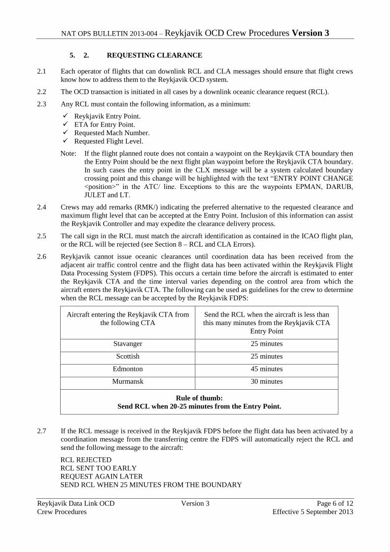
NAT OPS BULLETIN 2013-004 – Reykjavik OCD Crew Procedures Version 3
Reykjavik Data Link OCD Version 3 Page 6 of 12
Crew Procedures Effective 5 September 2013
5. 2. REQUESTING CLEARANCE
2.1 Each operator of flights that can downlink RCL and CLA messages should ensure that flight crews
know how to address them to the Reykjavik OCD system.
2.2 The OCD transaction is initiated in all cases by a downlink oceanic clearance request (RCL).
2.3 Any RCL must contain the following information, as a minimum:
Reykjavik Entry Point.
ETA for Entry Point.
Requested Mach Number.
Requested Flight Level.
Note: If the flight planned route does not contain a waypoint on the Reykjavik CTA boundary then
the Entry Point should be the next flight plan waypoint before the Reykjavik CTA boundary.
In such cases the entry point in the CLX message will be a system calculated boundary
crossing point and this change will be highlighted with the text “ENTRY POINT CHANGE
<position>” in the ATC/ line. Exceptions to this are the waypoints EPMAN, DARUB,
JULET and LT.
2.4 Crews may add remarks (RMK/) indicating the preferred alternative to the requested clearance and
maximum flight level that can be accepted at the Entry Point. Inclusion of this information can assist
the Reykjavik Controller and may expedite the clearance delivery process.
2.5 The call sign in the RCL must match the aircraft identification as contained in the ICAO flight plan,
or the RCL will be rejected (see Section 8 – RCL and CLA Errors).
2.6 Reykjavik cannot issue oceanic clearances until coordination data has been received from the
adjacent air traffic control centre and the flight data has been activated within the Reykjavik Flight
Data Processing System (FDPS). This occurs a certain time before the aircraft is estimated to enter
the Reykjavik CTA and the time interval varies depending on the control area from which the
aircraft enters the Reykjavik CTA. The following can be used as guidelines for the crew to determine
when the RCL message can be accepted by the Reykjavik FDPS:
Aircraft entering the Reykjavik CTA from
the following CTA
Send the RCL when the aircraft is less than
this many minutes from the Reykjavik CTA
Entry Point
Stavanger 25 minutes
Scottish 25 minutes
Edmonton 45 minutes
Murmansk 30 minutes
Rule of thumb:
Send RCL when 20-25 minutes from the Entry Point.
2.7 If the RCL message is received in the Reykjavik FDPS before the flight data has been activated by a
coordination message from the transferring centre the FDPS will automatically reject the RCL and
send the following message to the aircraft:
RCL REJECTED
RCL SENT TOO EARLY
REQUEST AGAIN LATER
SEND RCL WHEN 25 MINUTES FROM THE BOUNDARY
NAT OPS BULLETIN 2013-004 – Reykjavik OCD Crew Procedures Version 3
Reykjavik Data Link OCD Version 3 Page 7 of 12
Crew Procedures Effective 5 September 2013
2.8 The OCD service is not available for flights departing from airports in Iceland, Greenland and the
Faroe Islands. The oceanic clearance to those flights is delivered by the appropriate Control Tower
or AFIS before departure.
2.9 The crew shall under normal circumstances send the RCL message and obtain the oceanic clearance
before entering the Reykjavik CTA. There is however no technical limitation on how late the RCL
can be received by the Reykjavik FDPS – the system is even capable of processing an RCL message
received after the aircraft has entered the CTA.
2.10 The following message indicates that the RCL message has been received and accepted by the
Reykjavik FDPS:
RCL RECEIVED
IF NO CLEARANCE WITHIN 15 MINUTES
REVERT TO VOICE PROCEDURES
If this message is not received within 5 minutes of sending the RCL, the crew should request the
clearance via voice in accordance with paragraph 4.4.
2.11 The Reykjavik FDPS automatically responds to the RCL message. All possible responses are
detailed in Section 8.
6. 3. CLEARANCE DELIVERY
3.1 Examples of data link oceanic clearances are provided in Section 10.
3.2 The crew must confirm that the callsign in the received CLX message matches the Flight Plan
callsign. If the call sign is not correct, the clearance is not valid and the crew must request the
oceanic clearance via voice in accordance with paragraph 4.4.
3.3 The OEP in the CLX message is normally a point on the Reykjavik CTA boundary. If the flight
planned route does not contain a waypoint on the Reykjavik CTA boundary then the entry point in
the CLX message will be a system calculated boundary crossing point. Exceptions to this are the
waypoints EPMAN, DARUB, JULET and LT.
3.4 All oceanic clearances contain the full route of flight to landfall. Clearances along one of the NAT
tracks will additionally include the track identifier (NAT A, NAT B etc). Crews must check that the
route co-ordinates received match the published NAT track message and query any discrepancy
using voice procedures.
3.5 The flight level contained in the data link oceanic clearance is the “cleared oceanic flight level” for
the purposes of complying with the lost communication procedures detailed in the AIP Iceland ENR
section 1.8.6 and the North Atlantic Regional Supplementary Procedures (ICAO Doc 7030). If
operating at a different level at the time of receipt of the oceanic clearance, then a climb/descent
clearance must be requested from the ATS Unit in whose airspace the aircraft is operating – an
oceanic clearance does NOT constitute a level change instruction. If there is a concern, crews should
contact their current air traffic controller.
3.6 If an aircraft is cleared via a different Entry Point from that requested, Reykjavik will calculate an
ETA and this will be shown in the clearance. If this ETA differs from that calculated by the crew by
3 minutes or more, Reykjavik must be advised (See section 7). ATC in the airspace immediately
before the Oceanic Entry Point is responsible for providing a revised route clearance to enable the
flight to reach the new Oceanic Entry Point.
3.7 The CLX may contain additional information, prefixed with the text “ATC/”. ATC/ messages are
detailed in Section 9.
3.8 All Clearance messages terminate with the phrase- END OF MESSAGE. If this text is not present,
then data has been lost during transmission and the clearance must be ignored. Crews must revert to
voice procedures in accordance with paragraph 4.4.
NAT OPS BULLETIN 2013-004 – Reykjavik OCD Crew Procedures Version 3
Reykjavik Data Link OCD Version 3 Page 8 of 12
Crew Procedures Effective 5 September 2013
7. 4. CLEARANCE ACKNOWLEDGEMENT
4.1 When a data link oceanic clearance (CLX) is received the crew shall:
a) Send a Clearance Acknowledgement message (CLA); or
b) Send a new RCL message (refer to Section 5).
4.2 Upon receipt of a valid CLA message, the Reykjavik FDPS will uplink a Clearance Confirmed
message. This message indicates that the data link oceanic clearance process is complete and that no
further action is required by the crew to acknowledge or verify the oceanic clearance. The clearance
transaction is not complete until the confirmation message is received.
CLA RECEIVED
CLEARANCE CONFIRMED
If this message is not received within 5 minutes of sending the CLA, then the data link oceanic
clearance must be verified via voice in accordance with paragraphs 4.4 and 4.5.
4.3 If a CLA error message is received, the data link oceanic clearance must be verified via voice in
accordance with paragraphs 4.4 and 4.5 (see also Section 8 – RCL and CLA Errors).
4.4 If a data link oceanic clearance must be verified or requested via voice then contact:
Iceland Radio on HF, VHF or SATCOM voice; or
Reykjavik Control on VHF.
4.5 When verifying a data link oceanic clearance via voice the following information must be provided:
ETA for the OEP;
The NAT track identifier (if operating on a NAT track);
The cleared oceanic route (if operating on a random route);
The cleared oceanic flight level (see paragraph 3.4); and
The cleared Mach number.
8. 5. CLEARANCE NEGOTIATION
5.1 When a data link oceanic clearance (CLX) is received, the crew may elect to send a new RCL
message if the clearance is not acceptable.
5.2 If a revised clearance is issued then the new CLXs will be annotated “RECLEARANCE 1”,
“RECLEARANCE 2” etc.
5.3 The reclearance with the highest reclearance number shall be acknowledged.
9. 6. RECLEARANCES
6.1 The Reykjavik FDPS does not accept a new RCL once a CLA message has been received. Any
subsequent request for a change to the oceanic clearance shall be made on voice to:
Iceland Radio on HF, VHF or SATCOM voice; or
Reykjavik Control on VHF.
10. 7. TIME REVISIONS
7.1 If the data link oceanic clearance has been received, crews should advise the current controller via
voice if the ETA for the OEP changes by 3 minutes or more. This may result in ATC providing a
reclearance.
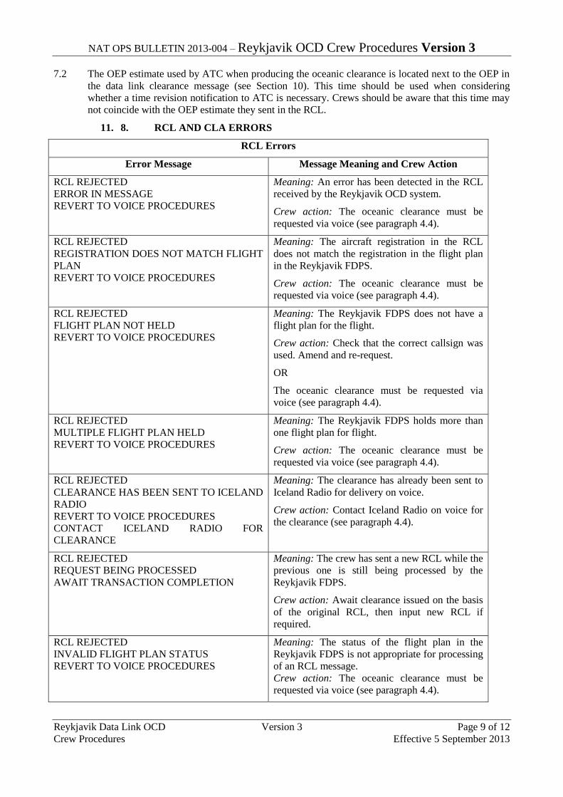
NAT OPS BULLETIN 2013-004 – Reykjavik OCD Crew Procedures Version 3
Reykjavik Data Link OCD Version 3 Page 9 of 12
Crew Procedures Effective 5 September 2013
7.2 The OEP estimate used by ATC when producing the oceanic clearance is located next to the OEP in
the data link clearance message (see Section 10). This time should be used when considering
whether a time revision notification to ATC is necessary. Crews should be aware that this time may
not coincide with the OEP estimate they sent in the RCL.
11. 8. RCL AND CLA ERRORS
RCL Errors
Error Message Message Meaning and Crew Action
RCL REJECTED
ERROR IN MESSAGE
REVERT TO VOICE PROCEDURES
Meaning: An error has been detected in the RCL
received by the Reykjavik OCD system.
Crew action: The oceanic clearance must be
requested via voice (see paragraph 4.4).
RCL REJECTED
REGISTRATION DOES NOT MATCH FLIGHT
PLAN
REVERT TO VOICE PROCEDURES
Meaning: The aircraft registration in the RCL
does not match the registration in the flight plan
in the Reykjavik FDPS.
Crew action: The oceanic clearance must be
requested via voice (see paragraph 4.4).
RCL REJECTED
FLIGHT PLAN NOT HELD
REVERT TO VOICE PROCEDURES
Meaning: The Reykjavik FDPS does not have a
flight plan for the flight.
Crew action: Check that the correct callsign was
used. Amend and re-request.
OR
The oceanic clearance must be requested via
voice (see paragraph 4.4).
RCL REJECTED
MULTIPLE FLIGHT PLAN HELD
REVERT TO VOICE PROCEDURES
Meaning: The Reykjavik FDPS holds more than
one flight plan for flight.
Crew action: The oceanic clearance must be
requested via voice (see paragraph 4.4).
RCL REJECTED
CLEARANCE HAS BEEN SENT TO ICELAND
RADIO
REVERT TO VOICE PROCEDURES
CONTACT ICELAND RADIO FOR
CLEARANCE
Meaning: The clearance has already been sent to
Iceland Radio for delivery on voice.
Crew action: Contact Iceland Radio on voice for
the clearance (see paragraph 4.4).
RCL REJECTED
REQUEST BEING PROCESSED
AWAIT TRANSACTION COMPLETION
Meaning: The crew has sent a new RCL while the
previous one is still being processed by the
Reykjavik FDPS.
Crew action: Await clearance issued on the basis
of the original RCL, then input new RCL if
required.
RCL REJECTED
INVALID FLIGHT PLAN STATUS
REVERT TO VOICE PROCEDURES
Meaning: The status of the flight plan in the
Reykjavik FDPS is not appropriate for processing
of an RCL message.
Crew action: The oceanic clearance must be
requested via voice (see paragraph 4.4).

NAT OPS BULLETIN 2013-004 – Reykjavik OCD Crew Procedures Version 3
Reykjavik Data Link OCD Version 3 Page 10 of 12
Crew Procedures Effective 5 September 2013
RCL REJECTED
RCL SENT TOO EARLY
REQUEST AGAIN LATER
SEND RCL WHEN 25 MINUTES FROM THE
BOUNDARY
Meaning: The flight plan has not yet been
activated in the Reykjavik FDPS (see paragraphs
2.6-2.7).
Crew action: Send the RCL when 25 minutes
from the Reykjavik CTA boundary.
RCL REJECTED
CLEARANCE CANCELLED
REVERT TO VOICE PROCEDURES
TRANSACTION TIMED OUT
Meaning: The transaction has timed out in the
Reykjavik FDPS.
Crew action: The oceanic clearance must be
requested via voice (see paragraph 4.4).
CLA Errors
Error Message Message Meaning and Crew Action
CLA REJECTED
CLEARANCE CANCELLED
REVERT TO VOICE PROCEDURES
Meaning: The CLA received by the Reykjavik
OCD system did not match the data link oceanic
clearance or an error has been detected in the
CLA.
Crew action: The data link oceanic clearance
received by the crew is not valid. The oceanic
clearance must be requested via voice (see
paragraph 4.4).
CLA REJECTED
REGISTRATION DOES NOT MATCH FLIGHT
PLAN
REVERT TO VOICE PROCEDURES
Meaning: The aircraft registration in the CLA
does not match the registration in the flight plan
in the Reykjavik FDPS.
Crew action: The oceanic clearance must be
requested via voice (see paragraph 4.4).
CLA REJECTED
CLEARANCE CANCELLED
REVERT TO VOICE PROCEDURES
TRANSACTION TIMED OUT
Meaning: The transaction has timed out in the
Reykjavik FDPS before the CLA was received.
Crew action: The oceanic clearance must be
requested via voice (see paragraph 4.4).
12. 9. TERMS USED IN THE ATC/ LINE
LEVEL CHANGE The flight level in the clearance is different from the flight
level requested in the RCL message.
MACH CHANGE The speed in the clearance is different from the speed
requested in the RCL message.
ENTRY POINT CHANGE <position> The entry point in the clearance is different from the entry
point requested in the RCL message.
ROUTE AMENDMENT The route in the clearance is different from the route in the
flight plan.
CLEARANCE LIMIT The clearance limit in the clearance is different from the
destination in the flight plan.
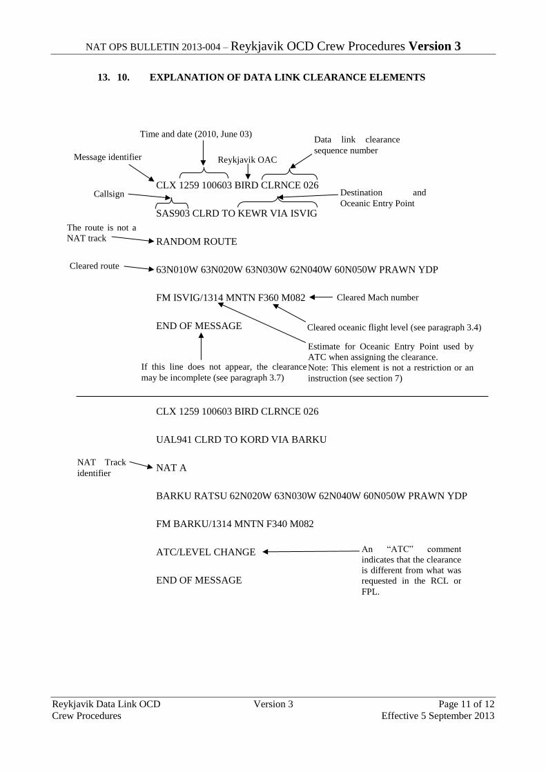
NAT OPS BULLETIN 2013-004 – Reykjavik OCD Crew Procedures Version 3
Reykjavik Data Link OCD Version 3 Page 11 of 12
Crew Procedures Effective 5 September 2013
13. 10. EXPLANATION OF DATA LINK CLEARANCE ELEMENTS
CLX 1259 100603 BIRD CLRNCE 026
SAS903 CLRD TO KEWR VIA ISVIG
RANDOM ROUTE
63N010W 63N020W 63N030W 62N040W 60N050W PRAWN YDP
FM ISVIG/1314 MNTN F360 M082
END OF MESSAGE
CLX 1259 100603 BIRD CLRNCE 026
UAL941 CLRD TO KORD VIA BARKU
NAT A
BARKU RATSU 62N020W 63N030W 62N040W 60N050W PRAWN YDP
FM BARKU/1314 MNTN F340 M082
ATC/LEVEL CHANGE
END OF MESSAGE
Message identifier
The route is not a
NAT track
Time and date (2010, June 03)
Reykjavik OAC
Data link clearance
sequence number
Callsign Destination and
Oceanic Entry Point
Cleared route
An “ATC” comment
indicates that the clearance
is different from what was
requested in the RCL or
FPL.
Cleared Mach number
Cleared oceanic flight level (see paragraph 3.4)
If this line does not appear, the clearance
may be incomplete (see paragraph 3.7)
Estimate for Oceanic Entry Point used by
ATC when assigning the clearance.
Note: This element is not a restriction or an
instruction (see section 7)
NAT Track
identifier

NAT OPS BULLETIN 2013-004 – Reykjavik OCD Crew Procedures Version 3
Reykjavik Data Link OCD Version 3 Page 12 of 12
Crew Procedures Effective 5 September 2013
Abbreviations used in data link oceanic clearance messages
ATC Air Traffic Control
CLRD Cleared
CLRNCE Clearance
CLX Clearance uplink message
F Flight level
FM From
M Mach
MNTN Maintain
NAT North Atlantic Track
END -
NAT OPS Bulletin 2013_002 TrkWise.docx
Serial Number: 2013-002
Subject: “Track Wise”– Targeting Risk within
the Shanwick OCA
Issued: 26 April 2013
The purpose of the North Atlantic Operations Bulletin 2013-002 is to promulgate “Track Wise” – Targeting
Risk within the Shanwick Oceanic Control Area (OCA).
Publication of “Track Wise – Targeting Risk within the Shanwick OCA”
a) In October 2012, National Air Traffic Services (NATS) completed a new publication of an interactive
DVD entitled “Track Wise – Targeting Risk within the Shanwick OCA” This new DVD is produced and
funded by NATS, the ANSP providing air traffic control services in the Shanwick Oceanic Control
Area (OCA), in collaboration with the Safety Partnership Agreement (whose membership includes
airlines based in the United Kingdom, Europe and the United States).
b) The DVD presents the progress of a westbound flight through the Shanwick OCA and while the
operational procedure elements are specific to Shanwick the majority of the DVD considers issues
common to the whole ICAO NAT Region.
c) “Track Wise” is available for free to all interested parties, including aircraft operators, ANSPs,
regulators and professional organizations. The content of the DVD is available on YouTube via the
following link:
http://www.youtube.com/watch?v=EJTjwW5ZYas
d) A link to this video has also been placed on the ICAO EUR/NAT website (www.paris.icao.int) on the
page for NAT Region documents:
http://www.paris.icao.int/documents_open/subcategory.php?id=106
NOTICE NAT Ops Bulletins are used to distribute information on behalf of the North Atlantic Systems Planning
Group (NAT SPG). The material contained therein may be developed within the working structure of the
NAT SPG or be third party documents posted at the request of a NAT SPG Member State. A printed or
electronic copy of this Bulletin, plus any associated documentation, is provided to the recipient as is and
without any warranties as to its description, condition, quality, fitness for purpose or functionality and for use
by the recipient solely for guidance only. The information published by ICAO in this document is made
available without warranty of any kind; the Organization accepts no responsibility or liability whether direct
or indirect, as to the currency, accuracy or quality of the information, nor for any consequence of its use.
The designations and the presentation of material in this publication do not imply the expression of any
opinion whatsoever on the part of ICAO concerning the legal status of any country, territory, city or area of
its authorities, or concerning the delimitation of its frontiers or boundaries.
The NAT OPS Bulletin Checklist available on www.paris.icao.int (EUR & NAT Documents,
NAT Documents), contains an up to date list of all current NAT Ops Bulletins.
There is no objection to the reproduction of extracts of information contained in this Bulletin if the source is
acknowledged.

Serial Number: 2013-001
Subject: Information & Guidance for Data Link
Oceanic Clearance Delivery in Santa Maria FIR
Issued: 28 January 2013
The purpose of the North Atlantic Operations Bulletin 2013-001 is to promulgate Oceanic Clearance
Delivery (OCD) via data link procedures on behalf of the Santa Maria Area Control Centre (OCA) which
was promulgated by NAV Portugal as AIC 009 - 2012 A:
a) An effort was made to assure that the AIC Portugal A009/2012 would only contain information and
guidance for the use of OCD in Santa Maria FIR, reinforcing the need to always verify the applicable
oceanic clearance procedures in AIP Portugal.
b) All procedures related to oceanic clearance request and delivery which were published in AIP Portugal
and duplicated in the AIC have been removed from the AIC and are now only published in AIP
Portugal.
c) A specific attention call was made to pilots for the importance of making use of the waypoints
designators in the data link RCL message instead of the coordinates that make up those waypoints.
For question on data link OCD service and requirements you may contact the following NAV Portugal staff:
Jose Joaquim S.P. Cabral
Head of Atlantic Operational Procedures
NAV Portugal, E.P.E. / Atlantic Operations Directorate
Apartado 47 - 9580-909 Vila do Porto
Phone: +.351.296.820 510 / Fax: +.351.296.886 116
Email: [email protected]
Mobile Phone: +.351.917 338 871
This NAT OPS Bulletin Serial Number: 2013_001 supersedes NAT OPS Bulletin Serial Number: 2010_014
NOTICE
NAT Ops Bulletins are used to distribute information on behalf of the North Atlantic Systems Planning Group
(NAT SPG). The material contained therein may be developed within the working structure of the NAT SPG or
be third party documents posted at the request of a NAT SPG Member State. A printed or electronic copy of this
Bulletin, plus any associated documentation, is provided to the recipient as is and without any warranties as to its
description, condition, quality, fitness for purpose or functionality and for use by the recipient solely for guidance
only. The information published by ICAO in this document is made available without warranty of any kind; the
Organization accepts no responsibility or liability whether direct or indirect, as to the currency, accuracy or
quality of the information, nor for any consequence of its use. The designations and the presentation of material
in this publication do not imply the expression of any opinion whatsoever on the part of ICAO concerning the
legal status of any country, territory, city or area of its authorities, or concerning the delimitation of its frontiers or
boundaries.
The NAT OPS Bulletin Checklist available on www.paris.icao.int (EUR & NAT Documents, NAT Documents),
contains an up to date list of all current NAT Ops Bulletins.
There is no objection to the reproduction of extracts of information contained in this Bulletin if the source is
acknowledged.

1.
AIP AIC: 009 - 2012 APublication Date: 29-Nov-2012
PORTUGAL
OCEANIC CLEARANCE DELIVERY (OCD) IN SANTA MARIA OCEANIC CONTROL AREA (OCA)
Phone: +.351.21.855 35 06
Fax: +.351.21.855 33 99
AFS: LPPPYOYC
Email: [email protected]
Direcção de Segurança e
Desempenho Operacional
Aeronautical Information Service
Apartado 8223
1803-001 Lisboa Codex
1 INTRODUCTIONThe OCD is a data link service that allows pilots and controllers to exchange text messages for oceanic clearance request and oceanic clearance delivery using the ACARS network, according the specifications defined on the AEEC 623 and EUROCAE ED106.
2 PURPOSEThe purpose of this Aeronautical Information Circular (AIC) is to provide information about the NAV Portugal OCD data link service in Santa Maria OCA.
3 AREA OF APPLICATIONSanta Maria Oceanic Control Area (OCA).
4 GENERAL4.1 System descriptionThe implementation of the data link based OCL application consists in the transposition of the oceanic clearance request dialogue, from the HF radio channel to the ACARS data link channel as follows:
• According to the procedures and time frames published in AIP Portugal, the pilot requests his OCL through the ACARS terminal using the Request Oceanic Clearance (RCL) message. The RCL message includes the same information elements as a voice request.
• The ATC ground system will acknowledge the reception of the request and verify that it corresponds to an existing flight plan. If negative, a message will be sent, rejecting the RCL.
• If the flight plan exists the ATC ground system issues the oceanic clearance and sends it to the pilot via the ACARS data link network. The pilot can check and print the clearance at his convenience.
• The pilot sends back a clearance data link acknowledgment (full read-back).
• The read-back is checked by the ATC ground system against the issued clearance and sends either a clearance confirmation or cancellation, depending on the result.
The set of messages defined by AEEC 623 and EUROCAE ED106 for OCL data link messages exchange are:
• RCL for OCL request (downlink)
• CLX for OCL clearance (uplink)
• CLA for OCL read-back (downlink)
• FSM for ACCEPTED, RECEIVED or REJECTED messages (uplink)

2.
4.2 Connecting to System• Each operator of flights that can downlink RCL and CLA messages should ensure that flight crews know
how to address them to Santa Maria's OACC OCD system.
• To establish contact with Santa Maria FIR through OCD data link service, pilots must use the ICAO four letters designator LPPO.
4.3 Requesting ClearanceFlights so equipped should request the clearance by sending the ACARS RCL within the time frames and procedures defined in AIP Portugal.
Pilots entering Santa Maria FIR through one of the waypoints published in AIP Portugal, are reminded to always make use of the appropriate 5 letter designator in the ACARS RCL messages and not the coordinates that make up that waypoint.
4.4 Clearance delivery• Pilots are responsible for checking all items of received oceanic clearance (CLX) and ensure that they are
consistent with the filed Flight Plan and with the oceanic clearance request made by them. If any discrepancy is found, the crew must not send the CLA message and should revert to voice.
• Attention is called to the possibility of the CLX message containing additional information, prefixed with the text “ATC/“. This may be advisory information e.g. “LEVEL CHANGE” or additional ATC instructions e.g. “AT <position> CLIMB/DESCEND TO AND MAINTAIN <level>.
• Pilots must be aware that the Oceanic Clearance is valid only from the oceanic entry point. Usually if there is any difference between the cleared routes and level on the oceanic clearance and the flight’s actual profile, ATC units will coordinate among them in order to correct the flight’s profiles before it reaches the oceanic entry point. If there is a concern, crews should contact their current ATC unit for instructions.
4.5 Clearance negotiation• After clearance delivery and confirmation, flights may submit new requests, by sending again an RCL.
• All subsequent messages will follow the same pattern as the previous RCL.
4.6 Reclearances• When a data link oceanic clearance is amended, it will include the ATC/ line and the RECLEAREANCE
line.
• The ATC/ line will list which item (or items) of the clearance was changed from the previously issued clearance.
• The RECLEARANCE line will contain a number from 1 to 9, to identify the first and subsequent re-clearances (i.e., RECLEARANCE1, RECLEARANCE2, etc.).
• If more than one RECLEAREANCE is received, the CLA should be sent only for the clearance with the highest RECLEAREANCE number.
• If any doubts arise, pilots should revert to voice communications and confirm their clearance.
4.7 Clearance Acknowledgement • When a valid data link oceanic clearance is received, pilots must send a Clearance Acknowledgement
(CLA).
• After sending the CLA the crew should expect a confirmation message from ATC ground system.
• If no confirmation is received within 5 minutes of sending the CLA, then the data link oceanic clearance must be verified via voice.

3.
4.8 Time revisions• If the data link oceanic clearance has been received, crews should advise ATC if the ETA for the boundary
changes by 3 minutes or more.
• Time revisions may be transmitted on voice or by a new data link RCL, containing the revised ETA/ETD.
• If the time revision is made via data link, the crew should expect to receive a Reclearance showing the revised ETA. This may be a copy of the original CLX (containing the new ETA) or the CLX may contain a change in any clearance parameter (accompanied by appropriate information on the ATC/ field).
• All reclearances must be acknowledged.
4.9 Examples of uplink FSM error messages
Pilots are reminded that there might be other FSM messages than those exemplified above. In all circumstances, should any doubts arise, revert to voice procedures.
5 ADDITIONAL INFORMATION AND PARTICIPATION REQUIREMENTSFor more information on OCD data link service and participation requirements you may contact the following NAV Portugal staff:
Post: Jose Joaquim S.P. CabralHead of Atlantic Operational ProceduresAtlantic Operations DirectorateNAV Portugal, E.P.E.Apartado 479580-909 Vila do Porto
Phone: +.351.296.820 510
Phone: Mobile Phone: +.351.917 338 871
Fax: +.351.296.886 116Email: [email protected]
This Aeronautical Information Circular replaces AIC 006-2010 = END =
1 Error is detected in a message: <RCL> REJECTED - ERROR IN MESSAGE - REVERT TO VOICE PROCEDURE
2 RCL is received while another has not been completed: RCL REJECTED - REQUEST BEING PROCESSED - AWAIT TRANSACTION COMPLETION
3 RCL for non-existent flight: RCL REJECTED - FLIGHT PLAN NOT HELD - REVERT TO VOICE PROCEDURE
4 RCL for duplicate flight: RCL REJECTED - FLIGHT PLAN NOT HELD - REVERT TO VOICE PROCEDURE - MULTIPLE FLIGHT PLAN
5 Incorrect entry point in RCL: RCL REJECTED - FLIGHT PLAN NOT HELD - REVERT TO VOICE PROCEDURE
6 No CLX associated to received CLA, or multiple CLA messages: CLA REJECTED - CLEARANCE CANCELLED - REVERT TO VOICE PROCEDURE
7 Invalid checking between CLA and the CLX previously sent (includes mismatch of Re-clearance Number): CLA REJECTED - CLEARANCE CANCELLED - REVERT TO VOICE PROCEDURE
8 Non reception of CLA for a sent CLX within the time T1 (VSP): CLA REJECTED - CLEARANCE CANCELLED - REVERT TO VOICE PROCEDURE - TRANSACTION TIMEOUT
9 When the controller cancels OCL data link clearance manually (from Working window or strip), the system will disable OCD. If subsequently a CLA is received, the system will send an FSM: CLA REJECTED - CLEARANCE CANCELLED - REVERT TO VOICE PROCEDURE

THIS PAGE INTENTIONALLY LEFT BLANK
4.

Serial Number: 2012-031
Subject: NAT Region Data Link Mandate Issued: 30 November 2012
The purpose of North Atlantic Operations Bulletin 2012-031 is to provide airspace users with information
concerning the implementation of the NAT Region Data Link Mandate. Phase 1 of the Mandate becomes
effective on 7 February 2013.
Canada, Iceland, Portugal and the United Kingdom have issued Aeronautical Information Circulars (AIC)
concerning the initial implementation of the NAT Region Data Link Mandate. Through prior coordination,
all of the AICs include the same content. The AIC issued by Portugal is provided in this Bulletin.
The United States has issued an FAA Notice on the same subject. The FAA Notice is also included in this
Bulletin.
Questions or requests for further information concerning the content of the AICs or the FAA Notice should
be directed as follows:
Canada (AIC 40/12 - 13 December 2012)
Doug Dillon, Manager
ACC Operations, Gander Area Control Centre
NAV CANADA
P.O. Box 328
Gander, NL A1V 1W7
Direct line: 709-651-5223
E-mail: [email protected]
Iceland (AIC A 012/2012 - 14 Dec 2012)
E-mail:[email protected]
Portugal (AIP AIC 008-2012 A - 29 Nov 2012)
Cirilo Araújo
Head of Air Traffic Services, Santa Maria FIR
NAV Portugal E.P.E.
Phone:+351 296 820 504
Email:[email protected]
United Kingdom (AIC Y 145/2012 - 20 Dec 2012)
General Manager, Prestwick Centre
NATS
Fresson Avenue
PRESTWICK
KA9 2GX
Direct line: 0044-1292-479800
United States (FAA Notice North Atlantic FANS 1/A
Data Link Mandate - 18 October 2012)
Greg Sparks Flight Standards Service,
Performance Based Flight Systems Branch (AFS-
470),
Program Support; EIS, Inc.
202-385-4987 [email protected]
Mark Patterson
AFS-470
202-385-4352
Roy Grimes AFS-470 Program Support
CSSI, Inc.
202-863-3692
Madison Walton
AFS-470
202-385-4596
NOTICE
NAT Ops Bulletins are used to distribute information on behalf of the North Atlantic Systems Planning
Group (NAT SPG). The material contained therein may be developed within the working structure of the
NAT SPG or be third party documents posted at the request of a NAT SPG Member State. A printed or
electronic copy of this Bulletin, plus any associated documentation, is provided to the recipient as is and
without any warranties as to its description, condition, quality, fitness for purpose or functionality and for use
by the recipient solely for guidance only. The information published by ICAO in this document is made
available without warranty of any kind; the Organization accepts no responsibility or liability whether direct
or indirect, as to the currency, accuracy or quality of the information, nor for any consequence of its use.
The designations and the presentation of material in this publication do not imply the expression of any
opinion whatsoever on the part of ICAO concerning the legal status of any country, territory, city or area of
its authorities, or concerning the delimitation of its frontiers or boundaries.
The NAT OPS Bulletin Checklist available on www.paris.icao.int (EUR & NAT Documents,
NAT Documents), contains an up to date list of all current NAT Ops Bulletins.
There is no objection to the reproduction of extracts of information contained in this Bulletin if the source is
acknowledged.

AIP AIC: 008 - 2012 APublication Date: 29-Nov-2012
PORTUGAL
NOTICE OF MANDATE FOR DATA LINK SERVICES IN THE NORTH ATLANTIC REGION
Phone: +.351.21.855 35 06
Fax: +.351.21.855 33 99
AFS: LPPPYOYC
Email: [email protected]
A
Direcção de Segurança e
Desempenho Operacional
eronautical Information Service
Apartado 8223
1803-001 Lisboa Codex
1. INTRODUCTION
It is widely acknowledged that data link services enhance surveillance and intervention capabilities, and its availability constitutes a crucial component in providing safe, efficient and sustainable operations, as well as facilitating the future evolution of the air traffic management (ATM) system in the North Atlantic (NAT) region.
As notified in State letter EUR/NAT 12-0003.TEC (dated 04 January 2012), all aircraft intending to conduct flights in the portions of the North Atlantic (NAT) regional airspace defined below shall be fitted with, and shall operate Controller Pilot Data Link Communications (CPDLC) and Automatic Dependent Surveillance–Contract (ADS-C) equipment.
2. PURPOSE OF CIRCULAR
This aeronautical information circular (AIC) outlines the defined airspace for the data link mandate, methods of indicating equipage in flight plan, and details the time lines for implementation.
3. BACKGROUND
The CPDLC and ADS-C implementation based on RTCA DO-258A/EUROCAE ED-100A (or ED-100) avionics standards started in the ICAO NAT Region at the end of 1990. Data link service enhances ATM surveillance and intervention capabilities and is seen as instrumental in reducing collision risk, particularly in the vertical plane, and meeting the NAT Target Level of Safety (TLS). The use of ADS-C vertical and horizontal deviation event contracts to conformance monitor aircraft help towards quickly resolving this significant safety issue.
The use of ADS-C would also greatly facilitate search and rescue operations and location of an aircraft following an accident in oceanic airspace.
In order to achieve the foregoing safety objectives, it is important to increase the level of data link equipage in the NAT. The current level of data link usage in the NAT has reached 45-50% and continues to grow. Introducing mandatory data link equipment carriage requirement will increase the NAT data link equipage level and help in meeting the NAT TLS.
1.
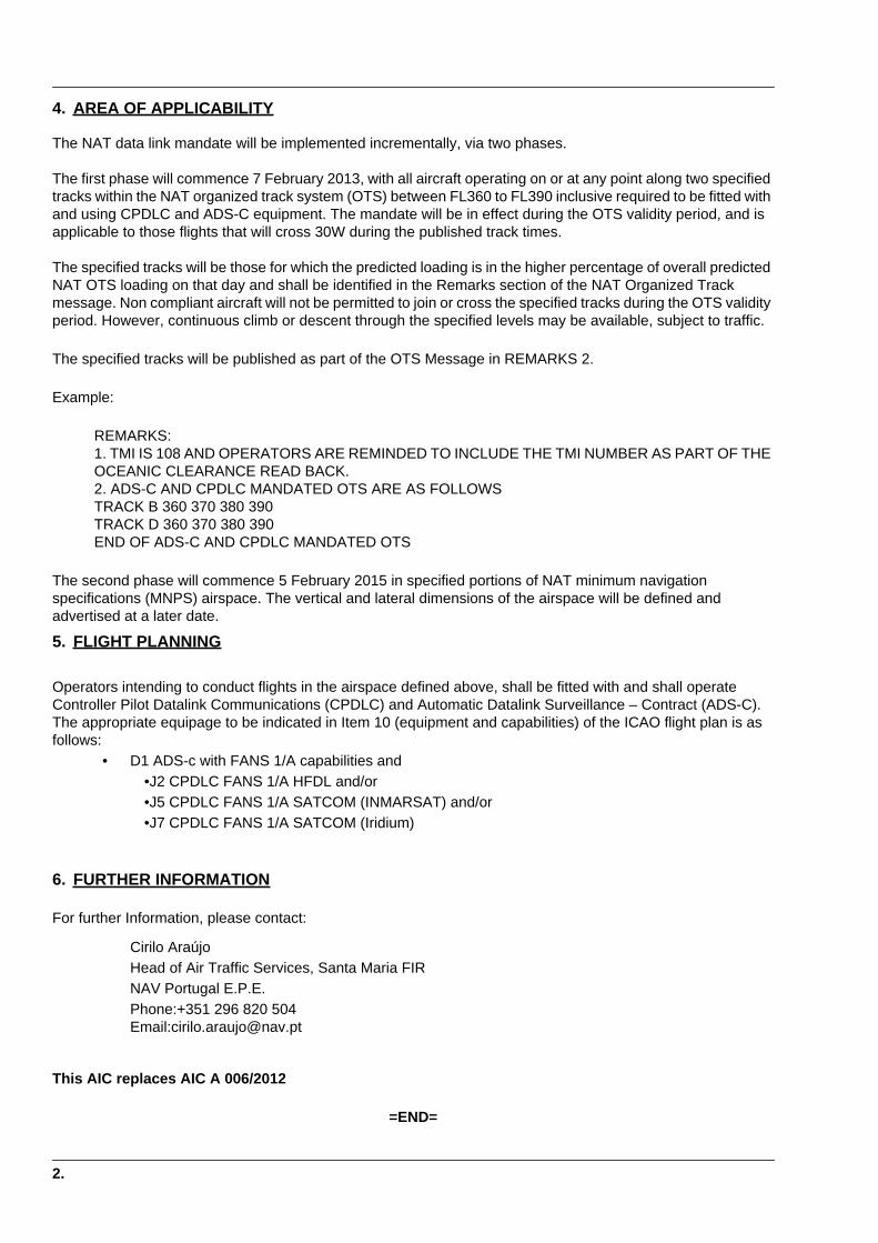
4. AREA OF APPLICABILITY
The NAT data link mandate will be implemented incrementally, via two phases.
The first phase will commence 7 February 2013, with all aircraft operating on or at any point along two specified tracks within the NAT organized track system (OTS) between FL360 to FL390 inclusive required to be fitted with and using CPDLC and ADS-C equipment. The mandate will be in effect during the OTS validity period, and is applicable to those flights that will cross 30W during the published track times.
The specified tracks will be those for which the predicted loading is in the higher percentage of overall predicted NAT OTS loading on that day and shall be identified in the Remarks section of the NAT Organized Track message. Non compliant aircraft will not be permitted to join or cross the specified tracks during the OTS validity period. However, continuous climb or descent through the specified levels may be available, subject to traffic.
The specified tracks will be published as part of the OTS Message in REMARKS 2.
Example:
REMARKS:1. TMI IS 108 AND OPERATORS ARE REMINDED TO INCLUDE THE TMI NUMBER AS PART OF THE OCEANIC CLEARANCE READ BACK.2. ADS-C AND CPDLC MANDATED OTS ARE AS FOLLOWSTRACK B 360 370 380 390TRACK D 360 370 380 390END OF ADS-C AND CPDLC MANDATED OTS
The second phase will commence 5 February 2015 in specified portions of NAT minimum navigation specifications (MNPS) airspace. The vertical and lateral dimensions of the airspace will be defined and advertised at a later date.
5. FLIGHT PLANNING
Operators intending to conduct flights in the airspace defined above, shall be fitted with and shall operate Controller Pilot Datalink Communications (CPDLC) and Automatic Datalink Surveillance – Contract (ADS-C). The appropriate equipage to be indicated in Item 10 (equipment and capabilities) of the ICAO flight plan is as follows:
• D1 ADS-c with FANS 1/A capabilities and •J2 CPDLC FANS 1/A HFDL and/or •J5 CPDLC FANS 1/A SATCOM (INMARSAT) and/or •J7 CPDLC FANS 1/A SATCOM (Iridium)
6. FURTHER INFORMATION
For further Information, please contact:
Cirilo AraújoHead of Air Traffic Services, Santa Maria FIRNAV Portugal E.P.E.Phone:+351 296 820 504Email:[email protected]
This AIC replaces AIC A 006/2012
=END=
2.
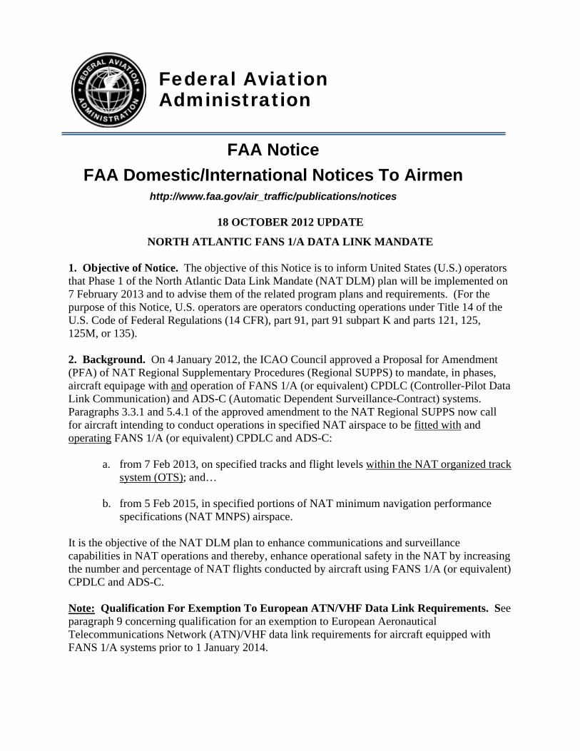
Federal Aviation Administration
FAA Notice FAA Domestic/International Notices To Airmen
http://www.faa.gov/air_traffic/publications/notices
18 OCTOBER 2012 UPDATE
NORTH ATLANTIC FANS 1/A DATA LINK MANDATE 1. Objective of Notice. The objective of this Notice is to inform United States (U.S.) operators that Phase 1 of the North Atlantic Data Link Mandate (NAT DLM) plan will be implemented on 7 February 2013 and to advise them of the related program plans and requirements. (For the purpose of this Notice, U.S. operators are operators conducting operations under Title 14 of the U.S. Code of Federal Regulations (14 CFR), part 91, part 91 subpart K and parts 121, 125, 125M, or 135). 2. Background. On 4 January 2012, the ICAO Council approved a Proposal for Amendment (PFA) of NAT Regional Supplementary Procedures (Regional SUPPS) to mandate, in phases, aircraft equipage with and operation of FANS 1/A (or equivalent) CPDLC (Controller-Pilot Data Link Communication) and ADS-C (Automatic Dependent Surveillance-Contract) systems. Paragraphs 3.3.1 and 5.4.1 of the approved amendment to the NAT Regional SUPPS now call for aircraft intending to conduct operations in specified NAT airspace to be fitted with and operating FANS 1/A (or equivalent) CPDLC and ADS-C:
a. from 7 Feb 2013, on specified tracks and flight levels within the NAT organized track system (OTS); and…
b. from 5 Feb 2015, in specified portions of NAT minimum navigation performance
specifications (NAT MNPS) airspace. It is the objective of the NAT DLM plan to enhance communications and surveillance capabilities in NAT operations and thereby, enhance operational safety in the NAT by increasing the number and percentage of NAT flights conducted by aircraft using FANS 1/A (or equivalent) CPDLC and ADS-C. Note: Qualification For Exemption To European ATN/VHF Data Link Requirements. See paragraph 9 concerning qualification for an exemption to European Aeronautical Telecommunications Network (ATN)/VHF data link requirements for aircraft equipped with FANS 1/A systems prior to 1 January 2014.

23. NAT DLM Implementation Plan – Phase 1 (7 February 2013). a. The ICAO NAT SPG (North Atlantic System Planning Group) has agreed that for the 7 February 2013 phase of the DLM implementation plan, carriage and operation of FANS 1/A (or equivalent) data link systems will be mandatory:
(1) Between flight levels 360-390 (inclusive) on no more than two NAT Organized Track System (OTS) tracks that are identified in the Remarks section of the NAT OTS message. (See example OTS message below).
(2) During the OTS validity period and will apply to those flights crossing 30 degrees west
longitude during the published track times. b. Aircraft that are not equipped and using FANS 1/A data link will not be permitted to join or cross the specified tracks during the OTS validity period. For such aircraft, however, continuous climb or descent through the specified levels may be available, subject to traffic. Note 1: NAT SPG has agreed that the two OTS tracks where the DLM will apply will be established with the provision that at an OTS Track where the requirements of the DLM will not apply will be made available one degree north and one degree south of the specified DLM tracks. Note 2: normally the two specified DLM tracks will be adjacent to each other in the OTS. 4. Example NAT Organized Track Message, Remarks section. The specified tracks will be published as part of the OTS Message in REMARKS 2. An example is shown below: REMARKS: 1. TMI IS 108 AND OPERATORS ARE REMINDED TO INCLUDE THE TMI NUMBER AS PART OF THE OCEANIC CLEARANCE READ BACK. 2. ADS-C AND CPDLC MANDATED OTS ARE AS FOLLOWS TRACK B 360 370 380 390 TRACK D 360 370 380 390
END OF ADS-C AND CPDLC MANDATED OTS
5. Required Flight Plan Entries. a. Operators planning to operate in NAT airspace where the DLM is applied shall indicate FANS 1/A (or equivalent) CPDLC communications and ADS-C surveillance capabilities in the ICAO flight plan in accordance with ICAO Document 4444 (Air Traffic Management), Appendix 2 (Flight Plan). In addition, operators are reminded of the NAT SUPPS, Chapter 2 requirement that all aircraft intending to operate in the NAT Region shall insert the aircraft registration in Item 18 of the ICAO flight plan, following the “REG/” indicator.
b. The appropriate equipage to be indicated in Item 10 (equipment and capabilities) of the ICAO flight plan is as follows:
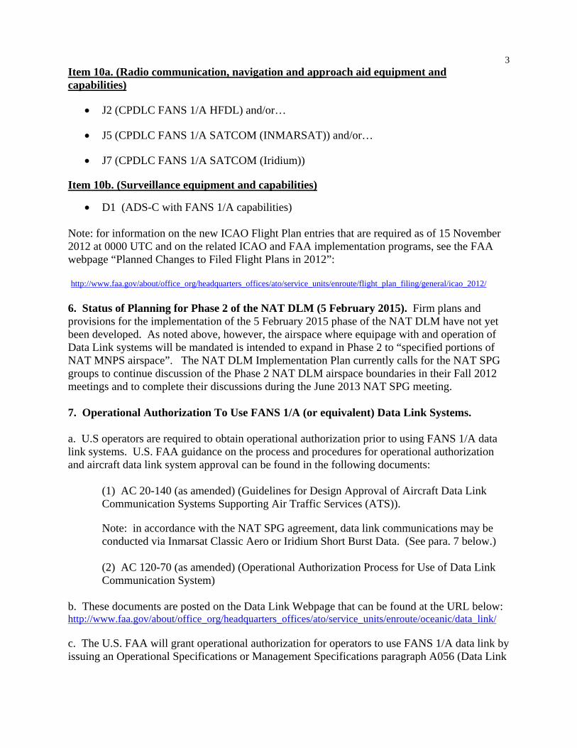
3Item 10a. (Radio communication, navigation and approach aid equipment and capabilities)
J2 (CPDLC FANS 1/A HFDL) and/or…
J5 (CPDLC FANS 1/A SATCOM (INMARSAT)) and/or…
J7 (CPDLC FANS 1/A SATCOM (Iridium))
Item 10b. (Surveillance equipment and capabilities)
D1 (ADS-C with FANS 1/A capabilities) Note: for information on the new ICAO Flight Plan entries that are required as of 15 November 2012 at 0000 UTC and on the related ICAO and FAA implementation programs, see the FAA webpage “Planned Changes to Filed Flight Plans in 2012”: http://www.faa.gov/about/office_org/headquarters_offices/ato/service_units/enroute/flight_plan_filing/general/icao_2012/ 6. Status of Planning for Phase 2 of the NAT DLM (5 February 2015). Firm plans and provisions for the implementation of the 5 February 2015 phase of the NAT DLM have not yet been developed. As noted above, however, the airspace where equipage with and operation of Data Link systems will be mandated is intended to expand in Phase 2 to “specified portions of NAT MNPS airspace”. The NAT DLM Implementation Plan currently calls for the NAT SPG groups to continue discussion of the Phase 2 NAT DLM airspace boundaries in their Fall 2012 meetings and to complete their discussions during the June 2013 NAT SPG meeting. 7. Operational Authorization To Use FANS 1/A (or equivalent) Data Link Systems. a. U.S operators are required to obtain operational authorization prior to using FANS 1/A data link systems. U.S. FAA guidance on the process and procedures for operational authorization and aircraft data link system approval can be found in the following documents:
(1) AC 20-140 (as amended) (Guidelines for Design Approval of Aircraft Data Link Communication Systems Supporting Air Traffic Services (ATS)).
Note: in accordance with the NAT SPG agreement, data link communications may be conducted via Inmarsat Classic Aero or Iridium Short Burst Data. (See para. 7 below.) (2) AC 120-70 (as amended) (Operational Authorization Process for Use of Data Link Communication System)
b. These documents are posted on the Data Link Webpage that can be found at the URL below: http://www.faa.gov/about/office_org/headquarters_offices/ato/service_units/enroute/oceanic/data_link/ c. The U.S. FAA will grant operational authorization for operators to use FANS 1/A data link by issuing an Operational Specifications or Management Specifications paragraph A056 (Data Link
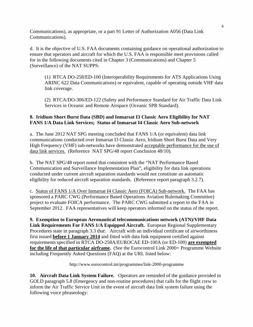
4Communications), as appropriate, or a part 91 Letter of Authorization A056 (Data Link Communications). d. It is the objective of U.S. FAA documents containing guidance on operational authorization to ensure that operators and aircraft for which the U.S. FAA is responsible meet provisions called for in the following documents cited in Chapter 3 (Communications) and Chapter 5 (Surveillance) of the NAT SUPPS:
(1) RTCA DO-258/ED-100 (Interoperability Requirements for ATS Applications Using ARINC 622 Data Communications) or equivalent, capable of operating outside VHF data link coverage.
(2) RTCA/DO-306/ED-122 (Safety and Performance Standard for Air Traffic Data Link Services in Oceanic and Remote Airspace (Oceanic SPR Standard).
8. Iridium Short Burst Data (SBD) and Inmarsat I3 Classic Aero Eligibility for NAT FANS 1/A Data Link Services; Status of Inmarsat I4 Classic Aero Sub-network a. The June 2012 NAT SPG meeting concluded that FANS 1/A (or equivalent) data link communications conducted over Inmarsat I3 Classic Aero, Iridium Short Burst Data and Very High Frequency (VHF) sub-networks have demonstrated acceptable performance for the use of data link services. (Reference NAT SPG/48 report Conclusion 48/10). b. The NAT SPG/48 report noted that consistent with the “NAT Performance Based Communication and Surveillance Implementation Plan”, eligibility for data link operations conducted under current aircraft separation standards would not constitute an automatic eligibility for reduced aircraft separation standards. (Reference report paragraph 3.2.7). c. Status of FANS 1/A Over Inmarsat I4 Classic Aero (FOICA) Sub-network. The FAA has sponsored a PARC CWG (Performance Based Operations Aviation Rulemaking Committee) project to evaluate FOICA performance. The PARC CWG submitted a report to the FAA in September 2012. FAA representatives will keep operators informed on the status of the report. 9. Exemption to European Aeronautical telecommunications network (ATN)/VHF Data Link Requirements For FANS 1/A Equipped Aircraft. European Regional Supplementary Procedures state in paragraph 3.3 that: Aircraft with an individual certificate of airworthiness first issued before 1 January 2014 and fitted with data link equipment certified against requirements specified in RTCA DO-258A/EUROCAE ED-100A (or ED-100) are exempted for the life of that particular airframe. (See the Eurocontrol Link 2000+ Programme Website including Frequently Asked Questions (FAQ) at the URL listed below:
http://www.eurocontrol.int/programmes/link-2000-programme 10. Aircraft Data Link System Failure. Operators are reminded of the guidance provided in GOLD paragraph 5.8 (Emergency and non-routine procedures) that calls for the flight crew to inform the Air Traffic Service Unit in the event of aircraft data link system failure using the following voice phraseology:

5 Flight crew DATA LINK FAILED.
SELECTING ATC COMM OFF. CONTINUING ON VOICE
Controller ROGER. CONTINUE ON VOICE In addition, the flight crew should continue to use voice until the functionality of the aircraft system can be re-established. 11. Reference Document. NAV CANADA Aeronautical Information Circular 24/12 (Notice of Mandate For Data Link Services In The North Atlantic Region) (28 June 2012) was consulted when developing this Notice). 12. Contacts. If there are questions on this Notice, please contact one of the following:
Name Organization Phone Email Greg Sparks Flight Standards Service,
Performance Based Flight Systems Branch (AFS-470), Program Support; EIS, Inc.
202-385-4987 [email protected]
Roy Grimes AFS-470 Program Support CSSI, Inc.
202-863-3692 [email protected];
Mark Patterson AFS-470 202-385-4352 [email protected]; Madison Walton
AFS-470 202-385-4596 [email protected];
(Performance Based Flight Systems Branch, AFS-470, 10/18/12)
NAT OPS Bulletin 2012-030.docx
Serial Number: 2012-030
Subject: Reduced Longitudinal Separation
Minimum (RLongSM) Trial
Effective: 17 September 2012
The purpose of North Atlantic Operations Bulletin 2012-030 is to promulgate information, published by the
United States’ Federal Aviation Administration (FAA) concerning the RLongSM validation trial taking place
in the Gander and Shanwick Oceanic Control Areas (OCA).
Contact person: Dennis Mills, New Program Implementation and International Support Branch, AFS-240
Telephone: +202 493-4901
NOTICE NAT Ops Bulletins are used to distribute information on behalf of the North Atlantic Systems Planning
Group (NAT SPG). The material contained therein may be developed within the working structure of the
NAT SPG or be third party documents posted at the request of a NAT SPG Member State. A printed or
electronic copy of this Bulletin, plus any associated documentation, is provided to the recipient as is and
without any warranties as to its description, condition, quality, fitness for purpose or functionality and for use
by the recipient solely for guidance only. The information published by ICAO in this document is made
available without warranty of any kind; the Organization accepts no responsibility or liability whether direct
or indirect, as to the currency, accuracy or quality of the information, nor for any consequence of its use.
The designations and the presentation of material in this publication do not imply the expression of any
opinion whatsoever on the part of ICAO concerning the legal status of any country, territory, city or area of
its authorities, or concerning the delimitation of its frontiers or boundaries.
The NAT OPS Bulletin Checklist available on www.paris.icao.int (EUR & NAT Documents,
NAT Documents), contains an up to date list of all current NAT Ops Bulletins.
There is no objection to the reproduction of extracts of information contained in this Bulletin if the source is
acknowledged.
NAT OPS BULLETIN 2012-030 – Reduced Longitudinal Separation Minimum (RLongSM) Trial
NAT OPS Bulletin 2012-030.docx
- END -
Serial Number: 2012-027
Subject: Trial of a Five-Minute Along-Track
Longitudinal Separation Minimum in the
Gander Oceanic Control Area
Effective: 03 May 2012
The purpose of North Atlantic Operations Bulletin 2012-027 is to promulgate information concerning a trial
application of five-minute along-track longitudinal separation minimum in the Gander OCA on behalf of
NAV CANADA, the air navigation services provider for Canada.
This information is promulgated by Canada as AIC 17/12, and is effective 03 May 2012.
For question concerning AIC 17/12, please contact:
Doug Dillon
Manager, ACC Operations, Gander Area Control Centre
NAV CANADA
P.O. Box 328
Gander, NL A1V-1W7
Direct line: 709-651-5223
E-mail: [email protected]
NOTICE NAT Ops Bulletins are used to distribute information on behalf of the North Atlantic Systems Planning
Group (NAT SPG). The material contained therein may be developed within the working structure of the
NAT SPG or be third party documents posted at the request of a NAT SPG Member State. A printed or
electronic copy of this Bulletin, plus any associated documentation, is provided to the recipient as is and
without any warranties as to its description, condition, quality, fitness for purpose or functionality and for use
by the recipient solely for guidance only. The information published by ICAO in this document is made
available without warranty of any kind; the Organization accepts no responsibility or liability whether direct
or indirect, as to the currency, accuracy or quality of the information, nor for any consequence of its use.
The designations and the presentation of material in this publication do not imply the expression of any
opinion whatsoever on the part of ICAO concerning the legal status of any country, territory, city or area of
its authorities, or concerning the delimitation of its frontiers or boundaries.
The NAT OPS Bulletin Checklist available on www.paris.icao.int (EUR & NAT Documents,
NAT Documents), contains an up to date list of all current NAT Ops Bulletins.
There is no objection to the reproduction of extracts of information contained in this Bulletin if the source is
acknowledged.

3 MAY 12
Note: Cette information est aussi disponible dans l’autre langue officielle. Page 1 of 2
AERONAUTICAL INFORMATION
CIRCULAR 17/12
TRIAL OF A FIVE-MINUTE ALONG-TRACK LONGITUDINAL SEPARATION MINIMUM IN THE GANDER OCEANIC CONTROL
AREA
(Supersedes AIC 42/11)
Introduction
On 28 March 2011, as part of a program to improve service provision in North Atlantic (NAT) airspace, Gander area control centre (ACC) commenced participation in the trial of a five-minute longitudinal separation minimum to be applied between eligible aircraft pairs operating within the Gander and Shanwick oceanic control areas (OCAs).
The five-minute longitudinal separation minimum is intended to aid in the provision of optimum vertical profiles, by means of mid-ocean flight level changes, for those suitably equipped aircraft. Application of this separation minimum is predicated on the use of Automatic Dependent Surveillance—Contract (ADS-C) periodic reports, which provide air traffic control (ATC) with increased confidence in aircraft position reports and estimates, and direct controller pilot–communications (DCPC) provided via controller–pilot data link communications (CPDLC).
NAT MNPS Longitudinal Separation
The current longitudinal separation minimum applied in NAT minimum navigation performance specifications (MNPS) between turbojet aircraft pairs on the same track is 15 minutes, which may be reduced to 10 minutes using the Mach number technique. All aircraft pairs, including those eligible for the five-minute separation, are required to be separated by one of these minima prior to entry into NAT MNPS airspace.
The five-minute longitudinal separation minimum becomes available once eligible aircraft have
entered the Gander or Shanwick OCA, and ADS-C and CPDLC connections have been established. For this reason, it is imperative that pilots request mid-ocean flight level changes from ATC, if it is determined that such changes might result in a more fuel-efficient flight profile.
Operator Participation
Operators do not need to apply to be part of the trial and will be eligible for participation provided they have an ADS-C and CPDLC log-on with Gander ACC and possess MNPS approval. Application of this specific procedure by ATC will be transparent to flights that have received an altitude change clearance.
Flight crews must
adhere to the ATC cleared Mach number; and
report any failure or malfunction of their global positioning system (GPS), ADS-C, or CPDLC equipment to ATC as soon as it becomes apparent.
There will be no changes to the applicable Strategic Lateral Offset Procedure (SLOP).
3 MAY 12
Page 2 of 2 AERONAUTICAL INFORMATION CIRCULAR 17/12
Trial Period
The trial is scheduled to run until March 2014, after which time a review will be performed and a decision will be announced regarding future plans for the five-minute longitudinal separation minimum.
Further Information
For further Information, please contact:
Doug Dillon, Manager ACC Operations, Gander Area Control Centre NAV CANADA P.O. Box 328 Gander, NL A1V 1W7
Direct line: 709-651-5223 E-mail: [email protected]
Serial Number: 2012-026
Subject: Trial of a 5 Minute Along Track
Longitudinal Separation in the Shanwick
OCA.
Issued: 16 March 2012
The purpose of North Atlantic Operations Bulletin 2012-026 is to promulgate information concerning a trial
of a 5 minute along track longitudinal separation in the Shanwick Oceanic Control Area which commenced
30 March 2011.
A time extension to the trial period by 24 months, or until publication of the new global standards relating to
RLongSM, has been agreed.
This original information was promulgated by United Kingdom as AIC: Y 006/2011, which was effective
24 February 2011, and which will be updated with an AIC during the next AIRAC cycle.
For questions concerning AIC Y 006/2011 please contact:
Duty Shanwick ATC Supervisor
Telephone: +44 1294 655141
E-mail: [email protected]
NOTICE NAT Ops Bulletins are used to distribute information on behalf of the North Atlantic Systems Planning
Group (NAT SPG). The material contained therein may be developed within the working structure of the
NAT SPG or be third party documents posted at the request of a NAT SPG Member State. A printed or
electronic copy of this Bulletin, plus any associated documentation, is provided to the recipient as is and
without any warranties as to its description, condition, quality, fitness for purpose or functionality and for use
by the recipient solely for guidance only. The information published by ICAO in this document is made
available without warranty of any kind; the Organization accepts no responsibility or liability whether direct
or indirect, as to the currency, accuracy or quality of the information, nor for any consequence of its use.
The designations and the presentation of material in this publication do not imply the expression of any
opinion whatsoever on the part of ICAO concerning the legal status of any country, territory, city or area of
its authorities, or concerning the delimitation of its frontiers or boundaries.
The NAT OPS Bulletin Checklist available on www.paris.icao.int (EUR & NAT Documents,
NAT Documents), contains an up to date list of all current NAT Ops Bulletins.
There is no objection to the reproduction of extracts of information contained in this Bulletin if the source is
acknowledged.
1.
UNITED KINGDOMAERONAUTICAL INFORMATION
CIRCULAR
AIC: Y 006/201124-FEB-2011
Operational
INTRODUCTION OF A TRIAL OF A 5 MINUTE ALONG TRACK LONGITUDINAL SEPARATION IN THE SHANWICK OCA(COMMENCING 30 MARCH 2011).
NATS LtdUK Aeronautical Information ServiceHeathrow HouseBath RoadHounslow, Middlesex TW5 9ATURL: http://www.ais.org.ukPhone: 020-8750 3779 (Editorial)Phone: 0870-8871410 (Distribution - Tangent Direct)Phone: 01292-692527 (Content - NATS/Procedures and Developments)
1 Introduction
1.1 The current longitudinal separation minimum applied in North Atlantic (NAT) Airspace, for MNPS approved aircraft pairs followingthe same track, is 15 minutes which may be reduced to 10 minutes using the Mach number technique.
1.2 As part of a programme to improve service provision in NAT Airspace, on 30 March 2011, a trial of a 5 minute, separation minimumwill commence, between aircraft which are following the same track, irrespective of whether they are East or Westbound. The applicationof this minimum is intended to aid the provision of optimum vertical profiles for suitably equipped aircraft, and is based on the use of ADS-Cperiodic reports which will provide ATC with increased confidence in aircraft position reports and estimates.
2 Qualification to participate in the Trial and subsequent full implementation
2.1 Operators will be required to have an ADS-C contract with Shanwick, posses MNPS approval and utilise CPDLC communications.Only aircraft pairs meeting these requirements will be considered by ATC as candidates for the application of the 5 minute longitudinalseparation minimum.
2.2 Operators do not have to apply to be part of the trial. As long as they meet the qualifications detailed above they may be participantsin the trial.
3 Safety Considerations
3.1 A full safety evaluation has been completed in order to go ahead with the trial and target levels of safety used to measure risk arecomparable with that used for the introduction of RVSM into the NAT, and meet ICAO requirements.
3.2 While the trial will be transparent to participants, pilots should take note of the following:
a. In North Atlantic Airspace, longitudinal separation is maintained by reference to time. A reduction in longitudinal separation hasbeen demonstrated to be safe subject to certain conditions being met. One of these is that the ADS-C reports used to passposition information to ATC are time-stamped using the same reference; that is GPS time. While there is no reason for crews toattempt to alter this time reference, crews need to be made aware of the potential hazard of doing so. Therefore crews mustreport any failure of GPS, and ensure that the published requirements for time checking before entry into Oceanic airspace areadhered to (see Paragraph 8.2.2. of the NAT Doc 007, Guidance concerning Air Navigation in and above the North AtlanticMNPS Airspace - Edition 2010);
b. Crews must report a failure or malfunction of the aircraft's ADS-C or CPDLC equipment to ATC as soon as it becomes apparent;c. Crews are required to fly the ATC cleared Mach number. Except in emergency or contingency situation, no alteration to the
cleared Mach number is allowable without first having received clearance from ATC;d. Because the minimum longitudinal separation is 5 minutes, crews can expect to see TCAS returns of aircraft at the same level
and on the same track, potentially as close as 40 NM; ande. There will be no changes to the applicable strategic lateral offset procedure (SLOP) and crews should take appropriate offset
action as necessary.
4 Trial Period
4.1 The trial will initially run for 12 months after which time a review will take place and a decision will be made whether to implement a5 minute longitudinal separation on a permanent, operational basis.

THIS PAGE INTENTIONALLY LEFT BLANK
2.

NAT OPS Bulletin 2010-012 - Improving understanding of FANS 1/A data link procedures in the NAT Region
Meaning of “AT” and “BY” in CPDLC clearances
There have been a number of examples where flight crews have not properly executed CPDLC
clearances containing the words “AT” or “BY”. This is a safety concern, because the “AT” and “BY”
restrictions are included in the clearance to ensure correct separation between flights. Operational
experience has shown that these CPDLC message elements are most likely to be misunderstood by
flight crews. Flight crews that do not have English as their native language may be especially open to
error since the words “AT” or “BY” may have a different meaning in their native language. It is
therefore of utmost importance that flight crews know the meaning of the words “AT” and “BY” in
CPDLC communications. Information about this subject is also included in the Oceanic Errors Safety
Bulletin which is available on the ICAO EUR/NAT website at www.paris.icao.int, by following the
links for Documents >> NAT Docs. Additional explanatory material has been developed to assist
with the correct interpretation of CPDLC messages containing “AT” and “BY” and is provided at the
end of this Bulletin, for your ease of reference. Flight crews are strongly encouraged to review this
material to ensure correct understanding and execution of this type of ATC clearance.
The direct benefit from the correct execution of clearances is a reduction in flight risk in the NAT
Region.
Initial Contact with Aeradio
In the past, flight crews were required to provide a position report on initial contact with each aeradio
station serving a NAT Flight Information Region (FIR). If a flight crew is using ADS-C or FMC-
WPR, this is usually not necessary. More details regarding flight crew procedures for initial contact
with aeradio can be found in the guidance material supporting NAT Region data link. This material is
available on the ICAO EUR/NAT website, under “Documents”, “NAT Documents”.
The direct benefits from correct application of this procedure include reduced HF congestion, reduced
flight crew workload and reduced aeradio workload.
CPDLC requests for offsets or deviations
CPDLC offers flight crews options to request parallel offsets or weather deviations using the
following standard CPDLC downlink message elements:
DM# Message Element Message Intent
15 REQUEST OFFSET [direction]
[distance] OF ROUTE
Request that a parallel track, offset from the
cleared track by the specified distance in the
specified direction, be approved.
16 AT [position] REQUEST OFFSET
[direction] [distance] OF ROUTE
Request that a parallel track, offset from the
cleared track by the specified distance in the
specified direction, be approved from the
specified position
17 AT [time] REQUEST OFFSET
[direction] [distance] OF ROUTE
Request that a parallel track, offset from the
cleared track by the specified distance in the
specified direction, be approved from the
specified time.

NAT OPS Bulletin 2010-012 - Improving understanding of FANS 1/A data link procedures in the NAT Region
DM# Message Element Message Intent
26 REQUEST WEATHER DEVIATION TO
[position] VIA [route clearance]
Request for a weather deviation to the
specified position via the specified route.
27 REQUEST WEATHER DEVIATION UP
TO [direction] [distance offset] OF
ROUTE
Request for a weather deviation up to the
specified distance off track in the specified
direction.
Each of these messages involves different types of requested routes. Accordingly, the ATC clearances
provided in response to these requests will involve different amounts of airspace being protected for
the flight. The parallel offset requests (DM# 15, 16 and 17) and the weather deviation route request
(DM# 26) makes reference to specified, defined, routes. When the associated clearance is provided,
ATC will protect the airspace for the specified route. In contrast, the offset deviation request
(DM#27) is not a request for a defined route; rather, it is a request for a defined amount of airspace.
When ATC provides the associated clearance (CLEARED TO DEVIATE UP TO [direction]
[distance offset] OF ROUTE), the full amount of the airspace will be protected for the flight.
The direct benefit from the correct choice of request is that the proper ATC protection will be
provided for the flight, according to how the flight is actually manoeuvring.
CPDLC requests for confirmation of the next or ensuing waypoint
From time to time, ATC receives information indicating that a flight is about to commit a Gross
Navigation Error. If the flight is equipped with FANS 1/A data link, the most efficient way for ATC
to confirm the flight’s intentions is use the standard CPDLC message elements designed to request
this information. The two messages are:
UM# Message Element Message Intent
140 CONFIRM NEXT WAYPOINT Instruction to confirm the identity of
the next waypoint.
142 CONFIRM ENSUING WAYPOINT Instruction to confirm the identity of
the next plus one waypoint.
With particular regard to UM 142 CONFIRM ENSUING WAYPOINT, operational experience has
shown that flight crews often do not understand the intent of this message. Flight crews are strongly
encouraged to review the meanings of these two message elements.
The direct benefit from the correct understanding and response to these messages is the prevention of
GNEs in the NAT Region, particularly those that occur at oceanic entry.
Conclusion
The North Atlantic Systems Planning Group has prepared guidance material to support data link
operations in the North Atlantic Region. This material provides assistance and guidance to flight
crews and operators and will help flight crews to understand how ADS-C, CPDLC and FMC-WPR
operates along with detailing the associated procedures. So far as reasonably possible, these
procedures are consistent with the FANS 1/A procedures in other ICAO Regions and with the
CPDLC procedures detailed in Procedures for Air Navigation Services – Air Traffic Management
(PANS-ATM) (Doc 4444). Guidance documents and other valuable material to support operations in
NAT OPS Bulletin 2010-012 - Improving understanding of FANS 1/A data link procedures in the NAT Region
the North Atlantic Region are available on the ICAO EUR/NAT website at www.paris.icao.int, by
following the links for Documents >> NAT Docs.
UM # Message Element Message Intent Response
21 AT [time] CLIMB TO AND MAINTAIN
[altitude]
Instruction that AT or AFTER the
specified time, a climb to the
specified level is to commence
and once reached the specified
level is to be maintained.
W/U
22 AT [position] CLIMB TO AND
MAINTAIN [altitude]
Instruction that AFTER
PASSING the specified position,
a climb to the specified level is to
commence and once reached the
specified level is to be maintained
W/U
24 AT [time] DESCEND TO AND
MAINTIN [altitude]
Instruction that AT or AFTER the
specified time, a descent to the
specified level is to commence,
and once reached, the specified
level is to be maintained.
W/U
25 AT [position] DESCEND TO AND
MAINTAIN [altitude]
Instruction that AFTER
PASSING the specified position,
a descent to the specified level is
to commence and once reached
the specified level is to be
maintained.
W/U
26 CLIMB TO REACH [altitude] BY [time] Instruction that a climb is to
commence at a rate such that the
specified level is reached AT or
BEFORE the specified time.
W/U
27 CLIMB TO REACH [altitude] BY
[position]
Instruction that a climb is to
commence at a rate such that the
specified level is reached
BEFORE PASSING the specified
position.
W/U
28 DESCEND TO REACH [altitude] BY
[time]
Instruction that a descent is to
commence at a rate such that the
specified level is reached AT or
BEFORE the specified time.
W/U
29 DESCEND TO REACH [altitude] BY
[position]
Instruction that a descent is to
commence at a rate such that the
specified level is reached
BEFORE PASSING the specified
position.
W/U
- END -
Serial Number: 2010-007
Subject: Flight crew guidance – 5 minutes
separation between GNSS aircraft
Issued/Effective: September 2009
The purpose of North Atlantic Operations Bulletin 2010-007 is to promulgate flight crew guidance for the
application of 5 minutes separation for climb/descent between GNSS equipped aircraft in the NAT Region.
This guidance material has been developed to assist flight crews in understanding this application and correctly
complying with the associated Air Traffic Control (ATC) clearances. At the 45th meeting of the North Atlantic
Systems Planning Group (NAT SPG/45) it was agreed that it should be promulgated to all concerned.
Suggestions, comments, and/or corrections should be notified to the European and North Atlantic Office of
ICAO via email at [email protected].
NOTICE NAT Ops Bulletins are used to distribute information on behalf of the North Atlantic Systems Planning Group
(NAT SPG). The material contained therein may be developed within the working structure of the NAT SPG or
be third party documents posted at the request of a NAT SPG Member State. A printed or electronic copy of
this Bulletin, plus any associated documentation, is provided to the recipient as is and without any warranties as
to its description, condition, quality, fitness for purpose or functionality and for use by the recipient solely for
guidance only. The information published by ICAO in this document is made available without warranty of any
kind; the Organization accepts no responsibility or liability whether direct or indirect, as to the currency,
accuracy or quality of the information, nor for any consequence of its use. The designations and the
presentation of material in this publication do not imply the expression of any opinion whatsoever on the part of
ICAO concerning the legal status of any country, territory, city or area of its authorities, or concerning the
delimitation of its frontiers or boundaries.
The NAT OPS Bulletin Checklist, available at www.paris.icao.int (Documents, NAT Docs), contains an up to
date list of all current NAT Ops Bulletins.
There is no objection to the reproduction of extracts of information contained in this Bulletin if the source is
acknowledged.
Flight crew familiarization – the application of 5 minutes for climb/descent between GNSS
equipped aircraft in parts of the North Atlantic (NAT) Region
September 2009
Page 1 of 3
NOTE: This bulletin represents provisional guidance for flight crews, pending incorporation into
the appropriate NAT Region documentation.
You are invited to assist in updating this document by providing suggestions, comments,
and/or corrections to the European and North Atlantic Office of ICAO via email at
Introduction On 15 January 2009, a new separation minimum was introduced in the following
North Atlantic (NAT) oceanic control areas (OCA): Gander, Reykjavik and Santa Maria. The
information in this bulletin has been prepared to explain the separation minimum, explain how it will
be applied, explain how to comply with the associated air traffic control instructions and explain
possible issues that may arise from the implementation.
Flight planning The new minimum is applied only between Global Navigation Satellite Systems
(GNSS) equipped aircraft. In accordance with the procedures for completing the ICAO flight plan
(FPL), GNSS equipage may be indicated by inserting the letter “G” in Item 10. In order for ATC to
quickly and efficiently apply the new minimum in NAT airspace, it is important that GNSS equipage
be indicated in the FPL. Otherwise, flight crews must be queried regarding their equipage and the
time taken for this task may make it impossible to subsequently grant the climb or descent.
The minimum This “5 minutes GNSS” minimum is a variation of a standard that is applied in
domestic airspace, outside areas of radar coverage. In domestic airspace, position reports are used to
determine the time interval between a pair of aircraft passing over the same location, usually a
NAVAID.
Safety studies have confirmed that the accuracy of GNSS navigation and reporting is sufficient to
safely use the position reports made by GNSS equipped flights in the NAT Region to apply this
standard in oceanic airspace.
To apply the standard, air traffic controllers must:
a) Verify that the time interval between flights is at least 5 minutes and will be at
least 5 minutes during the time when vertical separation does not exist; and
b) Ensure that the climbing or descending aircraft will commence its vertical
manoeuvre no later than 10 minutes after the second aircraft in the pair has
passed the common reporting point.
This minimum is essentially a special case which allows air traffic controllers to temporarily reduce
the usual longitudinal spacing between aircraft to allow one aircraft to climb or descend through the
altitude of another.
Application In the NAT Region, it is recognized that the use of 3rd party HF communications
and Controller Pilot Data Link Communications (CPDLC) could make it difficult for air traffic
controllers to ensure that the altitude change will commence within the required 10 minute time
frame. As a result, it was determined that restrictions would be included with the clearance if it was
issued by a third party or via CPDLC. There are two possible restrictions:
1. an instruction for the flight to leave its current flight level no later than a
specified time; or
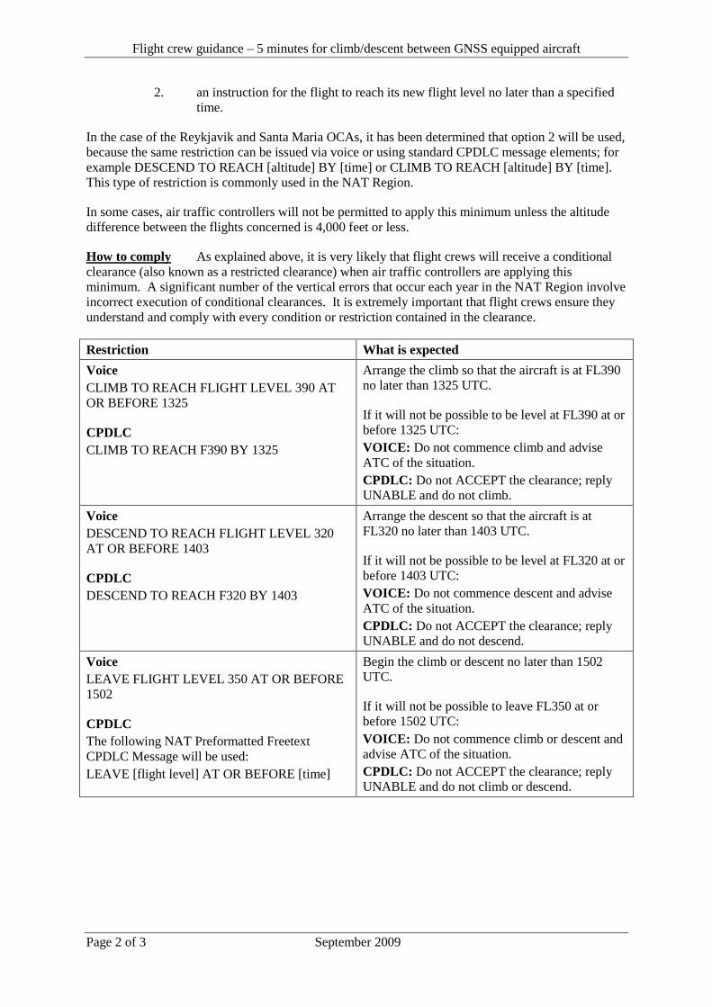
Flight crew guidance – 5 minutes for climb/descent between GNSS equipped aircraft
Page 2 of 3 September 2009
2. an instruction for the flight to reach its new flight level no later than a specified
time.
In the case of the Reykjavik and Santa Maria OCAs, it has been determined that option 2 will be used,
because the same restriction can be issued via voice or using standard CPDLC message elements; for
example DESCEND TO REACH [altitude] BY [time] or CLIMB TO REACH [altitude] BY [time].
This type of restriction is commonly used in the NAT Region.
In some cases, air traffic controllers will not be permitted to apply this minimum unless the altitude
difference between the flights concerned is 4,000 feet or less.
How to comply As explained above, it is very likely that flight crews will receive a conditional
clearance (also known as a restricted clearance) when air traffic controllers are applying this
minimum. A significant number of the vertical errors that occur each year in the NAT Region involve
incorrect execution of conditional clearances. It is extremely important that flight crews ensure they
understand and comply with every condition or restriction contained in the clearance.
Restriction What is expected
Voice
CLIMB TO REACH FLIGHT LEVEL 390 AT
OR BEFORE 1325
CPDLC
CLIMB TO REACH F390 BY 1325
Arrange the climb so that the aircraft is at FL390
no later than 1325 UTC.
If it will not be possible to be level at FL390 at or
before 1325 UTC:
VOICE: Do not commence climb and advise
ATC of the situation.
CPDLC: Do not ACCEPT the clearance; reply
UNABLE and do not climb.
Voice
DESCEND TO REACH FLIGHT LEVEL 320
AT OR BEFORE 1403
CPDLC
DESCEND TO REACH F320 BY 1403
Arrange the descent so that the aircraft is at
FL320 no later than 1403 UTC.
If it will not be possible to be level at FL320 at or
before 1403 UTC:
VOICE: Do not commence descent and advise
ATC of the situation.
CPDLC: Do not ACCEPT the clearance; reply
UNABLE and do not descend.
Voice
LEAVE FLIGHT LEVEL 350 AT OR BEFORE
1502
CPDLC
The following NAT Preformatted Freetext
CPDLC Message will be used:
LEAVE [flight level] AT OR BEFORE [time]
Begin the climb or descent no later than 1502
UTC.
If it will not be possible to leave FL350 at or
before 1502 UTC:
VOICE: Do not commence climb or descent and
advise ATC of the situation.
CPDLC: Do not ACCEPT the clearance; reply
UNABLE and do not climb or descend.
Flight crew guidance – 5 minutes for climb/descent between GNSS equipped aircraft
Page 3 of 3 September 2009
Possible issues There are some possible issues for flight crews that may arise from the application of
this minimum.
Traffic Alert and Collision Avoidance System (TCAS) – This minimum allows air traffic controllers
to temporarily reduce the longitudinal spacing significantly. This means that it is possible that flights
will detect other flights climbing or descending through their altitude, because the distance could
reduce to approximately 40NM. If there is any concern regarding the proximity of another aircraft,
flight crews must not hesitate to clarify the situation and take appropriate action to ensure safety of
flight.
Differences in application – Different ATC units will apply this minimum differently. This means
that it is not possible to provide every potential clearance or restriction that may be used. As well,
other operational circumstances may dictate that additional instructions be included with the
clearance, making it even less possible to explain every possible clearance or instruction that may be
issued. If there is any doubt about the intent of a clearance or a restriction, it is critical to contact
ATC, via voice or CPDLC, to confirm the intent.
Examples of clearances
VOICE CPDLC
REYKJAVIK OAC CLEARS AIRLINER 186,
CLIMB TO REACH FLIGHT LEVEL 340 AT
OR BEFORE 1715. REPORT REACHING
[UM26] CLIMB TO REACH F340 BY 1715
[UM129] REPORT LEVEL F340
AIRLINER 128, AMENDED LEVEL
CLEARANCE. SANTA MARIA CLEARS
AIRLINER 128 DESCEND TO REACH
FLIGHT LEVEL 360 AT OR BEFORE 1245.
REPORT REACHING.
[UM28] DESCEND TO REACH F360 BY 1245
[UM129] REPORT LEVEL F360
AIRLINER 47, AMENDED LEVEL
CLEARANCE. GANDER CLEARS AIRLINER
47, CLIMB TO AND MAINTAIN FLIGHT
LEVEL 380. REPORT REACHING. LEAVE
FLIGHT LEVEL 360 AT OR BEFORE 1828.
[UM20] CLIMB TO AND MAINTAIN F380
[UM129] REPORT LEVEL F380
[freetext] LEAVE F360 AT OR BEFORE 1828
- END -
Serial Number: 2010-006
Subject: ORCA Procedures for
Shanwick
Issued/Effective: 18 March 2004
The purpose of North Atlantic Operations Bulletin 2010-006 is to promulgate the Oceanic Clearance
Delivery via data link procedures on behalf of the Shanwick Oceanic Area Control Centre.
Any Queries relating to this document should be addressed to:
Head of Engineering Operations Support
ScOACC
Atlantic House.
Sherwood Road.
Prestwick.
Ayrshire. KA9 2NR.
United Kingdom
Tel: 00 44 (0)1292 692772
Fax: 00 44 (0)1292 692640
e-mail: [email protected]
NOTICE NAT Ops Bulletins are used to distribute information on behalf of the North Atlantic Systems Planning
Group (NAT SPG). The material contained therein may be developed within the working structure of the
NAT SPG or be third party documents posted at the request of a NAT SPG Member State. A printed or
electronic copy of this Bulletin, plus any associated documentation, is provided to the recipient as is and
without any warranties as to its description, condition, quality, fitness for purpose or functionality and for use
by the recipient solely for guidance only. The information published by ICAO in this document is made
available without warranty of any kind; the Organization accepts no responsibility or liability whether direct
or indirect, as to the currency, accuracy or quality of the information, nor for any consequence of its use. The
designations and the presentation of material in this publication do not imply the expression of any opinion
whatsoever on the part of ICAO concerning the legal status of any country, territory, city or area of its
authorities, or concerning the delimitation of its frontiers or boundaries.
The NAT OPS Bulletin Checklist, available at www.paris.icao.int (Documents, NAT Docs), contains an up to
date list of all current NAT Ops Bulletins.
There is no objection to the reproduction of extracts of information contained in this Bulletin if the source is
acknowledged.
Effective Date: 18th March 2004
Issue 11
Page 1 of 16
Delivery of Oceanic Clearances by ORCA - Shanwick
Guidance Material for Delivery of Oceanic Clearances by ORCA
(Shanwick)
Updated versions of this document are available on the NAT PCO website. (www.nat-pco.org)
Any Queries relating to this document should be addressed to: Head of Engineering Operations Support ScOACC Atlantic House. Sherwood Road. Prestwick. Ayrshire. KA9 2NR. United Kingdom Tel: 00 44 (0)1292 692772 Fax: 00 44 (0)1292 692640 e-mail: [email protected]
Effective Date: 18th March 2004
Issue 11
Page 2 of 16
Delivery of Oceanic Clearances by ORCA - Shanwick
Contents Contents …………… 2
Summary of Changes …………… 3
Glossary …………… 3
1. Introduction …………… 4
2. Connecting to ORCA …………… 5
3. Requesting Shanwick Oceanic Clearance …………… 6
4. Clearance Negotiation …………… 6
5. Clearance Delivery …………… 7
6. Clearance Acknowledgement …………… 8
7. Reclearances …………… 9
8. Time Revisions …………… 10
Appendix A - System Overview Diagram …………… 11
Appendix B - Terms Used in the RCL RMK/ Field …………… 12
Appendix C - ORCA Messages and Crew Actions …………… 13
Appendix D - Terms Used in ATC/ Field …………… 16
Effective Date: 18th March 2004
Issue 11
Page 3 of 16
Delivery of Oceanic Clearances by ORCA - Shanwick
Summary of Changes from Issue 10:
Reference: Revised uplink messages Appendix C Revised timers Section 3 Minor editorial changes Various
Glossary:
AEEC Airlines Electronic Engineering Committee
ACARS Aircraft Communications, Addressing and Reporting System
ARINC Aeronautical Radio Incorporated
CDO Clearance Delivery Officer
CLA Clearance Acknowledgement downlink message
CLX Oceanic Clearance uplink message
EGGX ICAO 4 letter code for Shanwick
ETA
Estimated Time of Arrival
FDPS Flight Data Processing System
FSM
Flight System Message
HF High Frequency
OACC Oceanic Area Control Centre
OCA Oceanic Control Area
ORCA
Oceanic Route Clearance Authorisation service
RCL Request for Clearance
ScOACC Scottish and Oceanic Area Control Centre
SITA TMI
Société Internationale de Télécommunications Aéronautiques Track Message Ident number
Effective Date: 18th March 2004
Issue 11
Page 4 of 16
Delivery of Oceanic Clearances by ORCA - Shanwick
VHF Very High Frequency
1. Introduction 1.1 The Prestwick Oceanic Area Control Centre (OACC) provides an air traffic control
service within the Shanwick Oceanic Control Area (OCA). All aircraft require permission in the form of an Oceanic Clearance prior to entering the Shanwick OCA.
1.2 Shanwick provides a Westbound Oceanic Clearance Delivery service via Datalink to
aircraft fitted with an appropriate specification of Aircraft Communications, Addressing and Reporting System (ACARS) equipment. This service is known as Oceanic Route Clearance Authorisation (ORCA).
1.3 ORCA is available via network service providers and utilises their respective air-ground
facilities. Appendix A provides an overview of this interface. 1.4 ORCA is configurable to accommodate variations in airline datalink communication
capabilities. The principle operations are: - datalink readback of clearance - voice readback of clearance
Datalink readback is the preferred mode of operation.
Effective Date: 18th March 2004
Issue 11
Page 5 of 16
Delivery of Oceanic Clearances by ORCA - Shanwick
2. Connecting to ORCA 2.1 The ORCA transaction is initiated in all cases by a downlink request (RCL). This may be
an AEEC 623 compliant RCL, or any suitable downlink reformatted by a ground based system into this format.
2.2 Any RCL must contain the following information, as a minimum:-
v Shanwick Entry Point. v ETA for Entry Point. v Requested Mach Number. v Requested Flight Level.
2.3 Crews should add remarks (RMK/) indicating the preferred alternative to the requested
clearance and maximum flight level that can be accepted at the Entry Point. Inclusion of this information greatly assists the Shanwick Controller and expedites clearance delivery process.
2.4 The RCL must contain the same callsign format as the current filed flight plan. 2.5 The RCL must comply with the formats shown in the examples below or it will be rejected
by ORCA. The RMK/ field is free text and should be used to provide additional information to the controller. Only those abbreviations specified in Appendix B are permitted. Examples:- -DOGAL/1255 M082F370-RMK/2ND NAT D F370 MAX F390 -DINIM/0750 M082F350-RMK/2ND F330 MAX F350 -ERAKA/1710 M082F350-RMK/2ND NAT A F350 MAX F370
(Due to FDPS specifications, the RCL should not exceed 80 characters in total.)
Effective Date: 18th March 2004
Issue 11
Page 6 of 16
Delivery of Oceanic Clearances by ORCA - Shanwick
3. Requesting Shanwick Oceanic Clearance 3.1 GENERAL 3.1.1 Aircraft must not enter Shanwick Oceanic Airspace without a clearance. 3.1.2 Crews should request Oceanic clearance not more than 90 minutes flying time from the OCA
boundary. RCLs outwith this parameter, will be rejected. 3.1.3 Crews should request Oceanic clearance not less than 30 minutes flying time from the OCA
boundary. RCLs outwith this parameter, will be rejected. 3.1.4 If a flight is within 15 minutes of the OCA boundary and no clearance has been received, the crew
must contact Shanwick by voice and advise the ATC authority for the airspace in which they are operating.
3.2 ORCA USE 3.2.1 Crews requesting via ORCA must contact Shanwick by voice if no clearance has been received
within 15 minutes of making a request for clearance. It is the responsibility of the crew to monitor this time period.
3.2.2 The crew should expect an advisory message from ORCA within 5 minutes. If this is not received
one further attempt to downlink an RCL can be made (provided the 30-minute parameter, above, can still be met). If this second attempt to downlink the RCL also fails to generate an advisory message the crew must revert to voice procedures.
Example, expected response to an RCL: RCL RECEIVED IF NO CLEARANCE WITHIN 15 MINUTES
CONTACT SHANWICK BY VOICE 3.2.3 ORCA RCLs do not require crews to state TMI. The CLX contains a Track identifier and includes
full route co-ordinates. 3.2.4 When the aircraft is estimated to be 10 minutes from the boundary, if the transaction has not
completed, ORCA will not be used to issue clearances. 4. Clearance Negotiation 4.1 Upon receipt of the RCL, the Shanwick controller may wish to negotiate the clearance requirements
with the crew. To achieve this, the controller may issue a datalink message instructing the crew to contact Shanwick by voice.
Example: RCL RECEIVED NEGOTIATION REQUIRED CONTACT SHANWICK BY VOICE
4.2 The crew must contact Shanwick by voice as soon as possible, using the phrase “<CALLSIGN>
ORCA CONTACT”. This phrase assists the communicator in identifying ORCA flights.
Effective Date: 18th March 2004
Issue 11
Page 7 of 16
Delivery of Oceanic Clearances by ORCA - Shanwick
4.3 The Oceanic Clearance will be issued via ORCA, unless otherwise advised by Shanwick. 5. Clearance Delivery 5.1 The ORCA clearance message (CLX) shall be uplinked to the aircraft and shall contain
the following information as a minimum:-
v Callsign v Shanwick Boundary Entry Point and ETA. v Flight Level. v Mach Number. v Route information i.e. full NAT Track or Random Route details. v Destination.
5.2 The crew must check that the callsign in the CLX matches the Flight Plan callsign. 5.3 Clearances issued for Random or NAT Track aircraft contain the full route co-ordinates.
Track aircraft clearances also include the Track identifier e.g. ALPHA, BRAVO etc. Crews must check that the route co-ordinates received match the published NAT track message and query any discrepancy using voice procedures.
5.4 The CLX may contain additional information, prefixed with the text “ATC/”. This may be
advisory information e.g. “LEVEL CHANGE or additional ATC instructions e.g. “NOT BEFORE 1125 AT GOMUP”. ATC/ messages are detailed in Appendix D.
5.5 If an aircraft is cleared via a different Entry Point from that requested, Shanwick will
calculate an ETA and this will be shown in the clearance. If this ETA differs from that calculated by the crew, by 3 minutes or more, Shanwick must be advised. (See section 8)
5.6 All Clearance messages terminate with the phrase- END OF MESSAGE. If this text is
not present, then data has been lost during transmission and the clearance must be ignored. Crews must revert to voice procedures.
5.7 If at any stage of an ORCA transaction the crew has cause for doubt, they must contact Shanwick by voice, using the phrase “<CALLSIGN> ORCA CONTACT”.
Effective Date: 18th March 2004
Issue 11
Page 8 of 16
Delivery of Oceanic Clearances by ORCA - Shanwick
6. Clearance Acknowledgement 6.1 On receipt of the CLX, crew actions shall depend upon the aircraft's downlink capabilities. 6.2 Datalink Acknowledgement
6.2.1 For those aircraft equipped to downlink a datalink acknowledgement (CLA) for the CLX,
the crew must send this message as soon as possible. 6.2.2 This CLX must be acknowledged. Should the crew require an alternative to the issued
clearance, they must request again. (See Section 7).
6.2.3 Upon receipt of a valid CLA message, ORCA will uplink a Clearance Confirmed message. The clearance transaction is not complete until the confirmation message is received. If the confirmation message is not received, the crew must contact Shanwick by voice. Example: CLA RECEIVED CLEARANCE CONFIRMED
6.2.4 If a CLA message is not received, Shanwick will issue a reminder message to the aircraft. Failure to acknowledge the cle arance will result in the clearance transaction being cancelled by ORCA and the crew being instructed to revert to voice procedures.
6.3 Voice Acknowledgement
6.3.1 For those aircraft who are NOT equipped to downlink a CLA, the crew must contact Shanwic k by voice, as soon as possible, using the phrase “<CALLSIGN> ORCA CLEARANCE RECEIVED, ADVISE READY FOR READBACK. This ORCA clearance is not valid until Shanwick has confirmed the read-back.

Effective Date: 18th March 2004
Issue 11
Page 9 of 16
Delivery of Oceanic Clearances by ORCA - Shanwick
7. Reclearances 7.1 If a crew requests a new clearance, or Shanwick requires a change to an existing
clearance, one or more CLXs may be received by the crew. These will be annotated “RECLEARANCE 1”, “RECLEARANCE 2” etc.
7.2 All reclearances must be acknowledged. If a reclearance is received before a previous
clearance, or reclearance, has been acknowledged, then the reclearance with the highest reclearance number should be acknowledged.
7.3 Due to Shanwick procedures, reclearances may not be numbered consecutively. This is not a cause for concern provided that the latest reclearance always has a higher number than any previous.
7.4 Having completed the transaction sequence, the crew may make a request for a change
to the clearance by ORCA or voice, and this request will be dealt with appropriate to the method of request.
7.5 A subsequent RCL does not cancel the issued clearance, which remains valid,
until the associated reclearance has been confirmed. 7.6 If Shanwick is unable to approve a request for a change to a clearance, the crew will
receive a reclearance which is a repeat of the original, but which contains the text;
ATC/ UNABLE TO APPROVE REQUEST
7.7 Such reclearances must be acknowledged. Failure to acknowledge the reclearance will result in the entire transaction being cancelled by ORCA.
Effective Date: 18th March 2004
Issue 11
Page 10 of 16
Delivery of Oceanic Clearances by ORCA - Shanwick
8. Time Revisions 8.1 If the ETA for the Entry Point changes by 3 minutes or more Shanwick must be advised.
This may be achieved by voice or by an ORCA request, containing the revised ETA. 8.2 The crew should expect to receive a Reclearance showing the revised ETA. This may be
a copy of the original CLX (containing the new ETA) or the CLX may contain a change in any clearance parameter, should the revised ETA make this necessary (accompanied by appropriate information in the ATC/ field).
8.3 If an aircraft is cleared via a different Entry Point from that requested, or previously
cleared, Shanwick will calculate a revised ETA for that Entry Point and this will be shown in the clearance. If this ETA is different from that calculated by the crew by 3 minutes or more, Shanwick must be advised.
8.4 All reclearances must be acknowledged.
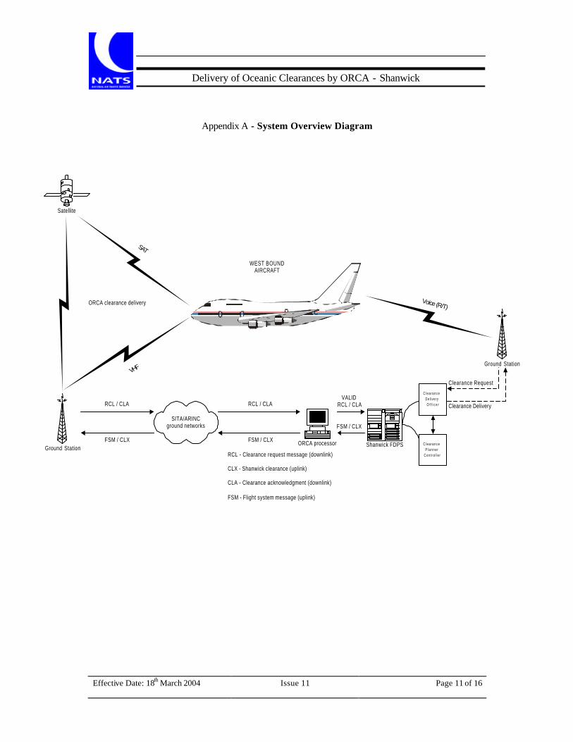
Effective Date: 18th March 2004
Issue 11
Page 11 of 16
Delivery of Oceanic Clearances by ORCA - Shanwick
Appendix A - System Overview Diagram
Ground Station
Satellite
SITA/ARINCground networks
Ground Station
Clearance Request
Clearance Delivery
Voice (R/T)
SAT
VHF
ORCA clearance delivery
WEST BOUNDAIRCRAFT
RCL / CLA RCL / CLAVALID
RCL / CLA
FSM / CLX FSM / CLX
RCL - Clearance request message (downlink)
CLX - Shanwick clearance (uplink)
CLA - Clearance acknowledgment (downlink)
FSM - Flight system message (uplink)
Shanwick FDPSORCA processor
FSM / CLX
C l e a r a n c e
D e l i v e r y
O f f i c e r
C l e a r a n c e
P l a n n e r
C o n t r o l l e r
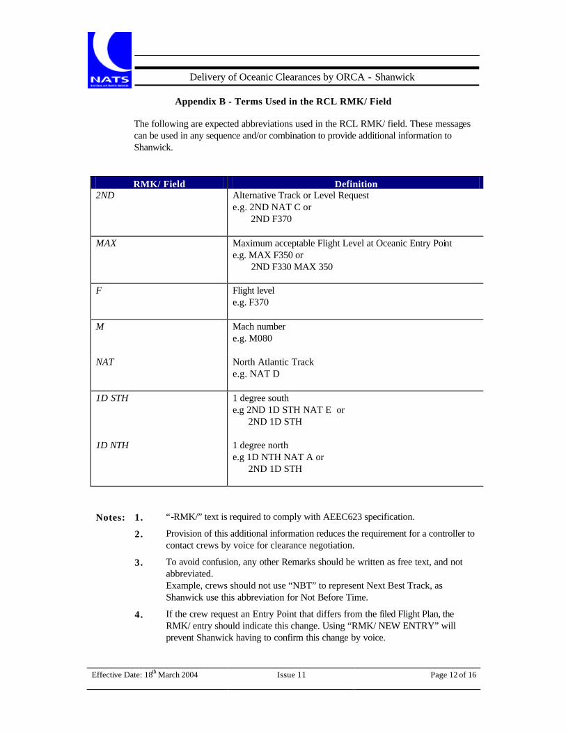
Effective Date: 18th March 2004
Issue 11
Page 12 of 16
Delivery of Oceanic Clearances by ORCA - Shanwick
Appendix B - Terms Used in the RCL RMK/ Field
The following are expected abbreviations used in the RCL RMK/ field. These messages can be used in any sequence and/or combination to provide additional information to Shanwick.
RMK/ Field Definition
2ND Alternative Track or Level Request e.g. 2ND NAT C or 2ND F370
MAX Maximum acceptable Flight Level at Oceanic Entry Point e.g. MAX F350 or 2ND F330 MAX 350
F
Flight level e.g. F370
M Mach number e.g. M080
NAT
North Atlantic Track e.g. NAT D
1D STH
1 degree south e.g 2ND 1D STH NAT E or 2ND 1D STH
1D NTH
1 degree north e.g 1D NTH NAT A or 2ND 1D STH
Notes: 1. “-RMK/” text is required to comply with AEEC623 specification.
2. Provision of this additional information reduces the requirement for a controller to contact crews by voice for clearance negotiation.
3. To avoid confusion, any other Remarks should be written as free text, and not abbreviated. Example, crews should not use “NBT” to represent Next Best Track, as Shanwick use this abbreviation for Not Before Time.
4. If the crew request an Entry Point that differs from the filed Flight Plan, the RMK/ entry should indicate this change. Using “RMK/ NEW ENTRY” will prevent Shanwick having to confirm this change by voice.
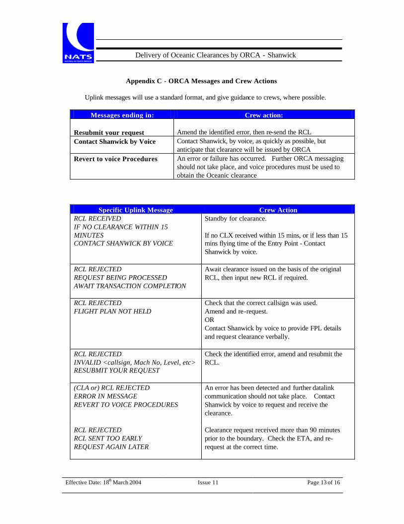
Effective Date: 18th March 2004
Issue 11
Page 13 of 16
Delivery of Oceanic Clearances by ORCA - Shanwick
Appendix C - ORCA Messages and Crew Actions
Uplink messages will use a standard format, and give guidance to crews, where possible.
Messages ending in: Crew action:
Resubmit your request Amend the identified error, then re-send the RCL Contact Shanwick by Voice Contact Shanwick, by voice, as quickly as possible, but
anticipate that clearance will be issued by ORCA Revert to voice Procedures An error or failure has occurred. Further ORCA messaging
should not take place, and voice procedures must be used to obtain the Oceanic clearance
Specific Uplink Message Crew Action
RCL RECEIVED IF NO CLEARANCE WITHIN 15 MINUTES CONTACT SHANWICK BY VOICE
Standby for clearance. If no CLX received within 15 mins, or if less than 15 mins flying time of the Entry Point - Contact Shanwick by voice.
RCL REJECTED REQUEST BEING PROCESSED AWAIT TRANSACTION COMPLETION
Await clearance issued on the basis of the original RCL, then input new RCL if required.
RCL REJECTED FLIGHT PLAN NOT HELD
Check that the correct callsign was used. Amend and re-request. OR Contact Shanwick by voice to provide FPL details and request clearance verbally.
RCL REJECTED INVALID <callsign, Mach No, Level, etc> RESUBMIT YOUR REQUEST
Check the identified error, amend and resubmit the RCL.
(CLA or) RCL REJECTED ERROR IN MESSAGE REVERT TO VOICE PROCEDURES
An error has been detected and further datalink communication should not take place. Contact Shanwick by voice to request and receive the clearance.
RCL REJECTED RCL SENT TOO EARLY REQUEST AGAIN LATER
Clearance request received more than 90 minutes prior to the boundary. Check the ETA, and re-request at the correct time.
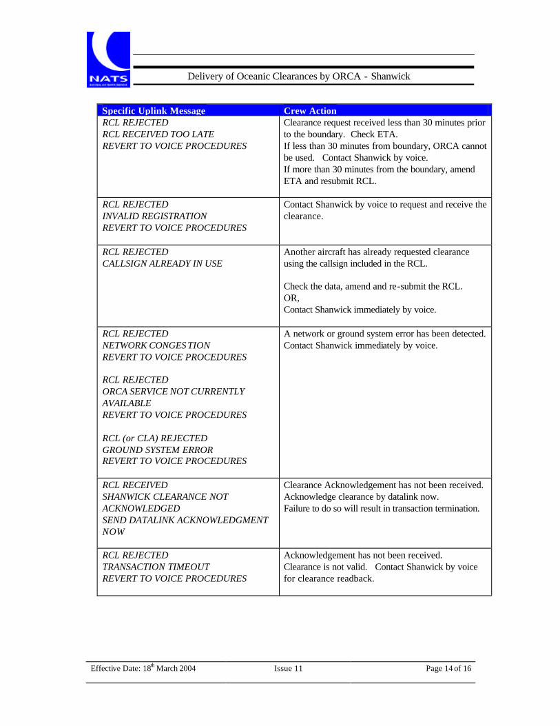
Effective Date: 18th March 2004
Issue 11
Page 14 of 16
Delivery of Oceanic Clearances by ORCA - Shanwick
Specific Uplink Message Crew Action RCL REJECTED RCL RECEIVED TOO LATE REVERT TO VOICE PROCEDURES
Clearance request received less than 30 minutes prior to the boundary. Check ETA. If less than 30 minutes from boundary, ORCA cannot be used. Contact Shanwick by voice. If more than 30 minutes from the boundary, amend ETA and resubmit RCL.
RCL REJECTED INVALID REGISTRATION REVERT TO VOICE PROCEDURES
Contact Shanwick by voice to request and receive the clearance.
RCL REJECTED CALLSIGN ALREADY IN USE
Another aircraft has already requested clearance using the callsign included in the RCL. Check the data, amend and re-submit the RCL. OR, Contact Shanwick immediately by voice.
RCL REJECTED NETWORK CONGES TION REVERT TO VOICE PROCEDURES RCL REJECTED ORCA SERVICE NOT CURRENTLY AVAILABLE REVERT TO VOICE PROCEDURES RCL (or CLA) REJECTED GROUND SYSTEM ERROR REVERT TO VOICE PROCEDURES
A network or ground system error has been detected. Contact Shanwick immediately by voice.
RCL RECEIVED SHANWICK CLEARANCE NOT ACKNOWLEDGED SEND DATALINK ACKNOWLEDGMENT NOW
Clearance Acknowledgement has not been received. Acknowledge clearance by datalink now. Failure to do so will result in transaction termination.
RCL REJECTED TRANSACTION TIMEOUT REVERT TO VOICE PROCEDURES
Acknowledgement has not been received. Clearance is not valid. Contact Shanwick by voice for clearance readback.
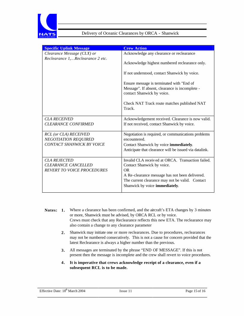
Effective Date: 18th March 2004
Issue 11
Page 15 of 16
Delivery of Oceanic Clearances by ORCA - Shanwick
Specific Uplink Message Crew Action Clearance Message (CLX) or Reclearance 1,…Reclearance 2 etc.
Acknowledge any clearance or reclearance Acknowledge highest numbered reclearance only. If not understood, contact Shanwick by voice. Ensure message is terminated with "End of Message". If absent, clearance is incomplete - contact Shanwick by voice. Check NAT Track route matches published NAT Track.
CLA RECEIVED CLEARANCE CONFIRMED
Acknowledgement received. Clearance is now valid. If not received, contact Shanwick by voice.
RCL (or CLA) RECEIVED NEGOTIATION REQUIRED CONTACT SHANWICK BY VOICE
Negotiation is required, or communications problems encountered. Contact Shanwick by voice immediately. Anticipate that clearance will be issued via datalink.
CLA REJECTED CLEARANCE CANCELLED REVERT TO VOICE PROCEDURES
Invalid CLA received at ORCA. Transaction failed. Contact Shanwick by voice. OR A Re-clearance message has not been delivered. The current clearance may not be valid. Contact Shanwick by voice immediately.
Notes: 1. Where a clearance has been confirmed, and the aircraft’s ETA changes by 3 minutes
or more, Shanwick must be advised, by ORCA RCL or by voice. Crews must check that any Reclearance reflects this new ETA. The reclearance may also contain a change to any clearance parameter
2. Shanwick may initiate one or more reclearances. Due to procedures, reclearances may not be numbered consecutively. This is not a cause for concern provided that the latest Reclearance is always a higher number than the previous.
3. All messages are terminated by the phrase “END OF MESSAGE”. If this is not present then the message is incomplete and the crew shall revert to voice procedures.
4. It is imperative that crews acknowledge receipt of a clearance, even if a subsequent RCL is to be made.

Effective Date: 18th March 2004
Issue 11
Page 16 of 16
Delivery of Oceanic Clearances by ORCA - Shanwick
Appendix D - Terms Used in the ATC/ Field
For Information
Level Change Clearance is at a level different from that requested or previously cleared.
Mach Change Clearance is at a speed different from that requested or previously cleared.
Entry Point Change Clearance is via an Entry Point different from that requested, or previously cleared.
Route Change At {Position} Clearance is via a single route point different from that requested or previously cleared.
Route Change At Multiple Route Points Clearance is via a route that has two or more points different from that requested or previously cleared.
Request Level Change At {Position} Pilot should request a level change at point specified.
Unable To Approve Request Shanwick unable to approve request for change to clearance. This Reclearance should be a copy of the previous clearance. Crews should check for any discrepancy or ATC/ field information.
Further Instructions
Not Before {Time} At {Position} Cross specified position not before the specified time.
Not Later Than {Time} At {Position} Cross specified position not later than the specified time.
Leave Level {Level} At {Position} Leave the specified level at or after passing the specified position.
Leave Level {Level} At {Time} Leave the specified level at or after the specified time.
Be Level {Level} At {Position} Reach the specified level at or before the specified position.
Be Level {Level} At {Time} Reach the specified level at or before the specified time.
Clearance Limit {Position} Although further routing is indicated on clearance, clearance is only valid to specified point and onward clearance must be confirmed beyond this point.
Note: The ATC/ field is not always present. If present it may contain none, one, or more of
the terms above.