Embed Size (px)
Citation preview

NASA’sNearRealTimeDataUsageandPlan
RamaNemani,TsengdarLeePresentedatCCSP/IMAPPUsers’GroupMeeting
June26,2017
FalseColorABIImage(2017-04-01,16:30UTM)RayleighscatteringeffectsareremovedusingtheEOS6Sradiativetransfercode.R:1.61µmG:0.865µmB:0.64µm

NASA’sSupportsinNearRealTimeActivities- PastandFuture
• NASAhasinvestedinIPOPP,LANCE,CSPPandIMAPPinthepastmanyyears.
• NASAusesNRTdatatosupportweatherresearchandtransitionresearchproductstoforecastoperations.
• NASA’sDisasterPrograminAppliedScienceusesNRTdataheavily.• NASAcurrentlydoesnothaveaplantobuildDirectBroadcastsystemsin
futuresatellitemissionswhiletheplannedNOAAGOESandPOESsystemswillbeabletoprovidemanyEOSeradevelopedproducts.
• Therefore,anewstrategicdirectionfortheNRTactivitiesisneededtoguidefutureinvestments.

3
InputbyStevePlatnick andtheGoddardTeam

NASAGOES-RFocusAreasWeather
•Newmeasurementcapabilities(ABI,GLM)•Hurricanes,severelocalstorms,MCS,atmos.rivers,ETcyclones:– Roleofaerosolsonstormmorph-ology:cloudtopmicrophysicalevolution,lightning,diurnalcycle– Diurnalvariabilityofcloud-toppropertiesandlightning
•StrongsynergywithGPM,CYGNSS,TROPICS,fieldcampaigns
AtmosphericComposition•ProvideshightemporalresolutionofVIIRS-likecloud/aerosolsproperties,volcanicash•LightningdatavaluableforNOx•Informationonlocalvariabilityandtransport•Potentialalgorithmimprovements•StrongsynergywithMODIS,VIIRS,TEMPO,ACE
MODISCloudsandAOD

NASAGOES-RFocusAreasCloudsandRadiation
•ProvideshightemporalresolutionofVIIRS-likecloudproperties•Diurnalevolutionofcloud-toppropertiesforavarietyofcloudtypes/systems•DevelopmentofconsistentcloudclimatedatarecordsfromglobalconstellationofGEOimagers•StrongsynergywithMODIS,VIIRS,ACE,DSCOVR
Terrestrial/Oceans•Provideshightemporalresolutionforlandsurfaceproperties:vegetation,surfacetemperature,fires,snow/ice,floods/standingwater– Cropseasonalproductionmodels– Evapotranspiration/watercycle
•Exploringoceancolorbenefits– Improvedatmos.correction
•StrongsynergywithMODIS,VIIRS,SMAP,GeoCAPE
Vegetationindex
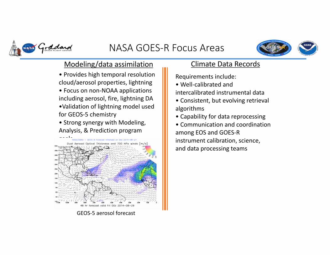
NASAGOES-RFocusAreasModeling/dataassimilation
•Provideshightemporalresolutioncloud/aerosolproperties,lightning•Focusonnon-NOAAapplicationsincludingaerosol,fire,lightningDA•ValidationoflightningmodelusedforGEOS-5chemistry•StrongsynergywithModeling,Analysis,&Predictionprogramgoals
GEOS-5aerosolforecast
ClimateDataRecordsRequirementsinclude:•Well-calibratedandintercalibrated instrumentaldata•Consistent,butevolvingretrievalalgorithms•Capabilityfordatareprocessing•CommunicationandcoordinationamongEOSandGOES-Rinstrumentcalibration,science,anddataprocessingteams

7
•NASAshouldmakestrategicinvestmentsineitheraGOES-RscienceteamorGOES-RelementswithinotherNASAscienceteamstoconductthediverseresearchdescribedinthewhitepaper.
•ToproduceconsistentGEOandLEOdatarecords:1) Developaconsistentsetof2andL3sciencealgorithms foruseacrossGEOandLEOinstrumentrecordsthatarecriticalforestablishingcontinuityofClimate&EarthScienceDataRecords(CESDRs);
2)establishanintegratedinstrumentandL1calibrationteamtoconductsystematicevaluationsofGEOimagerperformanceandberesponsibleforL1Bcodethatallowsforreprocessingandforward-processingalgorithmtestingindataformatsconsistentwithESDISandlegacyalgorithms;
3)expandtheroleoftheLEOScienceInvestigator-ledProcessingSystem(SIPS)toinclude(re)processing,archiving,anddistributionofNASA-fundedGEOimagerscienceteamdataproducts;and
4)establishindependentdiscipline-specificNASAValidationTeamstoassesstheNASA-fundedABI(andotherGEOimagers)CESDRsandworkcloselywiththealgorithmteamstoensurethatvalidationfindingsinformalgorithmrefinement.
Recommendations

NASA EARTH EXCHANGE (NEX).
+ NEX is virtual collaborative that brings scientists together in a knowledge-based social network and provides the necessary tools, computing power, and access to bigdata to accelerate research, innovation and provide transparency.
OVERVIEW
To provide “science as a service” to the Earth science community addressing global
environmental challenges
VISION
To improve efficiency and expand the scope of NASA Earth science technology, research and
applications programs
GOAL

NEX Provides a Complete Work Environment “Science As A Service”
COLLABORATION
Over400Members
CENTRALIZEDDATAREPOSITORY
Over2.3PBofData
COMPUTING
ScalableDiverseSecure/Reliable
KNOWLEDGE
WorkflowsMachineImagesModelcodesRe-useablesoftware

NEX Resources
Portal• Web server• Database server• 503 registered members
(up from 420) Sandbox
• 96-core server, 264GB memory, with 320 TB storage
• 48-core server, 128 GB, 163 TB storage
HPC• 720-core dedicated queue
+ access to rest of Pleiades
• 181 users/44 active (153/40 last year)
• 2.3 PB storage (from 850TB)
Models/Tools/Workflows used by NEX User Community
• GEOS-5• CESM• WRF• RegCM• VIC• BGC• LPJ• TOPS• BEAMS• Fmask• LEDAPS• METRIC…
Data (>2 PB on & near-line)
• Landsat• MODIS• TRMM• GRACE• ICESAT• CMIP5• NCEP• MERRA• NARR• PRISM• DAYMET• NAIP• Digital Globe• NEX-DCP30• NEX-GDDP• WELD• NAFD-NEX

Science at NEX
Global Vegetation Biomass at 100m resolutionby blending data from 4 different satellites
High resolution climate projections for climate impact studies
High resolution monthly global data for monitoring forests, crops and water resources
Mapping fallowed area in California during drought
Machine learning and Data mining – moving towards more data-driven approaches

OpenNEX –A private public partnership
NASAPrivateCloud CommercialPublicCloud
• Restrictedaccess• NASAfunded• Focusonlarge-scalemodelingandanalysis• Idealforproducingresearch
quality/reproducibleresults
• BuildsonNEX• Openaccess• User-funded• Idealforprototyping,exploration and
communityengagement

GOES-NEX Processing Plan

Product SpatialResolution
Frequency
Incident solarradiation,w/m2
1km 15minutes
PhotovoltaicEnergy,kw/PV 1km 15minutes
PhotovoltaicEnergyForecast– 30minutes,kw/PV
1km 30minutes
GOES-NEX Near Real-time Products
GOES-16fromMSFCGRBReceptiondishProductgenerationatARC/NEXProductdistributiononAWS,7dayrotationAlgorithmsfromJAXA/ChibaUniversity
IncidentSolarRadiationoverJapanderivedfromHimawari

SSR Generation Product Evaluation
VegetationProduct Suite
VI (NDVI, EVI)
LAI/ FPAR
GPP/ NPP
Community, General consumer
Applications
DAAC NOAA CLASS
MODIS
GOES-16
NEX SCIENCE CODE DEVELOPMENT
Indirect Validation
Direct Validation
Uncertainty Assessment
GriddingGridding
Geometric Correction
MAIAC
Phenology
PRODUCTS EC2
Containers
S3
NEX PRODUCTION SYSTEM
QA
Community,
ValidationDevelopement
Compute
SchedulersContainers
WBS 2.0
WBS 3.0
WBS 4.0
WBS 5.0
Solar Radiation
Planned GOES-NEX Land Products Processing

Product Algorithm Current use Frequency (all at 1km)
Remarks related to NOAA products
Surface Reflectances
MAIAC (Lyapustin et al., 2011)
MODIS/VIIRS daily NOAA has no plans
Solar Radiation HIMAWARI (Takaneka et al., 2011)
AHI/HIMAWARI daily NOAA plans for 25km/50 km products
Vegetation Index (EVI/NDVI)
MOD13Q1 (Huete et al., 2002)
MODIS/VIIRS daily/weekly NOAA plans use top of atmosphere (TOA) data only
LAI/FPAR MOD15A2 (Myneni et al., 2002)
MODIS/VIIRS daily/weekly NOAA has no plans
GPP/NPP MOD17A2 (Running et al., 1999)
MODIS hourly/daily/annual NOAA has no plans
Phenology MOD12Q2 (Ganguly et al., 2010)
MODIS/VIIRS annual NOAA has no plans
QA/QC* All products MODIS/VIIRS daily/annual
Planned GOES-NEX Land Products

Planned GOES-NEX Land Products

Advantages of GOES-NEX over MODIS, 38% more cloud-free data

Advantages of GOES-NEX over MODIS, 22% more cloud-free data

Multi-Angle Implementation of Atmospheric Correction (MAIAC)
Operational Implementation
Primary Outputs:Surface Reflectances
Secondary Outputs:
Snow CoverCloud CoverAerosol Optical DepthAlbedo