Embed Size (px)
Citation preview
Cronología de Lanzamientos Espaciales
Año 1988 Recopilación de datos Ing. Eladio Miranda Batlle. Los textos, imágenes y tablas fueron obtenidos de la National Space Science. Data Center. NASA
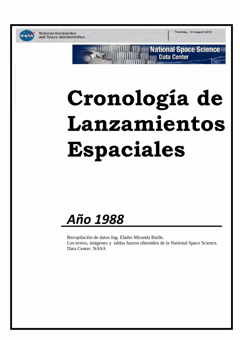
NASA - NSSDC - Spacecraft - Query Results
http://nssdc.gsfc.nasa.gov/nmc/spacecraftSearch.do;jsessionid=DBD87A117563263CD16D5F737C30DDF2[04/02/2011 23:37:41]
Saturday, 05 February 2011
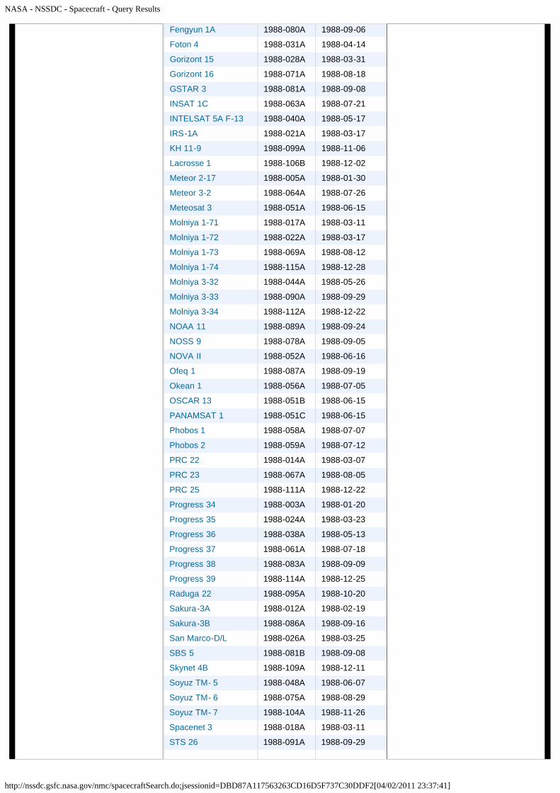
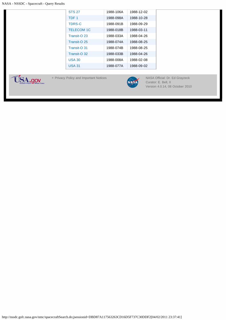
Spacecraft Query Results
There were 144 spacecraft returned.
Spacecraft Name NSSDC ID Launch Date
Astra 1A 1988-109B 1988-12-11
Buran 1988-100A 1988-11-15
Cosmos 1908 1988-001A 1988-01-06
Cosmos 1909 1988-002A 1988-01-15
Cosmos 1910 1988-002B 1988-01-15
Cosmos 1911 1988-002C 1988-01-15
Cosmos 1912 1988-002D 1988-01-15
Cosmos 1913 1988-002E 1988-01-15
Cosmos 1914 1988-002F 1988-01-15
Cosmos 1915 1988-004A 1988-01-26
Cosmos 1916 1988-007A 1988-02-03
Cosmos 1917 1988-009A 1988-02-18
Cosmos 1918 1988-009B 1988-02-18
Cosmos 1919 1988-009C 1988-02-18
Cosmos 1920 1988-010A 1988-02-18
Cosmos 1921 1988-011A 1988-02-19
Cosmos 1922 1988-013A 1988-02-26
Cosmos 1923 1988-015A 1988-03-10
Cosmos 1924 1988-016A 1988-03-11
Cosmos 1925 1988-016B 1988-03-11
Cosmos 1926 1988-016C 1988-03-11
Cosmos 1927 1988-016D 1988-03-11
Cosmos 1928 1988-016E 1988-03-11
Cosmos 1929 1988-016F 1988-03-11
Cosmos 1930 1988-016G 1988-03-11
Cosmos 1931 1988-016H 1988-03-11
Cosmos 1932 1988-019A 1988-03-14
Cosmos 1933 1988-020A 1988-03-15
Cosmos 1934 1988-023A 1988-03-22
Cosmos 1935 1988-025A 1988-03-24
Cosmos 1936 1988-027A 1988-03-30
Cosmos 1937 1988-029A 1988-04-05
Cosmos 1938 1988-030A 1988-04-11
Cosmos 1939 1988-032A 1988-04-20
Cosmos 1940 1988-034A 1988-04-26
Cosmos 1941 1988-035A 1988-04-27
NSSDC MasterCatalog Search
Spacecraft
Experiments
Data Collections
Personnel
Publications
Maps
New/Updated Data
Lunar/Planetary Events
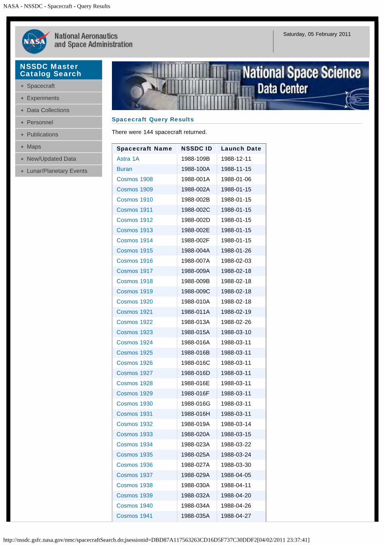
NASA - NSSDC - Spacecraft - Query Results
http://nssdc.gsfc.nasa.gov/nmc/spacecraftSearch.do;jsessionid=DBD87A117563263CD16D5F737C30DDF2[04/02/2011 23:37:41]
Cosmos 1942 1988-037A 1988-05-12
Cosmos 1943 1988-039A 1988-05-15
Cosmos 1944 1988-041A 1988-05-18
Cosmos 1945 1988-042A 1988-05-19
Cosmos 1946 1988-043A 1988-05-21
Cosmos 1947 1988-043B 1988-05-21
Cosmos 1948 1988-043C 1988-05-21
Cosmos 1949 1988-045A 1988-05-28
Cosmos 1950 1988-046A 1988-05-30
Cosmos 1951 1988-047A 1988-05-31
Cosmos 1952 1988-049A 1988-06-11
Cosmos 1953 1988-050A 1988-06-14
Cosmos 1954 1988-053A 1988-06-21
Cosmos 1955 1988-054A 1988-06-22
Cosmos 1956 1988-055A 1988-06-23
Cosmos 1957 1988-057A 1988-07-07
Cosmos 1958 1988-060A 1988-07-14
Cosmos 1959 1988-062A 1988-07-18
Cosmos 1960 1988-065A 1988-07-28
Cosmos 1961 1988-066A 1988-08-01
Cosmos 1962 1988-068A 1988-08-08
Cosmos 1963 1988-070A 1988-08-16
Cosmos 1964 1988-072A 1988-08-23
Cosmos 1965 1988-073A 1988-08-23
Cosmos 1966 1988-076A 1988-08-30
Cosmos 1967 1988-079A 1988-09-06
Cosmos 1968 1988-082A 1988-09-09
Cosmos 1969 1988-084A 1988-09-15
Cosmos 1970 1988-085A 1988-09-16
Cosmos 1971 1988-085B 1988-09-16
Cosmos 1972 1988-085C 1988-09-16
Cosmos 1973 1988-088A 1988-09-22
Cosmos 1974 1988-092A 1988-10-03
Cosmos 1975 1988-093A 1988-10-11
Cosmos 1976 1988-094A 1988-10-13
Cosmos 1977 1988-096A 1988-10-25
Cosmos 1978 1988-097A 1988-10-27
Cosmos 1979 1988-101A 1988-11-18
Cosmos 1980 1988-102A 1988-11-23
Cosmos 1981 1988-103A 1988-11-24
Cosmos 1982 1988-105A 1988-11-30
Cosmos 1983 1988-107A 1988-12-08
Cosmos 1984 1988-110A 1988-12-16
Cosmos 1985 1988-113A 1988-12-23
Cosmos 1986 1988-116A 1988-12-29
DMSP 5D-2/F09 1988-006A 1988-02-03
Ekran 18 1988-036A 1988-05-06
Ekran 19 1988-108A 1988-12-10
EUTELSAT 5 1988-063B 1988-07-21
NASA - NSSDC - Spacecraft - Query Results
http://nssdc.gsfc.nasa.gov/nmc/spacecraftSearch.do;jsessionid=DBD87A117563263CD16D5F737C30DDF2[04/02/2011 23:37:41]
Fengyun 1A 1988-080A 1988-09-06
Foton 4 1988-031A 1988-04-14
Gorizont 15 1988-028A 1988-03-31
Gorizont 16 1988-071A 1988-08-18
GSTAR 3 1988-081A 1988-09-08
INSAT 1C 1988-063A 1988-07-21
INTELSAT 5A F-13 1988-040A 1988-05-17
IRS-1A 1988-021A 1988-03-17
KH 11-9 1988-099A 1988-11-06
Lacrosse 1 1988-106B 1988-12-02
Meteor 2-17 1988-005A 1988-01-30
Meteor 3-2 1988-064A 1988-07-26
Meteosat 3 1988-051A 1988-06-15
Molniya 1-71 1988-017A 1988-03-11
Molniya 1-72 1988-022A 1988-03-17
Molniya 1-73 1988-069A 1988-08-12
Molniya 1-74 1988-115A 1988-12-28
Molniya 3-32 1988-044A 1988-05-26
Molniya 3-33 1988-090A 1988-09-29
Molniya 3-34 1988-112A 1988-12-22
NOAA 11 1988-089A 1988-09-24
NOSS 9 1988-078A 1988-09-05
NOVA II 1988-052A 1988-06-16
Ofeq 1 1988-087A 1988-09-19
Okean 1 1988-056A 1988-07-05
OSCAR 13 1988-051B 1988-06-15
PANAMSAT 1 1988-051C 1988-06-15
Phobos 1 1988-058A 1988-07-07
Phobos 2 1988-059A 1988-07-12
PRC 22 1988-014A 1988-03-07
PRC 23 1988-067A 1988-08-05
PRC 25 1988-111A 1988-12-22
Progress 34 1988-003A 1988-01-20
Progress 35 1988-024A 1988-03-23
Progress 36 1988-038A 1988-05-13
Progress 37 1988-061A 1988-07-18
Progress 38 1988-083A 1988-09-09
Progress 39 1988-114A 1988-12-25
Raduga 22 1988-095A 1988-10-20
Sakura-3A 1988-012A 1988-02-19
Sakura-3B 1988-086A 1988-09-16
San Marco-D/L 1988-026A 1988-03-25
SBS 5 1988-081B 1988-09-08
Skynet 4B 1988-109A 1988-12-11
Soyuz TM- 5 1988-048A 1988-06-07
Soyuz TM- 6 1988-075A 1988-08-29
Soyuz TM- 7 1988-104A 1988-11-26
Spacenet 3 1988-018A 1988-03-11
STS 26 1988-091A 1988-09-29
NASA - NSSDC - Spacecraft - Query Results
http://nssdc.gsfc.nasa.gov/nmc/spacecraftSearch.do;jsessionid=DBD87A117563263CD16D5F737C30DDF2[04/02/2011 23:37:41]
STS 27 1988-106A 1988-12-02
TDF 1 1988-098A 1988-10-28
TDRS-C 1988-091B 1988-09-29
TELECOM 1C 1988-018B 1988-03-11
Transit-O 23 1988-033A 1988-04-26
Transit-O 25 1988-074A 1988-08-25
Transit-O 31 1988-074B 1988-08-25
Transit-O 32 1988-033B 1988-04-26
USA 30 1988-008A 1988-02-08
USA 31 1988-077A 1988-09-02
+ Privacy Policy and Important Notices NASA Official: Dr. Ed GrayzeckCurator: E. Bell, IIVersion 4.0.14, 08 October 2010
NASA - NSSDC - Spacecraft - Details
http://nssdc.gsfc.nasa.gov/nmc/spacecraftDisplay.do?id=1988-109B[05/02/2011 0:01:06]
Saturday, 05 February 2011
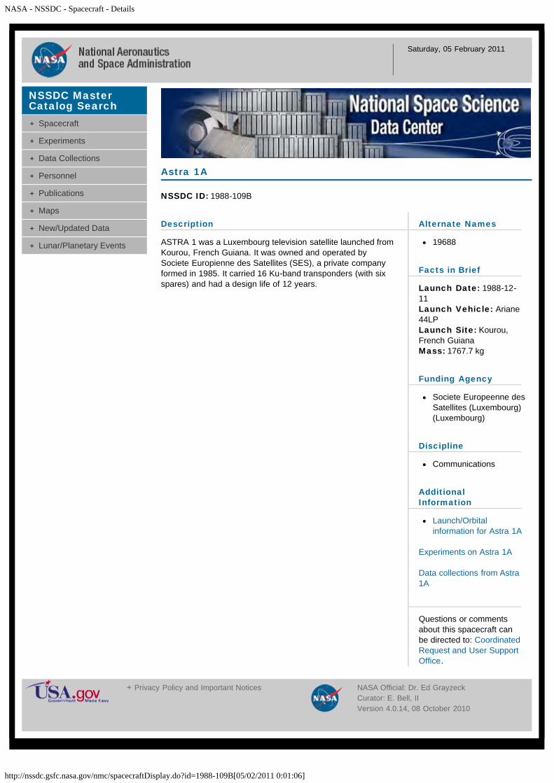
Description
ASTRA 1 was a Luxembourg television satellite launched fromKourou, French Guiana. It was owned and operated bySociete Europienne des Satellites (SES), a private companyformed in 1985. It carried 16 Ku-band transponders (with sixspares) and had a design life of 12 years.
Astra 1A
NSSDC ID: 1988-109B
Alternate Names
19688
Facts in Brief
Launch Date: 1988-12-11Launch Vehicle: Ariane44LPLaunch Site: Kourou,French GuianaMass: 1767.7 kg
Funding Agency
Societe Europeenne desSatellites (Luxembourg)(Luxembourg)
Discipline
Communications
AdditionalInformation
Launch/Orbitalinformation for Astra 1A
Experiments on Astra 1A
Data collections from Astra1A
Questions or commentsabout this spacecraft canbe directed to: CoordinatedRequest and User SupportOffice.
NSSDC MasterCatalog Search
Spacecraft
Experiments
Data Collections
Personnel
Publications
Maps
New/Updated Data
Lunar/Planetary Events
+ Privacy Policy and Important Notices NASA Official: Dr. Ed GrayzeckCurator: E. Bell, IIVersion 4.0.14, 08 October 2010
NASA - NSSDC - Spacecraft - Details
http://nssdc.gsfc.nasa.gov/nmc/spacecraftDisplay.do?id=1988-100A[05/02/2011 0:01:32]
Saturday, 05 February 2011
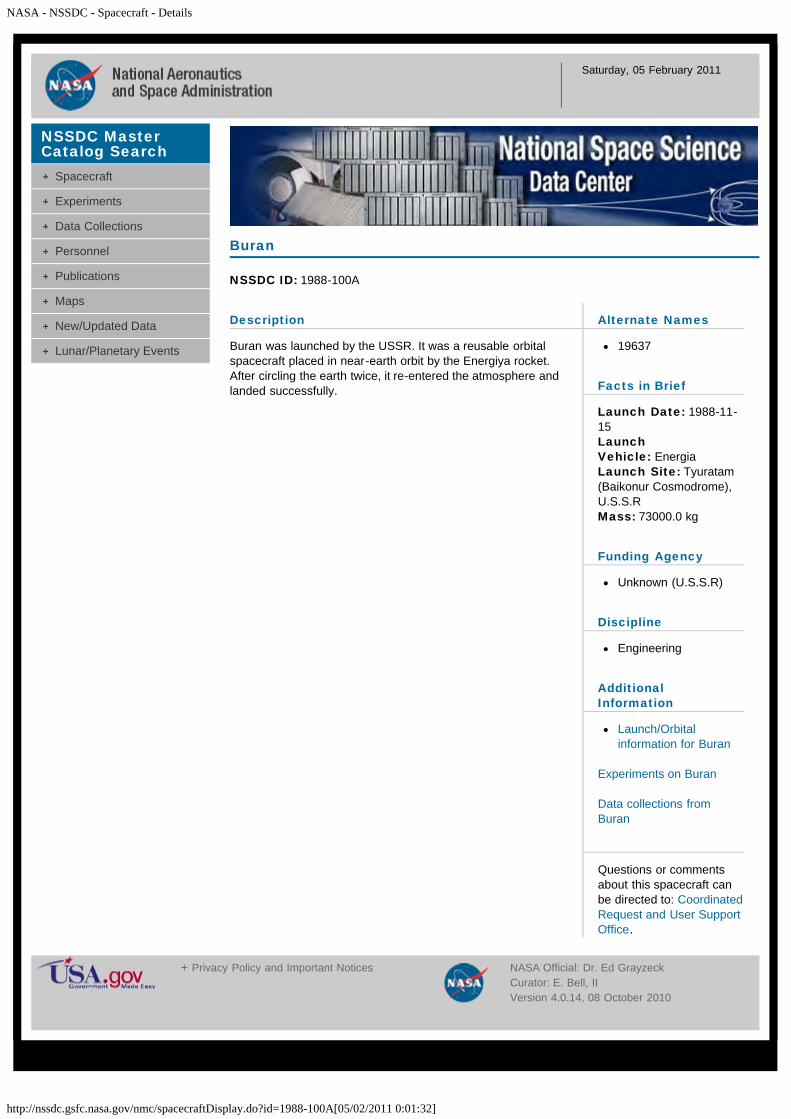
Description
Buran was launched by the USSR. It was a reusable orbitalspacecraft placed in near-earth orbit by the Energiya rocket.After circling the earth twice, it re-entered the atmosphere andlanded successfully.
Buran
NSSDC ID: 1988-100A
Alternate Names
19637
Facts in Brief
Launch Date: 1988-11-15LaunchVehicle: EnergiaLaunch Site: Tyuratam(Baikonur Cosmodrome),U.S.S.RMass: 73000.0 kg
Funding Agency
Unknown (U.S.S.R)
Discipline
Engineering
AdditionalInformation
Launch/Orbitalinformation for Buran
Experiments on Buran
Data collections fromBuran
Questions or commentsabout this spacecraft canbe directed to: CoordinatedRequest and User SupportOffice.
NSSDC MasterCatalog Search
Spacecraft
Experiments
Data Collections
Personnel
Publications
Maps
New/Updated Data
Lunar/Planetary Events
+ Privacy Policy and Important Notices NASA Official: Dr. Ed GrayzeckCurator: E. Bell, IIVersion 4.0.14, 08 October 2010
NASA - NSSDC - Spacecraft - Details
http://nssdc.gsfc.nasa.gov/nmc/spacecraftDisplay.do?id=1988-001A[05/02/2011 0:01:53]
Saturday, 05 February 2011
Description
Cosmos 1908 was a Soviet ELINT (Electronic and SignalsIntelligence) satellite launched from the Plesetsk cosmodrome.
From 1965 to 1967 two dedicated ELINT systems were tested:the Tselina and the Navy's US. Both reached service, since theMinistry of Defence could not force a single system on themilitary services.
Tselina was developed by Yuzhnoye and consisted of twosatellites: Tselina-O for general observations and Tselina-D fordetailed observations. ELINT systems for Tselina were firsttested under the Cosmos designation in 1962 to 1965. The firstTselina-O was launched in 1970. The Tselina-D took a longtime to enter service due to delays in payload developmentand weight growth. The whole Tselina system was notoperational until 1976. Constant improvement resulted inTselina-O being abandoned in 1984 and all systems being puton Tselina-D.
Cosmos 1908
NSSDC ID: 1988-001A
Alternate Names
18748
Facts in Brief
Launch Date: 1988-01-06LaunchVehicle: Tsiklon-3Launch Site: Plesetsk,U.S.S.RMass: 1600.0 kg
Funding Agency
Unknown (U.S.S.R)
Discipline
Surveillance and OtherMilitary
AdditionalInformation
Launch/Orbitalinformation for Cosmos1908
Experiments on Cosmos1908
Data collections fromCosmos 1908
Questions or commentsabout this spacecraft canbe directed to: CoordinatedRequest and User SupportOffice.
NSSDC MasterCatalog Search
Spacecraft
Experiments
Data Collections
Personnel
Publications
Maps
New/Updated Data
Lunar/Planetary Events
+ Privacy Policy and Important Notices NASA Official: Dr. Ed GrayzeckCurator: E. Bell, IIVersion 4.0.14, 08 October 2010

NASA - NSSDC - Spacecraft - Details
http://nssdc.gsfc.nasa.gov/nmc/spacecraftDisplay.do?id=1988-002A[05/02/2011 0:02:23]
Saturday, 05 February 2011
Description
The Strela 3 system was a communications satelliteconstellation devoted to military and governmentcommunications. It was a simple store-dump repeater systemwhich were particulatly useful in relaying non-essential trafficbetween the Russian Federation and overseas stations orforces. The Strela 3 system, which began in 1985, waslaunched by the Tsyklon-3 booster from the Plesetskcosmodrome into orbits near 1400 km at inclinations of 82.6degrees with six spacecraft stacked atop each launch vehicle.Two orbital planes were spaced 90 degrees apart, apparentlyeach contained 10-12 operational spacecraft. Normally, twomissions were conducted per year, suggesting an averagespacecraft life-time of approximately 24 months. The 220 kgspacecraft had a diameter of 1.0 m and a main bus height of1.5 m. A gravity-gradient beam was extended on-orbit toprovide attitude stabilization.
Cosmos 1909
NSSDC ID: 1988-002A
Alternate Names
18788
Facts in Brief
Launch Date: 1988-01-15LaunchVehicle: Tsiklon-3Launch Site: Plesetsk,U.S.S.RMass: 220.0 kg
Funding Agency
Unknown (U.S.S.R)
Discipline
Communications
AdditionalInformation
Launch/Orbitalinformation for Cosmos1909
Experiments on Cosmos1909
Data collections fromCosmos 1909
Questions or commentsabout this spacecraft canbe directed to: CoordinatedRequest and User SupportOffice.
NSSDC MasterCatalog Search
Spacecraft
Experiments
Data Collections
Personnel
Publications
Maps
New/Updated Data
Lunar/Planetary Events
+ Privacy Policy and Important Notices NASA Official: Dr. Ed GrayzeckCurator: E. Bell, IIVersion 4.0.14, 08 October 2010

NASA - NSSDC - Spacecraft - Details
http://nssdc.gsfc.nasa.gov/nmc/spacecraftDisplay.do?id=1988-002B[05/02/2011 0:02:44]
Saturday, 05 February 2011
Description
The Strela 3 system was a communications satelliteconstellation devoted to military and governmentcommunications. It was a simple store-dump repeater systemwhich were particulatly useful in relaying non-essential trafficbetween the Russian Federation and overseas stations orforces. The Strela 3 system, which began in 1985, waslaunched by the Tsyklon-3 booster from the Plesetskcosmodrome into orbits near 1400 km at inclinations of 82.6degrees with six spacecraft stacked atop each launch vehicle.Two orbital planes were spaced 90 degrees apart, apparentlyeach contained 10-12 operational spacecraft. Normally, twomissions were conducted per year, suggesting an averagespacecraft life-time of approximately 24 months. The 220 kgspacecraft had a diameter of 1.0 m and a main bus height of1.5 m. A gravity-gradient beam was extended on-orbit toprovide attitude stabilization.
Cosmos 1910
NSSDC ID: 1988-002B
Alternate Names
18789
Facts in Brief
Launch Date: 1988-01-15LaunchVehicle: Tsiklon-3Launch Site: Plesetsk,U.S.S.RMass: 220.0 kg
Funding Agency
Unknown (U.S.S.R)
Discipline
Communications
AdditionalInformation
Launch/Orbitalinformation for Cosmos1910
Experiments on Cosmos1910
Data collections fromCosmos 1910
Questions or commentsabout this spacecraft canbe directed to: CoordinatedRequest and User SupportOffice.
NSSDC MasterCatalog Search
Spacecraft
Experiments
Data Collections
Personnel
Publications
Maps
New/Updated Data
Lunar/Planetary Events
+ Privacy Policy and Important Notices NASA Official: Dr. Ed GrayzeckCurator: E. Bell, IIVersion 4.0.14, 08 October 2010

NASA - NSSDC - Spacecraft - Details
http://nssdc.gsfc.nasa.gov/nmc/spacecraftDisplay.do?id=1988-002C[05/02/2011 0:03:09]
Saturday, 05 February 2011
Description
The Strela 3 system was a communications satelliteconstellation devoted to military and governmentcommunications. It was a simple store-dump repeater systemwhich were particulatly useful in relaying non-essential trafficbetween the Russian Federation and overseas stations orforces. The Strela 3 system, which began in 1985, waslaunched by the Tsyklon-3 booster from the Plesetskcosmodrome into orbits near 1400 km at inclinations of 82.6degrees with six spacecraft stacked atop each launch vehicle.Two orbital planes were spaced 90 degrees apart, apparentlyeach contained 10-12 operational spacecraft. Normally, twomissions were conducted per year, suggesting an averagespacecraft life-time of approximately 24 months. The 220 kgspacecraft had a diameter of 1.0 m and a main bus height of1.5 m. A gravity-gradient beam was extended on-orbit toprovide attitude stabilization.
Cosmos 1911
NSSDC ID: 1988-002C
Alternate Names
18790
Facts in Brief
Launch Date: 1988-01-15LaunchVehicle: Tsiklon-3Launch Site: Plesetsk,U.S.S.RMass: 220.0 kg
Funding Agency
Unknown (U.S.S.R)
Discipline
Communications
AdditionalInformation
Launch/Orbitalinformation for Cosmos1911
Experiments on Cosmos1911
Data collections fromCosmos 1911
Questions or commentsabout this spacecraft canbe directed to: CoordinatedRequest and User SupportOffice.
NSSDC MasterCatalog Search
Spacecraft
Experiments
Data Collections
Personnel
Publications
Maps
New/Updated Data
Lunar/Planetary Events
+ Privacy Policy and Important Notices NASA Official: Dr. Ed GrayzeckCurator: E. Bell, IIVersion 4.0.14, 08 October 2010

NASA - NSSDC - Spacecraft - Details
http://nssdc.gsfc.nasa.gov/nmc/spacecraftDisplay.do?id=1988-002D[05/02/2011 0:03:34]
Saturday, 05 February 2011
Description
The Strela 3 system was a communications satelliteconstellation devoted to military and governmentcommunications. It was a simple store-dump repeater systemwhich were particulatly useful in relaying non-essential trafficbetween the Russian Federation and overseas stations orforces. The Strela 3 system, which began in 1985, waslaunched by the Tsyklon-3 booster from the Plesetskcosmodrome into orbits near 1400 km at inclinations of 82.6degrees with six spacecraft stacked atop each launch vehicle.Two orbital planes were spaced 90 degrees apart, apparentlyeach contained 10-12 operational spacecraft. Normally, twomissions were conducted per year, suggesting an averagespacecraft life-time of approximately 24 months. The 220 kgspacecraft had a diameter of 1.0 m and a main bus height of1.5 m. A gravity-gradient beam was extended on-orbit toprovide attitude stabilization.
Cosmos 1912
NSSDC ID: 1988-002D
Alternate Names
18791
Facts in Brief
Launch Date: 1988-01-15LaunchVehicle: Tsiklon-3Launch Site: Plesetsk,U.S.S.RMass: 220.0 kg
Funding Agency
Unknown (U.S.S.R)
Discipline
Communications
AdditionalInformation
Launch/Orbitalinformation for Cosmos1912
Experiments on Cosmos1912
Data collections fromCosmos 1912
Questions or commentsabout this spacecraft canbe directed to: CoordinatedRequest and User SupportOffice.
NSSDC MasterCatalog Search
Spacecraft
Experiments
Data Collections
Personnel
Publications
Maps
New/Updated Data
Lunar/Planetary Events
+ Privacy Policy and Important Notices NASA Official: Dr. Ed GrayzeckCurator: E. Bell, IIVersion 4.0.14, 08 October 2010

NASA - NSSDC - Spacecraft - Details
http://nssdc.gsfc.nasa.gov/nmc/spacecraftDisplay.do?id=1988-002E[05/02/2011 22:58:12]
Sunday, 06 February 2011
Description
The Strela 3 system was a communications satelliteconstellation devoted to military and governmentcommunications. It was a simple store-dump repeater systemwhich were particulatly useful in relaying non-essential trafficbetween the Russian Federation and overseas stations orforces. The Strela 3 system, which began in 1985, waslaunched by the Tsyklon-3 booster from the Plesetskcosmodrome into orbits near 1400 km at inclinations of 82.6degrees with six spacecraft stacked atop each launch vehicle.Two orbital planes were spaced 90 degrees apart, apparentlyeach contained 10-12 operational spacecraft. Normally, twomissions were conducted per year, suggesting an averagespacecraft life-time of approximately 24 months. The 220 kgspacecraft had a diameter of 1.0 m and a main bus height of1.5 m. A gravity-gradient beam was extended on-orbit toprovide attitude stabilization.
Cosmos 1913
NSSDC ID: 1988-002E
Alternate Names
18792
Facts in Brief
Launch Date: 1988-01-15LaunchVehicle: Tsiklon-3Launch Site: Plesetsk,U.S.S.RMass: 220.0 kg
Funding Agency
Unknown (U.S.S.R)
Discipline
Communications
AdditionalInformation
Launch/Orbitalinformation for Cosmos1913
Experiments on Cosmos1913
Data collections fromCosmos 1913
Questions or commentsabout this spacecraft canbe directed to: CoordinatedRequest and User SupportOffice.
NSSDC MasterCatalog Search
Spacecraft
Experiments
Data Collections
Personnel
Publications
Maps
New/Updated Data
Lunar/Planetary Events
+ Privacy Policy and Important Notices NASA Official: Dr. Ed GrayzeckCurator: E. Bell, IIVersion 4.0.14, 08 October 2010
NASA - NSSDC - Spacecraft - Details
http://nssdc.gsfc.nasa.gov/nmc/spacecraftDisplay.do?id=1988-002F[05/02/2011 22:59:18]
Sunday, 06 February 2011
Description
The Strela 3 system was a communications satelliteconstellation devoted to military and governmentcommunications. It was a simple store-dump repeater systemwhich were particulatly useful in relaying non-essential trafficbetween the Russian Federation and overseas stations orforces. The Strela 3 system, which began in 1985, waslaunched by the Tsyklon-3 booster from the Plesetskcosmodrome into orbits near 1400 km at inclinations of 82.6degrees with six spacecraft stacked atop each launch vehicle.Two orbital planes were spaced 90 degrees apart, apparentlyeach contained 10-12 operational spacecraft. Normally, twomissions were conducted per year, suggesting an averagespacecraft life-time of approximately 24 months. The 220 kgspacecraft had a diameter of 1.0 m and a main bus height of1.5 m. A gravity-gradient beam was extended on-orbit toprovide attitude stabilization.
Cosmos 1914
NSSDC ID: 1988-002F
Alternate Names
18793
Facts in Brief
Launch Date: 1988-01-15LaunchVehicle: Tsiklon-3Launch Site: Plesetsk,U.S.S.RMass: 220.0 kg
Funding Agency
Unknown (U.S.S.R)
Discipline
Communications
AdditionalInformation
Launch/Orbitalinformation for Cosmos1914
Experiments on Cosmos1914
Data collections fromCosmos 1914
Questions or commentsabout this spacecraft canbe directed to: CoordinatedRequest and User SupportOffice.
NSSDC MasterCatalog Search
Spacecraft
Experiments
Data Collections
Personnel
Publications
Maps
New/Updated Data
Lunar/Planetary Events
+ Privacy Policy and Important Notices NASA Official: Dr. Ed GrayzeckCurator: E. Bell, IIVersion 4.0.14, 08 October 2010

NASA - NSSDC - Spacecraft - Details
http://nssdc.gsfc.nasa.gov/nmc/spacecraftDisplay.do?id=1988-004A[05/02/2011 22:59:48]
Sunday, 06 February 2011
Description
Cosmos 1915 was a Soviet military cartographic photo-surveillance satellite launched from the Plesetsk Cosmodromeaboard a Soyuz 11 rocket. It conducted an investigation of thenatural resources of the earth in the interests of variousbranches of the national economy of the USSR andinternational cooperation. Typical orbital profile: inclination 70degrees with altitude of 350-420 km. Designed duration: 15days. Transmission frequencies observed in West: 19.989FSK; 39.978 FSK; 232.0 PPM-AM.
Cosmos 1915
NSSDC ID: 1988-004A
Alternate Names
18809
Facts in Brief
Launch Date: 1988-01-26Launch Vehicle: SoyuzLaunch Site: Plesetsk,U.S.S.RMass: 6300.0 kg
Funding Agency
Unknown (U.S.S.R)
Discipline
Surveillance and OtherMilitary
AdditionalInformation
Launch/Orbitalinformation for Cosmos1915
Experiments on Cosmos1915
Data collections fromCosmos 1915
Questions or commentsabout this spacecraft canbe directed to: CoordinatedRequest and User SupportOffice.
NSSDC MasterCatalog Search
Spacecraft
Experiments
Data Collections
Personnel
Publications
Maps
New/Updated Data
Lunar/Planetary Events
+ Privacy Policy and Important Notices NASA Official: Dr. Ed GrayzeckCurator: E. Bell, IIVersion 4.0.14, 08 October 2010
NASA - NSSDC - Spacecraft - Details
http://nssdc.gsfc.nasa.gov/nmc/spacecraftDisplay.do?id=1988-007A[05/02/2011 23:00:08]
Sunday, 06 February 2011
Description
Cosmos 1916 was a Soviet photo surveillance satellitelaunched from the Baikonur cosmodrome aboard a Soyuzrocket. Two small film capsules were recovered in flight andthe main reentry capsule with remaining film, camera, andcomputer systems at end of flight.
Cosmos 1916
NSSDC ID: 1988-007A
Alternate Names
18823
Facts in Brief
Launch Date: 1988-02-03Launch Vehicle: SoyuzLaunch Site: Tyuratam(Baikonur Cosmodrome),U.S.S.RMass: 6600.0 kg
Funding Agency
Unknown (U.S.S.R)
Discipline
Surveillance and OtherMilitary
AdditionalInformation
Launch/Orbitalinformation for Cosmos1916
Experiments on Cosmos1916
Data collections fromCosmos 1916
Questions or commentsabout this spacecraft canbe directed to: CoordinatedRequest and User SupportOffice.
NSSDC MasterCatalog Search
Spacecraft
Experiments
Data Collections
Personnel
Publications
Maps
New/Updated Data
Lunar/Planetary Events
+ Privacy Policy and Important Notices NASA Official: Dr. Ed GrayzeckCurator: E. Bell, IIVersion 4.0.14, 08 October 2010
NASA - NSSDC - Spacecraft - Details
http://nssdc.gsfc.nasa.gov/nmc/spacecraftDisplay.do?id=1988-009A[05/02/2011 23:00:29]
Sunday, 06 February 2011
Description
Cosmos 1917 was launched with Cosmos 1918 and Cosmos1919 to test the elements and equipment of a space navigationsystem. The separation unit containing the satellites failed toreach the required orbit, entered dense layers of theatmosphere, and ceased to function.
Cosmos 1917
NSSDC ID: 1988-009A
Alternate Names
18857
Facts in Brief
Launch Date: 1988-02-18LaunchVehicle: Proton-KLaunch Site: Tyuratam(Baikonur Cosmodrome),U.S.S.RMass: 1400.0 kg
Funding Agency
Unknown (U.S.S.R)
Discipline
Navigation & GlobalPositioning
AdditionalInformation
Launch/Orbitalinformation for Cosmos1917
Experiments on Cosmos1917
Data collections fromCosmos 1917
Questions or commentsabout this spacecraft canbe directed to: CoordinatedRequest and User SupportOffice.
NSSDC MasterCatalog Search
Spacecraft
Experiments
Data Collections
Personnel
Publications
Maps
New/Updated Data
Lunar/Planetary Events
+ Privacy Policy and Important Notices NASA Official: Dr. Ed GrayzeckCurator: E. Bell, IIVersion 4.0.14, 08 October 2010

NASA - NSSDC - Spacecraft - Details
http://nssdc.gsfc.nasa.gov/nmc/spacecraftDisplay.do?id=1988-009B[05/02/2011 23:00:53]
Sunday, 06 February 2011
Description
Cosmos 1918 was launched with Cosmos 1917 and Cosmos1919 to test the elements and equipment of a space navigationsystem. The separation unit containing the satellites failed toreach the required orbit, entered dense layers of theatmosphere, and ceased to function.
Cosmos 1918
NSSDC ID: 1988-009B
Alternate Names
18856
Facts in Brief
Launch Date: 1988-02-18LaunchVehicle: Proton-KLaunch Site: Tyuratam(Baikonur Cosmodrome),U.S.S.RMass: 1400.0 kg
Funding Agency
Unknown (U.S.S.R)
Discipline
Navigation & GlobalPositioning
AdditionalInformation
Launch/Orbitalinformation for Cosmos1918
Experiments on Cosmos1918
Data collections fromCosmos 1918
Questions or commentsabout this spacecraft canbe directed to: CoordinatedRequest and User SupportOffice.
NSSDC MasterCatalog Search
Spacecraft
Experiments
Data Collections
Personnel
Publications
Maps
New/Updated Data
Lunar/Planetary Events
+ Privacy Policy and Important Notices NASA Official: Dr. Ed GrayzeckCurator: E. Bell, IIVersion 4.0.14, 08 October 2010
NASA - NSSDC - Spacecraft - Details
http://nssdc.gsfc.nasa.gov/nmc/spacecraftDisplay.do?id=1988-009C[05/02/2011 23:01:41]
Sunday, 06 February 2011
Description
Cosmos 1919 was launched with Cosmos 1917 and Cosmos1918 to test the elements and equipment of a space navigationsystem. The separation unit containing the satellites failed toreach the required orbit, entered dense layers of theatmosphere, and ceased to function.
Cosmos 1919
NSSDC ID: 1988-009C
Alternate Names
18855
Facts in Brief
Launch Date: 1988-02-18LaunchVehicle: Proton-KLaunch Site: Tyuratam(Baikonur Cosmodrome),U.S.S.RMass: 1400.0 kg
Funding Agency
Unknown (U.S.S.R)
Discipline
Navigation & GlobalPositioning
AdditionalInformation
Launch/Orbitalinformation for Cosmos1919
Experiments on Cosmos1919
Data collections fromCosmos 1919
Questions or commentsabout this spacecraft canbe directed to: CoordinatedRequest and User SupportOffice.
NSSDC MasterCatalog Search
Spacecraft
Experiments
Data Collections
Personnel
Publications
Maps
New/Updated Data
Lunar/Planetary Events
+ Privacy Policy and Important Notices NASA Official: Dr. Ed GrayzeckCurator: E. Bell, IIVersion 4.0.14, 08 October 2010
NASA - NSSDC - Spacecraft - Details
http://nssdc.gsfc.nasa.gov/nmc/spacecraftDisplay.do?id=1988-010A[05/02/2011 23:02:44]
Sunday, 06 February 2011
Description
Cosmos 1920 was a Soviet remote sensing satellite launchedfrom the Plesetsk cosmodrome aboard a Soyuz rocket. Itspurpose was to investigate the natural resources of the earth inthe interests of various branches of the national economy ofthe USSR and international cooperation. It remainedoperational for 20 days.
Cosmos 1920
NSSDC ID: 1988-010A
Alternate Names
18860
Facts in Brief
Launch Date: 1988-02-18Launch Vehicle: SoyuzLaunch Site: Plesetsk,U.S.S.RMass: 6300.0 kg
Funding Agency
Unknown (U.S.S.R)
Discipline
Earth Science
AdditionalInformation
Launch/Orbitalinformation for Cosmos1920
Experiments on Cosmos1920
Data collections fromCosmos 1920
Questions or commentsabout this spacecraft canbe directed to: CoordinatedRequest and User SupportOffice.
NSSDC MasterCatalog Search
Spacecraft
Experiments
Data Collections
Personnel
Publications
Maps
New/Updated Data
Lunar/Planetary Events
+ Privacy Policy and Important Notices NASA Official: Dr. Ed GrayzeckCurator: E. Bell, IIVersion 4.0.14, 08 October 2010

NASA - NSSDC - Spacecraft - Details
http://nssdc.gsfc.nasa.gov/nmc/spacecraftDisplay.do?id=1988-011A[05/02/2011 23:03:34]
Sunday, 06 February 2011
Description
Cosmos 1921 was a Soviet military cartographic photo-surveillance satellite launched from the Baikonur Cosmodromeaboard a Soyuz 11 rocket. It conducted an investigation of thenatural resources of the earth in the interests of variousbranches of the national economy of the USSR andinternational cooperation. Typical orbital profile: inclination 70degrees with altitude of 350-420 km. Designed duration: 15days. Transmission frequencies observed in West: 19.989FSK; 39.978 FSK; 232.0 PPM-AM.
Cosmos 1921
NSSDC ID: 1988-011A
Alternate Names
18875
Facts in Brief
Launch Date: 1988-02-19Launch Vehicle: SoyuzLaunch Site: Tyuratam(Baikonur Cosmodrome),U.S.S.RMass: 6300.0 kg
Funding Agency
Unknown (U.S.S.R)
Discipline
Surveillance and OtherMilitary
AdditionalInformation
Launch/Orbitalinformation for Cosmos1921
Experiments on Cosmos1921
Data collections fromCosmos 1921
Questions or commentsabout this spacecraft canbe directed to: CoordinatedRequest and User SupportOffice.
NSSDC MasterCatalog Search
Spacecraft
Experiments
Data Collections
Personnel
Publications
Maps
New/Updated Data
Lunar/Planetary Events
+ Privacy Policy and Important Notices NASA Official: Dr. Ed GrayzeckCurator: E. Bell, IIVersion 4.0.14, 08 October 2010
NASA - NSSDC - Spacecraft - Details
http://nssdc.gsfc.nasa.gov/nmc/spacecraftDisplay.do?id=1988-013A[05/02/2011 23:04:01]
Sunday, 06 February 2011
Description
Cosmos 1922 was a Soviet missile early warning satellitelaunched from the Plesetsk cosmodrome aboard a Molniyarocket. It was part of the Oko constellation of satellites andcovered the plane 5 - 75 degree longitude of ascending node.
Cosmos 1922
NSSDC ID: 1988-013A
Alternate Names
18881
Facts in Brief
Launch Date: 1988-02-26LaunchVehicle: Molniya-MLaunch Site: Plesetsk,U.S.S.RMass: 1800.0 kg
Funding Agency
Unknown (U.S.S.R)
Discipline
Surveillance and OtherMilitary
AdditionalInformation
Launch/Orbitalinformation for Cosmos1922
Experiments on Cosmos1922
Data collections fromCosmos 1922
Questions or commentsabout this spacecraft canbe directed to: CoordinatedRequest and User SupportOffice.
NSSDC MasterCatalog Search
Spacecraft
Experiments
Data Collections
Personnel
Publications
Maps
New/Updated Data
Lunar/Planetary Events
+ Privacy Policy and Important Notices NASA Official: Dr. Ed GrayzeckCurator: E. Bell, IIVersion 4.0.14, 08 October 2010
NASA - NSSDC - Spacecraft - Details
http://nssdc.gsfc.nasa.gov/nmc/spacecraftDisplay.do?id=1988-015A[05/02/2011 23:04:35]
Sunday, 06 February 2011
Description
Cosmos 1923 was a Soviet military cartographic photo-surveillance satellite launched from the Plesetsk Cosmodromeaboard a Soyuz 11 rocket. It conducted an investigation of thenatural resources of the earth in the interests of variousbranches of the national economy of the USSR andinternational cooperation. Typical orbital profile: inclination 70degrees with altitude of 350-420 km. Designed duration: 15days. Transmission frequencies observed in West: 19.989FSK; 39.978 FSK; 232.0 PPM-AM.
Cosmos 1923
NSSDC ID: 1988-015A
Alternate Names
18931
Facts in Brief
Launch Date: 1988-03-10Launch Vehicle: SoyuzLaunch Site: Plesetsk,U.S.S.RMass: 6300.0 kg
Funding Agency
Unknown (U.S.S.R)
Discipline
Surveillance and OtherMilitary
AdditionalInformation
Launch/Orbitalinformation for Cosmos1923
Experiments on Cosmos1923
Data collections fromCosmos 1923
Questions or commentsabout this spacecraft canbe directed to: CoordinatedRequest and User SupportOffice.
NSSDC MasterCatalog Search
Spacecraft
Experiments
Data Collections
Personnel
Publications
Maps
New/Updated Data
Lunar/Planetary Events
+ Privacy Policy and Important Notices NASA Official: Dr. Ed GrayzeckCurator: E. Bell, IIVersion 4.0.14, 08 October 2010

NASA - NSSDC - Spacecraft - Details
http://nssdc.gsfc.nasa.gov/nmc/spacecraftDisplay.do?id=1988-016A[05/02/2011 23:06:12]
Sunday, 06 February 2011
Description
The lowest level of the three-tier communications satelliteconstellation was populated with two distinct systems devotedto military and government communications. Both systemswere assessed to be simple store-dump repeaters which wereparticularly useful in relaying traffic between the RussianFederation and overseas stations or forces. These Strela(which means "Arrow" in Russian) satellites recorded radiomessages transmitted by Russian intelligence agentsworldwide and relayed them when flying over Moscow.Debuting in 1970 was a system of small (61 kg, 0.80 m by0.75 m) relay satellites launched from Plesetsk by the Kosmosbooster in groups of eight. Although the mean altitude of thisconstellation was near 1500 km, each set of eight Strela 1satellites was normally dispersed into slightly elliptical orbitswith mean altitudes between 1430 and 1490 km. Theintentional orbital period differences of about 0.15 min ensuredthat the satellites would become randomly spaced about theorbital plane shortly after launch. Unlike the lower altitudeconstellation, this network relied on a single orbital plane withan inclination of 74 deg which was replenished on the averageof once each year. The last mission in this network was inJune 1992, and the network has now been superseded by themore modern and capable Strela 3 system.
Cosmos 1924
NSSDC ID: 1988-016A
Alternate Names
18937
Facts in Brief
Launch Date: 1988-03-11LaunchVehicle: CosmosLaunch Site: Plesetsk,U.S.S.RMass: 40.0 kg
Funding Agency
Unknown (U.S.S.R)
Discipline
Communications
AdditionalInformation
Launch/Orbitalinformation for Cosmos1924
Experiments on Cosmos1924
Data collections fromCosmos 1924
Questions or commentsabout this spacecraft canbe directed to: CoordinatedRequest and User SupportOffice.
NSSDC MasterCatalog Search
Spacecraft
Experiments
Data Collections
Personnel
Publications
Maps
New/Updated Data
Lunar/Planetary Events
+ Privacy Policy and Important Notices NASA Official: Dr. Ed GrayzeckCurator: E. Bell, IIVersion 4.0.14, 08 October 2010

NASA - NSSDC - Spacecraft - Details
http://nssdc.gsfc.nasa.gov/nmc/spacecraftDisplay.do?id=1988-016B[05/02/2011 23:07:32]
Sunday, 06 February 2011
Description
The lowest level of the three-tier communications satelliteconstellation was populated with two distinct systems devotedto military and government communications. Both systemswere assessed to be simple store-dump repeaters which wereparticularly useful in relaying traffic between the RussianFederation and overseas stations or forces. These Strela(which means "Arrow" in Russian) satellites recorded radiomessages transmitted by Russian intelligence agentsworldwide and relayed them when flying over Moscow.Debuting in 1970 was a system of small (61 kg, 0.80 m by0.75 m) relay satellites launched from Plesetsk by the Kosmosbooster in groups of eight. Although the mean altitude of thisconstellation was near 1500 km, each set of eight Strela 1satellites was normally dispersed into slightly elliptical orbitswith mean altitudes between 1430 and 1490 km. Theintentional orbital period differences of about 0.15 min ensuredthat the satellites would become randomly spaced about theorbital plane shortly after launch. Unlike the lower altitudeconstellation, this network relied on a single orbital plane withan inclination of 74 deg which was replenished on the averageof once each year. The last mission in this network was inJune 1992, and the network has now been superseded by themore modern and capable Strela 3 system.
Cosmos 1925
NSSDC ID: 1988-016B
Alternate Names
18938
Facts in Brief
Launch Date: 1988-03-11LaunchVehicle: CosmosLaunch Site: Plesetsk,U.S.S.RMass: 40.0 kg
Funding Agency
Unknown (U.S.S.R)
Discipline
Communications
AdditionalInformation
Launch/Orbitalinformation for Cosmos1925
Experiments on Cosmos1925
Data collections fromCosmos 1925
Questions or commentsabout this spacecraft canbe directed to: CoordinatedRequest and User SupportOffice.
NSSDC MasterCatalog Search
Spacecraft
Experiments
Data Collections
Personnel
Publications
Maps
New/Updated Data
Lunar/Planetary Events
+ Privacy Policy and Important Notices NASA Official: Dr. Ed GrayzeckCurator: E. Bell, IIVersion 4.0.14, 08 October 2010

NASA - NSSDC - Spacecraft - Details
http://nssdc.gsfc.nasa.gov/nmc/spacecraftDisplay.do?id=1988-016C[05/02/2011 23:07:58]
Sunday, 06 February 2011
Description
The lowest level of the three-tier communications satelliteconstellation was populated with two distinct systems devotedto military and government communications. Both systemswere assessed to be simple store-dump repeaters which wereparticularly useful in relaying traffic between the RussianFederation and overseas stations or forces. These Strela(which means "Arrow" in Russian) satellites recorded radiomessages transmitted by Russian intelligence agentsworldwide and relayed them when flying over Moscow.Debuting in 1970 was a system of small (61 kg, 0.80 m by0.75 m) relay satellites launched from Plesetsk by the Kosmosbooster in groups of eight. Although the mean altitude of thisconstellation was near 1500 km, each set of eight Strela 1satellites was normally dispersed into slightly elliptical orbitswith mean altitudes between 1430 and 1490 km. Theintentional orbital period differences of about 0.15 min ensuredthat the satellites would become randomly spaced about theorbital plane shortly after launch. Unlike the lower altitudeconstellation, this network relied on a single orbital plane withan inclination of 74 deg which was replenished on the averageof once each year. The last mission in this network was inJune 1992, and the network has now been superseded by themore modern and capable Strela 3 system.
Cosmos 1926
NSSDC ID: 1988-016C
Alternate Names
18939
Facts in Brief
Launch Date: 1988-03-11LaunchVehicle: CosmosLaunch Site: Plesetsk,U.S.S.RMass: 40.0 kg
Funding Agency
Unknown (U.S.S.R)
Discipline
Communications
AdditionalInformation
Launch/Orbitalinformation for Cosmos1926
Experiments on Cosmos1926
Data collections fromCosmos 1926
Questions or commentsabout this spacecraft canbe directed to: CoordinatedRequest and User SupportOffice.
NSSDC MasterCatalog Search
Spacecraft
Experiments
Data Collections
Personnel
Publications
Maps
New/Updated Data
Lunar/Planetary Events
+ Privacy Policy and Important Notices NASA Official: Dr. Ed GrayzeckCurator: E. Bell, IIVersion 4.0.14, 08 October 2010
NASA - NSSDC - Spacecraft - Details
http://nssdc.gsfc.nasa.gov/nmc/spacecraftDisplay.do?id=1988-016D[05/02/2011 23:08:20]
Sunday, 06 February 2011
Description
The lowest level of the three-tier communications satelliteconstellation was populated with two distinct systems devotedto military and government communications. Both systemswere assessed to be simple store-dump repeaters which wereparticularly useful in relaying traffic between the RussianFederation and overseas stations or forces. These Strela(which means "Arrow" in Russian) satellites recorded radiomessages transmitted by Russian intelligence agentsworldwide and relayed them when flying over Moscow.Debuting in 1970 was a system of small (61 kg, 0.80 m by0.75 m) relay satellites launched from Plesetsk by the Kosmosbooster in groups of eight. Although the mean altitude of thisconstellation was near 1500 km, each set of eight Strela 1satellites was normally dispersed into slightly elliptical orbitswith mean altitudes between 1430 and 1490 km. Theintentional orbital period differences of about 0.15 min ensuredthat the satellites would become randomly spaced about theorbital plane shortly after launch. Unlike the lower altitudeconstellation, this network relied on a single orbital plane withan inclination of 74 deg which was replenished on the averageof once each year. The last mission in this network was inJune 1992, and the network has now been superseded by themore modern and capable Strela 3 system.
Cosmos 1927
NSSDC ID: 1988-016D
Alternate Names
18940
Facts in Brief
Launch Date: 1988-03-11LaunchVehicle: CosmosLaunch Site: Plesetsk,U.S.S.RMass: 40.0 kg
Funding Agency
Unknown (U.S.S.R)
Discipline
Communications
AdditionalInformation
Launch/Orbitalinformation for Cosmos1927
Experiments on Cosmos1927
Data collections fromCosmos 1927
Questions or commentsabout this spacecraft canbe directed to: CoordinatedRequest and User SupportOffice.
NSSDC MasterCatalog Search
Spacecraft
Experiments
Data Collections
Personnel
Publications
Maps
New/Updated Data
Lunar/Planetary Events
+ Privacy Policy and Important Notices NASA Official: Dr. Ed GrayzeckCurator: E. Bell, IIVersion 4.0.14, 08 October 2010

NASA - NSSDC - Spacecraft - Details
http://nssdc.gsfc.nasa.gov/nmc/spacecraftDisplay.do?id=1988-016E[05/02/2011 23:08:41]
Sunday, 06 February 2011
Description
The lowest level of the three-tier communications satelliteconstellation was populated with two distinct systems devotedto military and government communications. Both systemswere assessed to be simple store-dump repeaters which wereparticularly useful in relaying traffic between the RussianFederation and overseas stations or forces. These Strela(which means "Arrow" in Russian) satellites recorded radiomessages transmitted by Russian intelligence agentsworldwide and relayed them when flying over Moscow.Debuting in 1970 was a system of small (61 kg, 0.80 m by0.75 m) relay satellites launched from Plesetsk by the Kosmosbooster in groups of eight. Although the mean altitude of thisconstellation was near 1500 km, each set of eight Strela 1satellites was normally dispersed into slightly elliptical orbitswith mean altitudes between 1430 and 1490 km. Theintentional orbital period differences of about 0.15 min ensuredthat the satellites would become randomly spaced about theorbital plane shortly after launch. Unlike the lower altitudeconstellation, this network relied on a single orbital plane withan inclination of 74 deg which was replenished on the averageof once each year. The last mission in this network was inJune 1992, and the network has now been superseded by themore modern and capable Strela 3 system.
Cosmos 1928
NSSDC ID: 1988-016E
Alternate Names
18941
Facts in Brief
Launch Date: 1988-03-11LaunchVehicle: CosmosLaunch Site: Plesetsk,U.S.S.RMass: 40.0 kg
Funding Agency
Unknown (U.S.S.R)
Discipline
Communications
AdditionalInformation
Launch/Orbitalinformation for Cosmos1928
Experiments on Cosmos1928
Data collections fromCosmos 1928
Questions or commentsabout this spacecraft canbe directed to: CoordinatedRequest and User SupportOffice.
NSSDC MasterCatalog Search
Spacecraft
Experiments
Data Collections
Personnel
Publications
Maps
New/Updated Data
Lunar/Planetary Events
+ Privacy Policy and Important Notices NASA Official: Dr. Ed GrayzeckCurator: E. Bell, IIVersion 4.0.14, 08 October 2010

NASA - NSSDC - Spacecraft - Details
http://nssdc.gsfc.nasa.gov/nmc/spacecraftDisplay.do?id=1988-016F[05/02/2011 23:09:15]
Sunday, 06 February 2011
Description
The lowest level of the three-tier communications satelliteconstellation was populated with two distinct systems devotedto military and government communications. Both systemswere assessed to be simple store-dump repeaters which wereparticularly useful in relaying traffic between the RussianFederation and overseas stations or forces. These Strela(which means "Arrow" in Russian) satellites recorded radiomessages transmitted by Russian intelligence agentsworldwide and relayed them when flying over Moscow.Debuting in 1970 was a system of small (61 kg, 0.80 m by0.75 m) relay satellites launched from Plesetsk by the Kosmosbooster in groups of eight. Although the mean altitude of thisconstellation was near 1500 km, each set of eight Strela 1satellites was normally dispersed into slightly elliptical orbitswith mean altitudes between 1430 and 1490 km. Theintentional orbital period differences of about 0.15 min ensuredthat the satellites would become randomly spaced about theorbital plane shortly after launch. Unlike the lower altitudeconstellation, this network relied on a single orbital plane withan inclination of 74 deg which was replenished on the averageof once each year. The last mission in this network was inJune 1992, and the network has now been superseded by themore modern and capable Strela 3 system.
Cosmos 1929
NSSDC ID: 1988-016F
Alternate Names
18942
Facts in Brief
Launch Date: 1988-03-11LaunchVehicle: CosmosLaunch Site: Plesetsk,U.S.S.RMass: 40.0 kg
Funding Agency
Unknown (U.S.S.R)
Discipline
Communications
AdditionalInformation
Launch/Orbitalinformation for Cosmos1929
Experiments on Cosmos1929
Data collections fromCosmos 1929
Questions or commentsabout this spacecraft canbe directed to: CoordinatedRequest and User SupportOffice.
NSSDC MasterCatalog Search
Spacecraft
Experiments
Data Collections
Personnel
Publications
Maps
New/Updated Data
Lunar/Planetary Events
+ Privacy Policy and Important Notices NASA Official: Dr. Ed GrayzeckCurator: E. Bell, IIVersion 4.0.14, 08 October 2010

NASA - NSSDC - Spacecraft - Details
http://nssdc.gsfc.nasa.gov/nmc/spacecraftDisplay.do?id=1988-016G[05/02/2011 23:10:44]
Sunday, 06 February 2011
Description
The lowest level of the three-tier communications satelliteconstellation was populated with two distinct systems devotedto military and government communications. Both systemswere assessed to be simple store-dump repeaters which wereparticularly useful in relaying traffic between the RussianFederation and overseas stations or forces. These Strela(which means "Arrow" in Russian) satellites recorded radiomessages transmitted by Russian intelligence agentsworldwide and relayed them when flying over Moscow.Debuting in 1970 was a system of small (61 kg, 0.80 m by0.75 m) relay satellites launched from Plesetsk by the Kosmosbooster in groups of eight. Although the mean altitude of thisconstellation was near 1500 km, each set of eight Strela 1satellites was normally dispersed into slightly elliptical orbitswith mean altitudes between 1430 and 1490 km. Theintentional orbital period differences of about 0.15 min ensuredthat the satellites would become randomly spaced about theorbital plane shortly after launch. Unlike the lower altitudeconstellation, this network relied on a single orbital plane withan inclination of 74 deg which was replenished on the averageof once each year. The last mission in this network was inJune 1992, and the network has now been superseded by themore modern and capable Strela 3 system.
Cosmos 1930
NSSDC ID: 1988-016G
Alternate Names
18943
Facts in Brief
Launch Date: 1988-03-11LaunchVehicle: CosmosLaunch Site: Plesetsk,U.S.S.RMass: 40.0 kg
Funding Agency
Unknown (U.S.S.R)
Discipline
Communications
AdditionalInformation
Launch/Orbitalinformation for Cosmos1930
Experiments on Cosmos1930
Data collections fromCosmos 1930
Questions or commentsabout this spacecraft canbe directed to: CoordinatedRequest and User SupportOffice.
NSSDC MasterCatalog Search
Spacecraft
Experiments
Data Collections
Personnel
Publications
Maps
New/Updated Data
Lunar/Planetary Events
+ Privacy Policy and Important Notices NASA Official: Dr. Ed GrayzeckCurator: E. Bell, IIVersion 4.0.14, 08 October 2010

NASA - NSSDC - Spacecraft - Details
http://nssdc.gsfc.nasa.gov/nmc/spacecraftDisplay.do?id=1988-016H[05/02/2011 23:12:53]
Sunday, 06 February 2011
Description
The lowest level of the three-tier communications satelliteconstellation was populated with two distinct systems devotedto military and government communications. Both systemswere assessed to be simple store-dump repeaters which wereparticularly useful in relaying traffic between the RussianFederation and overseas stations or forces. These Strela(which means "Arrow" in Russian) satellites recorded radiomessages transmitted by Russian intelligence agentsworldwide and relayed them when flying over Moscow.Debuting in 1970 was a system of small (61 kg, 0.80 m by0.75 m) relay satellites launched from Plesetsk by the Kosmosbooster in groups of eight. Although the mean altitude of thisconstellation was near 1500 km, each set of eight Strela 1satellites was normally dispersed into slightly elliptical orbitswith mean altitudes between 1430 and 1490 km. Theintentional orbital period differences of about 0.15 min ensuredthat the satellites would become randomly spaced about theorbital plane shortly after launch. Unlike the lower altitudeconstellation, this network relied on a single orbital plane withan inclination of 74 deg which was replenished on the averageof once each year. The last mission in this network was inJune 1992, and the network has now been superseded by themore modern and capable Strela 3 system.
Cosmos 1931
NSSDC ID: 1988-016H
Alternate Names
18944
Facts in Brief
Launch Date: 1988-03-11LaunchVehicle: CosmosLaunch Site: Plesetsk,U.S.S.RMass: 40.0 kg
Funding Agency
Unknown (U.S.S.R)
Discipline
Communications
AdditionalInformation
Launch/Orbitalinformation for Cosmos1931
Experiments on Cosmos1931
Data collections fromCosmos 1931
Questions or commentsabout this spacecraft canbe directed to: CoordinatedRequest and User SupportOffice.
NSSDC MasterCatalog Search
Spacecraft
Experiments
Data Collections
Personnel
Publications
Maps
New/Updated Data
Lunar/Planetary Events
+ Privacy Policy and Important Notices NASA Official: Dr. Ed GrayzeckCurator: E. Bell, IIVersion 4.0.14, 08 October 2010
NASA - NSSDC - Spacecraft - Details
http://nssdc.gsfc.nasa.gov/nmc/spacecraftDisplay.do?id=1988-019A[05/02/2011 23:13:59]
Sunday, 06 February 2011
Description
Cosmos 1932 was a Soviet nuclear powered Radar OceanReconnaissance Satellite (RORSAT) launched from theBaikonur cosmodrome aboard a Tsyklon 2 rocket. TheRORSATs were designed to search the oceans for US Navytask forces and other shipping.
Cosmos 1932
NSSDC ID: 1988-019A
Alternate Names
18957
Facts in Brief
Launch Date: 1988-03-14LaunchVehicle: Tsiklon-2Launch Site: Tyuratam(Baikonur Cosmodrome),U.S.S.RMass: 1500.0 kg
Funding Agency
Unknown (U.S.S.R)
Discipline
Surveillance and OtherMilitary
AdditionalInformation
Launch/Orbitalinformation for Cosmos1932
Experiments on Cosmos1932
Data collections fromCosmos 1932
Questions or commentsabout this spacecraft canbe directed to: CoordinatedRequest and User SupportOffice.
NSSDC MasterCatalog Search
Spacecraft
Experiments
Data Collections
Personnel
Publications
Maps
New/Updated Data
Lunar/Planetary Events
+ Privacy Policy and Important Notices NASA Official: Dr. Ed GrayzeckCurator: E. Bell, IIVersion 4.0.14, 08 October 2010

NASA - NSSDC - Spacecraft - Details
http://nssdc.gsfc.nasa.gov/nmc/spacecraftDisplay.do?id=1988-020A[05/02/2011 23:14:26]
Sunday, 06 February 2011
Description
Cosmos 1933 was a Soviet ELINT (Electronic and SignalsIntelligence) satellite launched from the Plesetsk cosmodrome.
From 1965 to 1967 two dedicated ELINT systems were tested:the Tselina and the Navy's US. Both reached service, since theMinistry of Defence could not force a single system on themilitary services.
Tselina was developed by Yuzhnoye and consisted of twosatellites: Tselina-O for general observations and Tselina-D fordetailed observations. ELINT systems for Tselina were firsttested under the Cosmos designation in 1962 to 1965. The firstTselina-O was launched in 1970. The Tselina-D took a longtime to enter service due to delays in payload developmentand weight growth. The whole Tselina system was notoperational until 1976. Constant improvement resulted inTselina-O being abandoned in 1984 and all systems being puton Tselina-D.
Cosmos 1933
NSSDC ID: 1988-020A
Alternate Names
18958
Facts in Brief
Launch Date: 1988-03-15LaunchVehicle: Tsiklon-3Launch Site: Plesetsk,U.S.S.RMass: 1600.0 kg
Funding Agency
Unknown (U.S.S.R)
Discipline
Surveillance and OtherMilitary
AdditionalInformation
Launch/Orbitalinformation for Cosmos1933
Experiments on Cosmos1933
Data collections fromCosmos 1933
Questions or commentsabout this spacecraft canbe directed to: CoordinatedRequest and User SupportOffice.
NSSDC MasterCatalog Search
Spacecraft
Experiments
Data Collections
Personnel
Publications
Maps
New/Updated Data
Lunar/Planetary Events
+ Privacy Policy and Important Notices NASA Official: Dr. Ed GrayzeckCurator: E. Bell, IIVersion 4.0.14, 08 October 2010
NASA - NSSDC - Spacecraft - Details
http://nssdc.gsfc.nasa.gov/nmc/spacecraftDisplay.do?id=1988-023A[05/02/2011 23:14:47]
Sunday, 06 February 2011
Description
Cosmos 1934 was part of a 6-satellite Soviet militarynavigation system distributed in orbital planes spaced 30degrees apart, and launched from the Plesetsk cosmodromeaboard a Cosmos rocket. Navigation information was derivedfrom Doppler-shifted VHF transmissions (approximately 150and 400 MHz) of the satellite position and orbital data. Byacquiring fixes from several satellite, a user's location could becalculated with an accuracy of 100 m. The time needed toascertain a position was dependent upon the user's latitudeand the number of operational spacecraft in orbit. Normally,accurate location determination could be made within 1-2hours.
Cosmos 1934
NSSDC ID: 1988-023A
Alternate Names
18985
Facts in Brief
Launch Date: 1988-03-22LaunchVehicle: CosmosLaunch Site: Plesetsk,U.S.S.RMass: 700.0 kg
Funding Agency
Unknown (U.S.S.R)
Discipline
Navigation & GlobalPositioning
AdditionalInformation
Launch/Orbitalinformation for Cosmos1934
Experiments on Cosmos1934
Data collections fromCosmos 1934
Questions or commentsabout this spacecraft canbe directed to: CoordinatedRequest and User SupportOffice.
NSSDC MasterCatalog Search
Spacecraft
Experiments
Data Collections
Personnel
Publications
Maps
New/Updated Data
Lunar/Planetary Events
+ Privacy Policy and Important Notices NASA Official: Dr. Ed GrayzeckCurator: E. Bell, IIVersion 4.0.14, 08 October 2010

NASA - NSSDC - Spacecraft - Details
http://nssdc.gsfc.nasa.gov/nmc/spacecraftDisplay.do?id=1988-025A[05/02/2011 23:15:07]
Sunday, 06 February 2011
Description
Cosmos 1935 was a Soviet photo surveillance satellitelaunched from the Plesetsk cosmodrome aboard a Soyuzrocket. Two small film capsules were recovered in flight andthe main reentry capsule with remaining film, camera, andcomputer systems at end of flight.
Cosmos 1935
NSSDC ID: 1988-025A
Alternate Names
19011
Facts in Brief
Launch Date: 1988-03-24Launch Vehicle: SoyuzLaunch Site: Plesetsk,U.S.S.RMass: 6600.0 kg
Funding Agency
Unknown (U.S.S.R)
Discipline
Surveillance and OtherMilitary
AdditionalInformation
Launch/Orbitalinformation for Cosmos1935
Experiments on Cosmos1935
Data collections fromCosmos 1935
Questions or commentsabout this spacecraft canbe directed to: CoordinatedRequest and User SupportOffice.
NSSDC MasterCatalog Search
Spacecraft
Experiments
Data Collections
Personnel
Publications
Maps
New/Updated Data
Lunar/Planetary Events
+ Privacy Policy and Important Notices NASA Official: Dr. Ed GrayzeckCurator: E. Bell, IIVersion 4.0.14, 08 October 2010
NASA - NSSDC - Spacecraft - Details
http://nssdc.gsfc.nasa.gov/nmc/spacecraftDisplay.do?id=1988-027A[05/02/2011 23:15:27]
Sunday, 06 February 2011
Description
Cosmos 1936 was a Soviet digital photo surveillance satellitelaunched from the Baikonur cosmodrome aboard a Soyuz 11rocket. It remained in orbit for 49 days.
Cosmos 1936
NSSDC ID: 1988-027A
Alternate Names
19015
Facts in Brief
Launch Date: 1988-03-30Launch Vehicle: SoyuzLaunch Site: Tyuratam(Baikonur Cosmodrome),U.S.S.RMass: 6600.0 kg
Funding Agency
Unknown (U.S.S.R)
Discipline
Surveillance and OtherMilitary
AdditionalInformation
Launch/Orbitalinformation for Cosmos1936
Experiments on Cosmos1936
Data collections fromCosmos 1936
Questions or commentsabout this spacecraft canbe directed to: CoordinatedRequest and User SupportOffice.
NSSDC MasterCatalog Search
Spacecraft
Experiments
Data Collections
Personnel
Publications
Maps
New/Updated Data
Lunar/Planetary Events
+ Privacy Policy and Important Notices NASA Official: Dr. Ed GrayzeckCurator: E. Bell, IIVersion 4.0.14, 08 October 2010
NASA - NSSDC - Spacecraft - Details
http://nssdc.gsfc.nasa.gov/nmc/spacecraftDisplay.do?id=1988-029A[05/02/2011 23:15:48]
Sunday, 06 February 2011
Description
The lowest level of the three-tier communications satelliteconstellation is now populated with two distinct systemsdevoted to military and government communications. Bothsystems are assessed to be simple store-dump repeaterswhich were particularly useful in relaying non-essential trafficbetween the Russian Federation and overseas stations offorces. The first Strela (which means "Arrow" in Russian)system debuted in 1970 and consisted of 750 - 1000 kgsatellites deployed at mean altitudes of 800 km in three orbitalplanes inclined 74 degrees to the equator and spaced 120degrees apart. These Strela 2 spacecraft were launchedseparately by the Kosmos launch vehicle from the Plesetskcosmodrome into each orbital plane at intervals of 24-36months. The activity of these satellites could be monitored viaa characteristic CW beacon emitted on a frequency of 153.660MHz.
Cosmos 1937
NSSDC ID: 1988-029A
Alternate Names
19038
Facts in Brief
Launch Date: 1988-04-05LaunchVehicle: CosmosLaunch Site: Plesetsk,U.S.S.RMass: 700.0 kg
Funding Agency
Unknown (U.S.S.R)
Discipline
Surveillance and OtherMilitary
AdditionalInformation
Launch/Orbitalinformation for Cosmos1937
Experiments on Cosmos1937
Data collections fromCosmos 1937
Questions or commentsabout this spacecraft canbe directed to: CoordinatedRequest and User SupportOffice.
NSSDC MasterCatalog Search
Spacecraft
Experiments
Data Collections
Personnel
Publications
Maps
New/Updated Data
Lunar/Planetary Events
+ Privacy Policy and Important Notices NASA Official: Dr. Ed GrayzeckCurator: E. Bell, IIVersion 4.0.14, 08 October 2010

NASA - NSSDC - Spacecraft - Details
http://nssdc.gsfc.nasa.gov/nmc/spacecraftDisplay.do?id=1988-030A[05/02/2011 23:16:09]
Sunday, 06 February 2011
Description
Cosmos 1938 was a Soviet military cartographic photo-surveillance satellite launched from the Plesetsk Cosmodromeaboard a Soyuz 11 rocket. It conducted an investigation of thenatural resources of the earth in the interests of variousbranches of the national economy of the USSR andinternational cooperation. Typical orbital profile: inclination 70degrees with altitude of 350-420 km. Designed duration: 15days. Transmission frequencies observed in West: 19.989FSK; 39.978 FSK; 232.0 PPM-AM.
Cosmos 1938
NSSDC ID: 1988-030A
Alternate Names
19041
Facts in Brief
Launch Date: 1988-04-11Launch Vehicle: SoyuzLaunch Site: Plesetsk,U.S.S.RMass: 6300.0 kg
Funding Agency
Unknown (U.S.S.R)
Discipline
Surveillance and OtherMilitary
AdditionalInformation
Launch/Orbitalinformation for Cosmos1938
Experiments on Cosmos1938
Data collections fromCosmos 1938
Questions or commentsabout this spacecraft canbe directed to: CoordinatedRequest and User SupportOffice.
NSSDC MasterCatalog Search
Spacecraft
Experiments
Data Collections
Personnel
Publications
Maps
New/Updated Data
Lunar/Planetary Events
+ Privacy Policy and Important Notices NASA Official: Dr. Ed GrayzeckCurator: E. Bell, IIVersion 4.0.14, 08 October 2010
NASA - NSSDC - Spacecraft - Details
http://nssdc.gsfc.nasa.gov/nmc/spacecraftDisplay.do?id=1988-032A[05/02/2011 23:16:29]
Sunday, 06 February 2011
Description
Cosmos 1939 was the fifth satellite in the Resurs-O1 seriesand the first to become operational. The Cosmos 1939/Resurs-O1 spacecraft was similar to the USA Landsat series and wasdesigned to provide data for geologic applications,cartography, fire detection, ice monitoring, agriculutre andhydrology. The Resurs-O spacecraft was based on the Meteor-3 design and is three-axis stabilized. The spacecraft is about 5m high and consists of 10 m solar pannels. Cosmos 1939consists of 2 multispectral imaging systems: MSU-SK, a 5-channel multispectral conical scanner, and two MSU-E 3-channel pushbroom CCD imagers. The Resurs-O1 spacecraftwere built by VNII Elecktromekaniki. The Resurs-O/Cosmos1939 was preceeded by Meteor 1-30, Meteor 1-31, Cosmos1484, and Cosmos 1689. See Kozoderov,V.V., etal,"Cosmos1939 Data Processing for FIFE 1989",JGR,V.97,No.D17,pp.18,779-18,784, November 30, 1992.
Cosmos 1939
NSSDC ID: 1988-032A
Alternate Names
Resurs-01
19045
Facts in Brief
Launch Date: 1988-04-20Launch Vehicle: SLV-3Launch Site: Tyuratam(Baikonur Cosmodrome),U.S.S.RMass: 1900.0 kgNominalPower: 500.0 W
Funding Agency
SovietHydrometeorologicalService (U.S.S.R)
Discipline
Earth Science
AdditionalInformation
Launch/Orbitalinformation for Cosmos1939
Experiments on Cosmos1939
Data collections fromCosmos 1939
Questions or commentsabout this spacecraft canbe directed to: CoordinatedRequest and User SupportOffice.
NSSDC MasterCatalog Search
Spacecraft
Experiments
Data Collections
Personnel
Publications
Maps
New/Updated Data
Lunar/Planetary Events
NASA - NSSDC - Spacecraft - Details
http://nssdc.gsfc.nasa.gov/nmc/spacecraftDisplay.do?id=1988-032A[05/02/2011 23:16:29]
Personnel
Name Role Original Affiliation E-mail
+ Privacy Policy and Important Notices NASA Official: Dr. Ed GrayzeckCurator: E. Bell, IIVersion 4.0.14, 08 October 2010
NASA - NSSDC - Spacecraft - Details
http://nssdc.gsfc.nasa.gov/nmc/spacecraftDisplay.do?id=1988-034A[05/02/2011 23:16:51]
Sunday, 06 February 2011
Description
Cosmos 1940 was part of a Soviet constellation of satellitescomprised of the first echelon of the Missile Attack WarningSystem (SPRN), which was operated by the Air DefenseForces of the Ministry of Defense. According to Soviet officials,the early warning satellites could detect missile launches within20 seconds of lift-off.
Each satellite possessed a perigee of about 600 km, anapogee of nearly 40,000 km, and an inclination of 63 degrees.This orbit was superfically similar to that employed by theMolniya communications satellites but was distinguished byinitial argument of perigee 316-319 degrees, including to theMolniya 280-288 degree arguments of perigee. The seeminglyminor difference significantly affected the shape of thesatellite's groundtrack in the Northern Hemisphere.
Russian early warning spacecraft were more affected bygravitational perturbations due to their higher argument ofperigee and, therefore, performed periodic station-keepingmaneuvers to maintain an acceptable groundtrack. In addition,the argument of perigee migrated slightly over time (due toinclination variations), causing an alteration in the shape of thegroundtrack. Instead of expending additional propellant toprevent the argument of perigee shift, Russian spacecraftcontrollers altered the satellite's ascending node. This had theeffect of "stabilizing" the apogee point about which surveillanceoperations were performed.
Cosmos 1940
NSSDC ID: 1988-034A
Alternate Names
19073
Facts in Brief
Launch Date: 1988-04-26LaunchVehicle: Proton-KLaunch Site: Tyuratam(Baikonur Cosmodrome),U.S.S.RMass: 2000.0 kg
Funding Agency
Unknown (U.S.S.R)
Discipline
Surveillance and OtherMilitary
AdditionalInformation
Launch/Orbitalinformation for Cosmos1940
Experiments on Cosmos1940
Data collections fromCosmos 1940
Questions or commentsabout this spacecraft canbe directed to: CoordinatedRequest and User SupportOffice.
NSSDC MasterCatalog Search
Spacecraft
Experiments
Data Collections
Personnel
Publications
Maps
New/Updated Data
Lunar/Planetary Events
+ Privacy Policy and Important Notices NASA Official: Dr. Ed GrayzeckCurator: E. Bell, IIVersion 4.0.14, 08 October 2010

NASA - NSSDC - Spacecraft - Details
http://nssdc.gsfc.nasa.gov/nmc/spacecraftDisplay.do?id=1988-035A[05/02/2011 23:18:21]
Sunday, 06 February 2011
Description
Cosmos 1941 was a Soviet military cartographic photo-surveillance satellite launched from the Baikonur Cosmodromeaboard a Soyuz 11 rocket. It conducted an investigation of thenatural resources of the earth in the interests of variousbranches of the national economy of the USSR andinternational cooperation. Typical orbital profile: inclination 70degrees with altitude of 350-420 km. Designed duration: 15days. Transmission frequencies observed in West: 19.989FSK; 39.978 FSK; 232.0 PPM-AM.
Cosmos 1941
NSSDC ID: 1988-035A
Alternate Names
19079
Facts in Brief
Launch Date: 1988-04-27Launch Vehicle: SoyuzLaunch Site: Tyuratam(Baikonur Cosmodrome),U.S.S.RMass: 6300.0 kg
Funding Agency
Unknown (U.S.S.R)
Discipline
Surveillance and OtherMilitary
AdditionalInformation
Launch/Orbitalinformation for Cosmos1941
Experiments on Cosmos1941
Data collections fromCosmos 1941
Questions or commentsabout this spacecraft canbe directed to: CoordinatedRequest and User SupportOffice.
NSSDC MasterCatalog Search
Spacecraft
Experiments
Data Collections
Personnel
Publications
Maps
New/Updated Data
Lunar/Planetary Events
+ Privacy Policy and Important Notices NASA Official: Dr. Ed GrayzeckCurator: E. Bell, IIVersion 4.0.14, 08 October 2010

NASA - NSSDC - Spacecraft - Details
http://nssdc.gsfc.nasa.gov/nmc/spacecraftDisplay.do?id=1988-037A[05/02/2011 23:28:54]
Sunday, 06 February 2011
Description
Cosmos 1942 was a Soviet photo surveillance satellitelaunched from the Plesetsk cosmodrome aboard a Soyuzrocket. Two small film capsules were recovered in flight andthe main reentry capsule with remaining film, camera, andcomputer systems at end of flight.
Cosmos 1942
NSSDC ID: 1988-037A
Alternate Names
19115
Facts in Brief
Launch Date: 1988-05-12Launch Vehicle: SoyuzLaunch Site: Plesetsk,U.S.S.RMass: 6600.0 kg
Funding Agency
Unknown (U.S.S.R)
Discipline
Surveillance and OtherMilitary
AdditionalInformation
Launch/Orbitalinformation for Cosmos1942
Experiments on Cosmos1942
Data collections fromCosmos 1942
Questions or commentsabout this spacecraft canbe directed to: CoordinatedRequest and User SupportOffice.
NSSDC MasterCatalog Search
Spacecraft
Experiments
Data Collections
Personnel
Publications
Maps
New/Updated Data
Lunar/Planetary Events
+ Privacy Policy and Important Notices NASA Official: Dr. Ed GrayzeckCurator: E. Bell, IIVersion 4.0.14, 08 October 2010

NASA - NSSDC - Spacecraft - Details
http://nssdc.gsfc.nasa.gov/nmc/spacecraftDisplay.do?id=1988-039A[05/02/2011 23:29:55]
Sunday, 06 February 2011
Description
Cosmos 1943 was a Soviet ELINT (Electronic and SignalsIntelligence) satellite launched from the Baikonur cosmodromeaboard a Zenit 2 rocket.
Based on the first generation Tselina ELINT, TSNII-KS at thebeginning of the 1970's developed the specifications for animproved model with increased frequency range and on-boardmethod of determining the position of fixed transmitters. TheTselina-2 was authorised in March 1973 and handled by primecontractor TsNIRTI Minradioprom (M E Zaslovskiy) for theELINT equipment and KB Yuzhnoye (KB-3, B S Khimrov) forthe spacecraft bus. The launch vehicle was by OKB MEIMinvuza (A F Bogomolov) and the encrypted communicationssystem by 0-TsNII KS MO. The draft project was drawn up inthe first quarter of 1974 and the MO approved the TTZ in May1974. After a long review process the VPK issued the projectplan for development of the system in December 1976. Itwould now use the new Zenit launch vehicle. The first flighttrials system was completed in December 1980, but delays inthe development of the Zenit launch vehicle meant that the firsttwo trials flights had to be aboard Proton boosters in 1984 and1985. Zenit-boosted flights began in 1985 and the system wasaccepted into service in 1987.
Cosmos 1943
NSSDC ID: 1988-039A
Alternate Names
19119
Facts in Brief
Launch Date: 1988-05-15Launch Vehicle: ZenitLaunch Site: Tyuratam(Baikonur Cosmodrome),U.S.S.RMass: 6000.0 kg
Funding Agency
Unknown (U.S.S.R)
Discipline
Surveillance and OtherMilitary
AdditionalInformation
Launch/Orbitalinformation for Cosmos1943
Experiments on Cosmos1943
Data collections fromCosmos 1943
Questions or commentsabout this spacecraft canbe directed to: CoordinatedRequest and User SupportOffice.
NSSDC MasterCatalog Search
Spacecraft
Experiments
Data Collections
Personnel
Publications
Maps
New/Updated Data
Lunar/Planetary Events
+ Privacy Policy and Important Notices NASA Official: Dr. Ed GrayzeckCurator: E. Bell, IIVersion 4.0.14, 08 October 2010

NASA - NSSDC - Spacecraft - Details
http://nssdc.gsfc.nasa.gov/nmc/spacecraftDisplay.do?id=1988-041A[05/02/2011 23:30:20]
Sunday, 06 February 2011
Description
Cosmos 1944 was a variation of the Yantar-class spacecraftused to conduct high-precision topographic surveys. Thesespacecraft, now referred to as Kometa, typically remained inorbit for 44-45 days and were distinguished by their relativelycircular orbits between 210 and 280 km. These missions werealways launched from the Baikonur cosmodrome intoinclinations of 65 degrees or 70 degrees at the rate of one ortwo per ye
Cosmos 1944
NSSDC ID: 1988-041A
Alternate Names
19123
Facts in Brief
Launch Date: 1988-05-18Launch Vehicle: SoyuzLaunch Site: Tyuratam(Baikonur Cosmodrome),U.S.S.RMass: 6600.0 kg
Funding Agency
Unknown (U.S.S.R)
Discipline
Surveillance and OtherMilitary
AdditionalInformation
Launch/Orbitalinformation for Cosmos1944
Experiments on Cosmos1944
Data collections fromCosmos 1944
Questions or commentsabout this spacecraft canbe directed to: CoordinatedRequest and User SupportOffice.
NSSDC MasterCatalog Search
Spacecraft
Experiments
Data Collections
Personnel
Publications
Maps
New/Updated Data
Lunar/Planetary Events
+ Privacy Policy and Important Notices NASA Official: Dr. Ed GrayzeckCurator: E. Bell, IIVersion 4.0.14, 08 October 2010

NASA - NSSDC - Spacecraft - Details
http://nssdc.gsfc.nasa.gov/nmc/spacecraftDisplay.do?id=1988-042A[05/02/2011 23:30:47]
Sunday, 06 February 2011
Description
Cosmos 1945 was a Soviet military cartographic photo-surveillance satellite launched from the Baikonur Cosmodromeaboard a Soyuz 11 rocket. It conducted an investigation of thenatural resources of the earth in the interests of variousbranches of the national economy of the USSR andinternational cooperation. Typical orbital profile: inclination 70degrees with altitude of 350-420 km. Designed duration: 15days. Transmission frequencies observed in West: 19.989FSK; 39.978 FSK; 232.0 PPM-AM.
Cosmos 1945
NSSDC ID: 1988-042A
Alternate Names
19131
Facts in Brief
Launch Date: 1988-05-19Launch Vehicle: SoyuzLaunch Site: Tyuratam(Baikonur Cosmodrome),U.S.S.RMass: 6300.0 kg
Funding Agency
Unknown (U.S.S.R)
Discipline
Surveillance and OtherMilitary
AdditionalInformation
Launch/Orbitalinformation for Cosmos1945
Experiments on Cosmos1945
Data collections fromCosmos 1945
Questions or commentsabout this spacecraft canbe directed to: CoordinatedRequest and User SupportOffice.
NSSDC MasterCatalog Search
Spacecraft
Experiments
Data Collections
Personnel
Publications
Maps
New/Updated Data
Lunar/Planetary Events
+ Privacy Policy and Important Notices NASA Official: Dr. Ed GrayzeckCurator: E. Bell, IIVersion 4.0.14, 08 October 2010

NASA - NSSDC - Spacecraft - Details
http://nssdc.gsfc.nasa.gov/nmc/spacecraftDisplay.do?id=1988-043A[05/02/2011 23:31:09]
Sunday, 06 February 2011
Description
Cosmos 1946 was a Soviet Global Navigation Satellite System(GLONASS) satellite launched from the Baikonur cosmodromeaboard a Proton rocket. Originally established in order tolocate the Soviet Union's civil aircraft and its merchant andfishing vessels, the signals were used by many American GPSsystem receivers as a complement/backup to the GPS systemitself. The operational system contained 21 satellites in 3orbital planes, with 3 on-orbit backups. Each satellite wasidentified by its slot number, which defined the orbital plane (1-8, 9-16, 17-24) and the location within the plane. The 3 orbitalplanes were separated 120 degrees, and the satellites withinthe same orbit plane by 45 degrees. The orbits were roughlycircular with an inclination of about 64.8 degrees, a semi-axisof 25,440 km, and a period of 11h 15m 44s.
The 3-axis stabilized spacecraft possessed a mass of about1,400 kg, a slight increase over the 1,250 original model. Thediameter and height of the satellite bus were approximately 2.4m and 3.7 m, respectively, with a solar array span of 7.2 m foran electrical power generation capability of 1.6 kW atbeginning of life. The aft payload structure housed 12 primaryantennas for L-band transmissions. Laser corner-cubereflectors were also carried to aid in precise orbit determinationand gedetic research.
Cosmos 1946
NSSDC ID: 1988-043A
Alternate Names
19163
Facts in Brief
Launch Date: 1988-05-21LaunchVehicle: Proton-KLaunch Site: Tyuratam(Baikonur Cosmodrome),U.S.S.RMass: 1400.0 kgNominalPower: 1600.0 W
Funding Agency
Scientific ProductionAssociation(Russia)(U.S.S.R)
Discipline
Navigation & GlobalPositioning
AdditionalInformation
Launch/Orbitalinformation for Cosmos1946
Experiments on Cosmos1946
Data collections fromCosmos 1946
Questions or commentsabout this spacecraft canbe directed to: CoordinatedRequest and User SupportOffice.
NSSDC MasterCatalog Search
Spacecraft
Experiments
Data Collections
Personnel
Publications
Maps
New/Updated Data
Lunar/Planetary Events
NASA - NSSDC - Spacecraft - Details
http://nssdc.gsfc.nasa.gov/nmc/spacecraftDisplay.do?id=1988-043A[05/02/2011 23:31:09]
+ Privacy Policy and Important Notices NASA Official: Dr. Ed GrayzeckCurator: E. Bell, IIVersion 4.0.14, 08 October 2010

NASA - NSSDC - Spacecraft - Details
http://nssdc.gsfc.nasa.gov/nmc/spacecraftDisplay.do?id=1988-043B[05/02/2011 23:31:34]
Sunday, 06 February 2011
Description
Cosmos 1947 was a Soviet Global Navigation Satellite System(GLONASS) satellite launched from the Baikonur cosmodromeaboard a Proton rocket. Originally established in order tolocate the Soviet Union's civil aircraft and its merchant andfishing vessels, the signals were used by many American GPSsystem receivers as a complement/backup to the GPS systemitself. The operational system contained 21 satellites in 3orbital planes, with 3 on-orbit backups. Each satellite wasidentified by its slot number, which defined the orbital plane (1-8, 9-16, 17-24) and the location within the plane. The 3 orbitalplanes were separated 120 degrees, and the satellites withinthe same orbit plane by 45 degrees. The orbits were roughlycircular with an inclination of about 64.8 degrees, a semi-axisof 25,440 km, and a period of 11h 15m 44s.
The 3-axis stabilized spacecraft possessed a mass of about1,400 kg, a slight increase over the 1,250 original model. Thediameter and height of the satellite bus were approximately 2.4m and 3.7 m, respectively, with a solar array span of 7.2 m foran electrical power generation capability of 1.6 kW atbeginning of life. The aft payload structure housed 12 primaryantennas for L-band transmissions. Laser corner-cubereflectors were also carried to aid in precise orbit determinationand gedetic research.
Cosmos 1947
NSSDC ID: 1988-043B
Alternate Names
19164
Facts in Brief
Launch Date: 1988-05-21LaunchVehicle: Proton-KLaunch Site: Tyuratam(Baikonur Cosmodrome),U.S.S.RMass: 1400.0 kgNominalPower: 1600.0 W
Funding Agency
Scientific ProductionAssociation(Russia)(U.S.S.R)
Discipline
Navigation & GlobalPositioning
AdditionalInformation
Launch/Orbitalinformation for Cosmos1947
Experiments on Cosmos1947
Data collections fromCosmos 1947
Questions or commentsabout this spacecraft canbe directed to: CoordinatedRequest and User SupportOffice.
NSSDC MasterCatalog Search
Spacecraft
Experiments
Data Collections
Personnel
Publications
Maps
New/Updated Data
Lunar/Planetary Events
NASA - NSSDC - Spacecraft - Details
http://nssdc.gsfc.nasa.gov/nmc/spacecraftDisplay.do?id=1988-043C[05/02/2011 23:31:54]
Sunday, 06 February 2011
Description
Cosmos 1948 was a Soviet Global Navigation Satellite System(GLONASS) satellite launched from the Baikonur cosmodromeaboard a Proton rocket. Originally established in order tolocate the Soviet Union's civil aircraft and its merchant andfishing vessels, the signals were used by many American GPSsystem receivers as a complement/backup to the GPS systemitself. The operational system contained 21 satellites in 3orbital planes, with 3 on-orbit backups. Each satellite wasidentified by its slot number, which defined the orbital plane (1-8, 9-16, 17-24) and the location within the plane. The 3 orbitalplanes were separated 120 degrees, and the satellites withinthe same orbit plane by 45 degrees. The orbits were roughlycircular with an inclination of about 64.8 degrees, a semi-axisof 25,440 km, and a period of 11h 15m 44s.
The 3-axis stabilized spacecraft possessed a mass of about1,400 kg, a slight increase over the 1,250 original model. Thediameter and height of the satellite bus were approximately 2.4m and 3.7 m, respectively, with a solar array span of 7.2 m foran electrical power generation capability of 1.6 kW atbeginning of life. The aft payload structure housed 12 primaryantennas for L-band transmissions. Laser corner-cubereflectors were also carried to aid in precise orbit determinationand gedetic research.
Cosmos 1948
NSSDC ID: 1988-043C
Alternate Names
19165
Facts in Brief
Launch Date: 1988-05-21LaunchVehicle: Proton-KLaunch Site: Tyuratam(Baikonur Cosmodrome),U.S.S.RMass: 1400.0 kgNominalPower: 1600.0 W
Funding Agency
Scientific ProductionAssociation(Russia)(U.S.S.R)
Discipline
Navigation & GlobalPositioning
AdditionalInformation
Launch/Orbitalinformation for Cosmos1948
Experiments on Cosmos1948
Data collections fromCosmos 1948
Questions or commentsabout this spacecraft canbe directed to: CoordinatedRequest and User SupportOffice.
NSSDC MasterCatalog Search
Spacecraft
Experiments
Data Collections
Personnel
Publications
Maps
New/Updated Data
Lunar/Planetary Events

NASA - NSSDC - Spacecraft - Details
http://nssdc.gsfc.nasa.gov/nmc/spacecraftDisplay.do?id=1988-045A[05/02/2011 23:32:15]
Sunday, 06 February 2011
Description
Cosmos 1949 was a Soviet naval reconnaisance satellitelaunched from the Baikonur cosmodrome aboard a Tsyklon 2rocket. This naval forces monitoring spacecraft was used todetermine the position of enemy naval forces through detectionand triangulation of their electromagnetic emissions (radio,radar, etc).
Cosmos 1949
NSSDC ID: 1988-045A
Alternate Names
19193
Facts in Brief
Launch Date: 1988-05-28LaunchVehicle: Tsiklon-2Launch Site: Tyuratam(Baikonur Cosmodrome),U.S.S.RMass: 3000.0 kg
Funding Agency
Unknown (U.S.S.R)
Discipline
Surveillance and OtherMilitary
AdditionalInformation
Launch/Orbitalinformation for Cosmos1949
Experiments on Cosmos1949
Data collections fromCosmos 1949
Questions or commentsabout this spacecraft canbe directed to: CoordinatedRequest and User SupportOffice.
NSSDC MasterCatalog Search
Spacecraft
Experiments
Data Collections
Personnel
Publications
Maps
New/Updated Data
Lunar/Planetary Events
+ Privacy Policy and Important Notices NASA Official: Dr. Ed GrayzeckCurator: E. Bell, IIVersion 4.0.14, 08 October 2010

NASA - NSSDC - Spacecraft - Details
http://nssdc.gsfc.nasa.gov/nmc/spacecraftDisplay.do?id=1988-046A[05/02/2011 23:32:36]
Sunday, 06 February 2011
Description
Cosmos 1950 was a Soviet geodetic satellite launched fromthe Plesetsk cosmodrome aboard a Tsyklon 3 rocket. Itprovided five ways for determining satellite position:
1. Doppler system working at 150 and 400 MHz and providing3 cm accuracy 2. High intensity lights flashing 3 times persecond, allowing precise location by ground observatories 3.Radio transponder working at 5.7/3.4 GHz and providing 5 maccuracy 4. Laser reflector providing 1.5 m accuracy 5. Radarreflector working at 9.4 GHz providing 5 m altitude accuracy.
Cosmos 1950
NSSDC ID: 1988-046A
Alternate Names
19195
Facts in Brief
Launch Date: 1988-05-30LaunchVehicle: Tsiklon-3Launch Site: Plesetsk,U.S.S.RMass: 1500.0 kg
Funding Agency
Unknown (U.S.S.R)
Discipline
Earth Science
AdditionalInformation
Launch/Orbitalinformation for Cosmos1950
Experiments on Cosmos1950
Data collections fromCosmos 1950
Questions or commentsabout this spacecraft canbe directed to: CoordinatedRequest and User SupportOffice.
NSSDC MasterCatalog Search
Spacecraft
Experiments
Data Collections
Personnel
Publications
Maps
New/Updated Data
Lunar/Planetary Events
+ Privacy Policy and Important Notices NASA Official: Dr. Ed GrayzeckCurator: E. Bell, IIVersion 4.0.14, 08 October 2010

NASA - NSSDC - Spacecraft - Details
http://nssdc.gsfc.nasa.gov/nmc/spacecraftDisplay.do?id=1988-047A[05/02/2011 23:33:07]
Sunday, 06 February 2011
Description
Cosmos 1951 was a Soviet remote sensing satellite launchedfrom the Plesetsk cosmodrome aboard a Soyuz rocket. Itspurpose was to investigate the natural resources of the earth inthe interests of various branches of the national economy ofthe USSR and international cooperation.
Cosmos 1951
NSSDC ID: 1988-047A
Alternate Names
19197
Facts in Brief
Launch Date: 1988-05-31Launch Vehicle: SoyuzLaunch Site: Plesetsk,U.S.S.RMass: 6300.0 kg
Funding Agency
Unknown (U.S.S.R)
Discipline
Earth Science
AdditionalInformation
Launch/Orbitalinformation for Cosmos1951
Experiments on Cosmos1951
Data collections fromCosmos 1951
Questions or commentsabout this spacecraft canbe directed to: CoordinatedRequest and User SupportOffice.
NSSDC MasterCatalog Search
Spacecraft
Experiments
Data Collections
Personnel
Publications
Maps
New/Updated Data
Lunar/Planetary Events
+ Privacy Policy and Important Notices NASA Official: Dr. Ed GrayzeckCurator: E. Bell, IIVersion 4.0.14, 08 October 2010

NASA - NSSDC - Spacecraft - Details
http://nssdc.gsfc.nasa.gov/nmc/spacecraftDisplay.do?id=1988-049A[05/02/2011 23:33:27]
Sunday, 06 February 2011
Description
Cosmos 1952 was a Soviet military cartographic photo-surveillance satellite launched from the Baikonur Cosmodromeaboard a Soyuz 11 rocket. It conducted an investigation of thenatural resources of the earth in the interests of variousbranches of the national economy of the USSR andinternational cooperation. Typical orbital profile: inclination 70degrees with altitude of 350-420 km. Designed duration: 15days. Transmission frequencies observed in West: 19.989FSK; 39.978 FSK; 232.0 PPM-AM.
Cosmos 1952
NSSDC ID: 1988-049A
Alternate Names
19206
Facts in Brief
Launch Date: 1988-06-11Launch Vehicle: SoyuzLaunch Site: Tyuratam(Baikonur Cosmodrome),U.S.S.RMass: 6300.0 kg
Funding Agency
Unknown (U.S.S.R)
Discipline
Surveillance and OtherMilitary
AdditionalInformation
Launch/Orbitalinformation for Cosmos1952
Experiments on Cosmos1952
Data collections fromCosmos 1952
Questions or commentsabout this spacecraft canbe directed to: CoordinatedRequest and User SupportOffice.
NSSDC MasterCatalog Search
Spacecraft
Experiments
Data Collections
Personnel
Publications
Maps
New/Updated Data
Lunar/Planetary Events
+ Privacy Policy and Important Notices NASA Official: Dr. Ed GrayzeckCurator: E. Bell, IIVersion 4.0.14, 08 October 2010
NASA - NSSDC - Spacecraft - Details
http://nssdc.gsfc.nasa.gov/nmc/spacecraftDisplay.do?id=1988-050A[05/02/2011 23:33:49]
Sunday, 06 February 2011
Description
Cosmos 1953 was a Soviet ELINT (Electronic and SignalsIntelligence) satellite launched from the Plesetsk cosmodrome.
From 1965 to 1967 two dedicated ELINT systems were tested:the Tselina and the Navy's US. Both reached service, since theMinistry of Defence could not force a single system on themilitary services.
Tselina was developed by Yuzhnoye and consisted of twosatellites: Tselina-O for general observations and Tselina-D fordetailed observations. ELINT systems for Tselina were firsttested under the Cosmos designation in 1962 to 1965. The firstTselina-O was launched in 1970. The Tselina-D took a longtime to enter service due to delays in payload developmentand weight growth. The whole Tselina system was notoperational until 1976. Constant improvement resulted inTselina-O being abandoned in 1984 and all systems being puton Tselina-D.
Cosmos 1953
NSSDC ID: 1988-050A
Alternate Names
19210
Facts in Brief
Launch Date: 1988-06-14LaunchVehicle: Tsiklon-3Launch Site: Plesetsk,U.S.S.RMass: 1600.0 kg
Funding Agency
Unknown (U.S.S.R)
Discipline
Surveillance and OtherMilitary
AdditionalInformation
Launch/Orbitalinformation for Cosmos1953
Experiments on Cosmos1953
Data collections fromCosmos 1953
Questions or commentsabout this spacecraft canbe directed to: CoordinatedRequest and User SupportOffice.
NSSDC MasterCatalog Search
Spacecraft
Experiments
Data Collections
Personnel
Publications
Maps
New/Updated Data
Lunar/Planetary Events
+ Privacy Policy and Important Notices NASA Official: Dr. Ed GrayzeckCurator: E. Bell, IIVersion 4.0.14, 08 October 2010
NASA - NSSDC - Spacecraft - Details
http://nssdc.gsfc.nasa.gov/nmc/spacecraftDisplay.do?id=1988-053A[05/02/2011 23:36:01]
Sunday, 06 February 2011
Description
The lowest level of the three-tier communications satelliteconstellation is now populated with two distinct systemsdevoted to military and government communications. Bothsystems are assessed to be simple store-dump repeaterswhich were particularly useful in relaying non-essential trafficbetween the Russian Federation and overseas stations offorces. The first Strela (which means "Arrow" in Russian)system debuted in 1970 and consisted of 750 - 1000 kgsatellites deployed at mean altitudes of 800 km in three orbitalplanes inclined 74 degrees to the equator and spaced 120degrees apart. These Strela 2 spacecraft were launchedseparately by the Kosmos launch vehicle from the Plesetskcosmodrome into each orbital plane at intervals of 24-36months. The activity of these satellites could be monitored viaa characteristic CW beacon emitted on a frequency of 153.660MHz.
Cosmos 1954
NSSDC ID: 1988-053A
Alternate Names
19256
Facts in Brief
Launch Date: 1988-06-21LaunchVehicle: CosmosLaunch Site: Plesetsk,U.S.S.RMass: 700.0 kg
Funding Agency
Unknown (U.S.S.R)
Discipline
Communications
AdditionalInformation
Launch/Orbitalinformation for Cosmos1954
Experiments on Cosmos1954
Data collections fromCosmos 1954
Questions or commentsabout this spacecraft canbe directed to: CoordinatedRequest and User SupportOffice.
NSSDC MasterCatalog Search
Spacecraft
Experiments
Data Collections
Personnel
Publications
Maps
New/Updated Data
Lunar/Planetary Events
+ Privacy Policy and Important Notices NASA Official: Dr. Ed GrayzeckCurator: E. Bell, IIVersion 4.0.14, 08 October 2010

NASA - NSSDC - Spacecraft - Details
http://nssdc.gsfc.nasa.gov/nmc/spacecraftDisplay.do?id=1988-054A[05/02/2011 23:38:02]
Sunday, 06 February 2011
Description
Cosmos 1955 was a Soviet photo surveillance satellitelaunched from the Baikonur cosmodrome aboard a Soyuzrocket. Two small film capsules were recovered in flight andthe main reentry capsule with remaining film, camera, andcomputer systems at end of flight.
Cosmos 1955
NSSDC ID: 1988-054A
Alternate Names
19258
Facts in Brief
Launch Date: 1988-06-22Launch Vehicle: SoyuzLaunch Site: Tyuratam(Baikonur Cosmodrome),U.S.S.RMass: 6600.0 kg
Funding Agency
Unknown (U.S.S.R)
Discipline
Surveillance and OtherMilitary
AdditionalInformation
Launch/Orbitalinformation for Cosmos1955
Experiments on Cosmos1955
Data collections fromCosmos 1955
Questions or commentsabout this spacecraft canbe directed to: CoordinatedRequest and User SupportOffice.
NSSDC MasterCatalog Search
Spacecraft
Experiments
Data Collections
Personnel
Publications
Maps
New/Updated Data
Lunar/Planetary Events
+ Privacy Policy and Important Notices NASA Official: Dr. Ed GrayzeckCurator: E. Bell, IIVersion 4.0.14, 08 October 2010

NASA - NSSDC - Spacecraft - Details
http://nssdc.gsfc.nasa.gov/nmc/spacecraftDisplay.do?id=1988-055A[06/02/2011 23:19:48]
Monday, 07 February 2011
Description
Cosmos 1956 was a Soviet military cartographic photo-surveillance satellite launched from the Plesetsk Cosmodromeaboard a Soyuz 11 rocket. It conducted an investigation of thenatural resources of the earth in the interests of variousbranches of the national economy of the USSR andinternational cooperation. Typical orbital profile: inclination 70degrees with altitude of 350-420 km. Designed duration: 15days. Transmission frequencies observed in West: 19.989FSK; 39.978 FSK; 232.0 PPM-AM.
Cosmos 1956
NSSDC ID: 1988-055A
Alternate Names
19263
Facts in Brief
Launch Date: 1988-06-23Launch Vehicle: SoyuzLaunch Site: Plesetsk,U.S.S.RMass: 6300.0 kg
Funding Agency
Unknown (U.S.S.R)
Discipline
Surveillance and OtherMilitary
AdditionalInformation
Launch/Orbitalinformation for Cosmos1956
Experiments on Cosmos1956
Data collections fromCosmos 1956
Questions or commentsabout this spacecraft canbe directed to: CoordinatedRequest and User SupportOffice.
NSSDC MasterCatalog Search
Spacecraft
Experiments
Data Collections
Personnel
Publications
Maps
New/Updated Data
Lunar/Planetary Events
+ Privacy Policy and Important Notices NASA Official: Dr. Ed GrayzeckCurator: E. Bell, IIVersion 4.0.14, 08 October 2010

NASA - NSSDC - Spacecraft - Details
http://nssdc.gsfc.nasa.gov/nmc/spacecraftDisplay.do?id=1988-057A[06/02/2011 23:20:18]
Monday, 07 February 2011
Description
Cosmos 1957 was a Soviet remote sensing satellite launchedfrom the Plesetsk cosmodrome aboard a Soyuz rocket. Itspurpose was to investigate the natural resources of the earth inthe interests of various branches of the national economy ofthe USSR and international cooperation.
Cosmos 1957
NSSDC ID: 1988-057A
Alternate Names
19276
Facts in Brief
Launch Date: 1988-07-07Launch Vehicle: SoyuzLaunch Site: Plesetsk,U.S.S.RMass: 6300.0 kg
Funding Agency
Unknown (U.S.S.R)
Discipline
Earth Science
AdditionalInformation
Launch/Orbitalinformation for Cosmos1957
Experiments on Cosmos1957
Data collections fromCosmos 1957
Questions or commentsabout this spacecraft canbe directed to: CoordinatedRequest and User SupportOffice.
NSSDC MasterCatalog Search
Spacecraft
Experiments
Data Collections
Personnel
Publications
Maps
New/Updated Data
Lunar/Planetary Events
+ Privacy Policy and Important Notices NASA Official: Dr. Ed GrayzeckCurator: E. Bell, IIVersion 4.0.14, 08 October 2010
NASA - NSSDC - Spacecraft - Details
http://nssdc.gsfc.nasa.gov/nmc/spacecraftDisplay.do?id=1988-060A[06/02/2011 23:20:43]
Monday, 07 February 2011
Description
Cosmos 1958 was a Soviet atmospheric research satellitelaunched from the Plesetsk cosmodrome aboard a Kosmos 11rocket. It was part of a series of Vektor spacecraft.
Cosmos 1958
NSSDC ID: 1988-060A
Alternate Names
19320
Facts in Brief
Launch Date: 1988-07-14LaunchVehicle: CosmosLaunch Site: Plesetsk,U.S.S.R
Funding Agency
Unknown (U.S.S.R)
Discipline
Earth Science
AdditionalInformation
Launch/Orbitalinformation for Cosmos1958
Experiments on Cosmos1958
Data collections fromCosmos 1958
Questions or commentsabout this spacecraft canbe directed to: CoordinatedRequest and User SupportOffice.
NSSDC MasterCatalog Search
Spacecraft
Experiments
Data Collections
Personnel
Publications
Maps
New/Updated Data
Lunar/Planetary Events
+ Privacy Policy and Important Notices NASA Official: Dr. Ed GrayzeckCurator: E. Bell, IIVersion 4.0.14, 08 October 2010

NASA - NSSDC - Spacecraft - Details
http://nssdc.gsfc.nasa.gov/nmc/spacecraftDisplay.do?id=1988-062A[06/02/2011 23:21:31]
Monday, 07 February 2011
Description
Cosmos 1959 was part of a 6-satellite Soviet militarynavigation system distributed in orbital planes spaced 30degrees apart, and launched from the Plesetsk cosmodromeaboard a Cosmos rocket. Navigation information was derivedfrom Doppler-shifted VHF transmissions (approximately 150and 400 MHz) of the satellite position and orbital data. Byacquiring fixes from several satellite, a user's location could becalculated with an accuracy of 100 m. The time needed toascertain a position was dependent upon the user's latitudeand the number of operational spacecraft in orbit. Normally,accurate location determination could be made within 1-2hours.
Cosmos 1959
NSSDC ID: 1988-062A
Alternate Names
19324
Facts in Brief
Launch Date: 1988-07-18LaunchVehicle: CosmosLaunch Site: Plesetsk,U.S.S.RMass: 700.0 kg
Funding Agency
Unknown (U.S.S.R)
Discipline
Navigation & GlobalPositioning
AdditionalInformation
Launch/Orbitalinformation for Cosmos1959
Experiments on Cosmos1959
Data collections fromCosmos 1959
Questions or commentsabout this spacecraft canbe directed to: CoordinatedRequest and User SupportOffice.
NSSDC MasterCatalog Search
Spacecraft
Experiments
Data Collections
Personnel
Publications
Maps
New/Updated Data
Lunar/Planetary Events
+ Privacy Policy and Important Notices NASA Official: Dr. Ed GrayzeckCurator: E. Bell, IIVersion 4.0.14, 08 October 2010

NASA - NSSDC - Spacecraft - Details
http://nssdc.gsfc.nasa.gov/nmc/spacecraftDisplay.do?id=1988-065A[06/02/2011 23:22:59]
Monday, 07 February 2011
Description
From 1969 KB Yuzhnoye built the Lira targets for exercise andtest of PVO air defence and space tracking systems. Thesecond generation consisted of Taifun-1 and Taifun-2satellites, which differed in the type of equipment installed.Taifun-1 would release up to 25 Romb sub-satellites, whileTaifun-2 did not. In 1972 KB-3 under B E Khimrov, with the co-operation of assisting organisations and the Ministry ofDefence, completed the draft project. The first Taifun-1 wascompleted in 1974, and flight trials were conducted in thesecond half of the 1970's using Kosmos-3M launch vehiclesfrom Plesetsk and Kapustin Yar. The heads of the State TrialsCommission were B N Karpov, N N Zhukov, and B G Zudin.Taifun-1 normally released 25 Romb subsatellites into an orbitof 300 to 500 km altitude, at inclinations of 50.7 degrees (fromKapustin Yar) and 65.9 74, or 82.9 degrees (from Plesetsk).Two unique missions in 1989-1990 were put into 180 km x1550 km orbits at 65.8 degrees. With this higher apogee thepayload was reduced to 10 Romb subsatellites. Vektorsatellites were spherical in shape, about 2 m in diameter, thesurface covered with solar cells and equipped with fourantennae.
Cosmos 1960
NSSDC ID: 1988-065A
Alternate Names
19338
Facts in Brief
Launch Date: 1988-07-28LaunchVehicle: CosmosLaunch Site: Plesetsk,U.S.S.R
Funding Agency
Unknown (U.S.S.R)
Discipline
Surveillance and OtherMilitary
AdditionalInformation
Launch/Orbitalinformation for Cosmos1960
Experiments on Cosmos1960
Data collections fromCosmos 1960
Questions or commentsabout this spacecraft canbe directed to: CoordinatedRequest and User SupportOffice.
NSSDC MasterCatalog Search
Spacecraft
Experiments
Data Collections
Personnel
Publications
Maps
New/Updated Data
Lunar/Planetary Events
+ Privacy Policy and Important Notices NASA Official: Dr. Ed GrayzeckCurator: E. Bell, IIVersion 4.0.14, 08 October 2010

NASA - NSSDC - Spacecraft - Details
http://nssdc.gsfc.nasa.gov/nmc/spacecraftDisplay.do?id=1988-066A[06/02/2011 23:24:13]
Monday, 07 February 2011
Description
Cosmos 1961 was a Soviet military second generation globalcommand and control system (GKKRS) satellite launched fromthe Baiknour cosmodrome aboard a Proton K rocket. Thesesatellites were integrated with the Luch geostationary systemand featured retransmission of high rate data retransmission inthe centimetre wavelength range. While Luch handledcommunications between spacecraft and ground stations,Potok handled communications between fixed points anddigital data from the Yantar-4KS1 electroptical reconnaissancesatellite. Potok was the first communications spacecraft built bythe Lavochkin design bureau and used the Splav-2transponder by NPO Elas.
Potok is said by one account to have utilized the KAUR-4spacecraft bus. This had an active 3-axis orientation system,with a single central body from which extended 40 squaremetres of solar panels. Its basic structure was that of theKAUR-3, but it was equipped with completely new systems: adigital computer, plasma station-keeping engines, hydrazinemonopropellant orientation engines, and actively-scannedantennae arrays with 0.5 degrees antenna and 0.1 degreespacecraft pointing accuracy. Cosmos 1961 was stationed at13.5 deg W and later moved to 80 deg E.
Cosmos 1961
NSSDC ID: 1988-066A
Alternate Names
19344
Facts in Brief
Launch Date: 1988-08-01LaunchVehicle: Proton-KLaunch Site: Tyuratam(Baikonur Cosmodrome),U.S.S.RMass: 2000.0 kg
Funding Agency
Unknown (U.S.S.R)
Discipline
Communications
AdditionalInformation
Launch/Orbitalinformation for Cosmos1961
Experiments on Cosmos1961
Data collections fromCosmos 1961
Questions or commentsabout this spacecraft canbe directed to: CoordinatedRequest and User SupportOffice.
NSSDC MasterCatalog Search
Spacecraft
Experiments
Data Collections
Personnel
Publications
Maps
New/Updated Data
Lunar/Planetary Events
+ Privacy Policy and Important Notices NASA Official: Dr. Ed GrayzeckCurator: E. Bell, IIVersion 4.0.14, 08 October 2010

NASA - NSSDC - Spacecraft - Details
http://nssdc.gsfc.nasa.gov/nmc/spacecraftDisplay.do?id=1988-068A[06/02/2011 23:24:53]
Monday, 07 February 2011
Description
Cosmos 1962 was a Soviet military cartographic photo-surveillance satellite launched from the Baikonur Cosmodromeaboard a Soyuz 11 rocket. It conducted an investigation of thenatural resources of the earth in the interests of variousbranches of the national economy of the USSR andinternational cooperation. Typical orbital profile: inclination 70degrees with altitude of 350-420 km. Designed duration: 15days. Transmission frequencies observed in West: 19.989FSK; 39.978 FSK; 232.0 PPM-AM.
Cosmos 1962
NSSDC ID: 1988-068A
Alternate Names
19372
Facts in Brief
Launch Date: 1988-08-08Launch Vehicle: SoyuzLaunch Site: Tyuratam(Baikonur Cosmodrome),U.S.S.RMass: 6300.0 kg
Funding Agency
Unknown (U.S.S.R)
Discipline
Surveillance and OtherMilitary
AdditionalInformation
Launch/Orbitalinformation for Cosmos1962
Experiments on Cosmos1962
Data collections fromCosmos 1962
Questions or commentsabout this spacecraft canbe directed to: CoordinatedRequest and User SupportOffice.
NSSDC MasterCatalog Search
Spacecraft
Experiments
Data Collections
Personnel
Publications
Maps
New/Updated Data
Lunar/Planetary Events
+ Privacy Policy and Important Notices NASA Official: Dr. Ed GrayzeckCurator: E. Bell, IIVersion 4.0.14, 08 October 2010

NASA - NSSDC - Spacecraft - Details
http://nssdc.gsfc.nasa.gov/nmc/spacecraftDisplay.do?id=1988-070A[06/02/2011 23:25:14]
Monday, 07 February 2011
Description
Cosmos 1963 was a Soviet photo surveillance satellitelaunched from the Baikonur cosmodrome aboard a Soyuzrocket. Two small film capsules were recovered in flight andthe main reentry capsule with remaining film, camera, andcomputer systems at end of flight.
Cosmos 1963
NSSDC ID: 1988-070A
Alternate Names
19384
Facts in Brief
Launch Date: 1988-08-16Launch Vehicle: SoyuzLaunch Site: Tyuratam(Baikonur Cosmodrome),U.S.S.RMass: 6600.0 kg
Funding Agency
Unknown (U.S.S.R)
Discipline
Surveillance and OtherMilitary
AdditionalInformation
Launch/Orbitalinformation for Cosmos1963
Experiments on Cosmos1963
Data collections fromCosmos 1963
Questions or commentsabout this spacecraft canbe directed to: CoordinatedRequest and User SupportOffice.
NSSDC MasterCatalog Search
Spacecraft
Experiments
Data Collections
Personnel
Publications
Maps
New/Updated Data
Lunar/Planetary Events
+ Privacy Policy and Important Notices NASA Official: Dr. Ed GrayzeckCurator: E. Bell, IIVersion 4.0.14, 08 October 2010

NASA - NSSDC - Spacecraft - Details
http://nssdc.gsfc.nasa.gov/nmc/spacecraftDisplay.do?id=1988-072A[06/02/2011 23:25:43]
Monday, 07 February 2011
Description
Cosmos 1964 was a Soviet military cartographic photo-surveillance satellite launched from the Baikonur Cosmodromeaboard a Soyuz 11 rocket. It conducted an investigation of thenatural resources of the earth in the interests of variousbranches of the national economy of the USSR andinternational cooperation. Typical orbital profile: inclination 70degrees with altitude of 350-420 km. Designed duration: 15days. Transmission frequencies observed in West: 19.989FSK; 39.978 FSK; 232.0 PPM-AM.
Cosmos 1964
NSSDC ID: 1988-072A
Alternate Names
19412
Facts in Brief
Launch Date: 1988-08-23Launch Vehicle: SoyuzLaunch Site: Tyuratam(Baikonur Cosmodrome),U.S.S.RMass: 6300.0 kg
Funding Agency
Unknown (U.S.S.R)
Discipline
Surveillance and OtherMilitary
AdditionalInformation
Launch/Orbitalinformation for Cosmos1964
Experiments on Cosmos1964
Data collections fromCosmos 1964
Questions or commentsabout this spacecraft canbe directed to: CoordinatedRequest and User SupportOffice.
NSSDC MasterCatalog Search
Spacecraft
Experiments
Data Collections
Personnel
Publications
Maps
New/Updated Data
Lunar/Planetary Events
+ Privacy Policy and Important Notices NASA Official: Dr. Ed GrayzeckCurator: E. Bell, IIVersion 4.0.14, 08 October 2010

NASA - NSSDC - Spacecraft - Details
http://nssdc.gsfc.nasa.gov/nmc/spacecraftDisplay.do?id=1988-073A[06/02/2011 23:26:26]
Monday, 07 February 2011
Description
Cosmos 1965 was a Soviet remote sensing satellite launchedfrom the Plesetsk cosmodrome aboard a Soyuz rocket. Itspurpose was to investigate the natural resources of the earth inthe interests of various branches of the national economy ofthe USSR and international cooperation.
Cosmos 1965
NSSDC ID: 1988-073A
Alternate Names
19414
Facts in Brief
Launch Date: 1988-08-23Launch Vehicle: SoyuzLaunch Site: Plesetsk,U.S.S.RMass: 6300.0 kg
Funding Agency
Unknown (U.S.S.R)
Discipline
Earth Science
AdditionalInformation
Launch/Orbitalinformation for Cosmos1965
Experiments on Cosmos1965
Data collections fromCosmos 1965
Questions or commentsabout this spacecraft canbe directed to: CoordinatedRequest and User SupportOffice.
NSSDC MasterCatalog Search
Spacecraft
Experiments
Data Collections
Personnel
Publications
Maps
New/Updated Data
Lunar/Planetary Events
+ Privacy Policy and Important Notices NASA Official: Dr. Ed GrayzeckCurator: E. Bell, IIVersion 4.0.14, 08 October 2010
NASA - NSSDC - Spacecraft - Details
http://nssdc.gsfc.nasa.gov/nmc/spacecraftDisplay.do?id=1988-076A[06/02/2011 23:27:04]
Monday, 07 February 2011
Description
Cosmos 1966 was a Soviet missile early warning satellitelaunched from the Plesetsk cosmodrome aboard a Molniyarocket. It was part of the Oko constellation and covered theplane 3 - 355 degree longitude of ascending node.
Cosmos 1966
NSSDC ID: 1988-076A
Alternate Names
19445
Facts in Brief
Launch Date: 1988-08-30LaunchVehicle: Molniya-MLaunch Site: Plesetsk,U.S.S.RMass: 1250.0 kg
Funding Agency
Unknown (U.S.S.R)
Discipline
Surveillance and OtherMilitary
AdditionalInformation
Launch/Orbitalinformation for Cosmos1966
Experiments on Cosmos1966
Data collections fromCosmos 1966
Questions or commentsabout this spacecraft canbe directed to: CoordinatedRequest and User SupportOffice.
NSSDC MasterCatalog Search
Spacecraft
Experiments
Data Collections
Personnel
Publications
Maps
New/Updated Data
Lunar/Planetary Events
+ Privacy Policy and Important Notices NASA Official: Dr. Ed GrayzeckCurator: E. Bell, IIVersion 4.0.14, 08 October 2010

NASA - NSSDC - Spacecraft - Details
http://nssdc.gsfc.nasa.gov/nmc/spacecraftDisplay.do?id=1988-079A[06/02/2011 23:27:51]
Monday, 07 February 2011
Description
Cosmos 1967 was a Soviet military cartographic photo-surveillance satellite launched from the Plesetsk Cosmodromeaboard a Soyuz 11 rocket. It conducted an investigation of thenatural resources of the earth in the interests of variousbranches of the national economy of the USSR andinternational cooperation. Typical orbital profile: inclination 70degrees with altitude of 350-420 km. Designed duration: 15days. Transmission frequencies observed in West: 19.989FSK; 39.978 FSK; 232.0 PPM-AM.
Cosmos 1967
NSSDC ID: 1988-079A
Alternate Names
19462
Facts in Brief
Launch Date: 1988-09-06Launch Vehicle: SoyuzLaunch Site: Plesetsk,U.S.S.RMass: 6300.0 kg
Funding Agency
Unknown (U.S.S.R)
Discipline
Surveillance and OtherMilitary
AdditionalInformation
Launch/Orbitalinformation for Cosmos1967
Experiments on Cosmos1967
Data collections fromCosmos 1967
Questions or commentsabout this spacecraft canbe directed to: CoordinatedRequest and User SupportOffice.
NSSDC MasterCatalog Search
Spacecraft
Experiments
Data Collections
Personnel
Publications
Maps
New/Updated Data
Lunar/Planetary Events
+ Privacy Policy and Important Notices NASA Official: Dr. Ed GrayzeckCurator: E. Bell, IIVersion 4.0.14, 08 October 2010
NASA - NSSDC - Spacecraft - Details
http://nssdc.gsfc.nasa.gov/nmc/spacecraftDisplay.do?id=1988-082A[06/02/2011 23:28:13]
Monday, 07 February 2011
Description
Cosmos 1968 was a Soviet remote sensing satellite launchedfrom the Plesetsk cosmodrome aboard a Soyuz rocket. Itspurpose was to investigate the natural resources of the earth inthe interests of various branches of the national economy ofthe USSR and international cooperation.
Cosmos 1968
NSSDC ID: 1988-082A
Alternate Names
19488
Facts in Brief
Launch Date: 1988-09-09Launch Vehicle: SoyuzLaunch Site: Plesetsk,U.S.S.RMass: 6300.0 kg
Funding Agency
Unknown (U.S.S.R)
Discipline
Earth Science
AdditionalInformation
Launch/Orbitalinformation for Cosmos1968
Experiments on Cosmos1968
Data collections fromCosmos 1968
Questions or commentsabout this spacecraft canbe directed to: CoordinatedRequest and User SupportOffice.
NSSDC MasterCatalog Search
Spacecraft
Experiments
Data Collections
Personnel
Publications
Maps
New/Updated Data
Lunar/Planetary Events
+ Privacy Policy and Important Notices NASA Official: Dr. Ed GrayzeckCurator: E. Bell, IIVersion 4.0.14, 08 October 2010

NASA - NSSDC - Spacecraft - Details
http://nssdc.gsfc.nasa.gov/nmc/spacecraftDisplay.do?id=1988-084A[06/02/2011 23:28:39]
Monday, 07 February 2011
Description
Cosmos 1969 was a Soviet photo surveillance satellitelaunched from the Plesetsk cosmodrome aboard a Soyuzrocket. Two small film capsules were recovered in flight andthe main reentry capsule with remaining film, camera, andcomputer systems at end of flight.
Cosmos 1969
NSSDC ID: 1988-084A
Alternate Names
19495
Facts in Brief
Launch Date: 1988-09-15Launch Vehicle: SoyuzLaunch Site: Plesetsk,U.S.S.RMass: 6600.0 kg
Funding Agency
Unknown (U.S.S.R)
Discipline
Surveillance and OtherMilitary
AdditionalInformation
Launch/Orbitalinformation for Cosmos1969
Experiments on Cosmos1969
Data collections fromCosmos 1969
Questions or commentsabout this spacecraft canbe directed to: CoordinatedRequest and User SupportOffice.
NSSDC MasterCatalog Search
Spacecraft
Experiments
Data Collections
Personnel
Publications
Maps
New/Updated Data
Lunar/Planetary Events
+ Privacy Policy and Important Notices NASA Official: Dr. Ed GrayzeckCurator: E. Bell, IIVersion 4.0.14, 08 October 2010

NASA - NSSDC - Spacecraft - Details
http://nssdc.gsfc.nasa.gov/nmc/spacecraftDisplay.do?id=1988-085A[06/02/2011 23:29:10]
Monday, 07 February 2011
Description
Cosmos 1970 was a Soviet Global Navigation Satellite System(GLONASS) satellite launched from the Baikonur cosmodromeaboard a Proton rocket. Originally established in order tolocate the Soviet Union's civil aircraft and its merchant andfishing vessels, the signals were used by many American GPSsystem receivers as a complement/backup to the GPS systemitself. The operational system contained 21 satellites in 3orbital planes, with 3 on-orbit backups. Each satellite wasidentified by its slot number, which defined the orbital plane (1-8, 9-16, 17-24) and the location within the plane. The 3 orbitalplanes were separated 120 degrees, and the satellites withinthe same orbit plane by 45 degrees. The orbits were roughlycircular with an inclination of about 64.8 degrees, a semi-axisof 25,440 km, and a period of 11h 15m 44s.
The 3-axis stabilized spacecraft possessed a mass of about1,400 kg, a slight increase over the 1,250 original model. Thediameter and height of the satellite bus were approximately 2.4m and 3.7 m, respectively, with a solar array span of 7.2 m foran electrical power generation capability of 1.6 kW atbeginning of life. The aft payload structure housed 12 primaryantennas for L-band transmissions. Laser corner-cubereflectors were also carried to aid in precise orbit determinationand gedetic research.
Cosmos 1970
NSSDC ID: 1988-085A
Alternate Names
19501
Facts in Brief
Launch Date: 1988-09-16LaunchVehicle: Proton-KLaunch Site: Tyuratam(Baikonur Cosmodrome),U.S.S.RMass: 1400.0 kgNominalPower: 1600.0 W
Funding Agency
Scientific ProductionAssociation(Russia)(U.S.S.R)
Discipline
Navigation & GlobalPositioning
AdditionalInformation
Launch/Orbitalinformation for Cosmos1970
Experiments on Cosmos1970
Data collections fromCosmos 1970
Questions or commentsabout this spacecraft canbe directed to: CoordinatedRequest and User SupportOffice.
NSSDC MasterCatalog Search
Spacecraft
Experiments
Data Collections
Personnel
Publications
Maps
New/Updated Data
Lunar/Planetary Events

NASA - NSSDC - Spacecraft - Details
http://nssdc.gsfc.nasa.gov/nmc/spacecraftDisplay.do?id=1988-085B[06/02/2011 23:29:32]
Monday, 07 February 2011
Description
Cosmos 1971 was a Soviet Global Navigation Satellite System(GLONASS) satellite launched from the Baikonur cosmodromeaboard a Proton rocket. Originally established in order tolocate the Soviet Union's civil aircraft and its merchant andfishing vessels, the signals were used by many American GPSsystem receivers as a complement/backup to the GPS systemitself. The operational system contained 21 satellites in 3orbital planes, with 3 on-orbit backups. Each satellite wasidentified by its slot number, which defined the orbital plane (1-8, 9-16, 17-24) and the location within the plane. The 3 orbitalplanes were separated 120 degrees, and the satellites withinthe same orbit plane by 45 degrees. The orbits were roughlycircular with an inclination of about 64.8 degrees, a semi-axisof 25,440 km, and a period of 11h 15m 44s.
The 3-axis stabilized spacecraft possessed a mass of about1,400 kg, a slight increase over the 1,250 original model. Thediameter and height of the satellite bus were approximately 2.4m and 3.7 m, respectively, with a solar array span of 7.2 m foran electrical power generation capability of 1.6 kW atbeginning of life. The aft payload structure housed 12 primaryantennas for L-band transmissions. Laser corner-cubereflectors were also carried to aid in precise orbit determinationand gedetic research.
Cosmos 1971
NSSDC ID: 1988-085B
Alternate Names
19502
Facts in Brief
Launch Date: 1988-09-16LaunchVehicle: Proton-KLaunch Site: Tyuratam(Baikonur Cosmodrome),U.S.S.RMass: 1400.0 kgNominalPower: 1600.0 W
Funding Agency
Scientific ProductionAssociation(Russia)(U.S.S.R)
Discipline
Navigation & GlobalPositioning
AdditionalInformation
Launch/Orbitalinformation for Cosmos1971
Experiments on Cosmos1971
Data collections fromCosmos 1971
Questions or commentsabout this spacecraft canbe directed to: CoordinatedRequest and User SupportOffice.
NSSDC MasterCatalog Search
Spacecraft
Experiments
Data Collections
Personnel
Publications
Maps
New/Updated Data
Lunar/Planetary Events

NASA - NSSDC - Spacecraft - Details
http://nssdc.gsfc.nasa.gov/nmc/spacecraftDisplay.do?id=1988-085C[06/02/2011 23:29:54]
Monday, 07 February 2011
Description
Cosmos 1972 was a Soviet Global Navigation Satellite System(GLONASS) satellite launched from the Baikonur cosmodromeaboard a Proton rocket. Originally established in order tolocate the Soviet Union's civil aircraft and its merchant andfishing vessels, the signals were used by many American GPSsystem receivers as a complement/backup to the GPS systemitself. The operational system contained 21 satellites in 3orbital planes, with 3 on-orbit backups. Each satellite wasidentified by its slot number, which defined the orbital plane (1-8, 9-16, 17-24) and the location within the plane. The 3 orbitalplanes were separated 120 degrees, and the satellites withinthe same orbit plane by 45 degrees. The orbits were roughlycircular with an inclination of about 64.8 degrees, a semi-axisof 25,440 km, and a period of 11h 15m 44s.
The 3-axis stabilized spacecraft possessed a mass of about1,400 kg, a slight increase over the 1,250 original model. Thediameter and height of the satellite bus were approximately 2.4m and 3.7 m, respectively, with a solar array span of 7.2 m foran electrical power generation capability of 1.6 kW atbeginning of life. The aft payload structure housed 12 primaryantennas for L-band transmissions. Laser corner-cubereflectors were also carried to aid in precise orbit determinationand gedetic research.
Cosmos 1972
NSSDC ID: 1988-085C
Alternate Names
19503
Facts in Brief
Launch Date: 1988-09-16LaunchVehicle: Proton-KLaunch Site: Tyuratam(Baikonur Cosmodrome),U.S.S.RMass: 1400.0 kgNominalPower: 1600.0 W
Funding Agency
Scientific ProductionAssociation(Russia)(U.S.S.R)
Discipline
Navigation & GlobalPositioning
AdditionalInformation
Launch/Orbitalinformation for Cosmos1972
Experiments on Cosmos1972
Data collections fromCosmos 1972
Questions or commentsabout this spacecraft canbe directed to: CoordinatedRequest and User SupportOffice.
NSSDC MasterCatalog Search
Spacecraft
Experiments
Data Collections
Personnel
Publications
Maps
New/Updated Data
Lunar/Planetary Events

NASA - NSSDC - Spacecraft - Details
http://nssdc.gsfc.nasa.gov/nmc/spacecraftDisplay.do?id=1988-088A[06/02/2011 23:30:15]
Monday, 07 February 2011
Description
Cosmos 1973 was a Soviet military cartographic photo-surveillance satellite launched from the Plesetsk Cosmodromeaboard a Soyuz 11 rocket. It conducted an investigation of thenatural resources of the earth in the interests of variousbranches of the national economy of the USSR andinternational cooperation. Typical orbital profile: inclination 70degrees with altitude of 350-420 km. Designed duration: 15days. Transmission frequencies observed in West: 19.989FSK; 39.978 FSK; 232.0 PPM-AM.
Cosmos 1973
NSSDC ID: 1988-088A
Alternate Names
19521
Facts in Brief
Launch Date: 1988-09-22Launch Vehicle: SoyuzLaunch Site: Plesetsk,U.S.S.RMass: 6300.0 kg
Funding Agency
Unknown (U.S.S.R)
Discipline
Surveillance and OtherMilitary
AdditionalInformation
Launch/Orbitalinformation for Cosmos1973
Experiments on Cosmos1973
Data collections fromCosmos 1973
Questions or commentsabout this spacecraft canbe directed to: CoordinatedRequest and User SupportOffice.
NSSDC MasterCatalog Search
Spacecraft
Experiments
Data Collections
Personnel
Publications
Maps
New/Updated Data
Lunar/Planetary Events
+ Privacy Policy and Important Notices NASA Official: Dr. Ed GrayzeckCurator: E. Bell, IIVersion 4.0.14, 08 October 2010

NASA - NSSDC - Spacecraft - Details
http://nssdc.gsfc.nasa.gov/nmc/spacecraftDisplay.do?id=1988-092A[06/02/2011 23:30:36]
Monday, 07 February 2011
Description
Cosmos 1974 was a Soviet missile early warning satellitelaunched from the Plesetsk cosmodrome aboard a Molniyarocket. It was part of the Oko constellation of satellites andcovered the plane 7 - 157 degree longitude of ascending node.
Cosmos 1974
NSSDC ID: 1988-092A
Alternate Names
19554
Facts in Brief
Launch Date: 1988-10-03LaunchVehicle: Molniya-MLaunch Site: Plesetsk,U.S.S.RMass: 1250.0 kg
Funding Agency
Unknown (U.S.S.R)
Discipline
Surveillance and OtherMilitary
AdditionalInformation
Launch/Orbitalinformation for Cosmos1974
Experiments on Cosmos1974
Data collections fromCosmos 1974
Questions or commentsabout this spacecraft canbe directed to: CoordinatedRequest and User SupportOffice.
NSSDC MasterCatalog Search
Spacecraft
Experiments
Data Collections
Personnel
Publications
Maps
New/Updated Data
Lunar/Planetary Events
+ Privacy Policy and Important Notices NASA Official: Dr. Ed GrayzeckCurator: E. Bell, IIVersion 4.0.14, 08 October 2010

NASA - NSSDC - Spacecraft - Details
http://nssdc.gsfc.nasa.gov/nmc/spacecraftDisplay.do?id=1988-093A[06/02/2011 23:31:00]
Monday, 07 February 2011
Description
Cosmos 1975 was a Soviet ELINT (Electronic and SignalsIntelligence) satellite launched from the Plesetsk cosmodrome.
From 1965 to 1967 two dedicated ELINT systems were tested:the Tselina and the Navy's US. Both reached service, since theMinistry of Defence could not force a single system on themilitary services.
Tselina was developed by Yuzhnoye and consisted of twosatellites: Tselina-O for general observations and Tselina-D fordetailed observations. ELINT systems for Tselina were firsttested under the Cosmos designation in 1962 to 1965. The firstTselina-O was launched in 1970. The Tselina-D took a longtime to enter service due to delays in payload developmentand weight growth. The whole Tselina system was notoperational until 1976. Constant improvement resulted inTselina-O being abandoned in 1984 and all systems being puton Tselina-D.
Cosmos 1975
NSSDC ID: 1988-093A
Alternate Names
19573
Facts in Brief
Launch Date: 1988-10-11LaunchVehicle: Tsiklon-3Launch Site: Plesetsk,U.S.S.R
Funding Agency
Unknown (U.S.S.R)
Discipline
Surveillance and OtherMilitary
AdditionalInformation
Launch/Orbitalinformation for Cosmos1975
Experiments on Cosmos1975
Data collections fromCosmos 1975
Questions or commentsabout this spacecraft canbe directed to: CoordinatedRequest and User SupportOffice.
NSSDC MasterCatalog Search
Spacecraft
Experiments
Data Collections
Personnel
Publications
Maps
New/Updated Data
Lunar/Planetary Events
+ Privacy Policy and Important Notices NASA Official: Dr. Ed GrayzeckCurator: E. Bell, IIVersion 4.0.14, 08 October 2010

NASA - NSSDC - Spacecraft - Details
http://nssdc.gsfc.nasa.gov/nmc/spacecraftDisplay.do?id=1988-094A[06/02/2011 23:31:27]
Monday, 07 February 2011
Description
Cosmos 1976 was a Soviet military cartographic photo-surveillance satellite launched from the Plesetsk Cosmodromeaboard a Soyuz 11 rocket. It conducted an investigation of thenatural resources of the earth in the interests of variousbranches of the national economy of the USSR andinternational cooperation. Typical orbital profile: inclination 70degrees with altitude of 350-420 km. Designed duration: 15days. Transmission frequencies observed in West: 19.989FSK; 39.978 FSK; 232.0 PPM-AM.
Cosmos 1976
NSSDC ID: 1988-094A
Alternate Names
19582
Facts in Brief
Launch Date: 1988-10-13Launch Vehicle: SoyuzLaunch Site: Plesetsk,U.S.S.RMass: 6300.0 kg
Funding Agency
Unknown (U.S.S.R)
Discipline
Surveillance and OtherMilitary
AdditionalInformation
Launch/Orbitalinformation for Cosmos1976
Experiments on Cosmos1976
Data collections fromCosmos 1976
Questions or commentsabout this spacecraft canbe directed to: CoordinatedRequest and User SupportOffice.
NSSDC MasterCatalog Search
Spacecraft
Experiments
Data Collections
Personnel
Publications
Maps
New/Updated Data
Lunar/Planetary Events
+ Privacy Policy and Important Notices NASA Official: Dr. Ed GrayzeckCurator: E. Bell, IIVersion 4.0.14, 08 October 2010

NASA - NSSDC - Spacecraft - Details
http://nssdc.gsfc.nasa.gov/nmc/spacecraftDisplay.do?id=1988-096A[06/02/2011 23:31:49]
Monday, 07 February 2011
Description
Cosmos 1977 was a Soviet missile early warning satellitelaunched from the Plesetsk cosmodrome aboard a Molniyarocket. It was part of the Oko constellation of satellites andcovered the plane 6 - 116 degree longitude of ascending node.
Cosmos 1977
NSSDC ID: 1988-096A
Alternate Names
19608
Facts in Brief
Launch Date: 1988-10-25LaunchVehicle: Molniya-MLaunch Site: Plesetsk,U.S.S.RMass: 1250.0 kg
Funding Agency
Unknown (U.S.S.R)
Discipline
Surveillance and OtherMilitary
AdditionalInformation
Launch/Orbitalinformation for Cosmos1977
Experiments on Cosmos1977
Data collections fromCosmos 1977
Questions or commentsabout this spacecraft canbe directed to: CoordinatedRequest and User SupportOffice.
NSSDC MasterCatalog Search
Spacecraft
Experiments
Data Collections
Personnel
Publications
Maps
New/Updated Data
Lunar/Planetary Events
+ Privacy Policy and Important Notices NASA Official: Dr. Ed GrayzeckCurator: E. Bell, IIVersion 4.0.14, 08 October 2010

NASA - NSSDC - Spacecraft - Details
http://nssdc.gsfc.nasa.gov/nmc/spacecraftDisplay.do?id=1988-097A[06/02/2011 23:32:26]
Monday, 07 February 2011
Description
Cosmos 1978 was a Soviet military cartographic photo-surveillance satellite launched from the Plesetsk Cosmodromeaboard a Soyuz 11 rocket. It conducted an investigation of thenatural resources of the earth in the interests of variousbranches of the national economy of the USSR andinternational cooperation. Typical orbital profile: inclination 70degrees with altitude of 350-420 km. Designed duration: 15days. Transmission frequencies observed in West: 19.989FSK; 39.978 FSK; 232.0 PPM-AM.
Cosmos 1978
NSSDC ID: 1988-097A
Alternate Names
19612
Facts in Brief
Launch Date: 1988-10-27Launch Vehicle: SoyuzLaunch Site: Plesetsk,U.S.S.RMass: 6300.0 kg
Funding Agency
Unknown (U.S.S.R)
Discipline
Surveillance and OtherMilitary
AdditionalInformation
Launch/Orbitalinformation for Cosmos1978
Experiments on Cosmos1978
Data collections fromCosmos 1978
Questions or commentsabout this spacecraft canbe directed to: CoordinatedRequest and User SupportOffice.
NSSDC MasterCatalog Search
Spacecraft
Experiments
Data Collections
Personnel
Publications
Maps
New/Updated Data
Lunar/Planetary Events
+ Privacy Policy and Important Notices NASA Official: Dr. Ed GrayzeckCurator: E. Bell, IIVersion 4.0.14, 08 October 2010
NASA - NSSDC - Spacecraft - Details
http://nssdc.gsfc.nasa.gov/nmc/spacecraftDisplay.do?id=1988-101A[06/02/2011 23:33:23]
Monday, 07 February 2011
Description
Cosmos 1979 was a Soviet naval reconnaisance satellitelaunched from the Baikonur cosmodrome aboard a Tsyklon 2rocket. This naval forces monitoring spacecraft was used todetermine the position of enemy naval forces through detectionand triangulation of their electromagnetic emissions (radio,radar, etc).
Cosmos 1979
NSSDC ID: 1988-101A
Alternate Names
19647
Facts in Brief
Launch Date: 1988-11-18LaunchVehicle: Tsiklon-3Launch Site: Tyuratam(Baikonur Cosmodrome),U.S.S.RMass: 3000.0 kg
Funding Agency
Unknown (U.S.S.R)
Discipline
Surveillance and OtherMilitary
AdditionalInformation
Launch/Orbitalinformation for Cosmos1979
Experiments on Cosmos1979
Data collections fromCosmos 1979
Questions or commentsabout this spacecraft canbe directed to: CoordinatedRequest and User SupportOffice.
NSSDC MasterCatalog Search
Spacecraft
Experiments
Data Collections
Personnel
Publications
Maps
New/Updated Data
Lunar/Planetary Events
+ Privacy Policy and Important Notices NASA Official: Dr. Ed GrayzeckCurator: E. Bell, IIVersion 4.0.14, 08 October 2010
NASA - NSSDC - Spacecraft - Details
http://nssdc.gsfc.nasa.gov/nmc/spacecraftDisplay.do?id=1988-102A[06/02/2011 23:34:08]
Monday, 07 February 2011
Description
Cosmos 1980 was a Soviet ELINT (Electronic and SignalsIntelligence) satellite launched from the Baikonur cosmodromeaboard a Zenit 2 rocket.
Based on the first generation Tselina ELINT, TSNII-KS at thebeginning of the 1970's developed the specifications for animproved model with increased frequency range and on-boardmethod of determining the position of fixed transmitters. TheTselina-2 was authorised in March 1973 and handled by primecontractor TsNIRTI Minradioprom (M E Zaslovskiy) for theELINT equipment and KB Yuzhnoye (KB-3, B S Khimrov) forthe spacecraft bus. The launch vehicle was by OKB MEIMinvuza (A F Bogomolov) and the encrypted communicationssystem by 0-TsNII KS MO. The draft project was drawn up inthe first quarter of 1974 and the MO approved the TTZ in May1974. After a long review process the VPK issued the projectplan for development of the system in December 1976. Itwould now use the new Zenit launch vehicle. The first flighttrials system was completed in December 1980, but delays inthe development of the Zenit launch vehicle meant that the firsttwo trials flights had to be aboard Proton boosters in 1984 and1985. Zenit-boosted flights began in 1985 and the system wasaccepted into service in 1987.
Cosmos 1980
NSSDC ID: 1988-102A
Alternate Names
19649
Facts in Brief
Launch Date: 1988-11-23Launch Vehicle: ZenitLaunch Site: Tyuratam(Baikonur Cosmodrome),U.S.S.RMass: 6000.0 kg
Funding Agency
Unknown (U.S.S.R)
Discipline
Surveillance and OtherMilitary
AdditionalInformation
Launch/Orbitalinformation for Cosmos1980
Experiments on Cosmos1980
Data collections fromCosmos 1980
Questions or commentsabout this spacecraft canbe directed to: CoordinatedRequest and User SupportOffice.
NSSDC MasterCatalog Search
Spacecraft
Experiments
Data Collections
Personnel
Publications
Maps
New/Updated Data
Lunar/Planetary Events
+ Privacy Policy and Important Notices NASA Official: Dr. Ed GrayzeckCurator: E. Bell, IIVersion 4.0.14, 08 October 2010

NASA - NSSDC - Spacecraft - Details
http://nssdc.gsfc.nasa.gov/nmc/spacecraftDisplay.do?id=1988-103A[06/02/2011 23:35:33]
Monday, 07 February 2011
Description
Cosmos 1981 was a Soviet military cartographic photo-surveillance satellite launched from the Plesetsk Cosmodromeaboard a Soyuz 11 rocket. It conducted an investigation of thenatural resources of the earth in the interests of variousbranches of the national economy of the USSR andinternational cooperation. Typical orbital profile: inclination 70degrees with altitude of 350-420 km. Designed duration: 15days. Transmission frequencies observed in West: 19.989FSK; 39.978 FSK; 232.0 PPM-AM.
Cosmos 1981
NSSDC ID: 1988-103A
Alternate Names
19651
Facts in Brief
Launch Date: 1988-11-24Launch Vehicle: SoyuzLaunch Site: Plesetsk,U.S.S.RMass: 6300.0 kg
Funding Agency
Unknown (U.S.S.R)
Discipline
Surveillance and OtherMilitary
AdditionalInformation
Launch/Orbitalinformation for Cosmos1981
Experiments on Cosmos1981
Data collections fromCosmos 1981
Questions or commentsabout this spacecraft canbe directed to: CoordinatedRequest and User SupportOffice.
NSSDC MasterCatalog Search
Spacecraft
Experiments
Data Collections
Personnel
Publications
Maps
New/Updated Data
Lunar/Planetary Events
+ Privacy Policy and Important Notices NASA Official: Dr. Ed GrayzeckCurator: E. Bell, IIVersion 4.0.14, 08 October 2010

NASA - NSSDC - Spacecraft - Details
http://nssdc.gsfc.nasa.gov/nmc/spacecraftDisplay.do?id=1988-105A[06/02/2011 23:36:36]
Monday, 07 February 2011
Description
Cosmos 1982 was a Soviet military cartographic photo-surveillance satellite launched from the Baikonur Cosmodromeaboard a Soyuz 11 rocket. It conducted an investigation of thenatural resources of the earth in the interests of variousbranches of the national economy of the USSR andinternational cooperation. Typical orbital profile: inclination 70degrees with altitude of 350-420 km. Designed duration: 15days. Transmission frequencies observed in West: 19.989FSK; 39.978 FSK; 232.0 PPM-AM.
Cosmos 1982
NSSDC ID: 1988-105A
Alternate Names
19662
Facts in Brief
Launch Date: 1988-11-30Launch Vehicle: SoyuzLaunch Site: Tyuratam(Baikonur Cosmodrome),U.S.S.RMass: 6300.0 kg
Funding Agency
Unknown (U.S.S.R)
Discipline
Surveillance and OtherMilitary
AdditionalInformation
Launch/Orbitalinformation for Cosmos1982
Experiments on Cosmos1982
Data collections fromCosmos 1982
Questions or commentsabout this spacecraft canbe directed to: CoordinatedRequest and User SupportOffice.
NSSDC MasterCatalog Search
Spacecraft
Experiments
Data Collections
Personnel
Publications
Maps
New/Updated Data
Lunar/Planetary Events
+ Privacy Policy and Important Notices NASA Official: Dr. Ed GrayzeckCurator: E. Bell, IIVersion 4.0.14, 08 October 2010

NASA - NSSDC - Spacecraft - Details
http://nssdc.gsfc.nasa.gov/nmc/spacecraftDisplay.do?id=1988-107A[06/02/2011 23:37:32]
Monday, 07 February 2011
Description
Cosmos 1983 was a Soviet military cartographic photo-surveillance satellite launched from the Plesetsk Cosmodromeaboard a Soyuz 11 rocket. It conducted an investigation of thenatural resources of the earth in the interests of variousbranches of the national economy of the USSR andinternational cooperation. Typical orbital profile: inclination 70degrees with altitude of 350-420 km. Designed duration: 15days. Transmission frequencies observed in West: 19.989FSK; 39.978 FSK; 232.0 PPM-AM.
Cosmos 1983
NSSDC ID: 1988-107A
Alternate Names
19672
Facts in Brief
Launch Date: 1988-12-08Launch Vehicle: SoyuzLaunch Site: Plesetsk,U.S.S.RMass: 6300.0 kg
Funding Agency
Unknown (U.S.S.R)
Discipline
Surveillance and OtherMilitary
AdditionalInformation
Launch/Orbitalinformation for Cosmos1983
Experiments on Cosmos1983
Data collections fromCosmos 1983
Questions or commentsabout this spacecraft canbe directed to: CoordinatedRequest and User SupportOffice.
NSSDC MasterCatalog Search
Spacecraft
Experiments
Data Collections
Personnel
Publications
Maps
New/Updated Data
Lunar/Planetary Events
+ Privacy Policy and Important Notices NASA Official: Dr. Ed GrayzeckCurator: E. Bell, IIVersion 4.0.14, 08 October 2010
NASA - NSSDC - Spacecraft - Details
http://nssdc.gsfc.nasa.gov/nmc/spacecraftDisplay.do?id=1988-110A[06/02/2011 23:38:32]
Monday, 07 February 2011
Description
Cosmos 1984 was a Soviet photo surveillance satellitelaunched from the Plesetsk cosmodrome aboard a Soyuzrocket. Two small film capsules were recovered in flight andthe main reentry capsule with remaining film, camera, andcomputer systems at end of flight.
Cosmos 1984
NSSDC ID: 1988-110A
Alternate Names
19705
Facts in Brief
Launch Date: 1988-12-16Launch Vehicle: SoyuzLaunch Site: Plesetsk,U.S.S.RMass: 6600.0 kg
Funding Agency
Unknown (U.S.S.R)
Discipline
Surveillance and OtherMilitary
AdditionalInformation
Launch/Orbitalinformation for Cosmos1984
Experiments on Cosmos1984
Data collections fromCosmos 1984
Questions or commentsabout this spacecraft canbe directed to: CoordinatedRequest and User SupportOffice.
NSSDC MasterCatalog Search
Spacecraft
Experiments
Data Collections
Personnel
Publications
Maps
New/Updated Data
Lunar/Planetary Events
+ Privacy Policy and Important Notices NASA Official: Dr. Ed GrayzeckCurator: E. Bell, IIVersion 4.0.14, 08 October 2010
NASA - NSSDC - Spacecraft - Details
http://nssdc.gsfc.nasa.gov/nmc/spacecraftDisplay.do?id=1988-113A[06/02/2011 23:39:39]
Monday, 07 February 2011
Description
Cosmos 1985 was a Soviet military calibration missionlaunched from the Plesetsk cosmodrome aboard a Tsyklon 3rocket. It was believed to be a modernised version of theTaifun-1 satellite, built by NPO Yuzhnoe. The satellite carried36 small Calibration Spherical Object subsatellites to testRussian radars. These were released between December 27,1989 and November 1, 1991.
National Space Science Data Center Header
Cosmos 1985
NSSDC ID: 1988-113A
Alternate Names
19720
Facts in Brief
Launch Date: 1988-12-23LaunchVehicle: Tsiklon-3Launch Site: Plesetsk,U.S.S.R
Funding Agency
Unknown (U.S.S.R)
Discipline
Surveillance and OtherMilitary
AdditionalInformation
Launch/Orbitalinformation for Cosmos1985
Experiments on Cosmos1985
Data collections fromCosmos 1985
Questions or commentsabout this spacecraft canbe directed to: CoordinatedRequest and User SupportOffice.
NSSDC MasterCatalog Search
Spacecraft
Experiments
Data Collections
Personnel
Publications
Maps
New/Updated Data
Lunar/Planetary Events
+ Privacy Policy and Important Notices NASA Official: Dr. Ed GrayzeckCurator: E. Bell, IIVersion 4.0.14, 08 October 2010

NASA - NSSDC - Spacecraft - Details
http://nssdc.gsfc.nasa.gov/nmc/spacecraftDisplay.do?id=1988-116A[06/02/2011 23:40:40]
Monday, 07 February 2011
Description
Cosmos 1986 was a variation of the Yantar-class spacecraftused to conduct high-precision topographic surveys. Thesespacecraft, now referred to as Kometa, typically remained inorbit for 44-45 days and were distinguished by their relativelycircular orbits between 210 and 280 km. These missions werealways launched from the Baikonur cosmodrome intoinclinations of 65 degrees or 70 degrees at the rate of one ortwo per year.
Cosmos 1986
NSSDC ID: 1988-116A
Alternate Names
19734
Facts in Brief
Launch Date: 1988-12-29Launch Vehicle: SoyuzLaunch Site: Tyuratam(Baikonur Cosmodrome),U.S.S.RMass: 6600.0 kg
Funding Agency
Unknown (U.S.S.R)
Discipline
Surveillance and OtherMilitary
AdditionalInformation
Launch/Orbitalinformation for Cosmos1986
Experiments on Cosmos1986
Data collections fromCosmos 1986
Questions or commentsabout this spacecraft canbe directed to: CoordinatedRequest and User SupportOffice.
NSSDC MasterCatalog Search
Spacecraft
Experiments
Data Collections
Personnel
Publications
Maps
New/Updated Data
Lunar/Planetary Events
+ Privacy Policy and Important Notices NASA Official: Dr. Ed GrayzeckCurator: E. Bell, IIVersion 4.0.14, 08 October 2010
NASA - NSSDC - Spacecraft - Details
http://nssdc.gsfc.nasa.gov/nmc/spacecraftDisplay.do?id=1988-006A[06/02/2011 23:42:01]
Monday, 07 February 2011
Description
DMSP 5D-2/F9 is one of a series of meteorological satellitesdeveloped and operated by the Air Force under the DefenseMeteorological Satellite Program (DMSP). This program,previously known as DAPP (Data Acquisition and ProcessingProgram), was classified until March 1973. The objective ofthis program is to provide global visual and infrared cloudcoverdata and specialized environmental data to supportDepartment of Defense operational weather analysis andforecasting requirements. Operationally, the program consistsof two satellites in planned 830-km, sun-synchronous polarorbits, with the ascending node of one satellite in early morningand the other at local noon. The 6.4-m-long spacecraft isseparated into four sections: (1) a precision mounting platformfor sensors and equipment requiring precise alignment; (2) anequipment support module containing the electronics, reactionwheels, and some meteorological sensors; (3) a reactioncontrol equipment support structure containing the third-stagerocket motor and supporting the ascent phase reaction controlequipment; and (4) a 9.29-sq-m solar cell panel. Thespacecraft stabilization is controlled by a combination flywheeland magnetic control coil system so sensors are maintained inthe desired "earth-looking" mode. One feature is the precision-pointing accuracy of the primary imager to 0.01 deg providedby a star sensor and an updated ephemeris navigation system.This allows automatic geographical mapping of the digitalimagery to the nearest picture element. The operationallinescan system is the primary data acquisition system thatprovides real-time or stored, multi-orbit, day-and-night visualand infrared imagery of clouds. A supplementary sensorpackage contains four special sensors: (1) an advanced X-rayspectrometer, (2) an ionospheric/scintillation monitor, (3) aprecipitating electron/ion spectrometer, and (4) an infraredtemperature and moisture sounder. Either recorded or real-time data are transmitted to ground-receiving sites by tworedundant S-band transmitters. Recorded data are read out totracking sites located at Fairchild AFB, Washington, and atLoring AFB, Maine, and relayed by SATCOM to Air ForceGlobal Weather Center, Offutt AFB, Nebraska. Real-time dataare read out at mobile tactical sites located around the world.Additional information concerning this satellite program can befound in the report by D.A. Nichols, "The DefenseMeteorological Satellite Program," Optical Engineering, v. 14,n. 4, p. 273, July-August 1975.
DMSP 5D-2/F09
NSSDC ID: 1988-006A
Alternate Names
USA 29
DMSP-F9
18822
Facts in Brief
Launch Date: 1988-02-03Launch Vehicle: AtlasELaunchSite: Vandenberg AFB,United StatesMass: 468.0 kg
Funding Agency
Department of Defense-Department of the AirForce (United States)
Disciplines
Astronomy
Earth Science
Space Physics
AdditionalInformation
Launch/Orbitalinformation for DMSP 5D-2/F09
Experiments on DMSP 5D-2/F09
Data collections fromDMSP 5D-2/F09
Questions or commentsabout this spacecraft canbe directed to: Dr. Dieter K.Bilitza.
NSSDC MasterCatalog Search
Spacecraft
Experiments
Data Collections
Personnel
Publications
Maps
New/Updated Data
Lunar/Planetary Events
NASA - NSSDC - Spacecraft - Details
http://nssdc.gsfc.nasa.gov/nmc/spacecraftDisplay.do?id=1988-006A[06/02/2011 23:42:01]
Personnel
Name Role Original Affiliation E-mail
Col J. Rivers Program Manager US Air Force Space Division
Other Sources of DMSP Data/Information
SSIES ion data (U. Texas - Dallas)
+ Privacy Policy and Important Notices NASA Official: Dr. Ed GrayzeckCurator: E. Bell, IIVersion 4.0.14, 08 October 2010

NASA - NSSDC - Spacecraft - Details
http://nssdc.gsfc.nasa.gov/nmc/spacecraftDisplay.do?id=1988-036A[06/02/2011 23:43:07]
Monday, 07 February 2011
Description
Ekran 18 was a Soviet communications satellite launched fromthe Baikonur Cosmodrome aboard a Proton 8K82K/Block DMrocket. It transmitted color and black-and-white USSR centraltelevision programs to the network of public receiving unitslocated in population centers in Siberia and the Far North. Thesingle-unit body was equipped with solar panels, and activeliquid-gas phase-change thermoregulation system, and acorrective engine unit for making orbital adjustments. Twenty-five square metres of solar panels provided 1280 W of power.
Ekran 18
NSSDC ID: 1988-036A
Alternate Names
19090
Facts in Brief
Launch Date: 1988-05-06LaunchVehicle: Proton-KLaunch Site: Tyuratam(Baikonur Cosmodrome),U.S.S.RMass: 1970.0 kg
Funding Agency
Unknown (U.S.S.R)
Discipline
Communications
AdditionalInformation
Launch/Orbitalinformation for Ekran 18
Experiments on Ekran 18
Data collections fromEkran 18
Questions or commentsabout this spacecraft canbe directed to: CoordinatedRequest and User SupportOffice.
NSSDC MasterCatalog Search
Spacecraft
Experiments
Data Collections
Personnel
Publications
Maps
New/Updated Data
Lunar/Planetary Events
+ Privacy Policy and Important Notices NASA Official: Dr. Ed GrayzeckCurator: E. Bell, IIVersion 4.0.14, 08 October 2010
NASA - NSSDC - Spacecraft - Details
http://nssdc.gsfc.nasa.gov/nmc/spacecraftDisplay.do?id=1988-108A[06/02/2011 23:44:14]
Monday, 07 February 2011
Description
Ekran 19 was a Soviet communications satellite launched fromthe Baikonur Cosmodrome aboard a Proton 8K82K/Block DMrocket. It transmitted color and black-and-white USSR centraltelevision programs to the network of public receiving unitslocated in population centers in Siberia and the Far North. Thesingle-unit body was equipped with solar panels, and activeliquid-gas phase-change thermoregulation system, and acorrective engine unit for making orbital adjustments. Twenty-five square metres of solar panels provided 1280 W of power.
Ekran 19
NSSDC ID: 1988-108A
Alternate Names
19683
Facts in Brief
Launch Date: 1988-12-10LaunchVehicle: Proton-KLaunch Site: Tyuratam(Baikonur Cosmodrome),U.S.S.RMass: 1970.0 kg
Funding Agency
Unknown (U.S.S.R)
Discipline
Communications
AdditionalInformation
Launch/Orbitalinformation for Ekran 19
Experiments on Ekran 19
Data collections fromEkran 19
Questions or commentsabout this spacecraft canbe directed to: CoordinatedRequest and User SupportOffice.
NSSDC MasterCatalog Search
Spacecraft
Experiments
Data Collections
Personnel
Publications
Maps
New/Updated Data
Lunar/Planetary Events
+ Privacy Policy and Important Notices NASA Official: Dr. Ed GrayzeckCurator: E. Bell, IIVersion 4.0.14, 08 October 2010
NASA - NSSDC - Spacecraft - Details
http://nssdc.gsfc.nasa.gov/nmc/spacecraftDisplay.do?id=1988-063B[06/02/2011 23:45:32]
Monday, 07 February 2011
Description
The EUTELSAT I series of satellites was developed by theEuropean Space Agency (ESA) as part of the EuropeanCommunications Satellite (ECS) program. Once launched andchecked out in a geostationary orbit over Europe, each satellitewas handed to EUTELSAT for commercial operations. FourEUTELSAT I satellites were successfully launched between1983-1988. They served both public and private traffic,including telephone services, fax, data, land mobile service,and television and radio programming. Each had a design lifeof 7 years and a bandwidth of 72 MHz. EUTELSAT 5 waspositioned at 12.5 degrees E.
EUTELSAT 5
NSSDC ID: 1988-063B
Alternate Names
ECS 5
19331
Facts in Brief
Launch Date: 1988-07-21Launch Vehicle: Ariane3Launch Site: Kourou,French GuianaMass: 1185.4 kg
Funding Agency
EuropeanTelecommunicationsSatellite Consortium(International)
Discipline
Communications
AdditionalInformation
Launch/Orbitalinformation forEUTELSAT 5
Experiments onEUTELSAT 5
Data collections fromEUTELSAT 5
Questions or commentsabout this spacecraft canbe directed to: CoordinatedRequest and User SupportOffice.
NSSDC MasterCatalog Search
Spacecraft
Experiments
Data Collections
Personnel
Publications
Maps
New/Updated Data
Lunar/Planetary Events
+ Privacy Policy and Important Notices NASA Official: Dr. Ed GrayzeckCurator: E. Bell, II
NASA - NSSDC - Spacecraft - Details
http://nssdc.gsfc.nasa.gov/nmc/spacecraftDisplay.do?id=1988-080A[06/02/2011 23:46:25]
Monday, 07 February 2011
Description
In 1988 and again in 1990 the People's Republic of Chinalaunched FY-1 (Feng Yun - Wind and Cloud) meterologicalsatellites into approximately 900 km, 99 degree inclinationorbits by CZ-4 boosters from the Taiyuan space center. Thespacecraft were designed to be comparable to existinginternational LEO meteorological and remote sensing systems,including APT transmissions in the 137 MHz band. Thesatellite structure and support systems were created by theShanghai Satellite Engineering and Research Center of theChina Space Technology Institute, whereas the payload wasdeveloped by the Shanghai Technical Physics Institute of theChinese Academy of Sciences.
Both satellites were experimental to test systems prior to thelaunch of operational Feng Yun 1 spacecraft and were similarin design, although technical characteristics differed. Theheight of the cubical spacecraft bus (1.4 m by 1.4 m base) ofFeng Yun 1A was apparently increased from 1.2 m to nearly1.8 m for Feng Yun 1B. Likewise, total spacecraft massincreased from 750 kg to about 880 kg. Both satellites werepowered by two solar arrays (about 3.5 m long each) with acombined rating of more than 800 W. Nickel- cadmiumbatteries were used for electrical power storage. Attitudecontrol was maintained by a combination of nitrogen cold gasthrusters and reaction wheels, although both spacecraftsuffered serious malfunctions in this system. Feng Yun 1A waslost after only 38 days, but Feng Yun 1B operated for morethan a year.
The Feng Yun 1 primary payload consisted of two Very HighResolution Scanning Radiometers (VHRSR) with a combinedmass of 95 kg. These optical-mechanical scanners operated at360 rpm with a 20-cm diameter primary mirror. The fivespectral bands used were 0.58-0.68 um, 0.725-1.1 um, 0.48-0.53 um, 053-0.58 um, and 10.5-12.5 um. The system swathwas 2,860 km with a 1.08-km resolution in the High ResolutionPicture Transmission (HRPT) mode and 4-km resolution in theAutomatic Picture Transmission (APT) mode.
Fengyun 1A
NSSDC ID: 1988-080A
Alternate Names
FY-1A
PRC 24
Fengyuan 1A
19467
Facts in Brief
Launch Date: 1988-09-06Launch Vehicle: LongMarch 4Launch Site: Taiyuan,Peoples Republic of ChinaMass: 750.0 kg
Funding Agency
Chinese MeteorologicalAdministration (PeoplesRepublic of China)
Discipline
Earth Science
AdditionalInformation
Launch/Orbitalinformation for Fengyun1A
Experiments on Fengyun1A
Data collections fromFengyun 1A
Questions or commentsabout this spacecraft canbe directed to: CoordinatedRequest and User SupportOffice.
NSSDC MasterCatalog Search
Spacecraft
Experiments
Data Collections
Personnel
Publications
Maps
New/Updated Data
Lunar/Planetary Events
NASA - NSSDC - Spacecraft - Details
http://nssdc.gsfc.nasa.gov/nmc/spacecraftDisplay.do?id=1988-031A[06/02/2011 23:47:23]
Monday, 07 February 2011
Description
Beginning in 1985 the USSR/CIS conducted annual unmannedspace missions dedicated to materials science research. ThePhoton (Foton) spacecraft used for these flights was aderivative of the 1960's era Vostok/Voskhod mannedspacecraft and the Zenit military reconnaissance satellites andwere very similar to the operational Bion and Resurs-Fsatellites. Prototype Photon satellites were launched during1985-1987 as Cosmos 1645, Cosmos 1744, and Cosmos1841. Since 1988, the spacecraft have been officiallydesignated as Photon.
The 6,200-kg spacecraft was 6.2 m in length with a maximumdiameter of 2.5 m and was divided into three major sections:the service/retro module, the payload capsule, and anequipment block. The 2.3 m diameter recoverable capsulehandled a payload of up to 700 kg and a volume of 4.7 mcubed. Electrical power was supplied entirely by storagebatteries with 400 W average per day allocated to the payload(up to 700 W for 90 minutes each day). Mission durations forthe 8 Photon flights to the end of 1992 were 13-16 days.
To minimize perturbation forces, thereby maximizingmicrogravity conditions, Photon spacecraft were placed in amildly eccentric orbit at 62.8 degrees inclination and were notmaneuvered during the mission. Prior to 1991 the annualPhoton missions had always been launched in April or May.Launches were performed by the Soyuz booster from thePlesetsk cosmodrome, and recoveries made in Kazakhstan inthe primary manned recovery region northeast of the Baikonurcosmodrome.
Foton 4
NSSDC ID: 1988-031A
Alternate Names
Photon 4
19043
Facts in Brief
Launch Date: 1988-04-14Launch Vehicle: SoyuzLaunch Site: Plesetsk,U.S.S.RMass: 6200.0 kg
Funding Agency
Unknown (U.S.S.R)
Discipline
Microgravity
AdditionalInformation
Launch/Orbitalinformation for Foton 4
Experiments on Foton 4
Data collections from Foton4
Questions or commentsabout this spacecraft canbe directed to: CoordinatedRequest and User SupportOffice.
NSSDC MasterCatalog Search
Spacecraft
Experiments
Data Collections
Personnel
Publications
Maps
New/Updated Data
Lunar/Planetary Events
+ Privacy Policy and Important Notices NASA Official: Dr. Ed GrayzeckCurator: E. Bell, IIVersion 4.0.14, 08 October 2010

NASA - NSSDC - Spacecraft - Details
http://nssdc.gsfc.nasa.gov/nmc/spacecraftDisplay.do?id=1988-028A[06/02/2011 23:48:19]
Monday, 07 February 2011
Description
Gorizont 15 was a Soviet geosynchronous communicationssatellite. It was launched to provide telephone, telegraph andfax communications services, in addition to relaying TV andradio broadcasts. It was stationed at 346 deg E.
The Gorizont spacecraft possessed an initial mass in excess of2.1 metric tons and have demonstrated a lifetime of nearly 10years, although a 5-year service life was more common. The3-axis stabilized satellite was approximately 2 m in diameterand 5 m long with two large solar arrays capable of generating1.3 kW of electrical power for the first 3 years. Seven separatetransmission antennas allowed a variety of reception patternsfor both broad and localized terrestrial regions.
A typical Gorizont communications payload included sixgeneral purpose (TV, audio, facsimile) 6/4 GHz transponders(five 12.5 W and one 60 W), one Luch 14/11 GHz transponder(15 W), and one Volna 1.6/1.5 GHz transponder (20 W). TheVolna transponders were INMARSAT-compatible and wereextensively used by the Russian merchant marine fleet via theprimary GEO television rebroadcasting system, supporting allfive Federation time zones: Zone 1 from 140 deg E, Zone 2from 90 deg E, Zone 3 from 80 deg E, Zone 4 from 53 deg E,and Zone 5 from 14 deg W. These transmissions were handledby Orbita (12-m receiving antenna) and Moskva (2.5-mreceiving antenna) ground stations in the 6/4 GHz band. TheMoskva Globalnaya system was inaugurated in 1989 using 4-m receiving antennas and serviced by Gorizonts at 96.5 deg Eand 11 deg W.
Gorizont 15
NSSDC ID: 1988-028A
Alternate Names
19017
Facts in Brief
Launch Date: 1988-03-31LaunchVehicle: Proton-KLaunch Site: Tyuratam(Baikonur Cosmodrome),U.S.S.RMass: 2100.0 kg
Funding Agency
Unknown (U.S.S.R)
Discipline
Communications
AdditionalInformation
Launch/Orbitalinformation for Gorizont15
Experiments on Gorizont15
Data collections fromGorizont 15
Questions or commentsabout this spacecraft canbe directed to: CoordinatedRequest and User SupportOffice.
NSSDC MasterCatalog Search
Spacecraft
Experiments
Data Collections
Personnel
Publications
Maps
New/Updated Data
Lunar/Planetary Events
+ Privacy Policy and Important Notices NASA Official: Dr. Ed GrayzeckCurator: E. Bell, IIVersion 4.0.14, 08 October 2010
NASA - NSSDC - Spacecraft - Details
http://nssdc.gsfc.nasa.gov/nmc/spacecraftDisplay.do?id=1988-071A[06/02/2011 23:49:22]
Monday, 07 February 2011
Description
Gorizont 16 was a Soviet geosynchronous communicationssatellite. It was launched to provide telephone, telegraph andfax communications services, in addition to relaying TV andradio broadcasts. It was stationed at 80 deg E.
The Gorizont spacecraft possessed an initial mass in excess of2.1 metric tons and have demonstrated a lifetime of nearly 10years, although a 5-year service life was more common. The3-axis stabilized satellite was approximately 2 m in diameterand 5 m long with two large solar arrays capable of generating1.3 kW of electrical power for the first 3 years. Seven separatetransmission antennas allowed a variety of reception patternsfor both broad and localized terrestrial regions.
A typical Gorizont communications payload included sixgeneral purpose (TV, audio, facsimile) 6/4 GHz transponders(five 12.5 W and one 60 W), one Luch 14/11 GHz transponder(15 W), and one Volna 1.6/1.5 GHz transponder (20 W). TheVolna transponders were INMARSAT-compatible and wereextensively used by the Russian merchant marine fleet via theprimary GEO television rebroadcasting system, supporting allfive Federation time zones: Zone 1 from 140 deg E, Zone 2from 90 deg E, Zone 3 from 80 deg E, Zone 4 from 53 deg E,and Zone 5 from 14 deg W. These transmissions were handledby Orbita (12-m receiving antenna) and Moskva (2.5-mreceiving antenna) ground stations in the 6/4 GHz band. TheMoskva Globalnaya system was inaugurated in 1989 using 4-m receiving antennas and serviced by Gorizonts at 96.5 deg Eand 11 deg W.
Gorizont 16
NSSDC ID: 1988-071A
Alternate Names
19397
Facts in Brief
Launch Date: 1988-08-18LaunchVehicle: Proton-KLaunch Site: Tyuratam(Baikonur Cosmodrome),U.S.S.RMass: 2100.0 kg
Funding Agency
Unknown (U.S.S.R)
Discipline
Communications
AdditionalInformation
Launch/Orbitalinformation for Gorizont16
Experiments on Gorizont16
Data collections fromGorizont 16
Questions or commentsabout this spacecraft canbe directed to: CoordinatedRequest and User SupportOffice.
NSSDC MasterCatalog Search
Spacecraft
Experiments
Data Collections
Personnel
Publications
Maps
New/Updated Data
Lunar/Planetary Events
+ Privacy Policy and Important Notices NASA Official: Dr. Ed GrayzeckCurator: E. Bell, IIVersion 4.0.14, 08 October 2010

NASA - NSSDC - Spacecraft - Details
http://nssdc.gsfc.nasa.gov/nmc/spacecraftDisplay.do?id=1988-081A[06/02/2011 23:50:20]
Monday, 07 February 2011
Description
GSTAR 3, a telecommunications satellite, was launched fromKourou, French Guiana, for the United States.
GSTAR 3
NSSDC ID: 1988-081A
Alternate Names
Geostar R02
19483
Facts in Brief
Launch Date: 1988-09-08Launch Vehicle: Ariane3Launch Site: Kourou,French GuianaMass: 1271.5 kg
Funding Agency
GE AmericanCommunications, Inc.(United States)
Discipline
Communications
AdditionalInformation
Launch/Orbitalinformation for GSTAR 3
Experiments on GSTAR 3
Data collections fromGSTAR 3
Questions or commentsabout this spacecraft canbe directed to: CoordinatedRequest and User SupportOffice.
NSSDC MasterCatalog Search
Spacecraft
Experiments
Data Collections
Personnel
Publications
Maps
New/Updated Data
Lunar/Planetary Events
+ Privacy Policy and Important Notices NASA Official: Dr. Ed GrayzeckCurator: E. Bell, IIVersion 4.0.14, 08 October 2010
NASA - NSSDC - Spacecraft - Details
http://nssdc.gsfc.nasa.gov/nmc/spacecraftDisplay.do?id=1988-063A[06/02/2011 23:51:34]
Monday, 07 February 2011
Description
The INSAT-1C was the third spacecraft in the first generationIndian National Satellite system. The geostationary (at 94 degE), three-axis stabilized spacecraft was functionally identical toINSAT 1A and 1B, and was designed to provide combinedtelecommunications, direct TV broadcast, and meteorologicalservice to India's civilian community over a 7-year-in-orbit lifespan. The telecommunications package provided two-way,long-distance telephone circuits and direct radio and TVbroadcasting to the remotest areas of India. The meteorologypackage was comprised of a scanning very-high-resolution,two-channel radiometer (VHRR) to provide full-frame, full-earthcoverage every 30 min. The visual channel (0.55-0.75micrometer) had a 2.75-km resolution while the IR channel(10.5-12.5 micrometers) had an 11-km resolution. Using theINSAT TV capability, early warnings of impending disasters(i.e., floods, storms, etc.) can directly reach the civilianpopulation, even in remote areas. The INSAT-1C also had adata channel for relaying meteorological, hydrological, andoceanographic data from unattended land-based or ocean-based data collection and transmission platforms.
INSAT 1C
NSSDC ID: 1988-063A
Alternate Names
Indian National Satellite1C
19330
Facts in Brief
Launch Date: 1988-07-21Launch Vehicle: Ariane3Launch Site: Kourou,French GuianaMass: 1152.0 kg
Funding Agency
Indian Space ResearchOrganization (India)
Disciplines
Communications
Earth Science
AdditionalInformation
Launch/Orbitalinformation for INSAT 1C
Experiments on INSAT 1C
Data collections fromINSAT 1C
Questions or commentsabout this spacecraft canbe directed to: CoordinatedRequest and User SupportOffice.
Personnel
NSSDC MasterCatalog Search
Spacecraft
Experiments
Data Collections
Personnel
Publications
Maps
New/Updated Data
Lunar/Planetary Events
NASA - NSSDC - Spacecraft - Details
http://nssdc.gsfc.nasa.gov/nmc/spacecraftDisplay.do?id=1988-063A[06/02/2011 23:51:34]
Name Role Original Affiliation E-mail
Dr. P. P. Kale Project Manager India Department of Space
Dr. J. P. Singh Program Manager ISRO Satellite Center
+ Privacy Policy and Important Notices NASA Official: Dr. Ed GrayzeckCurator: E. Bell, IIVersion 4.0.14, 08 October 2010

NASA - NSSDC - Spacecraft - Details
http://nssdc.gsfc.nasa.gov/nmc/spacecraftDisplay.do?id=1988-040A[06/02/2011 23:52:13]
Monday, 07 February 2011
Description
Intelsat 5A F-13 was a geostationary communications satellitelaunched from Kourou, French Guiana, for ITSO.
INTELSAT 5A F-13
NSSDC ID: 1988-040A
Alternate Names
19121
Facts in Brief
Launch Date: 1988-05-17Launch Vehicle: Ariane2Launch Site: Kourou,French GuianaMass: 1978.0 kg
Funding Agency
InternationalTelecommunicationsSatellite Corporation(International)
Discipline
Communications
AdditionalInformation
Launch/Orbitalinformation for INTELSAT5A F-13
Experiments on INTELSAT5A F-13
Data collections fromINTELSAT 5A F-13
Questions or commentsabout this spacecraft canbe directed to: CoordinatedRequest and User SupportOffice.
NSSDC MasterCatalog Search
Spacecraft
Experiments
Data Collections
Personnel
Publications
Maps
New/Updated Data
Lunar/Planetary Events
+ Privacy Policy and Important Notices NASA Official: Dr. Ed GrayzeckCurator: E. Bell, IIVersion 4.0.14, 08 October 2010
NASA - NSSDC - Spacecraft - Details
http://nssdc.gsfc.nasa.gov/nmc/spacecraftDisplay.do?id=1988-021A[06/02/2011 23:52:34]
Monday, 07 February 2011
Description
The Indian Remote Sensing Satellite-1A (IRS-1A) was the firstof a series of semi-operational/operational remote sensingsatellites developed by India for land-based applications suchas agriculture, forestry, geology, and hydrology. The three-axis-stabilized sun-synchronous satellite carried two linearimaging self-scanned sensors (LISS) which performed"pushbroom" scanning in visible and near IR bands to acquireimages of the earth. Local equatorial crossing time was fixed ataround 10 a.m. The spacecraft platform, measuring 1.56 m x1.66 m x 1.10 m, had the payload module attached on the topand a deployable solar array stowed on either side. Attitudecontrol was provided by four momentum wheels, two magnetictorques, and a thruster system. Together they gave anestimated accuracy of better than plus or minus 0.10 deg in allthree axes. Further information can be found in "The IndianRemote Sensing Satellite: a Program Overview," Proc. IndianAcad. Sci, v. 6, pp. 313-336, 1983, by R. R. Navalgund and K.Kasturirangan.
IRS-1A
NSSDC ID: 1988-021A
Alternate Names
Indian Remoste SensingSatellite 1A
18960
Facts in Brief
Launch Date: 1988-03-17Launch Vehicle: VostokLaunch Site: Tyuratam(Baikonur Cosmodrome),U.S.S.RMass: 850.0 kg
Funding Agency
Indian Space ResearchOrganization (India)
Discipline
Earth Science
AdditionalInformation
Launch/Orbitalinformation for IRS-1A
Experiments on IRS-1A
Data collections from IRS-1A
Questions or commentsabout this spacecraft canbe directed to: CoordinatedRequest and User SupportOffice.
Personnel
Name Role Original Affiliation E-mail
NSSDC MasterCatalog Search
Spacecraft
Experiments
Data Collections
Personnel
Publications
Maps
New/Updated Data
Lunar/Planetary Events

NASA - NSSDC - Spacecraft - Details
http://nssdc.gsfc.nasa.gov/nmc/spacecraftDisplay.do?id=1988-021A[06/02/2011 23:52:34]
Mr. K. Navalgund Project Scientist Space Applications Center
Dr. K. Kasturirangan General Contact ISRO Satellite Center [email protected]
Dr. P. N. Jayaraman Project Scientist ISRO Satellite Center
+ Privacy Policy and Important Notices NASA Official: Dr. Ed GrayzeckCurator: E. Bell, IIVersion 4.0.14, 08 October 2010
NASA - NSSDC - Spacecraft - Details
http://nssdc.gsfc.nasa.gov/nmc/spacecraftDisplay.do?id=1988-099A[06/02/2011 23:53:14]
Monday, 07 February 2011
Description
USA 33 was launched by the United States Department ofDefense.
KH 11-9
NSSDC ID: 1988-099A
Alternate Names
USA 33
19625
Facts in Brief
Launch Date: 1988-11-06Launch Vehicle: Titan34DLaunchSite: Vandenberg AFB,United States
Funding Agency
Department of Defense-Department of the AirForce (United States)
Discipline
Surveillance and OtherMilitary
AdditionalInformation
Launch/Orbitalinformation for KH 11-9
Experiments on KH 11-9
Data collections from KH11-9
Questions or commentsabout this spacecraft canbe directed to: CoordinatedRequest and User SupportOffice.
NSSDC MasterCatalog Search
Spacecraft
Experiments
Data Collections
Personnel
Publications
Maps
New/Updated Data
Lunar/Planetary Events
+ Privacy Policy and Important Notices NASA Official: Dr. Ed GrayzeckCurator: E. Bell, IIVersion 4.0.14, 08 October 2010

NASA - NSSDC - Spacecraft - Details
http://nssdc.gsfc.nasa.gov/nmc/spacecraftDisplay.do?id=1988-106B[06/02/2011 23:54:05]
Monday, 07 February 2011
Description
Lacrosse 1 was a side-looking radar, all weather surveillancesatellite launched from the shuttle mission STS-27 for the USNational Reconnaisance Office and the CIA. It wasmanufactured by Lockheed Martin Aeronautics, Denver andcompleted operations in March 1997.
Lacrosse 1
NSSDC ID: 1988-106B
Alternate Names
USA 34
19671
Facts in Brief
Launch Date: 1988-12-02LaunchVehicle: ShuttleLaunch Site: CapeCanaveral, United States
Funding Agency
National ReconnaissanceOffice (United States)
Discipline
Surveillance and OtherMilitary
AdditionalInformation
Launch/Orbitalinformation for Lacrosse 1
Experiments on Lacrosse 1
Data collections fromLacrosse 1
Questions or commentsabout this spacecraft canbe directed to: CoordinatedRequest and User SupportOffice.
NSSDC MasterCatalog Search
Spacecraft
Experiments
Data Collections
Personnel
Publications
Maps
New/Updated Data
Lunar/Planetary Events
+ Privacy Policy and Important Notices NASA Official: Dr. Ed GrayzeckCurator: E. Bell, IIVersion 4.0.14, 08 October 2010

NASA - NSSDC - Spacecraft - Details
http://nssdc.gsfc.nasa.gov/nmc/spacecraftDisplay.do?id=1988-005A[18/02/2011 0:01:02]
Friday, 18 February 2011
Description
Meteor 2-17 carried scientific instruments for continuing spaceresearch, radio systems for precise orbital measurements, anda radio telemetry system. It also carried equipment forobtaining global images of cloud cover and the underlyingsurface in the visible and infrared bands of the spectrum usingeither the tape recording mode or direct transmission, andradiometric equipment for continuous observations of fluxes ofpenetrating radiation in the near-earth space.
Meteor 2-17
NSSDC ID: 1988-005A
Alternate Names
18820
Facts in Brief
Launch Date: 1988-01-30LaunchVehicle: Tsiklon-3Launch Site: Plesetsk,U.S.S.RMass: 2750.0 kg
Funding Agency
Unknown (U.S.S.R)
Discipline
Earth Science
AdditionalInformation
Launch/Orbitalinformation for Meteor 2-17
Experiments on Meteor 2-17
Data collections fromMeteor 2-17
Questions or commentsabout this spacecraft canbe directed to: CoordinatedRequest and User SupportOffice.
NSSDC MasterCatalog Search
Spacecraft
Experiments
Data Collections
Personnel
Publications
Maps
New/Updated Data
Lunar/Planetary Events
+ Privacy Policy and Important Notices NASA Official: Dr. Ed GrayzeckCurator: E. Bell, IIVersion 4.0.14, 08 October 2010

NASA - NSSDC - Spacecraft - Details
http://nssdc.gsfc.nasa.gov/nmc/spacecraftDisplay.do?id=1988-064A[18/02/2011 0:01:45]
Friday, 18 February 2011
Description
Meteor 3-2 was launched by the USSR and carried complexoptical and mechanical scanning, television and radiometricequipment; and instruments for geophysical exploration.
Meteor 3-2
NSSDC ID: 1988-064A
Alternate Names
19336
Facts in Brief
Launch Date: 1988-07-26LaunchVehicle: Tsiklon-3Launch Site: Plesetsk,U.S.S.RMass: 2150.0 kg
Funding Agency
Unknown (U.S.S.R)
Discipline
Earth Science
AdditionalInformation
Launch/Orbitalinformation for Meteor 3-2
Experiments on Meteor 3-2
Data collections fromMeteor 3-2
Questions or commentsabout this spacecraft canbe directed to: CoordinatedRequest and User SupportOffice.
NSSDC MasterCatalog Search
Spacecraft
Experiments
Data Collections
Personnel
Publications
Maps
New/Updated Data
Lunar/Planetary Events
+ Privacy Policy and Important Notices NASA Official: Dr. Ed GrayzeckCurator: E. Bell, IIVersion 4.0.14, 08 October 2010
NASA - NSSDC - Spacecraft - Details
http://nssdc.gsfc.nasa.gov/nmc/spacecraftDisplay.do?id=1988-051A[18/02/2011 0:02:24]
Friday, 18 February 2011
Description
Meteosat P2 was a refurbished prototype of Meteosat 2. Ingeneral, the spacecraft design, instrumentation, and operationwere similar to SMS/GOES. The spin-stabilized, geostationaryspacecraft carried (1) a visible-IR radiometer to provide high-quality, day/night cloud-cover data and to take radiancetemperatures of the earth/atmosphere system; (2) ameteorological data collection system to disseminate imagedata to user stations, to collect data from various earth-basedplatforms, and to relay data from polar-orbiting satellites; (3) aLASSO retro-reflector; and (4) an SEM-2 electronspectrometer, provided by LANL, to investigate the linkbetween deep dielectric charging and the spacecraft anomaliesseen on Meteosat 1 and 2. The cylindrically shaped spacecraftmeasured 210 cm in diameter and 430 cm in length, includingthe apogee boost motor. The primary structural members werean equipment platform and a central tube. The radiometertelescope was mounted on the equipment platform and viewedthe earth through a special aperture in the side of thespacecraft. A support structure extended radially out from thecentral tube and was affixed to the solar panels, which formedthe outer walls of the spacecraft and provided the primarysource of electrical power. Located in the annulus-shapedspace between the central tube and the solar panels werestation-keeping and dynamics control equipment and batteries.Proper spacecraft attitude and spin rate (approximately parallelto the Earth's spin axis and approximately 100 rpm) weremaintained by jet thrusters mounted on the spacecraft andactivated by ground command. The spacecraft used both UHF-band and S-band frequencies in its telemetry and commandsystems. A lower power VHF transponder provided telemetryand command during launch and then served as a backup forthe primary subsystem once the spacecraft attainedsynchronous orbit.
Meteosat 3
NSSDC ID: 1988-051A
Alternate Names
Meteosat-P2
MPSATP2
19215
Facts in Brief
Launch Date: 1988-06-15Launch Vehicle: Ariane44LPLaunch Site: Kourou,French GuianaMass: 625.0 kg
Funding Agency
European MeteorologicalSatellite Agency(International)
Disciplines
Engineering
Earth Science
Space Physics
AdditionalInformation
Launch/Orbitalinformation for Meteosat3
Experiments on Meteosat 3
Data collections fromMeteosat 3
Questions or commentsabout this spacecraft canbe directed to: CoordinatedRequest and User SupportOffice.
NSSDC MasterCatalog Search
Spacecraft
Experiments
Data Collections
Personnel
Publications
Maps
New/Updated Data
Lunar/Planetary Events
NASA - NSSDC - Spacecraft - Details
http://nssdc.gsfc.nasa.gov/nmc/spacecraftDisplay.do?id=1988-051A[18/02/2011 0:02:24]
Personnel
Name Role Original Affiliation E-mail
Mr. J. Aasted Project Manager European Space Agency - Toulouse
+ Privacy Policy and Important Notices NASA Official: Dr. Ed GrayzeckCurator: E. Bell, IIVersion 4.0.14, 08 October 2010
NASA - NSSDC - Spacecraft - Details
http://nssdc.gsfc.nasa.gov/nmc/spacecraftDisplay.do?id=1988-017A[18/02/2011 0:03:31]
Friday, 18 February 2011
Description
Molniya 1/71 was a first-generation Russian communicationssatellite (COMSAT) orbited to test and perfect a system ofradio communications and television broadcasting using earthsatellites as active transponders and to experiment with thesystem in practical use. The basic function of the satellite wasto relay television programs and long-distance two-waymultichannel telephone, phototelephone, and telegraph linksfrom Moscow to the various standard ground receiving stationsin the 'Orbita' system. The satellite was in the form of ahermetically sealed cylinder with conical ends -- one endcontained the orbital correcting engine and a system ofmicrojets, and the other end contained externally mountedsolar and earth sensors. Inside the cylinder were (1) a high-sensitivity receiver and three 800-MHz 40-w transmitters (oneoperational and two in reserve), (2) telemetering devices thatmonitored equipment operation, (3) chemical batteries thatwere constantly recharged by solar cells, and (4) an electroniccomputer that contorlled all equipment on board. Mountedaround the central cylinder were six large solar battery panelsand two directional, high-gain parabolic aerials, 180 deg apart.One of the aerials was directed continually toward the earth bythe highly sensitive earth sensors. The second aerial was heldin reserve. Signals were transmitted in a fairly narrow beamensuring a strong reception at the earth's surface. The satellitereceived telemetry at 1000 MHz. Television service wasprovided in a frequency range of 3.4 to 4.1 GHz at 40 w.Molniya 1/71, whose cylindrical body was 3.4 m long and 1.6 min diameter, was much heavier than corresponding U.S.COMSATS, and it had about 10 times the power output of theEarly Bird COMSAT. In addition, it did not employ ageosynchronous equatorial orbit as have most U.S. COMSATsbecause such an orbit would not provide coverage for areasnorth of 70 deg n latitude. Instead, the satellite was boostedfrom a low-altitude parking orbit into a highly elliptical orbit withtwo high apogees daily over the northern hemisphere -- oneover Russia and one over North America -- and relatively lowperigees over the southern hemisphere. During its apogee,Molniya 1/71 remained relatively staionary with respect to theearth below for nearly 8 of every 12 hr. By placing three ormore Molniya 1 satellites in this type of orbit, spacing themsuitably, and shifting their orbital planes relative to each otherby 120 deg, a 24-hr/day communication system could beobtained.
Molniya 1-71
NSSDC ID: 1988-017A
Alternate Names
18946
Facts in Brief
Launch Date: 1988-03-11LaunchVehicle: MolniyaLaunch Site: Tyuratam(Baikonur Cosmodrome),U.S.S.RMass: 1800.0 kg
Funding Agency
Unknown (U.S.S.R)
Discipline
Communications
AdditionalInformation
Launch/Orbitalinformation for Molniya 1-71
Experiments on Molniya 1-71
Data collections fromMolniya 1-71
Questions or commentsabout this spacecraft canbe directed to: CoordinatedRequest and User SupportOffice.
NSSDC MasterCatalog Search
Spacecraft
Experiments
Data Collections
Personnel
Publications
Maps
New/Updated Data
Lunar/Planetary Events
+ Privacy Policy and Important Notices NASA Official: Dr. Ed GrayzeckCurator: E. Bell, IIVersion 4.0.14, 08 October 2010

NASA - NSSDC - Spacecraft - Details
http://nssdc.gsfc.nasa.gov/nmc/spacecraftDisplay.do?id=1988-022A[18/02/2011 0:04:29]
Friday, 18 February 2011
Description
Molniya 1/72 was a first-generation Russian communicationssatellite (COMSAT) orbited to test and perfect a system ofradio communications and television broadcasting using earthsatellites as active transponders and to experiment with thesystem in practical use. The basic function of the satellite wasto relay television programs and long-distance two-waymultichannel telephone, phototelephone, and telegraph linksfrom Moscow to the various standard ground receiving stationsin the 'Orbita' system. The satellite was in the form of ahermetically sealed cylinder with conical ends -- one endcontained the orbital correcting engine and a system ofmicrojets, and the other end contained externally mountedsolar and earth sensors. Inside the cylinder were (1) a high-sensitivity receiver and three 800-MHz 40-w transmitters (oneoperational and two in reserve), (2) telemetering devices thatmonitored equipment operation, (3) chemical batteries thatwere constantly recharged by solar cells, and (4) an electroniccomputer that controlled all equipment on board. Mountedaround the central cylinder were six large solar battery panelsand two directional, high-gain parabolic aerials, 180 deg apart.One of the aerials was directed continually toward the earth bythe highly sensitive earth sensors. The second aerial was heldin reserve. Signals were transmitted in a fairly narrow beamensuring a strong reception at the earth's surface. The satellitereceived telemetry at 1000 MHz. Television service wasprovided in a frequency range of 3.4 to 4.1 GHz at 40 w.Molniya 1/72, whose cylindrical body was 3.4 m long and 1.6 min diameter, was much heavier than corresponding U.S.COMSATs, and it had about 10 times the power output of theEarly Bird COMSAT. In addition, it did not employ ageosynchronous equatorial orbit as have most U.S. COMSATsbecause such an orbit would not provide coverage for areasnorth of 70 deg n latitude. Instead, the satellite was boostedfrom a low-altitude parking orbit into a highly elliptical orbit withtwo high apogees daily over the northern hemisphere -- oneover Russia and one over North America -- and relatively lowperigees over the southern hemisphere. During its apogee,Molniya 1/72 remained relatively stationary with respect to theearth below for nearly 8 of every 12 hr. By placing three ormore Molniya 1 satellites in this type of orbit, spacing themsuitably, and shifting their orbital planes relative to each otherby 120 deg, a 24-hr/day communication system could beobtained.
Molniya 1-72
NSSDC ID: 1988-022A
Alternate Names
18980
Facts in Brief
Launch Date: 1988-03-17LaunchVehicle: MolniyaLaunch Site: Plesetsk,U.S.S.RMass: 1800.0 kg
Funding Agency
Unknown (U.S.S.R)
Discipline
Communications
AdditionalInformation
Launch/Orbitalinformation for Molniya 1-72
Experiments on Molniya 1-72
Data collections fromMolniya 1-72
Questions or commentsabout this spacecraft canbe directed to: CoordinatedRequest and User SupportOffice.
NSSDC MasterCatalog Search
Spacecraft
Experiments
Data Collections
Personnel
Publications
Maps
New/Updated Data
Lunar/Planetary Events
+ Privacy Policy and Important Notices NASA Official: Dr. Ed GrayzeckCurator: E. Bell, IIVersion 4.0.14, 08 October 2010
NASA - NSSDC - Spacecraft - Details
http://nssdc.gsfc.nasa.gov/nmc/spacecraftDisplay.do?id=1988-069A[18/02/2011 0:05:24]
Friday, 18 February 2011
Description
Molniya 1/73 was a first-generation Russian communicationssatellite (COMSAT) orbited to test and perfect a system ofradio communications and television broadcasting using earthsatellites as active transponders and to experiment with thesystem in practical use. The basic function of the satellite wasto relay television programs and long-distance two-waymultichannel telephone, phototelephone, and telegraph linksfrom Moscow to the various standard ground receiving stationsin the 'Orbita' system. The satellite was in the form of ahermetically sealed cylinder with conical ends -- one endcontained the orbital correcting engine and a system ofmicrojets, and the other end contained externally mountedsolar and earth sensors. Inside the cylinder were (1) a high-sensitivity receiver and three 800-MHz 40-w transmitters (oneoperational and two in reserve), (2) telemetering devices thatmonitored equipment operation, (3) chemical batteries thatwere constantly recharged by solar cells, and (4) an electroniccomputer that controlled all equipment on board. Mountedaround the central cylinder were six large solar battery panelsand two directional, high-gain parabolic aerials, 180 deg apart.One of the aerials was directed continually toward the earth bythe highly sensitive earth sensors. The second aerial was heldin reserve. Signals were transmitted in a fairly narrow beamensuring a strong reception at the earth's surface. The satellitereceived telemetry at 1000 MHz. Television service wasprovided in a frequency range of 3.4 to 4.1 GHz at 40 w.Molniya 1/73, whose cylindrical body was 3.4 m long and 1.6 min diameter, was much heavier than corresponding U.S.COMSATs, and it had about 10 times the power output of theEarly Bird COMSAT. In addition, it did not employ ageosynchronous equatorial orbit as have most U.S. COMSATsbecause such an orbit would not provide coverage for areasnorth of 70 deg n latitude. Instead, the satellite was boostedfrom a low-altitude parking orbit into a highly elliptical orbit withtwo high apogees daily over the northern hemisphere -- oneover Russia and one over North America -- and relatively lowperigees over the southern hemisphere. During its apogee,Molniya 1/73 remained relatively stationary with respect to theearth below for nearly 8 of every 12 hr. By placing three ormore Molniya 1 satellites in this type of orbit, spacing themsuitably, and shifting their orbital planes relative to each otherby 120 deg, a 24-hr/day communication system could beobtained.
Molniya 1-73
NSSDC ID: 1988-069A
Alternate Names
19377
Facts in Brief
Launch Date: 1988-08-12LaunchVehicle: MolniyaLaunch Site: Plesetsk,U.S.S.RMass: 1800.0 kg
Funding Agency
Unknown (U.S.S.R)
Discipline
Communications
AdditionalInformation
Launch/Orbitalinformation for Molniya 1-73
Experiments on Molniya 1-73
Data collections fromMolniya 1-73
Questions or commentsabout this spacecraft canbe directed to: CoordinatedRequest and User SupportOffice.
NSSDC MasterCatalog Search
Spacecraft
Experiments
Data Collections
Personnel
Publications
Maps
New/Updated Data
Lunar/Planetary Events
+ Privacy Policy and Important Notices NASA Official: Dr. Ed GrayzeckCurator: E. Bell, IIVersion 4.0.14, 08 October 2010

NASA - NSSDC - Spacecraft - Details
http://nssdc.gsfc.nasa.gov/nmc/spacecraftDisplay.do?id=1988-115A[18/02/2011 0:06:23]
Friday, 18 February 2011
Description
Molniya 1/74 was a first-generation Russian communicationssatellite (COMSAT) orbited to test and perfect a system ofradio communications and television broadcasting using earthsatellites as active transponders and to experiment with thesystem in practical use. The basic function of the satellite wasto relay television programs and long-distance two-waymultichannel telephone, phototelephone, and telegraph linksfrom Moscow to the various standard ground receiving stationsin the 'Orbita' system. The satellite was in the form of ahermetically sealed cylinder with conical ends -- one endcontained the orbital correcting engine and a system ofmicrojets, and the other end contained externally mountedsolar and earth sensors. Inside the cylinder were (1) a high-sensitivity receiver and three 800-MHz 40-w transmitters (oneoperational and two in reserve), (2) telemetering devices thatmonitored equipment operation, (3) chemical batteries thatwere constantly recharged by solar cells, and (4) an electroniccomputer that controlled all equipment on board. Mountedaround the central cylinder were six large solar battery panelsand two directional, high-gain parabolic aerials, 180 deg apart.One of the aerials was directed continually toward the earth bythe highly sensitive earth sensors. The second aerial was heldin reserve. Signals were transmitted in a fairly narrow beamensuring a strong reception at the earth's surface. The satellitereceived telemetry at 1000 MHz. Television service wasprovided in a frequency range of 3.4 to 4.1 GHz at 40 w.Molniya 1/74, whose cylindrical body was 3.4 m long and 1.6 min diameter, was much heavier than corresponding U.S.COMSATs, and it had about 10 times the power output of theEarly Bird COMSAT. In addition, it did not employ ageosynchronous equatorial orbit as have most U.S. COMSATsbecause such an orbit would not provide coverage for areasnorth of 70 deg n latitude. Instead, the satellite was boostedfrom a low-altitude parking orbit into a highly elliptical orbit withtwo high apogees daily over the northern hemisphere -- oneover Russia and one over North America -- and relatively lowperigees over the southern hemisphere. During its apogee,Molniya 1/74 remained relatively stationary with respect to theearth below for nearly 8 of every 12 hr. By placing three ormore Molniya 1 satellites in this type of orbit, spacing themsuitably, and shifting their orbital planes relative to each otherby 120 deg, a 24-hr/day communication system could beobtained.
Molniya 1-74
NSSDC ID: 1988-115A
Alternate Names
19730
Facts in Brief
Launch Date: 1988-12-28LaunchVehicle: MolniyaLaunch Site: Plesetsk,U.S.S.RMass: 1800.0 kg
Funding Agency
Unknown (U.S.S.R)
Discipline
Communications
AdditionalInformation
Launch/Orbitalinformation for Molniya 1-74
Experiments on Molniya 1-74
Data collections fromMolniya 1-74
Questions or commentsabout this spacecraft canbe directed to: CoordinatedRequest and User SupportOffice.
NSSDC MasterCatalog Search
Spacecraft
Experiments
Data Collections
Personnel
Publications
Maps
New/Updated Data
Lunar/Planetary Events
+ Privacy Policy and Important Notices NASA Official: Dr. Ed GrayzeckCurator: E. Bell, IIVersion 4.0.14, 08 October 2010

NASA - NSSDC - Spacecraft - Details
http://nssdc.gsfc.nasa.gov/nmc/spacecraftDisplay.do?id=1988-044A[18/02/2011 0:06:55]
Friday, 18 February 2011
Description
The Molniya-3 Soviet communications satellites were used tocreate the 'Orbita' communications system for northernregions, with groups of four satellites. The first Molniya 3spacecraft appeared in 1974, primarily to support civilcommunications (domestic and international), with a slightlyenhanced electrical power system and a communicationspayload of three 6/4 GHz transponders with power outputs of40 W or 80 W. The land segment used a 12 m diameterparabolic antenna, which was pointed automatically at thesatellite using autonomous electromechanical equipment. Laterversions were to be part of the YeSSS Unified SatelliteCommunications System. Trials of this version began in the1980's, with the system being accepted by the Russian militaryin 1983-1985.
Molniya 3-32
NSSDC ID: 1988-044A
Alternate Names
19189
Facts in Brief
Launch Date: 1988-05-26LaunchVehicle: MolniyaLaunch Site: Plesetsk,U.S.S.RMass: 1600.0 kg
Funding Agency
Unknown (U.S.S.R)
Discipline
Communications
AdditionalInformation
Launch/Orbitalinformation for Molniya 3-32
Experiments on Molniya 3-32
Data collections fromMolniya 3-32
Questions or commentsabout this spacecraft canbe directed to: CoordinatedRequest and User SupportOffice.
NSSDC MasterCatalog Search
Spacecraft
Experiments
Data Collections
Personnel
Publications
Maps
New/Updated Data
Lunar/Planetary Events
+ Privacy Policy and Important Notices NASA Official: Dr. Ed GrayzeckCurator: E. Bell, IIVersion 4.0.14, 08 October 2010
NASA - NSSDC - Spacecraft - Details
http://nssdc.gsfc.nasa.gov/nmc/spacecraftDisplay.do?id=1988-090A[18/02/2011 0:07:16]
Friday, 18 February 2011
Description
The Molniya-3 Soviet communications satellites were used tocreate the 'Orbita' communications system for northernregions, with groups of four satellites. The first Molniya 3spacecraft appeared in 1974, primarily to support civilcommunications (domestic and international), with a slightlyenhanced electrical power system and a communicationspayload of three 6/4 GHz transponders with power outputs of40 W or 80 W. The land segment used a 12 m diameterparabolic antenna, which was pointed automatically at thesatellite using autonomous electromechanical equipment. Laterversions were to be part of the YeSSS Unified SatelliteCommunications System. Trials of this version began in the1980's, with the system being accepted by the Russian militaryin 1983-1985.
Molniya 3-33
NSSDC ID: 1988-090A
Alternate Names
19541
Facts in Brief
Launch Date: 1988-09-29LaunchVehicle: MolniyaLaunch Site: Plesetsk,U.S.S.RMass: 1600.0 kg
Funding Agency
Unknown (U.S.S.R)
Discipline
Communications
AdditionalInformation
Launch/Orbitalinformation for Molniya 3-33
Experiments on Molniya 3-33
Data collections fromMolniya 3-33
Questions or commentsabout this spacecraft canbe directed to: CoordinatedRequest and User SupportOffice.
NSSDC MasterCatalog Search
Spacecraft
Experiments
Data Collections
Personnel
Publications
Maps
New/Updated Data
Lunar/Planetary Events
+ Privacy Policy and Important Notices NASA Official: Dr. Ed GrayzeckCurator: E. Bell, IIVersion 4.0.14, 08 October 2010

NASA - NSSDC - Spacecraft - Details
http://nssdc.gsfc.nasa.gov/nmc/spacecraftDisplay.do?id=1988-112A[18/02/2011 0:07:47]
Friday, 18 February 2011
Description
The Molniya-3 Soviet communications satellites were used tocreate the 'Orbita' communications system for northernregions, with groups of four satellites. The first Molniya 3spacecraft appeared in 1974, primarily to support civilcommunications (domestic and international), with a slightlyenhanced electrical power system and a communicationspayload of three 6/4 GHz transponders with power outputs of40 W or 80 W. The land segment used a 12 m diameterparabolic antenna, which was pointed automatically at thesatellite using autonomous electromechanical equipment. Laterversions were to be part of the YeSSS Unified SatelliteCommunications System. Trials of this version began in the1980's, with the system being accepted by the Russian militaryin 1983-1985.
Molniya 3-34
NSSDC ID: 1988-112A
Alternate Names
19713
Facts in Brief
Launch Date: 1988-12-22LaunchVehicle: MolniyaLaunch Site: Plesetsk,U.S.S.RMass: 1600.0 kg
Funding Agency
Unknown (U.S.S.R)
Discipline
Communications
AdditionalInformation
Launch/Orbitalinformation for Molniya 3-34
Experiments on Molniya 3-34
Data collections fromMolniya 3-34
Questions or commentsabout this spacecraft canbe directed to: CoordinatedRequest and User SupportOffice.
NSSDC MasterCatalog Search
Spacecraft
Experiments
Data Collections
Personnel
Publications
Maps
New/Updated Data
Lunar/Planetary Events
+ Privacy Policy and Important Notices NASA Official: Dr. Ed GrayzeckCurator: E. Bell, IIVersion 4.0.14, 08 October 2010
NASA - NSSDC - Spacecraft - Details
http://nssdc.gsfc.nasa.gov/nmc/spacecraftDisplay.do?id=1988-089A[18/02/2011 0:08:19]
Friday, 18 February 2011
Description
NOAA 11 was a third-generation operational meteorologicalsatellite for use in the National Operational EnvironmentalSatellite System (NOESS) and for support of the GlobalAtmospheric Research Program (GARP) during 1978-84. Thesatellite design provided an economical and stable sun-synchronous platform for advanced operational instruments tomeasure the earth's atmosphere, its surface and cloud cover,and the near-space environment. Primary sensors included (1)an advanced very high resolution radiometer (AVHRR) forobserving daytime and nighttime global cloud cover, (2) aTIROS operational vertical sounder (TOVS) for obtainingtemperature and water vapor profiles through the earth'satmosphere, and (3) a solar backscatter ultravioletspectrometer (SBUV/2) for providing ozone distributions in theatmosphere. The secondary experiment was a data collectionsystem (DCS), which processed and relayed to central dataacquisition stations the various meteorological data receivedfrom free-floating balloons and ocean buoys distributed aroundthe globe. A search and rescue (SAR) system was also carriedon NOAA-H to receive, process, and relay distress signalstransmitted by beacons carried by civil aircraft and someclasses of marine vessels. The satellite was based upon theBlock 5D spacecraft bus developed for the U.S. Air Force, andwas capable of maintaining an earth-pointing accuracy ofbetter than plus or minus 0.1 deg with a motion rate of lessthan 0.035 deg/s.
NOAA 11
NSSDC ID: 1988-089A
Alternate Names
NOAA-H
19531
Facts in Brief
Launch Date: 1988-09-24Launch Vehicle: AtlasELaunchSite: Vandenberg AFB,United StatesMass: 386.0 kg
Funding Agencies
NASA-Office of SpaceScience Applications(United States)
NOAA NationalEnvironmental SatelliteService (United States)
Disciplines
Communications
Earth Science
Solar Physics
AdditionalInformation
Launch/Orbitalinformation for NOAA 11
Experiments on NOAA 11
Data collections fromNOAA 11
Questions or commentsabout this spacecraft canbe directed to: CoordinatedRequest and User Support
NSSDC MasterCatalog Search
Spacecraft
Experiments
Data Collections
Personnel
Publications
Maps
New/Updated Data
Lunar/Planetary Events
NASA - NSSDC - Spacecraft - Details
http://nssdc.gsfc.nasa.gov/nmc/spacecraftDisplay.do?id=1988-089A[18/02/2011 0:08:19]
Office.
Personnel
Name Role Original Affiliation E-mail
Mr. Gerald W.Longanecker
ProjectManager
NASA Goddard SpaceFlight Center
Mr. James R.Greaves
ProgramManager
NASA Headquarters [email protected]
+ Privacy Policy and Important Notices NASA Official: Dr. Ed GrayzeckCurator: E. Bell, IIVersion 4.0.14, 08 October 2010
NASA - NSSDC - Spacecraft - Details
http://nssdc.gsfc.nasa.gov/nmc/spacecraftDisplay.do?id=1988-078A[18/02/2011 0:08:41]
Friday, 18 February 2011
Description
This US Navy Ocean Surveillance Satellite (NOSS) waslaunched from Vandenberg AFB aboard an Atlas E/F rocket. Itplaced a cluster of one primary satellite and three smaller sub-satellites (that trailed along at distances of several hundredkilometers) into low polar orbit. This satellite array determinedthe location of radio and radars transmitters, usingtriangulation, and the identity of naval units, by analysis of theoperating frequencies and transmission patterns.
In external appearance, the sub-satellites were reminiscent ofthe Navy's Transit navigational satellites. The had gravitygradient orientation booms 10-15 meters long. These ensuredthat the side of the satellite body where the signal antennaswere mounted was constantly oriented toward the Earth. Thesatellites maintained an assigned position in a group atdistances of 30 to 240 km one from the other by using on-board low-thrust engines. As a result of ground processing ofdirection-finding data on the signals from target emittersprovided by a group of satellites, and also sequentially byseveral groups of satellites, the coordinates, direction andspeed of travel were obtained.
NOSS 9
NSSDC ID: 1988-078A
Alternate Names
USA 32
Naval Ocean SurveillanceSatellite 9
19460
Facts in Brief
Launch Date: 1988-09-05Launch Vehicle: AtlasLaunchSite: Vandenberg AFB,United StatesMass: 1700.0 kg
Funding Agency
Department of Defense-Department of the Navy(United States)
Discipline
Surveillance and OtherMilitary
AdditionalInformation
Launch/Orbitalinformation for NOSS 9
Experiments on NOSS 9
Data collections fromNOSS 9
Questions or commentsabout this spacecraft canbe directed to: CoordinatedRequest and User SupportOffice.
NSSDC MasterCatalog Search
Spacecraft
Experiments
Data Collections
Personnel
Publications
Maps
New/Updated Data
Lunar/Planetary Events
+ Privacy Policy and Important Notices NASA Official: Dr. Ed Grayzeck
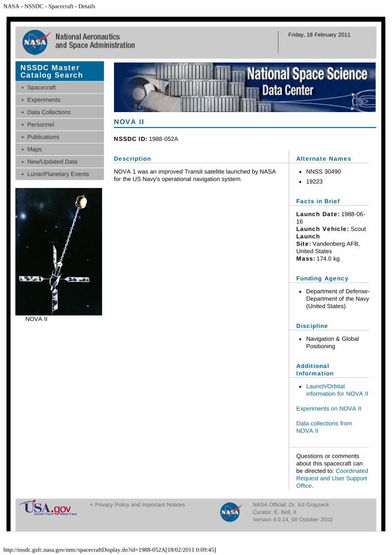
NASA - NSSDC - Spacecraft - Details
http://nssdc.gsfc.nasa.gov/nmc/spacecraftDisplay.do?id=1988-052A[18/02/2011 0:09:45]
Friday, 18 February 2011
Description
NOVA 1 was an improved Transit satellite launched by NASAfor the US Navy's operational navigation system.
NOVA II
NSSDC ID: 1988-052A
Alternate Names
NNSS 30490
19223
Facts in Brief
Launch Date: 1988-06-16Launch Vehicle: ScoutLaunchSite: Vandenberg AFB,United StatesMass: 174.0 kg
Funding Agency
Department of Defense-Department of the Navy(United States)
Discipline
Navigation & GlobalPositioning
AdditionalInformation
Launch/Orbitalinformation for NOVA II
Experiments on NOVA II
Data collections fromNOVA II
Questions or commentsabout this spacecraft canbe directed to: CoordinatedRequest and User SupportOffice.
NSSDC MasterCatalog Search
Spacecraft
Experiments
Data Collections
Personnel
Publications
Maps
New/Updated Data
Lunar/Planetary Events
NOVA II
+ Privacy Policy and Important Notices NASA Official: Dr. Ed GrayzeckCurator: E. Bell, IIVersion 4.0.14, 08 October 2010
NASA - NSSDC - Spacecraft - Details
http://nssdc.gsfc.nasa.gov/nmc/spacecraftDisplay.do?id=1988-087A[18/02/2011 0:10:42]
Friday, 18 February 2011
Description
Ofeq 1 (Horizon 1) was an experimental satellite launched byIsrael to demonstrate its capability to launch small satellites.Launch was from a site in the Negev desert. The spacecraftoperated successfully for nearly four months, until re-entry onJanuary 14, 1989. Solar panels provided a power capability of246 watts, but the average power consumption of thespacecraft was 53 watts. Spin period was one second.Telemetry was in the S-band, at 2.5 kbits/sec. This launch ona Shavit booster made Israel the eighth nation to launch asatellite on its own rocket.
Ofeq 1
NSSDC ID: 1988-087A
Alternate Names
Horizon 1
19519
Facts in Brief
Launch Date: 1988-09-19Launch Vehicle: ShavitLaunch Site: Palmahim,IsraelMass: 157.0 kg
Funding Agency
Israeli Space Agency(Israel)
Discipline
Engineering
AdditionalInformation
Launch/Orbitalinformation for Ofeq 1
Experiments on Ofeq 1
Data collections from Ofeq1
Questions or commentsabout this spacecraft canbe directed to: CoordinatedRequest and User SupportOffice.
NSSDC MasterCatalog Search
Spacecraft
Experiments
Data Collections
Personnel
Publications
Maps
New/Updated Data
Lunar/Planetary Events
+ Privacy Policy and Important Notices NASA Official: Dr. Ed GrayzeckCurator: E. Bell, IIVersion 4.0.14, 08 October 2010
NASA - NSSDC - Spacecraft - Details
http://nssdc.gsfc.nasa.gov/nmc/spacecraftDisplay.do?id=1988-056A[18/02/2011 0:11:37]
Friday, 18 February 2011
Description
The Okean series of satellites were all-weather radaroceanographic systems primarily designed to monitor sea-iceconditions in the Arctic seas. The payload included a side-looking radar, a scanning microwave radiometer, a nadir-viewing microwave spectrometer, optical scanners and a datacollection platform. The spacecraft was a stepped cylindricalpressurized bus 3 m high and 1.4 m diameter. It was 3-axisstabilized (nadir pointing, aided by a gravity gradient boom),had twin solar array spanning 4.82 m and an 11.8 m radarantenna mounted on the Earth-facing base. A primary featureof the Okean-series was direct Automatic Picture Transmission(APT) on 137.4 MHz of imagery to CIS APT stations as well asto foreign users. The on-board recorder had 6.5 minutecapacity and permitted coverage and transmission of a 470 x2750 km image by side-looking radar (SRL) and a 1930 x 2750km image by the multispectral scanner during a pass over anAPT station. The SRL operated at 3.2 cm with a swath width of450 km and ground resolution of 1200 x 1500 meters. TheMSU-M visible/near-IR multispectral scanner operated at 0.5 -0.6, 0.6 - 0.7, 0.7 - 0.8, and 0.8 - 1.1 microns with a swathwidth of 1900 km and ground resolution of 1900 meters. TheMSU-S visible/near-IR scanner operated at 0.6 - 0.7 and 0.8 -1.1 microns with a swath width of 1100 km and a groundresolution of 370 m. The MSU-SK operated at 0.8 - 1.1microns with a swath width of 1150 km and ground resolutionof 500 m. The non-scanning microwave instrument operatedat a frequency of 3 cm with a ground resolution of 12 m alongorbit and 6 m perpendicular to the orbit track. The Okeanpayload was flown on Cosmos 1500, Cosmos 1602, Cosmos1766, and Cosmos 1869 (radar failed), as well as Okean-1and Okean-2. See Karpov, A., "Hydrometeorological,Oceanographic and Earth-Resources Satellite SystemsOperated by the U.S.S.R.", Adv. Space Res., Vol. 11, No. 3,pp. 183-190, 1991.
Okean 1
NSSDC ID: 1988-056A
Alternate Names
19274
Facts in Brief
Launch Date: 1988-07-05LaunchVehicle: Tsiklon-3Launch Site: Plesetsk,U.S.S.RMass: 1950.0 kg
Funding Agency
Unknown (U.S.S.R)
Discipline
Earth Science
AdditionalInformation
Launch/Orbitalinformation for Okean 1
Experiments on Okean 1
Data collections fromOkean 1
Questions or commentsabout this spacecraft canbe directed to: CoordinatedRequest and User SupportOffice.
Personnel
Name Role Original Affiliation E-mail
NSSDC MasterCatalog Search
Spacecraft
Experiments
Data Collections
Personnel
Publications
Maps
New/Updated Data
Lunar/Planetary Events
+ Privacy Policy and Important Notices NASA Official: Dr. Ed GrayzeckCurator: E. Bell, II

NASA - NSSDC - Spacecraft - Details
http://nssdc.gsfc.nasa.gov/nmc/spacecraftDisplay.do?id=1988-051B[18/02/2011 0:12:46]
Friday, 18 February 2011
Description
Oscar 13 was launched from Kourou, French Guiana, for theUnited States. It was an international amateur radio satellitelaunched into geosynchronous orbit.
OSCAR 13
NSSDC ID: 1988-051B
Alternate Names
AMSAT 3C
19216
Facts in Brief
Launch Date: 1988-06-15Launch Vehicle: Ariane44LPLaunch Site: Kourou,French GuianaMass: 144.0 kg
Funding Agency
Radio Amateur SatelliteCorporation(International)
Discipline
Communications
AdditionalInformation
Launch/Orbitalinformation for OSCAR13
Experiments on OSCAR 13
Data collections fromOSCAR 13
Questions or commentsabout this spacecraft canbe directed to: CoordinatedRequest and User SupportOffice.
NSSDC MasterCatalog Search
Spacecraft
Experiments
Data Collections
Personnel
Publications
Maps
New/Updated Data
Lunar/Planetary Events
+ Privacy Policy and Important Notices NASA Official: Dr. Ed GrayzeckCurator: E. Bell, IIVersion 4.0.14, 08 October 2010
NASA - NSSDC - Spacecraft - Details
http://nssdc.gsfc.nasa.gov/nmc/spacecraftDisplay.do?id=1988-051C[18/02/2011 0:13:27]
Friday, 18 February 2011
Description
PAS 1 was launched from Kourou, French Guiana, for theUnited States.
PANAMSAT 1
NSSDC ID: 1988-051C
Alternate Names
Pan American Satellite 1
PAS 1
19217
Facts in Brief
Launch Date: 1988-06-15Launch Vehicle: Ariane44LPLaunch Site: Kourou,French GuianaMass: 1220.0 kg
Funding Agency
Pan American Satellite(United States)
Discipline
Communications
AdditionalInformation
Launch/Orbitalinformation forPANAMSAT 1
Experiments onPANAMSAT 1
Data collections fromPANAMSAT 1
Questions or commentsabout this spacecraft canbe directed to: CoordinatedRequest and User SupportOffice.
NSSDC MasterCatalog Search
Spacecraft
Experiments
Data Collections
Personnel
Publications
Maps
New/Updated Data
Lunar/Planetary Events
+ Privacy Policy and Important Notices NASA Official: Dr. Ed GrayzeckCurator: E. Bell, II
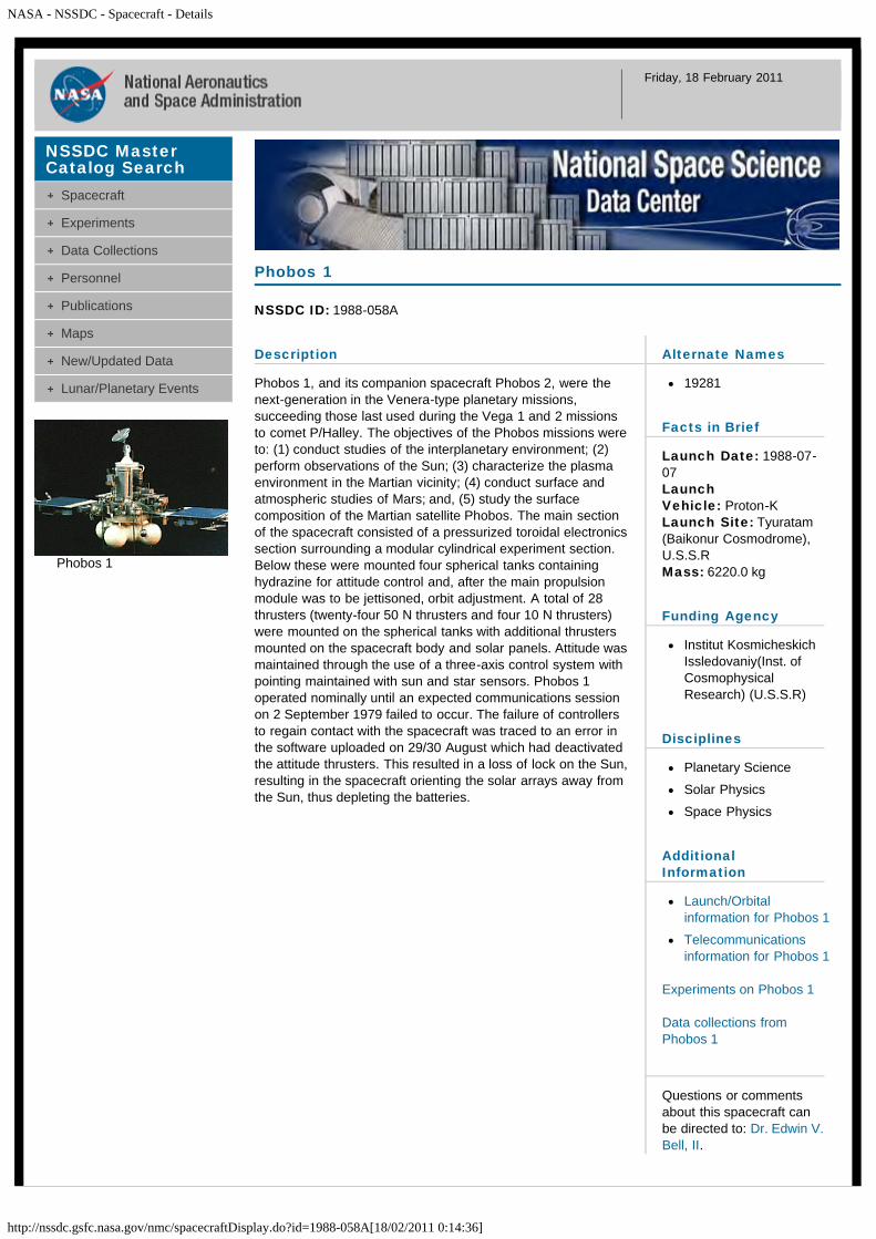
NASA - NSSDC - Spacecraft - Details
http://nssdc.gsfc.nasa.gov/nmc/spacecraftDisplay.do?id=1988-058A[18/02/2011 0:14:36]
Friday, 18 February 2011
Description
Phobos 1, and its companion spacecraft Phobos 2, were thenext-generation in the Venera-type planetary missions,succeeding those last used during the Vega 1 and 2 missionsto comet P/Halley. The objectives of the Phobos missions wereto: (1) conduct studies of the interplanetary environment; (2)perform observations of the Sun; (3) characterize the plasmaenvironment in the Martian vicinity; (4) conduct surface andatmospheric studies of Mars; and, (5) study the surfacecomposition of the Martian satellite Phobos. The main sectionof the spacecraft consisted of a pressurized toroidal electronicssection surrounding a modular cylindrical experiment section.Below these were mounted four spherical tanks containinghydrazine for attitude control and, after the main propulsionmodule was to be jettisoned, orbit adjustment. A total of 28thrusters (twenty-four 50 N thrusters and four 10 N thrusters)were mounted on the spherical tanks with additional thrustersmounted on the spacecraft body and solar panels. Attitude wasmaintained through the use of a three-axis control system withpointing maintained with sun and star sensors. Phobos 1operated nominally until an expected communications sessionon 2 September 1979 failed to occur. The failure of controllersto regain contact with the spacecraft was traced to an error inthe software uploaded on 29/30 August which had deactivatedthe attitude thrusters. This resulted in a loss of lock on the Sun,resulting in the spacecraft orienting the solar arrays away fromthe Sun, thus depleting the batteries.
Phobos 1
NSSDC ID: 1988-058A
Alternate Names
19281
Facts in Brief
Launch Date: 1988-07-07LaunchVehicle: Proton-KLaunch Site: Tyuratam(Baikonur Cosmodrome),U.S.S.RMass: 6220.0 kg
Funding Agency
Institut KosmicheskichIssledovaniy(Inst. ofCosmophysicalResearch) (U.S.S.R)
Disciplines
Planetary Science
Solar Physics
Space Physics
AdditionalInformation
Launch/Orbitalinformation for Phobos 1
Telecommunicationsinformation for Phobos 1
Experiments on Phobos 1
Data collections fromPhobos 1
Questions or commentsabout this spacecraft canbe directed to: Dr. Edwin V.Bell, II.
NSSDC MasterCatalog Search
Spacecraft
Experiments
Data Collections
Personnel
Publications
Maps
New/Updated Data
Lunar/Planetary Events
Phobos 1
NASA - NSSDC - Spacecraft - Details
http://nssdc.gsfc.nasa.gov/nmc/spacecraftDisplay.do?id=1988-058A[18/02/2011 0:14:36]
Personnel
Name Role Original Affiliation E-mail
Dr. Andrej I.Zakharov
ProjectScientist
Institut KosmicheskichIssledovaniya (IKI)
Selected References
Sagdeev, R. Z., et al., The Phobos project: Scientific objectives and experimental methods, Sov.Sci. Rev. E. Astrophys. Space Phys., 6, Pt. 1, 1-60, Aug. 1988.
+ Privacy Policy and Important Notices NASA Official: Dr. Ed GrayzeckCurator: E. Bell, IIVersion 4.0.14, 08 October 2010

NASA - NSSDC - Spacecraft - Details
http://nssdc.gsfc.nasa.gov/nmc/spacecraftDisplay.do?id=1988-059A[18/02/2011 0:15:48]
Friday, 18 February 2011
Description
Phobos 2, and its companion spacecraft Phobos 1, were thenext-generation in the Venera-type planetary missions,succeeding those last used during the Vega 1 and 2 missionsto comet P/Halley. The objectives of the Phobos missions wereto: (1) conduct studies of the interplanetary environment; (2)perform observations of the Sun; (3) characterize the plasmaenvironment in the Martian vicinity; (4) conduct surface andatmospheric studies of Mars; and, (5) study the surfacecomposition of the Martian satellite Phobos.
The main section of the spacecraft consisted of a pressurizedtoroidal electronics section surrounding a modular cylindricalexperiment section. Below these were mounted four sphericaltanks containing hydrazine for attitude control and, once themain propulsion module had been jettisoned, orbit adjustment.A total of 28 thrusters (twenty-four 50 N thrusters and four 10N thrusters) were mounted on the spherical tanks withadditional thrusters mounted on the spacecraft body and solarpanels. Attitude was maintained through the use of a three-axiscontrol system with pointing maintained with sun and starsensors.
Phobos 2 operated nominally throughout its cruise and Marsorbital insertion phases, gathering data on the Sun,interplanetary medium, Mars, and Phobos. Shortly before thefinal phase of the mission, during which the spacecraft was toapproach within 50 m of Phobos' surface and release twolanders, one a mobile `hopper', the other a stationary platform,contact with Phobos 2 was lost. The mission ended when thespacecraft signal failed to be successfully reacquired on 27March 1989. The cause of the failure was determined to be amalfunction of the on-board computer.
Phobos 2
NSSDC ID: 1988-059A
Alternate Names
19287
Facts in Brief
Launch Date: 1988-07-12LaunchVehicle: Proton-KLaunch Site: Tyuratam(Baikonur Cosmodrome),U.S.S.RMass: 2600.0 kg
Funding Agency
Institut KosmicheskichIssledovaniy(Inst. ofCosmophysicalResearch) (U.S.S.R)
Disciplines
Planetary Science
Solar Physics
Space Physics
AdditionalInformation
Launch/Orbitalinformation for Phobos 2
Telecommunicationsinformation for Phobos 2
Experiments on Phobos 2
Data collections fromPhobos 2
Questions or commentsabout this spacecraft canbe directed to: Dr. Edwin V.Bell, II.
NSSDC MasterCatalog Search
Spacecraft
Experiments
Data Collections
Personnel
Publications
Maps
New/Updated Data
Lunar/Planetary Events
Phobos 2

NASA - NSSDC - Spacecraft - Details
http://nssdc.gsfc.nasa.gov/nmc/spacecraftDisplay.do?id=1988-059A[18/02/2011 0:15:48]
Personnel
Name Role Original Affiliation E-mail
Dr. Andrej I.Zakharov
ProjectScientist
Institut KosmicheskichIssledovaniya (IKI)
Selected References
Sagdeev, R. Z., et al., The Phobos project: Scientific objectives and experimental methods, Sov.Sci. Rev. E. Astrophys. Space Phys., 6, Pt. 1, 1-60, Aug. 1988.
+ Privacy Policy and Important Notices NASA Official: Dr. Ed GrayzeckCurator: E. Bell, IIVersion 4.0.14, 08 October 2010
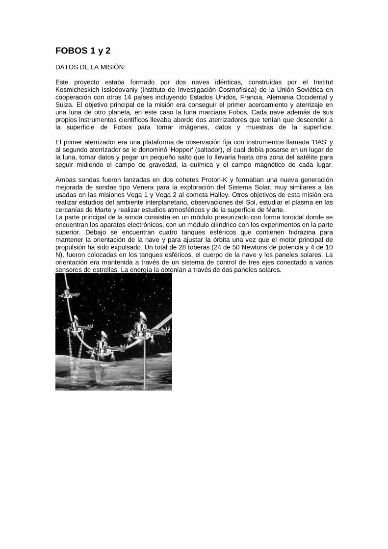
FOBOS 1 y 2 DATOS DE LA MISIÓN: Este proyecto estaba formado por dos naves idénticas, construidas por el Institut Kosmicheskich Issledovaniy (Instituto de Investigación Cosmofísica) de la Unión Soviética en cooperación con otros 14 países incluyendo Estados Unidos, Francia, Alemania Occidental y Suiza. El objetivo principal de la misión era conseguir el primer acercamiento y aterrizaje en una luna de otro planeta, en este caso la luna marciana Fobos. Cada nave además de sus propios instrumentos científicos llevaba abordo dos aterrizadores que tenían que descender a la superficie de Fobos para tomar imágenes, datos y muestras de la superficie. El primer aterrizador era una plataforma de observación fija con instrumentos llamada 'DAS' y al segundo aterrizador se le denominó 'Hopper' (saltador), el cual debía posarse en un lugar de la luna, tomar datos y pegar un pequeño salto que lo llevaría hasta otra zona del satélite para seguir midiendo el campo de gravedad, la química y el campo magnético de cada lugar. Ambas sondas fueron lanzadas en dos cohetes Proton-K y formaban una nueva generación mejorada de sondas tipo Venera para la exploración del Sistema Solar, muy similares a las usadas en las misiones Vega 1 y Vega 2 al cometa Halley. Otros objetivos de esta misión era realizar estudios del ambiente interplanetario, observaciones del Sol, estudiar el plasma en las cercanías de Marte y realizar estudios atmosféricos y de la superficie de Marte. La parte principal de la sonda consistía en un módulo presurizado con forma toroidal donde se encuentran los aparatos electrónicos, con un módulo cilíndrico con los experimentos en la parte superior. Debajo se encuentran cuatro tanques esféricos que contienen hidrazina para mantener la orientación de la nave y para ajustar la órbita una vez que el motor principal de propulsión ha sido expulsado. Un total de 28 toberas (24 de 50 Newtons de potencia y 4 de 10 N), fueron colocadas en los tanques esféricos, el cuerpo de la nave y los paneles solares. La orientación era mantenida a través de un sistema de control de tres ejes conectado a varios sensores de estrellas. La energía la obtenían a través de dos paneles solares.
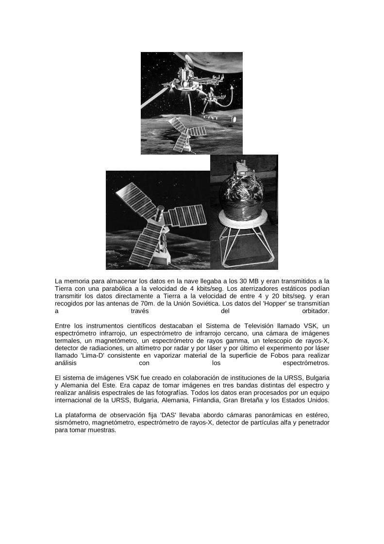
La memoria para almacenar los datos en la nave llegaba a los 30 MB y eran transmitidos a la Tierra con una parabólica a la velocidad de 4 kbits/seg. Los aterrizadores estáticos podían transmitir los datos directamente a Tierra a la velocidad de entre 4 y 20 bits/seg. y eran recogidos por las antenas de 70m. de la Unión Soviética. Los datos del 'Hopper' se transmitían a través del orbitador. Entre los instrumentos científicos destacaban el Sistema de Televisión llamado VSK, un espectrómetro infrarrojo, un espectrómetro de infrarrojo cercano, una cámara de imágenes termales, un magnetómetro, un espectrómetro de rayos gamma, un telescopio de rayos-X, detector de radiaciones, un altímetro por radar y por láser y por último el experimento por láser llamado 'Lima-D' consistente en vaporizar material de la superficie de Fobos para realizar análisis con los espectrómetros. El sistema de imágenes VSK fue creado en colaboración de instituciones de la URSS, Bulgaria y Alemania del Este. Era capaz de tomar imágenes en tres bandas distintas del espectro y realizar análisis espectrales de las fotografías. Todos los datos eran procesados por un equipo internacional de la URSS, Bulgaria, Alemania, Finlandia, Gran Bretaña y los Estados Unidos. La plataforma de observación fija 'DAS' llevaba abordo cámaras panorámicas en estéreo, sismómetro, magnetómetro, espectrómetro de rayos-X, detector de partículas alfa y penetrador para tomar muestras.
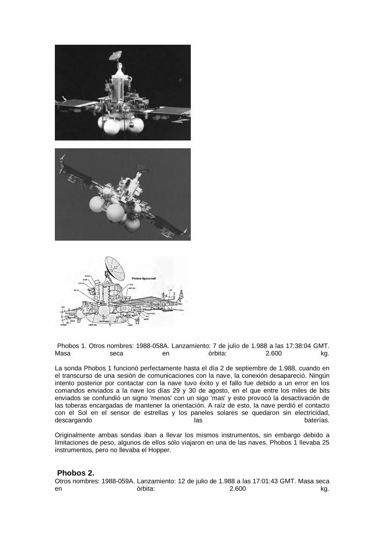
Phobos 1. Otros nombres: 1988-058A. Lanzamiento: 7 de julio de 1.988 a las 17:38:04 GMT.
Masa seca en órbita: 2.600 kg. La sonda Phobos 1 funcionó perfectamente hasta el día 2 de septiembre de 1.988, cuando en el transcurso de una sesión de comunicaciones con la nave, la conexión desapareció. Ningún intento posterior por contactar con la nave tuvo éxito y el fallo fue debido a un error en los comandos enviados a la nave los días 29 y 30 de agosto, en el que entre los miles de bits enviados se confundió un signo 'menos' con un sigo 'mas' y esto provocó la desactivación de las toberas encargadas de mantener la orientación. A raíz de esto, la nave perdió el contacto con el Sol en el sensor de estrellas y los paneles solares se quedaron sin electricidad, descargando las baterías. Originalmente ambas sondas iban a llevar los mismos instrumentos, sin embargo debido a limitaciones de peso, algunos de ellos sólo viajaron en una de las naves. Phobos 1 llevaba 25 instrumentos, pero no llevaba el Hopper. Phobos 2.
Otros nombres: 1988-059A. Lanzamiento: 12 de julio de 1.988 a las 17:01:43 GMT. Masa seca en órbita: 2.600 kg.
La sonda funcionó con normalidad a lo largo de su viaje hasta la llegada a Marte y su fase de inserción orbital alrededor del planeta (el 29 de enero de 1.989), consiguiendo numerosos datos del Sol, el medio interplanetario, Marte y Fobos. Justo antes de la fase final de la misión, cuando la nave debía de acercarse a sólo 50 metros de la superficie de Fobos y soltar dos aterrizadores, uno de ellos móvil y el otro una plataforma estacionaria, se perdió el contacto con la nave (27 de marzo de 1.989). Como causa de la pérdida se determinó un fallo en la computadora de la sonda. Antes de llegar a Marte, la sonda tenía ya numerosos problemas. A finales de 1.988 la nave había perdido dos de los tres canales de televisión (del Sistema VSK) y los datos los mandaba por el transmisor de repuesto. El experimento de plasma desarrollado en los Estados Unidos y Bulgaria estaba sobrecalentado continuamente y afectaba a otros equipos. En un total de 52 órbitas a Marte nos mandó un total de 37 fotografías. Los resultados científicos obtenidos no llegaron a completarse por lo que la misión no se puede considerar un éxito.

NASA - NSSDC - Spacecraft - Details
http://nssdc.gsfc.nasa.gov/nmc/spacecraftDisplay.do?id=1988-014A[18/02/2011 0:16:44]
Friday, 18 February 2011
Description
PRC 22 was launched March 7, 1988, by the People'sRepublic of China. The final position of this quasi-synchronouscommunications satellite was fixed at 87.5 deg east longitudeabove the equator in early April, 1988.
PRC 22
NSSDC ID: 1988-014A
Alternate Names
STTW-2
18922
Facts in Brief
Launch Date: 1988-03-07Launch Vehicle: LongMarch 3Launch Site: Xichang,Peoples Republic of ChinaMass: 900.0 kg
Funding Agency
Unknown (PeoplesRepublic of China)
Discipline
Communications
AdditionalInformation
Launch/Orbitalinformation for PRC 22
Experiments on PRC 22
Data collections from PRC22
Questions or commentsabout this spacecraft canbe directed to: CoordinatedRequest and User SupportOffice.
NSSDC MasterCatalog Search
Spacecraft
Experiments
Data Collections
Personnel
Publications
Maps
New/Updated Data
Lunar/Planetary Events
+ Privacy Policy and Important Notices NASA Official: Dr. Ed GrayzeckCurator: E. Bell, IIVersion 4.0.14, 08 October 2010

NASA - NSSDC - Spacecraft - Details
http://nssdc.gsfc.nasa.gov/nmc/spacecraftDisplay.do?id=1988-067A[18/02/2011 0:17:08]
Friday, 18 February 2011
Description
PRC 23, a retrievable satellite with experimental devices fromThe Federal Republic of Germany on board, conductedscientific exploration and technological experiments and thenreturned to earth.
PRC 23
NSSDC ID: 1988-067A
Alternate Names
FSW-1 2
19368
Facts in Brief
Launch Date: 1988-08-05Launch Vehicle: LongMarch 2CLaunch Site: Jiuquan,Peoples Republic of ChinaMass: 1700.0 kg
Funding Agency
Unknown (PeoplesRepublic of China)
Discipline
Microgravity
AdditionalInformation
Launch/Orbitalinformation for PRC 23
Experiments on PRC 23
Data collections from PRC23
Questions or commentsabout this spacecraft canbe directed to: CoordinatedRequest and User SupportOffice.
NSSDC MasterCatalog Search
Spacecraft
Experiments
Data Collections
Personnel
Publications
Maps
New/Updated Data
Lunar/Planetary Events
+ Privacy Policy and Important Notices NASA Official: Dr. Ed GrayzeckCurator: E. Bell, IIVersion 4.0.14, 08 October 2010

NASA - NSSDC - Spacecraft - Details
http://nssdc.gsfc.nasa.gov/nmc/spacecraftDisplay.do?id=1988-111A[18/02/2011 0:17:33]
Friday, 18 February 2011
Description
PRC 25 was launched by the People's Republic of China. Thequasi-geosynchronous telecommunications satellite wasexpected to be fixed over the equator at 110.5 deg eastlongitude.
PRC 25
NSSDC ID: 1988-111A
Alternate Names
STTW-3
19710
Facts in Brief
Launch Date: 1988-12-22Launch Vehicle: LongMarch 3Launch Site: Xichang,Peoples Republic of ChinaMass: 900.0 kg
Funding Agency
Unknown (PeoplesRepublic of China)
Discipline
Communications
AdditionalInformation
Launch/Orbitalinformation for PRC 25
Experiments on PRC 25
Data collections from PRC25
Questions or commentsabout this spacecraft canbe directed to: CoordinatedRequest and User SupportOffice.
NSSDC MasterCatalog Search
Spacecraft
Experiments
Data Collections
Personnel
Publications
Maps
New/Updated Data
Lunar/Planetary Events
+ Privacy Policy and Important Notices NASA Official: Dr. Ed GrayzeckCurator: E. Bell, IIVersion 4.0.14, 08 October 2010
NASA - NSSDC - Spacecraft - Details
http://nssdc.gsfc.nasa.gov/nmc/spacecraftDisplay.do?id=1988-003A[18/02/2011 0:18:01]
Friday, 18 February 2011
Description
Progress 34 carried expendable materials and various otherloads for the orbit station Mir.
Progress 34
NSSDC ID: 1988-003A
Alternate Names
18795
Facts in Brief
Launch Date: 1988-01-20LaunchVehicle: Proton-KLaunch Site: Tyuratam(Baikonur Cosmodrome),U.S.S.RMass: 7240.0 kg
Funding Agency
Unknown (U.S.S.R)
Discipline
Resupply/Refurbishment/Repair
AdditionalInformation
Launch/Orbitalinformation for Progress34
Experiments on Progress34
Data collections fromProgress 34
Questions or commentsabout this spacecraft canbe directed to: CoordinatedRequest and User SupportOffice.
NSSDC MasterCatalog Search
Spacecraft
Experiments
Data Collections
Personnel
Publications
Maps
New/Updated Data
Lunar/Planetary Events
+ Privacy Policy and Important Notices NASA Official: Dr. Ed GrayzeckCurator: E. Bell, IIVersion 4.0.14, 08 October 2010
NASA - NSSDC - Spacecraft - Details
http://nssdc.gsfc.nasa.gov/nmc/spacecraftDisplay.do?id=1988-024A[18/02/2011 0:18:46]
Friday, 18 February 2011
Description
Progress 35 carried expendable materials and various otherloads for the orbit station Mir.
Progress 35
NSSDC ID: 1988-024A
Alternate Names
18992
Facts in Brief
Launch Date: 1988-03-23Launch Vehicle: SoyuzLaunch Site: Tyuratam(Baikonur Cosmodrome),U.S.S.RMass: 7240.0 kg
Funding Agency
Unknown (U.S.S.R)
Discipline
Resupply/Refurbishment/Repair
AdditionalInformation
Launch/Orbitalinformation for Progress35
Experiments on Progress35
Data collections fromProgress 35
Questions or commentsabout this spacecraft canbe directed to: CoordinatedRequest and User SupportOffice.
NSSDC MasterCatalog Search
Spacecraft
Experiments
Data Collections
Personnel
Publications
Maps
New/Updated Data
Lunar/Planetary Events
+ Privacy Policy and Important Notices NASA Official: Dr. Ed GrayzeckCurator: E. Bell, IIVersion 4.0.14, 08 October 2010

NASA - NSSDC - Spacecraft - Details
http://nssdc.gsfc.nasa.gov/nmc/spacecraftDisplay.do?id=1988-038A[18/02/2011 0:19:23]
Friday, 18 February 2011
Description
Progress 36 carried expendable materials and various loadsfor the orbit station Mir.
Progress 36
NSSDC ID: 1988-038A
Alternate Names
19117
Facts in Brief
Launch Date: 1988-05-13Launch Vehicle: SoyuzLaunch Site: Tyuratam(Baikonur Cosmodrome),U.S.S.RMass: 7240.0 kg
Funding Agency
Unknown (U.S.S.R)
Discipline
Resupply/Refurbishment/Repair
AdditionalInformation
Launch/Orbitalinformation for Progress36
Experiments on Progress36
Data collections fromProgress 36
Questions or commentsabout this spacecraft canbe directed to: CoordinatedRequest and User SupportOffice.
NSSDC MasterCatalog Search
Spacecraft
Experiments
Data Collections
Personnel
Publications
Maps
New/Updated Data
Lunar/Planetary Events
+ Privacy Policy and Important Notices NASA Official: Dr. Ed GrayzeckCurator: E. Bell, IIVersion 4.0.14, 08 October 2010

NASA - NSSDC - Spacecraft - Details
http://nssdc.gsfc.nasa.gov/nmc/spacecraftDisplay.do?id=1988-061A[18/02/2011 0:20:05]
Friday, 18 February 2011
Description
Progress 37 carried expendable materials and various loadsfor the orbital station Mir.
Progress 37
NSSDC ID: 1988-061A
Alternate Names
19322
Facts in Brief
Launch Date: 1988-07-18Launch Vehicle: SoyuzLaunch Site: Tyuratam(Baikonur Cosmodrome),U.S.S.RMass: 7240.0 kg
Funding Agency
Unknown (U.S.S.R)
Discipline
Resupply/Refurbishment/Repair
AdditionalInformation
Launch/Orbitalinformation for Progress37
Experiments on Progress37
Data collections fromProgress 37
Questions or commentsabout this spacecraft canbe directed to: CoordinatedRequest and User SupportOffice.
NSSDC MasterCatalog Search
Spacecraft
Experiments
Data Collections
Personnel
Publications
Maps
New/Updated Data
Lunar/Planetary Events
+ Privacy Policy and Important Notices NASA Official: Dr. Ed GrayzeckCurator: E. Bell, IIVersion 4.0.14, 08 October 2010
NASA - NSSDC - Spacecraft - Details
http://nssdc.gsfc.nasa.gov/nmc/spacecraftDisplay.do?id=1988-083A[18/02/2011 0:23:25]
Friday, 18 February 2011
Description
Progress 38 was launched by the USSR and carriedexpendable material and various cargos for the orbital stationMir.
Progress 38
NSSDC ID: 1988-083A
Alternate Names
19486
Facts in Brief
Launch Date: 1988-09-09Launch Vehicle: SoyuzLaunch Site: Tyuratam(Baikonur Cosmodrome),U.S.S.RMass: 7240.0 kg
Funding Agency
Unknown (U.S.S.R)
Discipline
Resupply/Refurbishment/Repair
AdditionalInformation
Launch/Orbitalinformation for Progress38
Experiments on Progress38
Data collections fromProgress 38
Questions or commentsabout this spacecraft canbe directed to: CoordinatedRequest and User SupportOffice.
NSSDC MasterCatalog Search
Spacecraft
Experiments
Data Collections
Personnel
Publications
Maps
New/Updated Data
Lunar/Planetary Events
+ Privacy Policy and Important Notices NASA Official: Dr. Ed GrayzeckCurator: E. Bell, IIVersion 4.0.14, 08 October 2010
NASA - NSSDC - Spacecraft - Details
http://nssdc.gsfc.nasa.gov/nmc/spacecraftDisplay.do?id=1988-114A[19/02/2011 0:31:14]
Saturday, 19 February 2011
Description
Progress 39 was launched by the USSR and carriedexpendable material and various cargo for the orbital spacestation Mir.
Progress 39
NSSDC ID: 1988-114A
Alternate Names
19728
Facts in Brief
Launch Date: 1988-12-25Launch Vehicle: SoyuzLaunch Site: Tyuratam(Baikonur Cosmodrome),U.S.S.RMass: 7240.0 kg
Funding Agency
Unknown (U.S.S.R)
Discipline
Resupply/Refurbishment/Repair
AdditionalInformation
Launch/Orbitalinformation for Progress39
Experiments on Progress39
Data collections fromProgress 39
Questions or commentsabout this spacecraft canbe directed to: CoordinatedRequest and User SupportOffice.
NSSDC MasterCatalog Search
Spacecraft
Experiments
Data Collections
Personnel
Publications
Maps
New/Updated Data
Lunar/Planetary Events
+ Privacy Policy and Important Notices NASA Official: Dr. Ed GrayzeckCurator: E. Bell, IIVersion 4.0.14, 08 October 2010
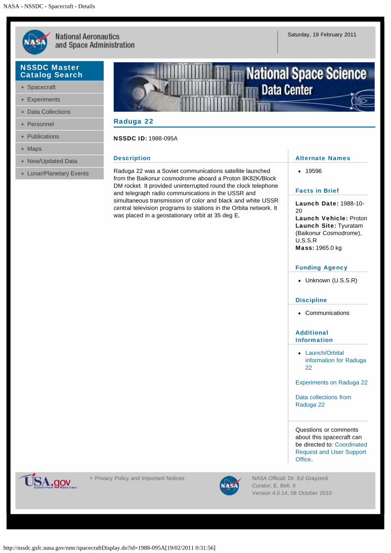
NASA - NSSDC - Spacecraft - Details
http://nssdc.gsfc.nasa.gov/nmc/spacecraftDisplay.do?id=1988-095A[19/02/2011 0:31:56]
Saturday, 19 February 2011
Description
Raduga 22 was a Soviet communications satellite launchedfrom the Baikonur cosmodrome aboard a Proton 8K82K/BlockDM rocket. It provided uninterrupted round the clock telephoneand telegraph radio communications in the USSR andsimultaneous transmission of color and black and white USSRcentral television programs to stations in the Orbita network. Itwas placed in a geostationary orbit at 35 deg E.
Raduga 22
NSSDC ID: 1988-095A
Alternate Names
19596
Facts in Brief
Launch Date: 1988-10-20Launch Vehicle: ProtonLaunch Site: Tyuratam(Baikonur Cosmodrome),U.S.S.RMass: 1965.0 kg
Funding Agency
Unknown (U.S.S.R)
Discipline
Communications
AdditionalInformation
Launch/Orbitalinformation for Raduga22
Experiments on Raduga 22
Data collections fromRaduga 22
Questions or commentsabout this spacecraft canbe directed to: CoordinatedRequest and User SupportOffice.
NSSDC MasterCatalog Search
Spacecraft
Experiments
Data Collections
Personnel
Publications
Maps
New/Updated Data
Lunar/Planetary Events
+ Privacy Policy and Important Notices NASA Official: Dr. Ed GrayzeckCurator: E. Bell, IIVersion 4.0.14, 08 October 2010
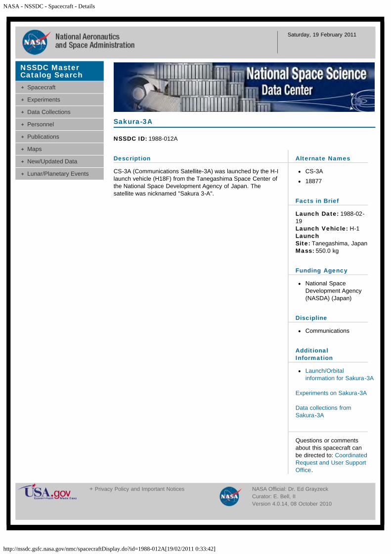
NASA - NSSDC - Spacecraft - Details
http://nssdc.gsfc.nasa.gov/nmc/spacecraftDisplay.do?id=1988-012A[19/02/2011 0:33:42]
Saturday, 19 February 2011
Description
CS-3A (Communications Satellite-3A) was launched by the H-Ilaunch vehicle (H18F) from the Tanegashima Space Center ofthe National Space Development Agency of Japan. Thesatellite was nicknamed "Sakura 3-A".
Sakura-3A
NSSDC ID: 1988-012A
Alternate Names
CS-3A
18877
Facts in Brief
Launch Date: 1988-02-19Launch Vehicle: H-1LaunchSite: Tanegashima, JapanMass: 550.0 kg
Funding Agency
National SpaceDevelopment Agency(NASDA) (Japan)
Discipline
Communications
AdditionalInformation
Launch/Orbitalinformation for Sakura-3A
Experiments on Sakura-3A
Data collections fromSakura-3A
Questions or commentsabout this spacecraft canbe directed to: CoordinatedRequest and User SupportOffice.
NSSDC MasterCatalog Search
Spacecraft
Experiments
Data Collections
Personnel
Publications
Maps
New/Updated Data
Lunar/Planetary Events
+ Privacy Policy and Important Notices NASA Official: Dr. Ed GrayzeckCurator: E. Bell, IIVersion 4.0.14, 08 October 2010

NASA - NSSDC - Spacecraft - Details
http://nssdc.gsfc.nasa.gov/nmc/spacecraftDisplay.do?id=1988-086A[19/02/2011 0:35:13]
Saturday, 19 February 2011
Description
CS-3B (Communications Satellite 3B) was launched from theTanegashima Space Center, Japan. It was placed in anelliptical orbit and was moved at a later stage to a stationaryorbit above the equator at 136 deg east longitude over thewestern part of New Guinea.
Sakura-3B
NSSDC ID: 1988-086A
Alternate Names
CS-3B
19508
Facts in Brief
Launch Date: 1988-09-16Launch Vehicle: H-1LaunchSite: Tanegashima, JapanMass: 550.0 kg
Funding Agency
National SpaceDevelopment Agency(NASDA) (Japan)
Discipline
Communications
AdditionalInformation
Launch/Orbitalinformation for Sakura-3B
Experiments on Sakura-3B
Data collections fromSakura-3B
Questions or commentsabout this spacecraft canbe directed to: CoordinatedRequest and User SupportOffice.
NSSDC MasterCatalog Search
Spacecraft
Experiments
Data Collections
Personnel
Publications
Maps
New/Updated Data
Lunar/Planetary Events
+ Privacy Policy and Important Notices NASA Official: Dr. Ed GrayzeckCurator: E. Bell, IIVersion 4.0.14, 08 October 2010
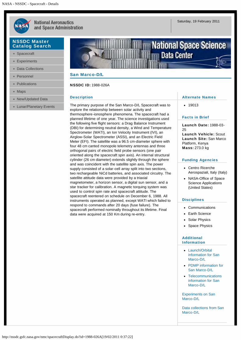
NASA - NSSDC - Spacecraft - Details
http://nssdc.gsfc.nasa.gov/nmc/spacecraftDisplay.do?id=1988-026A[19/02/2011 0:37:22]
Saturday, 19 February 2011
Description
The primary purpose of the San Marco-D/L Spacecraft was toexplore the relationship between solar activity andthermosphere-ionosphere phenomena. The spacecraft had aplanned lifetime of one year. The science investigations usedthe following five flight sensors: a Drag Balance Instrument(DBI) for determining neutral density, a Wind and TemperatureSpectrometer (WATI), an Ion Velocity Instrument (IVI), anAirglow-Solar Spectrometer (ASSI), and an Electric FieldMeter (EFI). The satellite was a 96.5 cm-diameter sphere withfour 48 cm canted monopole telemetry antennas and threeorthogonal pairs of electric field probe sensors (one pairoriented along the spacecraft spin axis). An internal structuralcylinder (26 cm diameter) extends slightly through the sphereand was coincident with the satellite spin axis. The powersupply consisted of a solar-cell array split into two sections,two rechargeable NiCd batteries, and associated circuitry. Thesatellite attitude data were provided by a triaxialmagnetometer, a horizon sensor, a digital sun sensor, and astar tracker for calibration. A magnetic torquing system wasused to control spin rate and spacecraft attitude. Thespacecraft reentered on schedule on December 6, 1988. Allinstruments operated as planned, except WATI which failed torespond to commands after 20 days (fuse failure). Thespacecraft performed nominally throughout its lifetime. Finaldata were acquired at 150 Km during re-entry.
San Marco-D/L
NSSDC ID: 1988-026A
Alternate Names
19013
Facts in Brief
Launch Date: 1988-03-25Launch Vehicle: ScoutLaunch Site: San MarcoPlatform, KenyaMass: 273.0 kg
Funding Agencies
Centro RicercheAerospaziali, Italy (Italy)
NASA-Office of SpaceScience Applications(United States)
Disciplines
Communications
Earth Science
Solar Physics
Space Physics
AdditionalInformation
Launch/Orbitalinformation for SanMarco-D/L
PDMP information forSan Marco-D/L
Telecommunicationsinformation for SanMarco-D/L
Experiments on SanMarco-D/L
Data collections from SanMarco-D/L
NSSDC MasterCatalog Search
Spacecraft
Experiments
Data Collections
Personnel
Publications
Maps
New/Updated Data
Lunar/Planetary Events
NASA - NSSDC - Spacecraft - Details
http://nssdc.gsfc.nasa.gov/nmc/spacecraftDisplay.do?id=1988-026A[19/02/2011 0:37:22]
Questions or commentsabout this spacecraft canbe directed to: Dr. Dieter K.Bilitza.
Personnel
Name Role Original Affiliation E-mail
Mr. Ronald E. Adkins Project Manager NASA Goddard Space Flight Center
Dr. Nelson W. Spencer Project Scientist NASA Goddard Space Flight Center
Dr. M. Diruscio General Contact Universita degli Studi di Roma
Other Sources of San Marco D/L Data/Information
San Marco D/L Project page
+ Privacy Policy and Important Notices NASA Official: Dr. Ed GrayzeckCurator: E. Bell, IIVersion 4.0.14, 08 October 2010

NASA - NSSDC - Spacecraft - Details
http://nssdc.gsfc.nasa.gov/nmc/spacecraftDisplay.do?id=1988-081B[19/02/2011 0:39:17]
Saturday, 19 February 2011
Description
SBS 5, a telecommunications satellite, was launched fromKourou, French Guiana, for the United States.
SBS 5
NSSDC ID: 1988-081B
Alternate Names
Satellite BusinessSystems 5
19484
Facts in Brief
Launch Date: 1988-09-08Launch Vehicle: Ariane3Launch Site: Kourou,French GuianaMass: 1239.0 kg
Funding Agency
Pan American Satellite(United States)
Discipline
Communications
AdditionalInformation
Launch/Orbitalinformation for SBS 5
Experiments on SBS 5
Data collections from SBS5
Questions or commentsabout this spacecraft canbe directed to: CoordinatedRequest and User SupportOffice.
NSSDC MasterCatalog Search
Spacecraft
Experiments
Data Collections
Personnel
Publications
Maps
New/Updated Data
Lunar/Planetary Events
+ Privacy Policy and Important Notices NASA Official: Dr. Ed GrayzeckCurator: E. Bell, IIVersion 4.0.14, 08 October 2010

NASA - NSSDC - Spacecraft - Details
http://nssdc.gsfc.nasa.gov/nmc/spacecraftDisplay.do?id=1988-109A[19/02/2011 0:40:42]
Saturday, 19 February 2011
Description
SKYNET 4B was a British military telecommunications satellitelaunched from Kourou, French Guiana.
Skynet 4B
NSSDC ID: 1988-109A
Alternate Names
19687
Facts in Brief
Launch Date: 1988-12-11Launch Vehicle: Ariane44LPLaunch Site: Kourou,French GuianaMass: 1429.1 kg
Funding Agency
Ministry of Defence, UK(United Kingdom)
Discipline
Communications
AdditionalInformation
Launch/Orbitalinformation for Skynet 4B
Experiments on Skynet 4B
Data collections fromSkynet 4B
Questions or commentsabout this spacecraft canbe directed to: CoordinatedRequest and User SupportOffice.
NSSDC MasterCatalog Search
Spacecraft
Experiments
Data Collections
Personnel
Publications
Maps
New/Updated Data
Lunar/Planetary Events
+ Privacy Policy and Important Notices NASA Official: Dr. Ed GrayzeckCurator: E. Bell, IIVersion 4.0.14, 08 October 2010
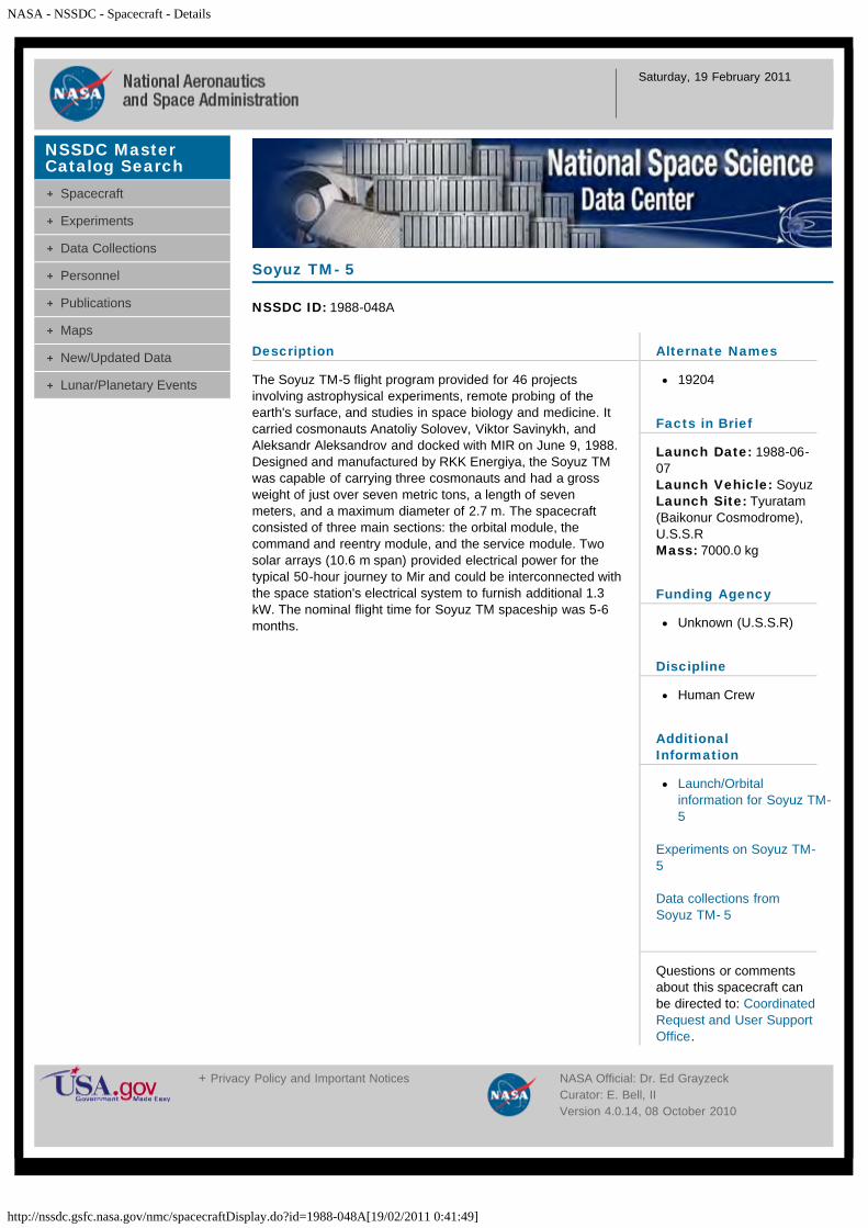
NASA - NSSDC - Spacecraft - Details
http://nssdc.gsfc.nasa.gov/nmc/spacecraftDisplay.do?id=1988-048A[19/02/2011 0:41:49]
Saturday, 19 February 2011
Description
The Soyuz TM-5 flight program provided for 46 projectsinvolving astrophysical experiments, remote probing of theearth's surface, and studies in space biology and medicine. Itcarried cosmonauts Anatoliy Solovev, Viktor Savinykh, andAleksandr Aleksandrov and docked with MIR on June 9, 1988.Designed and manufactured by RKK Energiya, the Soyuz TMwas capable of carrying three cosmonauts and had a grossweight of just over seven metric tons, a length of sevenmeters, and a maximum diameter of 2.7 m. The spacecraftconsisted of three main sections: the orbital module, thecommand and reentry module, and the service module. Twosolar arrays (10.6 m span) provided electrical power for thetypical 50-hour journey to Mir and could be interconnected withthe space station's electrical system to furnish additional 1.3kW. The nominal flight time for Soyuz TM spaceship was 5-6months.
Soyuz TM- 5
NSSDC ID: 1988-048A
Alternate Names
19204
Facts in Brief
Launch Date: 1988-06-07Launch Vehicle: SoyuzLaunch Site: Tyuratam(Baikonur Cosmodrome),U.S.S.RMass: 7000.0 kg
Funding Agency
Unknown (U.S.S.R)
Discipline
Human Crew
AdditionalInformation
Launch/Orbitalinformation for Soyuz TM-5
Experiments on Soyuz TM-5
Data collections fromSoyuz TM- 5
Questions or commentsabout this spacecraft canbe directed to: CoordinatedRequest and User SupportOffice.
NSSDC MasterCatalog Search
Spacecraft
Experiments
Data Collections
Personnel
Publications
Maps
New/Updated Data
Lunar/Planetary Events
+ Privacy Policy and Important Notices NASA Official: Dr. Ed GrayzeckCurator: E. Bell, IIVersion 4.0.14, 08 October 2010
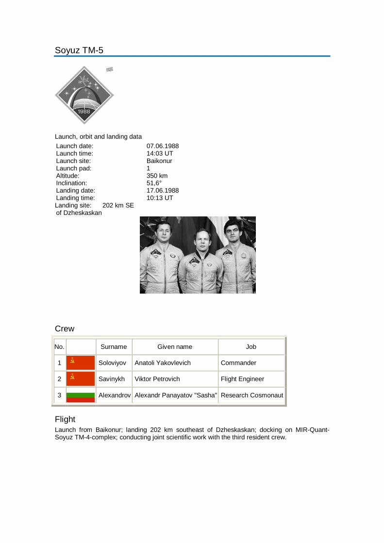
Soyuz TM-5
Launch, orbit and landing data Launch date: 07.06.1988 Launch time: 14:03 UT Launch site: Baikonur Launch pad: 1 Altitude: 350 km Inclination: 51,6° Landing date: 17.06.1988 Landing time: 10:13 UT Landing site: 202 km SE of Dzheskaskan
Crew
No. Surname Given name Job
1 Soloviyov Anatoli Yakovlevich Commander
2 Savinykh Viktor Petrovich Flight Engineer
3 Alexandrov Alexandr Panayatov "Sasha" Research Cosmonaut
Flight Launch from Baikonur; landing 202 km southeast of Dzheskaskan; docking on MIR-Quant-Soyuz TM-4-complex; conducting joint scientific work with the third resident crew.
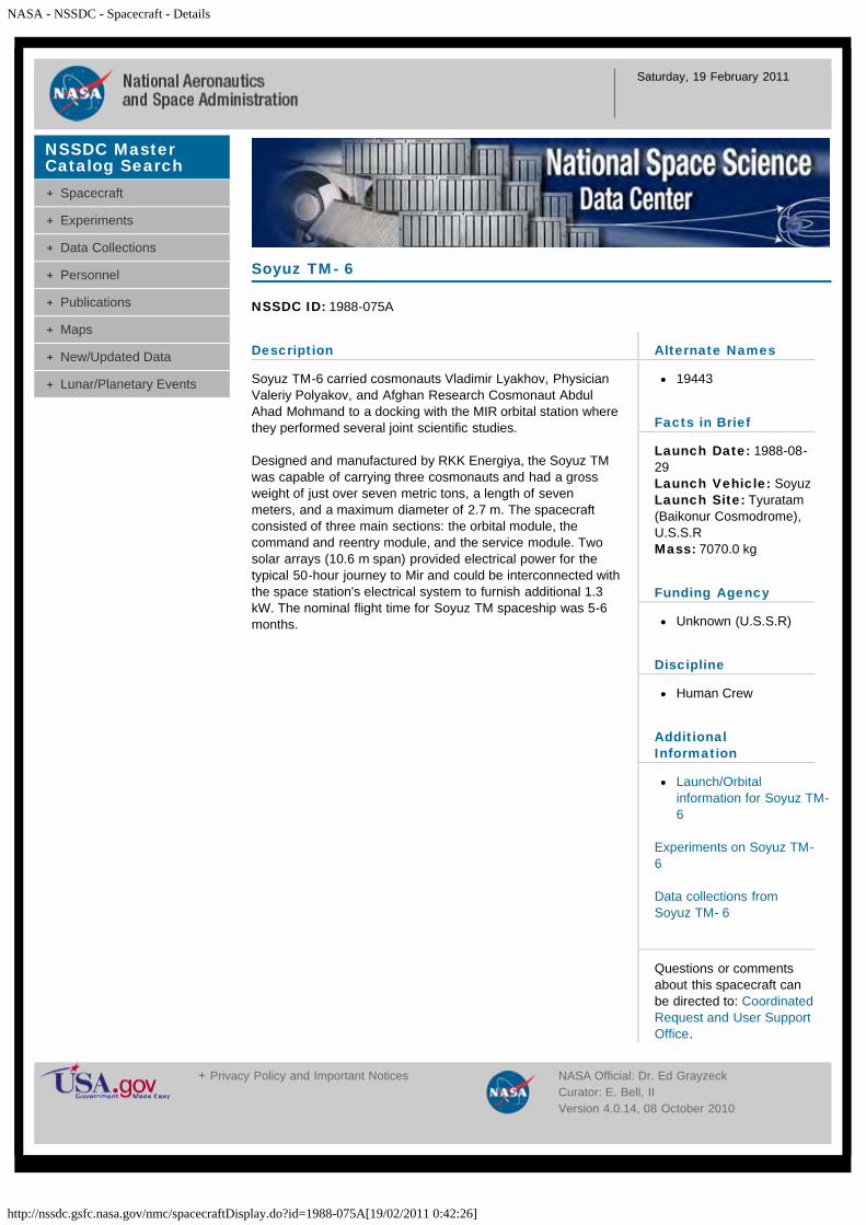
NASA - NSSDC - Spacecraft - Details
http://nssdc.gsfc.nasa.gov/nmc/spacecraftDisplay.do?id=1988-075A[19/02/2011 0:42:26]
Saturday, 19 February 2011
Description
Soyuz TM-6 carried cosmonauts Vladimir Lyakhov, PhysicianValeriy Polyakov, and Afghan Research Cosmonaut AbdulAhad Mohmand to a docking with the MIR orbital station wherethey performed several joint scientific studies.
Designed and manufactured by RKK Energiya, the Soyuz TMwas capable of carrying three cosmonauts and had a grossweight of just over seven metric tons, a length of sevenmeters, and a maximum diameter of 2.7 m. The spacecraftconsisted of three main sections: the orbital module, thecommand and reentry module, and the service module. Twosolar arrays (10.6 m span) provided electrical power for thetypical 50-hour journey to Mir and could be interconnected withthe space station's electrical system to furnish additional 1.3kW. The nominal flight time for Soyuz TM spaceship was 5-6months.
Soyuz TM- 6
NSSDC ID: 1988-075A
Alternate Names
19443
Facts in Brief
Launch Date: 1988-08-29Launch Vehicle: SoyuzLaunch Site: Tyuratam(Baikonur Cosmodrome),U.S.S.RMass: 7070.0 kg
Funding Agency
Unknown (U.S.S.R)
Discipline
Human Crew
AdditionalInformation
Launch/Orbitalinformation for Soyuz TM-6
Experiments on Soyuz TM-6
Data collections fromSoyuz TM- 6
Questions or commentsabout this spacecraft canbe directed to: CoordinatedRequest and User SupportOffice.
NSSDC MasterCatalog Search
Spacecraft
Experiments
Data Collections
Personnel
Publications
Maps
New/Updated Data
Lunar/Planetary Events
+ Privacy Policy and Important Notices NASA Official: Dr. Ed GrayzeckCurator: E. Bell, IIVersion 4.0.14, 08 October 2010
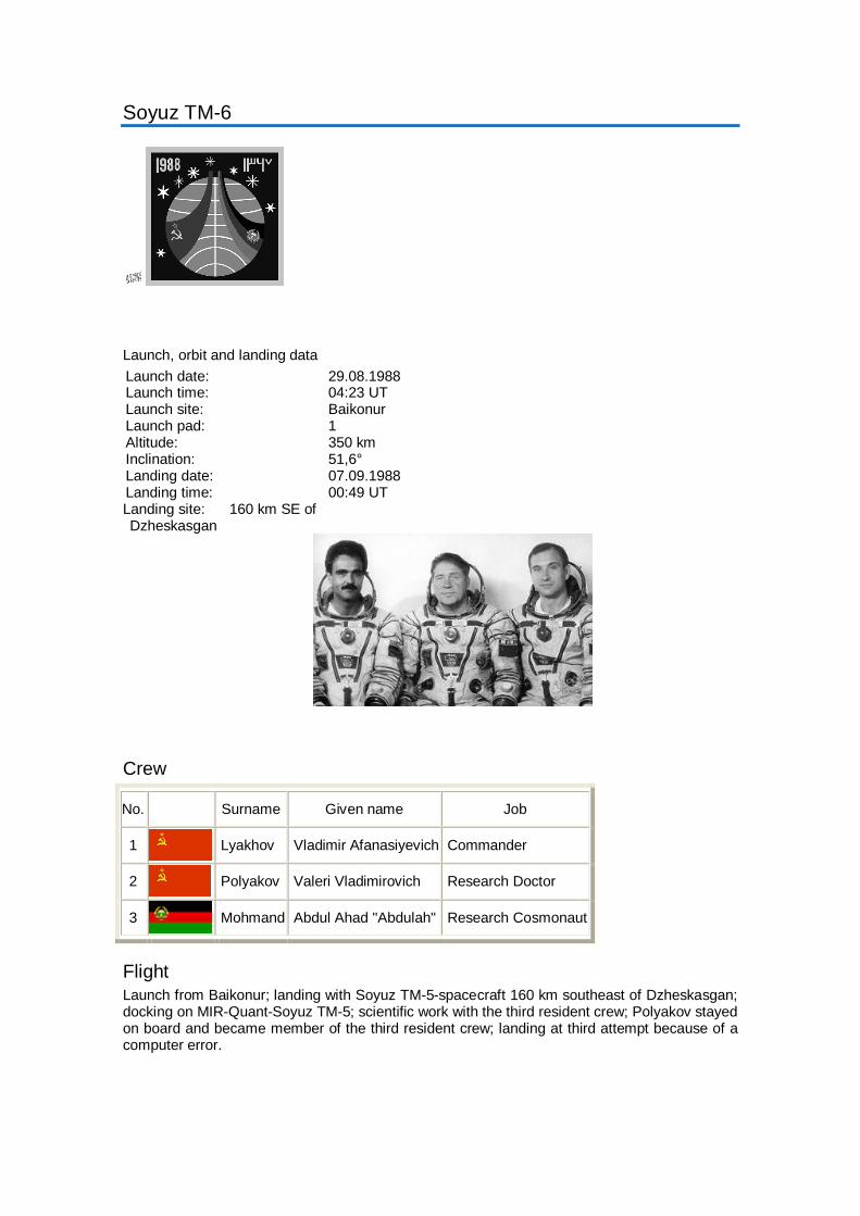
Soyuz TM-6
Launch, orbit and landing data Launch date: 29.08.1988 Launch time: 04:23 UT Launch site: Baikonur Launch pad: 1 Altitude: 350 km Inclination: 51,6° Landing date: 07.09.1988 Landing time: 00:49 UT Landing site: 160 km SE of Dzheskasgan
Crew
No. Surname Given name Job
1 Lyakhov Vladimir Afanasiyevich Commander
2 Polyakov Valeri Vladimirovich Research Doctor
3 Mohmand Abdul Ahad "Abdulah" Research Cosmonaut
Flight Launch from Baikonur; landing with Soyuz TM-5-spacecraft 160 km southeast of Dzheskasgan; docking on MIR-Quant-Soyuz TM-5; scientific work with the third resident crew; Polyakov stayed on board and became member of the third resident crew; landing at third attempt because of a computer error.
NASA - NSSDC - Spacecraft - Details
http://nssdc.gsfc.nasa.gov/nmc/spacecraftDisplay.do?id=1988-104A[19/02/2011 0:42:51]
Saturday, 19 February 2011
Description
Soyuz TM-7 was launched by the USSR and carried a French-Soviet crew. The flight program provided for the craft's linkupwith the orbital complex Mir, and joint scientific studies andexperiments with the cosmonauts on board. Designed andmanufactured by RKK Energiya, the Soyuz TM was capable ofcarrying three cosmonauts and had a gross weight of just overseven metric tons, a length of seven meters, and a maximumdiameter of 2.7 m. The spacecraft consisted of three mainsections: the orbital module, the command and reentry module,and the service module. Two solar arrays (10.6 m span)provided electrical power for the typical 50-hour journey to Mirand could be interconnected with the space station's electricalsystem to furnish additional 1.3 kW. The nominal flight time forSoyuz TM spaceship was 5-6 months.
Soyuz TM- 7
NSSDC ID: 1988-104A
Alternate Names
19660
Facts in Brief
Launch Date: 1988-11-26Launch Vehicle: SoyuzLaunch Site: Tyuratam(Baikonur Cosmodrome),U.S.S.RMass: 7000.0 kg
Funding Agency
Unknown (U.S.S.R)
Discipline
Human Crew
AdditionalInformation
Launch/Orbitalinformation for Soyuz TM-7
Experiments on Soyuz TM-7
Data collections fromSoyuz TM- 7
Questions or commentsabout this spacecraft canbe directed to: CoordinatedRequest and User SupportOffice.
NSSDC MasterCatalog Search
Spacecraft
Experiments
Data Collections
Personnel
Publications
Maps
New/Updated Data
Lunar/Planetary Events
+ Privacy Policy and Important Notices NASA Official: Dr. Ed GrayzeckCurator: E. Bell, IIVersion 4.0.14, 08 October 2010
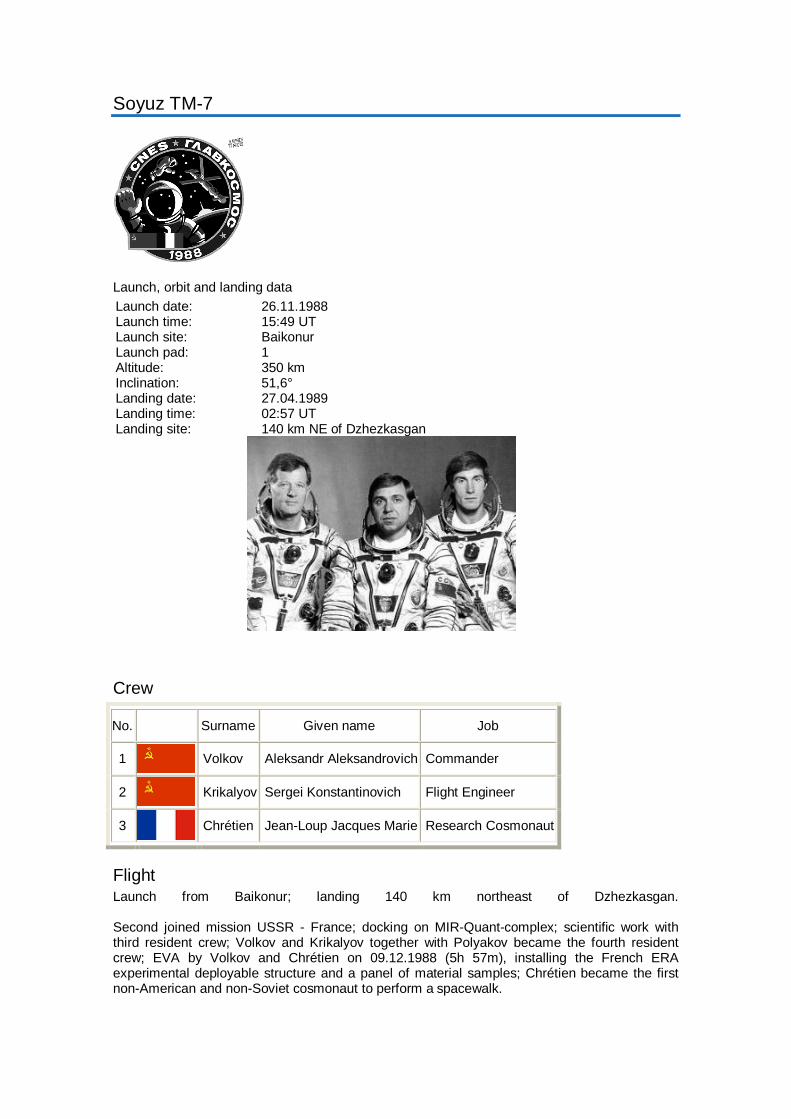
Soyuz TM-7
Launch, orbit and landing data Launch date: 26.11.1988 Launch time: 15:49 UT Launch site: Baikonur Launch pad: 1 Altitude: 350 km Inclination: 51,6° Landing date: 27.04.1989 Landing time: 02:57 UT Landing site: 140 km NE of Dzhezkasgan
Crew
No. Surname Given name Job
1 Volkov Aleksandr Aleksandrovich Commander
2 Krikalyov Sergei Konstantinovich Flight Engineer
3 Chrétien Jean-Loup Jacques Marie Research Cosmonaut
Flight Launch from Baikonur; landing 140 km northeast of Dzhezkasgan. Second joined mission USSR - France; docking on MIR-Quant-complex; scientific work with third resident crew; Volkov and Krikalyov together with Polyakov became the fourth resident crew; EVA by Volkov and Chrétien on 09.12.1988 (5h 57m), installing the French ERA experimental deployable structure and a panel of material samples; Chrétien became the first non-American and non-Soviet cosmonaut to perform a spacewalk.

Photos / Drawings
NASA - NSSDC - Spacecraft - Details
http://nssdc.gsfc.nasa.gov/nmc/spacecraftDisplay.do?id=1988-018A[19/02/2011 23:21:13]
Sunday, 20 February 2011
Description
Spacenet 3-R was launched from Kourou, French Guiana, onan Ariane 3 launch vehicle, for the United States.
Spacenet 3
NSSDC ID: 1988-018A
Alternate Names
Geostar R01
18951
Facts in Brief
Launch Date: 1988-03-11Launch Vehicle: Ariane3Launch Site: Kourou,French GuianaMass: 1216.8 kg
Funding Agency
GE AmericanCommunications, Inc.(United States)
Discipline
Communications
AdditionalInformation
Launch/Orbitalinformation for Spacenet3
Experiments on Spacenet3
Data collections fromSpacenet 3
Questions or commentsabout this spacecraft canbe directed to: CoordinatedRequest and User SupportOffice.
NSSDC MasterCatalog Search
Spacecraft
Experiments
Data Collections
Personnel
Publications
Maps
New/Updated Data
Lunar/Planetary Events
+ Privacy Policy and Important Notices NASA Official: Dr. Ed GrayzeckCurator: E. Bell, IIVersion 4.0.14, 08 October 2010
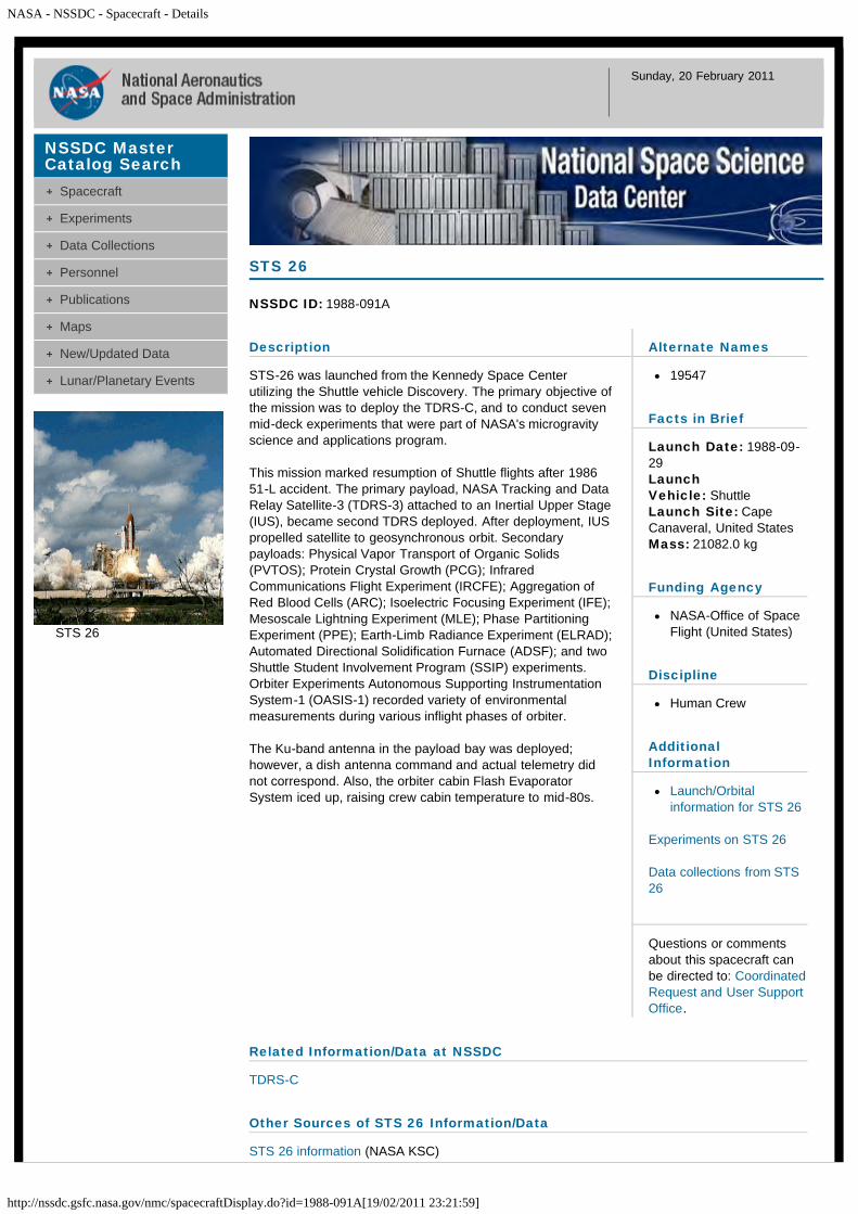
NASA - NSSDC - Spacecraft - Details
http://nssdc.gsfc.nasa.gov/nmc/spacecraftDisplay.do?id=1988-091A[19/02/2011 23:21:59]
Sunday, 20 February 2011
Description
STS-26 was launched from the Kennedy Space Centerutilizing the Shuttle vehicle Discovery. The primary objective ofthe mission was to deploy the TDRS-C, and to conduct sevenmid-deck experiments that were part of NASA's microgravityscience and applications program.
This mission marked resumption of Shuttle flights after 198651-L accident. The primary payload, NASA Tracking and DataRelay Satellite-3 (TDRS-3) attached to an Inertial Upper Stage(IUS), became second TDRS deployed. After deployment, IUSpropelled satellite to geosynchronous orbit. Secondarypayloads: Physical Vapor Transport of Organic Solids(PVTOS); Protein Crystal Growth (PCG); InfraredCommunications Flight Experiment (IRCFE); Aggregation ofRed Blood Cells (ARC); Isoelectric Focusing Experiment (IFE);Mesoscale Lightning Experiment (MLE); Phase PartitioningExperiment (PPE); Earth-Limb Radiance Experiment (ELRAD);Automated Directional Solidification Furnace (ADSF); and twoShuttle Student Involvement Program (SSIP) experiments.Orbiter Experiments Autonomous Supporting InstrumentationSystem-1 (OASIS-1) recorded variety of environmentalmeasurements during various inflight phases of orbiter.
The Ku-band antenna in the payload bay was deployed;however, a dish antenna command and actual telemetry didnot correspond. Also, the orbiter cabin Flash EvaporatorSystem iced up, raising crew cabin temperature to mid-80s.
STS 26
NSSDC ID: 1988-091A
Alternate Names
19547
Facts in Brief
Launch Date: 1988-09-29LaunchVehicle: ShuttleLaunch Site: CapeCanaveral, United StatesMass: 21082.0 kg
Funding Agency
NASA-Office of SpaceFlight (United States)
Discipline
Human Crew
AdditionalInformation
Launch/Orbitalinformation for STS 26
Experiments on STS 26
Data collections from STS26
Questions or commentsabout this spacecraft canbe directed to: CoordinatedRequest and User SupportOffice.
Related Information/Data at NSSDC
TDRS-C
Other Sources of STS 26 Information/Data
STS 26 information (NASA KSC)
NSSDC MasterCatalog Search
Spacecraft
Experiments
Data Collections
Personnel
Publications
Maps
New/Updated Data
Lunar/Planetary Events
STS 26
NASA - NSSDC - Spacecraft - Details
http://nssdc.gsfc.nasa.gov/nmc/spacecraftDisplay.do?id=1988-091A[19/02/2011 23:21:59]
STS 26 Press Release images (NASA JSC)
+ Privacy Policy and Important Notices NASA Official: Dr. Ed GrayzeckCurator: E. Bell, IIVersion 4.0.14, 08 October 2010
NASA - NSSDC - Spacecraft - Details
http://nssdc.gsfc.nasa.gov/nmc/spacecraftDisplay.do?id=1988-106A[19/02/2011 23:22:33]
Sunday, 20 February 2011
Description
STS-27 (Space Transportation System-27) was launched fromthe Kennedy Space Center utilizing the Shuttle vehicle Atlantis.It carried a five-member All were military personnel, and threewere veterans of previous Shuttle flights. STS-27 MissionCommander Robert L. Gibson (Cdr., USN) was pilot on STS41-B in February 1984 and commander on 61-C in January1986. Mission Specialists Richard M. Mullane (Col., USAF)and Jerry L. Ross (Lt. Col., USAF) flew on 41-D in August1984 and 61-B in November 1985, respectively. STS-27 willbe the first space flight for Pilot Guy S. Gardner (Lt. Col.,USAF) and Mission Specialist William M. Shepherd (Cdr.,USN).
STS 27
NSSDC ID: 1988-106A
Alternate Names
19670
Facts in Brief
Launch Date: 1988-12-02LaunchVehicle: ShuttleLaunch Site: CapeCanaveral, United States
Funding Agencies
Department of Defense(United States)
NASA-Office of SpaceFlight (United States)
Discipline
Human Crew
AdditionalInformation
Launch/Orbitalinformation for STS 27
Experiments on STS 27
Data collections from STS27
Questions or commentsabout this spacecraft canbe directed to: Dr. H. KentHills.
NSSDC MasterCatalog Search
Spacecraft
Experiments
Data Collections
Personnel
Publications
Maps
New/Updated Data
Lunar/Planetary Events
+ Privacy Policy and Important Notices NASA Official: Dr. Ed GrayzeckCurator: E. Bell, IIVersion 4.0.14, 08 October 2010
NASA - NSSDC - Spacecraft - Details
http://nssdc.gsfc.nasa.gov/nmc/spacecraftDisplay.do?id=1988-098A[19/02/2011 23:23:01]
Sunday, 20 February 2011
Description
TDF 1, a French telecommunications satellite, was launchedfrom Kourou, French Guiana.
TDF 1
NSSDC ID: 1988-098A
Alternate Names
19621
Facts in Brief
Launch Date: 1988-10-28Launch Vehicle: Ariane2Launch Site: Kourou,French GuianaMass: 2076.7 kg
Funding Agency
EuropeanTelecommunicationsSatellite Consortium(France)
Discipline
Communications
AdditionalInformation
Launch/Orbitalinformation for TDF 1
Experiments on TDF 1
Data collections from TDF1
Questions or commentsabout this spacecraft canbe directed to: CoordinatedRequest and User SupportOffice.
NSSDC MasterCatalog Search
Spacecraft
Experiments
Data Collections
Personnel
Publications
Maps
New/Updated Data
Lunar/Planetary Events
+ Privacy Policy and Important Notices NASA Official: Dr. Ed GrayzeckCurator: E. Bell, IIVersion 4.0.14, 08 October 2010
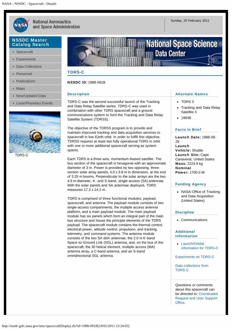
NASA - NSSDC - Spacecraft - Details
http://nssdc.gsfc.nasa.gov/nmc/spacecraftDisplay.do?id=1988-091B[19/02/2011 23:24:05]
Sunday, 20 February 2011
Description
TDRS-C was the second successful launch of the Trackingand Data Relay Satellite series. TDRS-C was used incombination with other TDRS spacecraft and a groundcommunications system to form the Tracking and Data RelaySatellite System (TDRSS).
The objective of the TDRSS program is to provide andmaintain improved tracking and data acquisition services tospacecraft in low-Earth orbit. In order to fulfill this objective,TDRSS requires at least two fully operational TDRS in orbitwith one or more additional spacecraft serving as systemspares.
Each TDRS is a three-axis, momentum-biased satellite. Thebus section of the spacecraft is hexagonal with an approximatediameter of 3 m. Power is provided by two opposing, three-section solar array panels, 4.0 x 3.8 m in dimension, at the endof 3.25 m booms. Perpendicular to the solar arrays are the two4.9 m diameter, K- and S-band, single-access (SA) antennae.With the solar panels and SA antennae deployed, TDRSmeasures 17.3 x 14.2 m.
TDRS is comprised of three functional modules: payload,spacecraft, and antenna. The payload module consists of twosingle-access compartments, the multiple access antennaplatform, and a main payload module. The main payloadmodule has six panels which form an integral part of the mainbus structure and house the principle elements of the TDRSpayload. The spacecraft module contains the thermal control,electrical power, attitude control, propulsion, and tracking,telemetry, and command systems. The antenna moduleconsists of the two SA dish antennae, the 2.0 m K-bandSpace-to-Ground Link (SGL) antenna, and, on the bus of thespacecraft, the 30 helical element, multiple access (MA)antenna array, a C-band antenna, and an S-bandomnidirectional SGL antenna.
TDRS-C
NSSDC ID: 1988-091B
Alternate Names
TDRS 3
Tracking and Data RelaySatellite 3
19548
Facts in Brief
Launch Date: 1988-09-29LaunchVehicle: ShuttleLaunch Site: CapeCanaveral, United StatesMass: 2224.9 kgNominalPower: 1700.0 W
Funding Agency
NASA-Office of Trackingand Data Acquisition(United States)
Discipline
Communications
AdditionalInformation
Launch/Orbitalinformation for TDRS-C
Experiments on TDRS-C
Data collections fromTDRS-C
Questions or commentsabout this spacecraft canbe directed to: CoordinatedRequest and User SupportOffice.
NSSDC MasterCatalog Search
Spacecraft
Experiments
Data Collections
Personnel
Publications
Maps
New/Updated Data
Lunar/Planetary Events
TDRS-C
NASA - NSSDC - Spacecraft - Details
http://nssdc.gsfc.nasa.gov/nmc/spacecraftDisplay.do?id=1988-091B[19/02/2011 23:24:05]
Personnel
Name Role Original Affiliation E-mail
Mr. George Q. Clark Project Manager NASA Goddard Space Flight Center
Related Information/Data at NSSDC
NSSDC TDRS pageSTS 26
Other Sources of TDRS Information/Data
TDRS program
+ Privacy Policy and Important Notices NASA Official: Dr. Ed GrayzeckCurator: E. Bell, IIVersion 4.0.14, 08 October 2010
NASA - NSSDC - Spacecraft - Details
http://nssdc.gsfc.nasa.gov/nmc/spacecraftDisplay.do?id=1988-018B[19/02/2011 23:25:04]
Sunday, 20 February 2011
Description
Telecom-1C was launched from Kourou, French Guiana on anAriane 3 launch vehicle, for France.
TELECOM 1C
NSSDC ID: 1988-018B
Alternate Names
18952
Facts in Brief
Launch Date: 1988-03-11Launch Vehicle: Ariane3Launch Site: Kourou,French GuianaMass: 690.0 kg
Funding Agency
France Telecom (France)
Discipline
Communications
AdditionalInformation
Launch/Orbitalinformation for TELECOM1C
Experiments on TELECOM1C
Data collections fromTELECOM 1C
Questions or commentsabout this spacecraft canbe directed to: CoordinatedRequest and User SupportOffice.
NSSDC MasterCatalog Search
Spacecraft
Experiments
Data Collections
Personnel
Publications
Maps
New/Updated Data
Lunar/Planetary Events
+ Privacy Policy and Important Notices NASA Official: Dr. Ed GrayzeckCurator: E. Bell, IIVersion 4.0.14, 08 October 2010
NASA - NSSDC - Spacecraft - Details
http://nssdc.gsfc.nasa.gov/nmc/spacecraftDisplay.do?id=1988-033A[19/02/2011 23:25:41]
Sunday, 20 February 2011
Description
Transit-O 23 was a US Navy navigation satellite launched by aScout G rocket. Transit, one of the first operational satellitesystems, was also know as the Navy Navigation Satellite(NNS).
The Transit spacecraft were developed for updating the inertialnavigation systems on board US Navy Polaris submarines, andlater for civilian use. Transit receivers used the knowncharacteristics of the satellite's orbit, measured the Dopplershift of the satellite's radio signal, and thereby calculated thereceivers position on the earth. As a single spacecraft travelledoverhead, the user measured the Doppler shift over a 15minute period by receiving timing marks and satellite orbitalinformation on two separate frequencies, 149.99 and 399.97MHz. These signals were corrected for ionospheric refractionand the information was then fed into the users navigationsystem.
Individual Transit satellites operated for over 10 years.Technical break- throughs during the program included gravitygradient stabilization, the use of radio-isotope thermoelecticgenerators (RTG), and navigation satellite technologies laterused in the GPS system. Transit was superseded by theNavstar global positioning system. The use of the satellites fornavigation was discontinued at the end of 1996 but thesatellites continued transmitting and became the NavyIonospheric Monitoring System (NIMS).
Transit-O 23
NSSDC ID: 1988-033A
Alternate Names
NNSS 30230
OSCAR(NAV) 23
19070
Facts in Brief
Launch Date: 1988-04-26Launch Vehicle: ScoutLaunchSite: Vandenberg AFB,United StatesMass: 64.0 kg
Funding Agency
Department of Defense-Department of the Navy(United States)
Discipline
Navigation & GlobalPositioning
AdditionalInformation
Launch/Orbitalinformation for Transit-O23
Experiments on Transit-O23
Data collections fromTransit-O 23
Questions or commentsabout this spacecraft canbe directed to: CoordinatedRequest and User SupportOffice.
NSSDC MasterCatalog Search
Spacecraft
Experiments
Data Collections
Personnel
Publications
Maps
New/Updated Data
Lunar/Planetary Events
NASA - NSSDC - Spacecraft - Details
http://nssdc.gsfc.nasa.gov/nmc/spacecraftDisplay.do?id=1988-074A[19/02/2011 23:26:11]
Sunday, 20 February 2011
Description
Transit-O 25 was a US Navy navigation satellite launched by aScout G rocket. Transit, one of the first operational satellitesystems, was also know as the Navy Navigation Satellite(NNS).
The Transit spacecraft were developed for updating the inertialnavigation systems on board US Navy Polaris submarines, andlater for civilian use. Transit receivers used the knowncharacteristics of the satellite's orbit, measured the Dopplershift of the satellite's radio signal, and thereby calculated thereceivers position on the earth. As a single spacecraft travelledoverhead, the user measured the Doppler shift over a 15minute period by receiving timing marks and satellite orbitalinformation on two separate frequencies, 149.99 and 399.97MHz. These signals were corrected for ionospheric refractionand the information was then fed into the users navigationsystem.
Individual Transit satellites operated for over 10 years.Technical break- throughs during the program included gravitygradient stabilization, the use of radio-isotope thermoelecticgenerators (RTG), and navigation satellite technologies laterused in the GPS system. Transit was superseded by theNavstar global positioning system. The use of the satellites fornavigation was discontinued at the end of 1996 but thesatellites continued transmitting and became the NavyIonospheric Monitoring System (NIMS).
Transit-O 25
NSSDC ID: 1988-074A
Alternate Names
OSCAR(NAV) 25
19419
Facts in Brief
Launch Date: 1988-08-25Launch Vehicle: ScoutLaunchSite: Vandenberg AFB,United StatesMass: 59.0 kg
Funding Agency
Department of Defense-Department of the Navy(United States)
Discipline
Navigation & GlobalPositioning
AdditionalInformation
Launch/Orbitalinformation for Transit-O25
Experiments on Transit-O25
Data collections fromTransit-O 25
Questions or commentsabout this spacecraft canbe directed to: CoordinatedRequest and User SupportOffice.
NSSDC MasterCatalog Search
Spacecraft
Experiments
Data Collections
Personnel
Publications
Maps
New/Updated Data
Lunar/Planetary Events
+ Privacy Policy and Important Notices NASA Official: Dr. Ed GrayzeckCurator: E. Bell, II

NASA - NSSDC - Spacecraft - Details
http://nssdc.gsfc.nasa.gov/nmc/spacecraftDisplay.do?id=1988-074B[19/02/2011 23:26:53]
Sunday, 20 February 2011
Description
Transit-O 31 was a US Navy navigation satellite launched by aScout G rocket. Transit, one of the first operational satellitesystems, was also known as the Navy Navigation Satellite(NNS).
The Transit spacecraft were developed for updating the inertialnavigation systems on board US Navy Polaris submarines, andlater for civilian use. Transit receivers used the knowncharacteristics of the satellite's orbit, measured the Dopplershift of the satellite's radio signal, and thereby calculated thereceivers position on the earth. As a single spacecraft travelledoverhead, the user measured the Doppler shift over a 15minute period by receiving timing marks and satellite orbitalinformation on two separate frequencies, 149.99 and 399.97MHz. These signals were corrected for ionospheric refractionand the information was then fed into the users navigationsystem.
Individual Transit satellites operated for over 10 years.Technical break- throughs during the program included gravitygradient stabilization, the use of radio-isotope thermoelecticgenerators (RTG), and navigation satellite technologies laterused in the GPS system. Transit was superseded by theNavstar global positioning system. The use of the satellites fornavigation was discontinued at the end of 1996 but thesatellites continued transmitting and became the NavyIonospheric Monitoring System (NIMS).
Transit-O 31
NSSDC ID: 1988-074B
Alternate Names
NNSS 30310
OSCAR(NAV) 31
19420
Facts in Brief
Launch Date: 1988-08-25Launch Vehicle: ScoutLaunchSite: Vandenberg AFB,United StatesMass: 59.0 kg
Funding Agency
Department of Defense-Department of the Navy(United States)
Discipline
Navigation & GlobalPositioning
AdditionalInformation
Launch/Orbitalinformation for Transit-O31
Experiments on Transit-O31
Data collections fromTransit-O 31
Questions or commentsabout this spacecraft canbe directed to: CoordinatedRequest and User SupportOffice.
NSSDC MasterCatalog Search
Spacecraft
Experiments
Data Collections
Personnel
Publications
Maps
New/Updated Data
Lunar/Planetary Events

NASA - NSSDC - Spacecraft - Details
http://nssdc.gsfc.nasa.gov/nmc/spacecraftDisplay.do?id=1988-074B[19/02/2011 23:26:53]
+ Privacy Policy and Important Notices NASA Official: Dr. Ed GrayzeckCurator: E. Bell, IIVersion 4.0.14, 08 October 2010

NASA - NSSDC - Spacecraft - Details
http://nssdc.gsfc.nasa.gov/nmc/spacecraftDisplay.do?id=1988-033B[19/02/2011 23:27:46]
Sunday, 20 February 2011
Description
Transit-O 32 was a US Navy navigation satellite launched by aScout G rocket. Transit, one of the first operational satellitesystems, was also known as the Navy Navigation Satellite(NNS).
The Transit spacecraft were developed for updating the inertialnavigation systems on board US Navy Polaris submarines, andlater for civilian use. Transit receivers used the knowncharacteristics of the satellite's orbit, measured the Dopplershift of the satellite's radio signal, and thereby calculated thereceivers position on the earth. As a single spacecraft travelledoverhead, the user measured the Doppler shift over a 15minute period by receiving timing marks and satellite orbitalinformation on two separate frequencies, 149.99 and 399.97MHz. These signals were corrected for ionospheric refractionand the information was then fed into the users navigationsystem.
Individual Transit satellites operated for over 10 years.Technical break- throughs during the program included gravitygradient stabilization, the use of radio-isotope thermoelecticgenerators (RTG), and navigation satellite technologies laterused in the GPS system. Transit was superseded by theNavstar global positioning system. The use of the satellites fornavigation was discontinued at the end of 1996 but thesatellites continued transmitting and became the NavyIonospheric Monitoring System (NIMS).
Transit-O 32
NSSDC ID: 1988-033B
Alternate Names
OSCAR(NAV) 32
NNSS 30320
19071
Facts in Brief
Launch Date: 1988-04-26Launch Vehicle: ScoutLaunchSite: Vandenberg AFB,United StatesMass: 64.0 kg
Funding Agency
Department of Defense-Department of the Navy(United States)
Discipline
Navigation & GlobalPositioning
AdditionalInformation
Launch/Orbitalinformation for Transit-O32
Experiments on Transit-O32
Data collections fromTransit-O 32
Questions or commentsabout this spacecraft canbe directed to: CoordinatedRequest and User SupportOffice.
NSSDC MasterCatalog Search
Spacecraft
Experiments
Data Collections
Personnel
Publications
Maps
New/Updated Data
Lunar/Planetary Events
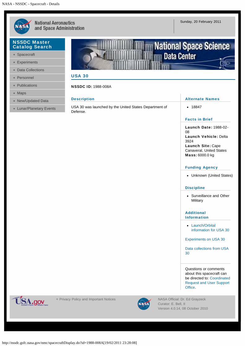
NASA - NSSDC - Spacecraft - Details
http://nssdc.gsfc.nasa.gov/nmc/spacecraftDisplay.do?id=1988-008A[19/02/2011 23:28:08]
Sunday, 20 February 2011
Description
USA 30 was launched by the United States Department ofDefense.
USA 30
NSSDC ID: 1988-008A
Alternate Names
18847
Facts in Brief
Launch Date: 1988-02-08Launch Vehicle: Delta3924Launch Site: CapeCanaveral, United StatesMass: 6000.0 kg
Funding Agency
Unknown (United States)
Discipline
Surveillance and OtherMilitary
AdditionalInformation
Launch/Orbitalinformation for USA 30
Experiments on USA 30
Data collections from USA30
Questions or commentsabout this spacecraft canbe directed to: CoordinatedRequest and User SupportOffice.
NSSDC MasterCatalog Search
Spacecraft
Experiments
Data Collections
Personnel
Publications
Maps
New/Updated Data
Lunar/Planetary Events
+ Privacy Policy and Important Notices NASA Official: Dr. Ed GrayzeckCurator: E. Bell, IIVersion 4.0.14, 08 October 2010
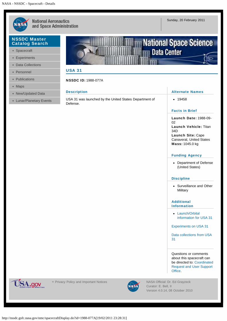
NASA - NSSDC - Spacecraft - Details
http://nssdc.gsfc.nasa.gov/nmc/spacecraftDisplay.do?id=1988-077A[19/02/2011 23:28:31]
Sunday, 20 February 2011
Description
USA 31 was launched by the United States Department ofDefense.
USA 31
NSSDC ID: 1988-077A
Alternate Names
19458
Facts in Brief
Launch Date: 1988-09-02Launch Vehicle: Titan34DLaunch Site: CapeCanaveral, United StatesMass: 1045.0 kg
Funding Agency
Department of Defense(United States)
Discipline
Surveillance and OtherMilitary
AdditionalInformation
Launch/Orbitalinformation for USA 31
Experiments on USA 31
Data collections from USA31
Questions or commentsabout this spacecraft canbe directed to: CoordinatedRequest and User SupportOffice.
NSSDC MasterCatalog Search
Spacecraft
Experiments
Data Collections
Personnel
Publications
Maps
New/Updated Data
Lunar/Planetary Events
+ Privacy Policy and Important Notices NASA Official: Dr. Ed GrayzeckCurator: E. Bell, IIVersion 4.0.14, 08 October 2010
![lanzamientos.files.wordpress.com · NASA - NSSDC - Spacecraft - Query Results 03/11/2010 0:05:38] Wednesday, 03 November 2010. Spacecraft](https://img.pdfslide.us/doc/110x75/5b1672207f8b9a4f6d8c00a5/-nasa-nssdc-spacecraft-query-results-03112010-00538-wednesday-03.jpg)
![lanzamientos.files.wordpress.comNASA - NSSDC - Spacecraft - Query Results 14/08/2010 23:19:08] Saturday, 14 August 2010. …](https://img.pdfslide.us/doc/110x75/5ecf904a61da2f5cd579cf65/nasa-nssdc-spacecraft-query-results-14082010-231908-saturday-14-august.jpg)