Embed Size (px)
Citation preview
44 InsideGNSS N O V E M B E R / D E C E M B E R 2 0 1 6 www.insidegnss.com
Spacecraft in low Earth orbit (LEO), at altitudes below 3,000 kilometers, remain within the main Global
Positioning System (GPS) signals’ Earth coverage. Spacecraft employing GPS at these altitudes enjoy signal availability and navigation and timing performance emulating that of terrestrial users.
Until recently, the use of GPS on spacecraft that traverse above LEO and beyond the orbit of the GPS constel-lations was unproven and considered risky by spacecraft managers. The big question at the time was: would the power levels, availability, and accuracy of GPS signals at these altitudes facili-tate navigation solutions and enhance mission objectives?
Flight experiments conducted around the turn of the new millennium demonstrated the viability of using GPS for navigation and time sensing in these high orbits by exploiting the full (aggre-gate) signal. In other words, employing the residual side-lobe signals in addition to the higher power, narrow, main Earth coverage signal.
Through a concerted effort by NASA, private industry, and others, specially designed weak signal GPS receivers were developed to support space missions at these high altitudes. New, exciting mis-sions were proposed to make use of these navigation signals in space. Today, oper-ational space missions are employing
GPS above LEO and many other mis-sions are in development.
Spacecraft using GPS in these orbits support a myriad of applications that pro-tect Earth’s inhabitants, through Earth and space weather detection and predic-tion, and revolutionize space missions through space vehicle formation flying, as examples. The emergence of modern-ized and new Global Navigation Satellite Systems (GNSS) affords spacecraft project managers a richer, more robust naviga-tion sensing capability as the use of GPS signals combined with those from other GNSS constellations to support position-ing and navigation applications above the orbits of GNSS satellites.
The expansion of the number of GNSS constellations, such as the Europe-an Union’s Galileo, and China’s BeiDou, and upgrades of existing constellations — GPS and Russia’s GLONASS system — are enabling much more robust navi-gation solutions. This is accomplished through the substantial increase in the number of available signals, improved signal diversity, which improves navi-gation resiliency, and improved signal geometry, all of which enable improved end-user navigation performance.
Space user enhancements, made possible with interoperable GNSS sig-nals, require key performance param-eters specified across the constella-tions. The constellation providers and
The emergence of modernized and new GNSS systems has made possible the use of GPS signals combined with those from other constellations to support positioning and navigation applications above the orbits of GNSS satellites.
NA
SA
Navigating in SpaceTaking GNSS to New Heights
JAMES J. MILLERNATIONAL AERONAUTICS AND SPACE ADMINISTRATION (NASA)
FRANK H. BAUERFBAUER AEROSPACE CONSULTING SERVICES
JENNIFER E. DONALDSONNASA, GODDARD SPACE FLIGHT CENTER
A.J. ORIAOVERLOOK SYSTEMS TECHNOLOGIES, INC.
SCOTT PACEGEORGE WASHINGTON UNIVERSITY
JOEL J. K. PARKERNASA, GODDARD SPACE FLIGHT CENTER
BRYAN WELCHNASA, GLENN RESEARCH CENTER
Navigating in SpaceTaking GNSS to New Heights

www.insidegnss.com N O V E M B E R / D E C E M B E R 2 0 1 6 InsideGNSS 45
such regional augmentation systems as Japan’s Quasi Zenith Satellite System (QZSS) and India’s NavIC (Naviga-tion Indian Constellation), are work-ing diligently to achieve space user interoperability through forums such as the United Nations (UN)-sponsored International Committee on GNSS (ICG). These initiatives will result in improved capabilities for on-board autonomous positioning, navigation, and timing (PNT) at high altitude and better resilience to potential disrup-tions to the signals broadcast by any individual GNSS constellation.
GPS Use in HEO/GEOGPS consists of a core volume of sat-ellites in medium Earth orbit (MEO) transmitting one-way radio signals that are used to calculate three-dimensional position in the terrestrial and near-Earth domain, plus time. To achieve this, at least four GPS satellites are needed to be within line-of-sight at any given time to enable on-board real-time autonomous navigation through the formation of a point solution.
Continuous availability of at least four signals has become a standard expectation for GPS users up to 3,000 kilometers altitude, a region of space also known as the GPS Terrestrial Ser-vice Volume (TSV). However, as we
move up in altitude beyond 3,000 kilo-meters, the number of available GPS signals decreases and, because of poor geometry and blockage of main beam reception by the Earth, four GPS signals are rarely available to enable formation of a point solution. Modern on-board navigation filters can operate with as little as one signal available at any one time, but the solution is not as accurate and even this level of availability can become less than continuous.
At these higher altitudes, the “spill-over” energy radiating over the limb of the Earth has come to define the utility and access of GPS (Figure 1). This more chal-lenging signal processing environment has been designated as the GPS Space Ser-vice Volume (SSV), defined as the region of space between 3,000 kilometers altitude and geosynchronous orbit (GEO) altitude of about 36,000 kilometers (Figure 2).
Since 2004, NASA has been work-ing with the U.S. Air Force to charac-terize and specify the performance of GPS within the SSV, which is currently defined in terms of user range error, minimum received power, and mini-mum signal availability of the Earth coverage GPS signals. For the L1 fre-quency, at GEO altitude the GPS SSV specification for a minimal 27-satellite-vehicle (SV) constellation calls for ≥ 1 signal(s) to be visible 80 percent of the
time, and ≥ 4 visible one percent of the time, which is consistent with the per-formance provided by the traditional “spill-over” Earth coverage signal only. However, more advanced analyses and actual on-orbit mission measurements are now demonstrating that, in prac-tice, the true capability of services in the space domain is much greater when using the full aggregate GPS signal. In fact, missions at and beyond GEO have tracked more than four GPS aggregate signals 100 percent of the time.
The Promise and Benefits of GNSS to High Altitude Space UsersBased on current demonstrated per-formance of GPS in space, many future high Earth orbit (HEO) missions are poised to benefit from improved navi-gation, timing, and on-board auton-omy. Figure 3 summarizes space mis-sion applications enabled by precision GNSS navigation in HEO. These include remote sensing from GEO requiring pre-cise geolocation (e.g., Earth and space weather operational satellite constella-tions), space science missions, highly maneuverable spacecraft that need real-time orbit knowledge during maneuvers, formation flying missions, and others.
Like their LEO cousins, missions in the SSV segment benefit from cur-rent GNSS capabilities, including fast
FIGURE 2 GPS Terrestrial Service Volume and Space Service Volume coverage
Space Service Volume
(Medium Altitudes)3,000 to 8,000 km
Terrestrial ServiceVolume
Surface to 3,000 km
Space Service Volume(High/Geosynchronous Altitudes)
8,000 to 36,000 km
FIGURE 1 GNSS visibility limitations at higher altitude

46 InsideGNSS N O V E M B E R / D E C E M B E R 2 0 1 6 www.insidegnss.com
recovery from trajectory maneuvers, improved operations cadence, increased satellite autonomy, improved navigation performance, and precise timing reduc-ing the need for expensive on-board clocks. These capabilities enhance mis-sion data return and enable many ben-efits to society.
A case example of the societal ben-efits is the joint NASA/National Oce-anic and Atmospheric Administration (NOAA) Geostationary Operational Environmental Satellite (GOES) mission set. GOES is used by the National Weath-er Service (NWS) and others to enable weather predictions, severe storm warn-ings, and public safety information that saves lives and protects property. The next generation spacecraft series, GOES-R (GOES-R, S, T & U), which plans to be operational from 2016 to 2035, will employ GPS to substantially improve navigation as compared to previous generations. GOES-R’s two key inno-vations—an improved imaging instru-ment coupled with GPS PNT — provide game-changing science products to sub-stantially improved weather prediction capabilities and public-safety situational awareness of fast-moving events.
GOES-R illustrates the class of appli-cations in which navigation perfor-mance must be maintained during, and subsequent to, propulsive maneuvers. On the legacy GOES satellites without
GPS, station-keeping maneuvers man-dated relaxing requirements for up to six hours post-maneuver, directly affecting the geolocation accuracy for tracking time-critical events such as tornadoes, flash floods, and forest fires.
By effectively tracking the aggregate GPS signals already radiating over the Earth’s limb, signal availability is vastly improved, leading directly to precise rapid recovery from station-keeping maneuvers and accelerated data col-lection and processing during poten-tial disaster scenarios. The GPS SSV is enabling substantial improvements in GOES weather products that enhance weather prediction and provide timely natural disaster warnings to people locat-ed in the Western hemisphere including:• improvedcloud-trackedwindmea-
surements to increase warning times for those in severe storm danger zones
• exactlocationandvolumeofdown-pours in mountainous areas to sup-port accurate, timely f lash f lood warnings
• timely,preciselocationofremotewild fires to enable safe placement of firefighters and equipment near fire outbreaks
• moreaccuratepredictionofearlymorning fog for aviation operations
• abilitytobetterobserveandpre-dict weather in mountainous areas, where weather radar is ineffective
• high imager tempo and spatial/spectral improvements that enable reliable blending of GEO-observed (high temporal resolution) with LEO-observed (high spatial resolu-tion) meteorology as well as blending with ground-based radars.Without sufficient GPS signal avail-
ability in the SSV, such improved prod-ucts would simply not be available. GOES data users include everyone in the Western Hemisphere as they are directly impacted by weather and natural cata-strophic events. Societal benefits derived from GOES-R, as enabled by GPS, will include lives saved, property protected, and aircraft optimally routed. Scientists expect that reliable extended forecasting will stretch from three to five days now to five to seven days with GOES-R data, enabled by the nearly-continuous avail-ability of GPS at GEO.
Another example of the capabilities that the GPS provides to space users in HEO is NASA’s Magnetospheric Multi-Scale (MMS) mission. MMS, launched in March 2015, is a formation flyer con-sisting of four GPS-equipped spacecraft operating in a highly eccentric orbit to measure the properties and effects of space weather. MMS’s Navigator GPS receiver has enabled onboard (autono-mous) navigation well beyond GPS alti-tude, and its measurements have greatly improved our understanding of GPS
performance in the HEO envi-ronment well beyond GEO. MMS effortlessly tracks 8 to 12 GPS signals in an orbit with an apogee at 70,000 kilometers, or approximately double the altitude of GEO, the formal boundary of SSV coverage. Thus, MMS has demonstrated GPS satellites’ full capacity to support space users.
Flight data shows that the signal availability provided by a minimal 27–space vehicle GPS constellation while using the full aggregate signal is 100 percent for ≥ 1 signal(s), and 98 percent for ≥ 4 signals as report-ed in the presentation by F. H. Bauer, “GNSS Space Service Volume and Space User Data
NAVIGATING IN SPACE
FIGURE 3 Current and future mission types in high Earth orbit benefiting from real-time GNSS navigation
Earth Weather Predictionusing Advanced Weather Satellites
Space WeatherObservations
Precise RelativePositioning
Launch Vehicle UpperStages and Beyond -
GEO applications
Formation Flying,Space Situational Awareness,
Proximity Operations
Precise Position Knowledge and Control at GEO
www.insidegnss.com N O V E M B E R / D E C E M B E R 2 0 1 6 InsideGNSS 47
Update” at the 15th meeting of the GNSS Provider’s Forum during the 10th meeting of the ICG (ICG-10) in November 2015. (See Addition Resources section near the end of this article for a full citation.)
Additional data and analyses of the GPS SSV, comparing predicted and mea-sured performance, are described in other papers listed in the Additional Resources section as well. NASA has proposed an update to the GPS SSV specification to capture the needs of the emerging GPS SSV user base and to more accurately reflect the signal capabilities provided to high-altitude space users.
Other space missions in HEO/GEO that benefit from GPS/GNSS services range from science to space operations: space weather and heliospheric science, solar occultation, astrophysics, launch vehicle upper stages and interplanetary departure/return, space situational awareness, satellite servicing; formation flying, and optimizing GEO belt spacing for commercial spacecraft, i.e., higher precision station keeping that translates into enabling more spacecraft platforms to operate within the GEO belt. Thus, GPS truly becomes the cornerstone of an advanced space enterprise that is affordable and accessible to all, of great importance to the emerging commercial space sector in the United States.
Interoperable GNSS SSV through Multilateral Engagement at the ICGThe ICG is a UN forum, established in 2005, that meets annually to allow stake-holder organizations to coordinate on GNSS infrastructure and services. ICG benefits people worldwide by promoting the use of GNSS, particularly in devel-oping countries, by encouraging com-patibility and interoperability amongst global and regional service providers.
The ICG consists of a Providers Forum and plenary supported by four working groups (WGs), namely: Glob-al and Regional Navigation Satellite Systems, Signals and Services (WG-S, formerly WG-A for Radio Frequency Compatibility and Interoperability); Enhancement of Performance of GNSS Services (WG-B); Information Dissemi-nation and Capacity Building (WG-C); and Reference Frames, Timing and
Applications (WG-D). Most of the tech-nical work to develop an interoperable Multi-GNSS Space Service Volume is done within ICG WG-B, which is then adopted by all attendees through ICG Plenary Joint Statements at the end of their work sessions. Work is conducted throughout the year in preparation for the annual meetings, usually held in November or December. (See ICG web-site, <http://www.unoosa.org/oosa/en/ourwork/icg/icg.html>.)
Four GNSS constellations are in operation or under deployment, along with a number of regional augmen-tations and regional navigation sys-tems, some of which, such as QZSS and NavIC, also broadcast one-way ranging signals. As a result, a prop-erly equipped user can access the sig-nals from a combination of GNSS and regional constellations simultaneously to obtain improved performance and resiliency through enhanced signal availability, diversity, and geometry. The availability of this improved access is especially important at the higher altitudes of space missions due to the constraints noted earlier. However, this multi-constellation access requires con-stant coordination as the various sys-tems come online and are modernized, specifically: (1) interoperability among GNSS constellations, and (2) common definitions/specifications for use of GNSS signals within the SSV.
Once these core assumptions and requirements are agreed to and met by
the PNT service providers, users will be able to optimize their spacecraft systems based on mission needs to enable contin-uous, real-time, on-board autonomous navigation for operations at the more challenging GEO/HEO altitudes. This is turn will lower mission operation costs, improve vehicle navigation performance, and allow for quick mission recovery after spacecraft trajectory maneuvers.
With these operational benefits in mind, in 2012 NASA introduced the SSV concept to the ICG, where it was adopted and has matured to a point in 2016 that all global and regional PNT service pro-viders are in the process of characteriz-ing the SSV performance of their own respective GNSS constellations in con-sultation with the world’s space agencies. Several papers listed in the Additional Resources section address these efforts.
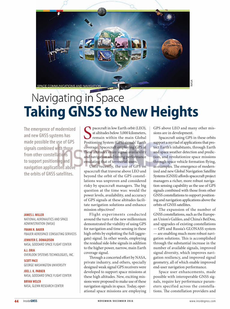
More recent contributions from NASA, and other space agencies within ICG WG-B, include conducting an inde-pendent assessment of the SSV using a multi-GNSS solution and developing GNSS flight experiments to validate sig-nal performance. The independent assess-ment consists of three phases with increas-ing complexity and fidelity (Figure 4).
Phase 1 of the assessment is a geo-metrical analysis of GNSS signal visibil-ity at GEO altitude and was completed in May 2016. Phase 2 augments the Phase 1 geometrical accesses by constraining the solution via various minimum radio frequency (RF) signal level thresholds, and was completed in September 2016.
FIGURE 4 ICG WG-B assessment of Space Service Volume
Phase 3: Speci�c User Missions
Phase 2: Signal StrengthAccess
Phase 1: Geometrical Access
GNSS Transmitter
Beam
GNSS Transmitter
Beam
GNSS Transmitter
Beam
Medium EarthOrbit User
GeostationaryOrbit User
Signal StrengthPoints in View
Signal StrengthPoints in View
GeometricalPoints in View
GeostationaryTransfer Orbit
Highly EllipticalOrbit Satellite
ReceiverPatternSSV Grid
(36000 kmAltitude)
SSV Grid(36000 kmAltitude)
SSV ReceiverPattern
SSV GridBeam

48 InsideGNSS N O V E M B E R / D E C E M B E R 2 0 1 6 www.insidegnss.com
NAVIGATING IN SPACE
Finally, Phase 3, which is currently under way, extends this analysis to specific user missions including those in MEO, geo-stationary transfer orbits (GTO), and highly elliptical orbits. This assessment has demonstrated how the combination of the Earth coverage signal from multiple GNSS satellites can greatly improve navi-gation capabilities available to space users.
A preliminary geometric analysis using only mainbeam “spill-over” Earth coverage signals from each constellation shows that combining GPS and Galileo would enable an average of three satel-lites in view at GEO, with four satellites in view 30 percent of the time. By com-parison, using all constellations (GPS, Galileo, GLONASS, BeiDou, QZSS, and NavIC) would enable four satellites visible at GEO approximately 95 percent of the time using the signals in the L1 frequency band. Further details are described in the paper by J. J. Miller et alia (2016B) listed in Additional Resources.
Detailed results for Phases 1 and 2 are described in articles by B. Welch listed in Additional Resources. The last two of those references are now fully published, dated November 2016. For example, Figure 5 depicts the geomet-ric analysis for L5 signal availability at GEO for GPS only, and Figure 6 shows the results for all the GNSS constella-tions plus the QZSS and NavIC regional navigation systems.
The ICG has been key in the pursuit of a fully interoperable Multi-GNSS SSV, with discussions and recommendations encouraging other PNT service provid-ers such as GLONASS, Galileo, BeiDou, QZSS, and NavIC to characterize the performance of GNSS services provided
to space users and start developing for-mal specifications. The ICG held its 11th annual meeting in Sochi, Russia, during the week of November 7–11, 2016. In preparation for this technical discussion, NASA has brought the latest flight data and analyses for discussion.
A key lesson learned is that GPS is still the “Gold Standard” for space-based PNT and, as such, NASA is proud to work with the U.S. Air Force to continue improving its capabilities. Missions such as NASA’s MMS have set a world record for highest and fastest acquisition and tracking of the GPS signal thus far, and have set the stage for future enhancements. GPS capabili-ties in space have also set the goal high for other GNSS constellations seeking to provide similar services.
For space users, comparable avail-ability and performance improvements will indeed become available as an interoperable GNSS SSV is incremen-tally realized by the work of the ICG. The ICG is making great strides in the coordination of interoperable signals and specifications that enable space missions of the future to employ GNSS signals well beyond LEO, and all users will benefit.
ConclusionA wide variety of space missions and applications stand to benefit from real-time on-board autonomous precision navigation in HEO either using GPS alone, or in combination with other GNSS signals. The ICG has become the world-wide forum where these benefits and contributions come together into an evolving Multi-GNSS SSV.
In addition, recent operational mis-sions have demonstrated that actual
performance of GPS far exceeds the current SSV specifications, which were developed over a decade ago when our understanding of the true performance of GPS in space was limited. It is now evident that once again GPS far exceeds all expectations, and for this NASA and our partner space agencies are grateful to the U.S. Air Force for providing this key infrastructure element.
The capabilities provided by the GPS aggregate signal structure (both main beam and side lobes) already serves criti-cal public safety space missions such as the GOES-R satellite just launched, and even preserving a subset of these existing aggregate signal capabilities would be a vital enabler for the GPS of the future to operate as a stand-alone system to support critical U.S. missions even as new multi-GNSS service options become available.
Until then, comparable availability and performance improvements will be realized incrementally as an interoperable Multi-GNSS system becomes fully opera-tional through the work of the ICG. The ICG is making great strides in the coordi-nation of interoperable signals and spec-ifications that will enable all manner of space missions to employ GNSS signals well beyond LEO. NASA’s looks forward to working with our partners to make this scenario a reality, with GPS as the cornerstone of the advancing U.S. space enterprise.
Additional Resources[1] Bauer, F. “GNSS Space Service Volume and Space User Data Update,” 15th Meeting of the GNSS Pro-vider’s Forum. November 2015. Available online at <www.unoosa.org/pdf/icg/2015/icg10/03pf.pdf>
[2] Chang, X., and X. Mei, and H. Yang. “Space Service Volume Performance of BDS.” International Commit-
FIGURE 5 Geometric analysis showing L5 signal visibility at GEO of GPS-only
FIGURE 6 Geometric analysis showing L5 signal visibility at GEO of GPS, GLONASS, Galileo, BeiDou, NAVIC, and QZSS combined

www.insidegnss.com N O V E M B E R / D E C E M B E R 2 0 1 6 InsideGNSS 49
tee for GNSS 10th Meeting. Boulder, Colorado, USA, November 2015. Online at <www.unoosa.org/pdf/icg/2015/icg10/wg/wgb02.pdf>
[3] Chapel, J., and D. Stancliffe, T. Bevacqua, S. Win-kler, B. Clapp, T. Rood, D. Gaylor, D. Freesland, and A. Krimchansky, “Guidance, navigation, and con-trol performance for the GOES-R spacecraft,” CEAS Space Journal, Volume 7, No. 2, pp. 87–104, 2015
[4] International Committee on Global Navigation Satellite Systems (ICG), <http://www.unoosa.org/oosa/en/ourwork/icg/icg.html>[5] Kogure, S., and M.Kishimoto. “MICHIBIKI (QZS–1) and Space Service Volume”. International Committee for GNSS 7th Meeting, Beijing, China, November 2012. Available online at <www.unoosa.org/pdf/icg/2012/icg-7/wg/wgb2-3.pdf >
[5] Kosenco, V., and A. Grechkoseev, andM. Sanzha-rov. “GLONASS Space Service Volume”. International Committee for GNSS 9th Meeting. Prague, Czech Republic, November 2014. Available online at <www.unoosa.org/pdf/icg/2014/wg/wgb04.pdf>
[6] Miller, J. J., and F. Bauer, A.J. Oria, S. Pace, J. Parker, and B. Welch, “Development of a Global Positioning System (GPS) and Multi- Global Navigation Satel-lite Systems (GNSS) Space Service Volume (SSV) to Support Space Users,” 22nd Ka and Broadband Communications Conference and the 34th AIAA International Communications Satellite Systems Conference. Cleveland, Ohio, USA, October 17-20, 2016
[7] Parker, J., and J. Valdez, F. Bauer, M. Moreau, “Use and Protection of GPS Sidelobe Signals for Enhanced Navigation Performance in High Earth Orbit”, American Astronautical Society, AAS 16-72, February 2016
[8] Wallner, S., “Galileo’s Contribution to an Interop-erable GNSS SSV.” International Committee for GNSS 10th Meeting, Boulder, Colorado, USA, November 2015. Available online at<www.unoosa.org/pdf/icg/2015/icg10/wg/wgb03.pdf>
[9] Welch, B., “Geometrical-Based Navigation Sys-tem Performance Assessment in the Space Service Volume Using a Multiglobal Navigation Satellite System Methodology,” NASA TM-2016-219143, September 2016
[10] Welch, B., “Volumetrically-Derived Global Navi-gation Satellite System Performance Assessment from the Earth’s Surface through the Terrestrial Service Volume and Space Service Volume,” NASA TM-2016-219398, November 2016
[11] Welch, B., “Signal Strength-Based Global Navi-gation Satellite System Performance Assessment in the Space Service Volume,” NASA TM-2016-219399, November 2016
AuthorsJames J. Miller is the deputy director of the Policy & Strate-gic Communications Division with the Space Communica-tions and Navigation Program (SCaN) at the National Aero-
nautics and Space Administration (NASA) Head-quarters in Washington, D.C. Miller is responsible
for advising NASA leadership on U.S. and interna-tional positioning, navigation, and timing (PNT) policy and technology issues. He is also the execu-tive director of the National Space-Based PNT Advi-sory Board. Previously he was deputy director of the Office of Navigation and Spectrum Policy, Office of the Secretary, at the U.S. Department of Transportation. Miller is a commercial pilot with degrees in aviation flight, aviation management, a Master of Public Administration degree from Southern Illinois University, and Master of Interna-tional Policy and Practice from George Washington University.
Frank H. Bauer is president of FBauer Aerospace Consulting Services (FB-ACS), and provides systems engineering, guidance navigation and control (GN&C), space-borne GPS and GNSS,
space vehicle formation flying, small spacecraft development expertise and consultation services to NASA. Bauer previously was NASA’s chief engi-neer for exploration systems, where he provided engineering and technical leadership to NASA’s initiative to develop and operate a sustained human space exploration presence beyond low Earth orbit. He also served as chief of the GN&C Division at NASA’s Goddard Space Flight Center and Wallops Flight Facility. Bauer received his engi-neering Bachelor’s and Master’s degrees in aero-nautics and astronautics from Purdue University.
Jennifer Donaldson is an aero-space engineer in the Compo-nents and Hardware Systems Branch at NASA Goddard Space Flight Center, where she is involved in numerous proj-
ects related to GPS, GNSS, and spacecraft naviga-tion. Donaldson is an RF Engineer for the Tracking and Data Relay Satellite M (TDRS-M) project and is project manager of NASA’s Next Generation Broad-cast Service (NGBS). She is a key contributor to the Navigator weak-signal-tracking GPS receiver proj-ect and is active in GPS/GNSS policy activities to define and advance the Space Service Volume (SSV).
A. J. Oria joined Overlook Sys-tems Technologies, Inc. in 1998. Since 2003 he’s provided GPS, navigation policy, and engi-neering subject matter exper-tise in support of PNT activities
to the SCaN office at NASA Headquarters, and is currently program manager for NASA support. Prior to Overlook he worked in the United Kingdom, first as a research assistant at the College of Aeronautics in Cranfield University, and then research associate at the Institute of Engineering Surveying and Space Geodesy at the University of Nottingham. Oria received a Bachelor of Science in aerospace engi-neering (Magna Cum Laude) from Parks College of Saint Louis University, Missouri; a Master of Science in aeronautics and astronautics from Stanford Uni-versity, California; and a Ph.D. in astronautics and space engineering from Cranfield University, Unit-ed Kingdom. His doctoral dissertation was on
“Spacecraft Operations in the Vicinity of an Active Comet.”
Scott Pace is the director of the Space Policy Institute and a pro-fessor of practice in internation-al affairs at George Washington University’s Elliott School of International Affairs. His research
interests include civil, commercial, and national security space policy, and the management of tech-nical innovation. From 2005–2008, he served as the associate administrator for program analysis and evaluation at NASA. Prior to NASA, Pace was the assistant director for space and aeronautics in the White House Office of Science and Technology Policy. From 1993–2000, he worked for the RAND Corporation’s Science and Technology Policy Insti-tute (STPI). From 1990 to 1993, Pace served as the deputy director and acting director of the Office of Space Commerce, in the Office of the Deputy Sec-retary of the Department of Commerce. He received a Bachelor of Science degree in physics from Harvey Mudd College, Masters degrees in aeronautics & astronautics and technology & policy from the Mas-sachusetts Institute of Technology, and a doctorate in policy analysis from the RAND Graduate School.
Joel J. K. Parker is an aerospace engineer in the Navigation and Mission Design Branch (Code 595) at NASA Goddard Space Flight Center, where he contrib-utes to several projects in the
fields of mission design, navigation, and space policy. Parker is the Code 590 PNT policy lead, where he is involved in projects related to GPS, GNSS, and space-based PNT. He is the technical team lead for the GPS Block III Space Service Volume (SSV) requirements development effort, mission design analyst for the Transiting Exoplanet Survey Satellite, and engineer on the General Mission Analysis Tool software devel-opment team. Joel graduated with a Bachelor’s and Master’s in aerospace engineering from Mississippi State University. He joined Radiance Technologies, Inc., Huntsville, Alabama, in 2008 and worked for two years on space mission architecture and hardware development projects. Parker joined NASA in 2010.
Bryan W. Welch is an electronics engineer in the Advanced High Frequency Branch (Code LCF) at NASA Glenn Research Center (GRC) in Cleveland, Ohio. He con-tributes to several projects in the
fields of communication and navigation system analysis. Welch currently supports the GRC SCENIC Project as the lead communications engineer and the GRC Cognitive Communications Project as the RF/communications lead of the SCAN Testbed payload, as well as having previously supported the GRC GPS/PNT Project as its technical lead and working with international partners of the International Committee on GNSS WG-B in its technical analysis development. Welch received a Bachelor of electrical engineering degree and Master of Science in electrical engineer-ing from Cleveland State University. He is currently finalizing his dissertation research activities in support of an Engineering Ph.D. Welch joined NASA in 2002.


![lezione2 2015.ppt [modalità compatibilità]oberon.roma1.infn.it/lezioni/metodiastrofisicaspaziale/lezione2_2015.pdf · Space carriers • Reaching space altitudes is not easy. Stratospheric](https://img.pdfslide.us/doc/110x75/5e0377a28e35f869c11c0a09/lezione2-2015ppt-modalit-compatibilit-space-carriers-a-reaching-space-altitudes.jpg)