Embed Size (px)
Citation preview
1
Name ______________________________ Grade ______
Science Olympiad - Meteorology Test 2012
Directions: There are eight sections to this test: basics, general meteorology, the atmosphere, solar radiation, celestial cycles, climate, paleoproxies/ancient climate, and human influence. Do not panic if you can’t finish or you don’t think you can get the majority correct. We just want to determine who is the most prepared to compete in this event. Don’t worry about not finishing. Try to get through as many questions as possible - take a look at every section and determine which questions you can answer. Blind guessing (putting down a random choice when you can’t eliminate any of the answers) is NOT encouraged. Thus for all multiple-choice questions, ¼ of a point will be subtracted from your final score for each question answered incorrectly. Any question left blank will be worth 0 points. There is no penalty for getting a short answer or matching question wrong. Good luck!
2
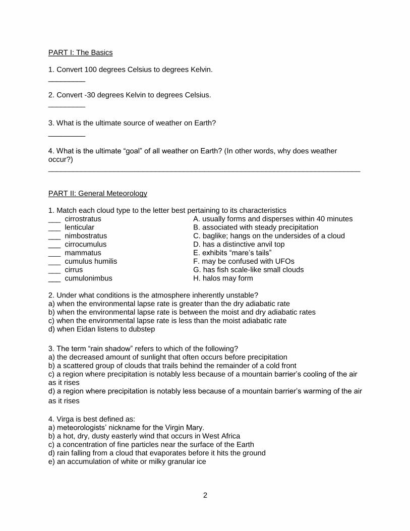
PART I: The Basics 1. Convert 100 degrees Celsius to degrees Kelvin. _________ 2. Convert -30 degrees Kelvin to degrees Celsius. _________
3. What is the ultimate source of weather on Earth?
_________
4. What is the ultimate “goal” of all weather on Earth? (In other words, why does weather occur?) ____________________________________________________________________________ PART II: General Meteorology 1. Match each cloud type to the letter best pertaining to its characteristics ___ cirrostratus A. usually forms and disperses within 40 minutes ___ lenticular B. associated with steady precipitation ___ nimbostratus C. baglike; hangs on the undersides of a cloud ___ cirrocumulus D. has a distinctive anvil top ___ mammatus E. exhibits “mare’s tails” ___ cumulus humilis F. may be confused with UFOs ___ cirrus G. has fish scale-like small clouds ___ cumulonimbus H. halos may form 2. Under what conditions is the atmosphere inherently unstable? a) when the environmental lapse rate is greater than the dry adiabatic rate b) when the environmental lapse rate is between the moist and dry adiabatic rates c) when the environmental lapse rate is less than the moist adiabatic rate d) when Eidan listens to dubstep
3. The term “rain shadow” refers to which of the following? a) the decreased amount of sunlight that often occurs before precipitation b) a scattered group of clouds that trails behind the remainder of a cold front c) a region where precipitation is notably less because of a mountain barrier’s cooling of the air as it rises d) a region where precipitation is notably less because of a mountain barrier’s warming of the air
as it rises
4. Virga is best defined as: a) meteorologists’ nickname for the Virgin Mary. b) a hot, dry, dusty easterly wind that occurs in West Africa c) a concentration of fine particles near the surface of the Earth d) rain falling from a cloud that evaporates before it hits the ground e) an accumulation of white or milky granular ice
3
5. Select all of the following that influence wind direction (there may be more than one answer): a) pressure gradient force b) Coriolis force c) friction d) elastic force e) centripetal force
6. Match the following weather instruments with the correct description: ___ anemometer A. carried aboard weather balloons ___ radiosonde B. measures wind speed ___ hygrometer C. used in determining altitude ___ barometer D. contains a dry bulb and a wet bulb ___ sling psychrometer E. measures humidity 7. Briefly describe the difference between sleet and freezing rain. Use of either the US or international definition of “sleet” will be accepted. ____________________________________________________________________________
____________________________________________________________________________
PART III: The Atmosphere 1. State the percent by volume of the following gases in the Earth’s atmosphere (at surface level
in dry air). Round to the nearest whole percent.
Oxygen: ______
Argon: ______
Nitrogen: ______
2. Give an estimation of the current ppm (parts per million) concentration of carbon dioxide in
the atmosphere. _______
3. In what layer of the atmosphere is there a temperature inversion?
a) troposphere
b) stratosphere
c) mesosphere
d) ionosphere
e) thermosphere
4. Which layer of the atmosphere has the lowest average temperature?
a) troposphere
b) stratosphere
c) mesosphere
d) ionosphere
e) thermosphere
4
5. Which layer of the atmosphere has the lowest amount of thermal energy?
a) troposphere b) stratosphere c) mesosphere d) ionosphere e) thermosphere
6. Briefly explain why the eruption of Mount Pinatubo caused a global temperature decrease of
0.5 degrees Celsius in 1991.
____________________________________________________________________________
____________________________________________________________________________
Part IV: Solar Radiation
1. Rank the following surfaces from 1-5 based on their albedo, 1 being the highest and 5 being
the lowest.
___ grassy field
___ fresh snow
___ forest
___ clouds
___ ocean
2. Two cities have the same mean annual temperatures. Explain why this does not imply that
their temperatures throughout the year are similar.
____________________________________________________________________________
____________________________________________________________________________
____________________________________________________________________________
3. Which of the following correctly describes sunspots?
a) the sunspot itself is cooler than the surrounding corona; the more sunspots, the less solar
radiation the sun emits
b) the sunspot itself is warmer than the surrounding corona; the more sunspots, the less solar
radiation the sun emits
c) the sunspot itself is cooler than the surrounding corona; the more sunspots, the more solar
radiation the sun emits
d) the sunspot itself is warmer than the surrounding corona; the more sunspots, the more solar
radiation the sun emits
5
4. Approximately how many hours of daylight does a person standing at the South Pole receive
on the summer solstice?
a) 0 b) 8 c) 12 d) 16 e) 24 5. Which of the following has the greatest effect on a location’s temperature during a given
season?
a) average daily duration of solar radiation
b) average daily intensity of re-radiated solar radiation
c) average daily percentage of solar radiation reflected by clouds
d) average daily angle of solar radiation
6. Harrison is standing at 30 degrees south latitude. What would be the measure of the angle
between his line of sight and the apparent position of the sun on the winter solstice?
a) 7.5 degrees
b) 30 degrees
c) 53.5 degrees
d) 60 degrees
e) 83.5 degrees
PART V: Celestial Cycles
1. Briefly explain why the seasons in the Northern and Southern Hemisphere are reversed relative to each other. ________________________________________________________________________________________________________________________________________________________ 2. During what Northern Hemisphere season is the Earth closest to the sun? a) spring b) summer c) fall d) winter e) none; the Earth remains an equal distance from the sun throughout the year 3. What is the eccentricity of a perfect circle?
_______
4. What would happen to the seasons if the axial tilt of the Earth increased? a) Summers would get colder and winters would get warmer. b) Summers would get warmer and winters would get colder. c) Summers would get shorter and winters would get longer. d) Summers would get longer and winters would get shorter.
6
5. What would happen to the climate of the Earth if, all other factors constant, the eccentricity of
its orbit doubled?
____________________________________________________________________________
____________________________________________________________________________
____________________________________________________________________________
PART VI: Climate
1. Briefly explain the difference between weather and climate.
____________________________________________________________________________
____________________________________________________________________________
2. Briefly explain the difference between a continental climate and a coastal climate.
____________________________________________________________________________
____________________________________________________________________________
3. Which of the following climate zones is typically subject to the greatest diurnal variation in
temperature?
a) humid subtropical
b) arctic
c) arid
d) Mediterranean
4. Why is Anchorage, Alaska considered to have a subarctic climate under the Koppen climate
classification system?
a) it receives over 75 inches of snowfall every year
b) it is located only a few degrees of latitude south of the Arctic Circle
c) average temperatures there exceed 10 degrees Celsius for between 1 and 3 months of the
year
d) it is located adjacent to a cold ocean current
5. Which of the following best describes a climate that is heavily influenced by monsoons?
a) wet and rainy year-round
b) wet and rainy for part of the year, then very dry for the remainder of the year
c) hot and dry year-round
d) moderated by the trade winds
6. Most of the world’s deserts (excluding Antarctica) are located at:
a) 0 degrees north latitude to 15 degrees north latitude
b) 15 degrees north latitude to 30 degrees north latitude
c) 30 degrees north latitude to 45 degrees north latitude
d) 45 degrees north latitude to 60 degrees north latitude
7
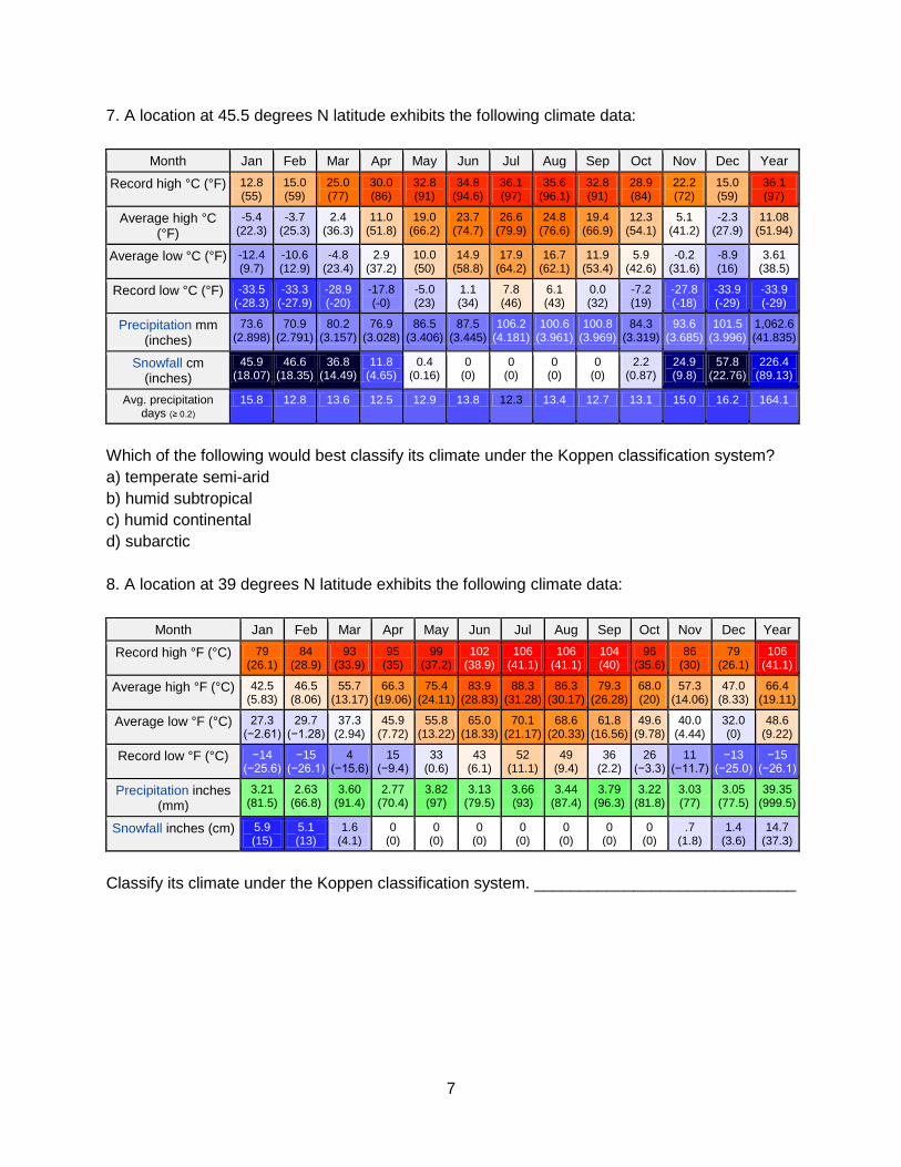
7. A location at 45.5 degrees N latitude exhibits the following climate data:
Month Jan Feb Mar Apr May Jun Jul Aug Sep Oct Nov Dec Year
Record high °C (°F) 12.8 (55)
15.0 (59)
25.0 (77)
30.0 (86)
32.8 (91)
34.8 (94.6)
36.1 (97)
35.6 (96.1)
32.8 (91)
28.9 (84)
22.2 (72)
15.0 (59)
36.1 (97)
Average high °C (°F)
-5.4 (22.3)
-3.7 (25.3)
2.4 (36.3)
11.0 (51.8)
19.0 (66.2)
23.7 (74.7)
26.6 (79.9)
24.8 (76.6)
19.4 (66.9)
12.3 (54.1)
5.1 (41.2)
-2.3 (27.9)
11.08 (51.94)
Average low °C (°F) -12.4 (9.7)
-10.6 (12.9)
-4.8 (23.4)
2.9 (37.2)
10.0 (50)
14.9 (58.8)
17.9 (64.2)
16.7 (62.1)
11.9 (53.4)
5.9 (42.6)
-0.2 (31.6)
-8.9 (16)
3.61 (38.5)
Record low °C (°F) -33.5 (-28.3)
-33.3 (-27.9)
-28.9 (-20)
-17.8 (-0)
-5.0 (23)
1.1 (34)
7.8 (46)
6.1 (43)
0.0 (32)
-7.2 (19)
-27.8 (-18)
-33.9 (-29)
-33.9 (-29)
Precipitation mm (inches)
73.6 (2.898)
70.9 (2.791)
80.2 (3.157)
76.9 (3.028)
86.5 (3.406)
87.5 (3.445)
106.2 (4.181)
100.6 (3.961)
100.8 (3.969)
84.3 (3.319)
93.6 (3.685)
101.5 (3.996)
1,062.6 (41.835)
Snowfall cm (inches)
45.9 (18.07)
46.6 (18.35)
36.8 (14.49)
11.8 (4.65)
0.4 (0.16)
0 (0)
0 (0)
0 (0)
0 (0)
2.2 (0.87)
24.9 (9.8)
57.8 (22.76)
226.4 (89.13)
Avg. precipitation days (≥ 0.2)
15.8 12.8 13.6 12.5 12.9 13.8 12.3 13.4 12.7 13.1 15.0 16.2 164.1
Which of the following would best classify its climate under the Koppen classification system?
a) temperate semi-arid
b) humid subtropical
c) humid continental
d) subarctic
8. A location at 39 degrees N latitude exhibits the following climate data:
Month Jan Feb Mar Apr May Jun Jul Aug Sep Oct Nov Dec Year
Record high °F (°C) 79 (26.1)
84 (28.9)
93 (33.9)
95 (35)
99 (37.2)
102 (38.9)
106 (41.1)
106 (41.1)
104 (40)
96 (35.6)
86 (30)
79 (26.1)
106 (41.1)
Average high °F (°C) 42.5 (5.83)
46.5 (8.06)
55.7 (13.17)
66.3 (19.06)
75.4 (24.11)
83.9 (28.83)
88.3 (31.28)
86.3 (30.17)
79.3 (26.28)
68.0 (20)
57.3 (14.06)
47.0 (8.33)
66.4 (19.11)
Average low °F (°C) 27.3 (−2.61)
29.7 (−1.28)
37.3 (2.94)
45.9 (7.72)
55.8 (13.22)
65.0 (18.33)
70.1 (21.17)
68.6 (20.33)
61.8 (16.56)
49.6 (9.78)
40.0 (4.44)
32.0 (0)
48.6 (9.22)
Record low °F (°C) −14 (−25.6)
−15 (−26.1)
4 (−15.6)
15 (−9.4)
33 (0.6)
43 (6.1)
52 (11.1)
49 (9.4)
36 (2.2)
26 (−3.3)
11 (−11.7)
−13 (−25.0)
−15 (−26.1)
Precipitation inches (mm)
3.21 (81.5)
2.63 (66.8)
3.60 (91.4)
2.77 (70.4)
3.82 (97)
3.13 (79.5)
3.66 (93)
3.44 (87.4)
3.79 (96.3)
3.22 (81.8)
3.03 (77)
3.05 (77.5)
39.35 (999.5)
Snowfall inches (cm) 5.9 (15)
5.1 (13)
1.6 (4.1)
0 (0)
0 (0)
0 (0)
0 (0)
0 (0)
0 (0)
0 (0)
.7 (1.8)
1.4 (3.6)
14.7 (37.3)
Classify its climate under the Koppen classification system. _____________________________
8
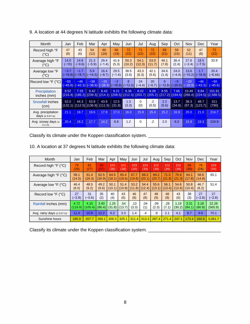
9. A location at 44 degrees N latitude exhibits the following climate data:
Month Jan Feb Mar Apr May Jun Jul Aug Sep Oct Nov Dec Year
Record high °F (°C)
47 (8)
43 (6)
54 (12)
60 (16)
66 (19)
72 (22)
71 (22)
72 (22)
69 (21)
59 (15)
52 (11)
47 (8)
72 (22)
Average high °F (°C)
14.0 (−10)
14.8 (−9.6)
21.3 (−5.9)
29.4 (−1.4)
41.6 (5.3)
50.3 (10.2)
54.1 (12.3)
53.0 (11.7)
46.1 (7.8)
36.4 (2.4)
27.6 (−2.4)
18.5 (−7.5)
33.9
Average low °F (°C)
−3.7 (−19.8)
−1.7 (−18.7)
5.9 (−14.5)
16.4 (−8.7)
29.5 (−1.4)
38.5 (3.6)
43.3 (6.3)
42.1 (5.6)
34.6 (1.4)
24.0 (−4.4)
13.6 (−10.2)
1.7 (−16.8)
20.4 (−6.44)
Record low °F (°C) −50 (−45.6)
−46 (−43.3)
−38 (−38.9)
−20 (−28.9)
−2 (−18.9)
8 (−13.3)
24 (−4.4)
20 (−6.7)
9 (−12.8)
−5 (−20.6)
−20 (−28.9)
−46 (−43.3)
−50 (−45.6)
Precipitation inches (mm)
8.52 (216.4)
7.33 (186.2)
9.42 (239.3)
8.43 (214.1)
8.21 (208.5)
8.36 (212.3)
8.02 (203.7)
8.08 (205.2)
8.55 (217.2)
7.66 (194.6)
10.49 (266.4)
8.84 (224.5)
101.91 (2,588.5)
Snowfall inches (cm)
52.0 (132.1)
44.3 (112.5)
53.9 (136.9)
43.9 (111.5)
12.5 (31.8)
1.3 (3.3)
0 (0)
.2 (0.5)
2.2 (5.6)
13.7 (34.8)
38.3 (97.3)
48.7 (123.7)
311 (790)
Avg. precipitation days (≥ 0.01 in)
21.1 18.7 19.6 17.9 17.0 16.0 15.9 15.4 15.2 16.9 20.0 21.0 214.7
Avg. snowy days (≥
0.1 in) 20.4 18.2 17.7 14.2 6.6 1.2 0 .2 2.0 9.2 15.9 19.3 124.9
Classify its climate under the Koppen classification system. _____________________________
10. A location at 37 degrees N latitude exhibits the following climate data:
Month Jan Feb Mar Apr May Jun Jul Aug Sep Oct Nov Dec Year
Record high °F (°C) 79 (26)
81 (27)
99 (37)
100 (38)
101 (38)
103 (39)
103 (39)
102 (39)
102 (39)
102 (39)
86 (30)
76 (24)
103 (39)
Average high °F (°C) 58.1 (14.5)
61.4 (16.3)
62.5 (16.9)
64.5 (18.1)
65.4 (18.6)
67.7 (19.8)
68.2 (20.1)
69.2 (20.7)
71.3 (21.8)
70.4 (21.3)
64.1 (17.8)
58.6 (14.8)
65.1
Average low °F (°C) 46.4 (8.0)
48.5 (9.2)
49.2 (9.6)
50.1 (10.1)
51.4 (10.8)
53.2 (11.8)
54.4 (12.4)
55.6 (13.1)
56.1 (13.4)
54.6 (12.6)
50.8 (10.4)
46.7 (8.2)
51.4
Record low °F (°C) 27 (−2.8)
31 (−0.6)
35 (2)
40 (4)
43 (6)
46 (8)
47 (8)
48 (9)
48 (9)
43 (6)
38 (3)
27 (−2.8)
27 (−2.8)
Rainfall inches (mm) 4.72 (119.9)
4.15 (105.4)
3.40 (86.4)
1.25 (31.8)
.54 (13.7)
.13 (3.3)
.04 (1)
.09 (2.3)
.28 (7.1)
1.19 (30.2)
3.31 (84.1)
3.18 (80.8)
22.28 (565.9)
Avg. rainy days (≥ 0.01 in) 11.4 10.8 11.2 6.2 3.3 1.4 .4 .9 2.1 4.1 8.7 9.6 70.1
Sunshine hours 185.9 207.7 269.1 309.3 325.1 311.4 313.3 287.4 271.4 247.1 173.4 160.6 3,061.7
Classify its climate under the Koppen classification system. _____________________________
9
11. Choose all of the following that are NOT true:
I. The Koppen climate classification system is based on both the temperature and annual
amount of precipitation of a region
II. A city that is classified as having a humid continental climate under the Koppen classification
system would possibly have a Thornthwaite index of -20
III. The Thronthwaite system of climate classification is not directly based on temperature
a) I only
b) II only
c) III only
d) II and III only
e) I, II, and III
12. Name the semi-permanent high pressure system that influences the angle of the jet stream
along the eastern coast of North America during the Northern Hemisphere hurricane season.
____________________________
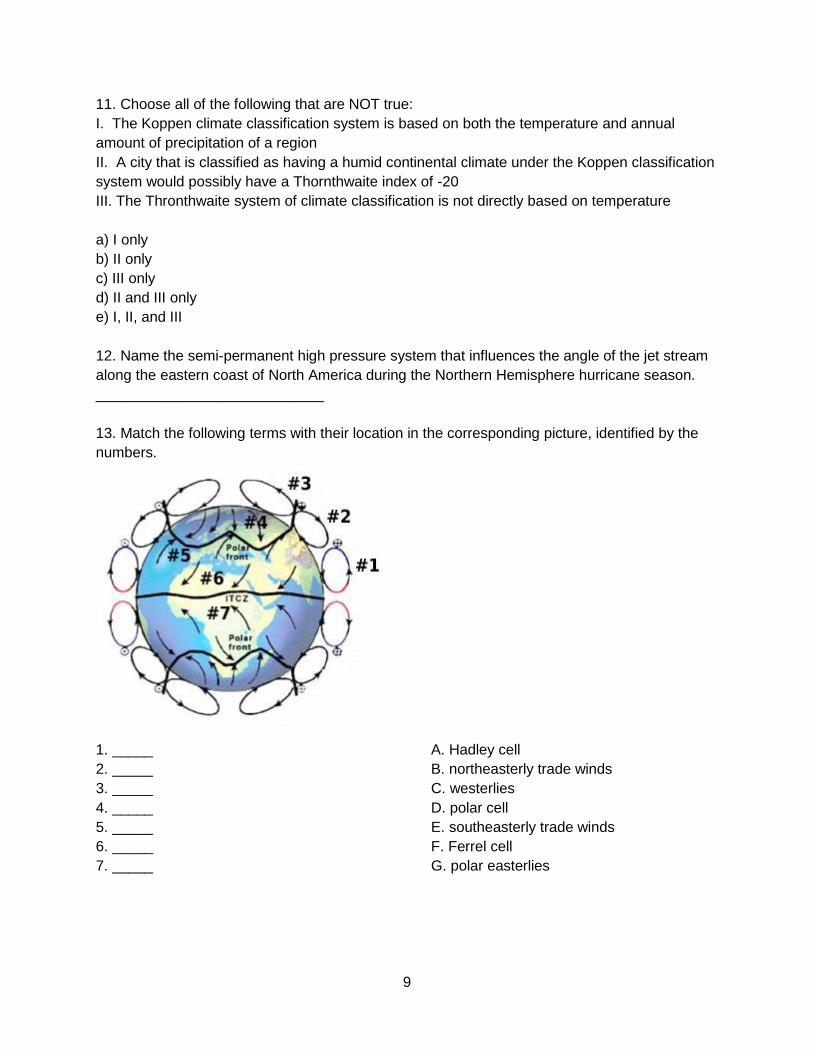
13. Match the following terms with their location in the corresponding picture, identified by the
numbers.
1. _____ A. Hadley cell
2. _____ B. northeasterly trade winds
3. _____ C. westerlies
4. _____ D. polar cell
5. _____ E. southeasterly trade winds
6. _____ F. Ferrel cell
7. _____ G. polar easterlies
10
14. Which of the following wind patterns is known for causing rapid warm-ups in winter weather
along the northwestern United States via adiabatic warming?
a) Chinook
b) Haboob
c) Panhandle hook
d) Santa Ana
15. What is the main driving force in the thermohaline circulation (ocean conveyer belt)?
________________________________________
16. During El Nino, the cool, nutrient-rich sea water normally found along the coast of Peru is
replaced by warmer water depleted of nutrients. Describe the effect of this phenomenon on
Peru’s economy.
____________________________________________________________________________
____________________________________________________________________________
17. About how often does El Nino occur?
a) annually
b) every 5 years
c) variable; anywhere from a few years to decades
d) every decade
e) every century
18. During El Nino, the easterly trade winds weaken. Why does this cause thunderstorm and
flood-like conditions for eastern South America (Peru and Ecuador), yet dry conditions for
Indonesia and Australia?
____________________________________________________________________________
____________________________________________________________________________
____________________________________________________________________________
Part VII: Paleoproxies // Ancient Climate
1. Select all of the following found in an ice core sample that would help a scientist date that
section of the sample.
a) pollen
b) trapped air bubbles
c) layering
d) volcanic ash
e) oxygen isotope changes
11
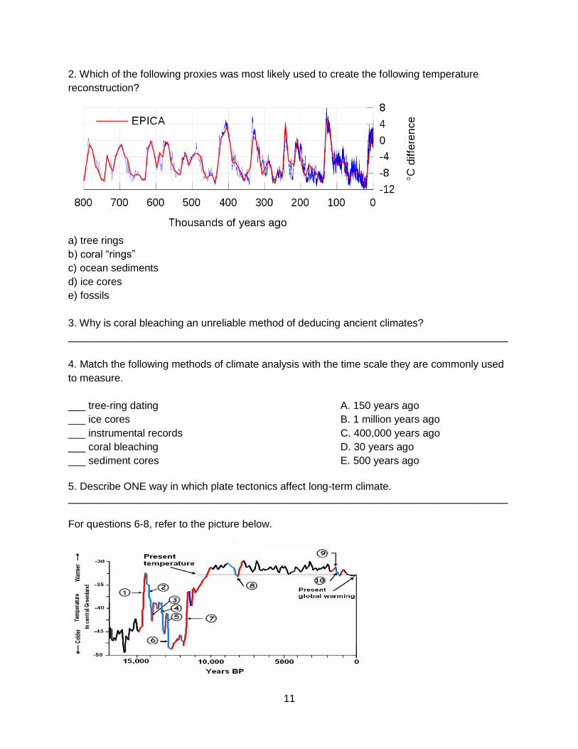
2. Which of the following proxies was most likely used to create the following temperature
reconstruction?
a) tree rings
b) coral “rings”
c) ocean sediments
d) ice cores
e) fossils
3. Why is coral bleaching an unreliable method of deducing ancient climates?
____________________________________________________________________________
4. Match the following methods of climate analysis with the time scale they are commonly used
to measure.
___ tree-ring dating A. 150 years ago
___ ice cores B. 1 million years ago
___ instrumental records C. 400,000 years ago
___ coral bleaching D. 30 years ago
___ sediment cores E. 500 years ago
5. Describe ONE way in which plate tectonics affect long-term climate. ____________________________________________________________________________
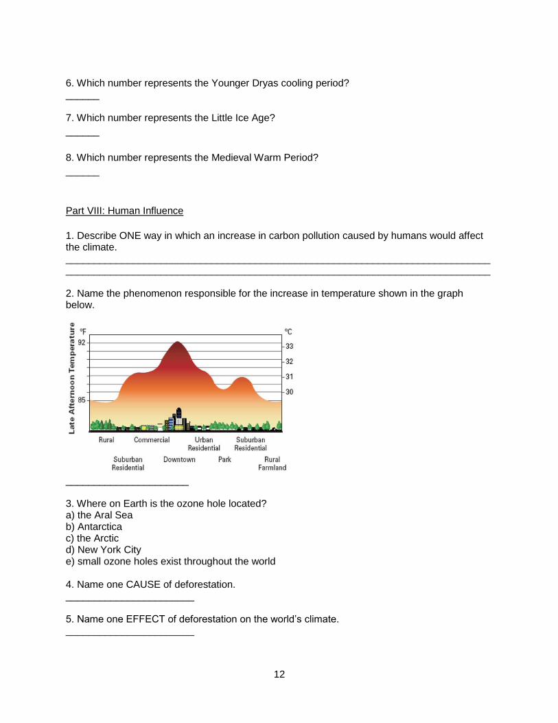
For questions 6-8, refer to the picture below.
12
6. Which number represents the Younger Dryas cooling period? ______ 7. Which number represents the Little Ice Age?
______
8. Which number represents the Medieval Warm Period?
______
Part VIII: Human Influence
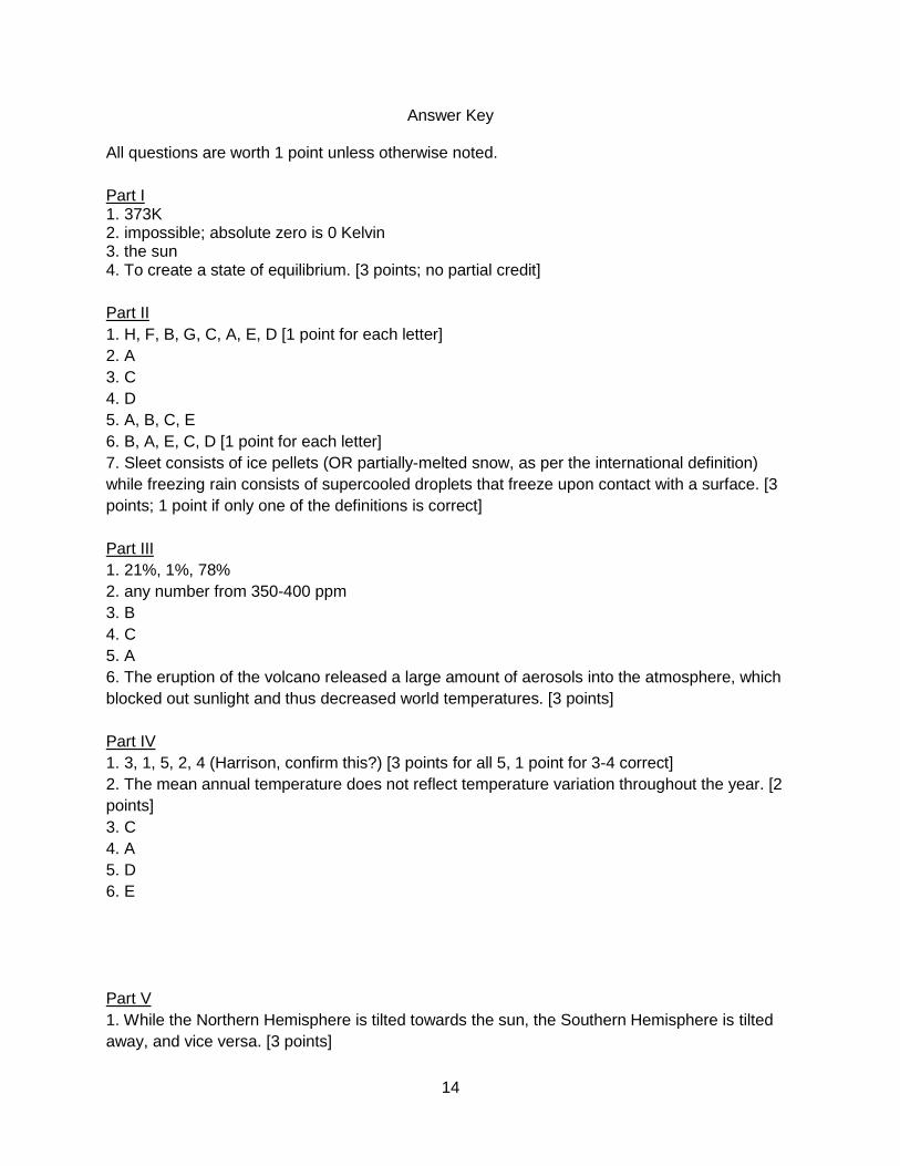
1. Describe ONE way in which an increase in carbon pollution caused by humans would affect the climate. ________________________________________________________________________________________________________________________________________________________ 2. Name the phenomenon responsible for the increase in temperature shown in the graph below.
______________________ 3. Where on Earth is the ozone hole located? a) the Aral Sea b) Antarctica c) the Arctic d) New York City e) small ozone holes exist throughout the world 4. Name one CAUSE of deforestation. _______________________ 5. Name one EFFECT of deforestation on the world’s climate. _______________________

13
6. Over the past 50 years, Lake Chad’s size has decreased by over 95% of its original surface area. Describe TWO adverse effects of this shrinking. They do not have to be climate related, but be specific. ____________________________________________________________________________
____________________________________________________________________________
____________________________________________________________________________
14
Answer Key
All questions are worth 1 point unless otherwise noted.
Part I 1. 373K 2. impossible; absolute zero is 0 Kelvin 3. the sun 4. To create a state of equilibrium. [3 points; no partial credit]
Part II
1. H, F, B, G, C, A, E, D [1 point for each letter]
2. A
3. C
4. D
5. A, B, C, E
6. B, A, E, C, D [1 point for each letter]
7. Sleet consists of ice pellets (OR partially-melted snow, as per the international definition)
while freezing rain consists of supercooled droplets that freeze upon contact with a surface. [3
points; 1 point if only one of the definitions is correct]
Part III
1. 21%, 1%, 78%
2. any number from 350-400 ppm
3. B
4. C
5. A
6. The eruption of the volcano released a large amount of aerosols into the atmosphere, which
blocked out sunlight and thus decreased world temperatures. [3 points]
Part IV
1. 3, 1, 5, 2, 4 (Harrison, confirm this?) [3 points for all 5, 1 point for 3-4 correct]
2. The mean annual temperature does not reflect temperature variation throughout the year. [2
points]
3. C
4. A
5. D
6. E
Part V
1. While the Northern Hemisphere is tilted towards the sun, the Southern Hemisphere is tilted
away, and vice versa. [3 points]
15
2. D
3. 0
4. B
5. Northern hemisphere seasons would be milder, and southern hemisphere seasons would be
less mild. [3 points]
Part VI
1. Weather describes day-to-day atmospheric interactions, while climate is weather observed
over longer periods of time, taking into account trends and significant anomalies. [3 points]
2. A continental climate has greater temperature variation throughout the year than does a
coastal climate. [2 points]
3. C
4. C
5. B
6. B
7. C
8. humid subtropical
9. subarctic
10. Mediterranean
11. B
12. Bermuda high
13. A, F, D, G, C, B, E [1 point each]
14. D
15. density of warm vs. cold water; density of saline vs. pure water [3 points; 1 point if only one
is named]
16. Fish cannot survive in such nutrient-poor waters; because the fishing industry is a large part
of Peru’s economy, it suffers greatly. [3 points]
17. B
18. Warm water is no longer pushed to the west by the easterly trade winds. The resulting
upwelling of warm water near the coast of South America fuels thunderstorms, while the loss of
warm water in Australia and Indonesia creates a lack of rain. [5 points; partial credit can be
given]
Part VII
1. C, D
2. D
3. There is no way of obtaining past records of bleaching; it must be actively observed. [2
points]
4. E, C, A, D, B [1 point each]
5. Plate tectonics may increase volcanism OR create more sea floor. [2 points]
6. 6
7. 10
8. 9
16
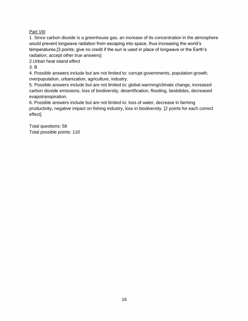
Part VIII
1. Since carbon dioxide is a greenhouse gas, an increase of its concentration in the atmosphere
would prevent longwave radiation from escaping into space, thus increasing the world’s
temperatures.[3 points; give no credit if the sun is used in place of longwave or the Earth’s
radiation; accept other true answers]
2.Urban heat island effect
3. B
4. Possible answers include but are not limited to: corrupt governments, population growth,
overpopulation, urbanization, agriculture, industry.
5. Possible answers include but are not limited to: global warming/climate change, increased
carbon dioxide emissions, loss of biodiversity, desertification, flooding, landslides, decreased
evapotranspiration.
6. Possible answers include but are not limited to: loss of water, decrease in farming
productivity, negative impact on fishing industry, loss in biodiversity. [2 points for each correct
effect]
Total questions: 58
Total possible points: 110


![[Mathematical Olympiad] Math Olympiad Tutorials](https://img.pdfslide.us/doc/110x75/55cf97a6550346d03392cb7e/mathematical-olympiad-math-olympiad-tutorials.jpg)