Embed Size (px)
Citation preview
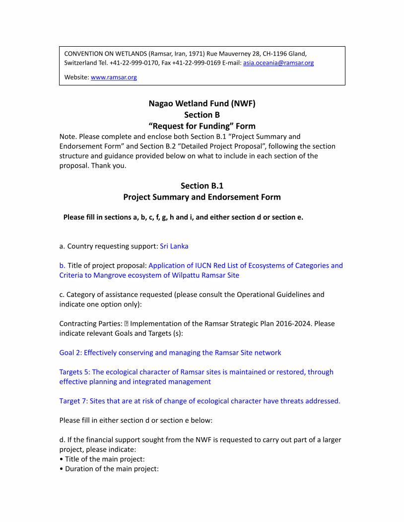
Nagao Wetland Fund (NWF)
Section B “Request for Funding” Form
Note. Please complete and enclose both Section B.1 “Project Summary and Endorsement Form” and Section B.2 “Detailed Project Proposal”, following the section structure and guidance provided below on what to include in each section of the proposal. Thank you.
Section B.1 Project Summary and Endorsement Form
Please fill in sections a, b, c, f, g, h and i, and either section d or section e. a. Country requesting support: Sri Lanka b. Title of project proposal: Application of IUCN Red List of Ecosystems of Categories and Criteria to Mangrove ecosystem of Wilpattu Ramsar Site c. Category of assistance requested (please consult the Operational Guidelines and indicate one option only): Contracting Parties: Implementation of the Ramsar Strategic Plan 2016-2024. Please indicate relevant Goals and Targets (s): Goal 2: Effectively conserving and managing the Ramsar Site network Targets 5: The ecological character of Ramsar sites is maintained or restored, through effective planning and integrated management Target 7: Sites that are at risk of change of ecological character have threats addressed. Please fill in either section d or section e below: d. If the financial support sought from the NWF is requested to carry out part of a larger project, please indicate: • Title of the main project: • Duration of the main project:
CONVENTION ON WETLANDS (Ramsar, Iran, 1971) Rue Mauverney 28, CH-1196 Gland, Switzerland Tel. +41-22-999-0170, Fax +41-22-999-0169 E-mail: [email protected]
Website: www.ramsar.org
• Total cost of the main project: • Amount requested from the NWF: • Have the main project and the other funds been approved: Yes No Operational Guidelines for NWF, 2016-2021, page 10 • If yes, please indicate the sources of these funds, showing whether the source is incountry or external: e. If the proposed project is a stand-alone activity, please indicate: • Duration of the activities to be covered by NWF grant: 12 Months • Amount requested from the Ramsar NWF: US$ 18,000 • Other financial contributions (including in-kind) – indicate whether these are from incountry or external sources: US$ 15,833.33 f. Name, address (including phone/fax numbers and e-mail address) and website of the recipient agency, i.e. the institution responsible for the project, specifying the name and contact details of the person responsible for preparing and executing the project. Sevvandi Jayakody PhD Environmental Foundation (Guarantee) Limited, No. Mobile: 0094 777947907 Telephone: 0094 112890992 Fax: 0094 112890663 Web: www.efl.lk g. Summary (maximum 500 words) Describe background, justification, objectives and intended follow-up. Indicate if the project will be carried out in a Ramsar site(s) or how it otherwise contributes to the implementation of the Ramsar Strategic Plan 2016-2024 and the fulfillment of its objectives: The IUCN Red List of Ecosystems is a global framework for monitoring the status of ecosystems. It is part of the growing toolbox for assessing risks to biodiversity and aims to support conservation, resource use, and management decisions by identifying ecosystems most at risk of biodiversity loss. The protocol comprises five rule-based criteria (A-E) for assigning ecosystems to a risk category. Two of these criteria assess spatial symptoms of ecosystem collapse: declining distribution (A) and restricted distribution (B). Two criteria assess functional symptoms of ecosystem collapse: environmental degradation (C) and disruption of biotic processes and interactions (D). Multiple threats and symptoms can be integrated in a model of ecosystem dynamics to produce quantitative estimates of the risk of collapse (E).
The protocol has been advocated widely but the applicability has been limited especially in Asia. Recent reviews on status of biodiversity have explicitly indicated that health of tropical ecosystems is declining and some aquatic systems are reaching the tipping point, assessing the vulnerability of ecosystems is essential. The wetlands of Sri Lanka are the lifeline of numerous fauna and flora as well as humans. At present they are managed mostly by precautionary approach principles with limited information on the status of systems. Among the declared Ramsar sites of Sri Lanka, Wilpattu Ramsar site is unique as it consists of several aquatic ecosystems including coral reefs, sea grass beds, ox bow type lakes, man made reservoirs, salt marshes and mangroves. The mangrove ecosystem in Wilpattu Ramsar site around Kala Oya estuary is one of the largest, linking seascapes with landscape. Being the first stopover for migratory birds, the mangrove ecosystem of Wilpattu Ramsar site provides landing sites, food and shelter. Amongst different ecosystems mentioned above, mangroves are also widely used for fishing, tourism and are encroached. The plight of mangroves in Wilpattu Ramsar site depicts the general status of mangroves in the country. Hence, assessing mangrove ecosystem of Wilpattu Ramsar site using protocols developed for IUCN Red List of Ecosystems will set guidance for assessments in other mangrove ecosystems as well as set a bench mark on current status of the ecosystem. Hence, the objective of this study is to apply protocols developed by IUCN Red List of Ecosystems to mangrove ecosystem of Wilpattu Ramsar site and to check the feasibility of applying the protocol in Sri Lanka. At the same time, this study will be conducted as a pilot with the objective of establishing feasibility of using the protocol for other aquatic ecosystems and to understand data needs for reliable assessments. Ramsar Strategic Plan 2016-2024 advocates wise us after assessment of status for the long term planning of reducing/ removing threats to aquatic systems. Hence, intended outcomes from this study enable implementing the actions of the plan. The methodology will follow the guidelines given for assessment for a 50 year period. In addition to using existing data, data gaps for five criteria will be collected from field visits, planned fauna and flora assessments, expert consultations and stakeholder meetings. Once assessment is completed, a national level workshop will be conducted to disseminate the outcome as well as to plan strategies to ensure ecosystem is maintained at optimal level. The pilot will also be used to devise strategies to extend such studies to other aquatic ecosystems.
Section B.2 Structure and Contents of Detailed Project Proposal
Notes: i) Please follow the section headings and sequence and the guidance for what to include in each section. ii) Please use a maximum of five (5) pages (A4 size paper) to provide detailed information on your proposal, following the headings and instructions given below. Please do not use margins of less than 1.5 cm, and do not use letters smaller than 10-point font size. Details of proposal A. Background and justification Ecosystems are managed by countries under provisions from international and national policies related to conservation of biodiversity, landscapes and migration of species. The focus for species conservation has been addressed by the systematic investigations that are related to establishing conservation status of species under IUCN Red listing. Hence numerous species focused conservation efforts are in place and outcomes of such interventions are measured from changes to a species conservation status. However, ecosystem conservation is often carried out either under data deficient conditions or through intuition focusing mostly declining spatial area of a given ecosystem. The lack of a baseline on status of an ecosystem has been discussed and the global solution that has been proposed for this is IUCN Red List of Ecosystems (RLE) of Categories. The proposed protocol provides the information necessary to conduct a robust and repeatable ecosystem risk assessment. The categories Critically Endangered, Endangered and Vulnerable indicate threatened ecosystems and are defined by quantitative and qualitative criteria. It has flexibility to assess risks to ecosystems that vary greatly in biological and environmental characteristics, scales of organization, and amounts of available data. The RLE risk assessment protocol was designed to be flexible for application at multiple spatial scales and with a range of data types. National Strategic Biodiversity Action Plan 2016-2022 (NBSAP) of Sri Lanka has mentioned the need for RLE for identified ecosystems. However to date RLE assessments have not been conducted in Sri Lanka. At the same time Sri Lanka has just validated policy on conservation and sustainable use of mangroves. Both NBSAP and policy highlight the need for assessment of status of mangroves. A good attempt would be to apply current protocol developed for RLE on pilot scale and for this purpose considering the existing Ramsar sites, Wilpattu Ramsar site is
CONVENTION ON WETLANDS (Ramsar, Iran, 1971) Rue Mauverney 28, CH-1196 Gland, Switzerland Tel. +41-22-999-0170, Fax +41-22-999-0169
E-mail: [email protected] Website: www.ramsar.org
selected for specific reasons. Wilpattu Ramsar site has some information collected at different time periods that warrant application of protocol, is one of the largest contagious mangrove ecosystem in the country, threats are known and can be qualified, stakeholders are mainly the fishing and farming communities in the southern border of the site and currently a permanent population of over 3600 inhabit the area. This assessment comes in the right time as in recent years new threats such as a move to dump garbage, illegal tourism ventures, sand mining in river mouth has been highlighted.
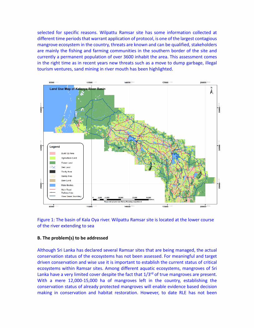
Figure 1: The basin of Kala Oya river. Wilpattu Ramsar site is located at the lower course of the river extending to sea B. The problem(s) to be addressed Although Sri Lanka has declared several Ramsar sites that are being managed, the actual conservation status of the ecosystems has not been assessed. For meaningful and target driven conservation and wise use it is important to establish the current status of critical ecosystems within Ramsar sites. Among different aquatic ecosystems, mangroves of Sri Lanka have a very limited cover despite the fact that 1/3rd of true mangroves are present. With a mere 12,000-15,000 ha of mangroves left in the country, establishing the conservation status of already protected mangroves will enable evidence based decision making in conservation and habitat restoration. However, to date RLE has not been
attempted and this project aims to conduct the first RLE on a pilot scale to establish the conservation status of mangroves of Wilpattu Ramsar site as well as to understand the process for future application in other areas and ecosystem. C. Objective(s) General Objective(s): To establish the conservation status of mangrove ecosystem of Wilpattu Ramsar Sanctuary through application of IUCN Red List of Ecosystems protocol as a pilot study for effective conservation and addressing of threats. This objective can assist achieving of goal 2 Effectively conserving and managing the Ramsar Site network) and targets 5 (The ecological character of Ramsar Sites is maintained or restored, through effective planning and integrated management) and 7 (Sites that are at risk of change of ecological character have threats addressed). Specific Objective(s): 1. To conduct a RLE assessment for mangrove ecosystem of Wilpattu Ramsar site. 2. To establish the RLE conservation category for mangrove ecosystem of Wilpattu Ramsar site 3. To develop strategies and actions for conservation and wise use of mangrove ecosystem of Wilpattu Ramsar site based on the outcomes of the assessment 4. To raise national awareness on use of RLE for ecosystem assessment and status of mangrove ecosystem of Wilpattu Ramsar site whilst sharing the lessons learnt from pilot study D. Outputs 1. RLE category of mangrove ecosystem of Wilpattu Ramsar site. 2. A report on application of RLE protocol. 3. A strategic plan for mangrove ecosystem of Wilpattu Ramsar Site based on RLE category. 4. Trained and empowered personnel from Department of Wildlife Conservation and Biodiversity Secretariat on application of RLE protocols. E. Activities 1. Conduct data collection exercises This is for establishing data needs for five categories as per RLE with desk based studies. All published and unpublished data will be collected from government and non- government institutions, academia, naturalists, sociologists. Maps will also be collected and where possible satellite imagery will be obtained with permission. The data will be
used to classify, validate and create time series of maps, to estimate relative severity and extent of degradation and to select appropriate biotic and abiotic variables. 2. Purchase satellite data for the study area Satellite imagery of the area will be purchased for the past 10-20 years if available. This imagery will be used to determine the extent of ecosystem and reduction in distribution. 3. Conduct expert consultation through an online questionnaire to verify existing data. Approximately 75 questionnaires to be distributed using Google forms using a pre-tested questionnaire to collect unreported current data as well as to gather information to determine potential variables suitable for assessing the severity of environmental degradation. 4. Conduct 20 days of field work to establish the present extent, flora, fauna and water quality in Wilpattu mangrove ecosystem with rapid assessment protocols Rapid environmental assessment protocols will be used in determining the current biotic and abiotic characteristics of the system and land use. Two zoologists, one botanist and one water quality expert will work in the field for assessment. This rapid assessment will be conducted over a period of 4 months. Current mangrove cover, species and characteristic fauna will be assessed. 5. Conduct one regional level stakeholder consultation to establish threats and issues of ecosystem. 30 participants, interviewer based assessment and online surveys Interviews and an online survey will be conducted to establish the threats, their severity and significance as per the protocol (Bland, L.M., Keith, D.A., Miller, R.M., Murray, N.J. and Rodríguez, J.P. (eds.) (2017). Guidelines for the application of IUCN Red List of Ecosystems Categories and Criteria, Version 1.1. Gland, Switzerland: IUCN. Ix + 99pp) 6. One day workshop to determine the scores for each category of RLE and to establish the status. 30 experts from government, non-government sector, academia, naturalists etc. This workshop will be conducted to decide on appropriate models for section E of the protocol assessment (quantitative risk analysis). Selection of model type (mechanistic, spatial or empirical), parameterization will be discussed and a suitable model will be agreed upon. In the same workshop expert ranking and scores will be obtained for sections A to D of protocol. 7. Develop a report on outcome of the pilot study
A report outlining the major outcomes will be produced along with a strategic plan for mangrove ecosystem of Wilpattu Ramsar site based on RLE category outcome for a period of 5 years. The report will be validated online. The validated report will be submitted to the report to Department of Wildlife Conservation. 8. Conduct a lessons learnt workshop for officials of Biodiversity Secretariat. 10-15 selected staff members. Since national focal point for conducting RLE is Biodiversity Secretariat a workshop will be conducted to share the lessons and challenges 9. National and international level presentations at symposia and publishing the outcome in relevant journals We intend presenting the outcomes at national and international forums as well as to come up with at least one peer reviewed journal article. The conservation status score obtained will be widely published using our existing communication tools in social media. Nagao Wetland Fund will be acknowledged in all communications. F. Logical frame of the project Use the table below to summarize the activities undertaken to produce each output and to reach each objective. This table should be consistent with the paragraphs B, C, D and E above. It will be used to assess the project’s progress.
Problems Objectives Outputs Activities Lack of an assessment on status of mangrove ecosystem in Wilpattu Ramsar site
1. To conduct a RLE assessment for mangrove ecosystem of Wilpattu Ramsar site.
1. RLE category of mangrove ecosystem of Wilpattu Ramsar site
1.1. Conduct data collection for establishing data needs for five categories as per RLE with desk based studies 1.2. Purchase satellite data for the study area 1.3. Conduct expert consultation through an online questionnaire to
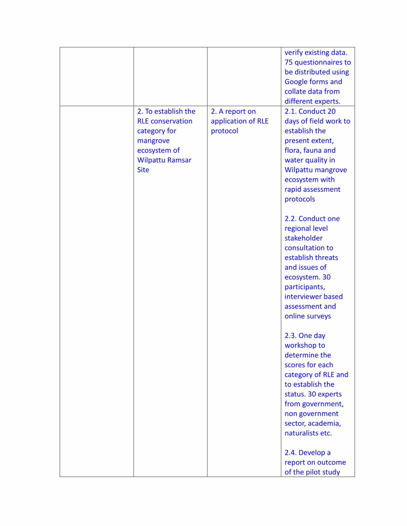
verify existing data. 75 questionnaires to be distributed using Google forms and collate data from different experts.
2. To establish the RLE conservation category for mangrove ecosystem of Wilpattu Ramsar Site
2. A report on application of RLE protocol
2.1. Conduct 20 days of field work to establish the present extent, flora, fauna and water quality in Wilpattu mangrove ecosystem with rapid assessment protocols 2.2. Conduct one regional level stakeholder consultation to establish threats and issues of ecosystem. 30 participants, interviewer based assessment and online surveys 2.3. One day workshop to determine the scores for each category of RLE and to establish the status. 30 experts from government, non government sector, academia, naturalists etc. 2.4. Develop a report on outcome of the pilot study
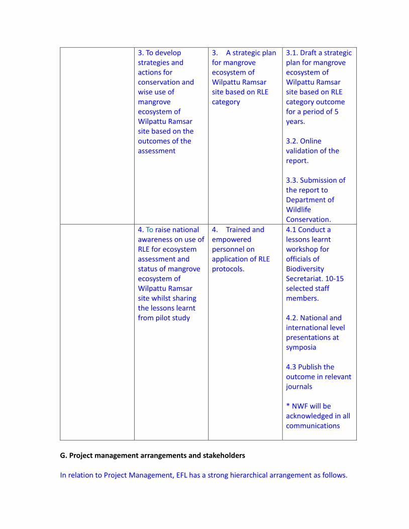
3. To develop strategies and actions for conservation and wise use of mangrove ecosystem of Wilpattu Ramsar site based on the outcomes of the assessment
3. A strategic plan for mangrove ecosystem of Wilpattu Ramsar site based on RLE category
3.1. Draft a strategic plan for mangrove ecosystem of Wilpattu Ramsar site based on RLE category outcome for a period of 5 years. 3.2. Online validation of the report. 3.3. Submission of the report to Department of Wildlife Conservation.
4. To raise national awareness on use of RLE for ecosystem assessment and status of mangrove ecosystem of Wilpattu Ramsar site whilst sharing the lessons learnt from pilot study
4. Trained and empowered personnel on application of RLE protocols.
4.1 Conduct a lessons learnt workshop for officials of Biodiversity Secretariat. 10-15 selected staff members. 4.2. National and international level presentations at symposia 4.3 Publish the outcome in relevant journals * NWF will be acknowledged in all communications
G. Project management arrangements and stakeholders In relation to Project Management, EFL has a strong hierarchical arrangement as follows.
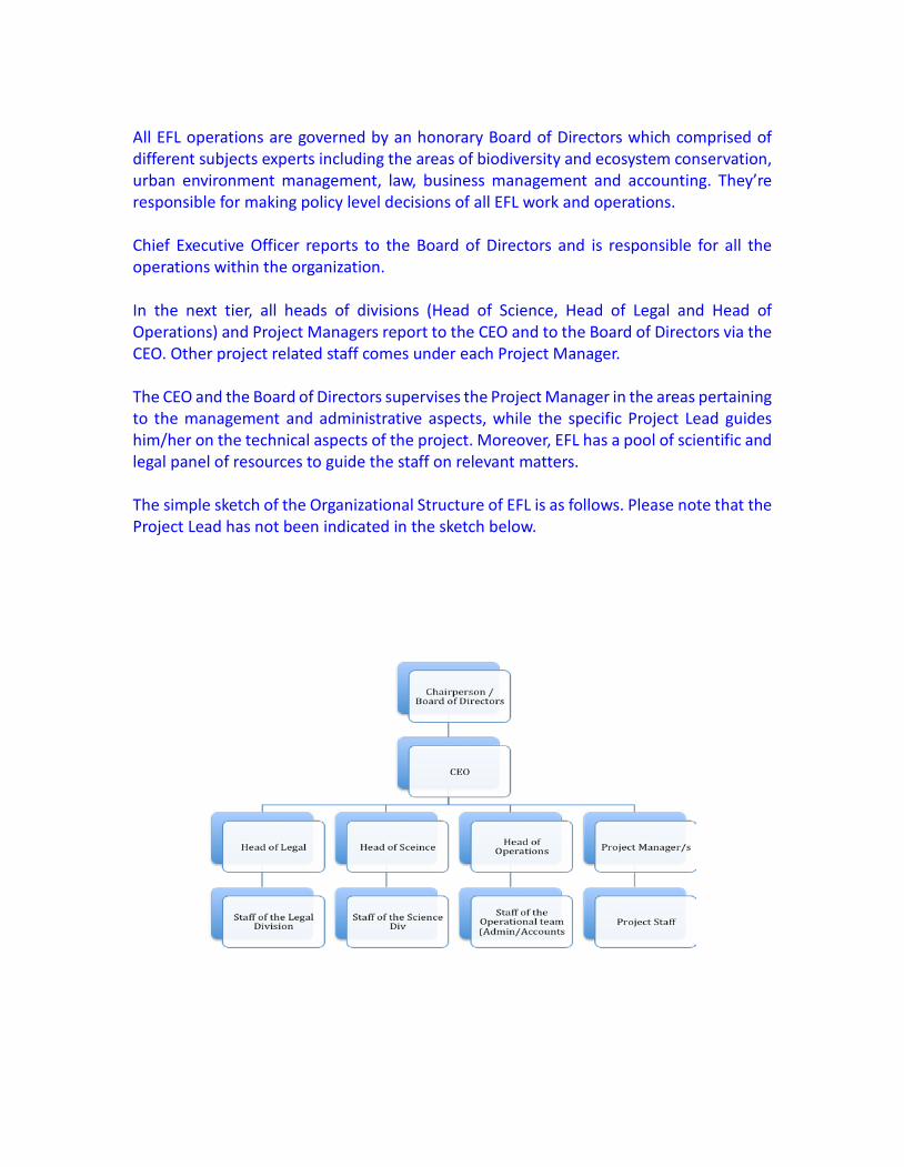
All EFL operations are governed by an honorary Board of Directors which comprised of different subjects experts including the areas of biodiversity and ecosystem conservation, urban environment management, law, business management and accounting. They’re responsible for making policy level decisions of all EFL work and operations. Chief Executive Officer reports to the Board of Directors and is responsible for all the operations within the organization. In the next tier, all heads of divisions (Head of Science, Head of Legal and Head of Operations) and Project Managers report to the CEO and to the Board of Directors via the CEO. Other project related staff comes under each Project Manager. The CEO and the Board of Directors supervises the Project Manager in the areas pertaining to the management and administrative aspects, while the specific Project Lead guides him/her on the technical aspects of the project. Moreover, EFL has a pool of scientific and legal panel of resources to guide the staff on relevant matters. The simple sketch of the Organizational Structure of EFL is as follows. Please note that the Project Lead has not been indicated in the sketch below.
EFL Financial Management is annually audited by a reputed audit firm and all financial reports are produced by Ernst and Young, one of the internationally reputed audit and financial management firms. The annual audit includes the auditing of all the projects and project management processes including other things. Moreover, each project is embedded with a monitoring and evaluation component within the project to assess the technical progress against the defined indicators for outcomes and objectives. H. Work Plan A schedule should be presented for production of all the outputs of the proposed project during the life of the project. This work plan should indicate the order in which activities will be undertaken so as to show the sequence and relationship between activities.
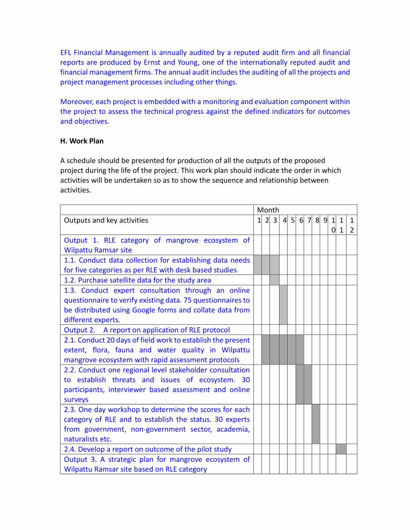
Month Outputs and key activities 1 2 3 4 5 6 7 8 9 1
0 11
12
Output 1. RLE category of mangrove ecosystem of Wilpattu Ramsar site
1.1. Conduct data collection for establishing data needs for five categories as per RLE with desk based studies
1.2. Purchase satellite data for the study area 1.3. Conduct expert consultation through an online questionnaire to verify existing data. 75 questionnaires to be distributed using Google forms and collate data from different experts.
Output 2. A report on application of RLE protocol 2.1. Conduct 20 days of field work to establish the present extent, flora, fauna and water quality in Wilpattu mangrove ecosystem with rapid assessment protocols
2.2. Conduct one regional level stakeholder consultation to establish threats and issues of ecosystem. 30 participants, interviewer based assessment and online surveys
2.3. One day workshop to determine the scores for each category of RLE and to establish the status. 30 experts from government, non-government sector, academia, naturalists etc.
2.4. Develop a report on outcome of the pilot study Output 3. A strategic plan for mangrove ecosystem of Wilpattu Ramsar site based on RLE category
3.1. Draft a strategic plan for mangrove ecosystem of Wilpattu Ramsar site based on RLE category outcome for a period of 5 years.
3.2. Online validation of the report. 3.3. Submission of the report to Department of Wildlife Conservation.
Output 4. Trained and empowered personnel on application of RLE protocols.
4.1 Conduct a lessons learnt workshop for officials of Biodiversity Secretariat. 10-15 selected staff members.
4.2. National and international level presentations at symposia
4.3 Publish the outcome in relevant journals I. Budget i) Budget summary ii) Overall itemized budget J. Follow Up With this project we intend to introduce RLE as a standard practice to Sri Lanka and to use the results to develop strategic plans to elevate the status of assesses ecosystems. With that intention only the proposed methodology has indicated that this project will train staff of Biodiversity Secretariat of Ministry of Mahaweli Development and Environment, the agency that is responsible for Red listing. We intend to support and persuade Department of Wildlife Conservation to take up further assessment with the lessons learnt from this project. K. Bibliography
Alaniz, A.J., Galleguillos, M., and Perez-Quezada, J.F. (2016) Assessment of quality of input data used to classify ecosystems according to the IUCN Red List methodology: The case of the central Chile hotspot. Biological Conservation 204: 378-385. Biodiversity Secretariat (2017). Baseline Biodiversity Information on Fauna and Flora of Kala Oya Basin Biodiversity Baseline Survey for the ESA Project. Ministry of Mahaweli Development and Environment, Sri Lanka
This proposal is a sample for your reference and budget information has been removed from this version of the proposal.
Bland, L.M., Keith, D.A., Miller, R.M., Murray, N.J. and Rodríguez, J.P. (eds.) (2017). Guidelines for the application of IUCN Red List of Ecosystems Categories and Criteria, Version 1.1. Gland, Switzerland: IUCN. ix + 99pp. Crespin, S.J. and Simonetti, J.A. (2015). ‘Predicting ecosystem collapse: Spatial factors that influence risks to tropical ecosystems’. Austral Ecology 40:492–501. . Holdaway, R.J., Wiser, S.K. and Williams, P.A. (2012). ‘Status assessment of New Zealand's naturally uncommon ecosystems’. Conservation Biology 26:619–629. Lester, R.E. and Fairweather, P.G. (2011). ‘Ecosystem states: Creating a data-derived, ecosystem-scale ecological response model that is explicit in space and time’. Ecological Modelling 222:2690–2703. Likens, G.E. (1992). The Ecosystem Approach: Its Use and Abuse. Excellence in Ecology Series, Volume 3. Olderdorf/Luhe, Germany: Ecology Institute Department of Wildlife Conservation (2017). Wilpattu Strategic Management Framework, ESA Project of Ministry of Mahaweli Development and Environment, Sri Lanka.


![The Spectral Density of Scale-free Networks · The Spectral Density of Scale-free Networks Taro Nagao (Graduate School of Mathematics, Nagoya University) References: [1]T. Nagao and](https://img.pdfslide.us/doc/110x75/5f0a93867e708231d42c4fc7/the-spectral-density-of-scale-free-networks-the-spectral-density-of-scale-free-networks.jpg)
![· arXiv:1601.07918v6 [math.RT] 4 Oct 2017 POSITIVITY FOR QUANTUM CLUSTER ALGEBRAS BEN DAVISON In memory of Kentaro Nagao Abstract. Building on work by Kontsevich, Soibelman, Nagao](https://img.pdfslide.us/doc/110x75/5ecb1329c78cbc769f459459/arxiv160107918v6-mathrt-4-oct-2017-positivity-for-quantum-cluster-algebras.jpg)