Embed Size (px)
Citation preview
i | P a g e
Mymensingh Strategic Development Plan (MSDP)
Project, 2011- 2031
September, 2015.
Final Report
On Transportation
Ahsanul Kabir, PhD
Professor, Urban and Rural Planning Discipline,
Khulna University.
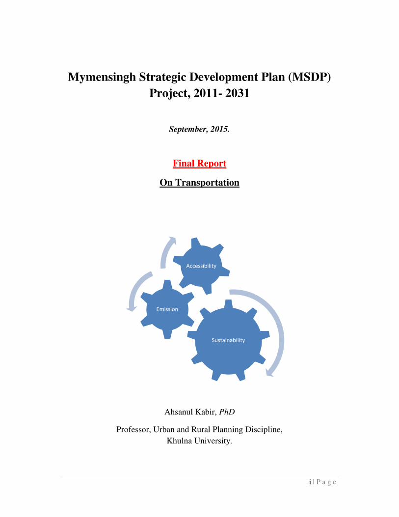
Sustainability
Emission
Accessibility
ii | P a g e
Table of Contents
Page No.
Introduction .......................................................................................................................... 1
Background ....................................................................................................................... 1
Objective ........................................................................................................................... 2
Assigned Task ................................................................................................................... 2
Scope of the work .............................................................................................................. 3
Methodology ......................................................................................................................... 4
Transport Data ................................................................................................................... 5
Household Survey ............................................................................................................. 5
Outline of Work Plan ......................................................................................................... 5
Travel and Transport in MSDP Area ..................................................................................... 7
Choice of Mode ................................................................................................................. 7
Road Network ................................................................................................................... 8
Road Coverage ................................................................................................................ 16
Public Transport .............................................................................................................. 16
Route ........................................................................................................................... 17
Network coverage ........................................................................................................ 17
Public Transport Operations ......................................................................................... 18
Travel Behavior .................................................................................................................. 21
Distance .......................................................................................................................... 21
Cost ................................................................................................................................. 22
Transport Related Proposals and Future Directions ............................................................. 24
Footpath Zone ................................................................................................................. 24
Fire Route and Road Widen ............................................................................................. 25
Bus Rapid Transit: ........................................................................................................... 28
Airport:............................................................................................................................ 29
Jetty: ................................................................................................................................ 30
Summary of Recommendation and Conclusion: .................................................................. 31
Recommendation ............................................................................................................. 31
Urban Form and Urban development ............................................................................... 31
New Roads, Connectivity and Improved Accessibility ..................................................... 34
iii | P a g e
Regional Road: ............................................................................................................ 35
Primary Road: .............................................................................................................. 36
Secondary Road: .......................................................................................................... 36
Local Road: ................................................................................................................. 37
Rail Road: .................................................................................................................... 38
Improving Public Transportation System ......................................................................... 38
Buildup Foot Path ............................................................................................................ 39
Identify fire route ............................................................................................................. 39
Road Widening ................................................................................................................ 39
Intersection Improvement ................................................................................................ 40
Conclusion ...................................................................................................................... 41
Appendix-A: House Hold Questionnaire ............................................................................... 1
Appendix-B: Name of Road Required to Widen (m.) ........................................................... 3
Appendix- C: Traffic Volumes at Intersections ...................................................................... 4
Appendix- D: Cross Section of Road with Footpath .............................................................. 7
List of Table
Table 1 MSDP Road Classification ....................................................................................... 9
Table 2 Type and Condition of local road of the Household ................................................ 15
Table 3 Average Cost/ week for Trip Purpose ..................................................................... 23
Table 4 Initiative Nave to take of mitigate Fire Hazard ........................................................ 26
List of Figure
Figure 1 Transport Modeling Component in MSDP .............................................................. 4
Figure 2 An Outline of Transport Studies in the MSDP Area ................................................ 6
Figure 3 Choice of mode for total trip ................................................................................... 7
Figure 4 Choice of mode for different purpose ...................................................................... 8
Figure 5 MSDP Road Category ............................................................................................. 8
Figure 6 Road Classification Map ....................................................................................... 10
Figure 7 Road Density Map................................................................................................. 11
iv | P a g e
Figure 8 Building Density Map ........................................................................................... 12
Figure 9 Trip Density Map .................................................................................................. 13
Figure 10 Problem faced by the city dwellers ...................................................................... 15
Figure 11 Route Length of Different Public Transport Option in Mymensingh .................... 16
Figure 12 Public Transport Routes in Mymensingh ............................................................. 17
Figure 13 Public Transport Accessibility ............................................................................. 18
Figure 14 Schematic guideline for Stoppage location .......................................................... 20
Figure 15 Travel Distance from household to different places (ft) ....................................... 22
Figure 16: Proposed Footpath Network in Mymensingh City .............................................. 25
Figure 17 Vulnerable Katcha House Outside Fire Brigade Coverage ................................... 26
Figure 18 Vulnerable Katcha Houses Beyond Fire Brigade Hosepipe Coverage .................. 27
Figure 19 Percentage of Road Width Greater than 14.5 ft .................................................... 27
Figure 20: Proposed Bus Rapid Transit ............................................................................... 28
Figure 21: Proposal ............................................................................................................. 30
Figure 22: Growth Centers Outside Existing City ................................................................ 32
Figure 23: Proposed Road Network in MSDP Area ............................................................. 35
Figure 24: Cross Section of Regional Road ......................................................................... 36
Figure 25: Cross Section of Primary Road: .......................................................................... 36
Figure 26: Cross Section of Secondary Road ....................................................................... 37
Figure 27: Cross Section of Local Road: ............................................................................. 37
Figure 28: Cross Section of Rail Road: ................................................................................ 38
Figure 29: Intersection of Kristopur road, K B Ismail Road and Shomboganj Bridge Road . 40
Figure 30: Intersection of K B Ismail Road and Dhaka-Mymensingh Highway ................... 41
Figure 31 Bridge Intersection ................................................................................................ 4
Figure 32 Gangnir Intersection .............................................................................................. 5
Figure 33 Townhall Intersection ............................................................................................ 5
Figure 34 Kawatkhali Bypass Intersection ............................................................................. 6
Figure 35 Cross Section of Road with Footpath ..................................................................... 7
Figure 36 Design of Road with Footpath ............................................................................... 7
1 | P a g e
Introduction Background
Bangladesh is one of the most climatic vulnerable countries in the world and the impact of
climate change is being appeared very clearly. Floods, tropical cyclones, earth quack, storm
surges and droughts are likely to become more frequent and severe in the coming years.
These changes would be threatened for the significant achievements of Bangladesh which has
been made over the last 20 years in increasing incomes and reducing poverty.
Realizing these problems a paradigm has been shifted in disaster management from its
conventional response and relief management approach to a more comprehensive risk
reduction culture. The Government of Bangladesh along with its development partners
designed and implemented the Comprehensive Disaster Management Programme (CDMP)
Phase-I during 2003-2009. On the basis of deriving actions of CDMP-I such as achievements,
lessons learned, utilizing knowledge resources generated and knowledge products published,
a vertical and horizontal expansion of the Phase-I has been designed which is known CDMP-
II (2010-2014). The overall goal of CDMP-II is to further reduce country's vulnerability to
adverse natural and anthropogenic events – including cyclones, hurricanes, floods, tidal
surges, earthquakes, tsunamis, climate change and variability, avian flu, fire, toxic
chemical/gas/pollutant leaks – through technical assistance in risk reduction and
comprehensive disaster management activities. The main approach of CDMP-II is to channel
support through government and development partners, civil society and NGOs into a people-
oriented disaster management and risk reduction partnership and allocate resources to disaster
management activities, risk reduction activities and climate change adaptation activities in
Bangladesh.
CDMP II offers an outstanding opportunity to improve linkages with, and collaborations
between national and the general stakeholder level for disaster risk reduction and adaptation
to climate change. The linkages are clearly expressed in many of the activities outlined in the
operational outcomes of the project design, as well as through strengthened institutional
capacities. Under this opportunity, a Memorandum of Understanding (MoU) delineated the
area of collaboration on 21th march, 2011 between CDMP-II and Urban Development
Directorate (UDD). A pilot project on comprehensive Land Use development planning and
2 | P a g e
management for Mymensingh (Municipality) Strategic Development Planning (MSDP) Area
for twenty years (2011-2031) time-span has been formed for preparing a module between
CDMP-II and Urban Development Directorate (UDD) for mainstreaming disaster risk
preventive measures.(Mymensingh Strategic Development Plan (MSDP) Project, 2011.
Available from: <http://msdp.gov.bd/index.php> [06 July. 2014]).
Objective
MSDP project aims to develop a sustainable development plan for the study area ensuring to
accommodate future growth in a sustainable manner. Among the various components of
development plan, transportation planning is very crucial in developing a sustainable and
climatic adoptive city. The main purpose of this exercise is to aid the MSDP projects in its
transport component in making/ designing a city.
Assigned Task
Major tasks as mentioned in the ToR are:
(i) to analyse the surveyed traffic volume, O-D and trip generation study data etc. and
identify the existing pattern of traffic for the project area;
(ii) to analyze transportation existing network of the project area;
(iii) to propose a future transportation network to establish an efficient inter and intra
town circulation system and also to establish rural-urban linkage for the project
area;
(iv) to develop traffic prediction model of the next 20-year period for the project area
by using latest available transportation related software.
(v) to work with a multidisciplinary team to integrate the output of the traffic surveys
and transportation studies with both attribute and spatial data of other different
components of the project;
(vi) to provide transportation related detailed design and drawing (nodal point, lane,
turning radius, L-Section and X-section and related infrastructure design, material
of the road and footpath etc.);

3 | P a g e
(vii) preparation of working paper, analytical report based on the studies and surveys.
Scope of the work
Within the outcome of MSDP, risk reduction is a potential thematic area that comprise of
reducing risk for urban and rural populations through structural and non-structural
interventions. This project has been given emphasis on initiatives those are comprises with
disaster preparedness interventions. These initiatives mainly addresses future transportation
network to establish an efficient inter and intra town circulation system and also to establish
rural urban linkage. Apart from this, project wants to develop traffic prediction model of the
next twenty year period. Furthermore, finally this MSDP project provides transport related
detail design and drawing and suggest about evacuation route for contingency plan.
4 | P a g e
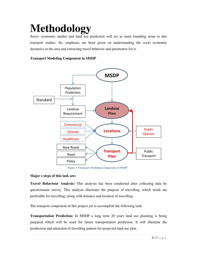
Methodology Socio- economic studies and land use prediction will act as main founding stone to this
transport studies. So, emphases are been given on understanding the socio economic
dynamics in the area and extracting travel behavior and parameters for it.
Transport Modeling Component in MSDP
Major s steps of this task are:
Travel Behaviour Analysis: This analysis has been conducted after collecting data by
questionnaire survey. This analysis illustrates the purpose of travelling, which mode are
preferable for travelling; along with distance and location of travelling.
The transport component of this project yet to accomplish the following task:
Transportation Prediction: In MSDP a long term 20 years land use planning is being
prepared which will be used for future transportation prediction. It will illustrate the
production and attraction of travelling pattern for projected land use plan.
Policy
MSDP
Landuse
Plan
Transport
Plan
Standard
Landuse
Requirement
Population
Prediction
New Roads
Road
Public
Opinion Locations
Commercial
Schools
HealthCare
Public
Transport
Figure 1 Transport Modeling Component in MSDP
5 | P a g e
Transport Network Analysis: A Network analysis will be conducted to know about future
travelling pattern such as in where congestion will be concentrated, what travelling
behavioral problems will be emerged, what types of interventions have to provide to
overcome these.
Critical Infrastructure and area identification: After Network analysis this study will
explore future congestion points, bottleneck of intervention, which roads have to be widened,
where have to provide foot path etc.
Proposed intervention: After identifying the bottlenecks there will be provided various
interventions to overcome these impediments which will create a sustainable transportation
system for Mymensingh.
Transport Data
Data collection team of the project provided socio economic data of urban and rural area
which also contains various transport related data. This data is provided into *.sav format
which contains respondents purpose of travelling, mode of travelling, problem they faced and
other data of tenement. GIS data of existing road network, building footprint, land-use and
other relevant data were also provided.
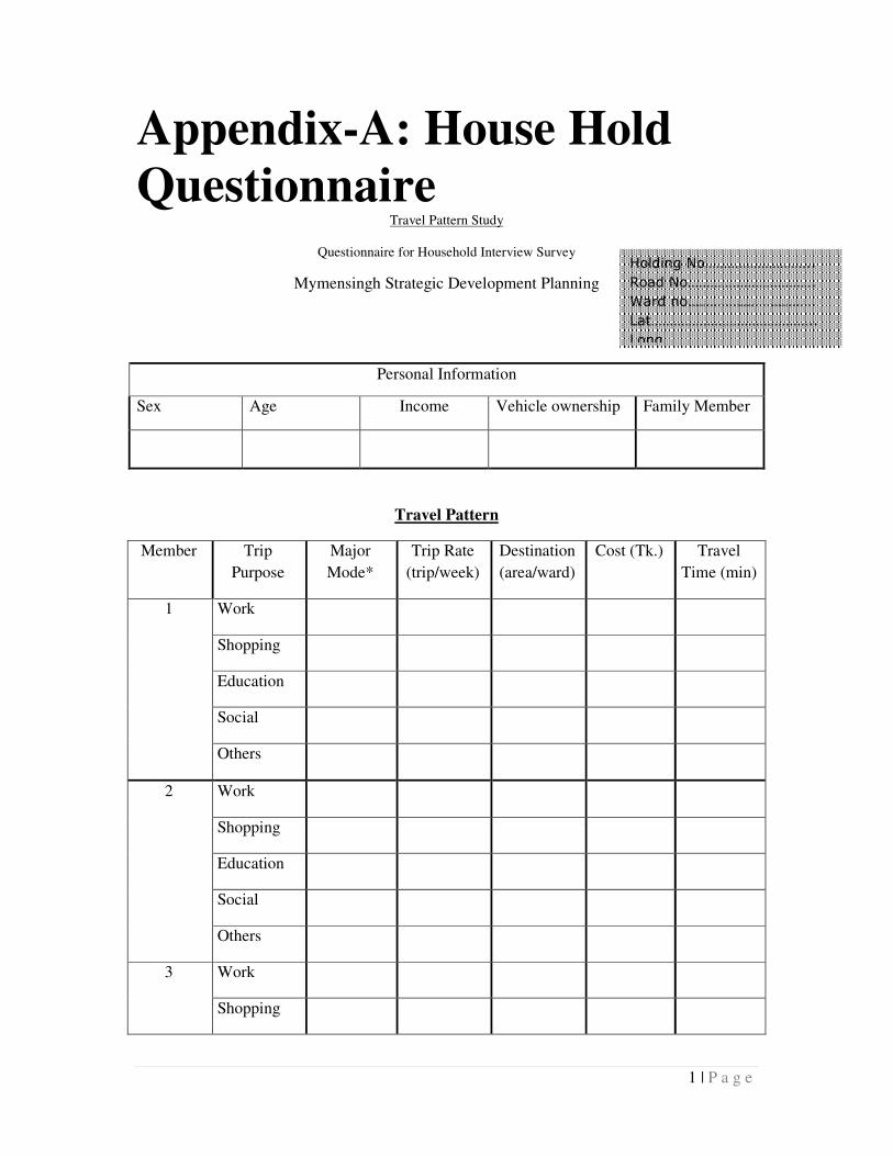
Household Survey
Household surveys were conducted to gather respondents’ travel behavior related
information. For this a semi-structured questionnaire (Appendix-A) were prepared which
consists of the questions about their purpose of trip, used mode, trip rate, destination, cost,
travel time. SPSS data base was developed with the mentioned variable for further analysis.
Outline of Work Plan
The transport study explores the travel behaviors and investigates the transportation system to
identify the bottle neck towards a sustainable transportation system. Travel behavior helps to
identify the trip rate and to estimate future trips. Road network along with these travel pattern
identifies overall movement of traffic and helps to pin-point the roads and areas that require
geometric intervention for capacity improvement.
6 | P a g e
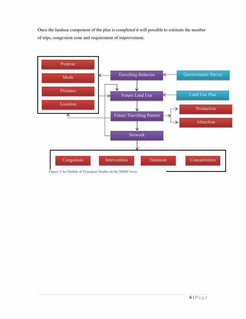
Once the landuse component of the plan is completed it will possible to estimate the number
of trips, congestion zone and requirement of improvement.
Travelling Behavior Questionnaire Survey
Future Land Use
Network
Future Travelling Pattern
Attraction
Production
Purpose
Mode
Distance
Location
Land Use Plan
Congestion Intervention Emission Concentration
Figure 2 An Outline of Transport Studies in the MSDP Area
7 | P a g e
29%
3%30%
1%
26%
0%3% 3% 1% 3%
1%
Mode choice of total trip
Walking
Bus
Easy Bike
Taxi
Rickshaw
Van
Bycycle
Motor Cycle
Car
Travel and Transport in
MSDP Area
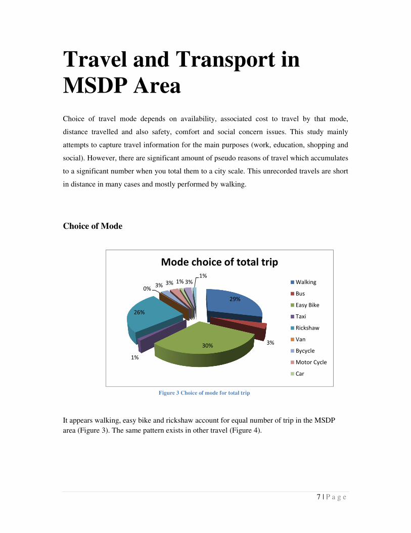
Choice of travel mode depends on availability, associated cost to travel by that mode,
distance travelled and also safety, comfort and social concern issues. This study mainly
attempts to capture travel information for the main purposes (work, education, shopping and
social). However, there are significant amount of pseudo reasons of travel which accumulates
to a significant number when you total them to a city scale. This unrecorded travels are short
in distance in many cases and mostly performed by walking.
Choice of Mode
It appears walking, easy bike and rickshaw account for equal number of trip in the MSDP
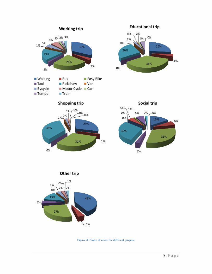
area (Figure 3). The same pattern exists in other travel (Figure 4).
Figure 3 Choice of mode for total trip
8 | P a g e
Figure 4 Choice of mode for different purpose
32%
3%
26%
2%
19%
1%5%
6%1% 2% 3%
Working trip
Walking Bus Easy Bike
Taxi Rickshaw Van
Bycycle Motor Cycle Car
Tempo Train
26%
4%36%
0%
26%
0%
2%
0% 2%
4% 0%
Educational trip
29%
1%31%
0%
35%
1%2%
1% 0%0%
0%
Shopping trip
16%6%
31%
3%
30%
0%
0%
5% 1%
6% 2% 0%
Social trip
42%
5%
27%
5%
13%
0%
3%2%
0%1%
2%
Other trip
8 | P a g e
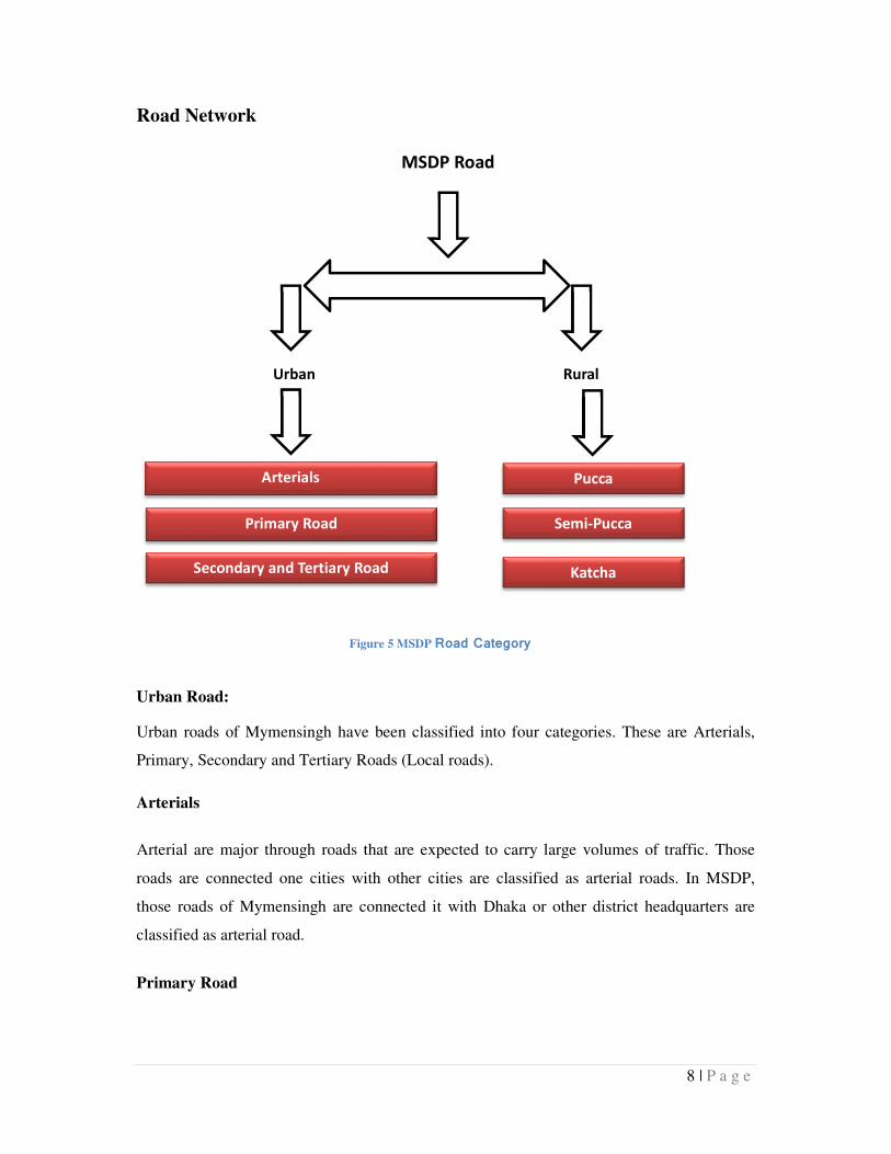
Road Network
Urban Road:
Urban roads of Mymensingh have been classified into four categories. These are Arterials,
Primary, Secondary and Tertiary Roads (Local roads).
Arterials
Arterial are major through roads that are expected to carry large volumes of traffic. Those
roads are connected one cities with other cities are classified as arterial roads. In MSDP,
those roads of Mymensingh are connected it with Dhaka or other district headquarters are
classified as arterial road.
Primary Road
MSDP Road
Classification
Urban
Road
Arterials
Rural
Road
Pucca
Primary Road
Secondary and Tertiary Road
Semi-Pucca
Katcha
Figure 5 MSDP Road Category
9 | P a g e
Collector road collect traffic from local roads, and distribute it to arterials. Traffic using a
collector is usually going to or coming from somewhere nearby.
Secondary and Tertiary Road (Local roads)
At the bottom of the hierarchy are local streets and roads. These roads have the lowest speed
limit, and carry low volumes of traffic. This road ensures existing road network within the
city. Those roads consist more than 15ft width are classified as secondary road and else are
denoted as Tertiary road.
Rural Road:
Rural roads are classified on the basis of its pavement whether it is paved or unpaved. These
roads are classified into three categories; these are Pucca, Semi-Pucca and Katcha.
Table 1 MSDP Road Classification
MSDP Road Classification Class Length (Km.)
Urban Road Arterial Road 7.34
Primary Road 16.10
Secondary and Tertiary Road
(Local Roads)
68.14
Rural Road Pucca 248.47
Semi-Pucca 22.20
Katcha 676.52
Unknown .06
10 | P a g e
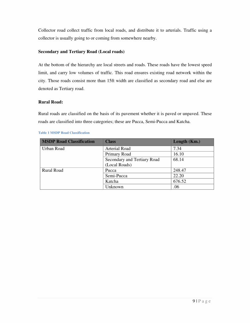
Road Classification Map
Figure 6 Road Classification Map
11 | P a g e
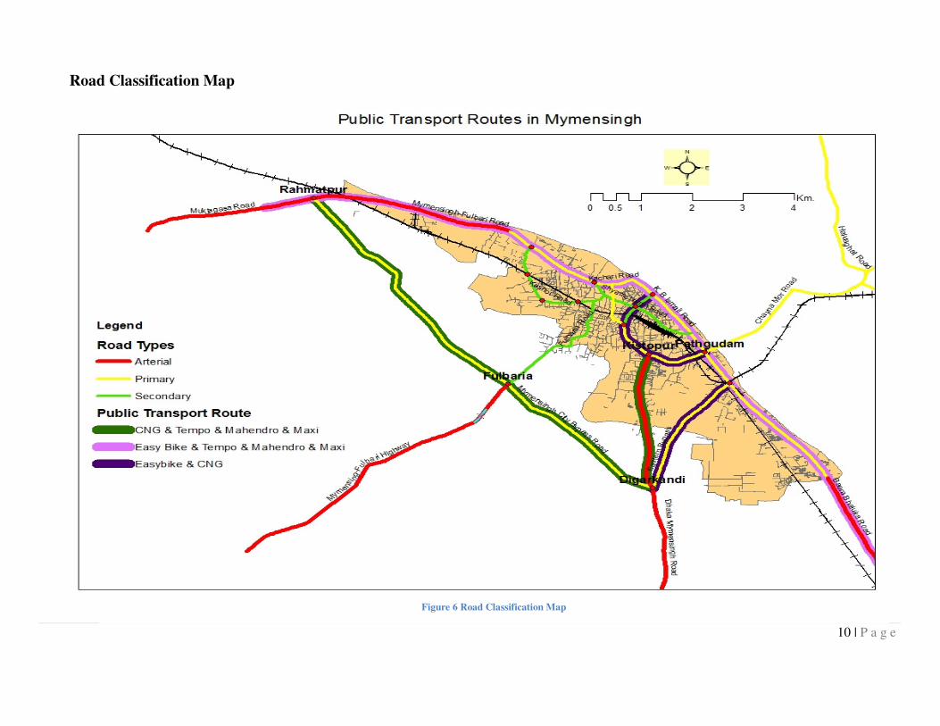
Road Density
Figure 7 Road Density Map
12 | P a g e
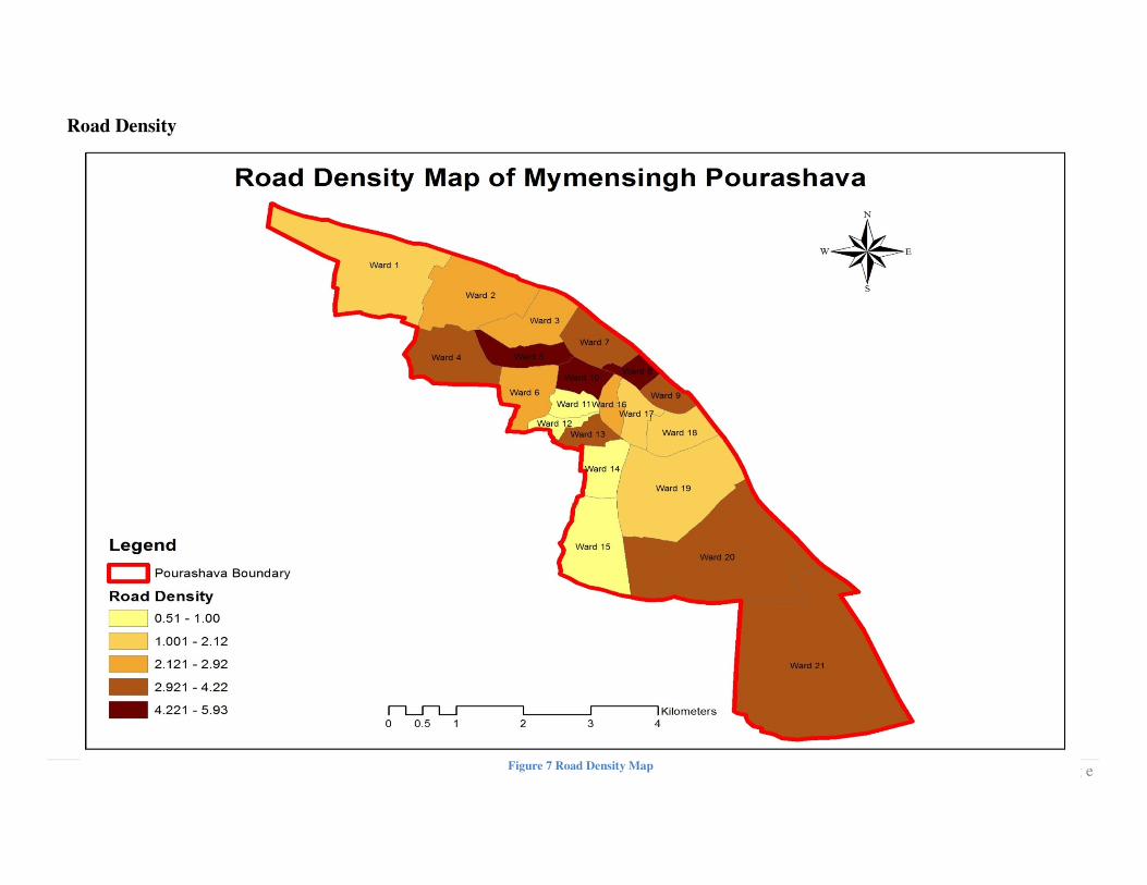
Building Density
Figure 8 Building Density Map
13 | P a g e
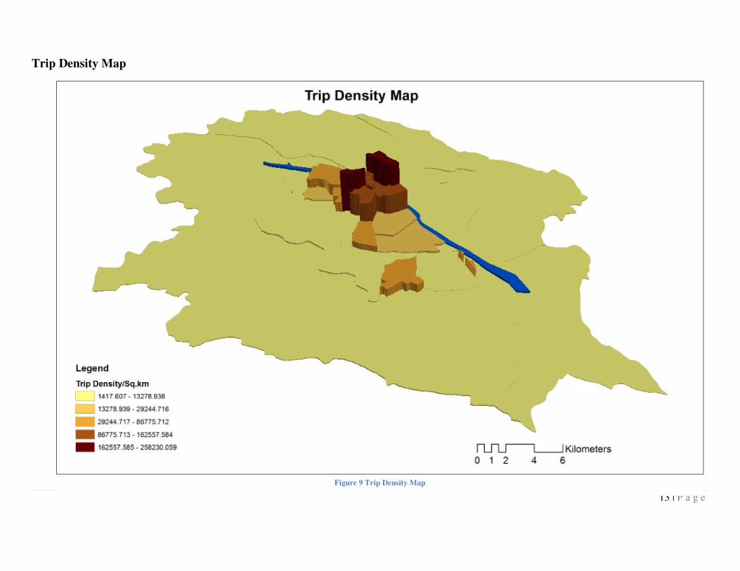
Trip Density Map
Figure 9 Trip Density Map
15 | P a g e
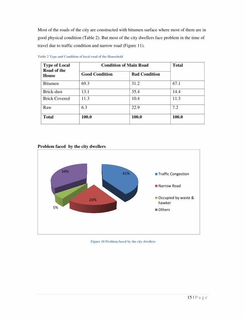
Most of the roads of the city are constructed with bitumen surface where most of them are in
good physical condition (Table 2). But most of the city dwellers face problem in the time of
travel due to traffic condition and narrow road (Figure 11).
Table 2 Type and Condition of local road of the Household
Type of Local
Road of the
House
Condition of Main Road Total
Good Condition Bad Condition
Bitumen 69.3 31.2 67.1
Brick-dust 13.1 35.4 14.4
Brick Covered 11.3 10.4 11.3
Raw 6.3 22.9 7.2
Total 100.0 100.0 100.0
Problem faced by the city dwellers
Figure 10 Problem faced by the city dwellers
41%
20%
5%
34%Traffic Congestion
Narrow Road
Occupied by waste &
hawker
Others
16 | P a g e
Road Coverage
Access is not an issue for the Mymensingh city (figure 8). Road density is high in the ward
no 5, 8 and 11 which consist the main city and its business centre. However, their geometric
is not suitable for the traffic volume it carries. It shows nearly 80% roads are below 4 meter
which is the minimum requirement for any fire and rescue vehicle.
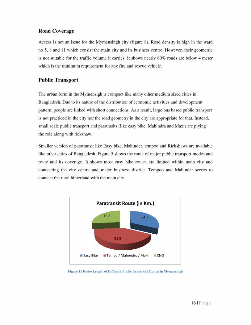
Public Transport
The urban form in the Mymensigh is compact like many other medium sized cities in
Bangladesh. Due to its nature of the distribution of economic activities and development
pattern, people are linked with short connections. As a result, large bus based public transport
is not practiced in the city nor the road geometry in the city are appropriate for that. Instead,
small scale public transport and paratrasits (like easy bike, Mahindra and Maxi) are plying
the role along with rickshaw.
Smaller version of paratransit like Easy bike, Mahinder, tempoo and Rickshaws are available
like other cities of Bangladesh. Figure 5 shows the route of major public transport modes and
route and its coverage. It shows most easy bike routes are limited within main city and
connecting the city centre and major business district. Tempoo and Mahindar serves to
connect the rural hinterland with the main city.
Figure 11 Route Length of Different Public Transport Option in Mymensingh
24.2
31.5
19.8
Paratransit Route (in Km.)
Easy Bike Tempo / Mahendro / Maxi CNG
17 | P a g e
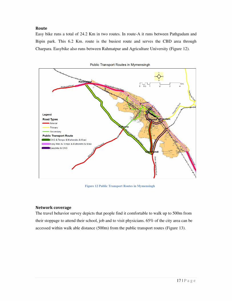
Route
Easy bike runs a total of 24.2 Km in two routes. In route-A it runs between Pathgudam and
Bipin park. This 6.2 Km. route is the busiest route and serves the CBD area through
Charpara. Easybike also runs between Rahmatpur and Agriculture University (Figure 12).
Network coverage
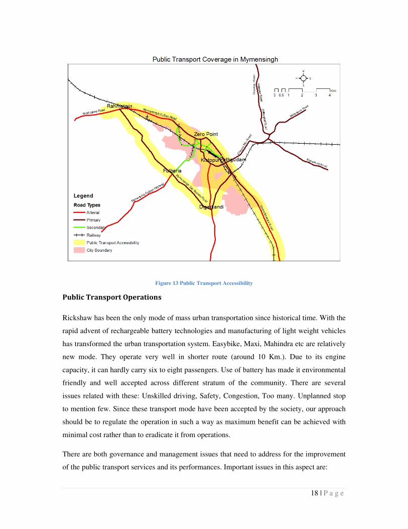
The travel behavior survey depicts that people find it comfortable to walk up to 500m from
their stoppage to attend their school, job and to visit physicians. 65% of the city area can be
accessed within walk able distance (500m) from the public transport routes (Figure 13).
Figure 12 Public Transport Routes in Mymensingh
18 | P a g e
Figure 13 Public Transport Accessibility
Public Transport Operations
Rickshaw has been the only mode of mass urban transportation since historical time. With the
rapid advent of rechargeable battery technologies and manufacturing of light weight vehicles
has transformed the urban transportation system. Easybike, Maxi, Mahindra etc are relatively
new mode. They operate very well in shorter route (around 10 Km.). Due to its engine
capacity, it can hardly carry six to eight passengers. Use of battery has made it environmental
friendly and well accepted across different stratum of the community. There are several
issues related with these: Unskilled driving, Safety, Congestion, Too many. Unplanned stop
to mention few. Since these transport mode have been accepted by the society, our approach
should be to regulate the operation in such a way as maximum benefit can be achieved with
minimal cost rather than to eradicate it from operations.
There are both governance and management issues that need to address for the improvement
of the public transport services and its performances. Important issues in this aspect are:
19 | P a g e
• Public transport governance. All motorized vehicle licenses are controlled by the
Bangladesh Road Transport Authority (BRTA) and rickshaws are in general by the
city corporation or municipalities. In term of easy bike and mahindar our regulatory
institutes are yet to finalize their policy and control mechanism. Certain number of
easy bikes are licensed by the Mymensigh city corporation and in reality the number
of vehicles operating are manifolds. So, it should be first stage to decide its
governance issue. Who will control the licensing and hence number, who will take
care their fitness and policing their driving behavior. There should be provision and
practice to apply fines (with impact on license) to all for violating prevailing rules.
• Driving license. Public transport drivers require advanced training or requirement as
they have greater responsibilities on public safety. But it is found that most small
public transport or paratransit drivers do not have driving licensing nor any training.
As a result they are causing accident and congestion in road.
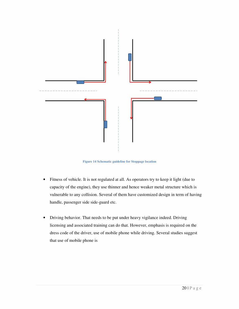
• Stoppage. As most paratransit operates, there is no fixed stoppage for the easybike.
However there are few key locations for each of the routes. Along the whole city,
stoppage location can be determined (connecting points to job and schools) and
guideline can be developed for the public transport. In figure 14 a schematic guideline
for stop locations are illustrated.
20 | P a g e
Figure 14 Schematic guideline for Stoppage location
• Fitness of vehicle. It is not regulated at all. As operators try to keep it light (due to
capacity of the engine), they use thinner and hence weaker metal structure which is
vulnerable to any collision. Several of them have customized design in term of having
handle, passenger side side-guard etc.
• Driving behavior. That needs to be put under heavy vigilance indeed. Driving
licensing and associated training can do that. However, emphasis is required on the
dress code of the driver, use of mobile phone while driving. Several studies suggest
that use of mobile phone is
21 | P a g e
Travel Behavior
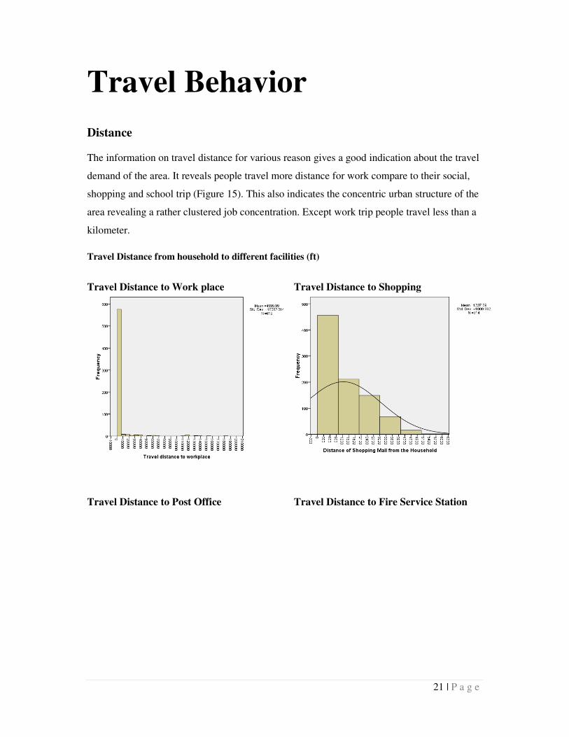
Distance
The information on travel distance for various reason gives a good indication about the travel
demand of the area. It reveals people travel more distance for work compare to their social,
shopping and school trip (Figure 15). This also indicates the concentric urban structure of the
area revealing a rather clustered job concentration. Except work trip people travel less than a
kilometer.
Travel Distance from household to different facilities (ft)
Travel Distance to Work place
Travel Distance to Shopping
Travel Distance to Post Office
Travel Distance to Fire Service Station
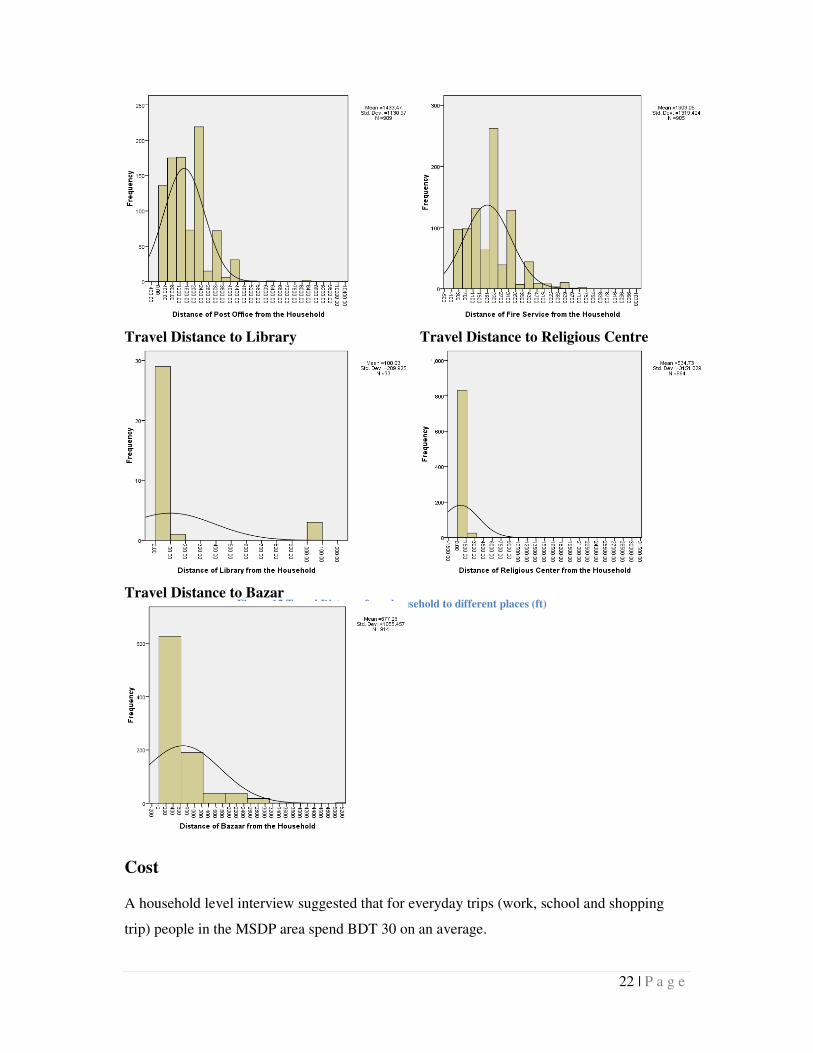
22 | P a g e
Cost
A household level interview suggested that for everyday trips (work, school and shopping
trip) people in the MSDP area spend BDT 30 on an average.
Travel Distance to Library
Travel Distance to Religious Centre
Travel Distance to Bazar
Figure 15 Travel Distance from household to different places (ft)
23 | P a g e
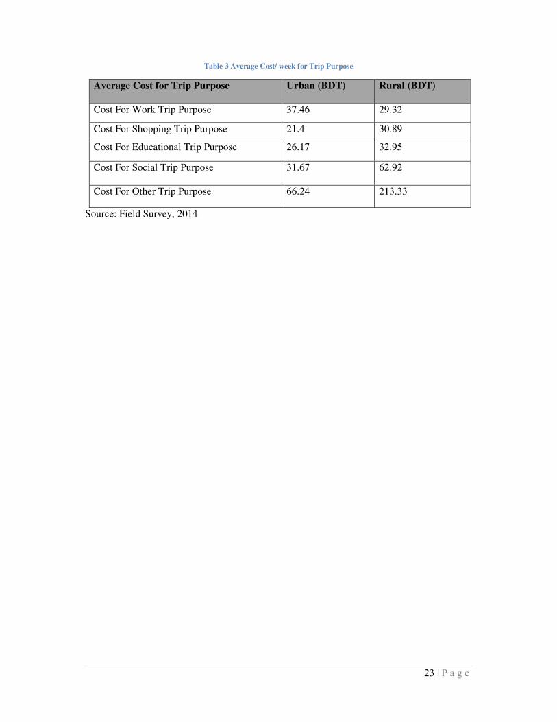
Table 3 Average Cost/ week for Trip Purpose
Average Cost for Trip Purpose Urban (BDT) Rural (BDT)
Cost For Work Trip Purpose 37.46 29.32
Cost For Shopping Trip Purpose 21.4 30.89
Cost For Educational Trip Purpose 26.17 32.95
Cost For Social Trip Purpose 31.67 62.92
Cost For Other Trip Purpose 66.24 213.33
Source: Field Survey, 2014
24 | P a g e
Transport Related Proposals
and Future Directions Footpath Zone
More than one third of the total trips are performed by walking, which is a good indicator to
ensure sustainability for transportation and for the city. This also indicates the compact nature
of the development. The travel pattern information also suggests a lower travel distance for
everyday job, school and shopping. People can easily performed that by walking. However,
we do not see much option for footpath in the area. This study suggest a network of footpath
that can connect the public transport stoppage with the important activities such as
commercial centers, schools, hospital etc.
Among many roads such as B K Ismail Road, Kristopur Road, C.K Ghosh Road ,
Durgabari Road, Kali Sangkar Ghoh Road, Ram Babu Road, Sarda Ghosh Road are on CBD
area and some schools are situated beside these roads that have 22ft to 26ft width. Many
School children use JC Guha Road and Shyamchoron Road, which have 32ft to 40ft width,
owing to their location.
Generally for mixed traffic, 21ft is required for an effective road design excluding footpath.
On the either side of the carriage way, footpath is recommended for those roads that serves
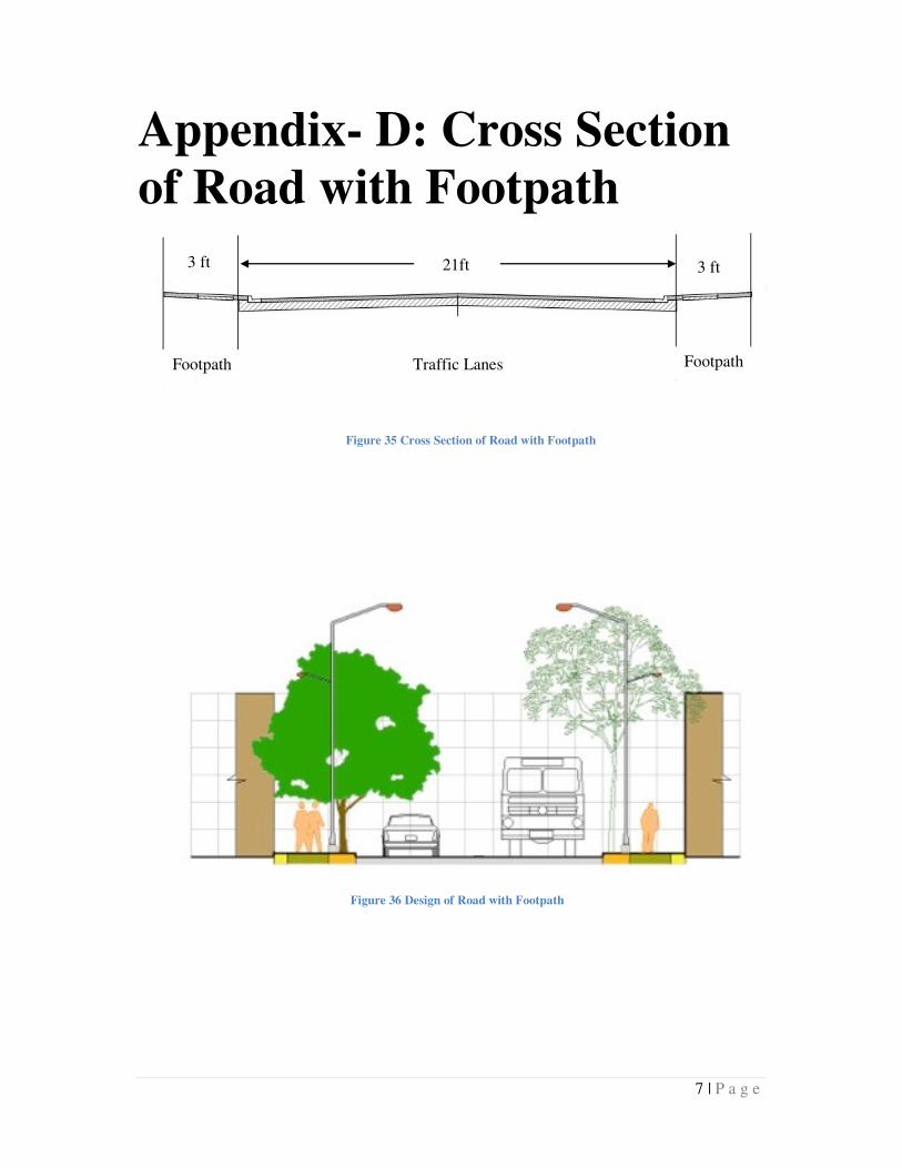
activities situated in CBD area and schools. For footpath, 3 feet width for each side may be
convenient for the pedestrian. Here a cross section of road and design is provided
(Appendix-C). For JC Guha Road and Shyamchoron Road traffic lanes can be 24ft and each
footpath will be 4ft.
25 | P a g e
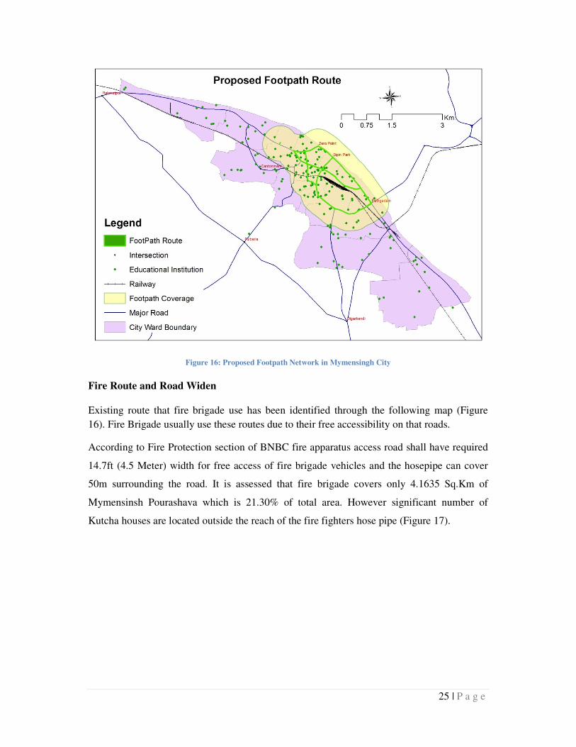
Figure 16: Proposed Footpath Network in Mymensingh City
Fire Route and Road Widen
Existing route that fire brigade use has been identified through the following map (Figure
16). Fire Brigade usually use these routes due to their free accessibility on that roads.
According to Fire Protection section of BNBC fire apparatus access road shall have required
14.7ft (4.5 Meter) width for free access of fire brigade vehicles and the hosepipe can cover
50m surrounding the road. It is assessed that fire brigade covers only 4.1635 Sq.Km of
Mymensinsh Pourashava which is 21.30% of total area. However significant number of
Kutcha houses are located outside the reach of the fire fighters hose pipe (Figure 17).
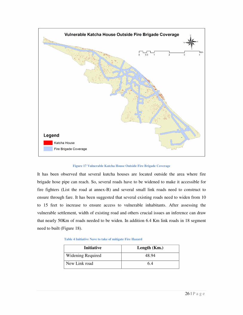
26 | P a g e
Figure 17 Vulnerable Katcha House Outside Fire Brigade Coverage
It has been observed that several kutcha houses are located outside the area where fire
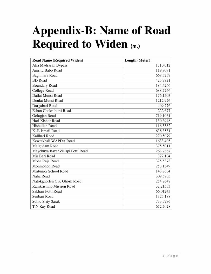
brigade hose pipe can reach. So, several roads have to be widened to make it accessible for
fire fighters (List the road at annex-B) and several small link roads need to construct to
ensure through fare. It has been suggested that several existing roads need to widen from 10
to 15 feet to increase to ensure access to vulnerable inhabitants. After assessing the
vulnerable settlement, width of existing road and others crucial issues an inference can draw
that nearly 50Km of roads needed to be widen. In addition 6.4 Km link roads in 18 segment
need to built (Figure 18).
Table 4 Initiative Nave to take of mitigate Fire Hazard
Initiative Length (Km.)
Widening Required 48.94
New Link road 6.4
27 | P a g e
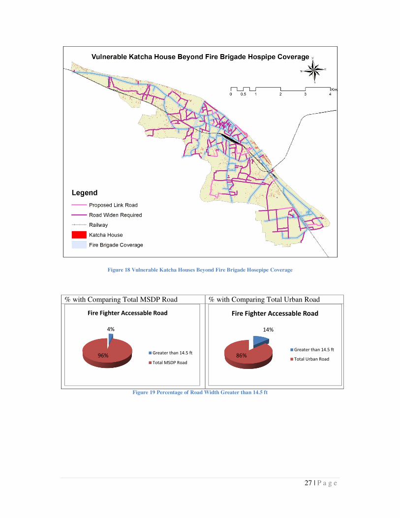
Figure 18 Vulnerable Katcha Houses Beyond Fire Brigade Hosepipe Coverage
% with Comparing Total MSDP Road % with Comparing Total Urban Road
Figure 19 Percentage of Road Width Greater than 14.5 ft
4%
96%
Fire Fighter Accessable Road
Greater than 14.5 ft
Total MSDP Road
14%
86%
Fire Fighter Accessable Road
Greater than 14.5 ft
Total Urban Road
28 | P a g e
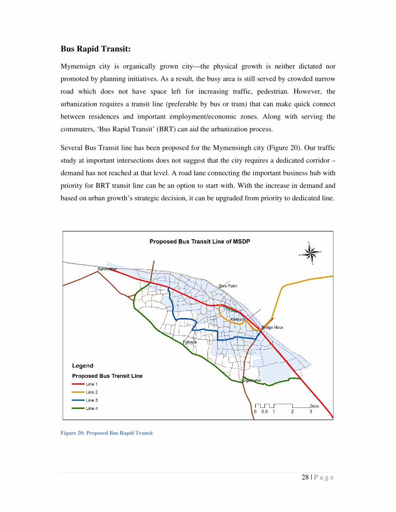
Bus Rapid Transit:
Mymensign city is organically grown city—the physical growth is neither dictated nor
promoted by planning initiatives. As a result, the busy area is still served by crowded narrow
road which does not have space left for increasing traffic, pedestrian. However, the
urbanization requires a transit line (preferable by bus or tram) that can make quick connect
between residences and important employment/economic zones. Along with serving the
commuters, ‘Bus Rapid Transit’ (BRT) can aid the urbanization process.
Several Bus Transit line has been proposed for the Mymensingh city (Figure 20). Our traffic
study at important intersections does not suggest that the city requires a dedicated corridor –
demand has not reached at that level. A road lane connecting the important business hub with
priority for BRT transit line can be an option to start with. With the increase in demand and
based on urban growth’s strategic decision, it can be upgraded from priority to dedicated line.
Figure 20: Proposed Bus Rapid Transit
29 | P a g e
• Line 1: this line is proposed along the current rail corridor. On the either side of the
rail line, around 20 meter service road or left over space is available. This can be
utilized.
• Line 2: is an extension of line 2 to business hub Shomvuganj bazar. This line will be
critically essential if and when the proposed Industrial area north to the Shomvuganj
bazar will be developed. It will be a hub for manufacturing job and requires a quick
connection with the existing city and its neighboring suburbs. The proposed
alignment has 20 ROW and can easily accommodate a priority lane for BRT.
• Line 3: It is a proposed loop – inner ring for BRT. Implementing this will help in
withdrawing congestion from present city center to the outer ring. By providing this
BRT service, new economic activities will be emerged in the areas enclosed by line 1
and line 3. At the same time, it will boost up the local real estate and building industry
which has many spin-off for local economy and employment.
The proposed alignment is tentative. Depending on the feasibility of land acquisition
it can be smoothen. In the proposed line, there are segments with 12 meter ROW. For
these, (comparatively) narrow lane, road side acquisition may require. This alignment
is currently of low density. So, acquisition initiative can be taken before the rapid
growth takes place.
• Line 4: Outer ring. This can be implemented in long run. However it will be effective
once the city is expanded up to the outer ring.
Role of BRT in urban sustainability is nothing to establish. But to make it an urban
management agent, requires strong implementation of urban governance and growth control.
Airport:
A domestic airport has been suggested at Rahmatpur (North-West of Mymensign City)
(Figure 21, Circle 1). Being close to Dhaka a complete airport won’t be feasible in
Mymensingh. However, it’s an option to facilitate in emergency situation.
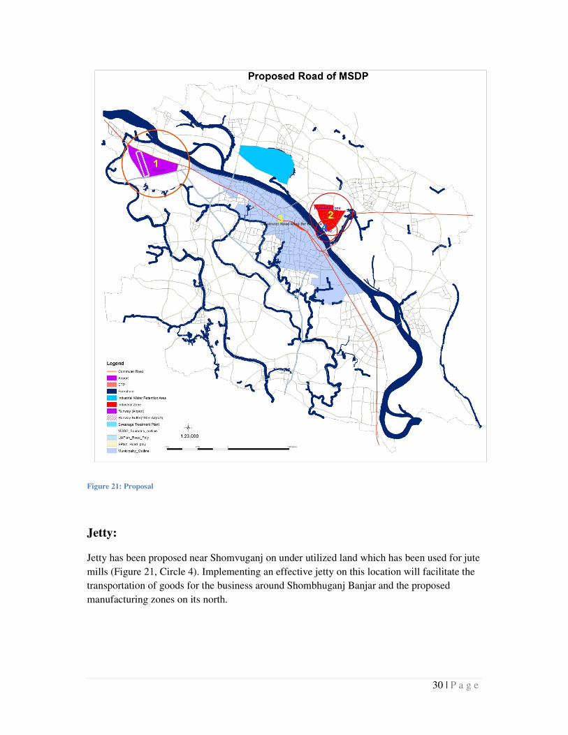
30 | P a g e
Figure 21: Proposal
Jetty:
Jetty has been proposed near Shomvuganj on under utilized land which has been used for jute
mills (Figure 21, Circle 4). Implementing an effective jetty on this location will facilitate the
transportation of goods for the business around Shombhuganj Banjar and the proposed
manufacturing zones on its north.
31 | P a g e
Summary of
Recommendation and
Conclusion:
Recommendation
Urban Form and Urban development
The landuse, buildings and the street pattern suggests that settlements in the Mymensingh has
compact nature with mixed urban functions. These urban forms are appreciated to consider as
sustainable. Survey on travel behavior also support the assumption by revealing short travel
distance for commuting, schooling, shopping and everyday job. If appropriate transport
connections are made, walk ways are created, footpaths are ensured and city governances are
enforced, this city can accommodate its growth for coming days without much expanding
urban boundary (Mymensingh City Bypass Road) or without creating any satellite towns.
Several blocks of residential and commercial areas are underutilized due to access:
insufficient road width or no road at all. These blocks are proposed to connect the missing
links and provide sufficient width of the access/service roads to ensure mobility and flow of
traffic.
MSDP structure plan has proposed a hierarchy of road network which ensures accessibility
across the area. Effort has been given to complete the loop of the local urban road network
that ensures shortest mobility between two points in a neighborhood. At the same time it has
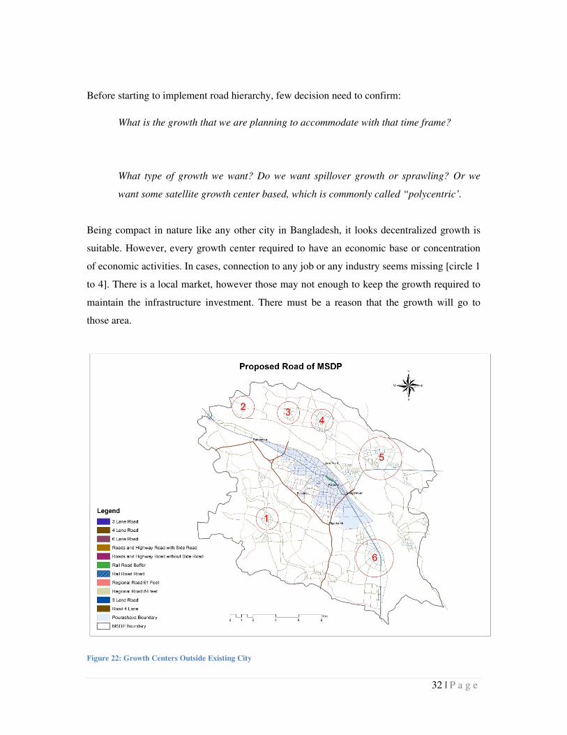
proposed to create several center for growth concentration (Figure 22).
Using road hierarchy, a system of block has been proposed. For currently developed city,
average block size is 500x500 meter. However, south to the Phulbari road, a low density
development is proposed with a regularly spaced road network. The proposed block size is
2x2km on the low density rural land.
32 | P a g e
Before starting to implement road hierarchy, few decision need to confirm:
What is the growth that we are planning to accommodate with that time frame?
What type of growth we want? Do we want spillover growth or sprawling? Or we
want some satellite growth center based, which is commonly called “polycentric’.
Being compact in nature like any other city in Bangladesh, it looks decentralized growth is
suitable. However, every growth center required to have an economic base or concentration
of economic activities. In cases, connection to any job or any industry seems missing [circle 1
to 4]. There is a local market, however those may not enough to keep the growth required to
maintain the infrastructure investment. There must be a reason that the growth will go to
those area.
Figure 22: Growth Centers Outside Existing City
33 | P a g e
Landuse intensity and proposed landuse plan need to be evaluated along with proposed road
hierarchy. In the proposed plan, it appears that several hubs has been created (Figure 22).
• [circle 1]. It looks a small hub/growth center has been created around an intersection.
Don’t know the reason or economic magnet for that. But looks it has market,
commercial and schools in that area. Investment in road infrastructure in that area will
enhance the local growth and might convert to a small center away from main town
and might serve as a satellite between Phulbari and Mymensingh.
• [circle 2]. This area already seems to have rural residential area and local market. It
will be difficult to attract growth to this area. This is merely a rural settlement with
concentration of commercial activities. To convert an area into a center we need to
convert them to a business or employment hub.
• [circle 3/4: Char Gobindopur]. It already has rural settlements and administrative
offices. It is not clear about the average plot size in those area but seems pity large.
Proposing a center will need an intervention like land readjustment. Also to make it
attractive for housing or business, some intervention is needed.
However, the growth of this area will largely depends on the proposed bridge. If a bridge can
be build at Taltola (as proposed in the structure plan), Char Gobindopur will thrive quickly.
• [circle 5: Shombuganj]. Shombugang is already a prominent center for business and
industries. Structure plan suggests expansion of this trade center towards north and
along the north side of the rail alignment. This proposed location need administrative
support to establish leather industries and trade center. Having adjoin rail line will
ensure movement of goods.
• [circle 5: Beltoli]. A larger area has been proposed for expansion for Beltoli. To make
it center it requires to have a good transport connection with Mymensingh city. Good
highway network (Mymensingh-Sutiakhali highway) is already there but good public
34 | P a g e
transport would encourage many people to live there and commute to main city or
other growth center.
Several missing links have been treated to complete the loop (inside Mymensingh City
bypass). This may require some land acquisition and participatory land readjustment. Area
between rail road and Mymensingh City bypass is characterized by low density residential
area (sardar para, vatikshor, aqua uttor para, maddha dakhin para, kewatkhali). The proposed
roads will increase the local accessibility of the area and potential for price hiking once the
plan is released. At the same time, if development can be controlled, this could be extension
of the city.
It appears that effort has been made to contain the urbanization within Mymensingh City
bypass. To accommodate growth, several center has been proposed for development and
good road network has been proposed. However success of this plan depends on the
governance of the implementation of the infrastructure specially the roads. To sustain those
decentralized centers, some administrative or economic activities may need to transfer to
those locations or incentives should be arranged as growth occurs or concentrates.
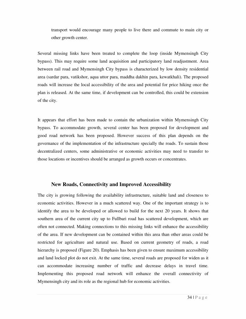
New Roads, Connectivity and Improved Accessibility
The city is growing following the availability infrastructure, suitable land and closeness to
economic activities. However in a much scattered way. One of the important strategy is to
identify the area to be developed or allowed to build for the next 20 years. It shows that
southern area of the current city up to Fullbari road has scattered development, which are
often not connected. Making connections to this missing links will enhance the accessibility
of the area. If new development can be contained within this area than other areas could be
restricted for agriculture and natural use. Based on current geometry of roads, a road
hierarchy is proposed (Figure 20). Emphasis has been given to ensure maximum accessibility
and land locked plot do not exit. At the same time, several roads are proposed for widen as it
can accommodate increasing number of traffic and decrease delays in travel time.
Implementing this proposed road network will enhance the overall connectivity of
Mymensingh city and its role as the regional hub for economic activities.
35 | P a g e
For future road classification several indicators were considered. Major considerations were
function of any particular road and types of vehicles that will ply on it. Width of different
vehicle has been collected from field survey
� Truck - 8 ft 4 inch
� Bus - 8 ft 3 inch
� Microbus - 5 ft 6 inch
� Car - 5 ft 5 inch
� Rickshaw - 3 ft 11 inch
Figure 23: Proposed Road Network in MSDP Area
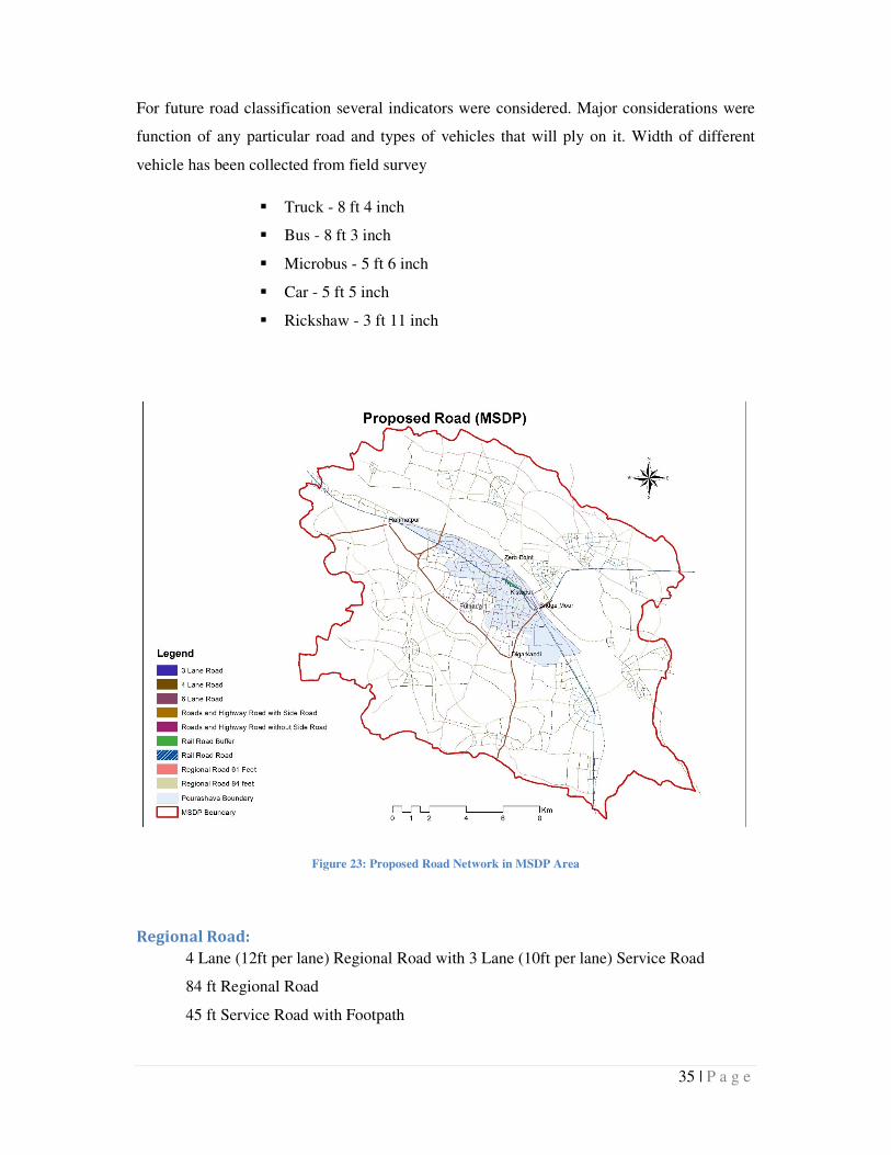
Regional Road:
4 Lane (12ft per lane) Regional Road with 3 Lane (10ft per lane) Service Road
84 ft Regional Road
45 ft Service Road with Footpath
36 | P a g e
Figure 24: Cross Section of Regional Road
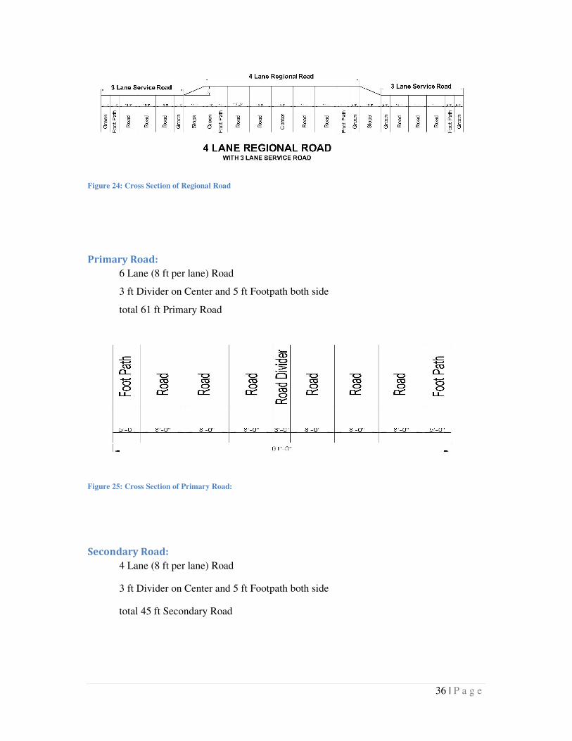
Primary Road:
6 Lane (8 ft per lane) Road
3 ft Divider on Center and 5 ft Footpath both side
total 61 ft Primary Road
Figure 25: Cross Section of Primary Road:
Secondary Road:
4 Lane (8 ft per lane) Road
3 ft Divider on Center and 5 ft Footpath both side
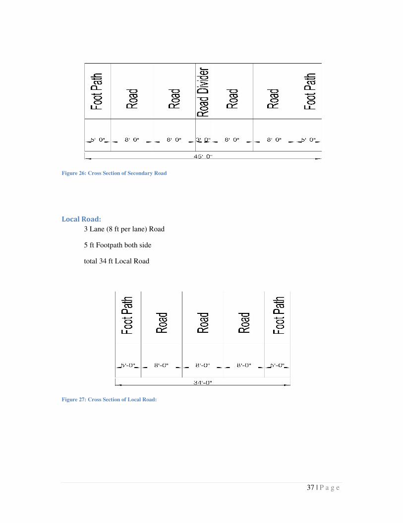
total 45 ft Secondary Road
37 | P a g e
Figure 26: Cross Section of Secondary Road
Local Road:
3 Lane (8 ft per lane) Road
5 ft Footpath both side
total 34 ft Local Road
Figure 27: Cross Section of Local Road:
38 | P a g e
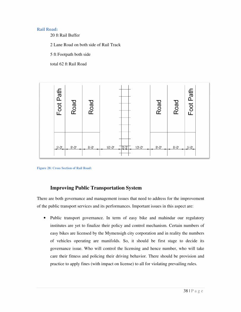
Rail Road:
20 ft Rail Buffer
2 Lane Road on both side of Rail Track
5 ft Footpath both side
total 62 ft Rail Road
Figure 28: Cross Section of Rail Road:
Improving Public Transportation System
There are both governance and management issues that need to address for the improvement
of the public transport services and its performances. Important issues in this aspect are:
• Public transport governance. In term of easy bike and mahindar our regulatory
institutes are yet to finalize their policy and control mechanism. Certain numbers of
easy bikes are licensed by the Mymensigh city corporation and in reality the numbers
of vehicles operating are manifolds. So, it should be first stage to decide its
governance issue. Who will control the licensing and hence number, who will take
care their fitness and policing their driving behavior. There should be provision and
practice to apply fines (with impact on license) to all for violating prevailing rules.
39 | P a g e
• Driving license. Public transport drivers require advanced training or requirement as
they have greater responsibilities on public safety. But it is found that most small
public transport or paratransit drivers do not have driving licensing nor any training.
As a result they are causing accident and congestion in road.
• Stoppage. As most paratransit operates, there is no fixed stoppage for the easybike.
However there are few key locations for each of the routes. Along the whole city,
stoppage location can be determined (connecting points to job and schools) and
guideline can be developed for the public transport. In figure 14 a schematic guideline
for stop locations are illustrated.
Buildup Foot Path
Generally for Traffic Lanes (10.5ftX2) total minimum 21ft is required for an effective road
design excluding footpath. Outside of the carriage way we can provide footpath of those
roads carry large amount people mainly situated in CBD area and beside schools. For
Footpath 3ft with for each side may be convenient for the pedestrian. Here a cross section of
road and design is provided (Appendix-c). For JC Guha Road and Shyamchoron Road traffic
lanes can be 24ft and each footpath can be 4ft.
Identify fire route
According to Fire Protection section of BNBC fire apparatus access road shall have required
14.7ft (4.5 Meter) width for free access of fire brigade vehicles and the hosepipe can cover
50m surrounding the road. It is assessed that fire brigade facilities covers only 4.1635 Sq.Km
of Mymensinsh Pourashava which is 21.30% of total area. However significant numbers of
Kutcha houses are located outside area in where it is difficult to reach the fire fighters hose
pipe (Figure 17). So, it is very much crucial for widening road width so that there have had
free access for fire brigade vehicles and the hosepipe can cover the whole area of
Mymensingh.
Road Widening
It has been suggested that several existing roads need to widen from 10 to 15 feet to increase
to ensure access to vulnerable inhabitants. After assessing the vulnerable settlement, width of
40 | P a g e
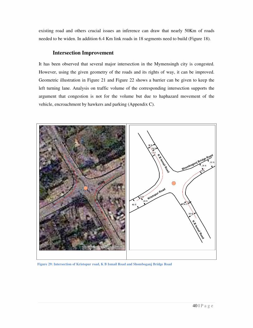
Figure 29: Intersection of Kristopur road, K B Ismail Road and Shomboganj Bridge Road
existing road and others crucial issues an inference can draw that nearly 50Km of roads
needed to be widen. In addition 6.4 Km link roads in 18 segments need to build (Figure 18).
Intersection Improvement
It has been observed that several major intersection in the Mymensingh city is congested.
However, using the given geometry of the roads and its rights of way, it can be improved.
Geometric illustration in Figure 21 and Figure 22 shows a barrier can be given to keep the
left turning lane. Analysis on traffic volume of the corresponding intersection supports the
argument that congestion is not for the volume but due to haphazard movement of the
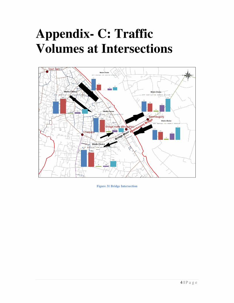
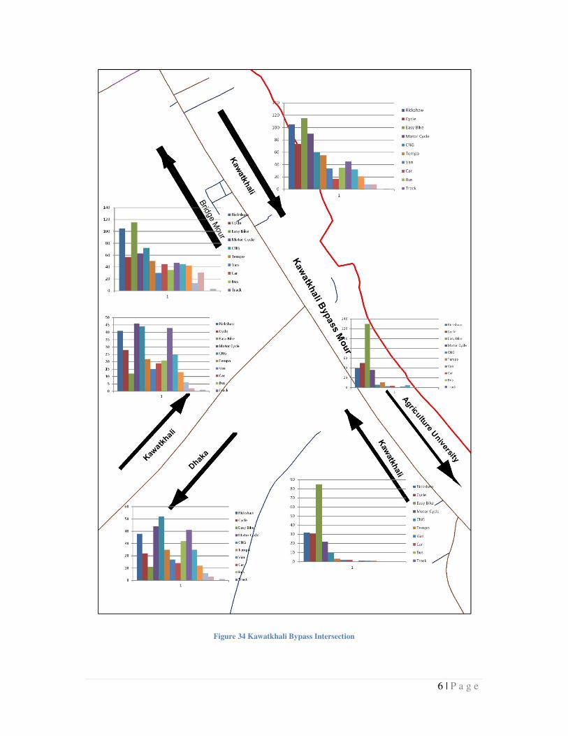
vehicle, encroachment by hawkers and parking (Appendix C).
41 | P a g e
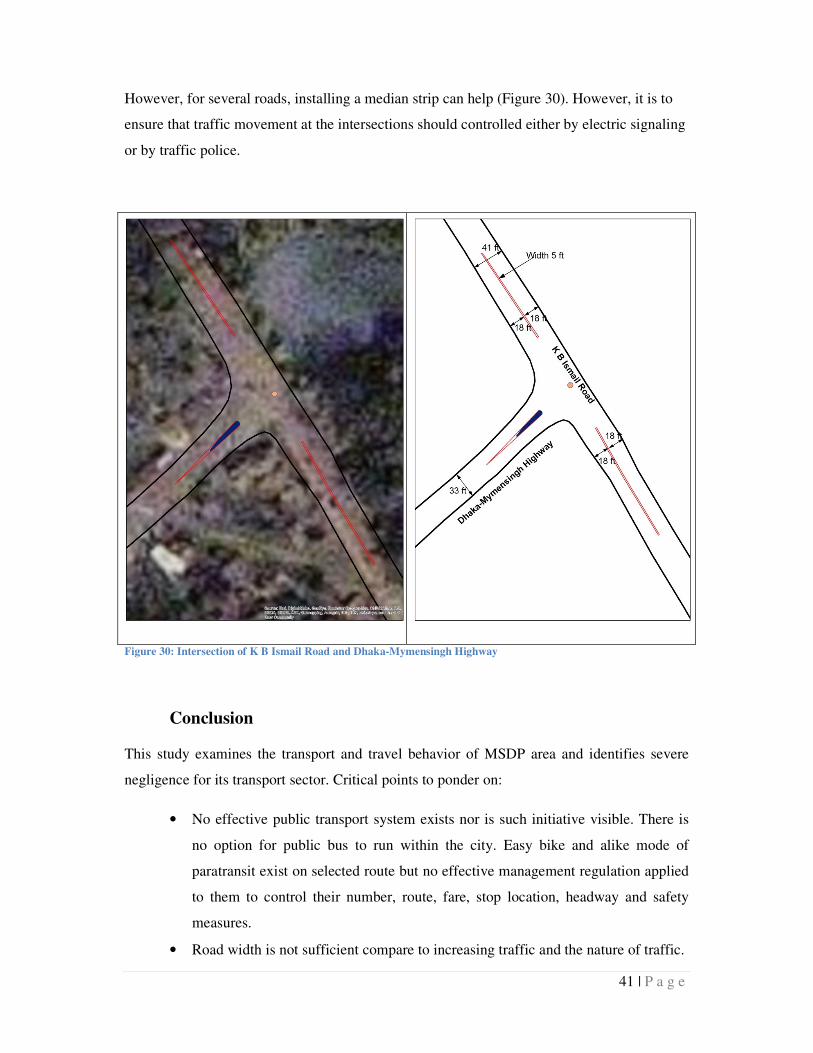
However, for several roads, installing a median strip can help (Figure 30). However, it is to
ensure that traffic movement at the intersections should controlled either by electric signaling
or by traffic police.
Figure 30: Intersection of K B Ismail Road and Dhaka-Mymensingh Highway
Conclusion
This study examines the transport and travel behavior of MSDP area and identifies severe
negligence for its transport sector. Critical points to ponder on:
• No effective public transport system exists nor is such initiative visible. There is
no option for public bus to run within the city. Easy bike and alike mode of
paratransit exist on selected route but no effective management regulation applied
to them to control their number, route, fare, stop location, headway and safety
measures.
• Road width is not sufficient compare to increasing traffic and the nature of traffic.
42 | P a g e
• Travel behavior shows a huge number of shorter trip which can be easily
converted to walking trip by ensuring pedestrian facilities and safety. Pedestrian
mobility needs to ensure specially in busy commercial area, and in link between
stoppage and school, urban services
• Walking accounts for one third of trips. However, proportion amount of space is
not allocated for it. As a result, walking people occupy the road space which has
been designed for vehicles. Footpaths are provided only with few sections of
roads which are often encroached by adjoined business or my informal business.
The informal activities sometimes even occupy a section of the road and cause
congestion.
• Road geometry is insufficient specially to function in emergency situation.
Approximate 70.17% Urban and 78.42% Rural of roads are narrow and
emergency vehicles cannot operate on it.
• Traffic management specially around the commercial areas is poor. Governance is
poorly visible. Due to regulatory ineffectiveness the busy areas looks crowded,
and congested.
1 | P a g e
Appendix-A: House Hold
Questionnaire Travel Pattern Study
Questionnaire for Household Interview Survey
Mymensingh Strategic Development Planning
Travel Pattern
Member Trip
Purpose
Major
Mode*
Trip Rate
(trip/week)
Destination
(area/ward)
Cost (Tk.) Travel
Time (min)
1 Work
Shopping
Education
Social
Others
2 Work
Shopping
Education
Social
Others
3 Work
Shopping
Personal Information
Sex Age Income Vehicle ownership Family Member
Holding No………………………..
Road No…………………………….
Ward no…………………………….
Lat……………………………………..
Long……………………………………
2 | P a g e
Education
Social
Others
4 Work
Shopping
Education
Social
Others
5 Work
Shopping
Education
Social
Others
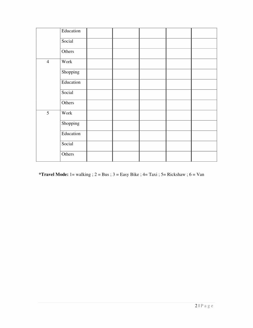
*Travel Mode: 1= walking ; 2 = Bus ; 3 = Easy Bike ; 4= Taxi ; 5= Rickshaw ; 6 = Van
3 | P a g e
Appendix-B: Name of Road
Required to Widen (m.)
Road Name (Required Widen) Length (Meter)
Alia Madrasah Bypass 1310.012
Amritu Babo Road 119.9091
Baghmara Road 668.5259
BD Road 425.7921
Boundary Road 184.4266
College Road 688.7246
Datlat Munsi Road 176.1503
Doulat Munsi Road 1212.926
Durgabari Road 409.276
Eshan Chokroborti Road 222.677
Golapjan Road 719.1061
Hari Kishor Road 130.6948
Hisbullah Road 116.5582
K. B Ismail Road 638.3531
Kalibari Road 270.5079
Kewatkhali WAPDA Road 1633.405
Malgudam Road 375.5011
Maychuya Bazar Zillapi Potti Road 263.7867
Mir Bari Road 327.104
Moha Raja Road 325.5378
Monmohon Road 253.1349
Mritunjoi School Road 143.8634
Naha Road 309.5705
Natokghorlen C.K Ghosh Road 254.2648
Ramkrismno Mission Road 32.21533
Sakhari Potti Road 66.01243
Senbari Road 1325.188
Sohid Srity Sarak 733.5776
T.N Ray Road 672.7028
4 | P a g e
Appendix- C: Traffic
Volumes at Intersections
Figure 31 Bridge Intersection
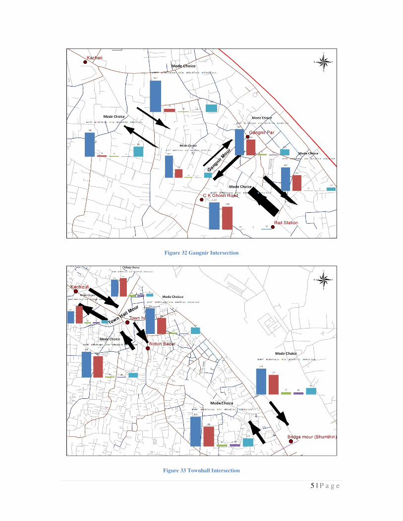
5 | P a g e
Figure 32 Gangnir Intersection
Figure 33 Townhall Intersection
6 | P a g e
Figure 34 Kawatkhali Bypass Intersection
7 | P a g e
Appendix- D: Cross Section
of Road with Footpath
Traffic Lanes Footpath Footpath
3 ft 21ft 3 ft
Figure 35 Cross Section of Road with Footpath
Figure 36 Design of Road with Footpath