1
! . ! . ! . ! . ! . ! . ! . ! . ! . ! ^ _ ( ! . ! . ! . ! . ! . Myitkyina Loikaw Hpa-An Hakha Sagaing Dawei Bago Magway Mandalay City Nay Pyi Taw City Mawlamyine Sittwe Yangon City Taunggyi Pathein Ayeyarwady (6,184,829) Bago (4,867,373) Chin (478,801) Kachin (1,642,841) Kayah (286,627) Kayin (1,504,326) Magway (3,917,055) Mon (2,054,393) Rakhine (2,098,807) Sagaing (5,325,347) Shan (5,824,432) Tanintharyi (1,408,401) Yangon (7,360,703) Mandalay (6,165,723) Nay Pyi Taw (1,160,242) BHUTAN CAMBODIA VIETNAM CHINA LAOS THAILAND BANGLADESH INDIA 100°E 100°E 95°E 95°E 90°E 90°E 25°N 25°N 20°N 20°N 15°N 15°N 10°N 10°N Disclaimer: The names shown and the boundaries used on this map do not imply official endorsement or acceptance by the United Nations. MYANMAR Population & Population Density by State and Region (2014 Census) Myanmar Information Management Unit Data Sources: Census 2014 Base Map - MIMU Population - 2014 Census, DOP Places: MIMU Boundaries: WFP/MIMU Map ID: MIMU841v06 Creation Date: 21 March 2017. A4 Projection/Datum: Geographic/WGS84 Bay of Bengal / [email protected] www.themimu.info Andaman Sea Legend ! ^ _ ( Capital ! . State/Region Capital Coast Line State/Region Boundary International Boundary Not Enumerated Townships Population Density (per/sq-km) 13.3 - 50 51 - 100 101 - 300 301 - 741.9 Kachin 1,642,841 State/Region Total Population 0 100 200 50 Kilometers Copyright © Myanmar Information Management Unit 2017. May be used free of charge with attribution.

MYANMAR Population & Population Density by State and ...themimu.info/sites/themimu.info/files/documents/Population_Map... · THAILAND BANGLADESH INDIA 100°E 100°E 95°E ... Population

  • Upload
    vannhu

  • View
    234

  • Download
    2

Embed Size (px)

Citation preview

!.

!.

!.

!.

!.

!.

!.

!.

!.

!̂_(

!.

!.

!.

!.

!.

Myitkyina

Loikaw

Hpa-An

Hakha

Sagaing

Dawei

Bago

Magway

Mandalay City

Nay Pyi Taw City

Mawlamyine

Sittwe

Yangon City

Taunggyi

Pathein

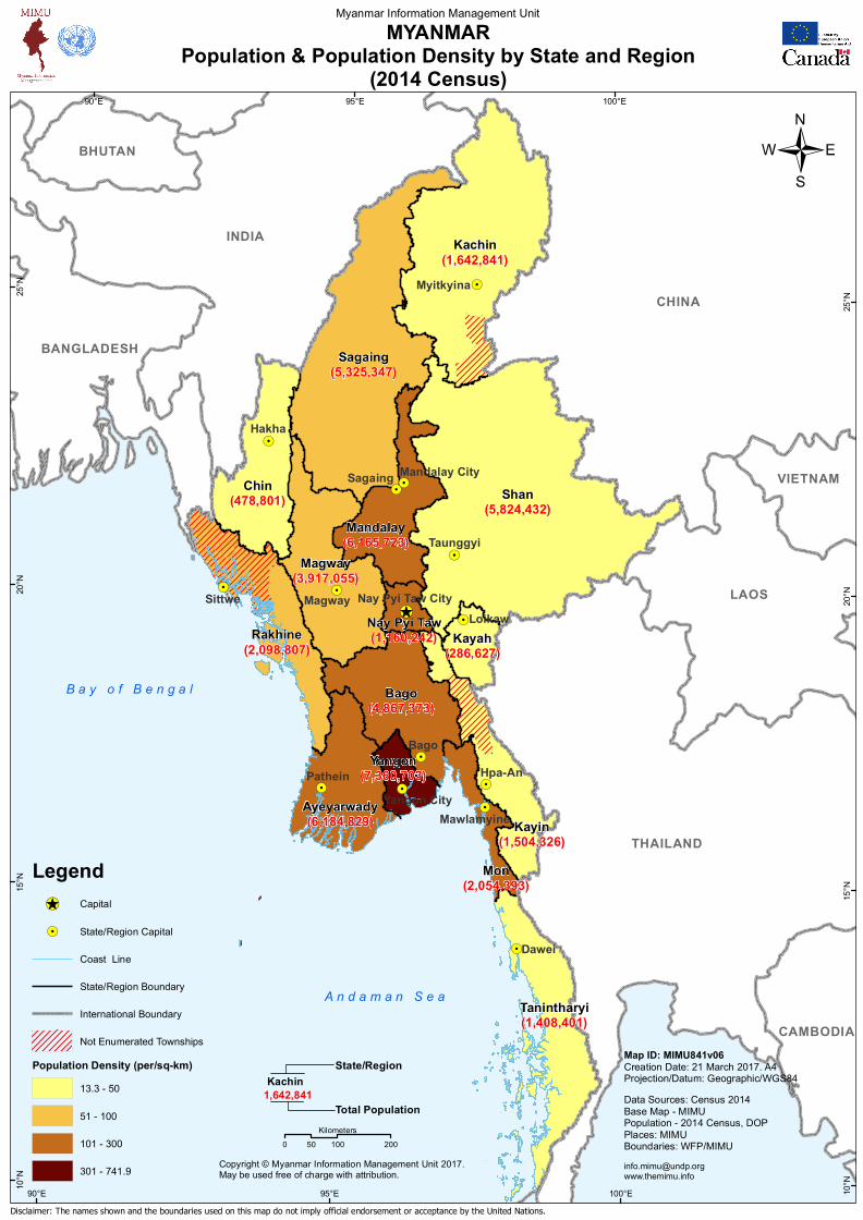
Ayeyarwady(6,184,829)

Bago(4,867,373)

Chin(478,801)

Kachin(1,642,841)

Kayah(286,627)

Kayin(1,504,326)

Magway(3,917,055)

Mon(2,054,393)

Rakhine(2,098,807)

Sagaing(5,325,347)

Shan(5,824,432)

Tanintharyi(1,408,401)

Yangon(7,360,703)

Mandalay(6,165,723)

Nay Pyi Taw(1,160,242)

BHUTAN

CAMBODIA

VIETNAM

CHINA

LAOS

THAILAND

BANGLADESH

INDIA

100°E

100°E

95°E

95°E

90°E

90°E

25°N

25°N

20°N

20°N

15°N

15°N

10°N

10°N

Disclaimer: The names shown and the boundaries used on this map do not imply official endorsement or acceptance by the United Nations.

MYANMARPopulation & Population Density by State and Region

(2014 Census)

Myanmar Information Management Unit

Data Sources: Census 2014Base Map - MIMUPopulation - 2014 Census, DOPPlaces: MIMUBoundaries: WFP/MIMU

Map ID: MIMU841v06Creation Date: 21 March 2017. A4Projection/Datum: Geographic/WGS84

B a y o f B e n g a l

/

[email protected]

A n d a m a n S e a

Legend!̂_( Capital

!. State/Region Capital

Coast Line

State/Region Boundary

International Boundary

Not Enumerated TownshipsPopulation Density (per/sq-km)

13.3 - 50

51 - 100

101 - 300

301 - 741.9

Kachin1,642,841

State/Region

Total Population

0 100 20050Kilometers

Copyright © Myanmar Information Management Unit 2017.May be used free of charge with attribution.