Embed Size (px)
Citation preview

MVG 6 - ACACIA FORESTS AND WOODLANDS
Acacia aneura woodland near Yenloora, Qld (Photo: M. Fagg)
Overview
Almost all Acacia forests and woodlands are dominated by a single Acacia species, which co-
occurs with other members of the genus only in transitional segments of environmental
gradients. Other genera may occur as subdominants.
Species composition and the identity of the dominant species vary along rainfall gradients, with
substrate and to a lesser extent rainfall seasonality (Beadle 1981; Johnson and Burrows 1994).
Where the Acacia stratum is dense, the understorey and ground layer are typically sparse,
scattered shrubs and tussock grasses are present in more open stands.
MVG 6 comprises several subgroups including: “brigalow” and “gidgee”, which dominate
forests or woodlands that are restricted to subtropical and nearby tropical eastern Australia on
productive clay soils in sub-humid climates; and “mulga” and “lancewood”, which dominate
woodlands on stony landscapes around the eastern fringe of the arid zone and across the
northeast semi-arid landscapes adjoining savanna.
Mulga vegetation takes on a variety of structural expressions and is consequently classified
partly within MVG 6, in accordance with the Kyoto Protocol definition of forest cover in
Australia (trees > 2 m tall and crown cover > 20%, foliage projective cover > 10%); and partly
within MVG 13 where the tree canopy layer is sparser, or MVG 16 where the woody dominants
are not predominantly single-stemmed.
Temperate humid Acacia forests tend to be part of dynamic mosaics within eucalypt forest
landscapes, often have emergent eucalypts within them and share virtually all of their species
with surrounding eucalypt forests. In this national scale classification, they are grouped with
MVGs 2 and 3.
Acacia-dominated vegetation in southern, central and Western Australia takes on structural
expressions of open woodland and shrubland, and is therefore assigned to MVGs 13 and 16.
Extends from central-northern New South Wales in an arc around the northeast of Australia’s
semi-arid zone through central Queensland and into the Northern Territory.
Facts and figures
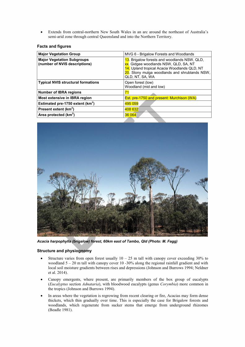
Major Vegetation Group MVG 6 - Brigalow Forests and Woodlands
Major Vegetation Subgroups (number of NVIS descriptions)
13. Brigalow forests and woodlands NSW, QLD, xx. Gidgee woodlands NSW, QLD, SA, NT 14. Upland tropical Acacia Woodlands QLD, NT 20. Stony mulga woodlands and shrublands NSW, QLD, NT, SA, WA
Typical NVIS structural formations Open forest (low) Woodland (mid and low)
Number of IBRA regions 71
Most extensive in IBRA region Est. pre-1750 and present: Murchison (WA)
Estimated pre-1750 extent (km2) 495 059
Present extent (km2) 408 632
Area protected (km2) 36 064
Acacia harpophylla (brigalow) forest, 60km east of Tambo, Qld (Photo: M. Fagg)
Structure and physiognomy
Structure varies from open forest usually 10 – 25 m tall with canopy cover exceeding 30% to
woodland 5 – 20 m tall with canopy cover 10 -30% along the regional rainfall gradient and with
local soil moisture gradients between rises and depressions (Johnson and Burrows 1994; Neldner
et al. 2014).
Canopy emergents, where present, are primarily members of the box group of eucalypts
(Eucalyptus section Adnataria), with bloodwood eucalypts (genus Corymbia) more common in
the tropics (Johnson and Burrows 1994).
In areas where the vegetation is regrowing from recent clearing or fire, Acacias may form dense
thickets, which thin gradually over time. This is especially the case for Brigalow forests and
woodlands, which regenerate from sucker stems that emerge from underground rhizomes
(Beadle 1981).
Leaves of the dominate layer vary from notophyll phyllodes or leaves (20 – 45 cm2) to
nanophyll phyllodinous or cladodinous needles (0.25 – 2.5 cm2), with the latter predominating in
drier areas (Johnson & Burrows 1994).
Understories may include open layers of shrubs with typically sparse ground layers of tussock
grasses and forbs that vary depending on canopy cover, rainfall and substrate.
Indicative flora
A single species of Acacia typically dominates, which co-occurs with other members of the
genus only in transitional segments of environmental gradients.
Co-dominants or emergents include Eucalyptus, Casuarina and various ‘vine scrub’ genera. The
ground layers are generally sparse and comprised of tussock grasses and forbs. Associated
species include shrub species such as Eremophila, Dodonaea, chenopods such as Atriplex,
Maireana, Sclerolaena and grasses such as, Aristida, Austrostipa and Triodia.
Four Major Vegetation Subgroups are recognised, of which two also occur in MVG 13 and one
in MVG 16. Two of the subgroups are dominated by Acacia in the ‘Microneurae’ group within
section Plurinerves of the genus, with tussock grasses primarily of tribes Chlorideae and
Sporoboleae on fine-textured alkaline soils. Two other subgroups are dominated by Acacia
species from section Juliflorae of the genus, with tussock grasses primarily of tribes Aristideae
and Andropogoneae on coarse-textured acid soils (Johnson & Burrows 1994).
o Brigalow forests and woodlands - are dominated by Acacia harpophylla and Casuarina
cristata, while Acacia cambagei, Acacia argyrodendron, and species of Geijera and
Eremophila may co-occur at the drier end of the rainfall gradient (Johnson and Burrows
1994; Keith 2004). In higher rainfall areas, vine scrub genera such as Alectryon,
Brachychiton, Cadellia, Carissa, Lysiphyllum, Terminalia and Ventilago occur and the
vines Capparis, Cissus and Jasminum, may be scattered within the canopy or midstorey.
Various eucalypts (section Adnataria) may emerge above the canopy. The groundcover is
typically sparse with specie sfrom the genera Abutilon, Brunoniella, Einadia, Enchylaena,
Sida and grasses primarily of the Chlorideae and Sporoboleae tribes (Johnson and
Burrows 1994).
o Gidgee woodlands (also represented in MVG 13) - include Acacia cambagei as the
primary dominant, and there may be scattered emergent eucalypts (Eucalyptus section
Adnataria). Co-occurring shrubs are sparse but may include species of Alectryon,
Atriplex, Carissa, Enchylaena, Eremophila, Senna and Terminalia. In the swales of red
desert dunefields, Acacia georginae becomes the sole dominant tree, while in the higher
rainfall areas Acacia argyrodendron is the sole dominant. Acacia tephrina also occurs
with Acacia cambagei in the wetter northern parts of its range. The groundlayer
comprises a sparse cover of tussock grasses including species of Astrebla, Enteropogon,
Paspalidium and Sporobolus (Johnson and Burrows 1994; Keith 2004; Neldner et al.
2014).
o Upland tropical Acacia woodlands - are most commonly dominated by Acacia shirleyi,
which is replaced by Acacia catenulata on slightly deeper soils and Acacia petraea in
drier areas (Johnson and Burrows 1994). The Acacia canopy may include emergents of
Corymbia, with Eucalyptus of section Adnataria becoming more prominent in the
subtropics. Small trees and shrubs below the Acacia canopy include species of
Petalostigma, Erythropleum and Macropteranthes, while the groundcover is grassy and
open with species primarily of the Aristideae and Andropogoneae tribes (Beadle 1981;
Johnson and Burrows 1994).
o Stony mulga woodlands and shrublands (also represented in MVG 13 and 16) -Acacia
aneura (mulga) is the primary dominant, typically present in monospecific stands, or with
scattered eucalypts (section Adnataria) emergent above the canopy. The sparse shrub
layer includes species of Atalaya, Eremophila, Senna, Dodonaea and Maireana. The
ground cover varies inversely with overstorey cover and responds to rain. It is dominated
by tussock grasses including species of Aristida, Enneapogon and Eragrostis (Johnson
and Burrows 1994; Neldner et al. 2014)

Environment
Occurs largely within the 500-900 mm annual rainfall belt with a predominance of summer
rainfall, although winter rainfall peaks occur in the south of its distribution where the climate in
western areas is more arid (Pulsford, 1984; Johnson, 1997), and annual rainfall may exceed 1000
mm in the north where there is a strong winter drought (Johnson and Burrows 1994).
Brigalow and Gidgee assemblages occur on fine textured alkaline clays and clay loams. The clay
soils often have a micro relief pattern, referred to as gilgai or melon holes, resulting from lateral
mass movement associated with wetting and drying, with the depressions sometimes
intermittently filling with water (Keith 2004)
Upland tropical Acacia and mulga assemblages are associated with coarsely textured acid loams
and sandy loams (Isbell, 1962; Bui and Henderson, 2003)
Different subgroups occur on contrasting substrates:
o Brigalow forests and woodlands occur on lowland plains and depressions with deep fine
textured alkaline soils from central Queensland to central northern New South Wales
where mean annual rainfall is between 500 and 750 mm.
o Gidgee woodlands occur on deep fine texted soils in landscape depressions, replacing
Brigalow woodlands as mean annual rainfall declines below 550 mm in central and
western Queensland, and adjoining areas of the Northern Territory, South Australia and
northern New South Wales.
o Upland tropical Acacia woodlands occur on shallow coarse-textured acid soils typically
on dissected uplands of central and northern Queensland and west to the northern
Territory where mean annual rainfall is between 500 and 750 mm.
o Stony mulga woodlands and shrublands occur on open plains with light-textured loams
and hard subsoils, high levels of iron and low phosphorus where mean annual rainfall is
between 200 and 500 mm from central Queensland to the west Australian coast.
Woodland forms occupy a fraction of this range around the upper rainfall range in central
and western Queensland.
Landforms also vary between subgroups with Brigalow and Gidgee assemblages associated with
rolling downs, outwash slopes and depositional areas, while upland Acacia and stony mulga
assemblages are associated with residual uplands, associated slopes and stony peneplains
(Johnson and Burrows 1994; Neldner et al. 2014). About 10% of remnants are associated with
river and creek flats. The remainder are associated with old loamy and sandy plains, basalt
plains and hills, or hills and lowlands on metamorphic or granitic rocks (Accad et al. 2001).
Geography
Occurs in an arc from northern plains of New South Wales through central Queensland, with
patchy occurrence extending from central northern Queensland into the Northern Territory.
Grows west of the Great Dividing Range on the edge of subtropical and semi-arid zone of New
South Wales and Queensland.
The bounds of the arc are determined by rainfall patterns moderated by the influence of soil
texture and local topography on available soil moisture (Beadle 1981; Johnson and Burrows
1994). The inner boundary of the arc aligns roughly with the 400 – 500 mm annual rainfall
isohyets, beyond which MVG 6 is replaced by MVG 13. The outer boundary of the arc is
loosely defined by the 900 – 1000 mm rainfall range, beyond which MVG 6 is replaced by
assemblages associated with the rainforest, woodland and savannah MVGs.
Largest areas are in Queensland (232 091 km2).
Change
Approximately 17.5% of the estimated pre-1750 extent cleared accounting for 8.5% of total
clearing in Australia.
Approximately 86 000 km2 cleared since European settlement.
Clearing has had disproportionate effects among the subgroups, with less than 10% of Brigalow
forest and woodland remaining in Queensland and New South Wales (NSW Scientific

Committee 2002; Neldner 2014), while more than 90% of the Upland tropical Acacia woodlands
remain in Queensland (Neldner et al. 2014). Much of the clearing took place in the post-war era
when new machinery made possible the broad-scale clearing of suckering Acacias on clay plains
(Keith 2004).
Foremost threats are changes in fire regime and over-grazing (including cattle, sheep and feral
animals) (NLWRA 2001b).
Overgrazing by cattle and feral vertebrates has degraded extensive areas of Gidgee and Mulga
woodlands, resulting in a lack of regeneration, soil compaction and erosion, reduction of woody
debris, as well as disruption of grove-intergrove patterns critical to water movement, resource
capture and landscape function (Tongway and Ludwig 1990).
Mining in the Bowen Basin in Queensland and logging for fence posts in the Brigalow Belt
South, Nandewar and Darling Riverine Plains bioregions of New South Wales continues to
threaten significant areas of the Brigalow ecological community (Butler 2007).
The low density of herbage in most types of Brigalow vegetation suggests that fire has been
historically rare in the Brigalow ecological community. It becomes a serious threat to remnant
Brigalow where fuel characteristics have been changed (e.g. by the presence of high biomass
introduced pasture grass species such as Cenchrus ciliaris (Buffel Grass), Chloris gayana
(Rhodes Grass) or Panicum maximum (Green Panic Grass) in, or adjacent to, Brigalow
woodlands (Butler 2007).
Tenure
Acacia Forests and Woodlands mainly occur on leasehold land.
Some areas have recently been purchased for conservation by government and non-government
organisations in Queensland and New South Wales.
New South Wales: protected areas, leasehold and freehold land
Queensland: freehold and leasehold land, protected areas and some state forests
Northern Territory:
South Australia:
Key values
Biodiversity (endangered ecological communities and species).
Maintenance of landscape function and soil productivity.
Remnant populations of a wide range of vertebrate and invertebrate species.
Pastoral production.
List of key management issues
Ongoing clearing of remnant vegetation in Queensland and New South Wales.
Grazing pressure from both domestic stock and feral animals. Trampling and grazing by large
herbivores has a number of impacts. Trampling compresses soil, can reduce the amount of leaf
litter and woody debris, and alters the composition and density of herbs and shrubs in the
understorey of the Brigalow ecological community (Government of Australia 2013)
Interactions between stocking rates and drought cycles, implementing pastoral management
systems that avoid cumulative legacies of soil degradation caused by sustained overgrazing into
successive drought episodes.
Location and access to artificial watering points, which are associated with intensification of
herbivore activity and associated impacts.

Control of introduced grasses on pastoral lands to limit their influence on fire regimes and native
groundcover.
Fire regimes, recognising that some introduced grasses such as Cenchrus ciliaris (buffel grass)
burn with greater intensity than native pasture grasses, thereby altering regeneration responses of
trees and shrubs.
Indirect effects of climate change, through increasing temperatures and lower and more erratic
rainfall, on the extent and frequency of unplanned, high-intensity fires (Butler 2007).
Feral animals. Feral pigs are probably the most widespread and problematic pest animal in MVG
6, although goats, cane toads, cats and foxes are also serious threats (Butler 2007).
Long term monitoring to inform future management strategies.
References
Accad A., Neldner V.J., Wilson B.A. and Niehus R.E. (2001). Remnant vegetation in Queensland.
Queensland Herbarium. Qld Environmental Protection Agency. Brisbane.
Australian Surveying and Land Information Group (1990) Atlas of Australian Resources. Volume 6
Vegetation, AUSMAP, Department of Administrative Services, Canberra, 64pp. & 2 maps.
Beadle N.C.W. (1981) The Vegetation of Australia. Cambridge Univ. Press, Cambridge, 690pp.
Beard J.S. (1976) Murchison. Vegetation Survey of Western Australia, 1:1 000 000 series. Explanatory
notes to sheet 6. Univ. of Western Aust. Press, Nedlands, 141pp. & map
Benson J.S., Allen C.B., Togher C. and Lemmon J. (2006). New South Wales Vegetation Classification
and Assessment: Part 1 Plant communities of the NSW Western Plains. Cunninghamia 9, 383–450.
Bui E.N. and Henderson B.L. (2003). Vegetation indicators of salinity in northern Queensland. Austral
Ecology 28, 539–552.
Butler DW (2007). Recovery plan for the "Brigalow (Acacia harpophylla dominant and co-dominant"
endangered ecological community (draft of 1 May 2007). Report to the Department of the
Environment and Water Resources, Canberra. Qld National Parks and Wildlife Service, Brisbane.
Government of Australia (2013). Approved Conservation Advice for the Brigalow (Acacia harpophylla
dominant and co-dominant) ecological community. Department of the Environment, Canberra.
Isbell R.F. (1962). Soils and vegetation of the Brigalow Lands, Eastern Australia. Soils and Land Use
Series No. 43. CSIRO.
Johnson R.W. (1997). The impact of clearing on brigalow communities and consequences for
conservation. In ‘Conservation outside nature reserves’ (eds. P Hale and D Lamb). Centre for
Conservation Biology, the University of Queensland. Brisbane. pp. 359–63.
Johnson R.W. and Burrows W.H. (1994) Acacia open forests, woodlands and shrublands. In:
Australian Vegetation (ed. R.H. Groves) pp. 257-290. Cambridge Univ. Press, Cambridge.
Keith D. (2004) Ocean Shores to Desert Dunes. The native vegetation of New South Wales and the
ACT. Department of Environment and Conservation (NSW), Hurstville
National Land and Water Resources Audit (2001) Australian Native Vegetation Assessment 2001.
National Land and Water Resources Audit, Canberra, 332pp.
National Land and Water Resources Audit (2001a) Landscape Health in Australia, National Land and
Water Resources Audit, Canberra.
National Land and Water Resources Audit (2001b) Rangelands—Tracking Changes, National Land
and Water Resources Audit, Canberra.
Neldner, V.J., Niehus, R.E., Wilson, B.A., McDonald, W.J.F. and Ford, A.J. (2014). The Vegetation of
Queensland. Descriptions of Broad Vegetation Groups. Version 1.1. Queensland Herbarium,
Department of Science, Information Technology, Innovation and the Arts.
NSW Scientific Committee (2002). Final Determination Brigalow within the Brigalow Belt South,
Nandewar and Darling Riverine Plains bioregions - endangered ecological community listing. New
South Wales Scientific Committee, Hurstville.

Pulsford I.F. (1984). Conservation status of Brigalow Acacia harpophylla in New South Wales. In ‘The
Brigalow Belt of Australia’ (ed. A Bailey). The Royal Society of Queensland, Brisbane. pp. 161–75.
Tongway D. J. and Ludwig, J. A. (1990) Vegetation and soil patterning in semi-arid mulga lands of
Eastern Australia. Australian Journal of Ecology 15, 23–34.
Data sources
Interim Biogeographic Regionalisation for Australia (IBRA), Version 6.1.
Land Tenure in Australia's Rangelands (1955 to 2000), National Land and Water Resources Audit.
National Vegetation Information System, Version 4.1.
1996/97 Land Use of Australia, Version 2.
Collaborative Australian Protected Areas Database – CAPAD 2004 – Terrestrial.
Species Profile and Threats (SPRAT) database Australian Government Department of the Environment
and Heritage; online at URL: http://www.deh.gov.au/cgi-bin/sprat/public/sprat.pl .
Notes
The area protected has increased by 23 000 km2 since NVIS 1, reflecting improved reservation
in the arid and semi-arid zones.
See the Introduction to the MVG fact sheets for further background on this series.


![Index [link.springer.com]978-94-017-3209-3/1.pdf · Index A Abies concolor, 174 Abies sp., 168 Acacia albida, 275 Acacia auriculiformis, 450, 472 Acacia catechu, 472 Acacia saligna,](https://img.pdfslide.us/doc/110x75/5d56391188c9938f7e8bcfe4/index-link-978-94-017-3209-31pdf-index-a-abies-concolor-174-abies-sp.jpg)