Embed Size (px)
Citation preview
A. Ruas (ed.), Advances in Cartography and GIScience. Volume 1: Selection from ICC 2011, 497 Paris, Lecture Notes in Geoinformation and Cartography, DOI 10.1007/978-3-642-19143-5_28, © Springer-Verlag Berlin Heidelberg 2011
Multiscale Hypsometric Mapping
Timofey Samsonov
Faculty of Geography, Moscow State University Russia [email protected]
Abstract
Multiple representations of geographic objects draw one of the main focuses in modern cartographic research. Initial works were concentrated on multiresolution databases and elevation models derivation through generalization process. Development of interactive computer mapping in 90-00’s lead to growth of interest in visual representations of multilevel objects. However, the task of multiscale mapping of earth topography has not been paid a due attention. In this work a complete technology of making multiscale hypsometric maps is proposed, beginning from scales and projection definition, walking through database design and DEM generalization with novel algorithm and finally outlining map preparation using hypsometric tints, contours and hill shading.
1- Background and objectives
Multiscale mapping is among the most prominent and problematic areas in modern cartography. Casting away the limits of fixed-scale maps cartogra-phers go into detail of multiresolution databases design, real-time generali-zation, map layers structure, scale-dependent behavior and symbolization, while trying to keep representation clear and credible. During the 80-00’s large amount of work had been done to develop and extend this area of knowledge. Most of results were yielded in digital space, including data generalization for multiresolution databases (Buttenfield 1993, Muller et al. 1995, Li 2007) and optimal database structure (Jones et al. 1996, Frye 2006).
In recent decade we watched the growing interest in visual, symbolic aspects of multiple representations. Bedard and Bernier (2002) developed a VUEL concept to integrate geometric, semantic, and semiotic presenta-tion of object in multiscale environment. Cecconi et al. (2004) examine limits of LoDs' applicability for display in various scales and accentuate the primary role of symbolization in multiscale maps. Brewer and Butten-field (2009) analyze data sensitivity for scale variation and propose effec-tive combination of symbology and geometry changes.
Despite variety of existing works in multiple presentations, they have not covered all the geographic phenomena to an equal degree in visual context. Most of them concern discrete objects, which cartographic representation is usually planar (2D): roads, rivers, buildings etc. The task of multiscale mapping of relief have not been paid deserved attention.
Relief concept is used for describing earth topography. It can be logically divided into separate forms, or treated as continuous surface. Both models are useful in their own area and supplement each other in cartographic relief presentation and generalization.
Manual contour drawing is made within neighboring fragments of contour levels, which are topologically related and correspond to the same relief form. Scale reduction and accompanying generalization process lead to representation of higher hierarchical level of topography on the map. Con-tour interval is increased consecutively. According to Zarutskaya (1958) small-scale hypsometric relief representation should be geographically credible and keeping the most distinct features of great forms which are conditional to their structure and genesis, with respect to scale and purpose of the map.
Careful analysis of guides and instructions for topographic mapping re-veals that beginning from scale of 1:200 000 relief forms are extensively exaggerated and contours are deliberately shifted and stylized to save the morphological features typical for relief of certain genesis. Imhof (1982) also singles out scales smaller than 1:100 000. He mentions that simplifi-cation of lines at these scales extends more or less over the whole map image and not only in particular places.
Scale dependency is also present in hillshading technique and hypsometric tints selection. As Imhof states, tones and mutual contrasts of small-scale hillshading are dependent primarily on elevations and differences in eleva-tion, and no longer on the angle of slope. Stylized symbols for formations gradually replace individual features (Imhof 1982).
498 T. Samsonov
Multiscale Hypsometric Mapping 499
Hypsometric layers height steps and colors obey scale-dependent rules of construction. In small scales steps are usually based on geometric progres-sion while in large and middle scales steps can be equal as contour inter-val. Colors should be adapted to the steps chosen, thus in small scales contrast between neighboring layers will be more prominent and number of colors will be less. Scale coloring can also change gradually transition-ing from spectral in small scales to more naturalistic in large ones.
All these suggestions help us to formulate three basic principles of multi-scale hypsometric mapping:
1. Every map scale should represent relief forms of corresponding size and hierarchical level with their prominent features and structure lines.
2. At scales smaller than 1:100 000 intensive generalization should be made to maintain most characteristic forms of the earth surface.
3. While changing scales, gradual transition of representation parameters, such as contour intervals, hypsometric colors and hillshading character should be provided.
The problems of multiple relief representations and generalization are closely related to each other. The first studies in automatic relief generali-zation were based upon filtering (Loon 1978). Since the filtering method does not take structure lines into account, an adaptive technology combin-ing filtering and structural generalization was developed by Weibel (1987). Zaksek and Podobnikar (2005) combine structure lines, characteristic points and cells of smoothed model as source data for interpolation. Fan et al. (2007) developed four-stage method using low-pass, smoothing and threshold filters that are locally combined depending on slope and curva-ture of the surface. Leonowicz et al. (2009) offer using low and high quartile filters for valleys and watersheds. The same authors developed curvature-based algorithm, which is intended for production of small-scale hillshades (Leonowicz et al. 2010).
Jordan (2007) developed method based upon Strahler ordering of streams. Basins are derivated for streams of certain hierarchical order and then are filled by triangulating watershed borders. Ai and Li (2010) use similar methodology. Process is divided into three stages: stream network gener-alization using orders, large valleys extension by taking up small ones and smoothing the surface within the areas of removed valleys. Another inter-esting field of research is generalization based on Fourier analysis (Clarke 1988) and wavelet transformation (Wu 2000).
500
Careful analysis of direct contours generalization methods reveals that they are harder to implement than indirect methods based on DEM generaliza-tion because of necessity to consider topological relationships between lines (Zhang et al. 2007), complexity of structure lines derivation (Ai 2007) and interpolation difficulties when contour interval in resulting DEM should be different (Peled et al. 1989).
There are also advanced techniques for TIN generalization using morpho-logical criteria (Pedrini 2001, Wang et al. 2008). Hierarchical or pyramidal multiresolution models provide generalization mechanism for derivation of intermediate levels of detail (de Floriani et al. 1996). Great attention is paid to global hierarchical models since the amount of detailed information is growing irrepressibly (Bernardin et al. 2010)
Most investigations related to visualization of multiresolution DEMs are oriented on morphometric and hydrologic analysis (Wood 1996, Dragut et al. 2009) and demonstrate results as thematic images in variety of scales. On the whole there is a lack of methods for multiscale relief mapping and visualization, not DEM generalization and analysis. Our methodology is intended to bridge this gap and make relief image the full-fledged element of multiscale maps.
2- Approach and methods
2.1 Scales and projection
As multiscale map can be viewed in a continuous set of scales, there is obvious need in control of map appearance while scale changes. It can be made more consistently if scale range and scale series of map are defined.
Scale range defines space between largest and smallest map scales in which generalization take place. It should cover suitable scales for relief forms that will be studied and allow wide field of vision to study neighbor-ing relationships between forms. Below and above scale range map image will be simply reduced or enlarged.
T. Samsonov
Multiscale Hypsometric Mapping 501
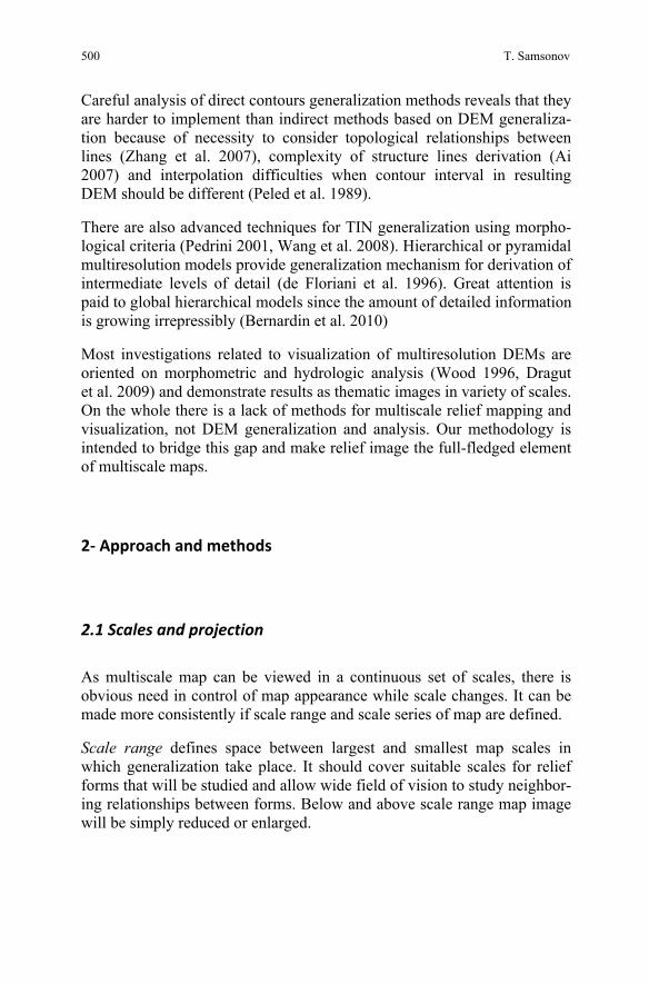
Scale series defines a discrete set of scales within scale range in which map compilation and design is made. In topography scales are usually reduced by 2-2,5 times. This rule allows gradual transition and sufficient degree of control over the map look and can be used for providing scale series (Figure 1).
Figure 1: Scale range and scale series
Map projection should be constant or gradually changing to provide cross-scale coherence.
2.2 Database design: structure and content
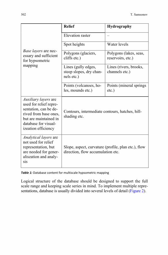
Database content for hypsometric mapping consists of relief and addition-ally hydrographic data. All other layers, such as settlements, borders, and transportation are optional and their inclusion depends on the purpose of the map. We can divide data into three functional groups: base, auxiliary and analytical (Table 1).
502
Relief Hydrography
Elevation raster –
Spot heights Water levels
Polygons (glaciers, cliffs etc.)
Polygons (lakes, seas, reservoirs, etc.)
Lines (gully edges, steep slopes, dry chan-nels etc.)
Lines (rivers, brooks, channels etc.)
Base layers are nec-essary and sufficient for hypsometric mapping
Points (volcanoes, ho-les, mounds etc.)
Points (mineral springs etc.)
Auxiliary layers are used for relief repre-sentation, can be de-rived from base ones, but are maintained in database for visual-izeation efficiency
Contours, intermediate contours, hatches, hill-shading etc.
Analytical layers are not used for relief representation, but are needed for gener-aliszation and analy-sis
Slope, aspect, curvature (profile, plan etc.), flow direction, flow accumulation etc.
Table 1: Database content for multiscale hypsometric mapping
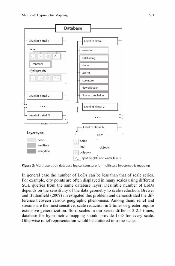
Logical structure of the database should be designed to support the full scale range and keeping scale series in mind. To implement multiple repre-sentations, database is usually divided into several levels of detail (Figure 2).
T. Samsonov
Multiscale Hypsometric Mapping 503
Figure 2: Multiresolution database logical structure for multiscale hypsometric mapping
In general case the number of LoDs can be less than that of scale series. For example, city points are often displayed in many scales using different SQL queries from the same database layer. Desirable number of LoDs depends on the sensitivity of the data geometry to scale reduction. Brewer and Buttenfield (2009) investigated this problem and demonstrated the dif-ference between various geographic phenomena. Among them, relief and streams are the most sensitive: scale reduction in 2 times or greater require extensive generalization. So if scales in our series differ in 2-2.5 times, database for hypsometric mapping should provide LoD for every scale. Otherwise relief representation would be cluttered in some scales.
504
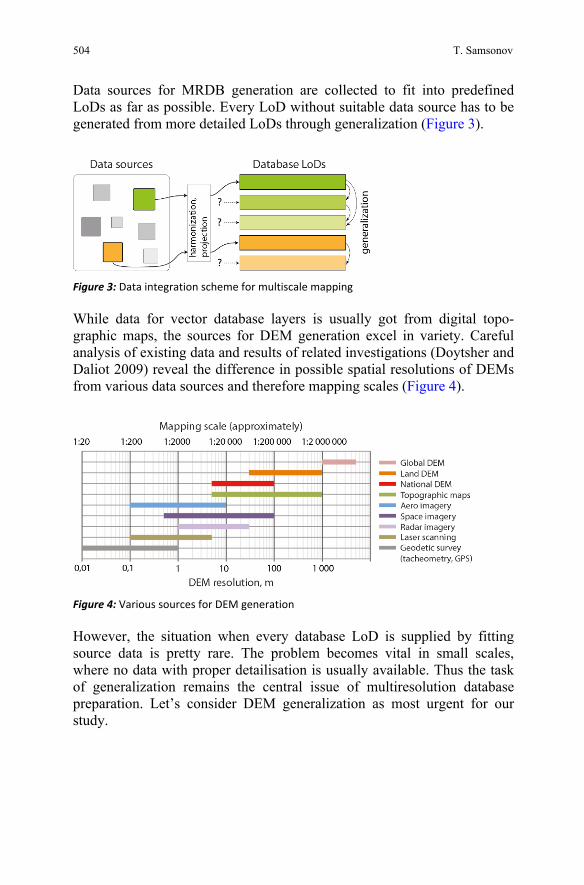
Data sources for MRDB generation are collected to fit into predefined LoDs as far as possible. Every LoD without suitable data source has to be generated from more detailed LoDs through generalization (Figure 3).
Figure 3: Data integration scheme for multiscale mapping
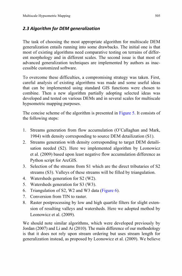
While data for vector database layers is usually got from digital topo-graphic maps, the sources for DEM generation excel in variety. Careful analysis of existing data and results of related investigations (Doytsher and Daliot 2009) reveal the difference in possible spatial resolutions of DEMs from various data sources and therefore mapping scales (Figure 4).
Figure 4: Various sources for DEM generation
However, the situation when every database LoD is supplied by fitting source data is pretty rare. The problem becomes vital in small scales, where no data with proper detailisation is usually available. Thus the task of generalization remains the central issue of multiresolution database preparation. Let’s consider DEM generalization as most urgent for our study.
T. Samsonov
Multiscale Hypsometric Mapping 505
2.3 Algorithm for DEM generalization
The task of choosing the most appropriate algorithm for multiscale DEM generalization entails running into some drawbacks. The initial one is that most of existing algorithms need comparative testing on terrains of differ-ent morphology and in different scales. The second issue is that most of advanced generalization techniques are implemented by authors as inac-cessible customized software.
To overcome these difficulties, a compromising strategy was taken. First, careful analysis of existing algorithms was made and some useful ideas that can be implemented using standard GIS functions were chosen to combine. Then a new algorithm partially adopting selected ideas was developed and tested on various DEMs and in several scales for multiscale hypsometric mapping purposes.
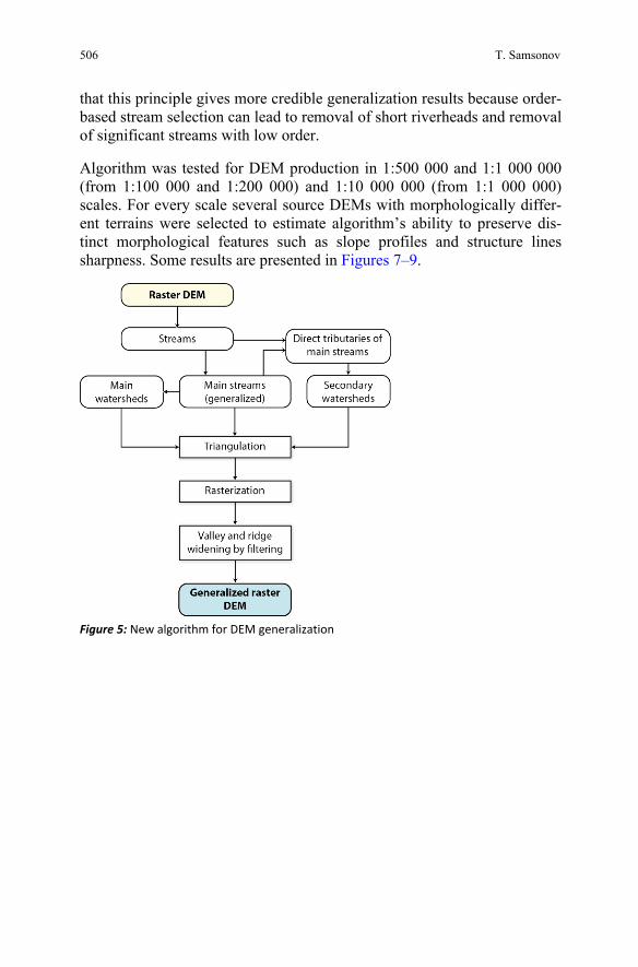
The concise scheme of the algorithm is presented in Figure 5. It consists of the following steps:
1. Streams generation from flow accumulation (O’Callaghan and Mark, 1984) with density corresponding to source DEM detailization (S1).
2. Streams generation with density corresponding to target DEM detaili-sation needed (S2). Here we implemented algorithm by Leonowicz et al. (2009) based upon least negative flow accumulation difference as Python script for ArcGIS.
3. Selection of the streams from S1 which are the direct tributaries of S2 streams (S3). Valleys of these streams will be filled by triangulation.
4. Watersheds generation for S2 (W2). 5. Watersheds generation for S3 (W3). 6. Triangulation of S2, W2 and W3 data (Figure 6). 7. Conversion from TIN to raster. 8. Raster postprocessing by low and high quartile filters for slight exten-
sion of resulting valleys and watersheds. Here we adopted method by Leonowicz et al. (2009).
We should note similar algorithms, which were developed previously by Jordan (2007) and Li and Ai (2010). The main difference of our methodology is that it does not rely upon stream ordering but uses stream length for generalization instead, as proposed by Leonowicz et al. (2009). We believe
506
that this principle gives more credible generalization results because order-based stream selection can lead to removal of short riverheads and removal of significant streams with low order.
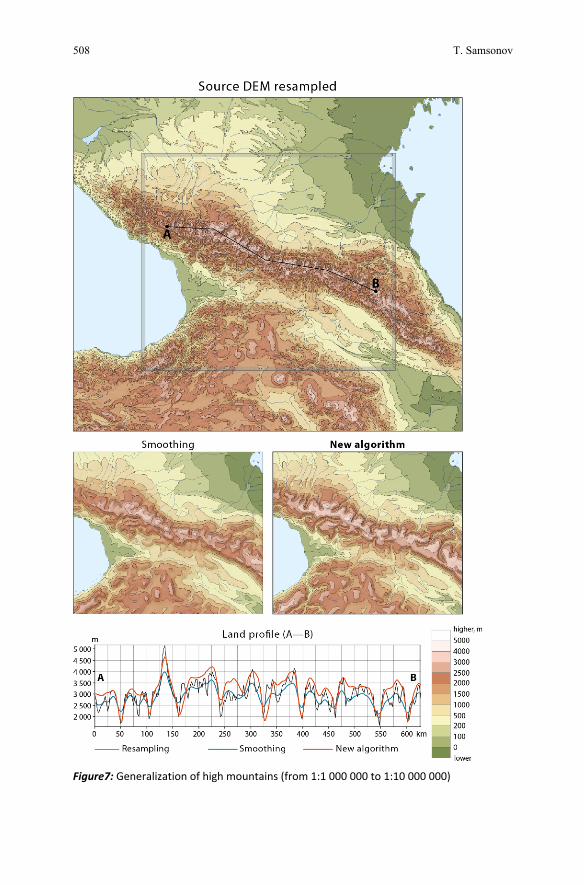
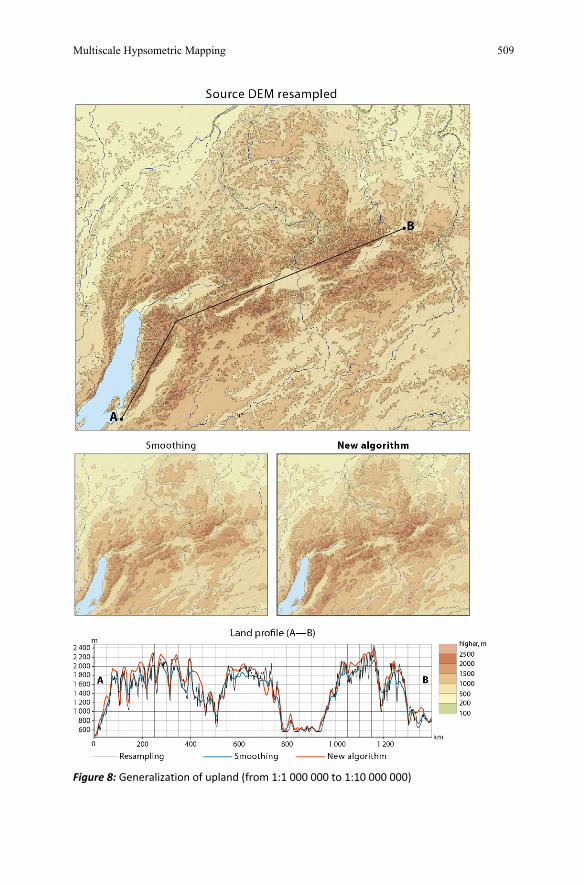
Algorithm was tested for DEM production in 1:500 000 and 1:1 000 000 (from 1:100 000 and 1:200 000) and 1:10 000 000 (from 1:1 000 000) scales. For every scale several source DEMs with morphologically differ-ent terrains were selected to estimate algorithm’s ability to preserve dis-tinct morphological features such as slope profiles and structure lines sharpness. Some results are presented in Figures 7–9.
Figure 5: New algorithm for DEM generalization
T. Samsonov
Multiscale Hypsometric Mapping 507
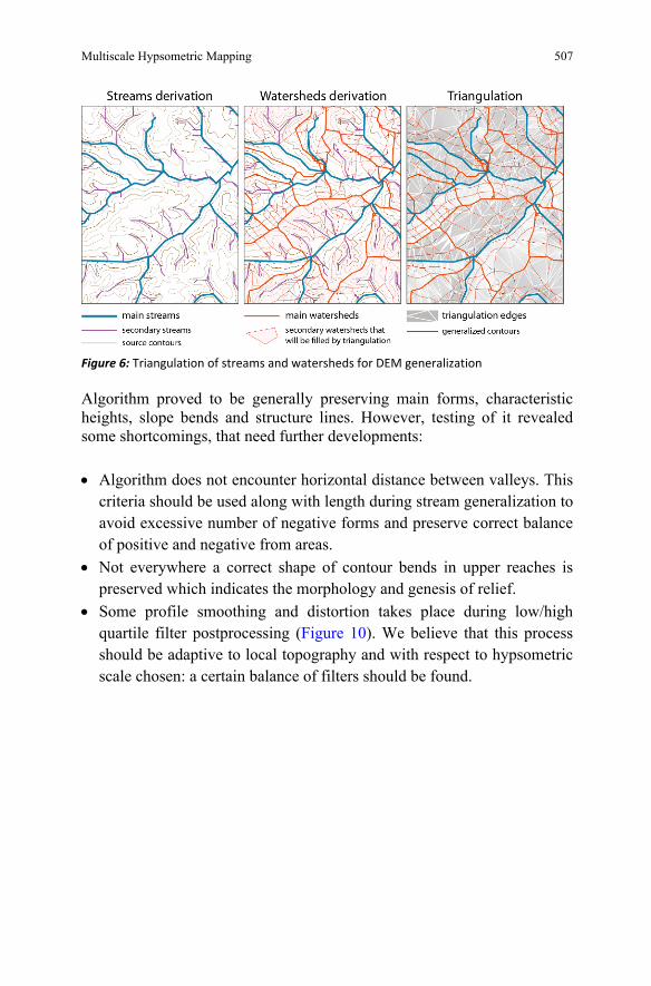
Figure 6: Triangulation of streams and watersheds for DEM generalization
Algorithm proved to be generally preserving main forms, characteristic heights, slope bends and structure lines. However, testing of it revealed some shortcomings, that need further developments:
• Algorithm does not encounter horizontal distance between valleys. This criteria should be used along with length during stream generalization to avoid excessive number of negative forms and preserve correct balance of positive and negative from areas.
• Not everywhere a correct shape of contour bends in upper reaches is preserved which indicates the morphology and genesis of relief.
• Some profile smoothing and distortion takes place during low/high quartile filter postprocessing (Figure 10). We believe that this process should be adaptive to local topography and with respect to hypsometric scale chosen: a certain balance of filters should be found.
508
Figure7: Generalization of high mountains (from 1:1 000 000 to 1:10 000 000)
T. Samsonov
Multiscale Hypsometric Mapping 509
Figure 8: Generalization of upland (from 1:1 000 000 to 1:10 000 000)

510
Figure 9: Generalization of gullies (from 1:200 000 to 1:1 000 000)
Figure 10: Widening valleys and watersheds: left – before, right – after widening.
T. Samsonov
Multiscale Hypsometric Mapping 511
2.4 Multiscale mapping and visualization
2.4.1 Layers structure and scale ranges
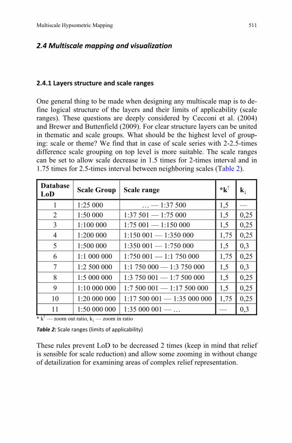
One general thing to be made when designing any multiscale map is to de-fine logical structure of the layers and their limits of applicability (scale ranges). These questions are deeply considered by Cecconi et al. (2004) and Brewer and Buttenfield (2009). For clear structure layers can be united in thematic and scale groups. What should be the highest level of group-ing: scale or theme? We find that in case of scale series with 2-2.5-times difference scale grouping on top level is more suitable. The scale ranges can be set to allow scale decrease in 1.5 times for 2-times interval and in 1.75 times for 2.5-times interval between neighboring scales (Table 2).
DatabaseLoD Scale Group Scale range *k↑ k↓
1 1:25 000 … — 1:37 500 1,5 — 2 1:50 000 1:37 501 — 1:75 000 1,5 0,25 3 1:100 000 1:75 001 — 1:150 000 1,5 0,25 4 1:200 000 1:150 001 — 1:350 000 1,75 0,25 5 1:500 000 1:350 001 — 1:750 000 1,5 0,3 6 1:1 000 000 1:750 001 — 1:1 750 000 1,75 0,25 7 1:2 500 000 1:1 750 000 — 1:3 750 000 1,5 0,3 8 1:5 000 000 1:3 750 001 — 1:7 500 000 1,5 0,25 9 1:10 000 000 1:7 500 001 — 1:17 500 000 1,5 0,25
10 1:20 000 000 1:17 500 001 — 1:35 000 000 1,75 0,25 11 1:50 000 000 1:35 000 001 — … — 0,3
* k↑ — zoom out ratio, k↓ — zoom in ratio
Table 2: Scale ranges (limits of applicability)
These rules prevent LoD to be decreased 2 times (keep in mind that relief is sensible for scale reduction) and allow some zooming in without change of detailization for examining areas of complex relief representation.
512
2.4.2 Contour levels
The most verisimilar contour system is based upon equal intervals, as stated by Imhof (1982). But it’s only scales greater than 1:1 000 000 that allow equal intervals. Beginning from 1:1 000 000 it’s almost impossible to prevent equal interval everywhere. Here the geometric progression proved to be most useful.
Despite the fact that lots of great contour systems have been developed, they need adaptation for screen visualization. The smallest recommended distance between contours on paper maps is 0.25 mm. At the same time, the smallest clearly visible distance between lines on screen is 1.5 pixels or 0.375 mm (for 0.25 mm screen cell) when using antialiasing, as was ascer-tained by Jenny et al. (2008). If antialiasing is not used, the distance would be even greater — 2 pixels or 0.5 mm. This means that contour interval has to be extended in some mountainous areas where contours are very close to each other.
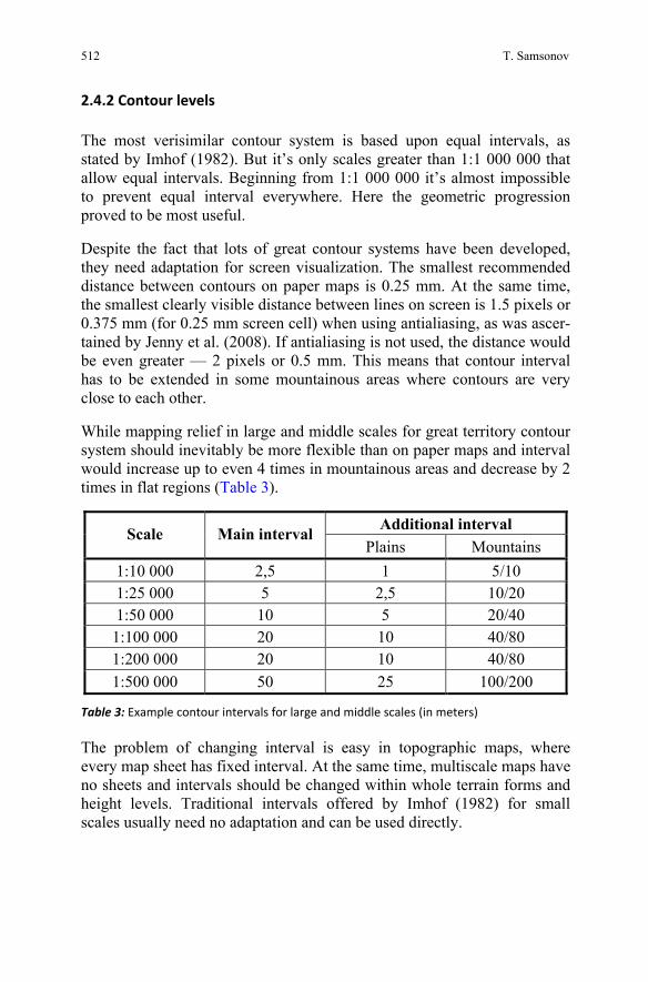
While mapping relief in large and middle scales for great territory contour system should inevitably be more flexible than on paper maps and interval would increase up to even 4 times in mountainous areas and decrease by 2 times in flat regions (Table 3).
Additional interval Scale Main interval Plains Mountains
1:10 000 2,5 1 5/10 1:25 000 5 2,5 10/20 1:50 000 10 5 20/40 1:100 000 20 10 40/80 1:200 000 20 10 40/80 1:500 000 50 25 100/200
Table 3: Example contour intervals for large and middle scales (in meters)
The problem of changing interval is easy in topographic maps, where every map sheet has fixed interval. At the same time, multiscale maps have no sheets and intervals should be changed within whole terrain forms and height levels. Traditional intervals offered by Imhof (1982) for small scales usually need no adaptation and can be used directly.
T. Samsonov
Multiscale Hypsometric Mapping 513
2.4.3 Hypsometric tints
Hypsometric scale should be developed for every map scale of the defined series. Consecutive scales of multiscale map will be coherent if tint colors are similar and successive without sudden tone changes. The more scale increases the more difficult is the task of creating distinctive layers of color. Imhof (1982) argues that number of colors should not exceed 6-10, otherwise they will be hard to distinguish. Therefore in large scales, where contour interval is small but terrain forms are relatively large in size, a transition from layered to gradient color shading would be effective.
2.4.5 Hillshading
Hillshading of already generalized DEM is rather simple using standard GIS instruments. We also recommend combining oblique and vertical hill-shading in any scales, as this kind of shading reveals ridges and valley bottoms clearly. In smaller scales there usually more need in exaggeration of DEM to give hillshading more contrast (up to 10 times). In large and middle scales exaggeration factor can usually be set to 1-5 when combining with hypsometric tints and contours.
3- Results
The proposed methodology was applied in preparation of multiscale hyp-sometric map of the European part of Russia. Esri ArcGIS Desktop 10 software was used as it allows implementing of all stages of proposed methodology. The scale range of the map extends from 1:25 000 to 1:50 000 000 and the series includes 11 scales differing in 2-2.5 times from each other. Data sources used in this project include public Russian topographic maps of scales 1:25 000—1:1 000 000, and free digital eleva-tion models ASTER GDEM and USGS GTOPO30. In large and middle scale the coverage of the map is fragmented, which is caused by availabil-ity of suitable source data. The scale of 1:25 000 is available on the Black sea coast of the Northern Caucasus, and the largest scale for Central Russian Upland is 1:200 000.
514
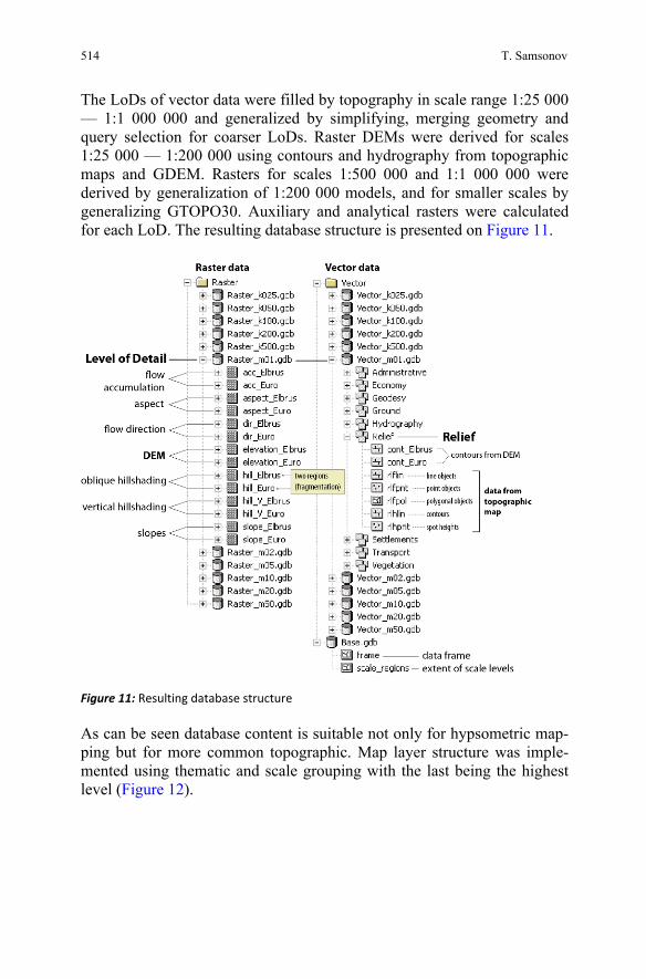
The LoDs of vector data were filled by topography in scale range 1:25 000 — 1:1 000 000 and generalized by simplifying, merging geometry and query selection for coarser LoDs. Raster DEMs were derived for scales 1:25 000 — 1:200 000 using contours and hydrography from topographic maps and GDEM. Rasters for scales 1:500 000 and 1:1 000 000 were derived by generalization of 1:200 000 models, and for smaller scales by generalizing GTOPO30. Auxiliary and analytical rasters were calculated for each LoD. The resulting database structure is presented on Figure 11.
Figure 11: Resulting database structure
As can be seen database content is suitable not only for hypsometric map-ping but for more common topographic. Map layer structure was imple-mented using thematic and scale grouping with the last being the highest level (Figure 12).
T. Samsonov
Multiscale Hypsometric Mapping 515
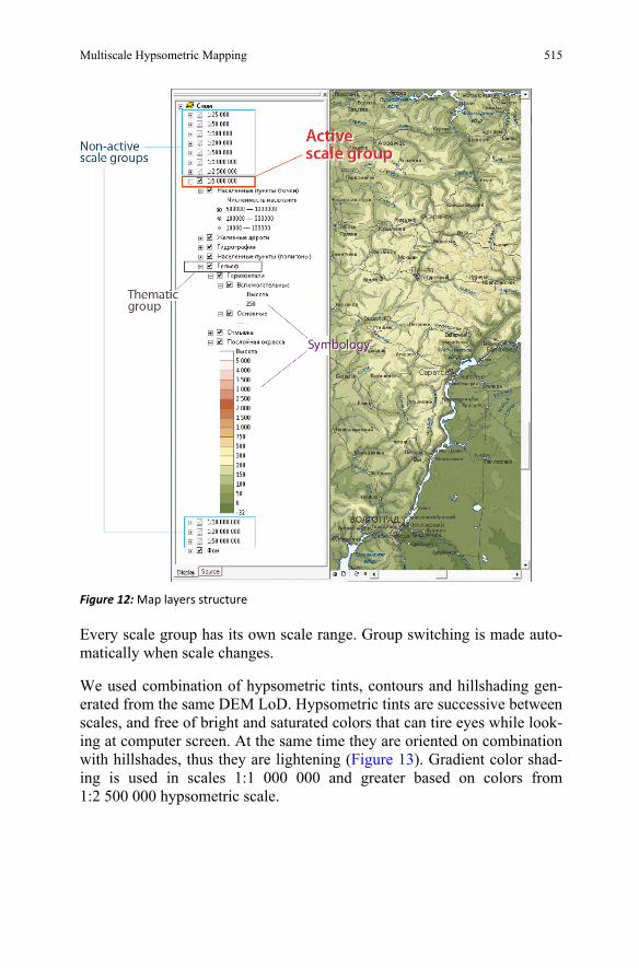
Figure 12: Map layers structure
Every scale group has its own scale range. Group switching is made auto-matically when scale changes.
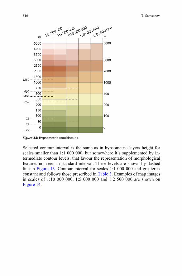
We used combination of hypsometric tints, contours and hillshading gen-erated from the same DEM LoD. Hypsometric tints are successive between scales, and free of bright and saturated colors that can tire eyes while look-ing at computer screen. At the same time they are oriented on combination with hillshades, thus they are lightening (Figure 13). Gradient color shad-ing is used in scales 1:1 000 000 and greater based on colors from 1:2 500 000 hypsometric scale.
516
Figure 13: Hypsometric «multiscale»
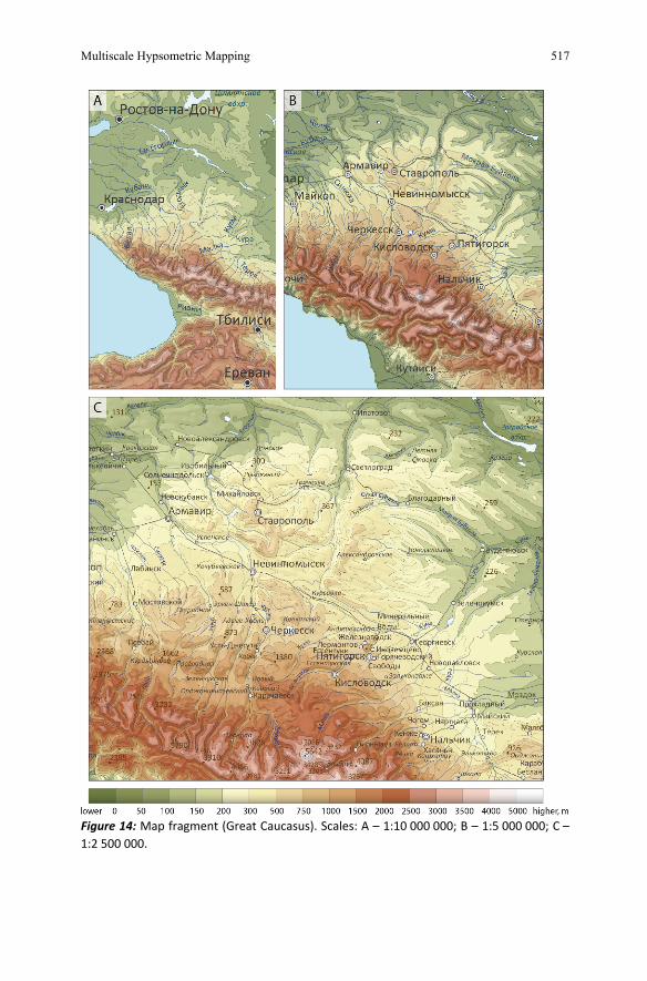
Selected contour interval is the same as in hypsometric layers height for scales smaller than 1:1 000 000, but somewhere it’s supplemented by in-termediate contour levels, that favour the representation of morphological features not seen in standard interval. These levels are shown by dashed line in Figure 13. Contour interval for scales 1:1 000 000 and greater is constant and follows those prescribed in Table 3. Examples of map images in scales of 1:10 000 000, 1:5 000 000 and 1:2 500 000 are shown on Figure 14.
T. Samsonov
Multiscale Hypsometric Mapping 517
Figure 14: Map fragment (Great Caucasus). Scales: A – 1:10 000 000; B – 1:5 000 000; C – 1:2 500 000.
518
4- Conclusion and future plans
Multiscale mapping has got a lot of attention during the last years, thanks to the growing interest in visual aspects of multiple representations. How-ever surprisingly few works can be found that investigate relief representa-tion as an element of multiscale maps. In this paper we presented methodology that provides representation and generalization of relief on multiscale hypsometric maps. Proposed database structure takes mapping scales into account. Developed algorithm for DEM generalization proved to be efficient in middle and small scales of mapping. It preserves major relief forms, slope profiles and structure lines although not being free of shortcomings. We also pointed out some rules of relief graphical represen-tation in multiscale mapping environment.
We believe that the most promising area to improve our methodology is the development and incorporation of real-time methods to control relief representation not only in fixed set of scales but in any scale within map scale range. This would lead to reduction of number of database LoDs, truly scale-correspondent and continuously changing image detailisation, and ability to interpolate symbology between scales.
Acknowledgments
This research was supported by RFFI grant #08-05-00126-а, Nauchnyie Shkoly grant NS-3405.2010.5 and Munobrnauki RF grant GK#14.740.11.0200. Author would like to thank pro-fessor Alexander Berlyant and professor Irina Lurie for their helpful and valuable notes.
References
Ai T (2007) The drainage network extraction from contour lines for contour line generalization. ISPRS Journal of Photogrammetry & Remote Sensing, 62, pp. 93–103.
Ai T, Li J (2010) A DEM generalization by minor valley branch detection and grid filling. ISPRS Journal of Photogrammetry and Remote Sensing, Volume 65, Issue 2, March 2010, pp. 198-207
Bédard Y, Bernier E (2002) Supporting Multiple Representations with Spatial View Manage-ment and the Concept of VUEL, Joint Workshop on Multi-Scale Representations of Spatial
T. Samsonov
Multiscale Hypsometric Mapping 519
Data, ISPRS WG IV/3, ICA Com. on Map Generalization. Ottawa, CANADA, July 7th-8th, 2002.
Bernardin T et al (2010) Crusta: A new virtual globe for real-time visualization of sub-meter digital topography at planetary scales. Computers and Geosciences, doi:10.1016/ j.cageo.2010.02.006.
Buttenfield B (1993) Research Initiative 3: Multiple Representations. Closing Report, National Center for Geographic Information and Analysis, Buffalo.
Brewer CA, Buttenfield BP (2009) Mastering map scale: balancing workloads using display and geometry change in multi-scale mapping. Geoinformatica, DOI 10.1007/s10707-009-0083-6, 19 pp.
Cecconi A, Weibel L, Barrault M (2004) Improving Automated Generalisation for On-Demand Web Mapping by Multiscale Databases. Symposium on Geospatial Thory, Processing and Applications, Ottawa.
Clarke KC (1988) Scale-Based Simulation of Topographic Relief Cartography and Geographic Information Science, 15(2), pp. 173-181(9).
Doytsher Y, Daliot S (2009) Producing Seamless Multi-Source Quality-Dependent Digital Terrain Models. Proceedings of 7th FIG Regional Conference, Hanoi, Vietnam, 15 pp.
Dragut L et al (2009) A Comparison of Methods to Incorporate Scale in Geomorphometry. Pro-ceedings of Geomorphometry 2009. Zurich, Switzerland, pp. 133–139.
Fan Q, Yang L, Hu P (2007) DEM generalization based on analysis of geometry and landscape context. In: Wang, Y., Li, J., Lei, B., Yang, J. (Eds.), MIPPR 2007. Vol. 6790, SPIE, Bellingham, Washington, pp. 679035
de Floriani L, Marzano P, Puppo E (1996) Multiresolution models for topographic surface. description, The Visual Computer, 12:317-345. p. 103-109
Frye C (2006) A Product Driven Approach to Designing a Multi-Purpose Multi-Scale GIS Base Map Database that Supports High Quality Mapping. Proceedings of AutoCarto 2006, Vancouver, 17 pp.
Imhof E (1982) Cartographic Relief Presentation. Berlin, Walter der Gruyter, 416 p. Jenny B, Jenny H and Räber S (2008) Map design for the Internet. In: M. P. Peterson (editor),
International Perspectives on Maps and the Internet, Berlin Heidelberg New York: Springer, p. 31-48.
Jones CB et al (1996) Database design for a Multi-scale spatial information system. Int. Journal of GIS, vol. 10(8), 1996, pp. 901–920.
Jordan G (2007) Adaptive smoothing of valleys in DEMs using TIN interpolation from ridge elevations: an application to morphotectonic aspect analysis. Computers & Geosciences 33, pp. 573–585.
Leonowicz AM, Jenny B and Hurni L (2009) Automatic generation of hypsometric layers for small-scale maps. Computers & Geosciences, №35, p. 2074–2083.
Leonowicz AM, Jenny B and Hurni L (2010) Automated reduction of visual complexity in small-scale relief shading. Cartographica, 45-1, p. 64–74.
Li Z (2007) Algorithmic Foundation of multi-scale spatial representation. CRC Press, 310 p. Loon JC (1978) Cartographic Generalization of Digital Terrain Models. Dissertation Paper, Ann
Arbor: University Microfilms International, 199 pp. Muller JC, Lagrange JP, Weibel R (1995) GIS and Generalization: Methodology and Practice. —
Taylor & Francis, London, UK. O'Callaghan JF, Mark DM (1984) The extraction of drainage networks from digital elevation
data. Computer Vision, Graphics, and Image Processing 28, 323–344. Peled A, Loon JC and Bossler JD (1989) ‘Producing Intermediate Contours from Digitized Con-
tours’, The American Cartographer, 16, 191–200. Wang Zh, Li Q, Yang B (2008) Multi-Resolution Representation of Digital Elevation Models
With Topographical Features Preservation. The International Archives of the Photogram-metry, Remote Sensing and Spatial Information Sciences. Vol. XXXVII. Part B6b. Beijing.

520
Weibel R (1987) An Adaptive Methodology for Automated Relief Generalization. Proceedings of Auto-Carto 8, Baltimore, Maryland, USA, pp. 42–49.
Wood J (1996) Scale-based Characterization of Digital Elevation Models. Innovations in GIS (3), CRC Press, pp. 163–175.
Wu F (2000) A Model for Multi-scale Handling and Representation of Relief Based on Wavelet Analysis. Proceeding of the 3th surveying and mapping workshop across strait, Hong Kong, pp. 435–441.
Zakšek K, Podobnikar T (2005) An effective DEM generalization with basic GIS operations. 8th ICA WORKSHOP on Generalisation and Multiple Representation. A Coruńa, July 7-8th.
Zarutskaya IP (1958) Metody sostavleniya reliefa na gipsometricheskikh kartakh (Methods of re-lief representation on hypsometric maps). Moskva, Iztatelstvo geodesicheskoy literatury. Moskva, 216 pp.
Zhang C, Pan M, Wu H, Xu H (2007) Study on simplification of contour lines preserving topo-logical coherence. Acta Scientiarum Naturalium Universitatis Pekinensis, 43(2), pp. 216-222
T. Samsonov


![New E-Books February 2015 - European University Institute · # 12 Advances in Cartography and GIScience. Volume 2 [electronic resource] : Selection from ICC 2011, Paris Ruas, Anne](https://img.pdfslide.us/doc/110x75/5ec84694d0cd7c3a730fb3fc/new-e-books-february-2015-european-university-institute-12-advances-in-cartography.jpg)