Embed Size (px)
Citation preview
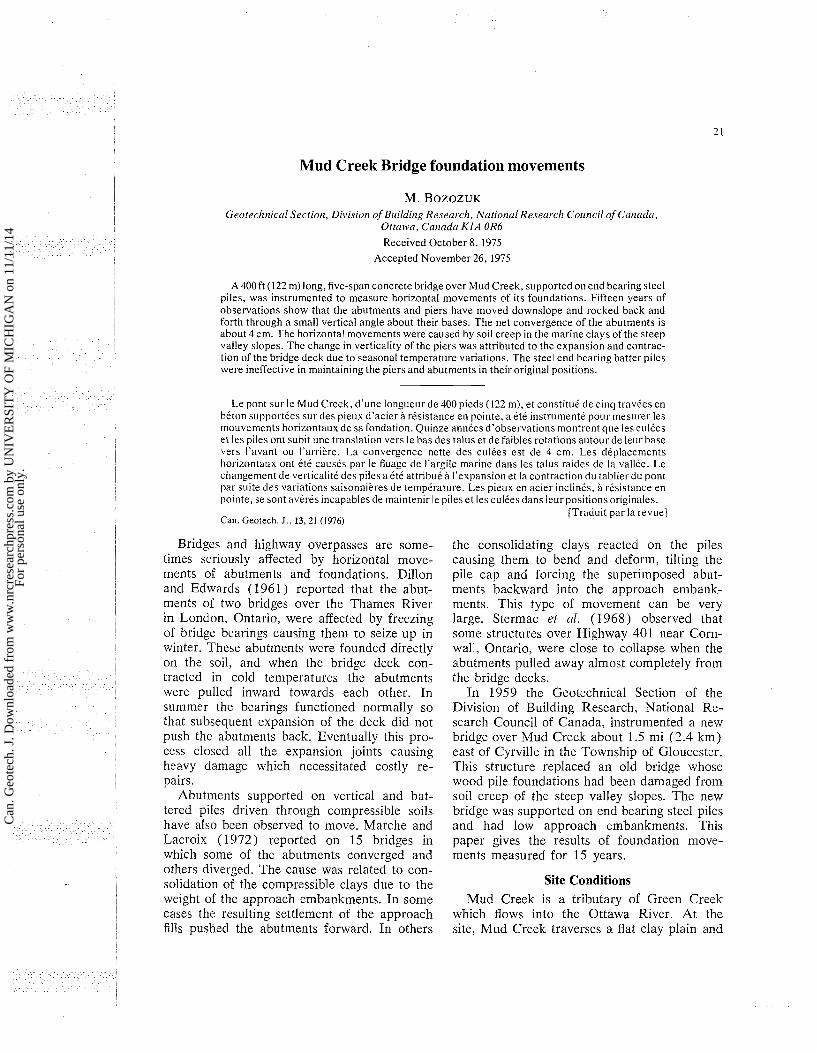
Mud Creek Bridge foundation movements
M. B o z o z u ~ Geotechnical Section, Division of Blrilding Research, Nrctiotzcll Research Council of Cmada,
Ottuwcr, Cnnndn KIA OR6
Received October 8, 1975 Accepted November 26, 1975
A 400ft (122 m) long, five-span concrete bridge over Mud Creek, supported on end bearing steel piles, was instrumented to measure horizontal movements of its foundations. Fifteen years of observations show that the abutments and piers have moved downslope and rocked back and forth through a small vertical angle about their bases. The net convergence of the abutments is about 4 cm. The horizontal movements were caused by soil creep in the marine clays of the steep valley slopes. The change in verticality of the piers was attributed to the expansion and contrac- tion of the bridge deck due to seasonal temperature variations. The steel end bearing batter piles were ineffective in maintaining the piers and abutments in their original positions.
Le pont sur le Mud Creek, d'une longueur de 400 pieds (122 m), et constitue de cinq travCes en beton supportkes surdes pieux d'acier B resistance en pointe, a etC instrumente P O L I ~ mesurer les mouvements horizontaux de sa fondation. Quinze annees d'observations montrent q ~ l e les culees et les piles ont subit une translation vers le bas des talus et de faibles rotations autour de leur base vers I'avant ou I'arriere. La convergence nette des culees est de 4 cm. Les dkplacements horizontaux ont Cte causes par le fluage de I'argile marine dans les talus raides de la vallee. Le changement de verticalit6 des piles a Cte attribue B I'expansion et la contraction d t ~ tablier du pont par s ~ ~ i t e des variations saisonnieres de temperature. Les pieux en acier inclines, i resistance en pointe, se sont averCs incapables de maintenir le pileset les culCesdans let~rpositionsoriginales.
[Traduit par la revue] Can. Geotech. J., 13,21 (1976)
Bridges and highway overpasses are some- times seriously affected by horizontal move- ments of abutments and foundations. Dillon and Edwards (1961 ) reported that the abut- ments of two bridges over the Thames River in London, Ontario, were affected by freezing of bridge bearings causing them to seize up in winter. These abutments were founded directly on the soil, and when the bridge deck con- tracted in cold temperatures the abutments were pulled inward towards each other. In summer the bearings functioned normally so that subsequent expansion of the deck did not push the abutments back. Eventually this pro- cess closed all the expansion joints causing heavy damage which necessitated costly re- pairs.
Abutments supported on vertical and bat- tered piles driven through compressible soils have also been observed to move. Marche and Lacroix (1972) reported on 15 bridges in which some of the abutments converged and others diverged. The cause was related to con- solidation of the compressible clays due to the weight of the approach embankments. In some
the consolidating clays reacted on the piles causing them to bend and deform, tilting the pile cap and forcing the superimposed abut- ments backward into the approach embank- ments. This type of movement can be very large. Stermac et 01. (1968) observed that some structures over Highway 401 near Corn- wall, Ontario, were close to collapse when the abutments pulled away almost completely from the bridge decks.
In 1959 the Geotechnical Section of the Division of Building Research, National Re- search Council of Canada, instrumented a new bridge over Mud Creek about 1.5 mi (2.4 km) east of Cyrville in the Township of Gloucester. This structure replaced an old bridge whose wood pile foundations had been damaged from soil creep of the steep valley slopes. The new bridge was supported on end bearing steel piles and had low approach embankments. This paper gives the results of foundation move- ments measured for 15 years.
Site Conditions Mud Creek is a tributary of Green Creek
cases the resulting settlement of the approach which flows into the Ottawa River. At the fills pushed the abutments forward. In others site, Mud Creek traverses a flat clay plain and
Can
. Geo
tech
. J. D
ownl
oade
d fr
om w
ww
.nrc
rese
arch
pres
s.co
m b
y U
NIV
ER
SIT
Y O
F M
ICH
IGA
N o
n 11
/11/
14Fo
r pe
rson
al u
se o
nly.
CAN. GEOTECH. J. VOL. 13, 1976
1 S O I L P R O F I L E
O E S I C C A T E O , S T I F F ,
GREY SILTY C L A Y
BLACK M O T T L I N G
VERY S E N S I T I V E S I L T Y , SANDY GREY CLAY W I T H C O N S I D E R A B L E BLACK Y O T T L l H G
S I L T . S A N O AND C L A Y
BEDROCK
9 0
N A T E R C O N T E N T , %
2 0 1 0 6 0 8 0
" P
- ., "L
/
;\a - b-. 2
H 8 i
H 3
FT $ 0
=NATURAL WATER CONTENT
WP'PLASTIC L I M I T
r L = L I P U I D L I M I T
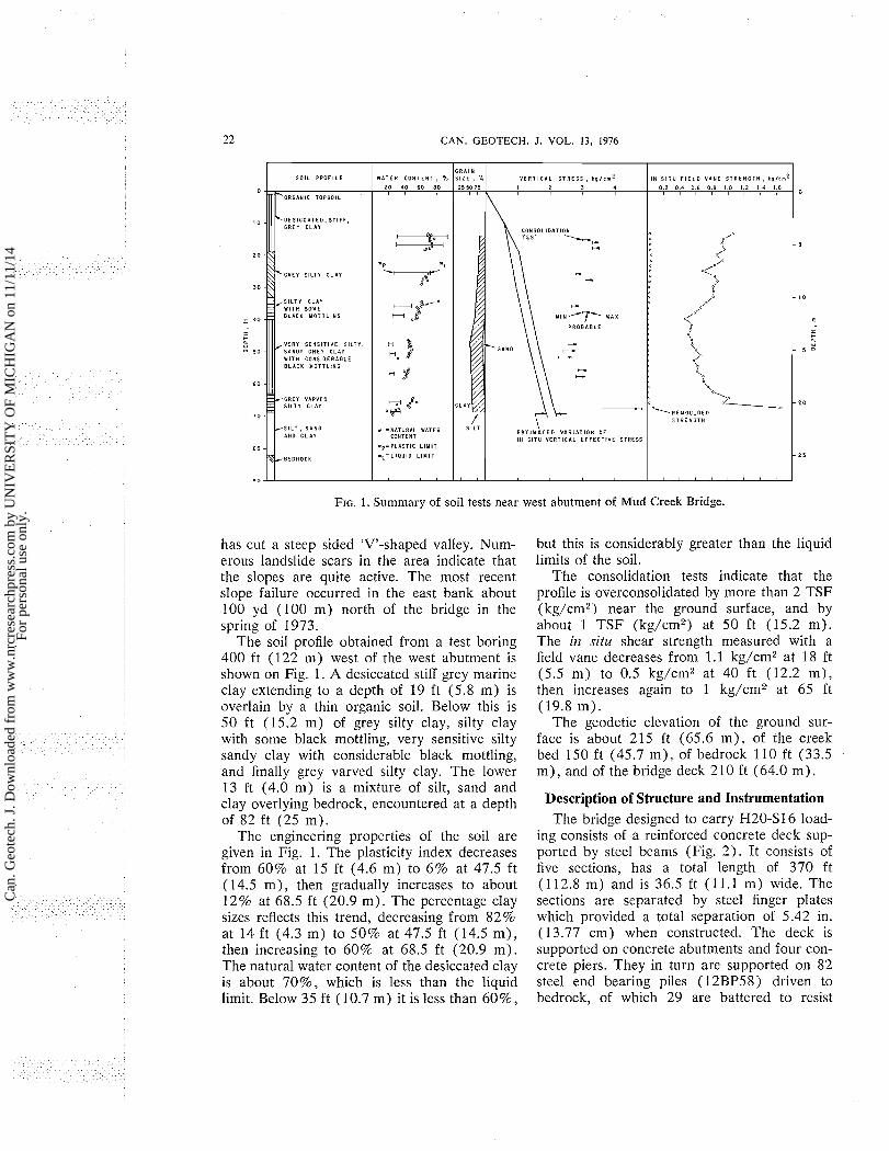
FIG. 1. Summary of soil tests near west abutment of Mud Creek Bridge.
R A I N I Z E , %
25 5 0 75
has cut a steep sided 'V'-shaped valley. Num- erous landslide scars in the area indicate that the slopes are quite active. The most recent slope failure occurred in the east bank about 100 yd (100 m) north of the bridge in the spring of 1973.
The soil profile obtained from a test boring 400 ft (122 m) west of the west abutment is shown on Fig. 1. A desiccated stiff grey marine clay extcnding to a depth of 19 ft (5.8 m) is ovcrlain by a thin organic soil. Below this is 50 ft (15.2 m) of grey silty clay, silty clay with some black mottling, very sensitive silty sandy clay with considerable black mottling, and finally grey varved silty clay. The lower 13 ft (4.0 m) is a mixture of silt, sand and clay overlying bedrock, cncountered at a depth of 82 ft (25 m).
The engineering properties of the soil are given in Fig. 1. The plasticity index decreases from 60% at 15 ft (4.6 m) to 6 % at 47.5 ft ( 14.5 m) , then gradually increases to about 12% at 68.5 ft (20.9 m). The percentage clay sizes reflects this trend, decreasing from 82% at 14 ft (4.3 m) to 50% at 47.5 ft (14.5 m) , then increasing to 60% at 68.5 ft (20.9 m) . The natural water content of the desiccated clay is about 70%, which is less than the liquid limit. Below 35 ft (10.7 m) it is less than 60%,
but this is considerably greater than the liquid limits of the soil.
The consolidation tests indicate that the profile is overconsolidated by more than 2 TSF (kg/cm2) near the ground surface, and by about 1 TSF (kg/cm2) at 50 ft (15.2 m) . The in situ shear strength measured with a field vane decreases from 1.1 kg/cm2 at 18 ft (5.5 m) to 0.5 kg/cm2 at 40 ft (12.2 m), then increases again to 1 kg/cm2 at 65 ft (19.8 m).
The geodetic elevation of the ground sur- face is about 215 ft (65.6 m) , of the creek bed 150 ft (45.7 m) , of bedrock 110 ft (33.5 m) , and of the bridge deck 2 10 ft (64.0 m) .
\ '
V E R T I C A L S T R E S S , k s / i m 2 1 2 3 4
Description of Structure and Instrumentation Thc bridge designed to carry H20-S16 load-
ing consists of a reinforced concrete deck sup- ported by steel beams (Fig. 2 ) . It consists of five sections, has a total length of 370 ft (1 12.8 m) and is 36.5 ft ( 1 1.1 m) wide. The sections are scparated by steel finger plates which provided a total separation of 5.42 in. (13.77 cm) when constructed. The deck is supportcd on concrete abutments and four con- crete piers. They in turn are supported on 82 steel end bearing piles (12BP58) driven to bcdrock, of which 29 are battered to rcsist
I N S l T U F I E L D V A N E S T R E N G T H . k p / r m 0 . 2 0 .4 0 . 6 0 . 0 1.0 1 2 1 . 4 1.6
Can
. Geo
tech
. J. D
ownl
oade
d fr
om w
ww
.nrc
rese
arch
pres
s.co
m b
y U
NIV
ER
SIT
Y O
F M
ICH
IGA
N o
n 11
/11/
14Fo
r pe
rson
al u
se o
nly.
BOZOZUK
PILE F O U N D A T I O N S
f- S I D E W A L K I omP*$
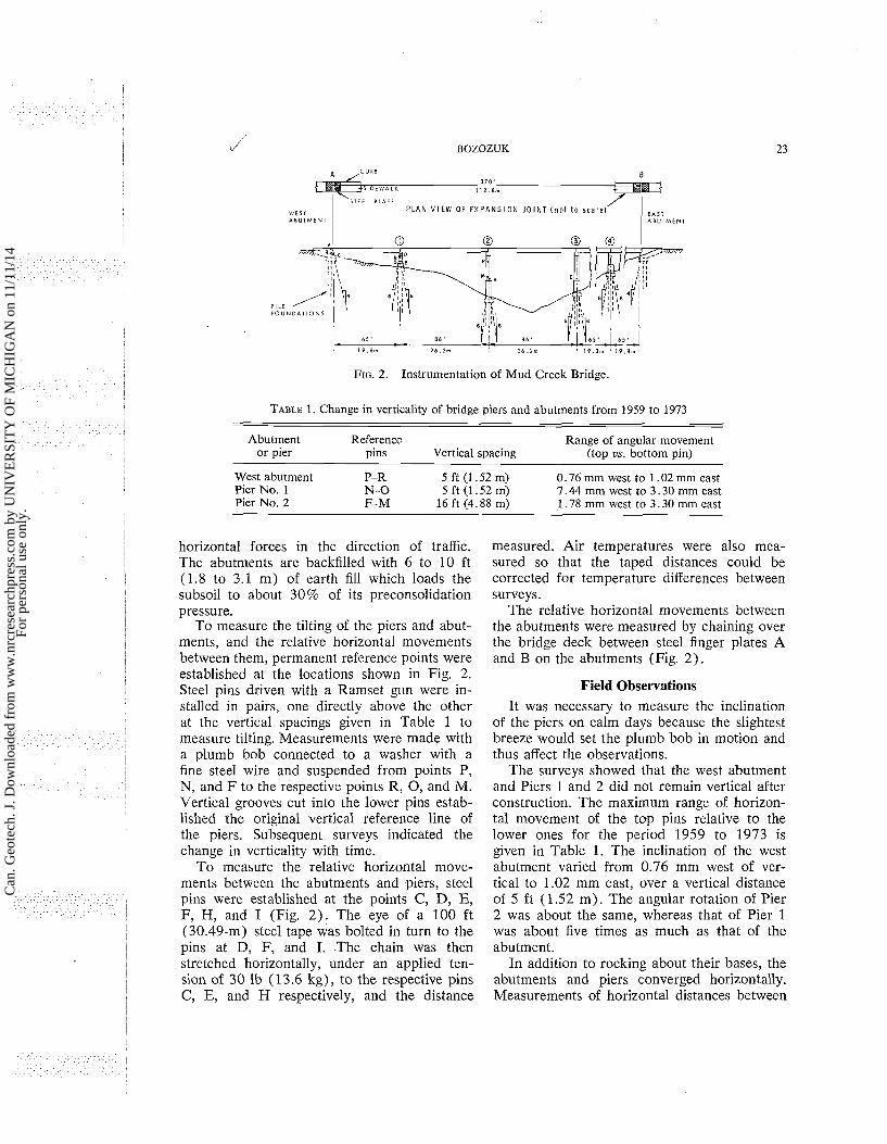
FIG. 2. Instrumentation of Mud Creek Bridge.
ViES l A B U l M E N l
TABLE 1. Change in verticality of bridge piers and abutments from 1959 to 1973
S l E E L P L A I E P L A N V I E W OF E X P A N S I O N J O I N T ( n o t to s c a l e ) 1 EAST
A B U T M E N T
Abutment Reference Range of angular movement or pier pins Vertical spacing (top us. bottom pin)
West abutment P-R 5 ft (1.52 m) 0.76 mm west to 1 .02 mm east Pier No. 1 N-0 5ft(1.52m) 7.44 mm west to 3.30 mm east Pier No. 2 F-M 16 ft (4.88 m) 1.78 mm west to 3.30 mm east
horizontal forces in the direction of traffic. The abutments are backfilled with 6 to 10 ft (1.8 to 3.1 m) of earth fill which loads the subsoil to about 30% of its preconsolidation pressure.
To measure the tilting of the piers and abut- ments, and the relative horizontal movements between them, permanent reference points were established at the locations shown in Fig. 2. Steel pins driven with a Ramset gun were in- stalled in pairs, one directly above the other at the vertical spacings given in Table 1 to measure tilting. Measurements were made with a plumb bob connected to a washer with a fine steel wire and suspended from points P, N, and F to the respective points R, 0, and M. Vertical grooves cut into the lower pins estab- lished the original vertical reference line of the piers. Subsequent surveys indicated the change in verticality with time.
To measure the relative horizontal move- ments between the abutments and piers, steel pins were established at the points C, D, E, F, H, and I (Fig. 2) . The eye of a 100 ft (30.49-m) steel tape was bolted in turn to the pins at D, F, and I. The chain was then stretched horizontally, under an applied ten- sion of 30 lb (1 3.6 kg), to the respective pins C, E, and H respectively, and the distance
measured. Air temperatures were also mea- sured so that the taped distances could be corrected for temperature differences between surveys.
The relative horizontal movements between the abutments were measured by chaining over the bridge deck between steel finger plates A and B on the abutments (Fig. 2 ) .
Field Observations It was necessary to measure the inclination
of the piers on calm days because the slightest breeze would set the plumb bob in motion and thus affect the observations.
The surveys showed that the west abutment and Piers 1 and 2 did not remain vertical after construction. The maximum range of horizon- tal movement of the top pins relative to the lower ones for the period 1959 to 1973 is given in Table 1. The inclination of the west abutment varied from 0.76 mm west of ver- tical to 1.02 mm east, over a vertical distance of 5 f t (1.52 m). The angular rotation of Pier 2 was about the same, whereas that of Pier 1 was about five times as much as that of the abutment.
In addition to rocking about their bases, the abutments and piers converged horizontally. Measurements of horizontal distances between
Can
. Geo
tech
. J. D
ownl
oade
d fr
om w
ww
.nrc
rese
arch
pres
s.co
m b
y U
NIV
ER
SIT
Y O
F M
ICH
IGA
N o
n 11
/11/
14Fo
r pe
rson
al u
se o
nly.
1, 24 J
CAN. GEOTECH. J. VOL. 13, 1976
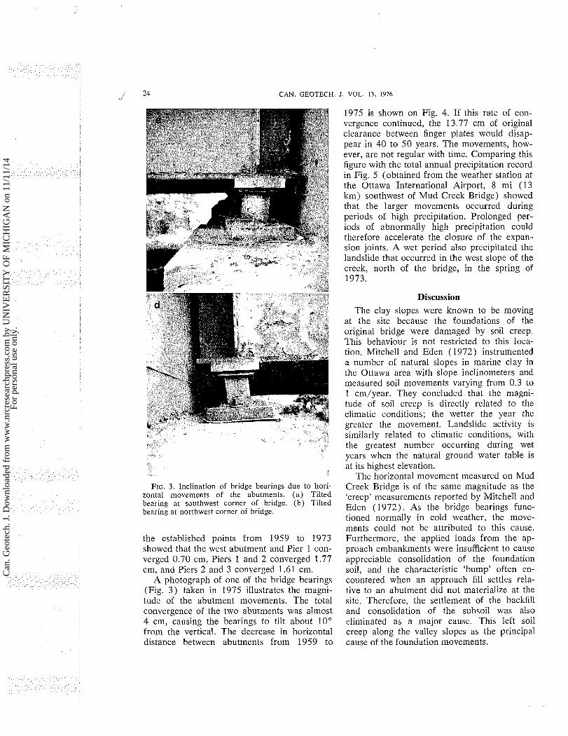
FIG. 3. Inclination of bridge bearings due to hori- zontal movements of the abutments. ( a ) Tilted bearing at southwest corner of bridge. (b ) Tilted bearing at northwest corner of bridge.
the established points from 1959 to 1973 showed that the west abutment and Pier 1 con- verged 0.70 cm, Piers 1 and 2 converged 1.77 cm, and Piers 2 and 3 converged 1.61 cm.
A photograph of one of the bridge bearings (Fig. 3 ) taken in 1975 illustrates the magni- tude of the abutment movements. The total convergence of the two abutments was almost 4 cm, causing the bearings to tilt about 10" from the vertical. The decrease in horizontal distance between abutments from 1959 to
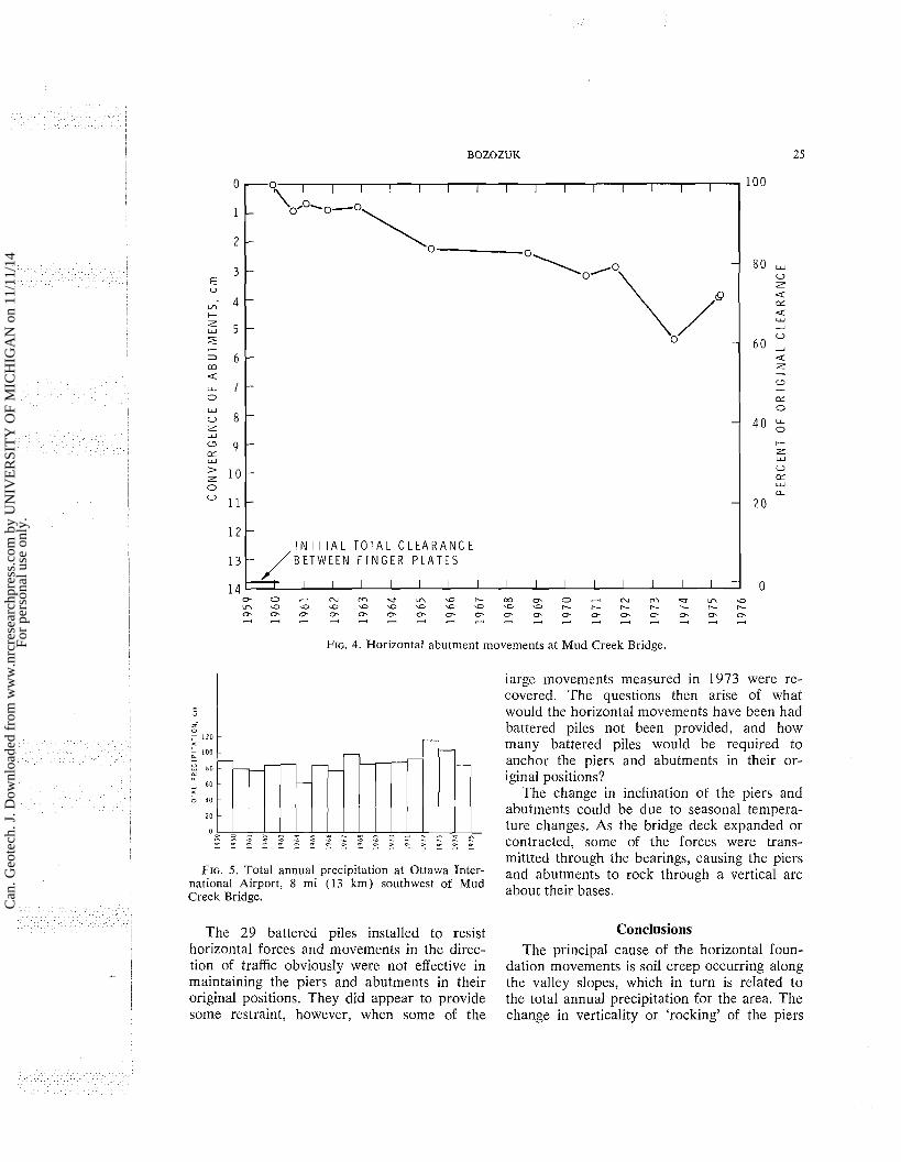
1975 is shown on Fig. 4. If this rate of con- vergence continued, the 13.77 cm of original clearance between finger plates would disap- pear in 40 to 50 years. The movements, how- ever, are not regular with time. Comparing this figure with the total annual precipitation record in Fig. 5 (obtained from the weather station at the Ottawa International Airport, 8 mi (13 km) southwest of Mud Creek Bridge) showed that the larger movements occurred during periods of high precipitation. Prolonged per- iods of abnormally high precipitation could therefore accelerate the closure of the expan- sion joints. A wet period also precipitated the landslide that occurred in the west slope of the creek, north of the bridge, in the spring of 1973.
Discussion The clay slopes were known to be moving
at the site because the foundations of the original bridge were damaged by soil creep. This behaviour is not restricted to this loca- tion. Mitchell and Eden ( 1972) instrumented a number of natural slopes in marine clay in the Ottawa area with slope inclinometers and measured soil movements varying from 0.3 to 1 cm/year. They concluded that the magni- tude of soil creep is directly related to the climatic conditions; the wetter the year the greater the movement. Landslide activity is similarly related to climatic conditions, with the greatest number occurring during wet years when the natural ground water table is at its highest elevation.
The horizontal movement measured on Mud Creek Bridge is of the same magnitude as the 'creep' measurements reported by Mitchell and Eden (1972). As the bridge bearings func- tioned normally in cold weather, the move- ments could not bc attributed to this cause. Furthermore, the applied loads from the ap- proach embankments were insufficient to cause appreciable consolidation of the foundation soil, and the characteristic 'bump' often en- countered when an approach fill settles rela- tive to an abutment did not materialize at the site. Therefore, the settlement of the backfill and consolidation of the subsoil was also eliminated as a major cause. This left soil creep along the valley slopes as the principal cause of the foundation movements.
Can
. Geo
tech
. J. D
ownl
oade
d fr
om w
ww
.nrc
rese
arch
pres
s.co
m b
y U
NIV
ER
SIT
Y O
F M
ICH
IGA
N o
n 11
/11/
14Fo
r pe
rson
al u
se o
nly.
BOZOZUK 25
FIG. 4. Horizontal abutment movements at Mud Creek Bridge.
largc movements measured in 1973 were re- covered. The questions then arise of what would the horizontal movements have been had battered piles not been provided, and how many battered piles would be required to anchor the piers and abutments in their or- iginal positions?
The change in inclination of the piers and abutments could be due to seasonal tempera- ture changes. As the bridge deck expanded or
e. - - a. - - 2 2 2 f S $ Z 1 5 E E K 2 E ? contracted, some of the forces were trans- mittted through the bearings, causing the piers
FIG. 5. Total annual precipitation a t Ottawa Inter- and abutments to rock through a vertical arc national Airport, 8 mi (13 km) southwest of Mud Creek Bridge. about thcir bases.
The 29 battered piles installed to resist Conclusions horizontal forces and movements in the direc- The principal cause of the horizontal foun- tion of traffic obviously were not effective in dation movements is soil creep occurring along maintaining the piers and abutments in their the valley slopes, which in turn is related to original positions. They did appear to provide the total annual precipitation for the area. The some restraint, however, when some of the change in verticality or 'rocking' of the piers
Can
. Geo
tech
. J. D
ownl
oade
d fr
om w
ww
.nrc
rese
arch
pres
s.co
m b
y U
NIV
ER
SIT
Y O
F M
ICH
IGA
N o
n 11
/11/
14Fo
r pe
rson
al u
se o
nly.
26 CAN. GEOTECH. J. VOL. 13. 1976
and abutments is probably due to the expan- sion and contraction of the bridge deck caused by seasonal temperature changes.
End bearing batter piles were not entirely effective in maintaining the piers and abut- ments in their original positions.
Acknowledgments The Roads Department of the Regional
Municipality of Ottawa-Carleton provided the opportunity for performing the observations, and the paper is published with their permis- sion. Thanks are due to the technical staff of the Geotechnical Section who carried out the surveys.
This paper is a contribution from the Divi- sion of Building Research, National Research Council of Canada, and is published with the approval of the Director of the Division.
DILLON, R. M. and EDWARDS, P. H. D. 1961. The Inspec- tion, repair and maintenance of highway bridges in Lon- don, Ontario. Eng. Inst. Can. Eng. J. 44(1 l), pp. 39-48.
MARCHE, R. and LACROIX, Y. 1972. StabilitC des culees de ponts Ctablies sur des pieux traversant une couche moile. Can. Geotech. J . 9(1), pp. 1-24.
MITCHELL, R. J . and EDEN, W. J . 1972. Measured move- ments of clay slopes in the Ottawa area. Can. J . Earth Sci. 9(8), pp. 1001-1013.
STERMAC, A. G., DEVATA, M., and SELBY, K. G. 1968. Unusual movements of abutments supported on end- bearing piles. Can. Geotech. J . 5(2), pp. 69-79.
Can
. Geo
tech
. J. D
ownl
oade
d fr
om w
ww
.nrc
rese
arch
pres
s.co
m b
y U
NIV
ER
SIT
Y O
F M
ICH
IGA
N o
n 11
/11/
14Fo
r pe
rson
al u
se o
nly.