Embed Size (px)
Citation preview
Mt Victoria to Cobham Drive Study - Technical Report –Policy & Planning
© NZ Transport Agency
www.nzta.govt.nz
May 2011
Revision 5
Copyright information
This publication is copyright © NZ Transport Agency. Material in it may be reproduced for personal or in-
house use without formal permission or charge, provided suitable acknowledgement is made to this
publication and the NZ Transport Agency as the source. Requests and enquiries about the reproduction of
material in this publication for any other purpose should be made to:
Manager, Information
NZ Transport Agency
PO Box 6995
Wellington 6141
The permission to reproduce material in this publication does not extend to any material for which the
copyright is identified as being held by a third party. Authorisation to reproduce material belonging to a
third party must be obtained from the copyright holder(s) concerned.
Disclaimer
The NZ Transport Agency has endeavoured to ensure material in this document is technically accurate and
reflects legal requirements. However, the document does not override governing legislation. The NZ
Transport Agency does not accept liability for any consequences arising from the use of this document. If
the user of this document is unsure whether the material is correct, they should refer directly to the
relevant legislation and contact the NZ Transport Agency.
More information …
NZ Transport Agency
May 2011
Revision 5
If you have further queries, call our contact centre on 0800 699 000 or write to us:
NZ Transport Agency
PO Box 6995
Wellington 6141
This document is available on the NZ Transport Agency’s website at www.nzta.govt.nz.
Page iii
Technical Report – Policy & Planning
April 2011
Record of amendment
Report reviewed by:
Name Position Signed/approved Date
Chris Hansen Statutory Approvals Manager 18/11/10
Chris Hansen Statutory Approvals Manager 01/03/11
Alistair Auburn Independent Peer Reviewer 29/03/11
Report approved by:
Name Position Signed/approved Date
Selwyn Blackmore NZTA Principal Planner May 2011
Details of Revision
Amendment
number
Description of change Effective date Updated by
Rev 1 NZTA comment 13/01/11
Rev 2 Preferred Option comment 28/02/11
Rev 3 NZTA comment 08/03/11
Rev 4 Revision in response to Independent Peer Reviewer comments 26/04/11
Rev 5 Final 23/05/11
Page iv
Technical Report –Policy & Planning
April 2011
Contents
Executive Summary .............................................................................................................................................. v
1 Introduction ......................................................................................................................................................................... 7
2 Key Policy & Planning Documents – Statutory and Non-statutory ................................................... 11
2.1 Overview ........................................................................................................................................ 11
2.2 National Legislation and Policy .................................................................................................... 11
2.3 Regional Policy & Plans ................................................................................................................. 14
2.4 Local/District Policy & Plans ......................................................................................................... 28
2.5 Other Strategic Documents .......................................................................................................... 34
2.6 Relevant Documents - Other Projects .......................................................................................... 35
3 Key Policy & Planning Themes/Issues .............................................................................................................. 37
3.1 Overview ........................................................................................................................................ 37
3.2 Key National Policy & Planning Themes/Issues ........................................................................... 37
3.3 Key Regional Policy & Planning Themes/Issues .......................................................................... 37
3.4 Key District Policy & Planning Themes/Issues ............................................................................ 38
3.5 Conclusion .................................................................................................................................... 39
Appendices .................................................................................................................................................................................................... 40
Appendix A - National Environmental Standard for Air Quality 2004 (Statutory) ........................................... 40
Appendix B - The Adelaide Road Framework .................................................................................................... 42
Appendix C- Kilbirnie Town Centre Draft Revitalisation Plan 2010 (Non-statutory) ....................................... 44
Appendix D - Relevant District Plan Provisions ................................................................................................ 45
Appendix E - Town Belt Management Plan ....................................................................................................... 57
Appendix F - Planning Issues for each Alignment ............................................................................................ 68
Page v
Technical Report –Policy & Planning
April 2011
Executive Summary
This Technical Report – Policy & Planning provides an overview of the policy and planning context that the
Mt Victoria to Cobham Drive Study should consider as part of the Scoping Report assessment of options. A
series of other Technical Reports should be read in conjunction with this report.
Key policy and planning themes/issues that apply generally to all road and tunnel alignment options in the
area include:
• Achieving an affordable, integrated, safe, responsive, and sustainable land transport system (Land Transport Management Act 2003 (LTMA))
• Assisting economic development; assisting safety and personal security; improving access, mobility
and reliability; protecting and promoting public health; and ensuring environmental sustainability
(LTMA)
• Recognition of New Zealand’s most essential routes – Roads of National Significance – in the
Government Policy Statement on Land Transport Funding 2009 (GPS) and in the Wellington Regional
Land Transport Strategy (WRLTS) – both documents recognise the Wellington Northern Corridor (and
the Mt Victoria to Cobham Drive project is part of that corridor)
• Recognition of the importance of the ‘Johnsonville to the airport – the growth spine’ in the Wellington
Regional Strategy 2007 as the ‘engine room’ of the regional economy and the directions given to the
Wellington Regional Policy Statement (RPS) and WRLTS in regards to more reliable transport links
between Ngauranga and the Airport and Port
• Maintaining or improving the opportunity to access active modes consistent with Greater Wellington Regional Council’s and Wellington City Council’s Cycling and Walking strategies as well as other policy
documents.
The assessment of policy and planning documentation relevant to the project has also identified specific
provisions that need to be considered when finalising and assessing the preferred option, as follows:
National considerations
At a national level, the National Environmental Standard (NES) for Air Quality contains mandatory technical
environmental regulations that override regional plan provision if the regional plan has not been updated
in accordance with the NES (which is the case in Wellington). The NES for Air Quality includes regulation of
the quality of air within numerous airsheds around New Zealand, including the Wellington CBD airshed
covering the city area. In this context, the NES for Air Quality requires that the combined discharge of
pollutants in the Wellington CBD airsheds not exceed the standards set out in the NES.
Regional considerations
At a regional level, the Wellington Regional Land Transport Strategy 2010 – 2040 (WRLTS) is the strategic
transport document that guides the development of the region’s transport system including public
transport, roads, walking, cycling and freight for the next 10 years and beyond. The WRLTS has been
informed by the Wellington Regional Strategy 2007, which specifically sought, amongst other things,
“more reliable transport links between Ngauranga and the airport and port”.
In particular, the WRLTS identifies the Ngauranga to Airport Corridor as part of the strategic transport
network and the Ngauranga to Wellington Airport Corridor (N2A) Plan 2008 has been prepared to
implement the strategic directions included in the WRLTS for this corridor. Both the WRLTS and the N2A
Plan identify the need to duplicate the Mt Victoria Tunnel and widen Ruahine Street (and Wellington Road
in N2A) as part of implementing the objectives and policies of the WRLTS.
Also, there are regional rules relating to activities that are likely to be important to most of the alignments
identified. These activities include soil disturbance; vegetation disturbance; discharges of contaminants to
air, land and water (including fresh water); and discharge of stormwater. It should be noted, however,
Page vi
Technical Report –Policy & Planning
April 2011
that some alignments may not be affected by these rules or be affected by other rules (e.g. if there is less
vegetation disturbance).
District considerations
At a district level, the Wellington City District Plan and Town Belt Management Plan identify issues, such as
heritage features, that are often specific to certain locations and therefore are specific to certain
alignments. Some of the key District Plan and Town Belt Management Plan issues that are likely to arise in
the context of this study include:
• A new designation is required as a new tunnel is not provided for in the District Plan, and works required to Ruahine Street/Wellington Road will be wider than the existing designation allows for
• The use of Town Belt Land for roading and legal mechanisms to acquire/remove land to the Town Belt
• Possible removal of, or effects on, heritage buildings
• Easements or leases may be needed for use of Town Belt land
• Earthworks land use consents.
Page 7
Technical Report – Policy & Planning
April 2011
1 Introduction
The Wellington Northern Corridor (Levin to Wellington Airport) has been identified by the Government as a
Road of National Significance (RoNS). Improvements to the Wellington Northern Corridor are required to
enhance safety, ease congestion and improve reliability of travel times along this section of the State
Highway network. The overall aim of these works is to enhance the long-term economic and
transportation performance of the Wellington region.
The Mt Victoria to Cobham Drive Project is part of the Wellington Urban RoNS which is one of eight
sections of the Wellington Northern Corridor. For this section, the New Zealand Transport Agency (NZTA)
has developed RoNS objectives that build on the relevant Government Policy Statement (GPS) intentions to:
support economic growth; reduce congestion; and improve safety (refer to the Statutory Approvals
Management Plan for details on the specific RoNS objectives).
The WRLTS is a strategic transport document that guides the development of the region’s transport
system including public transport, roads, walking, cycling and freight for the next 10 years and beyond.
The WRLTS recognises the Wellington RoNS programme and the priority on investments into infrastructure
that contribute to economic growth and productivity signalled by the Government in the Government
Policy Statement 2009 (GPS).
The WRLTS establishes objectives and policies to deliver an integrated land transport network that
supports the region’s people and prosperity, and requires Corridor Plans to be prepared for four key
corridors (including the Ngauranga to Airport Corridor). More reliable transport between Ngauranga and
the airport and port is a key local outcome sought by the Wellington Regional Strategy that informed the
directions included in the WRLTS. The Ngauranga to Wellington Airport (N2A) Corridor Plan 2008
addresses transport for the multi-modal corridor starting at the Ngauranga Merge and continuing through
the Wellington City CBD to Newtown (including the regional hospital), the Eastern Suburbs and Wellington
International Airport. It includes State Highway 1, major arterial routes, the railway line where the North
Island Main Trunk and the Wairarapa lines merge and through to Wellington City rail terminals, and key
routes for passenger transport, walking and cycling.
As part of the preparation of the N2A Corridor Plan, the Greater Wellington Regional Council (GWRC)
sought public comment on the directions proposed to address the issues facing this part of the transport
network. Support for the directions in the N2A Corridor Plan was widespread, and a clear mandate was
given to undertake feasibility studies, including (amongst other things):
• Improvement in walking and cycling facilities in Mt Victoria Tunnel
• Four laning of Ruahine Street and Wellington Road
• The duplication of the Mt Victoria Tunnel, considering in particular its relationship with the Basin
Reserve flyover and improved transport links from the airport to the CBD for freight, taxis and
public transport.
Taking into account the findings of the above feasibility studies, the N2A Corridor Plan required Scheme
Assessment Reports to be undertaken for (amongst other things) the four laning of Ruahine Street and
Wellington Road and for the duplication of Mt Victoria Tunnel.
NZTA has commissioned the Wellington Tunnel Alliance (WTA) to finalise preferred options for the route
from Mt Victoria to Cobham Drive through a Scoping Report and Scheme Assessment Report process, to
consult on the preferred options, select and design a preferred option, and to prepare documentation to
gain all necessary statutory approvals.
Page 8
Technical Report –Policy & Planning
April 2011
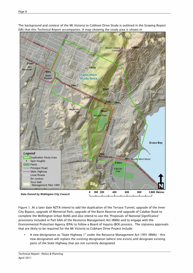
The background and context of the Mt Victoria to Cobham Drive Study is outlined in the Scoping Report
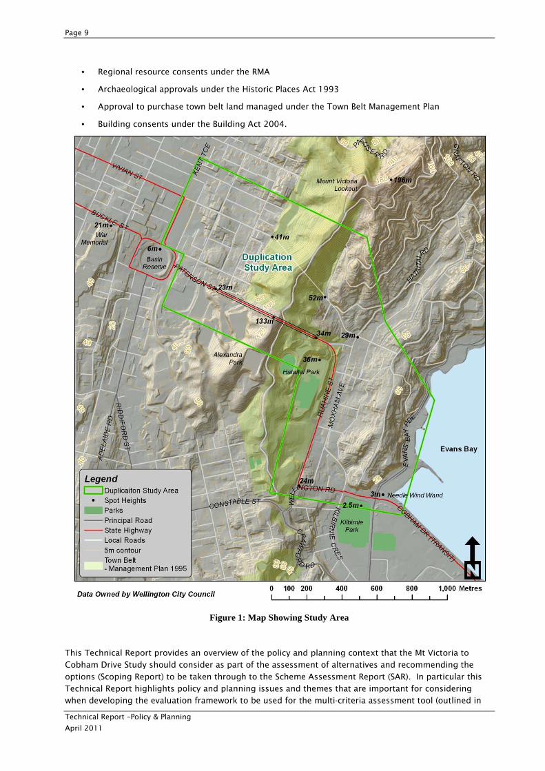
(SR) that this Technical Report accompanies. A map showing the study area is shown in
Figure 1. At a later date NZTA intend to add the duplication of the Terrace Tunnel, upgrade of the Inner
City Bypass, upgrade of Memorial Park, upgrade of the Basin Reserve and upgrade of Calabar Road to
complete the Wellington Urban RoNS and also intend to use the ‘Proposals of National Significance’
provisions included in Part 6AA of the Resource Management Act (RMA) and to engage with the
Environmental Protection Agency (EPA) to follow a Board of Inquiry (BOI) process. The statutory approvals
that are likely to be required for the Mt Victoria to Cobham Drive Project include:
• A new designation as “State Highway 1” under the Resource Management Act 1991 (RMA) – this
new designation will replace the existing designation (where one exists) and designate existing
parts of the State Highway that are not currently designated
Page 9
Technical Report –Policy & Planning
April 2011
• Regional resource consents under the RMA
• Archaeological approvals under the Historic Places Act 1993
• Approval to purchase town belt land managed under the Town Belt Management Plan
• Building consents under the Building Act 2004.
Figure 1: Map Showing Study Area
This Technical Report provides an overview of the policy and planning context that the Mt Victoria to
Cobham Drive Study should consider as part of the assessment of alternatives and recommending the
options (Scoping Report) to be taken through to the Scheme Assessment Report (SAR). In particular this
Technical Report highlights policy and planning issues and themes that are important for considering
when developing the evaluation framework to be used for the multi-criteria assessment tool (outlined in
Page 10
Technical Report –Policy & Planning
April 2011
the Technical Report – Evaluation Framework). This evaluation framework is used to assess options
identified through the ‘Blue Skies’ workshop and as part of the finalising of a short list of options included
in the Scoping Report (SR). The weighting of the importance of these policy and planning issues and
themes is a key factor when assessing alternatives. This Technical Report also informs the other technical
reports (listed below) that support the assessment of options and the preparation of the Scoping Report.
The SAR will recommend a preferred option to be taken through to detail design and for gaining statutory
approvals. The overarching policy framework relevant to this project is depicted in
Figure 2. These policy and planning documents are reviewed in Section 2 of this Report. Information on
additional analysis undertaken to date is provided in other Technical Reports supporting the SR. These
Technical Reports cover:
• Environmental issues
• Urban design and landscape issues
• Engineering and construction
• High level costings
• Traffic and transport planning
• The identification and evaluation of options (Evaluation Framework).
Page 11
Technical Report –Policy & Planning
April 2011
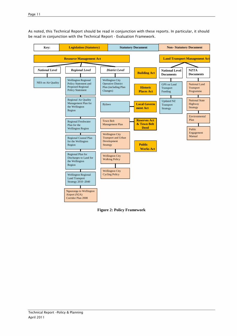
As noted, this Technical Report should be read in conjunction with these reports. In particular, it should
be read in conjunction with the Technical Report - Evaluation Framework.
Figure 2: Policy Framework
National Level
Resource Management Act
NES on Air Quality
Historic Places Act
Town Belt Management Plan
Regional Level District Level
Wellington Regional Land Transport Strategy 2010 -2040
Regional Air Quality Management Plan for the Wellington Region
Wellington Regional Policy Statement andProposed Regional Policy Statement
Regional Freshwater Plan for the Wellington Region
Regional Coastal Plan for the Wellington Region
Regional Plan for Discharges to Land for the Wellington Region
Wellington City Operative District Plan (including Plan Changes)
Bylaws
Wellington City Transport and Urban Development Strategy
Wellington City Cycling Policy
Wellington City Walking Policy
Non - Statutory Document
Land Transport Management Act
GPS on Land Transport Funding
Updated NZ Transport Strategy
Environmental Plan
National Land Transport Programme
National State Highway Strategy
Public Engagement Manual
NZTA Documents
Local Govern-ment Act
Statutory Document
Building Act
Reserves Act & Town Belt
Deed
Key:
National Level Documents
Legislation (Statutory)
Public Works Act
Ngauranga to WellingtonAirport (N2A) Corridor Plan 2008
Page 12
Technical Report –Policy & Planning
April 2011
2 Key Policy & Planning Documents – Statutory and Non-statutory
2.1 Overview
This review of policy and planning documents provides the context for the Mt Victoria to Cobham Drive
Study. This context has been important for the development of the evaluation framework (refer to Scoping
Report for details of the evaluation framework) for the high level Multi Criteria Assessment Tool (MCAT)
process to select options for more detailed assessment through the Scheme Assessment Report (SAR)
process. This context will also be relevant for the more detailed assessment of preferred option(s), and
for the preparation of statutory approvals documentation in accordance with the requirements of the RMA
ready for lodging with the EPA.
2.2 National Legislation and Policy
2.2.1 Statutory and Primary
The Land Transport Management Act 2003
The Land Transport Management Act 2003 (LTMA) provides the legal framework for managing and
funding land transport activities. The purpose of the LTMA is to contribute to achieving an affordable,
integrated, safe, responsive, and sustainable land transport system. It seeks to achieve this by:
• Providing an integrated approach to land transport funding and management through development
of a National Land Transport Strategy (NLTS); the regional land transport strategies; a Government
Policy Statement on land transport funding (GPS); and national and regional land transport
programmes
• Improving social and environmental responsibility in land transport funding, planning, and
management by defining the function and roles of the NZTA, regional councils and regional transport
committees for land transport planning, programming and funding
• Defining the function and roles of the NZTA with a broad land transport focus
• Improving long-term planning and investment in land transport
• Ensuring land transport funding is allocated in an efficient and effective manner
• Improving the flexibility of land transport funding by providing for alternative funding mechanisms.
The GPS, national and regional land transport strategies and land transport programmes must be prepared
to ensure they contribute to the purpose of the LTMA and the following five matters:
A. Assisting economic development
B. Assisting safety and personal security
C. Improving access and mobility
D. Protecting and promoting public health
E. Ensuring environmental sustainability.
Other matters that must be taken into account in these documents include: the relevant GPS; other
national and regional land transport strategies and programmes; national energy efficiency and
Page 13
Technical Report –Policy & Planning
April 2011
conservation strategy; national policy statement and regional policy statements and plans; regional public
transport plan; and likely funding from any source.
The NLTS must also include measurable targets to achieve the Crown’s outcomes and objectives in
relation to land transport in New Zealand over a period of at least 30 financial years. The Ministry of
Transport and the NZTA must take into account the national land transport strategy in exercising its
powers or performing its functions and duties.
Under the LTMA, options and alternatives must be given full consideration in the early stage of the project
and must not be inconsistent with the purpose of the LTMA.
Resource Management Act 1991
The Resource Management Act 1991 (RMA) is the primary environmental legislation in New Zealand with
the purpose of promoting the sustainable management of natural and physical resources, focusing on the
use of land, air and water. The RMA prescribes the content of a number of statutory documents and
details of the documents relevant to this project are included throughout this report. The Statutory
Approvals Management Plan for the Mt Victoria to Cobham Drive Study provides a more comprehensive
summary of the key provisions of the RMA relevant to the Project.
Of particular relevance to the Mt Victoria to Cobham Drive Study are the provisions included in Part 6AA
Proposals of National Significance. Recognition of the Wellington Northern Corridor as a RoNS means the
NZTA intend to use the process relating to proposals of national significance and the subsequent call-in
provisions to the EPA for gaining approvals for the Project. The Statutory Approvals Management Plan
(SAMP) accompanying this Technical Report provides detail on the assessment of the project against the
provisions contained in s.142 of the RMA.
Wellington (City) Town Belt Reserves Act 1908
The Wellington (City) Town Belt Reserves Act 1908 gives governance of the Town Belt land to the
Wellington City Council and outlines conditions and restrictions associated with leasing of Town Belt land.
It includes a schedule of Wellington Town Belt land. This Act is considered relevant to the study if any
town belt land is required for the preferred option.
Public Works Act 1981
The Public Works Act 1981 is administered by Land Information New Zealand and includes provisions for
the acquisition of land for public works. Should the NZTA require parts of the Town Belt land for the
project, it may request the Minister of Conservation to set apart public reserve land (Town Belt) for a
public work under Section 52 of the Public Works Act 1981. Land owner compensation may be required.
Government Policy Statement on Land Transport Funding 2009 (GPS)
The Government Policy Statement (GPS) is a key policy document developed and issued under the LTMA. It
details the government’s desired outcomes and funding priorities for the use of the National Land
Transport Fund to support activities in the land transport sector.
The GPS sets out the government’s priority for its investment in land transport to increase economic
productivity and growth in New Zealand. Investing in high quality infrastructure projects that support the
efficient movement of freight and people is seen as critical.
From its investment in land transport, government wishes to achieve:
• Efficient movement of freight and people
• Better value for money across all land transport activity classes and enhancing economic efficiency
of individual projects
• The objectives of the LTMA by contributing to an affordable, integrated, safe, responsive and
sustainable land transport system.
Page 14
Technical Report –Policy & Planning
April 2011
Two key initiatives are included in the GPS to support the investment in infrastructure: the creation of an
infrastructure portfolio to coordinate, motivate and overview infrastructure activity; and the listing of
seven Road of National Significance (RoNS) as a statement of national road development priorities. The
RoNS provides a focus for investment to achieve economic growth and productivity, and these are
considered to be the most essential routes that require significant development to reduce congestion,
improve safety and support economic growth.
The Wellington Northern Corridor (Levin to Wellington) – State Highway 1 is one of the seven listed RoNS.
The Mt Victoria to Cobham Drive Project is an important component of the Wellington Urban RoNS (one of
the eight parts of the Wellington Northern Corridor) and funding of the Project is given priority under the
GPS.
Historic Places Act 1993
The Historic Places Act 1993 (HPA) intends to promote the identification, protection, preservation, and
conservation of the historical and cultural heritage of New Zealand. The HPA establishes heritage orders
and covenants; procedures for applications relating to archaeological sites; the registration of historical
places/areas, wahi tapu, and wahi tapu areas; and charges the Historic Places Trust (HPT) to prepare policy
for historic places and conservation plans.
The provisions of the HPA and involvement of the HPT are relevant to the Mt Victoria to Cobham Drive
Study, as much of this part of Wellington City was settled pre-1900 and is of historical interest.
2.2.2 Statutory and Secondary
National Environmental Standard for Air Quality 2004 (NES)
The National Environmental Standard (NES) for Air Quality was released in 2004, with amendments made
in late 2004 and 2005. The NES for Air Quality contains mandatory technical environmental regulations.
They have the force of regulation and are implemented by agencies and parties with responsibilities under
the RMA. A review of the NES for Air Quality in terms of relevance to this Project is provided in 0.
Other Statutory and Secondary Documents
Other statutory primary and secondary documents have been reviewed as part of this study but are
considered not necessarily important to the development of the evaluation framework to assess the
options, thus are not included here. These include:
• Reserves Act 1977
• Energy Efficiency and Conservation Act 2000
• Public Transport Management Act
• The NZTA Statement of Intent
• National Land Transport Programme 2009-2012 (NLTP)
• New Zealand Energy Efficiency and Conservation Strategy (October 2007).
2.2.3 Non-Statutory and Primary
New Zealand Urban Design Protocol 2005
In March 2005, Transit New Zealand (now the NZ Transport Agency or the NZTA) became an early
signatory to the New Zealand Urban Design Protocol. NZTA’s commitment to the Protocol is embodied in
its Urban Design Policy which requires that urban design is considered at all stages of highway projects
from route selection through to detailed alignments and to the design of specific road components.
Page 15
Technical Report –Policy & Planning
April 2011
More specifically, NZTA’s Urban Design Policy is aimed at ensuring that:
• Roads fit in sensitively with the landform and the built, natural and community environments
through which they pass
• All systems of movement along and across the corridor are integrated into the design of projects
with good connections and access to communities; and
• The design contributes to the quality of public space and the road user’s experience.
The purpose of the Urban and Landscape Design Assessment (ULDA) is to demonstrate how the Mt
Victoria to Cobham Drive Study satisfies NZTA’s Urban Design Policy requirements.
The ULDA will give effect to NZTA’s Urban Design Policy by including:
• An appreciation of the policy and physical contexts to the route
• The identification of urban design issues and opportunities within the project or in the project’s
immediate surroundings
• Design objectives and principles to guide the development of specific aspects of the road
alignment and road components
• Setting a framework for further assessment at the Scheme Assessment Report (SAR) stage as a full
Urban Design and Landscape Framework is developed to inform the future detailed design of the
Project.
Other Non-Statutory and Primary Documents
Other non-statutory and primary documents have been reviewed as part of this study but are considered
not necessarily important to the development of the evaluation framework to assess the options, thus are
not included here. This includes the National State Highway Strategy 2007 (NSHS).
2.2.4 Non-Statutory and Secondary
Other Non-Statutory and Secondary Documents
Other non-statutory and secondary documents have been reviewed as part of this study but are considered
not necessarily important to the development of the evaluation framework to assess the options, thus are
not included here. These include:
• Environmental Plan 2005
• Getting There – On Foot, By Cycle 2005
• NZTA Planning Policy Manual 2007
• Public Engagement Manual 2008.
2.3 Regional Policy & Plans
2.3.1 Statutory and Primary
Regional Policy Statement 1995; Proposed Regional Policy Statement 2009
The Regional Policy Statement (RPS) is a statutory document prepared under the RMA and sets out
objectives for the region as a whole. The RPS signals to district councils where rules should be in
conjunction to achieving the regional objectives. The operative RPS is currently under review with the
proposed RPS notified in 2009.
Page 16
Technical Report –Policy & Planning
April 2011
The operative RPS has regional objectives relevant to the Project relating to: Iwi Environmental
Management; Freshwater; Soils and Minerals; Air; Ecosystems; Landscape and Heritage; Energy; and the
Built Environment and Transport. The proposed RPS has regional objectives relevant to the Project relating
to: Air Quality; Energy Infrastructure and Waste; Freshwater; Historic heritage; Landscapes; Regional Form
Design and Function; Resource Management with Tangata Whenua; and Soil and Minerals.
In particular, Objective 9 of the proposed RPS intends (among other things) to reduce greenhouse gas
emissions from transport through Policies 8 and 9. Policy 9 promotes travel demand management
through district plans and the RLTS. This policy is implemented through the RLTS and provides
information about travel demand management. This direction is important in informing the assessment of
options considered against the RLTS.
The RPS (operative and proposed) also set in place the provision for regional plans to regulate activities,
and in particular regional resource consents are likely for a number of activities associated with the
Project. These consents will be scoped at the SAR stage for the preferred option.
Wellington Regional Land Transport Strategy 2010 – 2040
The WRLTS is a strategic transport document that guides the development of the region’s transport
system including public transport, roads, walking, cycling and freight for the next 10 years and beyond.
The WRLTS recognises the Wellington RoNS programme and the priority on investments into infrastructure
that contribute to economic growth and productivity signalled by government in the Government Policy
Statement 2009 (GPS).
The WRLTS seeks to address key issues and pressures faced by the region including:
• Access to goods and services, employment
and amenities.
• Regional road safety, particularly for cyclists.
• Severe traffic congestion, particularly at peak
times.
• East-west connections between key transport
corridors and regional centres.
• The reliability of the transport network.
• Transport-related greenhouse gas emissions.
• Public transport capacity and mode share.
The strategy responds to the region’s projected economic and population growth and the need to manage
anticipated increases in travel demand.
The WRLTS objectives are to:
• Assist economic and regional development.
• Assist safety and personal security.
• Improve access, mobility and reliability.
• Protect and promote public health.
• Ensure environmental sustainability.
• Ensure that the Regional Land Transport
Programme is affordable for the regional
community.
The strategy identifies a number of key outcomes which the region seeks to achieve over the long term.
Outcomes have been given a hierarchical structure of ‘key outcomes’ and ‘related outcomes’ to clearly
signal priorities for the strategy over the next 30 years. Key outcomes of the strategy are consistent with
the former WRLTS, though the new WRLTS brings with it a new inter-regional outcome which is: ‘improved
safety, efficiency and reliability of strategic road, public transport and freight links to the north of the
region’. A series of targets has been developed out to 2020 for all of the strategy outcomes, and policies
have been developed to support these targets.
Implementation
The WRLTS establishes objectives and policies to deliver an integrated land transport network that
supports the region’s people and prosperity, and requires Corridor Plans to be prepared for four key
corridors, including the Ngauranga to Airport Corridor. A Corridor Plan defines the immediate priorities
for the corridor, and sets measures (improvement packages) to be implemented within 10 years, and
Page 17
Technical Report –Policy & Planning
April 2011
measures that may be implemented beyond the 10-year period. The Ngauranga to Wellington Airport
(N2A) Corridor Plan 2008 is reviewed in Section 2.3.3 below.
Development of a Regional Land Transport Programme (RLTP) is a legislative requirement and sits
alongside the WRLTS. The Programme sets out the priorities for projects and activities in the region with
estimated timing and costs. The review process for the Programme is every three years and will use an
agreed prioritisation tool, taking into account the strategic framework provided by the WRLTS.
One of the most significant features identified in the strategy to be progressed through the supporting
implementation documents is, “Progress on the key routes of national and regional significance (including
the State Highway 1 Wellington Northern Corridor Road of National Significance)”. The WRLTS signals that
the Implementation and Corridor Plans will need to be updated during their next scheduled review to
incorporate the strategic framework provided by the GPS and ensure the Wellington Northern Corridor
Road of National Significance programme is appropriately aligned.
Funding
The WRLTS must be developed with consideration to likely funding. The funding chapter summarises the
main sources of funding available to the region. The NZTA’s National Land Transport Programme sets out
the funding available to the Wellington region over the next three years, and GWRC’s Regional Land
Transport Programme details indicative funding for the next 10 years.
The NZTA has identified $2 billion will be spent on the Wellington Northern Corridor Road of National
Significance in the Wellington region.
Monitoring, evaluation and review
The strategy concludes with measures for monitoring, evaluating and reviewing the strategy (and
supporting implementation and corridor plans) to ensure it maintains relevance and delivers its vision and
objectives within a changing environment.
The chapter on funding specifically mentions duplication of the Mt Victoria Tunnel. This section states:
In December 2009 the Government announced its decision to invest over $2 billion dollars in the
Wellington Northern Corridor Road of National Significance (State Highway 1 from Levin to
Wellington International Airport). This will significantly transform the region’s roading network
over the period of this Strategy and deliver against a number of RLTS outcomes and policies.
This funding is targeted over three phases which include:
• Aotea Quay to Ngauranga improvements
• Basin Reserve upgrade
• Mount Victoria and Terrace Tunnel duplications
• Transmission Gully
• Sandhills Expressway (between MacKay’s and Levin).
The WRLTS also references the Ngauranga to Wellington Airport N2A Corridor Plan as being in line with
the project suite identified for the Wellington Northern Corridor Road of National Significance. The timing
of some of the projects has been brought forward by the NZTA; namely, the Mt Victoria and Terrace
Tunnel duplications and widening of Ruahine Street/Wellington Road. These timing changes will be taken
into account during the next review of this Corridor Plan.
Proposed Regional Public Transport Plan
Page 18
Technical Report –Policy & Planning
April 2011
Under the Public Transport Management Act (PTMA), the GWRC must, by resolution, adopt a Regional
Public Transport Plan (RPTP) and the PTMA specifies the requirements for RPTP. The GWRC is updating its
RPTP. The purpose of this plan is to:
• Specify how GWRC will give effect to the public transport aspects of the WRLTS; and
• Contribute to achieving an affordable, integrated, safe, responsive and sustainable land transport system.
The plan is a key tool in delivering one of the community outcomes set out in GWRC's 10-year Plan 2009-
2019: "a well-patronised public transport network that helps people get around the region easily and
reduces road congestion". The plan will set out the public transport objectives, policies and methods that
GWRC proposes to ensure the region can give effect to the WRLTS and achieve its outcomes. The plan will
primarily be an update and realignment of the existing plan to better support the design and development
of an integrated public transport network and to comply with current legislation and policies.
A four-layered public transport service approach is provided:
• A Rapid Transit Network (RTN) – a strategic public transport network that connects regionally significant centres – mostly rail but with buses linking through to Wellington Hospital and Wellington
Airport
• A Quality Transit Network – supports the RTN – connects the RTN and key centres over major corridors. Mainly serviced by buses
• A Local Connector Network – access to local centres – bus and ferry
• Targeted services – peak, school, social services.
Key aspects of relevance to duplication study:
• The vision is to enhance public transport use over motor vehicles in the region.
• Wellington CBD to airport RTN is important to the operation of regional public transport.
• Kilbirnie is a regionally significant centre (key destination).
• Hospital link is important – regional hospital.
• Ngauranga to Wellington Airport corridor reviewed in 2007, again in 2015/16.
• Peak public transport services important to consider.
2.3.2 Statutory and Secondary
Regional Air Quality Management Plan for the Wellington Region 2000 (Regional Air
Quality Plan)
The Regional Air Quality Plan applies to the discharges to air and identifies issues to be addressed so that
air can be sustainably managed. The regional rules must also be consistent with the requirements set out
in the NES for Air. Discharges to air covered by the Regional Air Quality Plan that may be relevant to the
Project are from the possible discharges of coating processes, abrasive blasting, cooling
towers/ventilation, and other miscellaneous discharge of contaminants. It should be noted the Regional
Air Quality Plan does not restrict discharges to air from vehicles.
The Regional Air Quality Plan sets out the following objective that is relevant to the Project:
Page 19
Technical Report –Policy & Planning
April 2011
• Discharges to air in the Region are managed in a way, or at a rate which enables people and
communities to provide for their social, economic and cultural well-being and for their health and
safety while ensuring that adverse effects, including any adverse effects on:
• Local ambient air quality
• Human health
• Amenity values
• Resources or values of significance to tangata whenua
• The quality of ecosystems, water and soil; and
• The global atmosphere,
are avoided, remedied or mitigated.
The relevant policies under the Regional Air Quality Plan are as follows:
• To avoid, remedy or mitigate any adverse effect of the discharge of contaminants to air that is noxious,
dangerous, offensive, or objectionable.
• To ensure that any measures adopted to avoid, remedy or mitigate the effects of discharges of
contaminants to air, take account of the sensitivity of alternative receiving environments (e.g. water or
soil).
• To avoid, remedy or mitigate the adverse effects of the discharge of contaminants to air on amenity
values.
Regional Plan for Discharges to Land for the Wellington Region 1999 (Regional Discharges
to Land Plan)
The Regional Discharges to Land Plan applies to the discharges of contaminants to land, whether or not
the discharge enters water. Discharges to land from the Project would predominantly involve the discharge
of stormwater into the Wellington City stormwater network. The Plan has identified an issue relating to the
potential for adverse effects on the receiving environment if the discharge of liquid wastes does not enter
the reticulated sewer system. The objective and policy on the discharge of liquid contaminants that is
relevant to the Project is:
• The adverse environmental effects of discharges of liquid contaminants from point sources into or onto
land are avoided, remedied or mitigated.
• To allow discharge of liquid contaminants to land which are not likely to have adverse effects on soil,
water quality and amenity values, particularly where the effects of the contaminants would be greater
if they were discharged directly into water.
Regional Soil Plan 2000
The Regional Soil Plan identifies issues to be addressed so that the effects of large scale soil disturbance
and vegetation clearance on erosion-prone land can be sustainably managed. The Regional Soil Plan has
identified there are issues within the Wellington region relating to the adverse effects of human land use
activities on the soil resource, which are compounded by the fact that significant parts of the region are
inherently susceptible to high levels of erosion. Sediment-laden runoff can also have adverse effects on
the receiving environment during soil disturbance activities if adequate land management practices are
not adopted.
The Regional Soil Plan sets out the following objectives that are relevant to the Project:
Page 20
Technical Report –Policy & Planning
April 2011
• On erosion prone areas vegetative cover is maintained (including maintained through revegetation),
enhanced or established; or where the retention of vegetation is not practical, other methods are used
so that the adverse effects of erosion are avoided, remedied or mitigated.
• Land management practices are adopted for the effective control of sediment runoff to water bodies.
Relevant policies are as follows:
• To promote land management practices that recognise the inherent susceptibility of some landforms to
erosion.
• To avoid, remedy or mitigate the adverse effects of vegetation disturbance by promoting the
maintenance and enhancement of vegetation in erosion prone areas.
• To ensure that recognised erosion control and land rehabilitation techniques are adopted to avoid,
remedy or mitigate any adverse effects resulting from soil disturbance activities.
Regional Freshwater Plan for the Wellington Region 2006 (Regional Freshwater Plan)
The Regional Freshwater Plan applies to activities that use freshwater or that are in the beds of rivers and
lakes. There is a waterway located within the study area that has the potential to be affected by piping
and/or discharge of stormwater during earthworks.
The Regional Freshwater Plan sets out the following objectives that are relevant to the Project:
• The natural character of wetlands, and lakes and rivers and their margins, is preserved and protected
from inappropriate subdivision, use and development.
• The life-supporting capacity of water and aquatic ecosystems is safeguarded from the adverse effects
of any subdivision, use and development.
• The amenity and recreational values of wetlands, lakes, and rivers are maintained and, where
appropriate, enhanced.
Relevant policies are as follows:
• To have regard to the following characteristics of wetlands, and lakes and rivers and their margins,
when considering the protection of their natural character from the adverse effects of subdivision, use,
and development:
- Ecosystems, habitats and species; and
- Water quality; and
- The natural flow characteristics and hydraulic processes (such as sediment transport) of
rivers or the pattern and range of water level fluctuations that occur naturally in wetlands
or lakes; and
- The topography and physical composition of river or lake beds and the course of the river.
• To have regard to the benefits arising from any proposal for the use and development of a water body
when assessing the proposal.
Regional Coastal Plan for the Wellington Region 2000 (Regional Coastal Plan)
The Regional Coastal Plan applies to the coastal marine area (CMA) of the Wellington region and identifies
issues to be addressed so that the CMA can be sustainably managed.
As the Project will not require any activity within the CMA, further assessment is therefore not required.
Page 21
Technical Report –Policy & Planning
April 2011
Operative Regional Passenger Transport Plan 2007
The Operative Public Transport (PT) Plan is dated August 2007 and covers a period of 2007 – 2016. Public
Transport outcomes include the Vision for passenger transport:
A sustainable passenger transport system that, through significant achievements in each period, is
integrated, accessible and increasingly the mode of choice for a greater number of journeys.
The main related outcomes for passenger transport correspond to the key outcome of increased peak
period passenger transport mode share. These related outcomes are as follows:
• Increased off-peak passenger transport use and community connectedness
• Improved passenger transport accessibility for all, including people with disabilities or from low income groups
• Reduced passenger transport journey times compared to travel by private car
• Increased passenger transport reliability.
2.3.3 Non-Statutory and Primary
Wellington Regional Strategy
The Wellington Regional Strategy (WRS) is a ‘sustainable growth strategy’ that has been developed by the
Wellington Region’s nine local authorities, in conjunction with central government and the region’s
business, education, research and voluntary sector interests. Its aim is to make greater Wellington
“internationally competitive” by creating a region which offers a competitive package of a great lifestyle
and job opportunities, supported by a strong economy – therefore roads and public transport systems
need to be world class and facilitate links within and outside the region.
The WRS develops three focus areas for sustainable growth: “Leadership and Partnership; Grow the
Economy, Especially its Exports; Good Regional Form”. The third focus area is of most relevance to the Mt
Victoria to Cobham Drive Study as it identified integrated transport with urban and rural needs being an
essential component for sustainable growth.
The GWRC is the ‘keeper’ of the WRS and through its standing committees it has used it to inform the
thinking and direction included in the Wellington RPS and WRLTS. The WRS identified good transport
connections and efficient transport systems as an investment in Good Regional Form and this thinking is
strongly reflected in the WRLTS.
The WRS develops 8 Regional Focus Areas, with the most relevant to the Mt Victoria to Cobham Drive
Study being the ‘Johnsonville to the Airport – the Growth Spine’. It is recognised this area is critical
because it contains a number of key regional facilities (port, airport, hospital, and CBD). Increasing
pressure on road, rail and bus transport is resulting in businesses and apartment growth within the CBD
and future planning to accommodate further growth is needed. This area is identified as the ‘engine
room’ of the regional economy.
The WRS identifies a number of actions to achieve Good Regional Form, with NZTA recognised as playing a
role (amongst other things) in investing in the transport infrastructure; assisting with integrated transport
and urban needs; and assisting with a planning framework for the Johnsonville to airport area. The WRS
intends to have an impact on local authority areas, including (amongst other things) a “more reliable
transport link between Ngauranga and the airport and port”.
The Ngauranga to Wellington Airport Corridor (N2A) Plan (2008)
The long term vision for the Ngauranga to Wellington Airport Corridor (N2A) is described in the WRLTS
2007-2016:
Page 22
Technical Report –Policy & Planning
April 2011
Along the Ngauranga to Wellington Airport Corridor, access to key destinations such as
CentrePort, Wellington City CBD, Newtown Hospital and the International Airport will be
efficient, reliable, quick and easy. Priority will be given to passenger transport through this
corridor, particularly during the peak period. Passenger transport will provide a very high
quality, reliable and safe service along the Wellington City growth spine and other key
commuter routes. The road network will provide well for those trips which cannot be made by
alternative modes and will allow freight to move freely through the corridor. Traffic congestion
through the corridor will be managed at levels that balance the need for access against the
ability to fully provide for peak demands due to community impacts and cost constraints.
Maximum use of the existing network will be achieved by removal of key bottlenecks on the road
and rail networks.
The N2A Corridor Plan predates the current GPS and announcement of RoNS.
The N2A Corridor Plan addresses transport for the multi-modal corridor starting at the Ngauranga Merge
and continuing through the Wellington City CBD to Newtown (including the regional hospital), the Eastern
Suburbs and Wellington International Airport. It includes State Highway 1, major arterial routes, the railway
line where the North Island Main Trunk and the Wairarapa lines merge and through to Wellington City rail
terminals, and key routes for passenger transport, walking and cycling.
This corridor plan aims to strengthen the four key transport elements in the city which are:
1. A high quality and frequency passenger transport ‘spine’
2. Highly accessible and attractive ‘activity’ or shopping streets
3. A reliable and accessible ‘ring’ or bypass route for vehicles
4. Interconnected and convenient local street, walking, cycling and passenger transport networks.
The plan identifies measures that should be completed over the next 10 years, as well as longer term
measures that should be developed over the next 10 years and then programmed to be implemented as
conditions and funding allows.
The immediate priorities for the corridor are identified in the plan as:
• Continuing a programme of travel demand management measures to reduce the number of car trips
(particularly sole occupant to work) and encourage alternatives such as public transport, walking,
cycling and telecommuting, flexible working hours and working from home.
• Establishing bus priority measures as a first step towards the development of a high quality, high
frequency public transport spine that will cater for travel growth, reduce vehicle congestion, improve
liveability, guide and support urban intensification and provide resilience against fuel supply and price
shocks.
• Improving traffic management at the Basin Reserve to enable more reliable bus journey times, improved reliability of the ring route and improved pedestrian and cyclist facilities.
• Improving the relatively poor cycling routes and facilities.
• Improving the already highly-developed walking routes to cater for the substantial numbers of people who walk and encourage growth in these numbers - also essential for urban vitality.
• Protecting the strategic road network to ensure the ability to provide for future development of a high
quality ‘predictable’ vehicle ‘ring route’ for inter-regional accessibility, economic linkages, time critical
travel and to support the public transport network.
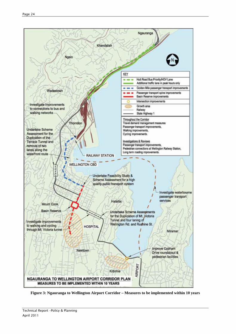
Overview diagrams are provided below which depict measures to be implemented within 10 years (Figure
3) and measures that may be implemented (beyond 10 years (Figure 4)). Table 1, also below, has been
extracted from the plan and provides further details about some of the most relevant measures.
Of particular importance to the Mt Victoria to Cobham Dr Study is the inclusion of the measure to:
Page 23
Technical Report –Policy & Planning
April 2011
undertake project feasibility studies and scheme assessment reports for both:
• Duplication of Mt Victoria Tunnel; and
• Four-laning Ruahine Street and Wellington Road within the next 10 years.
Measures of relevance to the study which were identified to be introduced within the next 10 years include
measures to:
• Implement passenger transport improvements (including bus priority measures, signal pre-emption, real time information) along the golden mile route to improve journey times, reliability and passenger
waiting and boarding provisions. Improvements to include the Golden Mile (from Lambton Interchange
to eastern end of Courtenay Place).
• Implement bus priority measures on arterial routes, including Kent/Cambridge Terrace, Taranaki
Street, and Adelaide Road.
• Implement bus priority measures to Wellington International Airport, Wellington Regional Hospital and key Suburban Centres, including:
� Newtown
� Hataitai
� Kilbirnie
� Brooklyn
� Island Bay
� Miramar
• Finalise and implement a Wellington City walking policy and a Wellington City cycling policy to make cycling safer and more convenient (these have since been released).
• Investigate water-borne passenger transport services between the Wellington CBD and Miramar
Peninsula, and improving passenger transport services to/from the airport.
• Design and construct improvements at the Basin Reserve to improve passenger transport, walking and cycling by separating north-south flows from east-west traffic.
• Investigate improvements to walking and cycling facilities in Mt Victoria Tunnel.
• Implement intersection improvements, including improved pedestrian facilities at Troy Street/Cobham Drive to reduce congestion and improve safety.
• Undertake a feasibility study for a high quality public transport system, including light rail (the most favourable option(s) will then be developed further by a more detailed scheme assessment after
2013/14).
• Review the operational performance and capacity of bus service provisions within the corridor following the completion of the Golden Mile bus lane improvements and the delivery of the new trolley buses.
This review should also assess the effectiveness of the Hataitai bus tunnel.
• Undertake a feasibility study for the four-laning of Ruahine Street and Wellington Road and for the duplication of the Mt Victoria Tunnel, considering in particular its relationship with the Basin Reserve
improvements and improved transport links from the airport to the CBD for freight, taxis and public
transport.
Many of these measures will be undertaken as feasibility studies initially and then scheme assessments
will follow for the preferred option(s).
Page 24
Technical Report –Policy & Planning
April 2011
Figure 3: Ngauranga to Wellington Airport Corridor – Measures to be implemented within 10 years
Page 25
Technical Report –Policy & Planning
April 2011
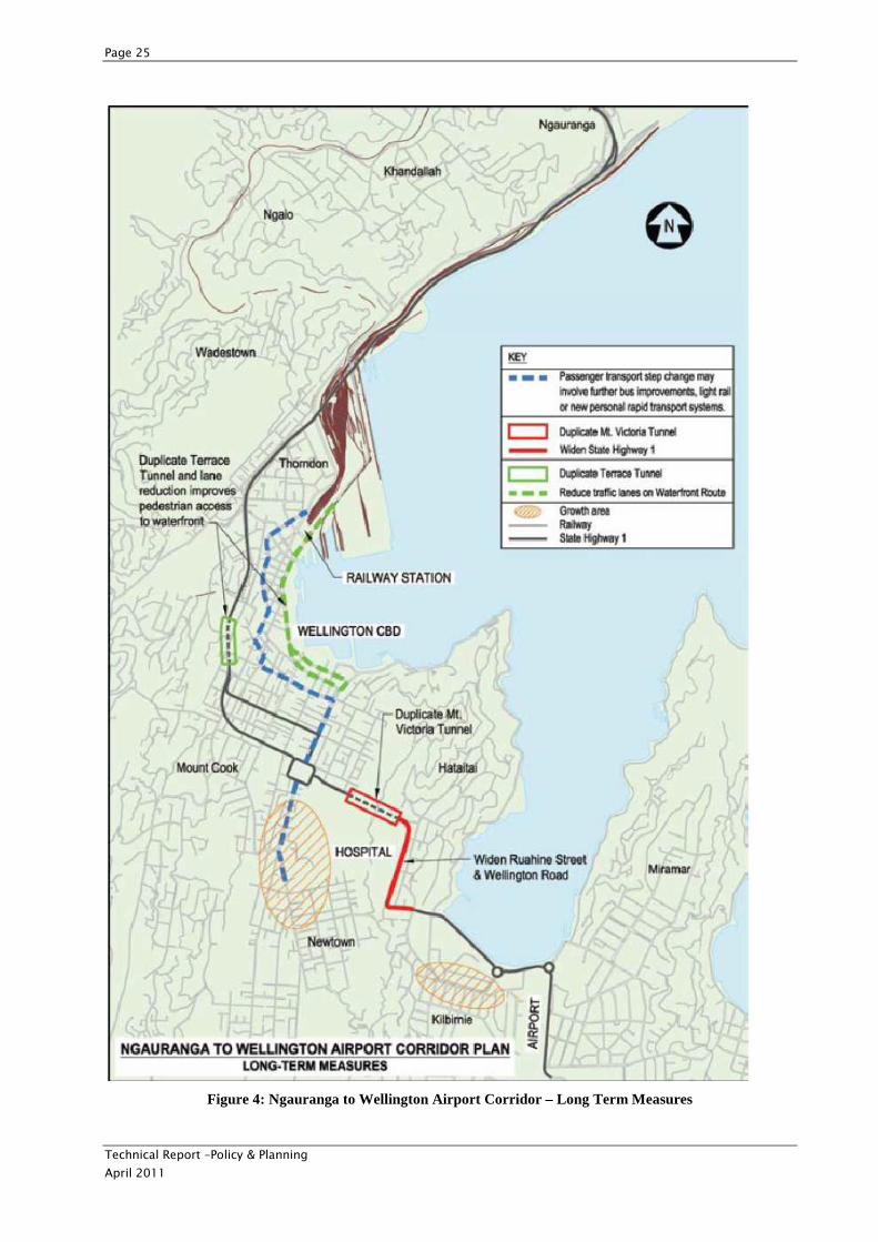
Figure 4: Ngauranga to Wellington Airport Corridor – Long Term Measures
Page 26
Technical Report –Policy & Planning
April 2011
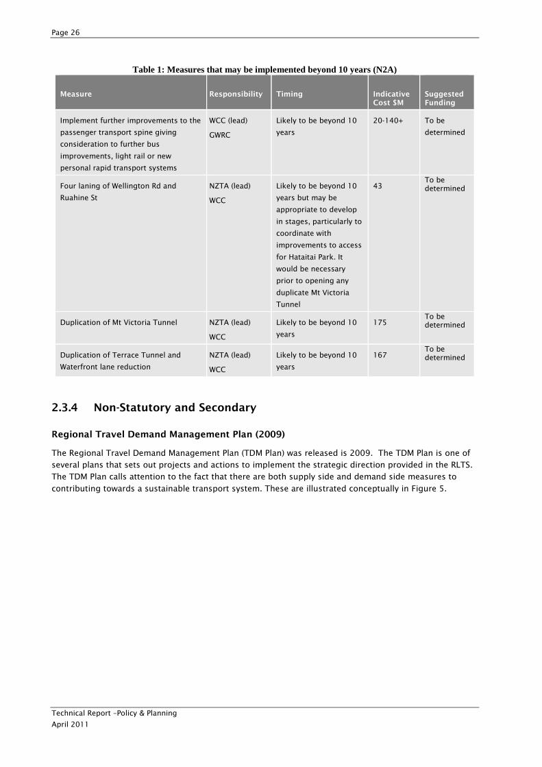
Table 1: Measures that may be implemented beyond 10 years (N2A)
Measure Responsibility Timing Indicative Cost $M
Suggested Funding
Implement further improvements to the
passenger transport spine giving
consideration to further bus
improvements, light rail or new
personal rapid transport systems
WCC (lead)
GWRC
Likely to be beyond 10
years
20-140+ To be
determined
Four laning of Wellington Rd and
Ruahine St
NZTA (lead)
WCC
Likely to be beyond 10
years but may be
appropriate to develop
in stages, particularly to
coordinate with
improvements to access
for Hataitai Park. It
would be necessary
prior to opening any
duplicate Mt Victoria
Tunnel
43 To be determined
Duplication of Mt Victoria Tunnel NZTA (lead)
WCC
Likely to be beyond 10
years
175 To be determined
Duplication of Terrace Tunnel and
Waterfront lane reduction
NZTA (lead)
WCC
Likely to be beyond 10
years
167 To be determined
2.3.4 Non-Statutory and Secondary
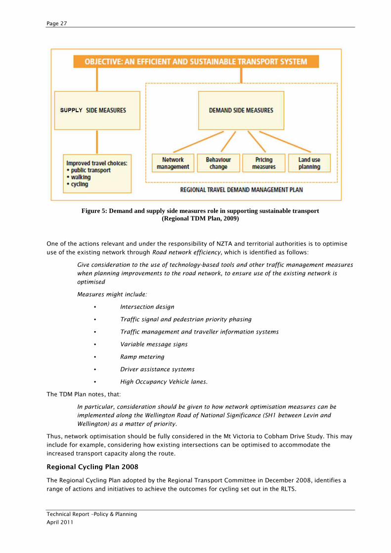
Regional Travel Demand Management Plan (2009)
The Regional Travel Demand Management Plan (TDM Plan) was released is 2009. The TDM Plan is one of
several plans that sets out projects and actions to implement the strategic direction provided in the RLTS.
The TDM Plan calls attention to the fact that there are both supply side and demand side measures to
contributing towards a sustainable transport system. These are illustrated conceptually in Figure 5.
Page 27
Technical Report –Policy & Planning
April 2011
Figure 5: Demand and supply side measures role in supporting sustainable transport (Regional TDM Plan, 2009)
One of the actions relevant and under the responsibility of NZTA and territorial authorities is to optimise
use of the existing network through Road network efficiency, which is identified as follows:
Give consideration to the use of technology-based tools and other traffic management measures
when planning improvements to the road network, to ensure use of the existing network is
optimised
Measures might include:
• Intersection design
• Traffic signal and pedestrian priority phasing
• Traffic management and traveller information systems
• Variable message signs
• Ramp metering
• Driver assistance systems
• High Occupancy Vehicle lanes.
The TDM Plan notes, that:
In particular, consideration should be given to how network optimisation measures can be
implemented along the Wellington Road of National Significance (SH1 between Levin and
Wellington) as a matter of priority.
Thus, network optimisation should be fully considered in the Mt Victoria to Cobham Drive Study. This may
include for example, considering how existing intersections can be optimised to accommodate the
increased transport capacity along the route.
Regional Cycling Plan 2008
The Regional Cycling Plan adopted by the Regional Transport Committee in December 2008, identifies a
range of actions and initiatives to achieve the outcomes for cycling set out in the RLTS.
Page 28
Technical Report –Policy & Planning
April 2011
The actions relevant to the study area include:
• Improve the cycling network.
• Improve cycling and public transport integration.
• Provide for cyclists in land development.
• Improve cycling connections between local
networks.
Regional Walking Plan
The Regional Walking Plan sets out an action plan with a series of high level initiatives aimed at
contributing to the outcomes of the RLTS. Actions identified in the plan which are relevant to the study
include: improve the pedestrian network and improve walking connections between local networks. In
addition, one of the actions identified as a responsibility of the territorial authorities is to review the
pedestrian network. Guidance for this review is given and includes the following pedestrian facility
considerations, which may be useful to guide the review and designing of walking facilities for the present
study:
• Footpath surfaces, alignment and obstructions.
• Crossing facilities and wait times.
• Personal safety/security and lighting.
• Aesthetics, shelter and street furniture.
• Route directness and connectivity.
• Signage and information.
• Needs of different types of pedestrians.
• Space allocation and traffic impacts.
• Road safety.
• Integration with other modes.
Technical Report – Policy & Planning
April 2011
2.4 Local/District Policy & Plans
2.4.1 Statutory and Primary
Wellington City Operative District Plan 2000
The Wellington City Council (WCC) sets out regulations associated with land use within the City in its
District Plan via the use of zoning (illustrated on planning maps) which are linked to specific zone rules.
The zoning under the Wellington City Council District Plan for the land covered by the proposed alignment
is as follows:
Paterson Street: Inner Residential
Ruahine Street: Outer Residential (eastern side)
Open Space C (western (Town Belt) side)
Taurima Street: Open Space B (triangle of land between Taurima Street and Ruahine Street)
Open Space C (northern and southern sides – western end)
Wellington Road: Outer Residential
Open Space B (small triangle of land on southern side of Ruahine St junction and land directly adjacent to
northern edge east of Evans Bay Parade)
Open Space A (Kilbirnie Park, located on southern side of Wellington Road between Kilbirnie Crescent and
Evans Bay Parade)
A full summary of District Plan matters relevant to the study is provided in 0; however some of the key
issues relevant to the study area include:
• Numerous heritage sites.
• Numerous heritage trees.
• Existing designations, such as for educational facilities and telecommunications.
• Some of the study area lies within a section of the Inner Residential zone which contains rules related to demolition that may prove restrictive.
• Other zones in the study area include Outer Residential, Open Space A, Open Space B, Open Space C,
Suburban Centres. The Open Space zones in particular have a number of controls which may restrict
development.
• Other planning chapters which are relevant to the development, including utilities, earthworks and
subdivision sections.
• Ground shaking hazard area.
• Existing bus tunnel is listed in District Plan.
• Te Ranga a Hiwi Precinct which lies above the existing Mt Victoria Tunnel and is a Maori heritage protection feature.
• Te Akatarewa Pa is identified as being above the tunnel alignment.
• Ridgeline/hilltop overlay.
• Numerous plan changes which are reviewed in 0.
Page 30
Technical Report –Policy & Planning
April 2011
2.4.2 Statutory and Secondary
There are no local statutory documents secondary to the project identified.
2.4.3 Non-Statutory and Primary
WCC Transport Strategy
The WCC Transport Strategy aims to ensure that Wellington’s transport system supports the city’s vision
for its future growth and function. The objective of the Strategy is to ensure the city’s transport system is
sustainable in the long term, meeting the economic, social, cultural and environmental aspirations of its
citizens. The Council adopted its current Transport Strategy in June 2006.
Future transport issues are identified in the WCC Transport Strategy as:
• Increasing congestion providing challenges to maintaining levels of service and travel time reliability on
arterial roads to and through the city
• Increased competition for road capacity from buses, cars, pedestrians and cyclists
• Providing better access to the port and airport.
The key ‘things to do’ identified in the transport strategy are:
• Develop the state highways and main arterial roads as the primary means of moving large volumes of traffic and freight to and through the city
• Develop public transport systems as the main means for the movement of people along the Urban Development Strategy growth spine
• Ensure continued access to the CBD for commuters
• Develop the port and airport as major contributors to the city and regional economy
• Develop measures to improve the energy efficiency of the city.
The long-term direction for transport from 2006 -2016 for Wellington is illustrated diagrammatically in
Figure 6.
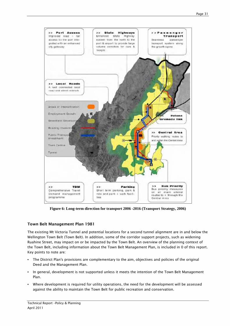
Page 31
Technical Report –Policy & Planning
April 2011
Figure 6: Long-term direction for transport 2006 -2016 (Transport Strategy, 2006)
Town Belt Management Plan 1981
The existing Mt Victoria Tunnel and potential locations for a second tunnel alignment are in and below the
Wellington Town Belt (Town Belt). In addition, some of the corridor support projects, such as widening
Ruahine Street, may impact on or be impacted by the Town Belt. An overview of the planning context of
the Town Belt, including information about the Town Belt Management Plan, is included in 0 of this report.
Key points to note are:
• The District Plan's provisions are complementary to the aim, objectives and policies of the original Deed and the Management Plan.
• In general, development is not supported unless it meets the intention of the Town Belt Management Plan.
• Where development is required for utility operations, the need for the development will be assessed
against the ability to maintain the Town Belt for public recreation and conservation.
Page 32
Technical Report –Policy & Planning
April 2011
• Numerous Aims and Objectives of the Town Belt Management Plan, including: “A Town Belt which is
managed in accordance with the principal intention of the original Deed of 1873, which is to keep the
Town Belt land forever ‘as a public recreation ground for the inhabitants of the City of Wellington’.”
Analysis of the proposed project against these objectives and a number of other supporting policies is
provided in 0.
Wellington City Council Walking Policy 2008
This Walking Policy was reviewed as part of this Study. The purpose of the Walking Policy is to provide a
framework for initiatives to collaboratively improve the pedestrian walking environment in Wellington.
With the primary focus of promoting walking trips that would otherwise be taken by car, the policy seeks
to improve the walking environment and increase the number of short trips made by people to work or
study, either as a single journey, or as part of a journey. The policy also seeks to increase walking activity
in suburban centres by encouraging people to walk to their local services and making walking to schools
more attractive for children.
The policy promotes connectivity with the open space access network. This is of relevance to the Project in
terms of improving pedestrian connectivity with the Town Belt, particularly across Ruahine Street. Also
important to fulfilling the purpose of the Walking Policy is continuing to provide pedestrian access
through the Mt Victoria Tunnel.
Wellington City Council Cycling Policy 2008
The Cycling Policy forms part of the overall transport planning for Wellington set out in the Transport
Strategy 2006. It provides more detail on cycling in Wellington and the context set by other policies and
strategies. It also creates a framework for the development of infrastructure and measures to improve the
safety and convenience of cycling and cycling facilities throughout the city.
In order to create an effective framework to provide a basis for action, the policy sets out objectives and
policies on how implementation should be approached. These include emphasising the importance of
quality and continuity of cycle routes, including provision of consistent signage and recognising cycling as
a means of commuting and as a form of recreation.
The policy also details proposals both in general terms for ongoing support (e.g. promoting the health
and recreational benefits of cycling) and as location-specific improvements to infrastructure. The focus of
the latter is to create a safer and more convenient network in areas where existing provision is disjointed
or does not allow access to key destinations. Providing better facilities for cyclists is also a key objective of
the policy.
The policy will have relevance to the Project in terms of continuing to provide cyclist access between the
CBD and Hataitai.
WCC Urban Development Strategy
The Urban Development Strategy (UDS) was published by WCC in 2006 and WCC is a signatory to the
Urban Design Protocol. The UDS sits alongside the WCC Transport Strategy and includes a growth concept
compatible with it (similar to Figure 6). The purpose of the UDS is “to ensure that future growth and
change reinforces the physical and spatial characteristics that make Wellington so distinctive, and
contribute to the stimulating and intense urban experience it offers.”
The UDS identifies growth factors (population growth, demographics etc.) for Wellington and risks to
managing growth, such as, “if it is not managed well, it [the growth] can destroy aspects of the city’s
sense of place that are valued highly.” The UDS perceives its challenge to be: “to ensure that future growth
and change reinforces the physical and spatial characteristics that make Wellington so distinctive; focuses
on high quality urban design and development; and contributes to the stimulating and intense urban
experience Wellington offers.”
The framework in which the UDS sits is illustrated below in Figure 7.
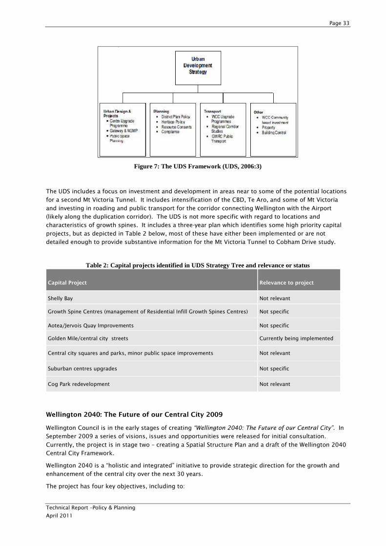
Page 33
Technical Report –Policy & Planning
April 2011
Figure 7: The UDS Framework (UDS, 2006:3)
The UDS includes a focus on investment and development in areas near to some of the potential locations
for a second Mt Victoria Tunnel. It includes intensification of the CBD, Te Aro, and some of Mt Victoria
and investing in roading and public transport for the corridor connecting Wellington with the Airport
(likely along the duplication corridor). The UDS is not more specific with regard to locations and
characteristics of growth spines. It includes a three-year plan which identifies some high priority capital
projects, but as depicted in Table 2 below, most of these have either been implemented or are not
detailed enough to provide substantive information for the Mt Victoria Tunnel to Cobham Drive study.
Table 2: Capital projects identified in UDS Strategy Tree and relevance or status
Capital Project Relevance to project
Shelly Bay Not relevant
Growth Spine Centres (management of Residential Infill Growth Spines Centres) Not specific
Aotea/Jervois Quay Improvements Not specific
Golden Mile/central city streets Currently being implemented
Central city squares and parks, minor public space improvements Not relevant
Suburban centres upgrades Not specific
Cog Park redevelopment Not relevant
Wellington 2040: The Future of our Central City 2009
Wellington Council is in the early stages of creating “Wellington 2040: The Future of our Central City”. In
September 2009 a series of visions, issues and opportunities were released for initial consultation.
Currently, the project is in stage two – creating a Spatial Structure Plan and a draft of the Wellington 2040
Central City Framework.
Wellington 2040 is a “holistic and integrated” initiative to provide strategic direction for the growth and
enhancement of the central city over the next 30 years.
The project has four key objectives, including to:
Page 34
Technical Report –Policy & Planning
April 2011
• Provide coordinated direction to the Council’s management of the central city
• Identify issues facing the central city in the short and longer term
• Identify an appropriate direction for the central city, including roles of its constituent parts
• Identify opportunities to add value, leverage investment, improve outcomes and generally add to the success of the central city.
Initial indications from the project
The consultation document and initial feedback received indicate a number of potential themes in the
project that may be relevant for the Mt Victoria to Cobham Drive Study. In particular:
• The project contains assumptions of significant residential growth in the city, and that the city centre is of key importance to the function and prosperity of the wider Wellington area.
Consultation showed strong emphasis from submitters on the importance of transport into the city. In
particular, there was interest in improving public transport and active modes, and minimising car access
to the city.
2.4.4 Non-Statutory and Secondary
The Urban Design Strategy 1994 (Non-statutory)
The Urban Design Strategy was prepared to assist WCC in achieving its vision for the future urban design
of the City. A review of this document is provided in the Environmental Technical Report.
The Adelaide Road Framework 2008
The Adelaide Road Framework outlines the vision for the future growth and development of the Adelaide
Road area. It expects significant urban changes over the next 10-20 years that will create a prosperous
and high-quality mixed-use area.
The vision provides for more residential development (to accommodate approximately 1,550 more people
by 2026), supported by public amenities and streetscape, employment opportunities, public transport,
and a transport route that works well for everyone. While the Adelaide Road Framework has some
relevance to the Mt Victoria to Cobham Drive Study as it is in the wider Ngauranga to Wellington Airport
Corridor, it is more relevant to the adjacent Basin Reserve Project.
More details about the Adelaide Road Framework, including changes to some of the planned actions, are
included in 0.
Kilbirnie Town Centre Draft Revitalisation Plan 2010
A Town Centre Plan has been developed for the Kilbirnie area as an urban design plan informed by traffic
planning and engineering. The study area examined is pictured in Figure 8 below. The Plan identifies
future growth projections for the area, issues in providing for growth and improving the overall quality of
life within the growth node together with opportunities to improve the centre.
The Plan identifies a number of key issues for the study area including:
• Transport to and from Kilbirnie is constrained by the Mt Victoria Tunnel
• Quality of street environment and urban environment in Kilbirnie is low, therefore making it hard to
attract new development
• Kilbirnie is predicted to grow by about 1000 people and 600 dwellings by 2031
• Most of the suburb is within a five minute walk to a bus stop and approximately 400 buses stop in
the town centre each week-day
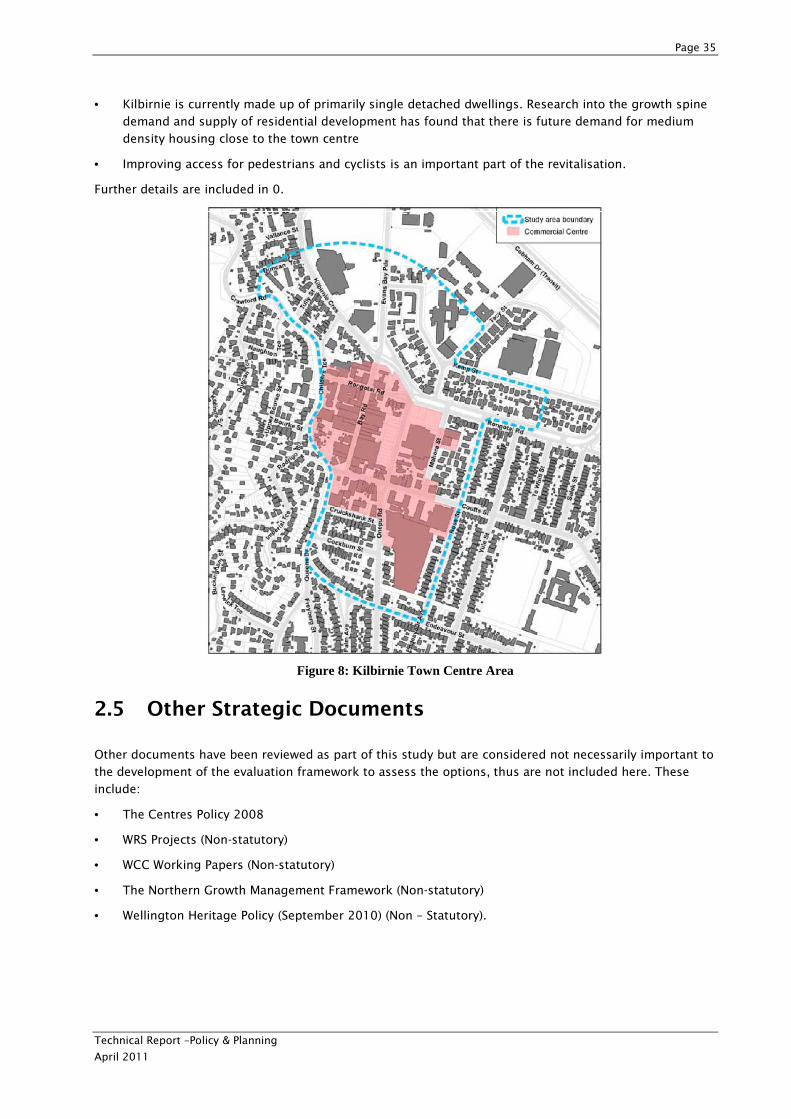
Page 35
Technical Report –Policy & Planning
April 2011
• Kilbirnie is currently made up of primarily single detached dwellings. Research into the growth spine
demand and supply of residential development has found that there is future demand for medium
density housing close to the town centre
• Improving access for pedestrians and cyclists is an important part of the revitalisation.
Further details are included in 0.
Figure 8: Kilbirnie Town Centre Area
2.5 Other Strategic Documents
Other documents have been reviewed as part of this study but are considered not necessarily important to
the development of the evaluation framework to assess the options, thus are not included here. These
include:
• The Centres Policy 2008
• WRS Projects (Non-statutory)
• WCC Working Papers (Non-statutory)
• The Northern Growth Management Framework (Non-statutory)
• Wellington Heritage Policy (September 2010) (Non – Statutory).
Page 36
Technical Report –Policy & Planning
April 2011
2.6 Relevant Documents - Other Projects
2.6.1 The Basin Reserve
The Basin Reserve project abuts the Mt Victoria to Cobham Drive Study area and is currently in the
investigation and design phase with the preparation of a Scoping Report and Scheme Assessment Report
being completed. Options include considering a location for a proposed grade separation to the north of
the Basin Reserve.
The purpose of the project is to contribute to providing a high-quality, high-capacity and reliable
passenger transport spine as part of the Wellington RoNS from Levin to Wellington International Airport
and to improve the reliability and travel times of the route for through traffic, particularly to Wellington
International Airport and Wellington Hospital. Another important consideration is to provide enhanced
amenities, safety and convenience for people who walk and cycle.
NZTA intends to consult with the public on the findings of the Basin Reserve investigations at the same
time as consultation is undertaken on the Mt Victoria to Cobham Drive Project. Reference should be made
to the SAMP for details of the approach to combining these two projects. The construction timing of the
Basin Reserve project also has the potential to impact on works associated with the Mt Victoria to Cobham
Drive Project.
2.6.2 Wellington Tunnels Refurbishment Project
The Terrace Tunnel and Mt Victoria Tunnel in Wellington are being upgraded to meet international fire and
life safety standards. While the exact nature of the refurbishments to the Terrace Tunnel are known and
have commenced, the schedule and nature of the Mt Victoria Tunnel refurbishments will be decided once
the preferred option for the Mt Victoria to Cobham Drive corridor is decided.
2.6.3 Wellington Airport Masterplan
The Wellington Airport Masterplan was approved by Wellington International Airport Ltd in January 2010.
The Masterplan outlines the proposed development of the Airport, with an outlook to 2030. Key aspects
of the draft Masterplan include:
• An intention to double passenger numbers through the airport to more than 10 million per year by
2030.
• The airport intends to invest $450 million in its infrastructure, some of which is already underway. Infrastructure investment includes terminal development, multi-level parking, and the creation of
reserves at either end of the runway for possible future lengthening (100m at the north end and 500m
at the south).
• There is a proposal to move Calabar Road east to allow for widening of the airport runway.
Implications for Mt Victoria to Cobham Drive Study are:
• Growth of the Airport could create significant extra traffic for the route to and from Wellington City and beyond.
• The Masterplan contains mention of regional access to the airport and localised areas of congestion along this route. It specifically notes support for the Ngauranga to Airport Corridor Plan.
• Future lengthening of the runway to the north could bring the runway over Cobham Drive, and moving
Calabar Rd to the east provides an opportunity to redesign the Cobham Drive/Calabar Rd roundabout.
Page 37
Technical Report –Policy & Planning
April 2011
• The Masterplan supports further development of the Airport Retail Park in Lyall Bay - this would be another source of traffic that could be connected to the duplication route.
2.6.4 Automated Traffic Management System (ATMS)
The Automated Traffic Management System (ATMS) project from the Terrace Tunnel to Petone is currently
underway. The project involves the installation of gantries, electronic signs, cabling and CCTV cameras to
assist with traffic management and traveller information with the intention of improving safety and traffic
flow along State Highways 1 and 2. This system is now largely operational. It is also proposed to extend
ATMS facilities through the Terrace Tunnel to Karo Dr as part of the Wellington tunnels refurbishment
projects.
2.6.5 Water Infrastructure Projects
According to the Wellington City Council Long Term Community Council Plan (LTCCP), major infrastructure
projects related to water supplies in the vicinity of the Mt Victoria to Cobham Drive Study area include:
• The water supply infrastructure along Taranaki Street (from the intersection with Buckle Street in the south to the harbour in the north) will undergo a significant upgrade.
• A second pump station will be installed in Kilbirnie near to the Cobham Drive/Wellington Road Intersection.
• A reservoir is being constructed in Newtown to provide additional supply capacity to the Wellington
CBD.
In addition, a water pump station is currently being installed at Tacy Street for the purpose of servicing the
proposed Wellington Indoor Community Sports Centre.
2.6.6 Badminton Club expansion
A resource consent application was made by the Wellington Badminton Association to expand the existing
Badminton Club buildings and undertake associated earthworks and modification, damage and removal of
indigenous vegetation within Open Space C Area. This development could have implications for the
widening of Ruahine Street proposed as part of the Mt Victoria to Cobham Drive Project. The NZTA’s
regional office made a neutral submission to the Council concerning the proposed activity. This activity
was deemed restricted discretionary under the District Plan and since has been declined by the WCC. The
decision has been appealed by the Wellington Badminton Association to the Environment Court, with NZTA
becoming an interested party under s.274 of the RMA. Currently WCC and the Wellington Badminton
Association are commencing informal mediation.
Page 38
Technical Report –Policy & Planning
April 2011
3 Key Policy & Planning Themes/Issues
3.1 Overview
As discussed, this review of policy and planning documents provides the context for the Mt Victoria to
Cobham Drive Study. This context has been important for the development of the evaluation framework
(refer to Scoping Report for details of the evaluation framework) for the high level Multi Criteria
Assessment Tool (MCAT) process to select options for more detailed assessment through the Scheme
Assessment Report (SAR) process. This context will also be relevant for the more detailed assessment of
preferred option(s), and for the preparation of statutory approvals documentation in accordance with the
requirements of the RMA ready for lodging with the EPA.
This section of the Technical Report – Policy & Planning provides an overview of some of the key planning
themes or issues that are relevant to the Project that should be considered in the overall evaluation of
options. This should be read in conjunction with the Evaluation of Options Report which includes a
description of each of the options and the evaluation framework which has been used to assess their
suitability.
3.2 Key National Policy & Planning Themes/Issues
The following are the key planning themes/issues for the project from a national perspective:
• Achieving an affordable, integrated, safe, responsive and sustainable land transport system.
• Assisting economic and regional development.
• Assisting safety and personal security.
• Improving access, mobility and reliability.
• Protecting and promoting public health.
• Ensuring environmental sustainability (managing adverse environmental effects) including the Town Belt.
• Recognition of New Zealand’s most essential routes – Roads of National Significance – in the GPS -
including the Wellington Northern Corridor – (Levin to Wellington).
• Promoting the identification, protection, preservation and observation of the historical and cultural heritage of New Zealand.
• Complying with the NES for Air Quality that requires that the combined discharge of pollutants in the Wellington CBD airsheds not exceed the standards set out.
• Ensuring NZTA Urban Design Policy is implemented in project.
3.3 Key Regional Policy & Planning Themes/Issues
There are some key regional policy and planning themes/issues that are generally applicable to all
alignment options. These include the following:
• The intention to duplicate the Mt Victoria Tunnel and widen Ruahine Street and Wellington Road is recognised in the Wellington Regional Land Transport Strategy 2010 – 2040 and the Ngauranga to
Wellington Airport Corridor (N2A) Plan 2008.
Page 39
Technical Report –Policy & Planning
April 2011
• The scope of the Mt Victoria to Cobham Drive Study is consistent with the Ngauranga to Airport Corridor Plan in terms of making improvements to the Mt Victoria to Cobham Drive corridor, but the
timeframe for undertaking the study has been brought forward.
• Maintaining or improving provision of a segregated public transport route that allows for a Rapid Transit Network is consistent with the Regional Public Transport Plan, WRS, Ngauranga to Wellington
Airport Corridor Plan, RLTS, and meeting the objectives of the NZTS as set out in the LTMA. Any
deterioration in public transport services would be inconsistent with these policies.
• Maintaining or improving the opportunity to access active modes is consistent with GWRC Cycling and Walking strategies as well as other policy documents. Likewise, longer (or less convenient due to
gradient) active modes will not be consistent with regional cycling and walking strategies.
• Any use of existing infrastructure rather than implementing new infrastructure will be aligned with the Regional TDM Plan.
• The need to ensure that the Regional Land Transport Programme is affordable for the regional community.
In addition, regional resource consents are likely to be required for the alignments under consideration. It
should be noted, however, that the number of regional consents will be different for different alignments:
• Soil disturbance for roading (Rule 1 of the Regional Soil Plan) and for soil disturbance of more than 1,000 cubic metres of soil on erosion prone land.
• Vegetation Disturbance - disturbance of vegetation on erosion prone land (Rules 3 & 4 of the Regional Soil Plan).
• Possible discharge to air consent for coating processes (Rule 15 of the Regional Air Quality
Management Plan), Abrasive blasting (Rule 16 of the Regional Air Quality Management Plan), cooling
towers/ventilation (Rule 17 of the Regional Air Quality Management Plan), miscellaneous discharge of
contaminants (Rule 22 of the Regional Air Quality Management Plan).
• Discharge of contaminants to land or water (Rule 1, Rule 2 of the Regional Plan for Discharges to Land), or discharge of stormwater (Rule 3 of the Regional Plan for Discharges to Land).
• Discharges to fresh water (Rule 5 of the Regional Freshwater Plan).
3.4 Key District Policy & Planning Themes/Issues
District Plan and Town Belt Management issues, such as heritage features or designations, are often
specific to certain locations and thus are specific to certain alignments. An overview of the planning issues
associated with each alignment is identified in 0. Many of the planning issues relate to District Plan
provisions and the Town Belt Management Plan. These are discussed more comprehensively in 0 and 0.
The following are the key planning themes/issues for the project from a local perspective:
• Maintaining or improving the opportunity to access active modes consistent with Wellington City Council’s Cycling and Walking strategies as well as other policy documents.
• Managing effects on the Town Belt and open spaces.
• Managing the effects on heritage features including heritage buildings (pre-1930 demolition) and archaeological sites.
• Town centre growth areas.
• Earthworks land use consents.
• Any improvements to accessing the town belt will be in line with Urban Design Protocol and WCC Urban Design Strategy and Town Belt Management Plan.
Page 40
Technical Report –Policy & Planning
April 2011
The statutory context for the study area has been described in detail in Section 2 of this report. The key
District Plan and Town Belt Management Plan issues (depending on the alignment chosen) include:
• Widening of Ruahine Street/Wellington Road may be wider than the existing 25m designation allows
for and may affect property access and the Badminton Hall
• Depending on the route chose, there may by encroachment to Town Belt Land - Town Belt acquisition
• Duplicate tunnel to the north; Inner Residential: Pre 1930's demolition Rule (relevant to the Paterson
St heritage properties); possible removal of, or effects on, a heritage building
• Heritage Building 18: Ettrick Cottage
• Wellington Road alignment may impact on a heritage tree
• Heritage Tree 86: Rata tree located at 176 Moxham Avenue
• Open Space B & Open Space C: Council, including town belt land
• Eastern Portal of the duplicate tunnel to the north impacts on Town Belt and requires the removal of
the Hataitai Kindy
• Effects on the Badminton Hall.
3.5 Conclusion
From a policy and planning perspective, there are no significant differences between the various
alignments proposed. In order to reflect the purpose of the LTMA, “to contribute to the aim of achieving
an affordable, integrated, safe, responsive, and sustainable land transport system” and regional and local
policy, the preferred option must ensure that modal and route choice opportunities (for public transport,
walking and cycling) are recognised and not constrained.
The following are the key matters to be taken into the SAR phase of the project:
• Addressing themes above through preparation of an Assessment of Environmental Effects (AEE) and consenting document.
• Scoping of regional resource consents.
• Further consultation on final preferred option.
• Preparation of statutory approvals documentation, AEE and Land Requirement Plan.
• Assessment of proposal against s.171 of the RMA.
• Ensuring robustness of documentation to support the application to the EPA.
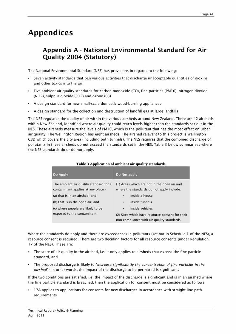
Page 41
Technical Report –Policy & Planning
April 2011
Appendices
Appendix A - National Environmental Standard for Air Quality 2004 (Statutory)
The National Environmental Standard (NES) has provisions in regards to the following:
• Seven activity standards that ban various activities that discharge unacceptable quantities of dioxins and other toxics into the air
• Five ambient air quality standards for carbon monoxide (CO), fine particles (PM10), nitrogen dioxide (NO2), sulphur dioxide (SO2) and ozone (03)
• A design standard for new small-scale domestic wood-burning appliances
• A design standard for the collection and destruction of landfill gas at large landfills
The NES regulates the quality of air within the various airsheds around New Zealand. There are 42 airsheds
within New Zealand, identified where air quality could reach levels higher than the standards set out in the
NES. These airsheds measure the levels of PM10, which is the pollutant that has the most effect on urban
air quality. The Wellington Region has eight airsheds. The airshed relevant to this project is Wellington
CBD which covers the city area (including both tunnels). The NES requires that the combined discharge of
pollutants in these airsheds do not exceed the standards set in the NES. Table 3 below summarises where
the NES standards do or do not apply.
Table 3 Application of ambient air quality standards
Do Apply Do Not apply
The ambient air quality standard for a
contaminant applies at any place -
(a) that is in an airshed; and
(b) that is in the open air; and
(c) where people are likely to be
exposed to the contaminant.
(1) Areas which are not in the open air and
where the standards do not apply include:
• inside a house
• inside tunnels
• inside vehicles
(2) Sites which have resource consent for their
non-compliance with air quality standards.
Where the standards do apply and there are exceedances in pollutants (set out in Schedule 1 of the NES), a
resource consent is required. There are two deciding factors for all resource consents (under Regulation
17 of the NES). These are:
• The state of air quality in the airshed, i.e. it only applies to airsheds that exceed the fine particle
standard, and
• The proposed discharge is likely to "increase significantly the concentration of fine particles in the
airshed" - in other words, the impact of the discharge to be permitted is significant.
If the two conditions are satisfied, i.e. the impact of the discharge is significant and is in an airshed where
the fine particle standard is breached, then the application for consent must be considered as follows:
• 17A applies to applications for consents for new discharges in accordance with straight line path
requirements
Page 42
Technical Report –Policy & Planning
April 2011
• 17B applies to applications for consents for new discharges in accordance with curved line path requirements
• 17C applies to applications for consents for existing discharges (i.e. renewals) and applications
incorporating offsets.
Further, there are specific provisions in relation to assessing resource consent for the various pollutants
themselves (including discharges of PM10, carbon monoxide, oxides of nitrogen, volatile organic
compounds, and sulphur dioxide).
The NES standards override the regional plan provisions in all circumstances and it is mandatory for
regional councils to modify any provisions in the existing regional plans that are contrary to the NES
standards. Where modification has not yet been included in the regional plan (such as in the case for the
Regional Air Quality Management Plan for the Wellington Region), an assessment under the NES remains
relevant and any activities infringing on the NES standards would need to apply for a resource consent
from the regional council under the NES.
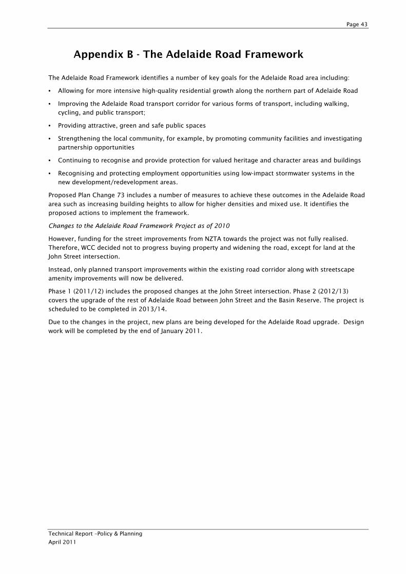
Page 43
Technical Report –Policy & Planning
April 2011
Appendix B - The Adelaide Road Framework
The Adelaide Road Framework identifies a number of key goals for the Adelaide Road area including:
• Allowing for more intensive high-quality residential growth along the northern part of Adelaide Road
• Improving the Adelaide Road transport corridor for various forms of transport, including walking, cycling, and public transport;
• Providing attractive, green and safe public spaces
• Strengthening the local community, for example, by promoting community facilities and investigating partnership opportunities
• Continuing to recognise and provide protection for valued heritage and character areas and buildings
• Recognising and protecting employment opportunities using low-impact stormwater systems in the new development/redevelopment areas.
Proposed Plan Change 73 includes a number of measures to achieve these outcomes in the Adelaide Road
area such as increasing building heights to allow for higher densities and mixed use. It identifies the
proposed actions to implement the framework.
Changes to the Adelaide Road Framework Project as of 2010
However, funding for the street improvements from NZTA towards the project was not fully realised.
Therefore, WCC decided not to progress buying property and widening the road, except for land at the
John Street intersection.
Instead, only planned transport improvements within the existing road corridor along with streetscape
amenity improvements will now be delivered.
Phase 1 (2011/12) includes the proposed changes at the John Street intersection. Phase 2 (2012/13)
covers the upgrade of the rest of Adelaide Road between John Street and the Basin Reserve. The project is
scheduled to be completed in 2013/14.
Due to the changes in the project, new plans are being developed for the Adelaide Road upgrade. Design
work will be completed by the end of January 2011.
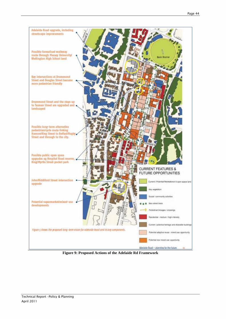
Page 44
Technical Report –Policy & Planning
April 2011
Figure 9: Proposed Actions of the Adelaide Rd Framework
Page 45
Technical Report –Policy & Planning
April 2011
Appendix C- Kilbirnie Town Centre Draft Revitalisation Plan 2010 (Non-statutory)
A Town Centre Plan (the Plan) has been developed for the Kilbirnie area and is an urban design plan
informed by traffic planning and engineering. The Plan identifies future growth projections for the area,
issues in providing for growth, and improving the overall quality of life within the growth node, and
opportunities to improve the centre.
The Plan identifies a number of key issues for the study area including:
• Transport to and from Kilbirnie is constrained by the Mt Victoria Tunnel
• Quality of street environment and urban environment in Kilbirnie is low, therefore making it hard to
attract new development
• Kilbirnie is predicted to grow by about 1000 people and 600 dwellings by 2031
• Most of the suburb is within a five minute walk to a bus stop and approximately 400 buses stop in the
town centre each week-day
• Kilbirnie is currently made up of primarily single detached dwellings. Research into the growth spine demand and supply of residential development has found that there is future demand for medium
density housing close to the town centre
• Improving access for pedestrians and cyclists is an important part of the revitalisation.
Key goals identified to guide future development in the town centre are:
• Develop and enhance Bay Road as the main street
• Provide for and encourage a wider range of non-retail activities in the town centre
• Support existing and new retail anchor tenants
• Improve sense of place
• Improve public spaces
• Manage traffic and parking
• Maximise the potential of public transport systems
• Improve pedestrian and cycle access
• Encourage more people to live in and around the town centre
• Improve housing choice
• Maximise the potential of community infrastructure
• Improve resilience of water-based infrastructure.
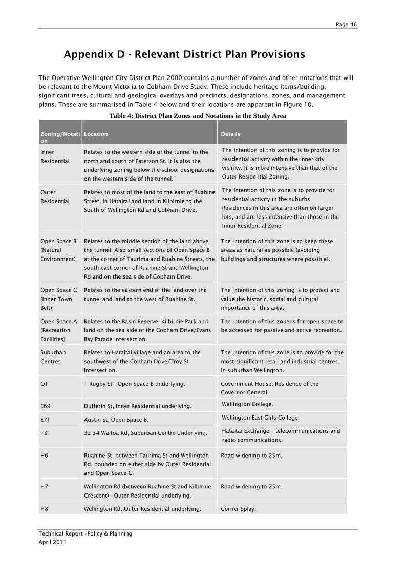
Page 46
Technical Report –Policy & Planning
April 2011
Appendix D - Relevant District Plan Provisions
The Operative Wellington City District Plan 2000 contains a number of zones and other notations that will
be relevant to the Mount Victoria to Cobham Drive Study. These include heritage items/building,
significant trees, cultural and geological overlays and precincts, designations, zones, and management
plans. These are summarised in Table 4 below and their locations are apparent in Figure 10.
Table 4: District Plan Zones and Notations in the Study Area
Zoning/Notation
Location Details
Inner
Residential
Relates to the western side of the tunnel to the
north and south of Paterson St. It is also the
underlying zoning below the school designations
on the western side of the tunnel.
The intention of this zoning is to provide for
residential activity within the inner city
vicinity. It is more intensive than that of the
Outer Residential Zoning.
Outer
Residential
Relates to most of the land to the east of Ruahine
Street, in Hataitai and land in Kilbirnie to the
South of Wellington Rd and Cobham Drive.
The intention of this zone is to provide for
residential activity in the suburbs.
Residences in this area are often on larger
lots, and are less intensive than those in the
Inner Residential Zone.
Open Space B
(Natural
Environment)
Relates to the middle section of the land above
the tunnel. Also small sections of Open Space B
at the corner of Taurima and Ruahine Streets, the
south-east corner of Ruahine St and Wellington
Rd and on the sea side of Cobham Drive.
The intention of this zone is to keep these
areas as natural as possible (avoiding
buildings and structures where possible).
Open Space C
(Inner Town
Belt)
Relates to the eastern end of the land over the
tunnel and land to the west of Ruahine St.
The intention of this zoning is to protect and
value the historic, social and cultural
importance of this area.
Open Space A
(Recreation
Facilities)
Relates to the Basin Reserve, Kilbirnie Park and
land on the sea side of the Cobham Drive/Evans
Bay Parade Intersection.
The intention of this zone is for open space to
be accessed for passive and active recreation.
Suburban
Centres
Relates to Hataitai village and an area to the
southwest of the Cobham Drive/Troy St
intersection.
The intention of this zone is to provide for the
most significant retail and industrial centres
in suburban Wellington.
Q1 1 Rugby St - Open Space B underlying. Government House, Residence of the
Governor General
E69 Dufferin St, Inner Residential underlying. Wellington College.
E71 Austin St, Open Space B. Wellington East Girls College.
T3 32-34 Waitoa Rd, Suburban Centre Underlying. Hataitai Exchange – telecommunications and
radio communications.
H6 Ruahine St, between Taurima St and Wellington
Rd, bounded on either side by Outer Residential
and Open Space C.
Road widening to 25m.
H7 Wellington Rd (between Ruahine St and Kilbirnie
Crescent). Outer Residential underlying.
Road widening to 25m.
H8 Wellington Rd. Outer Residential underlying. Corner Splay.
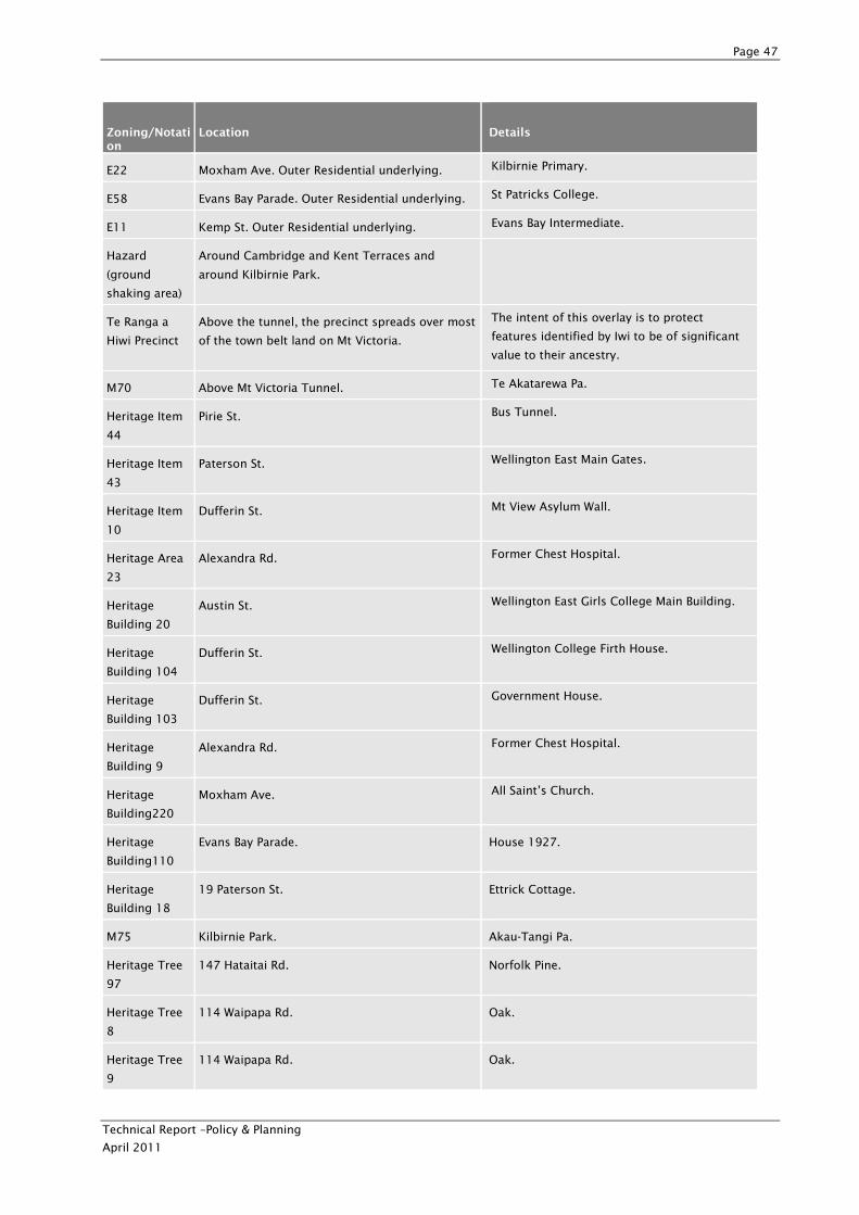
Page 47
Technical Report –Policy & Planning
April 2011
Zoning/Notation
Location Details
E22 Moxham Ave. Outer Residential underlying. Kilbirnie Primary.
E58 Evans Bay Parade. Outer Residential underlying. St Patricks College.
E11 Kemp St. Outer Residential underlying. Evans Bay Intermediate.
Hazard
(ground
shaking area)
Around Cambridge and Kent Terraces and
around Kilbirnie Park.
Te Ranga a
Hiwi Precinct
Above the tunnel, the precinct spreads over most
of the town belt land on Mt Victoria.
The intent of this overlay is to protect
features identified by Iwi to be of significant
value to their ancestry.
M70 Above Mt Victoria Tunnel. Te Akatarewa Pa.
Heritage Item
44
Pirie St. Bus Tunnel.
Heritage Item
43
Paterson St. Wellington East Main Gates.
Heritage Item
10
Dufferin St. Mt View Asylum Wall.
Heritage Area
23
Alexandra Rd. Former Chest Hospital.
Heritage
Building 20
Austin St. Wellington East Girls College Main Building.
Heritage
Building 104
Dufferin St. Wellington College Firth House.
Heritage
Building 103
Dufferin St. Government House.
Heritage
Building 9
Alexandra Rd. Former Chest Hospital.
Heritage
Building220
Moxham Ave. All Saint’s Church.
Heritage
Building110
Evans Bay Parade. House 1927.
Heritage
Building 18
19 Paterson St. Ettrick Cottage.
M75 Kilbirnie Park. Akau-Tangi Pa.
Heritage Tree
97
147 Hataitai Rd. Norfolk Pine.
Heritage Tree
8
114 Waipapa Rd. Oak.
Heritage Tree
9
114 Waipapa Rd. Oak.
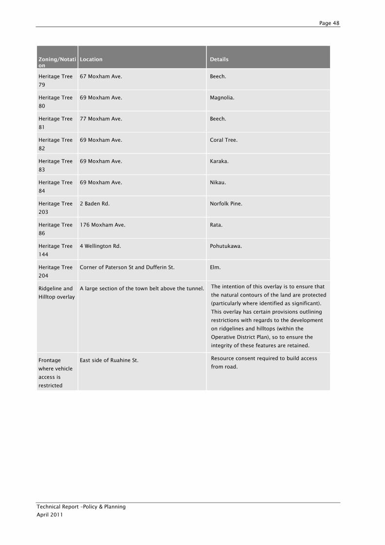
Page 48
Technical Report –Policy & Planning
April 2011
Zoning/Notation
Location Details
Heritage Tree
79
67 Moxham Ave. Beech.
Heritage Tree
80
69 Moxham Ave. Magnolia.
Heritage Tree
81
77 Moxham Ave. Beech.
Heritage Tree
82
69 Moxham Ave. Coral Tree.
Heritage Tree
83
69 Moxham Ave. Karaka.
Heritage Tree
84
69 Moxham Ave. Nikau.
Heritage Tree
203
2 Baden Rd. Norfolk Pine.
Heritage Tree
86
176 Moxham Ave. Rata.
Heritage Tree
144
4 Wellington Rd. Pohutukawa.
Heritage Tree
204
Corner of Paterson St and Dufferin St. Elm.
Ridgeline and
Hilltop overlay
A large section of the town belt above the tunnel. The intention of this overlay is to ensure that
the natural contours of the land are protected
(particularly where identified as significant).
This overlay has certain provisions outlining
restrictions with regards to the development
on ridgelines and hilltops (within the
Operative District Plan), so to ensure the
integrity of these features are retained.
Frontage
where vehicle
access is
restricted
East side of Ruahine St. Resource consent required to build access
from road.
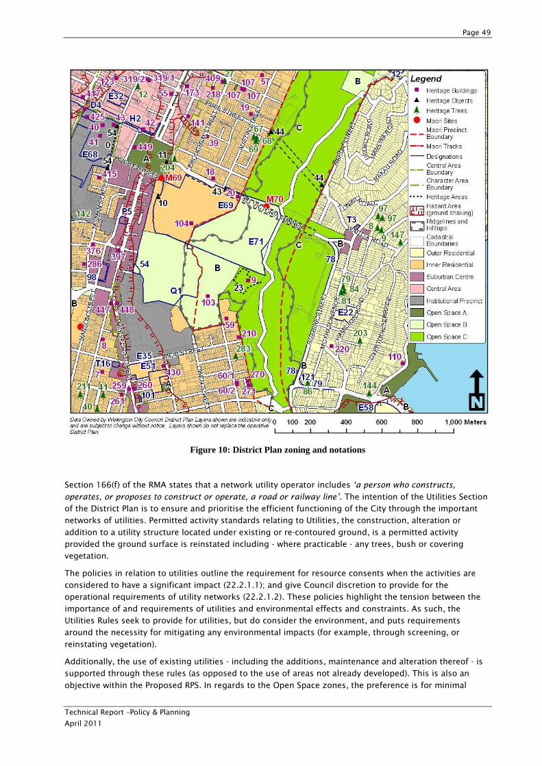
Page 49
Technical Report –Policy & Planning
April 2011
Figure 10: District Plan zoning and notations
Section 166(f) of the RMA states that a network utility operator includes ‘a person who constructs,
operates, or proposes to construct or operate, a road or railway line’. The intention of the Utilities Section
of the District Plan is to ensure and prioritise the efficient functioning of the City through the important
networks of utilities. Permitted activity standards relating to Utilities, the construction, alteration or
addition to a utility structure located under existing or re-contoured ground, is a permitted activity
provided the ground surface is reinstated including - where practicable - any trees, bush or covering
vegetation.
The policies in relation to utilities outline the requirement for resource consents when the activities are
considered to have a significant impact (22.2.1.1); and give Council discretion to provide for the
operational requirements of utility networks (22.2.1.2). These policies highlight the tension between the
importance of and requirements of utilities and environmental effects and constraints. As such, the
Utilities Rules seek to provide for utilities, but do consider the environment, and puts requirements
around the necessity for mitigating any environmental impacts (for example, through screening, or
reinstating vegetation).
Additionally, the use of existing utilities - including the additions, maintenance and alteration thereof - is
supported through these rules (as opposed to the use of areas not already developed). This is also an
objective within the Proposed RPS. In regards to the Open Space zones, the preference is for minimal
Page 50
Technical Report –Policy & Planning
April 2011
development. Utilities are, however, provided for with controls that relate to size, earthworks, and design
(as not a permitted activity).
General rules also apply and relate to processes such as earthworks and subdivision.
Open Space C (Wellington City District Plan)
The Study Area includes an area of Open Space C. Some of the key relevant issues pertaining to
development on Open Space C land include:
• Activities and uses on publicly owned land are required to obtain permission (such as a lease or a license) from the Council as the administering authority. NZTA are investigating mechanisms to gain
access/purchase Open Space C land if required.
• All activities will also have regard to any relevant management plans and legislation (for example the Wellington Town Belt Management Plan, the Town Belt Deed and also the Reserves Act 1977).
• The Town Belt is administered under the terms of its own Deed and the Wellington Town Belt Management Plan (under the Reserves Act).
• Open Space is characterised by the fact that it has few buildings. The enjoyment of open space from an
amenity/visual perspective needs to be taken into account when activities in open space areas are
being considered.
• The Inner Town Belt is valued for its historic, social and cultural importance. The Wellington City
Council acts as trustee of the Inner Town Belt for and on behalf of the people of Wellington. The Inner
Town Belt is zoned as Open Space C and identified on the Planning Maps. In addition to the District
Plan requirements, the Inner Town Belt is administered under the terms of its own deed and also the
Wellington Town Belt Management Plan.
Relevant objectives and policies of Open Space C land are identified and commented on with regards to
the Project in Table 5.
Table 5: Open Space C relevant Objectives and Policies
Reference Provision Comment / analysis
Objective
16.5.1
To maintain, protect and enhance the open spaces of
Wellington City.
Structures have been proposed to
be underground where possible.
Policy
16.5.1.3
Manage the impacts of activities in the Inner Town Belt in
order to protect and preserve its special qualities for the
benefit of future generations.
Any adverse environmental effects
will be considered through the AEE
prepared as part of the consenting
documentation, and mitigation of
effects will be offered.
Policy
16.5.1.4
Recognise the special status of Wellington’s Inner Town Belt
and manage the impacts of activities in order to protect and
manage its special qualities for the benefit of future
generations.
Relevant evaluation criteria have
been included in the evaluation
framework.
Objective
16.5.2
To maintain and enhance natural features (including
landscapes and ecosystems) that contributes to Wellington’s
natural environment.
Consideration of maintaining and
enhancing natural features would
need to be considered in any
detail design of the preferred
route.
Policy Restrict the construction of [buildings] structures and Relevant evaluation criteria have
Page 51
Technical Report –Policy & Planning
April 2011
Reference Provision Comment / analysis
16.5.2.2 earthworks on [identified ridgelines and hilltops.] been included in the evaluation
framework.
Policy
16.5.2.3
Encourage retention of existing native vegetation and where
appropriate re-introduce native cover.
Potential for native cover plantings
if existing native vegetation is
removed.
Plan Changes to the Wellington City Operative District Plan
A number of proposed plan changes are relevant to the Mt Victoria Tunnel to Cobham Drive Study area.
These plan changes are relevant to District Plan zoning and notation in the area. Proposed plan changes
are summarised in Table 6.
Table 6: Summary of Relevant Proposed Plan Changes
Zoning/Notation Location Details
Area of Change An area of Kilbirnie around Kilbirnie
Park
Introduced by PC 72, allows greater levels of
development
Outer Residential 2 Area Evans Bay Parade
Hataitai Centre Hataitai Small extension to the Hataitai Suburban
Centre introduced in PC 73
Inner Residential Area Mt Victoria side of the Tunnel
Hataitai Centre Heritage
Area
Hataitai Village PC 75 makes Hataitai Village a centres area
Coastal Area design
guide
Evans Bay
Operative Plan Change 33 - Ridgelines and Hilltops (Visual Amenity)
Operative Plan Change 33 – Ridgelines and Hilltops (Visual Amenity) and Rural Area was made operative in
November 2009. This Plan Change has now been incorporated into the District Plan.
The intent of this Plan Change is to regulate and control the effects of any structures and activities
allowable upon areas zoned as Open Space B or C. This Plan Change identified the importance of
protecting the hilltops and ridgelines. It takes into account the natural contours of the land and
emphasises the protection of these vistas. Assessment criteria to achieve this include:
• Visual effects – whether considered to be unobtrusive (consideration including visibility of structures,
minimising skyline effects and ensuring visual continuity on the upper slopes of the ridgeline or
hilltop)
• Whether Open Space character is maintained
• Whether the proposal reflects the relevant provisions of Reserves Act 1977, Queen Elizabeth II National Trust Act 1977, other management plans applicable including the Town Belt Management Plan and the
Town Belt Deed 1873
• Public access
Page 52
Technical Report –Policy & Planning
April 2011
• If within Maori Precinct, consultation is undertaken; and
• Effect of access ways
• Any removal, relocation or deposit of earth (not a Permitted Activity) is then a Discretionary
(Unrestricted) Activity. The identified assessment criterion for this includes the following
considerations:
• Extent of which any earth is cut that will remove existing vegetation or alter landforms or affect
water quality
• Extent to which any earthworks may impact on prominent or visually sensitive environments
• The necessity of carrying out the works.
Proposed Plan Change 43 - Heritage
Proposed District Plan Change 43 (DPC 43) which relates to heritage was publicly notified on 1 May 2006
and made operative in 2007. It introduced a revised set of heritage provisions, except for the rules
relating to listed trees and Maori sites. The purpose of the change was to ensure that the District Plan
deals with heritage issues more effectively. The key provisions of the proposed Plan Change are:
• Redrafted objectives and policies to emphasise the protection of historic heritage in accordance with
section 6(f) of the Resource Management Act 1991 and the direction of the Council’s Built Heritage
Policy.
• Removal of Controlled Activity provisions, and additions and alterations to listed heritage buildings
made a Discretionary Activity (Restricted or Unrestricted, depending on the extent of the modifications
to the building).
• Demolition or relocation of listed buildings or objects made a Discretionary Activity (Unrestricted).
• New rules controlling the development of non-listed buildings and/or subdivision on the site of a listed heritage building or object to protect the setting of the listed item.
• Enhanced heritage area provisions including control of the demolition or relocation of identified
contributing buildings or structures within a heritage area, subdivision and earthworks.
• New Chapter 3 provisions outlining the information to be supplied with resource consent applications for work affecting listed heritage items.
Plan Change 70 - Earthworks
Plan Change 70, which relates to Earthworks, is now operative. This Plan Change introduces new
provisions for earthworks with the intent of managing this activity separately (introducing new District
Plan Chapters 29 and 30 specifically related to earthworks within the various zones of the City). In
addition, the Plan Change also identifies specific provisions for the various zoning chapters (such as
Residential and Open Space zonings). As a general rule, within the Residential, Open Space A and C zones,
earthworks of no more than 250m² are permitted. In the more sensitive zones, such as Open Space B,
areas with the Ridgelines and Hilltops overlay and sites containing Heritage Items, the general permitted
area of earthworks is 100m².
The Plan Change has implications for the Project as it requires compliance from utility operators as well.
Utility operators were previously exempt from earthworks rules in the zone provisions, thus the
earthworks associated with tunnelling will be significantly impacted by this Plan Change.
Proposed Plan Change 73 – Suburban Centres
Proposed Plan Change 73 which relates to Suburban Centres, was publically notified on 28 September
2010, and is now going through an appeals process.
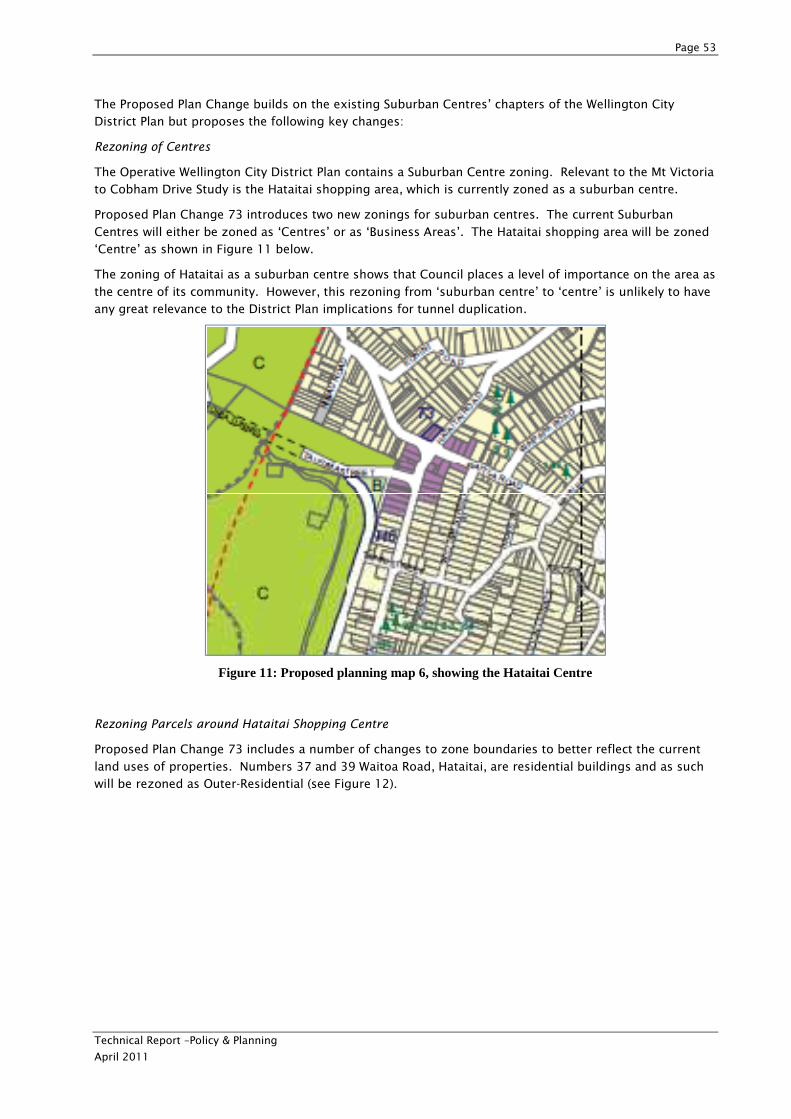
Page 53
Technical Report –Policy & Planning
April 2011
The Proposed Plan Change builds on the existing Suburban Centres’ chapters of the Wellington City
District Plan but proposes the following key changes:
Rezoning of Centres
The Operative Wellington City District Plan contains a Suburban Centre zoning. Relevant to the Mt Victoria
to Cobham Drive Study is the Hataitai shopping area, which is currently zoned as a suburban centre.
Proposed Plan Change 73 introduces two new zonings for suburban centres. The current Suburban
Centres will either be zoned as ‘Centres’ or as ‘Business Areas’. The Hataitai shopping area will be zoned
‘Centre’ as shown in Figure 11 below.
The zoning of Hataitai as a suburban centre shows that Council places a level of importance on the area as
the centre of its community. However, this rezoning from ‘suburban centre’ to ‘centre’ is unlikely to have
any great relevance to the District Plan implications for tunnel duplication.
Figure 11: Proposed planning map 6, showing the Hataitai Centre
Rezoning Parcels around Hataitai Shopping Centre
Proposed Plan Change 73 includes a number of changes to zone boundaries to better reflect the current
land uses of properties. Numbers 37 and 39 Waitoa Road, Hataitai, are residential buildings and as such
will be rezoned as Outer-Residential (see Figure 12).
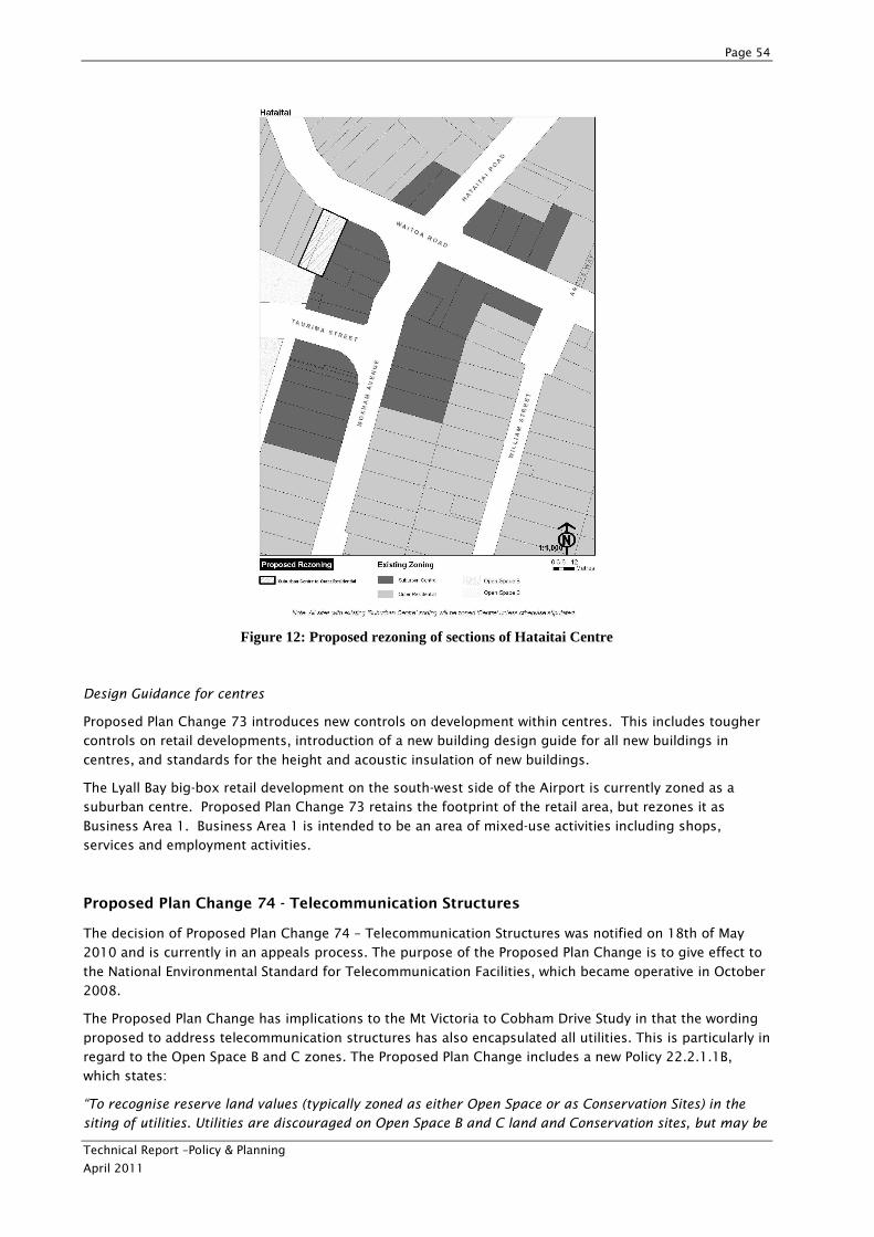
Page 54
Technical Report –Policy & Planning
April 2011
Figure 12: Proposed rezoning of sections of Hataitai Centre
Design Guidance for centres
Proposed Plan Change 73 introduces new controls on development within centres. This includes tougher
controls on retail developments, introduction of a new building design guide for all new buildings in
centres, and standards for the height and acoustic insulation of new buildings.
The Lyall Bay big-box retail development on the south-west side of the Airport is currently zoned as a
suburban centre. Proposed Plan Change 73 retains the footprint of the retail area, but rezones it as
Business Area 1. Business Area 1 is intended to be an area of mixed-use activities including shops,
services and employment activities.
Proposed Plan Change 74 - Telecommunication Structures
The decision of Proposed Plan Change 74 – Telecommunication Structures was notified on 18th of May
2010 and is currently in an appeals process. The purpose of the Proposed Plan Change is to give effect to
the National Environmental Standard for Telecommunication Facilities, which became operative in October
2008.
The Proposed Plan Change has implications to the Mt Victoria to Cobham Drive Study in that the wording
proposed to address telecommunication structures has also encapsulated all utilities. This is particularly in
regard to the Open Space B and C zones. The Proposed Plan Change includes a new Policy 22.2.1.1B,
which states:
“To recognise reserve land values (typically zoned as either Open Space or as Conservation Sites) in the
siting of utilities. Utilities are discouraged on Open Space B and C land and Conservation sites, but may be
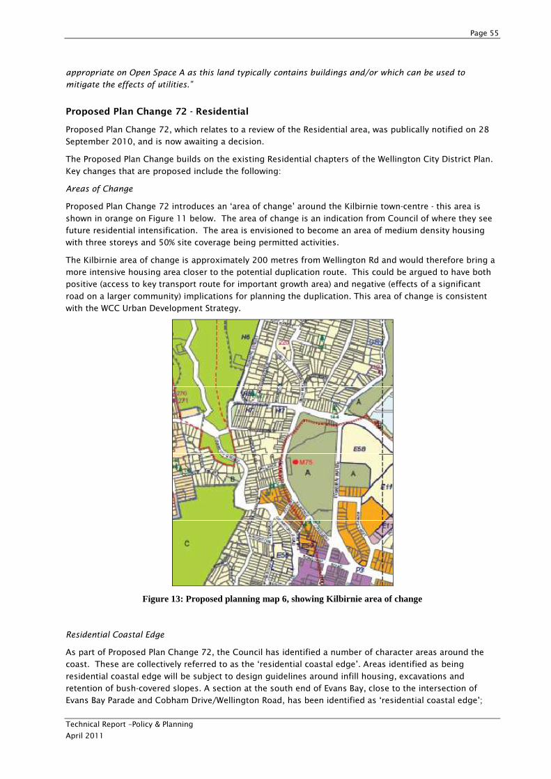
Page 55
Technical Report –Policy & Planning
April 2011
appropriate on Open Space A as this land typically contains buildings and/or which can be used to
mitigate the effects of utilities.”
Proposed Plan Change 72 - Residential
Proposed Plan Change 72, which relates to a review of the Residential area, was publically notified on 28
September 2010, and is now awaiting a decision.
The Proposed Plan Change builds on the existing Residential chapters of the Wellington City District Plan.
Key changes that are proposed include the following:
Areas of Change
Proposed Plan Change 72 introduces an ‘area of change’ around the Kilbirnie town-centre - this area is
shown in orange on Figure 11 below. The area of change is an indication from Council of where they see
future residential intensification. The area is envisioned to become an area of medium density housing
with three storeys and 50% site coverage being permitted activities.
The Kilbirnie area of change is approximately 200 metres from Wellington Rd and would therefore bring a
more intensive housing area closer to the potential duplication route. This could be argued to have both
positive (access to key transport route for important growth area) and negative (effects of a significant
road on a larger community) implications for planning the duplication. This area of change is consistent
with the WCC Urban Development Strategy.
Figure 13: Proposed planning map 6, showing Kilbirnie area of change
Residential Coastal Edge
As part of Proposed Plan Change 72, the Council has identified a number of character areas around the
coast. These are collectively referred to as the ‘residential coastal edge’. Areas identified as being
residential coastal edge will be subject to design guidelines around infill housing, excavations and
retention of bush-covered slopes. A section at the south end of Evans Bay, close to the intersection of
Evans Bay Parade and Cobham Drive/Wellington Road, has been identified as ‘residential coastal edge’;
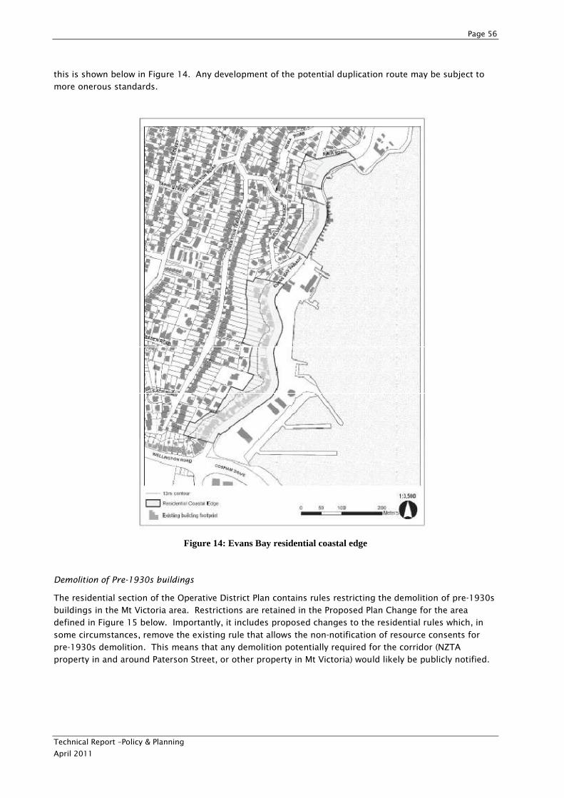
Page 56
Technical Report –Policy & Planning
April 2011
this is shown below in Figure 14. Any development of the potential duplication route may be subject to
more onerous standards.
Figure 14: Evans Bay residential coastal edge
Demolition of Pre-1930s buildings
The residential section of the Operative District Plan contains rules restricting the demolition of pre-1930s
buildings in the Mt Victoria area. Restrictions are retained in the Proposed Plan Change for the area
defined in Figure 15 below. Importantly, it includes proposed changes to the residential rules which, in
some circumstances, remove the existing rule that allows the non-notification of resource consents for
pre-1930s demolition. This means that any demolition potentially required for the corridor (NZTA
property in and around Paterson Street, or other property in Mt Victoria) would likely be publicly notified.
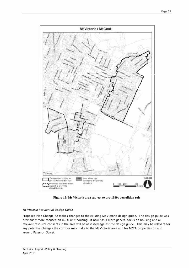
Page 57
Technical Report –Policy & Planning
April 2011
Figure 15: Mt Victoria area subject to pre-1930s demolition rule
Mt Victoria Residential Design Guide
Proposed Plan Change 72 makes changes to the existing Mt Victoria design guide. The design guide was
previously more focused on multi-unit housing. It now has a more general focus on housing and all
relevant resource consents in the area will be assessed against the design guide. This may be relevant for
any potential changes the corridor may make to the Mt Victoria area and for NZTA properties on and
around Paterson Street.
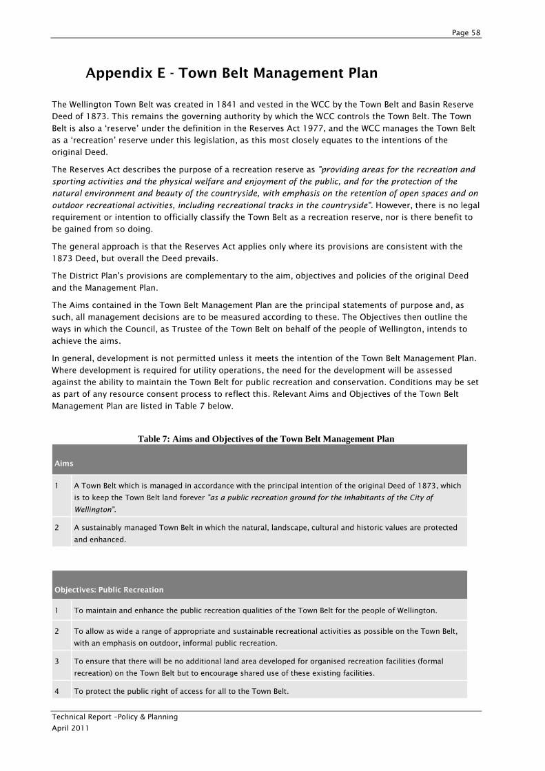
Page 58
Technical Report –Policy & Planning
April 2011
Appendix E - Town Belt Management Plan
The Wellington Town Belt was created in 1841 and vested in the WCC by the Town Belt and Basin Reserve
Deed of 1873. This remains the governing authority by which the WCC controls the Town Belt. The Town
Belt is also a ‘reserve’ under the definition in the Reserves Act 1977, and the WCC manages the Town Belt
as a ‘recreation’ reserve under this legislation, as this most closely equates to the intentions of the
original Deed.
The Reserves Act describes the purpose of a recreation reserve as "providing areas for the recreation and
sporting activities and the physical welfare and enjoyment of the public, and for the protection of the
natural environment and beauty of the countryside, with emphasis on the retention of open spaces and on
outdoor recreational activities, including recreational tracks in the countryside". However, there is no legal
requirement or intention to officially classify the Town Belt as a recreation reserve, nor is there benefit to
be gained from so doing.
The general approach is that the Reserves Act applies only where its provisions are consistent with the
1873 Deed, but overall the Deed prevails.
The District Plan's provisions are complementary to the aim, objectives and policies of the original Deed
and the Management Plan.
The Aims contained in the Town Belt Management Plan are the principal statements of purpose and, as
such, all management decisions are to be measured according to these. The Objectives then outline the
ways in which the Council, as Trustee of the Town Belt on behalf of the people of Wellington, intends to
achieve the aims.
In general, development is not permitted unless it meets the intention of the Town Belt Management Plan.
Where development is required for utility operations, the need for the development will be assessed
against the ability to maintain the Town Belt for public recreation and conservation. Conditions may be set
as part of any resource consent process to reflect this. Relevant Aims and Objectives of the Town Belt
Management Plan are listed in Table 7 below.
Table 7: Aims and Objectives of the Town Belt Management Plan
Aims
1 A Town Belt which is managed in accordance with the principal intention of the original Deed of 1873, which
is to keep the Town Belt land forever "as a public recreation ground for the inhabitants of the City of
Wellington".
2 A sustainably managed Town Belt in which the natural, landscape, cultural and historic values are protected
and enhanced.
Objectives: Public Recreation
1 To maintain and enhance the public recreation qualities of the Town Belt for the people of Wellington.
2 To allow as wide a range of appropriate and sustainable recreational activities as possible on the Town Belt,
with an emphasis on outdoor, informal public recreation.
3 To ensure that there will be no additional land area developed for organised recreation facilities (formal
recreation) on the Town Belt but to encourage shared use of these existing facilities.
4 To protect the public right of access for all to the Town Belt.
Page 59
Technical Report –Policy & Planning
April 2011
Objectives: Public Recreation
5 To promote the public recreational use of the Town Belt through the use of interpretive signs, access ways
and the dissemination of information on the recreational opportunities available within the Town Belt.
Objectives: Conservation and Land Management
6 To protect and enhance the landscape character, cultural and historic values and physical resources of the
Town Belt.
7 To manage the vegetation and conserve the water and soil resources of the Town Belt to ensure the
sustainable balance between the open land and the densely vegetated areas, the 'wild' areas and the
developed areas.
8 To maintain the Town Belt as an un-built visual backdrop and skyline to Wellington.
9 To gradually increase the proportion of native vegetation, to actively encourage the regeneration of the
native plant communities to their climax state and, where possible, to develop wildlife corridors to encourage
greater numbers and diversity of native wildlife.
10 To define the boundaries of the Town Belt on the ground.
11 To extend the Town Belt area by obtaining land that was originally part of the Town Belt but since alienated,
whenever opportunities arise, and by adding new areas which will enhance the Town Belt's public recreational
and 'green belt' qualities.
12 To only permit such development on the Town Belt as is required to achieve the objectives above or the
purposes of public utility and to specify the conditions under which this might take place.
Objectives: Administration
13 To integrate and balance conservation and recreation objectives.
14 To guide the decisions required to balance potentially conflicting uses on the Town Belt.
15 To encourage the community's active involvement in establishing and implementing the management plan to
protect the reserve status and the intrinsic values of the Town Belt.
16 To resolve the issues of encroachments with a view to regaining lost lands.
17 To protect the Town Belt from new encroachments.
Objective: Interpretation
18 To promote an awareness and appreciation of the unique status, landscape and recreational value of the
Town Belt, its ecological processes, its history and its unique identity and character.
Analysis of the Mt Victoria to Cobham Drive Project against these objectives and a number of other
supporting policies is provided in Table 8.
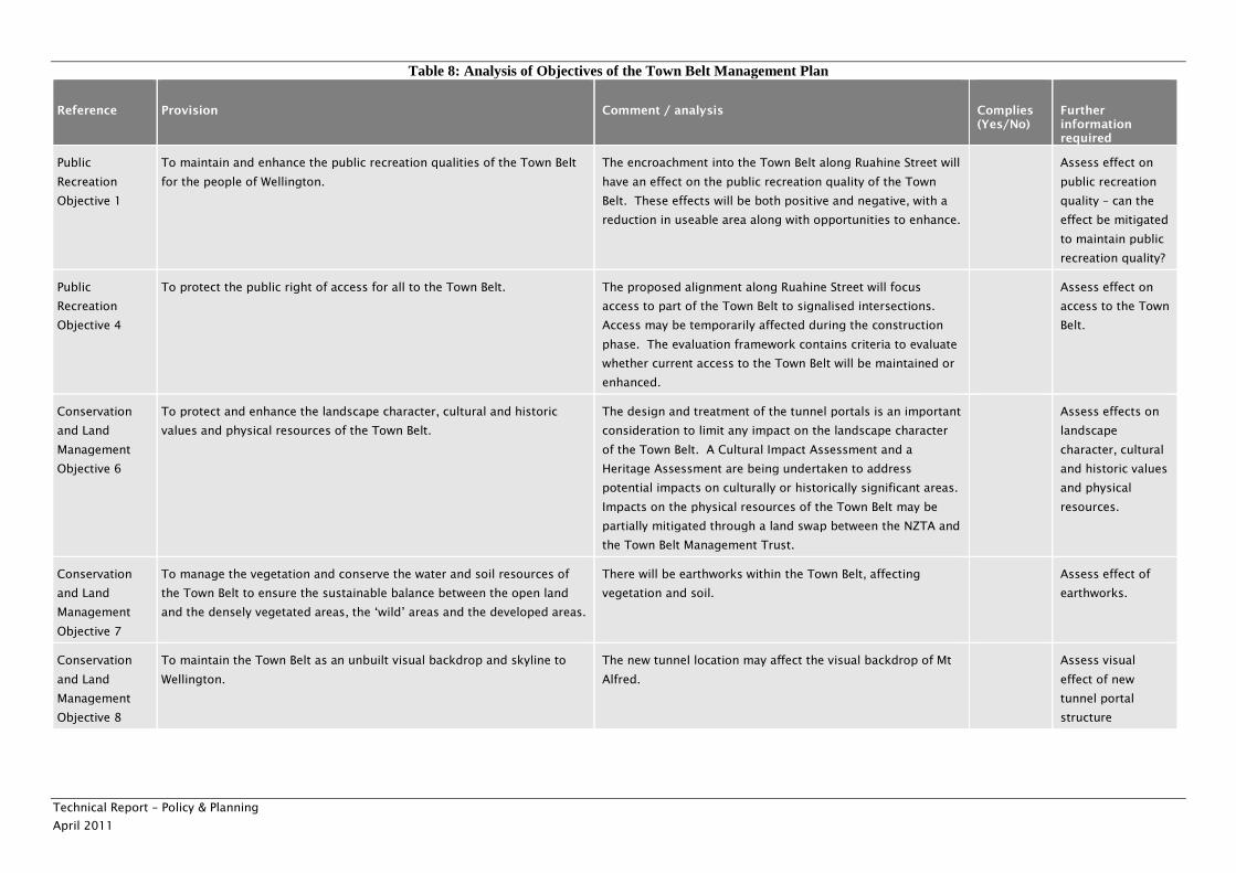
Technical Report – Policy & Planning
April 2011
Table 8: Analysis of Objectives of the Town Belt Management Plan
Reference Provision Comment / analysis Complies (Yes/No)
Further information required
Public
Recreation
Objective 1
To maintain and enhance the public recreation qualities of the Town Belt
for the people of Wellington.
The encroachment into the Town Belt along Ruahine Street will
have an effect on the public recreation quality of the Town
Belt. These effects will be both positive and negative, with a
reduction in useable area along with opportunities to enhance.
Assess effect on
public recreation
quality – can the
effect be mitigated
to maintain public
recreation quality?
Public
Recreation
Objective 4
To protect the public right of access for all to the Town Belt. The proposed alignment along Ruahine Street will focus
access to part of the Town Belt to signalised intersections.
Access may be temporarily affected during the construction
phase. The evaluation framework contains criteria to evaluate
whether current access to the Town Belt will be maintained or
enhanced.
Assess effect on
access to the Town
Belt.
Conservation
and Land
Management
Objective 6
To protect and enhance the landscape character, cultural and historic
values and physical resources of the Town Belt.
The design and treatment of the tunnel portals is an important
consideration to limit any impact on the landscape character
of the Town Belt. A Cultural Impact Assessment and a
Heritage Assessment are being undertaken to address
potential impacts on culturally or historically significant areas.
Impacts on the physical resources of the Town Belt may be
partially mitigated through a land swap between the NZTA and
the Town Belt Management Trust.
Assess effects on
landscape
character, cultural
and historic values
and physical
resources.
Conservation
and Land
Management
Objective 7
To manage the vegetation and conserve the water and soil resources of
the Town Belt to ensure the sustainable balance between the open land
and the densely vegetated areas, the ‘wild’ areas and the developed areas.
There will be earthworks within the Town Belt, affecting
vegetation and soil.
Assess effect of
earthworks.
Conservation
and Land
Management
Objective 8
To maintain the Town Belt as an unbuilt visual backdrop and skyline to
Wellington.
The new tunnel location may affect the visual backdrop of Mt
Alfred.
Assess visual
effect of new
tunnel portal
structure
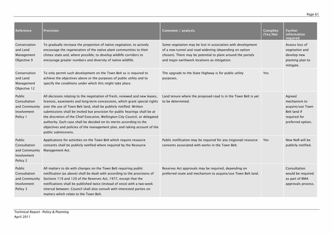
Page 61
Technical Report –Policy & Planning
April 2011
Reference Provision Comment / analysis Complies (Yes/No)
Further information required
Conservation
and Land
Management
Objective 9
To gradually increase the proportion of native vegetation, to actively
encourage the regeneration of the native plant communities to their
climax state and, where possible, to develop wildlife corridors to
encourage greater numbers and diversity of native wildlife.
Some vegetation may be lost in association with development
of a new tunnel and road widening (depending on option
chosen). There may be potential to plant around the portals
and major earthwork locations as mitigation.
Assess loss of
vegetation and
develop new
planting plan to
mitigate.
Conservation
and Land
Management
Objective 12
To only permit such development on the Town Belt as is required to
achieve the objectives above or the purposes of public utility and to
specify the conditions under which this might take place.
The upgrade to the State Highway is for public utility
purposes.
Yes
Public
Consultation
and Community
Involvement
Policy 1
All decisions relating to the negotiation of fresh, renewed and new leases,
licences, easements and long-term concessions, which grant special rights
over the use of Town Belt land, shall be publicly notified. Written
submissions shall be invited but provision for public hearings shall be at
the discretion of the Chief Executive, Wellington City Council, or delegated
authority. Each case shall be decided on its merits according to the
objectives and policies of the management plan, and taking account of the
public submissions.
Land tenure where the proposed road is in the Town Belt is yet
to be determined.
Agreed
mechanism to
acquire/use Town
Belt land if
required for
preferred option.
Public
Consultation
and Community
Involvement
Policy 2
Applications for activities on the Town Belt which require resource
consents shall be publicly notified where required by the Resource
Management Act.
Public notification may be required for any (regional) resource
consents associated with works in the Town Belt.
Yes New NoR will be
publicly notified.
Public
Consultation
and Community
Involvement
Policy 3
All matters to do with changes on the Town Belt requiring public
notification (as above) shall be dealt with according to the provisions of
Sections 119 and 120 of the Reserves Act, 1977, except that the
notifications shall be published twice (instead of once) with a two-week
interval between. Council shall also consult with interested parties on
matters which relate to the Town Belt.
Reserves Act approvals may be required, depending on
preferred route and mechanism to acquire/use Town Belt land.
Consultation
would be required
as part of RMA
approvals process.
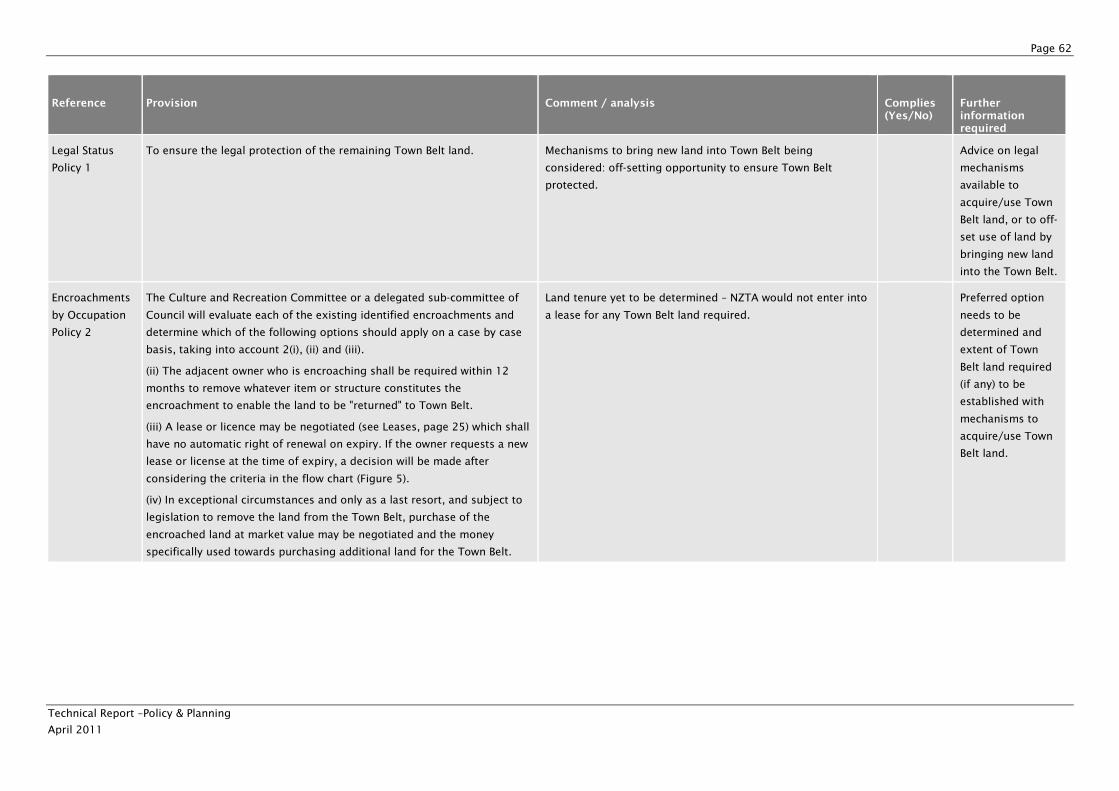
Page 62
Technical Report –Policy & Planning
April 2011
Reference Provision Comment / analysis Complies (Yes/No)
Further information required
Legal Status
Policy 1
To ensure the legal protection of the remaining Town Belt land. Mechanisms to bring new land into Town Belt being
considered: off-setting opportunity to ensure Town Belt
protected.
Advice on legal
mechanisms
available to
acquire/use Town
Belt land, or to off-
set use of land by
bringing new land
into the Town Belt.
Encroachments
by Occupation
Policy 2
The Culture and Recreation Committee or a delegated sub-committee of
Council will evaluate each of the existing identified encroachments and
determine which of the following options should apply on a case by case
basis, taking into account 2(i), (ii) and (iii).
(ii) The adjacent owner who is encroaching shall be required within 12
months to remove whatever item or structure constitutes the
encroachment to enable the land to be "returned" to Town Belt.
(iii) A lease or licence may be negotiated (see Leases, page 25) which shall
have no automatic right of renewal on expiry. If the owner requests a new
lease or license at the time of expiry, a decision will be made after
considering the criteria in the flow chart (Figure 5).
(iv) In exceptional circumstances and only as a last resort, and subject to
legislation to remove the land from the Town Belt, purchase of the
encroached land at market value may be negotiated and the money
specifically used towards purchasing additional land for the Town Belt.
Land tenure yet to be determined – NZTA would not enter into
a lease for any Town Belt land required.
Preferred option
needs to be
determined and
extent of Town
Belt land required
(if any) to be
established with
mechanisms to
acquire/use Town
Belt land.
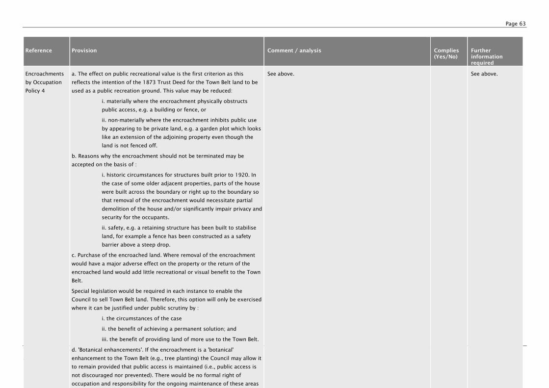
Page 63
Technical Report –Policy & Planning
April 2011
Reference Provision Comment / analysis Complies (Yes/No)
Further information required
Encroachments
by Occupation
Policy 4
a. The effect on public recreational value is the first criterion as this
reflects the intention of the 1873 Trust Deed for the Town Belt land to be
used as a public recreation ground. This value may be reduced:
i. materially where the encroachment physically obstructs
public access, e.g. a building or fence, or
ii. non-materially where the encroachment inhibits public use
by appearing to be private land, e.g. a garden plot which looks
like an extension of the adjoining property even though the
land is not fenced off.
b. Reasons why the encroachment should not be terminated may be
accepted on the basis of :
i. historic circumstances for structures built prior to 1920. In
the case of some older adjacent properties, parts of the house
were built across the boundary or right up to the boundary so
that removal of the encroachment would necessitate partial
demolition of the house and/or significantly impair privacy and
security for the occupants.
ii. safety, e.g. a retaining structure has been built to stabilise
land, for example a fence has been constructed as a safety
barrier above a steep drop.
c. Purchase of the encroached land. Where removal of the encroachment
would have a major adverse effect on the property or the return of the
encroached land would add little recreational or visual benefit to the Town
Belt.
Special legislation would be required in each instance to enable the
Council to sell Town Belt land. Therefore, this option will only be exercised
where it can be justified under public scrutiny by :
i. the circumstances of the case
ii. the benefit of achieving a permanent solution; and
iii. the benefit of providing land of more use to the Town Belt.
d. 'Botanical enhancements'. If the encroachment is a 'botanical'
enhancement to the Town Belt (e.g., tree planting) the Council may allow it
to remain provided that public access is maintained (i.e., public access is
not discouraged nor prevented). There would be no formal right of
occupation and responsibility for the ongoing maintenance of these areas
See above. See above.
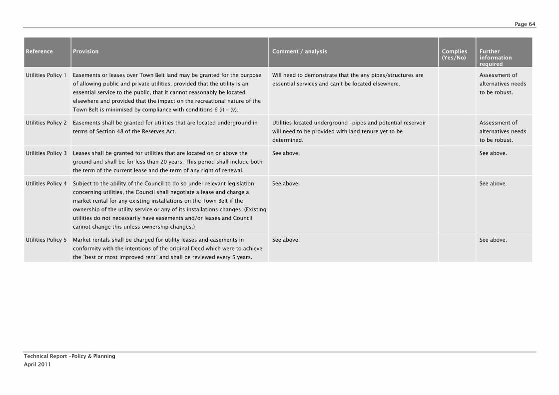
Page 64
Technical Report –Policy & Planning
April 2011
Reference Provision Comment / analysis Complies (Yes/No)
Further information required
Utilities Policy 1 Easements or leases over Town Belt land may be granted for the purpose
of allowing public and private utilities, provided that the utility is an
essential service to the public, that it cannot reasonably be located
elsewhere and provided that the impact on the recreational nature of the
Town Belt is minimised by compliance with conditions 6 (i) – (v).
Will need to demonstrate that the any pipes/structures are
essential services and can’t be located elsewhere.
Assessment of
alternatives needs
to be robust.
Utilities Policy 2 Easements shall be granted for utilities that are located underground in
terms of Section 48 of the Reserves Act.
Utilities located underground –pipes and potential reservoir
will need to be provided with land tenure yet to be
determined.
Assessment of
alternatives needs
to be robust.
Utilities Policy 3 Leases shall be granted for utilities that are located on or above the
ground and shall be for less than 20 years. This period shall include both
the term of the current lease and the term of any right of renewal.
See above. See above.
Utilities Policy 4 Subject to the ability of the Council to do so under relevant legislation
concerning utilities, the Council shall negotiate a lease and charge a
market rental for any existing installations on the Town Belt if the
ownership of the utility service or any of its installations changes. (Existing
utilities do not necessarily have easements and/or leases and Council
cannot change this unless ownership changes.)
See above. See above.
Utilities Policy 5 Market rentals shall be charged for utility leases and easements in
conformity with the intentions of the original Deed which were to achieve
the “best or most improved rent” and shall be reviewed every 5 years.
See above. See above.
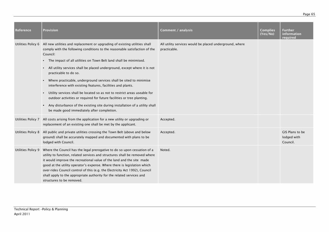
Page 65
Technical Report –Policy & Planning
April 2011
Reference Provision Comment / analysis Complies (Yes/No)
Further information required
Utilities Policy 6 All new utilities and replacement or upgrading of existing utilities shall
comply with the following conditions to the reasonable satisfaction of the
Council:
• The impact of all utilities on Town Belt land shall be minimised.
• All utility services shall be placed underground, except where it is not
practicable to do so.
• Where practicable, underground services shall be sited to minimise
interference with existing features, facilities and plants.
• Utility services shall be located so as not to restrict areas useable for
outdoor activities or required for future facilities or tree planting.
• Any disturbance of the existing site during installation of a utility shall
be made good immediately after completion.
All utility services would be placed underground, where
practicable.
Utilities Policy 7 All costs arising from the application for a new utility or upgrading or
replacement of an existing one shall be met by the applicant.
Accepted.
Utilities Policy 8 All public and private utilities crossing the Town Belt (above and below
ground) shall be accurately mapped and documented with plans to be
lodged with Council.
Accepted. GIS Plans to be
lodged with
Council.
Utilities Policy 9 Where the Council has the legal prerogative to do so upon cessation of a
utility to function, related services and structures shall be removed where
it would improve the recreational value of the land and the site made
good at the utility operator’s expense. Where there is legislation which
over-rides Council control of this (e.g. the Electricity Act 1992), Council
shall apply to the appropriate authority for the related services and
structures to be removed.
Noted.
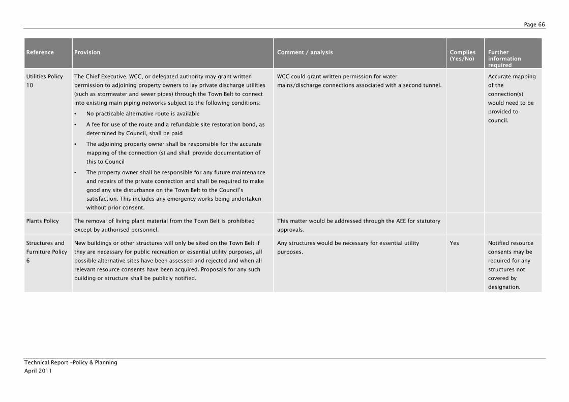
Page 66
Technical Report –Policy & Planning
April 2011
Reference Provision Comment / analysis Complies (Yes/No)
Further information required
Utilities Policy
10
The Chief Executive, WCC, or delegated authority may grant written
permission to adjoining property owners to lay private discharge utilities
(such as stormwater and sewer pipes) through the Town Belt to connect
into existing main piping networks subject to the following conditions:
• No practicable alternative route is available
• A fee for use of the route and a refundable site restoration bond, as
determined by Council, shall be paid
• The adjoining property owner shall be responsible for the accurate
mapping of the connection (s) and shall provide documentation of
this to Council
• The property owner shall be responsible for any future maintenance
and repairs of the private connection and shall be required to make
good any site disturbance on the Town Belt to the Council’s
satisfaction. This includes any emergency works being undertaken
without prior consent.
WCC could grant written permission for water
mains/discharge connections associated with a second tunnel.
Accurate mapping
of the
connection(s)
would need to be
provided to
council.
Plants Policy The removal of living plant material from the Town Belt is prohibited
except by authorised personnel.
This matter would be addressed through the AEE for statutory
approvals.
Structures and
Furniture Policy
6
New buildings or other structures will only be sited on the Town Belt if
they are necessary for public recreation or essential utility purposes, all
possible alternative sites have been assessed and rejected and when all
relevant resource consents have been acquired. Proposals for any such
building or structure shall be publicly notified.
Any structures would be necessary for essential utility
purposes.
Yes Notified resource
consents may be
required for any
structures not
covered by
designation.
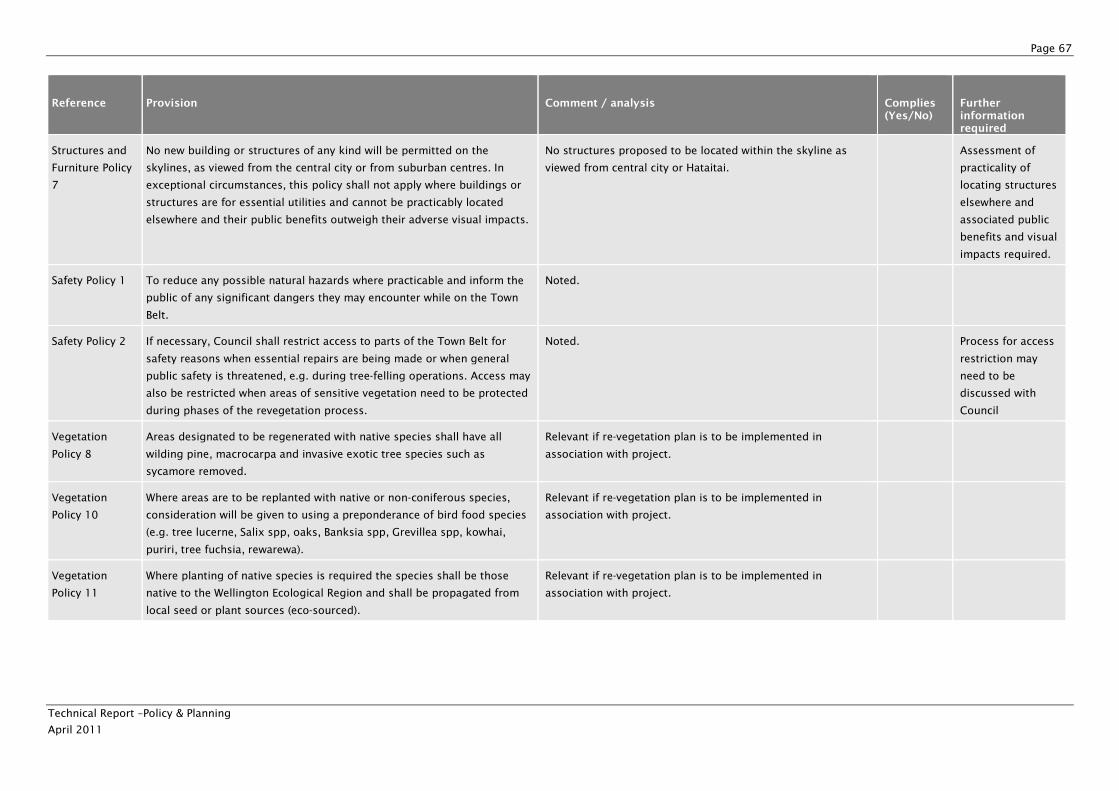
Page 67
Technical Report –Policy & Planning
April 2011
Reference Provision Comment / analysis Complies (Yes/No)
Further information required
Structures and
Furniture Policy
7
No new building or structures of any kind will be permitted on the
skylines, as viewed from the central city or from suburban centres. In
exceptional circumstances, this policy shall not apply where buildings or
structures are for essential utilities and cannot be practicably located
elsewhere and their public benefits outweigh their adverse visual impacts.
No structures proposed to be located within the skyline as
viewed from central city or Hataitai.
Assessment of
practicality of
locating structures
elsewhere and
associated public
benefits and visual
impacts required.
Safety Policy 1 To reduce any possible natural hazards where practicable and inform the
public of any significant dangers they may encounter while on the Town
Belt.
Noted.
Safety Policy 2 If necessary, Council shall restrict access to parts of the Town Belt for
safety reasons when essential repairs are being made or when general
public safety is threatened, e.g. during tree-felling operations. Access may
also be restricted when areas of sensitive vegetation need to be protected
during phases of the revegetation process.
Noted. Process for access
restriction may
need to be
discussed with
Council
Vegetation
Policy 8
Areas designated to be regenerated with native species shall have all
wilding pine, macrocarpa and invasive exotic tree species such as
sycamore removed.
Relevant if re-vegetation plan is to be implemented in
association with project.
Vegetation
Policy 10
Where areas are to be replanted with native or non-coniferous species,
consideration will be given to using a preponderance of bird food species
(e.g. tree lucerne, Salix spp, oaks, Banksia spp, Grevillea spp, kowhai,
puriri, tree fuchsia, rewarewa).
Relevant if re-vegetation plan is to be implemented in
association with project.
Vegetation
Policy 11
Where planting of native species is required the species shall be those
native to the Wellington Ecological Region and shall be propagated from
local seed or plant sources (eco-sourced).
Relevant if re-vegetation plan is to be implemented in
association with project.
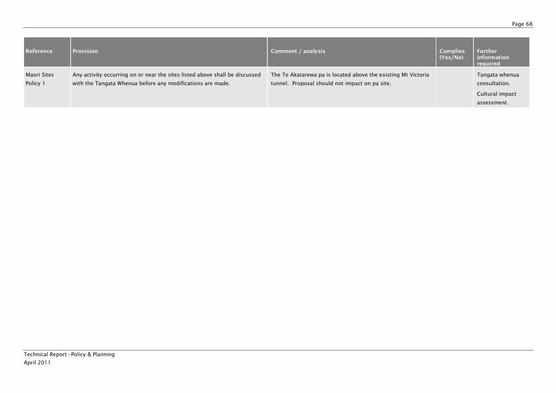
Page 68
Technical Report –Policy & Planning
April 2011
Reference Provision Comment / analysis Complies (Yes/No)
Further information required
Maori Sites
Policy 1
Any activity occurring on or near the sites listed above shall be discussed
with the Tangata Whenua before any modifications are made.
The Te Akatarewa pa is located above the existing Mt Victoria
tunnel. Proposal should not impact on pa site.
Tangata whenua
consultation.
Cultural impact
assessment.
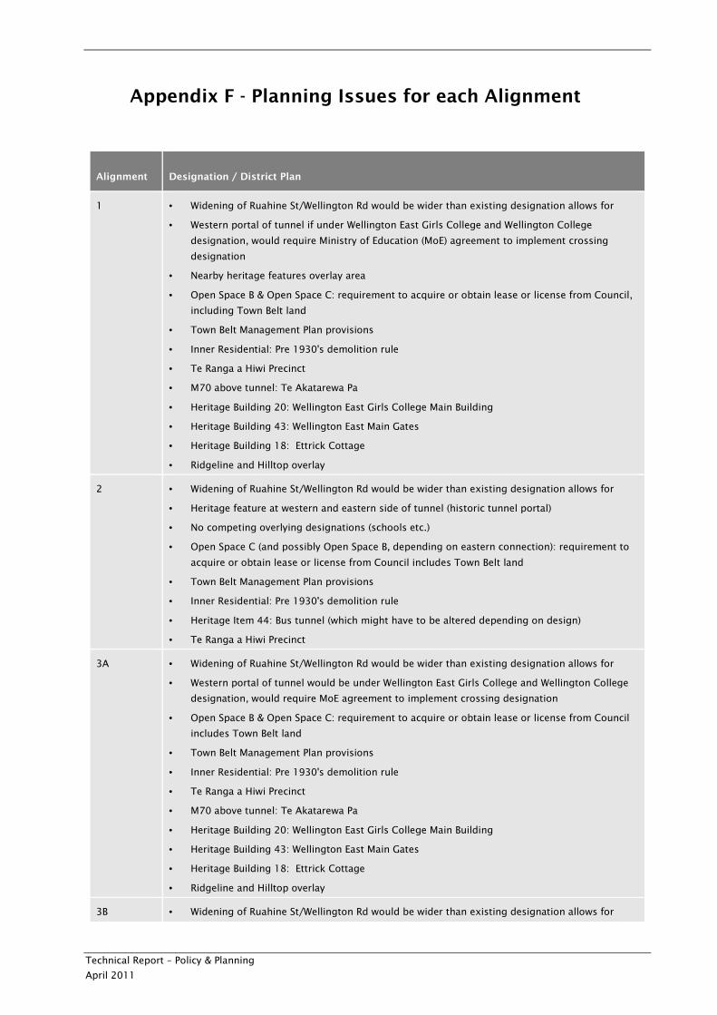
Technical Report – Policy & Planning
April 2011
Appendix F - Planning Issues for each Alignment
Alignment Designation / District Plan
1 • Widening of Ruahine St/Wellington Rd would be wider than existing designation allows for
• Western portal of tunnel if under Wellington East Girls College and Wellington College
designation, would require Ministry of Education (MoE) agreement to implement crossing
designation
• Nearby heritage features overlay area
• Open Space B & Open Space C: requirement to acquire or obtain lease or license from Council,
including Town Belt land
• Town Belt Management Plan provisions
• Inner Residential: Pre 1930's demolition rule
• Te Ranga a Hiwi Precinct
• M70 above tunnel: Te Akatarewa Pa
• Heritage Building 20: Wellington East Girls College Main Building
• Heritage Building 43: Wellington East Main Gates
• Heritage Building 18: Ettrick Cottage
• Ridgeline and Hilltop overlay
2 • Widening of Ruahine St/Wellington Rd would be wider than existing designation allows for
• Heritage feature at western and eastern side of tunnel (historic tunnel portal)
• No competing overlying designations (schools etc.)
• Open Space C (and possibly Open Space B, depending on eastern connection): requirement to
acquire or obtain lease or license from Council includes Town Belt land
• Town Belt Management Plan provisions
• Inner Residential: Pre 1930's demolition rule
• Heritage Item 44: Bus tunnel (which might have to be altered depending on design)
• Te Ranga a Hiwi Precinct
3A • Widening of Ruahine St/Wellington Rd would be wider than existing designation allows for
• Western portal of tunnel would be under Wellington East Girls College and Wellington College
designation, would require MoE agreement to implement crossing designation
• Open Space B & Open Space C: requirement to acquire or obtain lease or license from Council
includes Town Belt land
• Town Belt Management Plan provisions
• Inner Residential: Pre 1930's demolition rule
• Te Ranga a Hiwi Precinct
• M70 above tunnel: Te Akatarewa Pa
• Heritage Building 20: Wellington East Girls College Main Building
• Heritage Building 43: Wellington East Main Gates
• Heritage Building 18: Ettrick Cottage
• Ridgeline and Hilltop overlay
3B • Widening of Ruahine St/Wellington Rd would be wider than existing designation allows for
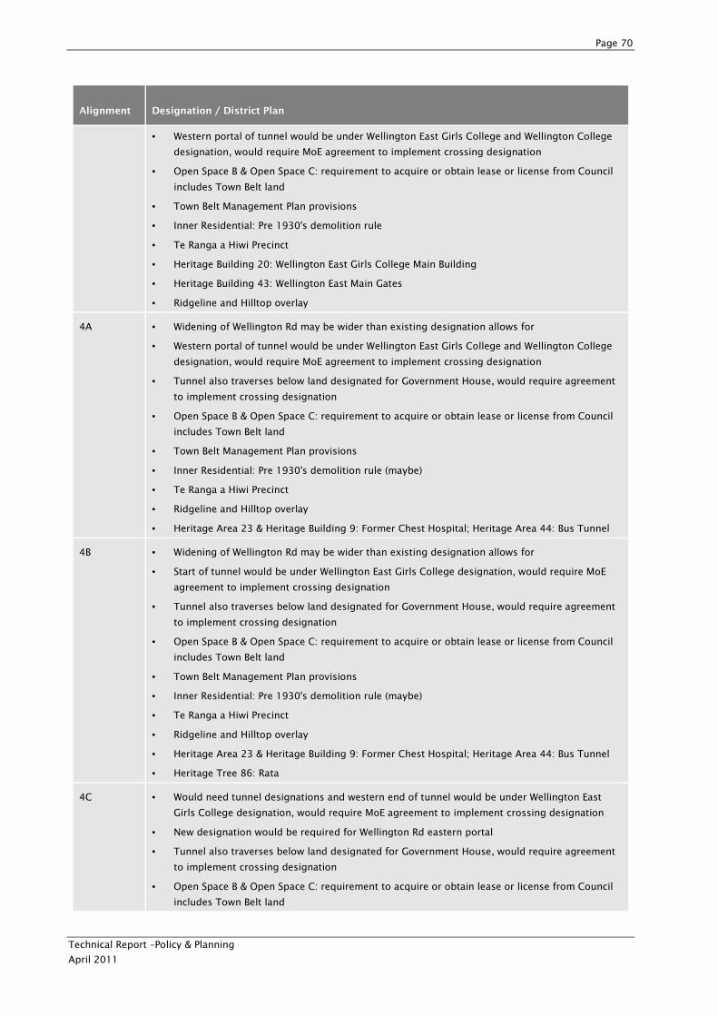
Page 70
Technical Report –Policy & Planning
April 2011
Alignment Designation / District Plan
• Western portal of tunnel would be under Wellington East Girls College and Wellington College
designation, would require MoE agreement to implement crossing designation
• Open Space B & Open Space C: requirement to acquire or obtain lease or license from Council
includes Town Belt land
• Town Belt Management Plan provisions
• Inner Residential: Pre 1930's demolition rule
• Te Ranga a Hiwi Precinct
• Heritage Building 20: Wellington East Girls College Main Building
• Heritage Building 43: Wellington East Main Gates
• Ridgeline and Hilltop overlay
4A • Widening of Wellington Rd may be wider than existing designation allows for
• Western portal of tunnel would be under Wellington East Girls College and Wellington College
designation, would require MoE agreement to implement crossing designation
• Tunnel also traverses below land designated for Government House, would require agreement
to implement crossing designation
• Open Space B & Open Space C: requirement to acquire or obtain lease or license from Council
includes Town Belt land
• Town Belt Management Plan provisions
• Inner Residential: Pre 1930's demolition rule (maybe)
• Te Ranga a Hiwi Precinct
• Ridgeline and Hilltop overlay
• Heritage Area 23 & Heritage Building 9: Former Chest Hospital; Heritage Area 44: Bus Tunnel
4B • Widening of Wellington Rd may be wider than existing designation allows for
• Start of tunnel would be under Wellington East Girls College designation, would require MoE
agreement to implement crossing designation
• Tunnel also traverses below land designated for Government House, would require agreement
to implement crossing designation
• Open Space B & Open Space C: requirement to acquire or obtain lease or license from Council
includes Town Belt land
• Town Belt Management Plan provisions
• Inner Residential: Pre 1930's demolition rule (maybe)
• Te Ranga a Hiwi Precinct
• Ridgeline and Hilltop overlay
• Heritage Area 23 & Heritage Building 9: Former Chest Hospital; Heritage Area 44: Bus Tunnel
• Heritage Tree 86: Rata
4C • Would need tunnel designations and western end of tunnel would be under Wellington East
Girls College designation, would require MoE agreement to implement crossing designation
• New designation would be required for Wellington Rd eastern portal
• Tunnel also traverses below land designated for Government House, would require agreement
to implement crossing designation
• Open Space B & Open Space C: requirement to acquire or obtain lease or license from Council
includes Town Belt land
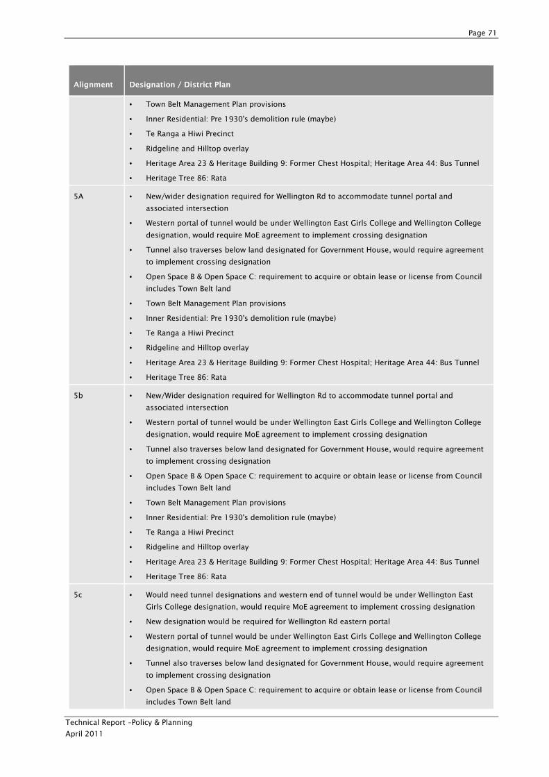
Page 71
Technical Report –Policy & Planning
April 2011
Alignment Designation / District Plan
• Town Belt Management Plan provisions
• Inner Residential: Pre 1930's demolition rule (maybe)
• Te Ranga a Hiwi Precinct
• Ridgeline and Hilltop overlay
• Heritage Area 23 & Heritage Building 9: Former Chest Hospital; Heritage Area 44: Bus Tunnel
• Heritage Tree 86: Rata
5A • New/wider designation required for Wellington Rd to accommodate tunnel portal and
associated intersection
• Western portal of tunnel would be under Wellington East Girls College and Wellington College
designation, would require MoE agreement to implement crossing designation
• Tunnel also traverses below land designated for Government House, would require agreement
to implement crossing designation
• Open Space B & Open Space C: requirement to acquire or obtain lease or license from Council
includes Town Belt land
• Town Belt Management Plan provisions
• Inner Residential: Pre 1930's demolition rule (maybe)
• Te Ranga a Hiwi Precinct
• Ridgeline and Hilltop overlay
• Heritage Area 23 & Heritage Building 9: Former Chest Hospital; Heritage Area 44: Bus Tunnel
• Heritage Tree 86: Rata
5b • New/Wider designation required for Wellington Rd to accommodate tunnel portal and
associated intersection
• Western portal of tunnel would be under Wellington East Girls College and Wellington College
designation, would require MoE agreement to implement crossing designation
• Tunnel also traverses below land designated for Government House, would require agreement
to implement crossing designation
• Open Space B & Open Space C: requirement to acquire or obtain lease or license from Council
includes Town Belt land
• Town Belt Management Plan provisions
• Inner Residential: Pre 1930's demolition rule (maybe)
• Te Ranga a Hiwi Precinct
• Ridgeline and Hilltop overlay
• Heritage Area 23 & Heritage Building 9: Former Chest Hospital; Heritage Area 44: Bus Tunnel
• Heritage Tree 86: Rata
5c • Would need tunnel designations and western end of tunnel would be under Wellington East
Girls College designation, would require MoE agreement to implement crossing designation
• New designation would be required for Wellington Rd eastern portal
• Western portal of tunnel would be under Wellington East Girls College and Wellington College
designation, would require MoE agreement to implement crossing designation
• Tunnel also traverses below land designated for Government House, would require agreement
to implement crossing designation
• Open Space B & Open Space C: requirement to acquire or obtain lease or license from Council
includes Town Belt land
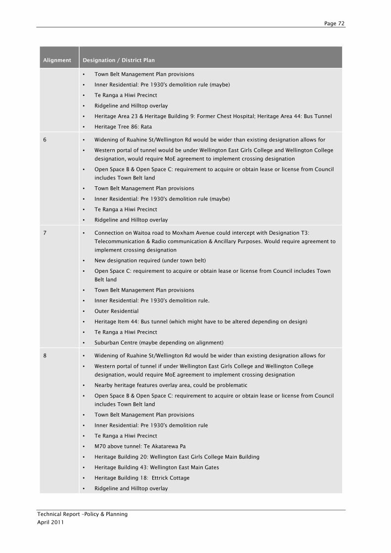
Page 72
Technical Report –Policy & Planning
April 2011
Alignment Designation / District Plan
• Town Belt Management Plan provisions
• Inner Residential: Pre 1930's demolition rule (maybe)
• Te Ranga a Hiwi Precinct
• Ridgeline and Hilltop overlay
• Heritage Area 23 & Heritage Building 9: Former Chest Hospital; Heritage Area 44: Bus Tunnel
• Heritage Tree 86: Rata
6 • Widening of Ruahine St/Wellington Rd would be wider than existing designation allows for
• Western portal of tunnel would be under Wellington East Girls College and Wellington College
designation, would require MoE agreement to implement crossing designation
• Open Space B & Open Space C: requirement to acquire or obtain lease or license from Council
includes Town Belt land
• Town Belt Management Plan provisions
• Inner Residential: Pre 1930's demolition rule (maybe)
• Te Ranga a Hiwi Precinct
• Ridgeline and Hilltop overlay
7 • Connection on Waitoa road to Moxham Avenue could intercept with Designation T3:
Telecommunication & Radio communication & Ancillary Purposes. Would require agreement to
implement crossing designation
• New designation required (under town belt)
• Open Space C: requirement to acquire or obtain lease or license from Council includes Town
Belt land
• Town Belt Management Plan provisions
• Inner Residential: Pre 1930's demolition rule.
• Outer Residential
• Heritage Item 44: Bus tunnel (which might have to be altered depending on design)
• Te Ranga a Hiwi Precinct
• Suburban Centre (maybe depending on alignment)
8 • Widening of Ruahine St/Wellington Rd would be wider than existing designation allows for
• Western portal of tunnel if under Wellington East Girls College and Wellington College
designation, would require MoE agreement to implement crossing designation
• Nearby heritage features overlay area, could be problematic
• Open Space B & Open Space C: requirement to acquire or obtain lease or license from Council
includes Town Belt land
• Town Belt Management Plan provisions
• Inner Residential: Pre 1930's demolition rule
• Te Ranga a Hiwi Precinct
• M70 above tunnel: Te Akatarewa Pa
• Heritage Building 20: Wellington East Girls College Main Building
• Heritage Building 43: Wellington East Main Gates
• Heritage Building 18: Ettrick Cottage
• Ridgeline and Hilltop overlay
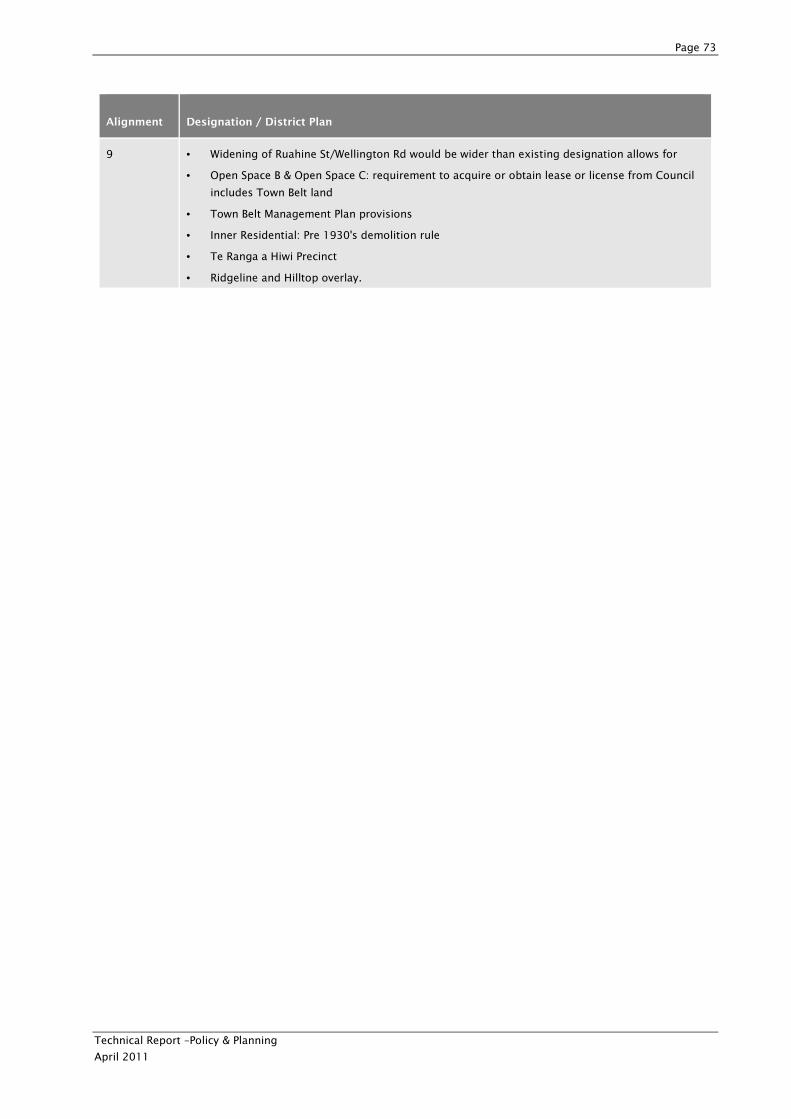
Page 73
Technical Report –Policy & Planning
April 2011
Alignment Designation / District Plan
9 • Widening of Ruahine St/Wellington Rd would be wider than existing designation allows for
• Open Space B & Open Space C: requirement to acquire or obtain lease or license from Council
includes Town Belt land
• Town Belt Management Plan provisions
• Inner Residential: Pre 1930's demolition rule
• Te Ranga a Hiwi Precinct
• Ridgeline and Hilltop overlay.