Embed Size (px)
Citation preview

1
MÁSTER EN DISEÑO URBANO: ARTE, CIUDAD, SOCIEDAD IMPROVING THE CITY IMAGE OF RIYADH THROUGH STOREFRONT AND STREET SIGNAGE REDESIGN Tutor Dr. A. Remesar Author Sama AlMalik

IMPROVING THE CITY IMAGE OF RIYADH S. AlMalik THROUGH STOREFRONT AND STREET SIGNAGE REDESIGN
2

IMPROVING THE CITY IMAGE OF RIYADH S. AlMalik THROUGH STOREFRONT AND STREET SIGNAGE REDESIGN
3
MÁSTER EN DISEÑO URBANO: ARTE, CIUDAD, SOCIEDAD IMPROVING THE CITY IMAGE OF RIYADH THROUGH STOREFRONT AND STREET SIGNAGE REDESIGN Tutor Dr. Antoni Remesar Author Sama AlMalik NUIB 15847882 Academic Year 2016-2017 Submitted in the support of the degree of Masters in Urban Design

IMPROVING THE CITY IMAGE OF RIYADH S. AlMalik THROUGH STOREFRONT AND STREET SIGNAGE REDESIGN
4

IMPROVING THE CITY IMAGE OF RIYADH S. AlMalik THROUGH STOREFRONT AND STREET SIGNAGE REDESIGN
5
RESUMEN Las calles, barrios y ciudades de Arabia Saudita se encuentran en un estado de construcción permanente desde hace varias décadas, incentivando a la población de a adaptarse al cambio y la transformación, a estar abiertos a cambios constantes, a anticipar la magnitud de desarrollos futuros y a anhelar que el futuro se convierta en presente. El futuro, como se describe en la Visión 2030 del Príncipe Heredero Mohammed bin Salman Al Saud, promete tres objetivos principales: una economía próspera, una sociedad vibrante y una nación ambiciosa. Afortunadamente, para la capital, Riad, varios proyectos se están acercando a su finalización, haciendo cambios significativos en las calles, imagen y perfil de la ciudad. Esto configura cómo los ciudadanos interactúan con toda la ciudad, cómo se integran y reconocen nuevas calles, edificios y distritos. La actualización de los sistemas de señalización de tráfico es esencial para mejorar la movilidad. Sin embargo, afecta a la imagen y al carácter de la ciudad, exponiéndola a tomar una de dos direcciones, una sugiere un efecto positivo, mayor claridad y comodidad, mejora seguridad para los conductores, pasajeros, peatones y civiles. La otra incita efectos negativos, ya que este tipo de adiciones contaminan la arquitectura y la ciudad visualmente, distraen a los conductores y, en consecuencia, disminuyen la singularidad y la individualidad de la imagen de la ciudad. La necesidad elevada por el desarrollo de infraestructura, con un énfasis en el sistema de transporte público, ha desafiado el nivel de tolerancia de la gente del Reino. Sin embargo, teniendo en cuenta estos factores, el gobierno está en una posición privilegiada para impulsar más cambios. Una iniciativa para cambiar la señalización, las políticas y normativas de publicidad puede ser comunicada de manera suave, progresiva y conveniente a los propietarios de tiendas, anunciantes y empresas. El resultado será una disminución en la cantidad de contaminación visual causada por la señalización y la publicidad afectando la imagen de la ciudad; mejorando y embelleciendo edificaciones y estructuras que queden limpias de todas las pantallas gráficas que se encuentran en el plano vertical de la ciudad. PALABRAS CLAVE Señalización, Señalética, Publicidad, Plano Vertical, Imagen de la ciudad, Identidad, Contaminación Visual

IMPROVING THE CITY IMAGE OF RIYADH S. AlMalik THROUGH STOREFRONT AND STREET SIGNAGE REDESIGN
6

IMPROVING THE CITY IMAGE OF RIYADH S. AlMalik THROUGH STOREFRONT AND STREET SIGNAGE REDESIGN
7
ABSTRACT The streets, neighbourhoods, and cities of Saudi Arabia are under construction, and have been for the past several decades, pushing the Saudi population to adapt to change, be open to adjustments, anticipate the magnitude of future developments, and be eager for the future to become the present. The future, as described in Deputy Crown Prince Mohammed bin Salman Al Saud’s Vision 20301, promises three main goals: a thriving economy, a vibrant society and an ambitious nation. Fortunately for the capital, Riyadh, multiple projects are approaching completion, making significant alterations to the city’s streets, image and skyline. This shapes how citizens commute throughout the city and how new streets, buildings and districts are registered and recognized. Updated traffic signalling systems were essential to improved navigation. They do however affect the city’s image and character, pushing it in one of two directions, the first instigating a positive effect, greater clarity, and convenience, improved safety to drivers, passengers, pedestrians and civilians in general. The second prompting negative effects, as the additions taint architecture, contaminate the city visually, distract drivers, and consequently diminish the uniqueness and individuality of the city image. The process of making highly needed infrastructural developments – with an emphasis on the public transportation system – has challenged the level of tolerance for change of the people of the Kingdom. Nevertheless, with these factors taken into consideration, the government is in an advantageous position to push for more changes. An initiative to change signage and public advertising regulations can be communicated smoothly, progressively and conveniently - to shop owners, advertisers and companies. The result will be a decrease in the amount of visual contamination caused by signage and advertisement affecting city image and improvements resulting from a clear structure for all graphic displays found on the city’s vertical plane. KEYWORDS Signage, Advertisement, Vertical Plane, City Image, Identity, Visual Contamination
1 Vision 2030 Deputy Crown Prince Mohammed bin Salman AlSaud: Saudi Arabia… the heart of the Arab and Islamic worlds, the
investment powerhouse, and the hub connecting three continents

IMPROVING THE CITY IMAGE OF RIYADH S. AlMalik THROUGH STOREFRONT AND STREET SIGNAGE REDESIGN
8
IMPROVING THE CITY IMAGE OF RIYADH S. AlMalik THROUGH STOREFRONT AND STREET SIGNAGE REDESIGN
9
TABLE OF CONTENT
RESUMEN 5
ABSTRACT 7
KEYWORDS 7
THE KINGDOM OF SAUDI ARABIA 11
REASEARCH OBJECTIVES 13
METHODOLOGY 14 THE KINGDOM OF SAUDI ARABIA 16 HISTORICAL OVERVIEW 16
THE HOUSE OF SAUD & THE KINGDOM OF SAUDI ARABIA 23
RIYADH 25 ARCHITECTURE AND URBAN DEVELOPMENT 26
LITERATURE REVIEW 41
URBAN DECORUM 43
URBAN COHESION 45
CITY IMAGE AND THE IMAGE OF A CITY 46
ANALYSIS 57
QUESTIONNAIRE 59 ANALYSIS OF DED’S EFFORT TO IMPROVE SIGNBOARDS IN ABU DHABI 66 ANALYSIS OF ADA’S EFFORT TO IMPROVE SIGNBOARDS IN RIYADH 73
PROPOSAL 83
CONCLUSION 91
BIBLIOGRAPHY & APPENDICES 95
BIBLIOGRAPHY 97 INDEX OF IMAGES 105 I SEE YOU RIYADH - OMAIMA ALAZHARI 108 DEFINITIONS AND TERMINOLOGY OF RELEVANT ARABIC VOCABULARY AND TERMS 109 QUESTIONNAIRE DISTRIBUTED NOVEMBER 2016 AMONGST 904 PARTICIPANTS. 111

IMPROVING THE CITY IMAGE OF RIYADH S. AlMalik THROUGH STOREFRONT AND STREET SIGNAGE REDESIGN
10

IMPROVING THE CITY IMAGE OF RIYADH S. AlMalik THROUGH STOREFRONT AND STREET SIGNAGE REDESIGN
11
CHAPTER I THE KINGDOM OF SAUDI ARABIA

IMPROVING THE CITY IMAGE OF RIYADH S. AlMalik THROUGH STOREFRONT AND STREET SIGNAGE REDESIGN
12

IMPROVING THE CITY IMAGE OF RIYADH S. AlMalik THROUGH STOREFRONT AND STREET SIGNAGE REDESIGN
13
INTRODUCTION The Middle East has been booming for the past couple of decades with massive development, architectural and master planning projects. Saudi Arabia, one of the largest countries of the region, currently hosts the largest number with a budget of $1.2 trillion for projects either planned or underway. (Newsmanager, 2014). Fortunately, several world-renowned architects have taken part in the design of important buildings and master planning projects throughout the country since the 1960s— Kenzo Tange, Henning Larsen, Zaha Hadid, Snohetta, Atkins, as well as Foster + Partners, to name a few. Significant projects can be found in different areas across Riyadh, the capital of Saudi Arabia. The city is recognized as among the world’s fifty fastest growing urban areas. (Citymayors, 2016) Newly designed systems of public transportation, a financial district, multiple research centres and new university campuses are examples of the projects under construction. The contributions of the architects mentioned above have sculpted a modern metropolis skyline over a period of half a century, reshaping Riyadh entirely into the capital of the Kingdom it is today. The combined efforts are bringing the city as well as the country as a whole, closer to the 2030 vision of King Salman bin AbdulAziz, the Custodian of the Two Holy Mosques, who envisions Saudi Arabia as: “the heart of the Arab and Islamic worlds, an investment powerhouse, and a hub connecting three continents”. (Saudi Vision 2030,2016).
Figure 1 Riyadh Skyline, Timeline - Omaima AlAzhari
REASEARCH OBJECTIVES The aim of this M.A. dissertation is to explore ways that the city can maintain its cultural heritage while sustaining a cohesive image and style throughout the city via its architecture, public spaces, social areas, commercial centres, activity zones all in a unified harmony. A further goal is to create new solutions to control street signage and advertising signboards as well as incorporate artistic elements that bring together local, regional and foreign expertise. The result will be a well-planned city, tailored to its citizens’ needs, easy to navigate, harmonized in its overall urban design, and subsequently reinforcing the Kingdom founder, King AbdulAziz’s ambition to building a modern civilization with unparalleled luxury and service offered to the country’s citizens.

IMPROVING THE CITY IMAGE OF RIYADH S. AlMalik THROUGH STOREFRONT AND STREET SIGNAGE REDESIGN
14
METHODOLOGY This study was conducted using a combination of methods to produce an approach for developing Riyadh’s city image and vertical plane. The redesign proposal has been formulated by studying the city’s architectural and urban trajectory from the perspective of three periods of growth. This was complemented by data collection with input from local residents of different backgrounds, social status, educational levels, nationality, gender, and age. Additionally, studies done by the municipalities of Riyadh and Abu Dhabi— two different design development projects executed specifically for the purpose of decluttering the vertical planes of each city and limiting overcrowded advertising—were reviewed. Barcelona is used as a point of reference and model city that has developed yet maintained and preserved its city image it is and studied briefly and referred to in many occasions throughout the dissertation. To clarify, following methodological patterns were established during the study: Analysis of City’s Architectural and Urban Morphological Development
Riyadh has been on a trajectory of rapid development since King AbdulAziz first designated it capital of Saudi Arabia. The city was established as the country’s administrative hub due to location of the royal palace, numerous ministries, embassies, universities, and research centres. This notably affected its urban growth, its political importance, and its artistic façade. Investigation of Multiple Urban Design Elements
Multiple urban design elements affect the urban identity visually and can have significant social impact. This includes accepting definitions of various identity and metropolitan design elements such as the vertical plane, symbolism, place attachment, urban cohesion as defined by Lynch (1960, 1981), Jacobs (1961), Remesar (Remesar A, 2011; Ricart N; Remesar A 2012; Remesar A, Ríos M, 2015) , and Brandão (2011; 211a) and the strategies they have developed to better understand the effects past characteristics of urban cohesion have on future construction. Exploration of a Questionnaire Directed Specifically to Riyadh Locals
A total of 22 questions, in both the Arabic and English were distributed to 904 local residents of Riyadh via various social media platforms. The results then were gathered by Survey Monkey and analysed to get a comprehensive view of what locals notice, enjoy, lack, and desire for their city, as well as, what they notice, enjoy and are inspired by when traveling. The questions were set to demonstrate the effect signage has on local citizens. Moreover, the display of how the civilians feel towards the visual elements on the vertical planes, their knowledge and stance regarding civil responsibilities, also, the differences noted while traveling. It also demonstrates the prominence of traveling in the Saudi culture. The Review of the Rehabilitation Project Riyadh 2013
A comparative analysis was completed of the rehabilitation project in Riyadh implemented in 2013 and the redesign project accomplished in Abu Dhabi in 2012 that considered the preliminary study, research, implementation and practicality of each proposal regarding its impact on affected shops, companies, and advertising agencies.

IMPROVING THE CITY IMAGE OF RIYADH S. AlMalik THROUGH STOREFRONT AND STREET SIGNAGE REDESIGN
15
Furthermore, the analysis considered why Riyadh’s proposal failed to evolve or maintain its desired level of design against why and how Abu Dhabi successfully continues to maintain its new advertising regulations and protect the city’s image. Timeframe and sequence of the research
Research for this thesis included studying the architectural and infrastructure evolution of Riyadh, an investigation into the alignment of advertisement and signboards with the city’s past and current trends of architecture and street design and research into updated regulations that correlated with the prospective development plans. The study concludes with a proposal to be implemented during building and construction to avoid delays in project completion phases and termination dates. Limitations
The main limitation of this study was the absence of updated government regulations to limit advertising, guidelines such as size, materials, colours, location. There are unclear and outdated regulations that are no longer applicable to the marketing technology or mechanisms of the present day. The study of different cities including, Barcelona and Abu Dhabi helped narrow options and inform more suitable suggestions to consider architecture appropriately.

IMPROVING THE CITY IMAGE OF RIYADH S. AlMalik THROUGH STOREFRONT AND STREET SIGNAGE REDESIGN
16
THE KINGDOM OF SAUDI ARABIA Historical Overview In the year 610 C.E., Mohammed, a successful and trusted merchant in Mecca, received a message from Allah2 through an angel revealing him as the chosen prophet of a new religion, Islam. Twelve years later, Mohammed together with a group of recently converted followers, were forced from Mecca and migrated to Medina, known in 622 C.E as Yathrib. The exodus from Mecca is known in Arabic as Al Hijra3. Today, the first day of Muharram4 marks the day Al Hijra introduced the Islamic calendar5. Medina’s population was entirely Muslim by 628 C.E. During that decade, several battles between the Prophet and the pagans of Mecca took place until they re-entered the city and claimed Mecca as their capital, accomplishing this peacefully (Saudi Arabia, N.D.). Within a century, the succeeding Islamic caliphates - Rashidun, Umayyad, Abbasid, the Ayyubid dynasty, the Mamluk and Ottoman caliphates - had spread out to form the great Islamic empire, reaching the Iberian Peninsula, parts of India and China (Saudi Arabia, 2016). Pilgrims began to visit Mecca regularly, resulting in the growth of trade and business throughout the Muslim world. The pilgrimage successively improved existing commercial routes, expanding them throughout three continents—Asia, Europe and Africa. Local populations exchanged ideas, cultures and civilisation with pilgrims and visitors that contributed to growing similarities amongst the Muslim and Arab world and impacting the various languages. Sciences advanced in the Golden Age of Muslim scholars. Their contribution to medicine, biology, astronomy, philosophy, architecture, arts and literature all contributed to a prosperous civilization that nowadays is considered to have been the foundation of modern science. Later in the 17th Century, the Ottoman Empire gradually dissolved into smaller kingdoms and nations. Despite the wars, politics and conflict, Mecca and Medina maintained their religious importance throughout this history and assumed permanent responsibility for the safety of pilgrims, a massive flow of visitors that continues to this day. (AlsharqAlawsat, 2008)
Figure 2. The Islamic Empire 750 C.E.
2 Allah, the first of the ninety-nine Arabic names of God
3 Al-Hijra is the day prophet Mohammad emigrated from Mecca to Medina. It also marks the Islamic New Year.
4 Muharram is the Arabic name of the first month in the Islamic calendar, it is one of the four sacred months.
5 The Islamic calendar also known as, the Hijri calendar relies solely on lunar motion. Containing 12 months of 29.53 days, multiplied to a
total of 354.36 days, making the year in an Islamic calendar consistently shorter than that of a Gregorian year.
Expansion map during: Prophet Mohammed Rashidun Caliphate Umayyad Caliphate

IMPROVING THE CITY IMAGE OF RIYADH S. AlMalik THROUGH STOREFRONT AND STREET SIGNAGE REDESIGN
17
The following list shows the caliphates and their capitals, after Prophet Mohammed with images showing prominent architectural styles of each reign that spread throughout the Islamic lands (Thesaudinet, 2014):
§ 632 - 661 C.E. The Rashidun Caliphate, Mecca § 661 - 750 C.E. The Umayyad Caliphate, Damascus
o 756 - 1031 C.E. Umayyad Caliphate of Cordoba, Spain § 750 - 1258 C.E. The Abbasid Caliphate, Baghdad, Samarra, Cairo § 900 - 1171 C.E. The Fatimid Caliphate, Cairo § 1171 - 1260 C.E. The Ayyubid Dynasty, Cairo, Aleppo § 1250 - 1517 C.E. The Mamluk Caliphate, Cairo § 1517 - 1823 C.E. The Ottoman Empire, Constantinople (Istanbul)
Just as trade introduced new knowledge, spices and terminology; new-fangled building techniques, materials, and architectural advancements were familiarised to the Islamic world with each caliphate’s new conquering. The development of mathematics had an impactful influence on architecture creating repetitive decorative motifs that are found in the ancient mosques and palaces built from the Great Mosque of Xian in China, to the Al Hambra Fortress in Andalusia, Spain (Yalman, 2001).
Figure 3 The Great Mosque of Xi'an, China -Rashidun Caliphate Figure 4 Ibn Tulun Mosque, Cairo -Abbasid Caliphate
Figure 5 Al Hambra Fortress, Andalusia, Spain -Umayyad Caliphate Figure 6 The Great Mosque of Samarra, Iraq -Abbasid Caliphate

IMPROVING THE CITY IMAGE OF RIYADH S. AlMalik THROUGH STOREFRONT AND STREET SIGNAGE REDESIGN
18
Figure 7 AlAzhar Mosque and University, Cairo -Fatimid Caliphate Figure 8 Funerary of Sultan Qaytbay, Cairo –Mamluk Caliphate
As urbanization expanded from one caliphate to the next, cities and capitals continued to grow in a winding organic manner. Rural areas outside city walls were typically slums, cemeteries or waste sites. Mosques and military campgrounds were allocated near city main gates, and were used during religious celebrations and open executions (Islamic History, n.d.). Water and drainage systems were in constant development, fountains and channelled drinking supplied water to private and public facilities, improving the agriculture and gardens of the golden era. In the year 740 C.E. the great mosque of Xi’an was completed (figure 2), a century later the Abbasid capital Samarra6Great Mosque (figure 5) was built combining different adopted styles of architecture including rows of columns that supported the flat ceiling and a spiralling minaret7. Soon after the Muslims in Spain began constructing the Great Mosque in Cordoba and the Alhambra palace and fort in Andalusia. Many of the architecture and interiors were heavily ornamented with arabesque designs, foliage motifs, and stylized with Arabic calligraphy with verses from the Quran and prayers. In Turkey, the Ottoman empire had constructed massive mosques including Süleymaniye Mosque, and Bayezid II Mosque (Islamic History, n.d.). Starting from the year 750 C.E. until 1500 C.E. the golden age of Islamic art was flourishing with glass, ceramics, fabrics and metalwork. Manuscripts and calligraphy blossomed into an important and greatly respected art, and was constantly found used in different styles and fonts customizing architecture and interiors (Islamic History, n.d). Arches, columns and domes became prominent characteristics of Islamic architecture, repeatedly found in mosques. Soon after the Ottoman empire had declined the Gulf area was divided into various states, ruled by multiple families and tribes. Kuwait, Bahrain, Qatar, The Emirates, Oman, Yemen, to name a few. In addition to the scattered states within the peninsula, to name a few; Najd, AlQassim, AlHijaz, Aseer, Najran, and Hael (figure 8). The central and eastern areas of the peninsula were generally vast dessert lands where caravans and nomadic tribes travelled constantly in search for trade and/or en-route to perform Hajj, the Islamic pilgrimage. (Saudi Arabia, n.d).
6 Samarra, Sar Man Ra’aa, an Arabic phrase meaning; pleasing whoever sees it. It was named Samarra because of the joy and happiness
the visitors and travellers found when approaching, due to the exhilarating architecture and development.
7 Minaret, the highest part of a mosque’s architecture where a Moa’then or Sheikh calls for prayer

IMPROVING THE CITY IMAGE OF RIYADH S. AlMalik THROUGH STOREFRONT AND STREET SIGNAGE REDESIGN
19
Each region had its unique style of architecture, they used different colours, motifs, and materials to design and decorate their houses. One main element that can be found repeated through all the regions is the small windows framed in white. Following the administrative map are some images of the different styles of architecture found in each region that further show the similarities and differences in architectural styles in the Kingdom of Saudi Arabia (King, 1998).
Figure 9 Administrative Regions of the Kingdom of Saudi Arabia and surrounding GCC countries and neighbours

IMPROVING THE CITY IMAGE OF RIYADH S. AlMalik THROUGH STOREFRONT AND STREET SIGNAGE REDESIGN
20
Figure 10 Houses in Khamis Mushayt with terraces. Asir Region south-west Saudi Arabia. Made of mud and stone to protect from the rain, the thick walls a keep the cool temperature during summer.
Figure 11 Rijal Alma village located in the Asir province, it is made almost entirely of stone, and considered one of the main tourist attractions of the region.
Figure 12Ttraditional multi-storey adobe and brick house in Najran called a Midmakh building, it reflects the Yemeni influence in the province. Windows are smaller on lower floors for heat prevention and privacy, while on higher floors they are larger for air circulation and sunlight.

IMPROVING THE CITY IMAGE OF RIYADH S. AlMalik THROUGH STOREFRONT AND STREET SIGNAGE REDESIGN
21
Figure 13 The "Musharabiyat" of old Jeddah, wooden elements covering windows and decorating the buildings in the Hijaz region. The green and turquiose colored "Roshan" are found on special buildings in Medina and Mecca
Figure 14 Al-Hijr (Madain Salih) – Archaeological site. The largest conserved site of the civilization of the Nabataeans (of Petra, Jordan), AlHijir is located in the Medina region.

IMPROVING THE CITY IMAGE OF RIYADH S. AlMalik THROUGH STOREFRONT AND STREET SIGNAGE REDESIGN
22
Figure 15 Figure 14 Early Riyadh, palaces of the historical Al Diryia and Palace of Saad bin Saud in the capital.

IMPROVING THE CITY IMAGE OF RIYADH S. AlMalik THROUGH STOREFRONT AND STREET SIGNAGE REDESIGN
23
The House of Saud & The Kingdom of Saudi Arabia The House of Saud gained power in 1744, for the first time. With the alliance of Muhammad bin Abdul Wahhab, Imam Abdul Aziz bin Saud entered Riyadh, formerly known as Hajar, forming Saudi Arabia (AlsharqAlawsat, 2008). King AbdulAziz Al-Saud declared Saudi Arabia a unified Kingdom under his reign in September of 1932. The young nation was characterised by rapid development initiated to insure advancement throughout the newly announced country. A few cities alongside both coasts east and west, Mecca, and Medina were pre-established by older dominions namely, the Umayyad Caliphate and the Abbasid and Ottoman empires, and marked clearly on world maps and trade routes as mentioned previously. A small city residing on the Najd Plateau, Dariya, was recognised as the capital of the first Saudi state (1744-1818) by Imam AbdulAziz bin Saud. During the next period of the grown of the Saudi state (1824-1891), Turki bin Abdullah bin Mohammed named the rising urban area coupled with the villages spread out by Wadi Hanifa8, Riyadh. (Saudi Arabia's History, 2016)
Figure 16. Location of Riyadh province, the capital of the Kingdom of Saudi Arabia
King AbdulAziz set modernisation goals from the moment the Kingdom was unified under his reign. The acceptance of rapid changes and developmental shifts was perhaps easier for a population accustomed to a nomadic lifestyle. The nomadic tribes are originally accepting people, one of their anthropological characteristics states that due to the constant change, constant visitors, and the instability of their lives, the people have an open mind to anything new that could be beneficial for their day to day lives and financial investments. The pilgrimage has also influenced the characteristics of the Saudi people, especially in the western province Al Hijaz. Moreover, the pilgrimage was a critical source of income for the Saudis and their Kingdom (BBC News, 2016). The revenues from pilgrimage tourism were the basis of the county’s economy until oil and gas were found. In 1933 the Standard Oil Company of California was commissioned by the King to explore and discover locations of oil in the land. The expedition in Ghawar that year resulted in the production of commercial quantities found in Dhahran city, the Eastern Province. It instantly shifted the country’s economy and until today currently accounts for more than 92% of exports and 70% of the government’s revenue. Saudi Arabia currently has the sixth largest natural gas reserve in the world (History.com Staff, 2010). A strong infrastructure of wells, refineries, pipelines, and ports was soon after established and the economic boom of Saudi Arabia had begun. Trade, international-diplomatic relations, begun increasing between Saudi and main industrialised countries dependent on petroleum, such as; China, Japan, United States of America, Southeast Asia. This resulted in the strong position Saudi
8 Wadi Hanifa, a valley that runs 120 km from northwest to southeast, cutting through the city of Riyadh.

IMPROVING THE CITY IMAGE OF RIYADH S. AlMalik THROUGH STOREFRONT AND STREET SIGNAGE REDESIGN
24
Arabia holds today in foreign policy decisions, especially those regarding the Middle East. (World population review, 2016). Religion
The majority of the population practices Islam as their religion and faith. Muslim Sunnis are approximately 85-95% of Saudis while the remaining 15-5% are Shia. The 30% of the population that are foreigners practice various religions and beliefs. Saudi Arabia is the original land of Islam, the Kingdom holds major religious as well as historical importance and is known as The Land of The Two Holy Mosques—the Masjid Al Haram9 in Mecca and the Masjid Al Nabawi10 in Medina,—and therefore receives millions of religious visitors every year; particularly during the holy seasons of Ramadan11and Hajj12. According to an article released by the Saudi Gazette, Hajj is considered the second most important source of revenue after oil and gas. Economists have noted that significant growth potential and job opportunities can be found in the development of Hajj and Umrah services. Financial contributions from religious tourism industry total 11.5 billion US Dollars which is approximately 50% of Saudi Arabia’s GD (Saudi Arabia to move from oil, earn more from Hajj 2016). Population & Ratios
The population of the Kingdom is estimated at thirty-two million, with 9 million foreigners according to the world population review of 2016. The percentages of different age groups as well as the ratio between men and women are demonstrated in graphs below.
Graph 1 Ratio between 0-6% of female population per age
9 AlMasjid AlḤarām, The holy Mosque, also called the Sacred Mosque, and the Grand Mosque or Great Mosque of Mecca, is the largest mosque in the world and surrounds Islam's holiest place, the Kaaba, in the city of Mecca, Saudi Arabia 10 AlMasjid AnNabawī, is a mosque established and originally built by the Islamic prophet Muhammad, in the city of Medina. 11 Ramadan, or Ramadhan is the ninth month of the Islamic calendar, and the month in which the Quran was revealed. Fasting during the month of Ramadan is one of the Five Pillars of Islam. The month is spent by Muslims fasting during the daylight hours from dawn to sunset. 12 The Hajj, is an annual Islamic pilgrimage to Mecca, and one of the five pillars of Islam it is mandatory at least once in their lifetime by all adult Muslims who are physically and financially capable of undertaking the journey, and can support their family during their absence.
Female Population Percentage 0-6

IMPROVING THE CITY IMAGE OF RIYADH S. AlMalik THROUGH STOREFRONT AND STREET SIGNAGE REDESIGN
25
Graph 2 Ratio between 0-6% of male population per age
RIYADH Introduction
Riyadh is the plural of the Arabic word “Rawdah” that means rich gardens. The city was given this name for the simple reason that it was one of the few fertile green lands amidst the desert regions with plentiful plant life due to the existence of a good supply of underground water. In 1932, King AbdulAziz bin Abdulrahman re-entered Riyadh, four decades after his father and uncles had been deported, and regained the land proclaiming it the capital of the Kingdom of Saudi Arabia, thus founding the third Saudi realm. The king’s key goals were to spread security, stability and justice. (Ksau-hs, 2014) He built a great protective wall of mud around the city with numerous defence towers and established the necessary foundations and regulations for development and modernization. King AbdulAziz wanted Riyadh to become a modern city with governmental buildings, ministries, and multiple headquarters built in the metropolitan area, transforming it into an important administrative hub and political capital of Saudi Arabia. Thus, Riyadh evolved as a twentieth century city. Geography and Climate
Riyadh currently occupies a total area of 5,961 square kilometres, located in an area where several valleys and river beds such as, Wadi Hanifa, Wadi Laban, Wadi Fatima are connected six hundred meters above sea level, on a sedimentary plateau, Najd. The climate is classified as hot and dry with little rainfall throughout the year. Sandstorms are common during seasonal changes; visibility levels drop to 10 meters during heavy sandstorms. The temperature fluctuates drastically during the day; in summer the high and low are typically 45˚-29˚Celsius, whereas in winter, it is usually between 24˚-7˚ Celsius (World Weather Online 2016).
Male Population Percentage 0-6

IMPROVING THE CITY IMAGE OF RIYADH S. AlMalik THROUGH STOREFRONT AND STREET SIGNAGE REDESIGN
26
Graph 3 Annual average temperature in ˚C in Riyadh city
Riyadh, averages between 7 and 10 hours of sunlight daily. The temperatures rise to uncomfortable levels making it uncomfortable for the population to spend much time outside of the comfort of air conditioned and temperature-controlled areas. Saudi lifestyle favours nightlife, sleeping after work and during the hot hours of the day, similar to the Spanish “siesta,” then \ after sunset, going out mainly to visit family and friends or to commercial centres to shop and enjoy dining in restaurants. Very few inhabitants were found enjoying outdoor activities or public events.
Saudis find it more convenient to go out during the evening, after they have completed their daily religious obligations. Habitually, Saudis reference time with regards to the five prayers of the day. As an example; when deciding on an outing or gathering amongst friends, the group would typically say: “let us meet after Maghrib” (sunset) prayer, or “between Asr and Maghrib”, which signifies after noon but before sunset.
Architecture and Urban Development Introduction
Buildings and streets in Riyadh did not follow any pattern initially; they were mainly constructed in an organic manner as the population needed, forming streets that were narrow and entwined (King, 1998). When King Saud bin AbdulAziz Al Saud came to power, he made it his main objective to continue modernizing the city as his father foresaw. The protective wall was removed from the city in 1950 to allow expansion and provide more space for the growing population. Three years later the government
7 10
16 20
26 28 29 30 26
21
15
9
20 24
29
35
41 44 45 43 41
36
28
21
Average temperature ̊ C in Riyadh Av High
Average temperature ̊ C in Riyadh Av Low
0%
20%
40%
60%
80% 16. Which do you consider when in search for entertainment?Going to public places, parks (outdoors)
Going to shopping centres, restaurants (indoors)
Visiting friends and family
Attending public events/exhibitions in the city (shows, plays, competition, etc.)Attending private events/exhibitions in the city (galleries, shows, bazaars, etc.)

IMPROVING THE CITY IMAGE OF RIYADH S. AlMalik THROUGH STOREFRONT AND STREET SIGNAGE REDESIGN
27
established the official Riyadh Municipality; a decade later in 1964 the municipal council was created. Both developments contributed massively to the change in the city’s urban appearance (Musa and Al-Asad, 2003). Additionally, governmental buildings and ministries were commissioned to local architects as well as, international firms creating new influences and introducing new architectural styles of the era, while further emphasising Riyadh’s administrative importance as a capital city. New residential neighbourhoods such as AlNasiriya, AlMalaz, AlBadeea and AlMurabba emerged as well. In the period from 1969 to 1975, Riyadh had witnessed rapid development, where public services, such as paved roads and public parks were provided to various areas (Oryxsa, 2014). Arriyadh’s Development Authority (ADA) calculated the road highway infrastructure to encompass a total of 548 kilometres. A recent count prepared by ADA officials concluded that that 93% of daily commuters travelled throughout the city in private vehicles, while journeys by public bus accounted for barely 2%. Furthermore, the questionnaire elaborated on the use of private and public transportation as evident in the following statistics and graph
There are hundreds of kilometres of paved main roads that stretch from one end of the city to the other. First, seventy-six kilometres of the Ring Road vitally frame the city, connecting its North, South, East and West edges. Second, King Fahad Road links North and South and crossed the Ring Road. Third, the Mecca Road also intersects with the Ring Road but connects East and West and runs parallel to the fourth major artery, King Abdullah Road. Finally, and of comparable importance is King AbdulAziz Road that connects the Ministries of Education, Health, Agriculture, Trade and Industry and the Ministry of Labour to each other. Riyadh streets are mainly named after kings, princes and influential advocates and is further complicated by similarity of names. These streets today are congested with traffic during rush hours from 7am – 10.30 am and from 12.30pm -7pm partially because of the new metro construction, equally the constant road development and pedestrianizing projects limit cars from using all lanes. The streets of Riyadh today are inadequate for population and traffic. Modern cities are generally built on grid-like plans, Cerda designed Barcelona’s expansion in a chamfered grid. New York, similarly implemented the 1811 city grid with 90˚ angles. Doxiadis Associates proposed a large grid for the growth of Riyadh in attempt to control its development and succeeded in many areas. This will further be elaborated on in the architectural development of the city.
0%
10%
20%
30%
40%
50%
60%
4. Which of the following do you use to commute around Riyadh?
Walking
Bicycle
Public transportation
Car - I drive
Car - Chauffeur services

IMPROVING THE CITY IMAGE OF RIYADH S. AlMalik THROUGH STOREFRONT AND STREET SIGNAGE REDESIGN
28
1930-1950
King AbdulAziz
Riyadh in the early twentieth century was a city within walls that did not exceed a total area of 1 km2. The walls were almost eight meters high and built of mud and bricks to incorporate towers and defence gates, the top edge was topped with white paint featuring a reoccurring crown-like design. The small windows were scattered along the walls creating a repetitive design element, providing the interior with ventilation and sunlight. Very few architectural remnants of the original wall and the oasis it encompassed exist today. AlMasmak fortress, one of the few remaining palaces, was encompassed by the walls of old Riyadh and is considered the first area conquered by King AbdulAziz in 1902. The structure was recently renovated (Musa and Al-Asad, 2003). (Figure 17).
Figure 17 Bird's eye view of Riyadh early 1900s Figure 18 AlMasmak Fortress and Palace within the Dariyah walls
The most important architectural sites, generally constructed of mud during the foundation of the country, include the following :
§ Qasr AlHukm: The Royal Palace and ruling throne of King Abdul Aziz in the centre of the old city (Figure 17)
§ Al Masjid AlJami: The Congregational Mosque also referred to as, Jami Turki bin Abdullah, located close to the palace. Locating mosques near the palace is common in most Islamic cities
§ Sahet AlAdel, Justice Square: The essential public space during that accommodated commercial and communal activities (Figure 19)
Figure 19 The Royal Palace, Qasr AlHukm Figure 20 Justice Square, Sahet AlAdel
The first expansion beyond the Riyadh walls occurred during King AbdulAziz’s reign in mid 1930s. The King ordered the construction of Qasr Al Murabba, The Square Palace, towards the city’s north, with considerable impact on the city’s growth and development. The name Al Murabba (The Square) signifies its perfect 400 x 400 meter form, it was a
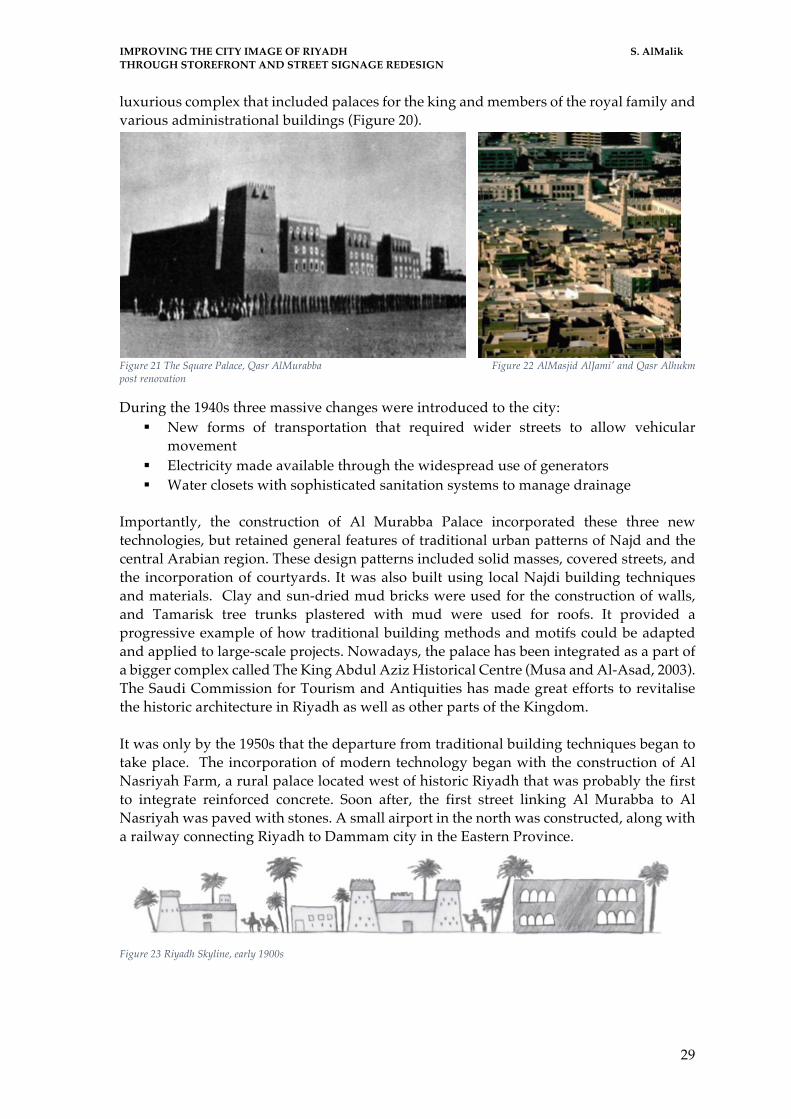
IMPROVING THE CITY IMAGE OF RIYADH S. AlMalik THROUGH STOREFRONT AND STREET SIGNAGE REDESIGN
29
luxurious complex that included palaces for the king and members of the royal family and various administrational buildings (Figure 20).
Figure 21 The Square Palace, Qasr AlMurabba Figure 22 AlMasjid AlJami' and Qasr Alhukm post renovation
During the 1940s three massive changes were introduced to the city: § New forms of transportation that required wider streets to allow vehicular
movement § Electricity made available through the widespread use of generators § Water closets with sophisticated sanitation systems to manage drainage
Importantly, the construction of Al Murabba Palace incorporated these three new technologies, but retained general features of traditional urban patterns of Najd and the central Arabian region. These design patterns included solid masses, covered streets, and the incorporation of courtyards. It was also built using local Najdi building techniques and materials. Clay and sun-dried mud bricks were used for the construction of walls, and Tamarisk tree trunks plastered with mud were used for roofs. It provided a progressive example of how traditional building methods and motifs could be adapted and applied to large-scale projects. Nowadays, the palace has been integrated as a part of a bigger complex called The King Abdul Aziz Historical Centre (Musa and Al-Asad, 2003). The Saudi Commission for Tourism and Antiquities has made great efforts to revitalise the historic architecture in Riyadh as well as other parts of the Kingdom. It was only by the 1950s that the departure from traditional building techniques began to take place. The incorporation of modern technology began with the construction of Al Nasriyah Farm, a rural palace located west of historic Riyadh that was probably the first to integrate reinforced concrete. Soon after, the first street linking Al Murabba to Al Nasriyah was paved with stones. A small airport in the north was constructed, along with a railway connecting Riyadh to Dammam city in the Eastern Province.
Figure 23 Riyadh Skyline, early 1900s

IMPROVING THE CITY IMAGE OF RIYADH S. AlMalik THROUGH STOREFRONT AND STREET SIGNAGE REDESIGN
30
1950-1960
King Saud bin AbdulAziz
When the Royal Prince Saud bin AbdulAziz became King in 1953, he made three decisions that played a major role in further urban expansion. First, he ordered the transfer of most governmental offices from Mecca to Riyadh. Subsequently, various buildings were constructed along the King Abdul Aziz Airport Road. Secondly, the construction of Al Malaz project, that later came to be known as Al Riyadh Al Jadidah (The New Riyadh), added nearly 4.5 kilometers of development to the northeast of the city centre. Al Malaz covers an area of almost 500 hectares and consists of around 750 villas, three apartment buildings, as well as the necessary infrastructure (Figure 12). Living in apartment buildings was a new concept, introduced to Saudis via Al Malaz Project (Musa and Al-Asad, 2003).
Figure 24 AlMalaz Residential & Commercial Expansion Project
Third, the King decided to reconstruct and considerably expand Al Nasriyah into a royal complex that included a number of luxury residences, a group of villas, various residential buildings, as well as other necessary facilities. The three projects had great impact on the architectural and urban development of Riyadh and the Kingdom in general. These projects, particularly Al Malaz, introduced a new way of thinking about urban planning and city construction. Furthermore, the orthogonal grid planning pattern that was adopted in both Al Malaz and the reconstruction of Al Nasriyah was a clear departure from the traditional organic urban pattern of Riyadh. The grid planning pattern in Al Malaz served as a model in the more recent planning projects for Riyadh. Al Nasriyah, on the other hand, was a luxury residence enclosed by walls that created a limit and restrict city growth. Therefore, the walls were unlikely to be incorporated as a planning model for other residential neighbourhoods in the city (Musa and Al-Asad, 2003).

IMPROVING THE CITY IMAGE OF RIYADH S. AlMalik THROUGH STOREFRONT AND STREET SIGNAGE REDESIGN
31
Figure 25 Riyadh city expansion during King Saud's reign
By the late 1950s, apartment buildings started to spread through city districts, the first six and ten-story buildings were constructed overlooking Al Adl Square (Justice Square) and Al Wazir Street (The Minister’s Street).
Figure 26 The 6 and 10 storey apartment buildings of 1959 Figure 27 Zahret AlRiyadh Building
The design of buildings maintained privacy, a very important and prominent element of the Arab culture. The buildings overlooked public areas, but did not permit a view into the interiors of any of the one- or two-story single-family houses nearby. The sides of the buildings that faced neighbouring houses were retained for services and staircases, window openings were limited and located above eye level to avoid invasion of privacy.
By the late 1960s, Zahret Al Riyadh (Riyadh’s Flower) building was under construction, violating many privacy codes for the first time. Large windows and balconies on all four façades made the neighbouring single story residences and their gardens completely visible, creating complaints that were taken to court. Although the residents whose privacy had been compromised won the case, once they moved out of their homes, the results of the case were ignored and new construction designs that deviated from tradition continued. New residents proved not to be as powerful or influential as those who had complained originally. The architecture of this building applied a façade that had not been allowed previously in the country, including balconies and windows around all sides of
IMPROVING THE CITY IMAGE OF RIYADH S. AlMalik THROUGH STOREFRONT AND STREET SIGNAGE REDESIGN
32
the building without the consideration of what these units overlooked. Finally, Zahret Al Riyadh was completed and neighbours were forced to develop new architectural and landscape options to maintain their privacy. This was a significant change in the evolving architectural identity of the city as new designs were needed to find solutions to privacy concerns (Musa and Al-Asad, 2003). The final major achievement during the reign of King Saud, for Riyadh specifically and the Kingdom in general, was paving the roads with asphalt, further modernizing the country and its capital.
1960s and early 1970s
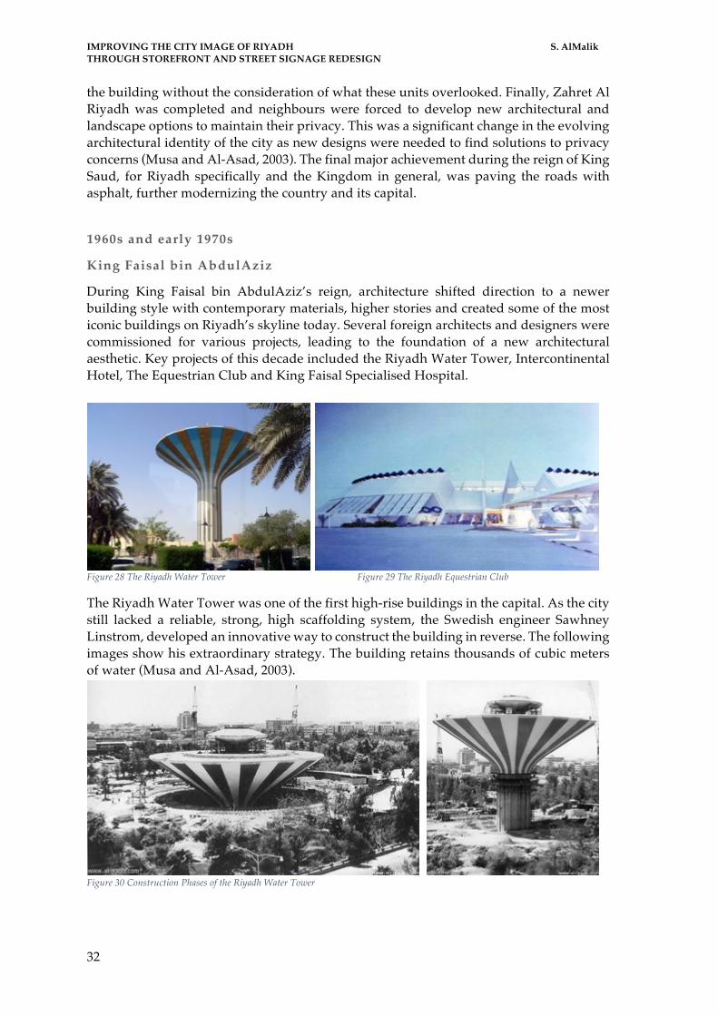
King Faisal bin AbdulAziz
During King Faisal bin AbdulAziz’s reign, architecture shifted direction to a newer building style with contemporary materials, higher stories and created some of the most iconic buildings on Riyadh’s skyline today. Several foreign architects and designers were commissioned for various projects, leading to the foundation of a new architectural aesthetic. Key projects of this decade included the Riyadh Water Tower, Intercontinental Hotel, The Equestrian Club and King Faisal Specialised Hospital.
Figure 28 The Riyadh Water Tower Figure 29 The Riyadh Equestrian Club
The Riyadh Water Tower was one of the first high-rise buildings in the capital. As the city still lacked a reliable, strong, high scaffolding system, the Swedish engineer Sawhney Linstrom, developed an innovative way to construct the building in reverse. The following images show his extraordinary strategy. The building retains thousands of cubic meters of water (Musa and Al-Asad, 2003).
Figure 30 Construction Phases of the Riyadh Water Tower

IMPROVING THE CITY IMAGE OF RIYADH S. AlMalik THROUGH STOREFRONT AND STREET SIGNAGE REDESIGN
33
During that same period of architectural evolution, King Faisal appointed Doxiadis Associates, a Greek firm to prepare relevant studies for the development of a master plan. The proposal was aimed to control city growth and direction until the new millennium. The plan, completed by 1972 included the following characteristics:
§ Following a grid pattern aligned along the north-south and east-west directions § Establishing two perpendicular, central, linear spines to the city
o North-south; to house commercial buildings o East-west; to locate institutional and governmental buildings
§ Extending residential neighbourhoods behind commercial and institutional linear backbones
§ Recognizing cars as the main mean of transportation § Designing streets in a hierarchical pattern including freeways linking the capital
with other regions in the kingdom. It included expressways serve high-speed traffic inside the city, arterial streets that operate heavy-traffic inside the city, collector streets that link the neighbourhoods together, and local streets that run inside the neighbourhoods.
The Doxiadis Master Plan for Riyadh was subsequently upgraded by the French planners SCET- International. However, the main features of the original master plan, primarily the 2 by 2-kilometer grid, were maintained. As Riyadh expanded, it extended eastwards and northwards. Unfortunately, the grid pattern endorsed an undesirable horizontal expansion of Riyadh for various reasons, to name a few; firs, the poor planning in leasing and arrangement of land, second, the enforcement of setting inadequate land-sizes for agricultural purposes to avoid violating developing urban protection zones, third, citizens are required to use automobiles due to the lack of pedestrian pavements and zones, finally, the scattered residential and business areas that are only accessible by cars (Mubarak, 1995)
1970-1980
King Khalid
Newsweek magazine described the city of Riyadh as “the biggest construction site in human history” when writing about the capital’s rapid development during the 1970s and 1980s.The rise in oil prices contributed tremendously to the construction boom, encouraging growth and transforming the city by introducing new architectural treatments. Riyadh was given a makeover with the introduction of reflective glass as curtain walls for the facades of new establishments. Multiple design shifts are evident in Riyadh through the first five decades of the Saudi reign. Its architectural image, urban structure, and overall identity underwent substantial developments in various construction aspects. From typical mud bricks, small twisted pathways, public squares with access to the royal palaces and mosques to high-rise glass buildings covered, paved streets of different widths to accommodate cars, vast residential neighbourhoods spreading out into new districts (Musa and Al-Asad, 2003). The abundant materials and treatments introduced through modernisation kept changing the
Figure 31 The Dioxiadis Master Plan of Riyadh

IMPROVING THE CITY IMAGE OF RIYADH S. AlMalik THROUGH STOREFRONT AND STREET SIGNAGE REDESIGN
34
city’s colours and textures; the skyline witnessed a complete transformation with new heights and shapes and reaching new limits. Simultaneously, cultural necessities challenged architects, particularly foreign architects who had never been to Saudi Arabia or did not understand the culture.
Figure 32 Riyadh Skyline 1930s-1980s
1980-2005
King Fahd
By the mid 1980s, citizens were becoming more aware of architectural trends, and building construction. Several Saudi and Arab architects began playing a major role in the city’s development, inspired by local architectural heritage of old Riyadh. Architectural plans began to blend old patterns and design concepts to new building motifs. King Saud University and King Khalid International Airport are examples of the combination. Moreover, Zuhayr Al Fayiz Consultants is considered one of the pioneer Saudi architects that has participated in the capital’s recent development; the firm designed the Ministry of Municipal & Rural Affairs. The design has been referred to as an oasis in the centre of Riyadh. Among the popular Saudi architectural characteristics of the building, are the massive blocks and small windows resembling desert fortresses, and the interiors lit by skylights and central atriums as well as smaller courtyards around which offices are placed.
Figure 33 Ministry of Rural and Municipal Affairs

IMPROVING THE CITY IMAGE OF RIYADH S. AlMalik THROUGH STOREFRONT AND STREET SIGNAGE REDESIGN
35
During the mid 1980s and as a second phase of the project of the redevelopment of the old city centre, the Jordanian architect Rasem Badran of Dar al-Omran was commissioned to design the buildings for The Great Mosque of Riyadh and Qasr al-Hukm, Badran. The scope of work included the urban development of the adjacent public squares, particularly AlAdl Square, streets and parts of the walls of the old city. The project received several prizes including the 1995 Aga Khan Award for Architecture and the 1990 Arab Architecture Award of the Organisation of Arab Cities. Badran succeeded in recreating the character of the old Islamic city's mosque, not only through incorporating traditional vocabulary associated with Najdi mosque architecture but by incorporating flat roofs, courtyards, arcades, limestone cladding, and slit-type windows surmounted by triangular openings. However, the mosque's renovation and inclusion in the urban fabric of the old city centre protected its function as a place of worship as well as a centre of commercial and communal activities in that part of the city (Musa and Al-Asad, 2003).
Figure 34 Ministry of Foriegn Affairs designed by Henning Larsen Figure 35 Saudi Television Tower
By the year 2000, two major landmarks that impacted the Riyadh skyline were completed. The first was the Al Faisaliah Complex designed by Norman Foster + Partners and the second was the Kingdom Centre, designed by Ellerbe Becket together with Omrania & Associates. Both centres serve numerous functions and house, five star hotels, offices, shopping malls and are distinguished by a central skyscraper. Both buildings depart from a tradition-oriented architectural and urban model to a more global one. Undoubtedly, they will have a vital impact on future building directions in Riyadh as well as in the other cities in Saudi Arabia.
Figure 36 AlFaisaliah Tower and Commercial Centre Figure 37 AlMamlaka Tower and Commercial Centre

IMPROVING THE CITY IMAGE OF RIYADH S. AlMalik THROUGH STOREFRONT AND STREET SIGNAGE REDESIGN
36
Figure 38 Saudi Arabian National Museum
Many important buildings, that affect the skyline till the present day were constructed between the two decades from 1980s to the new millennium. The scaffolding systems were solid and more dependable, new materials in addition to supporting building equipment and machinery were available. Moreover, the rise in numbers of construction workers from different countries and their expertise all became reasons to the architectural boom in King Fahad’s reign. Important buildings of this era include; Different important buildings of this era include;
§ The Television Tower built in 1982 (figure34) § The Institute of public administration by TAC (The Architects Collaborative) § The King Fahd Stadium completed in 1987 designed by the British firm Ian
Fraser, John Roberts and Partners as an international FIFA football field that accommodates 70,000 visitors. The roof construction of the stadium consists of a number of tent-shaped Teflon-coated fiberglass units supported with cables
§ The Ministry of Interior built in 1989 by Archisystems, Musalli, Shakir Mandili § The Diplomatic Quarter, designed by Albert Speer & Partner, the Beeah Group
Consultants, and architect Farhat Tashkandi, currently housing 54 embassies and 40 public buildings, and hundreds of private residences
§ The Saudi Arabian National Museum designed by the Canadian firm Moriyama & Teshima Architects with Büro Happold Engineers
§ King Fahd National Library § The King Saud University Campus designed by HOK and 4 Consortium § The King Khalid International Airport designed by Hellmuth in 1984 completed
in 1999 § The Ministry of Municipal & Rural Affairs designed by Zuhayr Al Fayiz
Consultants § The Ministry of Foreign Affair, by Henning Larsen designed completed in 1984
and which received the 1989 Aga Khan Award for Architecture as well as, a number of other international prizes
§ The Great Mosque of Riyadh and Qasr AlHukm by Dar AlOmran § AlFaisaliah Tower, by Norman Foster + Partners § The Kingdom Tower, designed by Ellerbe Becket and Omrania & Associates

IMPROVING THE CITY IMAGE OF RIYADH S. AlMalik THROUGH STOREFRONT AND STREET SIGNAGE REDESIGN
37
Figure 39 Ministry of Interior Affairs Figure 40 King Khalid International Airport, interior view
Figure 41 King Fahad Stadium
Figure 42 Dimplomatic Quarter of Riyadh
Figure 43 The Great Mosque 1992

IMPROVING THE CITY IMAGE OF RIYADH S. AlMalik THROUGH STOREFRONT AND STREET SIGNAGE REDESIGN
38
2005 – 2015
King Abdullah
The King Fahad National Library was built originally in 1988. It is one of the most important cultural buildings in the Kingdom of Saudi Arabia. In 2013, the library was given an architectural facelift, while preserving the 1988 structure. The recent square building is covered by a filigree textile facade following traditional Middle Eastern architectural patterns. Gerber Architekten designed the urban unit taking advantage of the existing park and incorporating it into the spacious square with the library forming an iconographic urban unit.
Figure 44 King Fahad National Library 1988
Figure 45 King Fahad National Library - Present
Figure 46 King Fahad National Library Architectura Phases Figure 47 King Fahad National Library interior view - Present

IMPROVING THE CITY IMAGE OF RIYADH S. AlMalik THROUGH STOREFRONT AND STREET SIGNAGE REDESIGN
39
The King Abdullah Financial District is one of the latest master projects. A new development under construction that consists of 59 towers in an area of 1.6 million square metres, turning Riyadh into a high-tech oasis of glass, steel and concrete, home to huge office buildings, grand hotels and large hospitals. Additionally, the capital is home to the world’s largest all-female university Princess Nora Bint Abdulrahman University (PNU). The global award winning firm of design and architecture, Perkins+Will, collaborated with Dar Al-Handasa, to design and build the campus concurrently on the dedicated three million square meter site. The university promises to deliver state-of-the-art facilities and education in various academic disciplines. Ascertaining its position as a global leader in 21st century learning.
Figure 48 Render of King Abdulla Financial District (KAFD)
Figure 49 Princess Noura bint Abdulrahman University Campus

IMPROVING THE CITY IMAGE OF RIYADH S. AlMalik THROUGH STOREFRONT AND STREET SIGNAGE REDESIGN
40
The evolution of Riyadh’s skyline;
Figure 50 Skyline of Riyadh - 1930
Figure 51 Riyadh Skyline - 1980
Figure 52 Riyadh Skyline - Present
IMPROVING THE CITY IMAGE OF RIYADH S. AlMalik THROUGH STOREFRONT AND STREET SIGNAGE REDESIGN
41
CHAPTER II LITERATURE REVIEW

IMPROVING THE CITY IMAGE OF RIYADH S. AlMalik THROUGH STOREFRONT AND STREET SIGNAGE REDESIGN
42

IMPROVING THE CITY IMAGE OF RIYADH S. AlMalik THROUGH STOREFRONT AND STREET SIGNAGE REDESIGN
43
LITERATURE REVIEW Urban Decorum The concept of urban decorum began during the renaissance period around the 17th century. During that era, it was referred to as Art Urbain French for urban art. According to Gant and Rubio, (2015), the ornamentation was given a large role in city beautification closer to the end of the 17th century. The relevance of a building’s purpose to its users, the area and other buildings’ surrounding it all were taken into consideration, resulting in the drawing of the city or street as a whole instead of individual blocks. Towards the eighteenth century and early in the nineteenth century as well, ornamentation became a focused element. Art Urbain shifted to the architects of Beaux Arts as an essential way to express themselves and art via architecture. However, once technology and science began to modernize the quality of life, a shift in Art Urbain occurred, and a new name Urbanism was introduced. Urbanism became a new instrument of city organization that redirected its focus towards fundamentals such as; public hygiene, ventilation, fresh air, sunlight, safety and social justice (Remesar, 2015; 2016). Several scientists and meteorologist in Paris, Berlin, Vienna, and London began to study relationships between industrialized sites over long climatic changes and population density (Meller, 2014). Patterns of temperature, precipitation and wind circulation were studied for the mentioned sites incidentally; the climate became a concern of doctors as they realized the public health and hygiene was affected greatly by climate and its changes. Haussmann’s international model, was one attempt, where the revolutionary architectural and urban model changed the way people lived, by giving more importance to the linkage of centres to railway stations over the connection of community and social buildings. In a way, it is similar to how Riyadh nowadays is designed to accommodate cars rather than pedestrians (Hewitt, 2016). In both cases the essence of togetherness and community is destructed, and historical architecture is torn down to build bland architecture and uniform buildings. The ground-breaking studies of Cerdà on how to expand Barcelona accommodated urbanism fundamentals and most importantly prioritized the community and liveability of the city to its inhabitants (McGrath, 2016). In a study done by Remesar and Garcia of Fabian Estapé’s biography of Ildefonso Cerdà, they noted; Cerdà’s plan was built specifically for Barcelona, it directed attention to how the city was, the existing architecture, the state of the people and how it needed to improve. When Haussmann requested the same plan to be used for Paris’s expansion, Cerdà astonished, replied: “No, I cannot sell them, they are not for sale, I designed them for Barcelona and I wrote them for Catalonia”. (Remesar et Garcia Fortes, 2013) Moreover, Remesar elaborated in his article on city aesthetics on the ensuing movement of city organization in urban decorum that occurred towards the end of the nineteenth century, Art Public - Civic Art - Civic Design. Here the major organizational shifts were concerned with social justice and attractiveness for tourists (Remesar, 2015). Cities became much larger; they were not ready urbanely (infrastructural-wise), socially or politically. This movement aimed to improve and beautify the city through firstly, housing. Second, heritage, which refers to monumental and historical buildings, plazas and spaces that cannot be moved or contained (Sommer, 2013). Thirdly, historical artefacts and daily

IMPROVING THE CITY IMAGE OF RIYADH S. AlMalik THROUGH STOREFRONT AND STREET SIGNAGE REDESIGN
44
objects that can be preserved and displayed in museums. In France, Britain, Germany and North America however, the focus was more towards city planning (Wiechmann & Bontje, 2015). During this movement ornamentation was not a main concern of urban decorum, it had expanded over the centuries to include space, health, politics, economy and other elements. Ornamentation towards the twentieth century was seen as an excess. Embellishment and décor meant more time, which lead to less productivity, which would affect the economy, equally as it would labour. A different mentality emerged, to produce more, in less time. This created more jobs, more products, that could be reached to a mass general instead of being exclusive to status. This is where architecture of today began to clash with that of yesterday and previous eras. Historical buildings were a prime location for poverty and illness, the hygiene intervention abilities were limited due the tight space. In contemporary urban policies and projects, plans to terminate such health issues are considered within the logic of strategic planning. This coupled with the concepts of creating touristic cities and with the direct effects of globalization, resulted in a general loss of city images and uniqueness around the world. The images of distinct cities with different cultures are more and more like each other (Urbain, nd). This can be explained by depicting that more and more cities have to follow an extremely homogenising international model imposed by the multinational financiers of the great projects of urban revitalisation. The model basically targets the international tourist rather than the local inhabitant and requires a certain world standard, a standardized urban space. As is already the case with the standardised spaces of large international hotel chains, or airports, fast food chains, shopping malls, theme parks or gated communities which also make major world cities look more and more like each other. The identical urban landscapes are forming a single image or perhaps even as Remesar says; generic. The tourist, unlike the inhabitant does not appropriate the space, he simply passes through it. Thus, the memory of local culture which should at first be preserved is lost, and in its place, is created great scenarios for tourists. In most cases, the local population itself is expelled from the intervention site by the process of gentrification (Remesar, 2015). According to Remesar and Díaz, (2015), in the rich peripheries this does not occur since these areas are already projected within an idea of social segregation and still offer a level of total vigilance, as well as within an international security standard. Which also serves as justification for a broad process of privatisation of public spaces, which has been occurring systematically in most of the expansion areas of contemporary cities. The contemporary process of spectacularisation of cities is inseparable from urban marketing strategies which seek to build a new image for the city that guarantees it a place in the new geopolitics of international networks. What is sold today internationally is, above all, the brand image of the city and the priority for economic reasons. The competition is fierce and the municipalities strive to succeed in selling the branded city image, or logo, marketing and the tourism, through its greater decoy; the spectacle. In the aphorism, Remesar, (2005) instigated that the spectacle is the capital in such degree of accumulation that becomes image. We would have moments that we could call urban spectacularisation: the modernisation of cities, in which one begins to shape modern urban images, then begins to sell them as archetype; more than that, international urban marketing consultancies aim to create new brand images of cities, that use culture as a facade for both real estate speculation and advertising itself politics in times of elections. To mention a few city marketing slogans; Definitely Dubai, Abu Dhabi –And you think you’ve

IMPROVING THE CITY IMAGE OF RIYADH S. AlMalik THROUGH STOREFRONT AND STREET SIGNAGE REDESIGN
45
done it all?, Malaysia truly Asia, Egypt – where it all begins, Switzerland. Get natural., España – I need Spain, Croatia – the Mediterranean as it once was. Urban Cohesion Camps-Calvet, Langemeyer, Calvet-Mir, and Gómez-Baggethun, (2016) notified that the growth and expansion of cities in recent decades has encouraged the segregation of urban cohesion with little social mix. This pattern of predominant urbanisation has negative effects on the urban fabric and leads to the fragmentation of the city. It is clear that the ability of cities to promote integration in a sustainable and equitable way, and to continue to plan for the future, presents both challenges and opportunities. Degen and García, (2012) reinforced that identifying more compact, better connected and integrated urban patterns can help make more policy decisions aimed at improving social cohesion. This strategy implemented in a participatory manner can be used both; in the renovation of existing neighbourhoods and residential complexes, as well as in urban expansions and new city projects. Those excluded from this process of cohesion may carry with them the key to their reversal which would be as Remesar and Ricart suggested; popular participation itself (Ricart & Remesar, 2013). The city of Florence today, would be a prime example of this popular participation since the inhabitants are the true responsible for their effective construction unlike the formal city dwellers who very rarely feel involved in the construction of their urban space and in particular of the public spaces of their city. Similarly, Remesar specified that Roman cities in general perhaps even by their informality still manage to maintain some kind of diversity of multiplicity in the urban space. Even though they are subject to the homogenising wave of the city-spectacle, urban social actors still manage to reverse the process by appropriating public spaces, housing or varied meetings. The so dreamed urban cohesion and integration is a sense of revitalisation that would no longer be the economic but the vitality as life resulting from the presence of public and diversified activities could only be realised in a non-spectacular way when an appropriation occurs in a participative way of public space. Brandão, (2006) explained that the greatest question of interventions would not lie in the requalification of physical space or material but in the type of use that is made of the public space, that is, in the public appropriation of these spaces. Only through an effective participation can the public space cease to be scenery and become a true urban stage: space for exchanges, conflicts and encounters. What, then, are some alternatives to the urban spectacle? Brandão suggests; the participation, the actual experience and the experience of urban spaces. These alternatives would necessarily pass through the very physical experience of the city, which is almost impossible or totally artificial in ‘spectacular cities’, like the example he suggests; Rio de Janeiro. Only the sensory experience, individual or collective would not allow itself to be reduced to mere images. The city would not only cease to be scenery and would be the stage but more than that it would become a body, another body. Brandão, (2002) specified studying the architecture in Lisbon that it is this relationship between the physical body of the citizen (or the architect-urbanist), who evidently cannot but be a citizen and this other urban body that could give rise to another form of apprehension of the city.

IMPROVING THE CITY IMAGE OF RIYADH S. AlMalik THROUGH STOREFRONT AND STREET SIGNAGE REDESIGN
46
Similarly, this approach would yield significant benefits in terms of environmental sustainability and help in the fight against climate change. Various countries and cities have demonstrated that managing spatial patterns and investing in collective solutions can improve urban equity, support social cohesion and unleash a virtuous circle with positive effects on social development, a spatial solution to social problems (Roigé Montornés, 2014). In some regions, for instance, Barcelona, more radical concepts such as spatial justice are discussed. Most of these perspectives emphasize the importance of investing in public space, locating services and benefits to improve proximity, increase connectivity and provide an organized space for urban growth (Speranza, Keisler, & Mai, 2015). Relationship with the Development Agenda Post 2015 and Habitat III The theme of the Dialogue is of great importance for the current debate on the Post 2015 Agenda in Spain13. The issue of solving inequity to ensure a decent life for all is a key element of the debate on the Post 2015 Agenda. As part of the dialogue on the Sustainable Development Goals (ODS), several organizations, including the Sustainable Development Solutions Network, the Global Cities Network, Local and Regional Governments (UCLG), Local Governments for Sustainability (ICLEI), The Alliance of Cities and UN-Habitat, advocate a comprehensive approach to sustainable urban development, in which social, economic, environmental and spatial aspects should be closely interconnected through "Urban ODS" (Graute, 2016). The Dialogue provides the opportunity to explore possible goals and indicators related to social integration in housing and urban development. The Dialogue will also provide a forum for in-depth discussions on how local, regional and national authorities can contribute to a New Urban Agenda, developing better policies, plans and designs for cities that are more compact, socially inclusive and connected, that promotes sustainable urban development and are adaptable to climate change. From this perspective, the dialogue will deepen the concept of social integration through successful spatial expansion strategies. As part of the preparatory substantive reflection on Habitat III, the Dialogue will be an opportunity to explore how lessons learned in successful initiatives can be included in the "International Guidelines on Urban and Territorial Planning", with particular emphasis on the social integration dimension (Acuto & Rayner, 2016). The urban phenomenon can therefore be approached from three main categories; The public space, urban cohesion and urban decorum. Each focusing on a different scale and challenging different components of the public, their space, the architecture and the city. City Image and The Image of a City The development of a city's infrastructure characterises the identifiable features of traditions and contemporary structure as the main source of identity for the residential city. Riyadh city's infrastructure has a strong dynamic due to its geographical location; being situated on a rocky sand plateau, Najd, with many valleys cutting through it, results in expansions from annexed regions costly. However, construction companies in Riyadh are inspired by the aforementioned dynamic, to develop the capital with a modern architectural approach that attempts to benefit from the advantages of location. Hence the
13 Thematic Meeting PUBLIC SPACES 4-5 April 2016; “The Habitat III Urban Dialogues are a series of e-discussions occurring within the
Habitat III preparatory process, with the aim to gather views from interested players to bring forward new and emerging thinking on
urban issues to be considered for inclusion in the New Urban Agenda”

IMPROVING THE CITY IMAGE OF RIYADH S. AlMalik THROUGH STOREFRONT AND STREET SIGNAGE REDESIGN
47
dynamic effects on construction in the last decade. On another note, despite the many denominations that Barcelona receives today, the significant changes in its built space and in the city experience reflects more contemporary social and cultural transformations. The configurative image in Barcelona is that of logistics centre and of advanced services, it inspires an industrial dynamic supporting the processes of reconversion of industry and strengthening of existing production and the creation of other chains. It seeks to reinforce the centralities of neighbourhood, region and municipality renewing quality, by reducing the sectorisation of uses. The product of urbanism, when submitted to the market becomes a competitive obsession. The economic strength of private initiative, and the political weakness of public initiatives are the barriers in making the identity of a place, a concrete reality. Montello, (2014) contemplated how to turn cities from thematic parks, business cities, closed and socially segregated neighbourhoods, vehicles built environments, plazas and monuments into identity. There is a reasonable consensus on the objectives of Urban Design, from those indicated by Kevin Lynch to those indicated in several guides and reference manuals. According to Kevin Lynch (Lynch, 1984), to understand a site in terms of land use, ecology, landscape and ground conditions, social factors, history and archaeology, urban form and transport as well as, to facilitate and manage a participatory process, in addition to planning design principles and programing construction development; it is essential to establish a competent team of various fields integrated into the Urban Design process. Organisation and teamwork amongst the professionals, as well as a practical question of who should coordinate and who has the overall vision, all must be studied depending on the project at hand (Ricart & Remesar, 2013). Kevin Lynch instigated in his book ‘Image of the city’ (Lynch, 1960); the cultural traditions of urban design come from origins; 1) the visual and artistic: It is a tradition consolidated from the design of the city, emphasizing the quality of the buildings and the great tracings, with examples such as Le Nôtre to Camilo Site in a route that will pass through the great modern utopias, New cities of Unwin to the radiant city of Corbusier, without despising the component of urban "image", of Lynch; 2) the social use of space: Focused on the social qualities of human communities and the activities that can induce them coming from ancestors like Cerdá. Lynch, (1972) reflected in his book that raising the imagery of the urban environment is to facilitate its identification and visual structuring, these keys of Urban Design can be summarised in another way, as common themes that run through a whole set referencing certain and general physical characteristics. They are the categories with direct interest for the drawing, since they describe qualities that the designer must operate: 1. Singularity figure-background; 2. Simplicity formal; 3. Continuity; 4. Dominance; 5. Clarity of links; 6. Differentiation of directions; 7. Visual field; 8. Perception of movement; 9. Time series; and 10. Names and meanings. According to Bocchi, Marini, Bertagna, and Santangelo, (2013), postmodernity marks the imagined urban profile of the city. It is discovered fragmented and manifested in our dreams, tastes and consumptions. Public space can be used in an exploratory manner stimulating the knowledge of the city as an idea of a competitive platform to take advantage of better conditions through infrastructure that leads the city to connect with

IMPROVING THE CITY IMAGE OF RIYADH S. AlMalik THROUGH STOREFRONT AND STREET SIGNAGE REDESIGN
48
the country and with the world via telecommunications. Lynch, Banerjee, and Southworth, (1995) instigated that the awareness of the environment and the geo-economic territory as a means of support added value chains, population flows, human settlements and connection with the rest of the country and the world (Roca, Aquilué, & Gomes, 2015). Da Cruz, (2016) instigated that an urban project is linked to the economic aspects of image of prestigious or exceptional metropolitan mega-projects, promoted by the public initiatives. Today, the intervention destined to an urban project arises not from the formal plans and from the local government programs and strategic plans but it arises from where the political decision is interpreted and from where it is subjected to evaluation. The program defines the financial, organisational, marketing, the choice of technical consultants, as well as the consensus feasibility of intervention. The program, therefore, must show its effectiveness, in relation to the objectives and proof of visibility or adequacy of the image in the urban context. The classic work, ‘The Image of the City’ by Kevin Lynch, has reinforced that the alienated city is, first of all, a space that some people are unable to mentally construct in a maps while the urban public space represents their own position in relation to the urban totality - in which they are thus in the traditional city and its misalignment, implying the practical recovery of the sense of orientation, as well as, the construction of an articulated set that can retain the memory and from which each subjected citizen or visitor can individually design personal mental maps. The formal continuity, such as the enlargement grid and the large axes, among others, are important factors of citizen integration on one hand. On the other hand, it is desirable that each zone of the city has differential elements, either as a result of the inherited plot, or by the present production of specific morphologies. It is the public space that pays the bill for urban products. Therefore, despite many positive examples of recent experience, it is necessary to be aware that the public space is constantly a present challenge and that we will never be able to consider that as one we have definitely won (Montello, 2014). It is not a technical question nor is it a discussion of town planners; rather, it is a debate of cultural values: coexistence or solidarity, social justice or inequality, civic equality or anomie and above all a social identity. In Riyadh, the economic data are characteristic of an urban project executed with specific resources; a space (natural and urban ecosystem with endogenous and exogenous relations); a time (fixed date of the event and temporal conditions arising from the financing process and return of the investment). The city of Abu Dhabi is transforming into a model of sustainable urbanisation through the use of buildings programmed at the outset, the infrastructures built for accessibility were designed for an already existing urban demand (railway station, subway, circular and radial, bridge), public spaces and equipment were designed at the city scale and the metropolitan area (industries fair, multipurpose pavilion, urban park). In this regard, the city of Riyadh seems to be reduced to urbanisation among many other frustrating expectations inexorably created and legitimised by political commitments. On the other hand, the intervention area of Barcelona was planned as an urban area for housing; employment and leisure (open air and water). Including a large area outside the exhibition grounds, it included other leisure uses (for example a marina, an urban park), residence (upper and medium standard), work (offices and commerce) and of knowledge (universities). The temptation to leave urban development to free competition and to the

IMPROVING THE CITY IMAGE OF RIYADH S. AlMalik THROUGH STOREFRONT AND STREET SIGNAGE REDESIGN
49
immediate economic values of the market is very dangerous, since the public space is especially profitable in social, cultural and civil terms; but it is also, in a medium term as political, governance, and economic terms, generates attraction and creation of new activities (Takeuchi & Perlin, 2012). The identity tends mainly to the social mixture, makes of its use a citizen right of first order, thus the public space must guarantee in terms of equality the appropriation by different social and cultural groups of gender and of age (Montello, 2014). Public Art Elements City Architecture Jacobs, (2010) instigated that the city architecture is an integrative discipline of different methodological and conceptual approaches, directed to the construction of visual messages, framed within the concept of graphic communication. Urban identity, on the other hand, is an issue that requires a multidisciplinary approach (Valera, 1997) so that its study should touch diverse areas of knowledge. However, in the case of city architecture, its effect as an urban expression and as an actor in the construction of the city's identity has been approached from a limited number of areas, such as city branding and information design. Hence, city architecture presents a vision about the way in which these areas have touched the relations between graphic design and city, with emphasis on the reading of the visual manifestations and the role of the design in the conformation of the urban identity. The nineteenth century has been described as a century of urban modernity. Modernity in in city maps, where grids and lines are wider. Modernity in innovative technology, that allows administrative order to serve citizens through urban infrastructure and equipment (metros and traffic information). Modernity by the novel forms of art. It is the cities disfigured by the industrial revolution that have been the reference standard. The following list illustrates various signboard options typically found amid city architecture;
§ Backlit sign: A backlit sign advertises during day and night time, it is constantly lit, requires a good location is essential to be seen.
§ Electronic signs: Easily programmed to convey messages from the company to the clients, costly, high maintenance.
§ Illuminated signs: Lit only at night, or when needed and not necessarily entirely. Throughout the day, they advertise traditional banners: Suitable for temporary advertisement and information, usually used on construction sites, usually difficult to install individual cut letters: gives a professional look, can be back lit by LED, is typically elevated from building facade to catch the eye and drag attention to the advertised space, difficult to install on uneven surfaces, costly.
§ Pylon signs: Upright sign advertising multiple businesses and offices in a specific building or area at once, competition is high between businesses, therefore efforts to stand out and be eye-catching will be higher, disturbs the pedestrian root.
§ Window lettering & graphics: installed on windows showcase different business services and products, colours may fade with light, blocks sunlight from interiors
Clear direction to the office building & street names Corporate design/ identity; accessible from both sides; readable from a distance. Even when the signage of the city architecture is under the action spectrum of information design, they have been considered separately

IMPROVING THE CITY IMAGE OF RIYADH S. AlMalik THROUGH STOREFRONT AND STREET SIGNAGE REDESIGN
50
because the former has a close link with physical spaces, while the latter applies also in non-physical spaces, such as virtual environments and literary publishing houses. However, it is important to keep in mind that the signage, as an information organising science that uses tools to visualize it, is part of the design of information and, therefore, nourishes its methods and tools. Jacobs, (1993) instigated that although systems of orientation through signs and signals go back to the beginnings of civilisation, in recent years discipline has acquired scientific value and has become an important part of information design. The denomination created by architects of the information welcomes to the designers of signage as they are dedicated to grant a sense of order where it does not seem to have some. Furthermore, it helps people find their own way towards knowledge through help in navigation within the spaces of social life. Signage requires a detailed study of many aspects, including the physical (architectural, urban or geographical) structure of the site to be signalled, the role of space (public, private, recreational, social, etc.) and the number of people who will use it. When it comes to cities, however, the issue becomes more interesting because many other factors must be considered; including the interference that the signal will receive from the other street signs, vandalism and the change of political authority that will be carried out periodically, among others. Urban planning and the way in which the city has been born and grown will largely define its sign systems and the extent to which they will be functional (Águas, 2012). Aspects of the Ajuntament’s Effort to Improve Signboards in Barcelona It can be said that the city of Barcelona born as an instrument for the accessibility relinquish contiguity to ensure better convenience among its citizens. Further, Baró, et al. (2016) reciprocated that in the city of Barcelona new free spaces, encompassing, interstitial or peripherals were born and worked for the consumption of their population. They are the old large municipal parks with general policy of urban design and garden architecture; hence these are often abandoned sites, buildings in large railway infrastructures that reduce space, identically in port applications. Maremágnum of Barcelona is everything that, before being transformed, was called Terrain vague according terminology UIA Congress in Barcelona, 1996 (Constant, 2012). In this regard, the citizen no longer uses the magnificent urban parks for the enjoyment of leisure and for what have called consumption of landscape but looking beyond the boundaries of the sprawling city, the landscapes are more rewarding, whether for sport, for simple tourism or for aesthetic contemplation (Williams, et al. 2014). Three main causes, all very certain, have converged to make the value of landscape a beautiful scenery for Barcelona a reality 1) by focusing on the traditional city, often oppressively uncomfortable and still aggressive 2) the drawbacks of easy mobility, which reduces distances until recently only with discomfort 3) and the increasing demands for the rise of economic and cultural levels progressively extending the need for space for natural leisure. According to Borja, Castells, Belil, & Benner (1997), the natural use of the landscape responds to the urban perspective of controlling the conservation and development of certain aspects that could affect their visual and aesthetic perception. Therefore, the technique of administrative intervention is none other than the license to traditional urban planning subjected to a term in the case of the advertising license as subspecies of it. One

IMPROVING THE CITY IMAGE OF RIYADH S. AlMalik THROUGH STOREFRONT AND STREET SIGNAGE REDESIGN
51
of the essential aspects of landscape is the availability of a public space and its avatars in modernity. Public space is a legal concept for a space subject to a specific regulation by the public administration, the owner of the domain guarantees accessibility to all and sets the conditions of use and installation of activities. The modern public space results from the formal (legal) separation between urban private property and public property, which normally means reserving this land free of construction (except collective facilities, mobility infrastructures, cultural and sometimes commercial activities, monumental symbolic references, etc.). Borja et al. (1997) identified that the public space is a place of relationship and identification, of contact between people, of urban animation, and sometimes of community expression. In the traditional historical city, urban memory is fairly easy to define. It is the image that allows citizens to identify with their past and present as a cultural, political and social entity. Consequently, the entire city, the inherited city, composes the whole historic city (Di Masso, 2012). The own dynamics of the city and people's behaviour can create public spaces that are not legally legal, or that were not intended as such, open or closed, passing or to those who have to go explicitly. It may be a factory or an abandoned warehouse or an interstitial space between buildings. They are almost always the access to stations and intermodal points of transport and sometimes reserves of soil for a public work or ecological protection. In all these cases, what defines the nature of public space are its uses and not legal status. The predominant functionalism in modern urbanism soon disqualified public space by assigning specific uses to it. In some cases, it was confused with the road, in others it was submitted to the needs of public order. In fortunate cases, monumentality, urban beautification was prioritised or it was linked to commercial activity (Gutiérrez, 2013). In less fortunate cases however, it was used as a mechanism of social segregation, either to exclude or to concentrate. Sometimes bureaucratic legal procedures led to consider that the ideal public space is the one that is practically empty, where nothing can be done (Juris, 2012). Or that it is protected so much that it is not used by anyone for example, when the best intentions are pedestrianised all access, banning all kinds of commercial activities or services. Sentimental Values of Art in Public Space Memorial sites make it possible to keep past events alive in the common memory through physical presentation in public areas. The experience of the same landscape at the same time will be perceived differently by different people. Also, the experience of the same site at different times will be perceived differently by the same people. The same people could hold a different and conflicting feeling towards a site at any given moment (Bender, 2006). Therefore, when designing the landscape the feeling and the situation related to the landscape must be considered in order to strengthen the social memory. This will help visitors realize the purpose of the space such as mourning, a lesson of historical importance, teaching and reminding young generation of the past events, improving the dialogue between past and present. By achieving this, the design will have a clear strategy on forming the content and the message of the design (Brett et al.,2007).

IMPROVING THE CITY IMAGE OF RIYADH S. AlMalik THROUGH STOREFRONT AND STREET SIGNAGE REDESIGN
52
Place attachment contributes to the making of place identity. Representing memories in a way which can be integrated into cities will remind people of their social history, without visiting a place, also provides a correlation and helps to develop an empathy with citizens and strengthen urban memory. By building landscapes, ever living spaces will be created and effecting positively on urban identity. Integrating memorials as a form of the transfer a cultural knowledge to our daily lives strengthen urban memory. It provides opportunities for citizens and visitors to compare their past and today. For this reason in designing memorial sites landscapes, designers should not only regard giving information to the visitor, but also creating new places with new ways of providing a relationship with the information (Vidal et al, 2010) The use of Advertisement in enhancing the Image of the City Advertising is a polyhedral phenomenon; its intersection with the city accentuates the multiform character. Therefore, the reflection on the relationship between advertising and the city inexcusably passes through the adoption of a multidisciplinary approach with which to explore different aspects of this relationship (Salesses et al, 2013). With this intention in this work are collected the contributions of various authors such as Acebillo, Busquets, Muñoz who approach the subject from different perspectives, the result of different academic backgrounds and lines of research but united by the interest in the advertising phenomenon. The use of advertisement materials deepen not only in the city as a space for information and communication, but also in the multicultural and intercultural character of cities. During the first decades of the twentieth century advertisement throughout Barcelona was impossible to visualise without the ubiquity of advertising that transcends it. Allegation of the need for advertising in today's cities deals with the legal regulation of urban advertising and its relationship with the concepts of order and aesthetic as a counterweight to the aforementioned omnipresence of advertising. Similarly, James, (2012) explains how advertising in cities has been transformed in recent years due to issues such as the diversification of media, the social evolution of the role traditionally played by outdoor advertising or the incorporation of technological innovations. Precisely in this last point, the use of new technologies, illustrates that the image of a city is not only the result of a historical process, but also of planned actions, architectural development, and advertising. In the city of Barcelona, the buildings located mainly in transit areas are the support of advertisements promoting products belonging to various economic sectors. According to Degen, Melhuish, and Rose, (2015), the public roads have become a means of social communication; this has led to urban advertising offer to produce an acceleration of visual saturation, exacerbated by marketing strategies and advertising spaces and circuits. Some of the modalities used in Barcelona as well as other comparable cities are the following:
§ Posting posters, tarpaulins, or luminous signs: A form of advertising that, on many occasions attract attention for its great creative value.
§ Advertising painted on the facades of buildings. The brands paint with bright yellows, blacks and red colours houses of the Barcelonan community.

IMPROVING THE CITY IMAGE OF RIYADH S. AlMalik THROUGH STOREFRONT AND STREET SIGNAGE REDESIGN
53
Figure 53 Graffiti limited to shutter doors and storefronts for advertisment during closing hours
§ Mural of tiles: One modality which has survived in certain urban areas of the present city designs. It is imperative to realise that some of these advertisements still linger on urban facades, commercial establishments especially grocery stores, dairies and small neighbourhood shops, some street furnishings, public benches, or the platforms of the railway and subway stations. The mosaics crossed the urban limits and are located along the outskirts of the city and on the main Barcelonan pavements (Esparaza, 2014)
§ Integrating screens with LED technology of last generation on the facades of buildings. As Urbano, (2016) reciprocated that plasma, LED (Light Emitting Diode), interactive displays multi-touch computing and multimedia systems are being used in the New York by the major players in the advertising campaigns. Architectural structures in London have been designed in enormous dimensions with the product or slogan of the mark on the buildings. Moreover, in London, it is used to advertise products through three-dimensional projections in historical geographical areas
Moghaddam, Assadollahzadeh, Mirmoini, and Azimi, (2013) explained that architecture indiscriminately used as an advertising medium, constitutes values of the architecture itself, and therefore the affirmation of other securities contrary to the fields of cultural heritage, its conservation and favouring social phenomena such as ideological and cultural domination, identity or maximum individual benefit regardless of the means. Although, according to Gutiérrez, (2013), not always this denial of architecture and its value is produced, since many times advertising is integrated into the architecture without causing any aggression, respecting the integrity of the architectural object can be the case that containers of advertising messages become architectural elements, or the same architectural object and can also happen that a set of advertisements are structured architecturally parallel using their own language. Functions of Identity Public space thus includes public domain, collective social use and multi-functionality. It is physically characterized by its accessibility, which makes it a central factor. The quality of the public space can be evaluated, above all, by the intensity and quality of the social relations it facilitates, by its mix of groups and behaviours for its ability to stimulate symbolic identification, expression and cultural integration. Therefore, it is desirable that the public space has some formal qualities such as continuity in the urban space, the

IMPROVING THE CITY IMAGE OF RIYADH S. AlMalik THROUGH STOREFRONT AND STREET SIGNAGE REDESIGN
54
generosity of its forms, its design and materials in addition to its adaptability to various uses over time (Valera, 2013). According to Lynch, environmental perception can be analysed according to three components: structure, identity and meaning. The identification of an object implies in its distinction from other things, its recognition as a separate entity, that is, its identity. Additionally, the city image should include the spatial pattern or the relation of the object to the observer and to the other objects, which Lynch called structure. Analysis of Barcelona, as a Place of Reference The city of Barcelona, an aesthetic place of urban green spaces, as well as the biodiversity it contains, constitutes an opportunity to live the nature within the big city. There are spaces that fulfil environmental and social functions of relationship between people, of play and of walk that are basic for the quality of life and personal well-being. The Barcelona’s green and biodiversity is an instrument that defines the challenges, objectives and commitments of the city council regarding the conservation of green and biological diversity. In Barcelona, biodiversity is integrated into the urban system in the same way as constructed elements (buildings, streets, etc.), and green spaces host a very important component of biodiversity that often goes unnoticed. The ecological infrastructure is the support system for life and has a very important mission to facilitate the functioning of the city, as do other infrastructures (Grimaldi & Fernandez, 2016). The network of spaces with natural, agricultural or garden vegetation, public or private, offers ecological, environmental, social and even economic services. This contribution is strengthened by the continuity of green spaces, which allows the mobility of organisms in a way that does not interrupt the ecological processes (Bakıcı, Almirall, & Wareham, 2013). It seems, however, that such a conflict may have had as its foundation in opposition between different types of value in relation to the river relation of collective appropriation, from the public space, or its private appropriation, by the commercialized spaces. Barcelona is a city where nature and cities interact and be strengthened through the connectivity of the green; in other words: a city in which the urban ecological infrastructure is connected to the peripheral territory and provide more environmental and social services, a city in which biodiversity is appreciated as the collective heritage and, ultimately, a city in which takes advantage of all the opportunities to introduce nature with the conviction that a greener city is a healthier city (Grimaldi & Fernandez, 2016). Thus, the infrastructural planning in the city establishes the strategic lines to develop the heritage as an integral system, but also proposes a model of a city in which green is incorporated as basic ecological infrastructure (Bakıcı et al., 2013). All this is concretised in two key concepts: the connectivity of green and the re-naturalisation of the city. The instrument for working connectivity are green corridors, which are defined, within the urban fabric, as fringes with dominant presence of vegetation, designed for the priority or exclusive use of pedestrians and bicycles. These axes must guarantee the connection between the different spots of green of the city through natural structures, dense vegetation and soft and permeable pavements. This network strengthens the ecological infrastructure and provides functionality to the overall dynamics of the city and its dwellers (Bakıcı et al., 2013).

IMPROVING THE CITY IMAGE OF RIYADH S. AlMalik THROUGH STOREFRONT AND STREET SIGNAGE REDESIGN
55
Barcelona, a Display of Symbolism Barcelona being a symbol in the modern day infrastructure and design, considers the public space not only as an indicator of urban quality but also as a privileged instrument of urban policy to make the city and to qualify the peripheries, to maintain and renew the old centres and produce new centralities, to suture urban fabrics and to give a citizen value to the infrastructures. Barcelona is "the model" on which the economist and many other experts, publicists, politicians, are based, to attribute the rebirth of the city to the politics of public spaces (Zygiaris, 2013). However, it is essential to note that the priority given to public space was rather the result of the lack of resources to carry out major infrastructure rather than an ambitious housing operation. Hence, the architectural alignment used in Barcelona can be used as an example to construct Riyadh on emphasising how urban public space today renews and qualifies European cities. Probably Barcelona is a successful case and more finished than many others, but it is not the only one (March & Ribera-Fumaz, 2014). In Catalonia, Spain, Europe, North America and the South, we find many recent examples of the past 20 years that have been positive. But also, everywhere we find negative cases. New typologies of public space would be at least naive to suppose that the problem of making a city is today resolved, even in the intellectual sphere. The Jaussely Plan, which was enthusiastically conveyed to ensure the solidity in certain spaces that, looked for a greater capacity of urban representation without putting in danger the main lines of the city. According to the Jaussely Plan, the public spaces are reconsidered from different spheres both public and private which in the past did not take into account the commercial areas that reproduce streets and squares and which are no longer closed and exclusive spaces; stations and hospitals that are also multifunctional equipment; university and cultural facilities that have left behind the conception of separate campuses and palaces, creating spaces of transition with the environment (Fraga & Medina, 2016). Although the examples are numerous, in the field of theoretical and intellectual discourse the negative utopias on the city and also in the urban development are manifested constantly negative effects of new polarising and privatising dynamics (March & Ribera-Fumaz, 2014). Territorial Marks and their Significance The infrastructure of a city depends on the territorial boundaries, entry and exit routes and the roads, boundaries of a corners and extremities around the place. March, (2015) identified that the good urban heritage conservation practices can inspire inclusive and holistic approaches to urban development and lay the foundations of tools appropriate for the purposes of planning and legal frameworks. Thus, the development of territorial markings is essential to offer dense urban areas, with mixed functions and quality spaces where innovative urban approaches for the purpose of conservation and the improvement of the quality of life. Hence, the use of local building materials and construction techniques adapted to the climatic conditions can also inspire contemporary architectural models aimed at addressing climate change and the reduction of energy consumption. At the broader territorial scale, historical zones can serve as models of mixed urban development and the density of planning and design of extensions of the city that meet the requirements of compactness, connectivity and integration (Zygiaris, 2013).

IMPROVING THE CITY IMAGE OF RIYADH S. AlMalik THROUGH STOREFRONT AND STREET SIGNAGE REDESIGN
56
The internal structuring of cities obeys, as a priority, the logic of locating the highest income layers. These seek to locate in areas with good accessibility to the main centre and, in doing so, make the accessibility of other areas worse. With the progressive shift of urban services and equipment towards the higher income areas, the location of other classes is progressively (relatively) worse (March & Ribera-Fumaz, 2014). Thus, initially the location of the elites tends to be an area close to the centre. As the urban system develops, a series of services and trades tends to move from the main centre towards the area occupied by the higher classes. Sub-centers specializing in services for these classes then emerge (Garcia-López, 2012). In addition, public investments also tend to focus on these areas, especially those related to the improvement of the road system and, therefore, the accessibility conditions (of the car, not necessarily of collective transport). The same thing happens regarding public services and administrative buildings. In this sense, therefore, it is more feasible for the elites to maintain a structure similar to the figure of the left than to the one of the right. In this way, it is possible to control public investments in a relatively small area, which would not be the case if these areas were scattered throughout the city. The creation of a small set of arterial roads is enough to serve it (Alonso & Ledesma, 2015). Likewise, the creation of many small service centres for elites, for instance, delicatessens, antique shops, restaurants and luxury hotels in various parts of the city would not be feasible. These benefit from the proximity between them to be able to maintain a whole set of urbanistic blessings that could not otherwise be maintained. An opposition between the centre and the periphery allows an increasingly sharp separation between the areas occupied by the housing of the most popular classes and those occupied by the most privileged classes (Ashraf, Glaeser, & Ponzetto, 2016). Thus, a separation between urban functions, which are contained in areas intended for specific functions like commercial, industrial, residential can be effectively demarcated and subsequently become a significant factor to beautify the territorial makings of the city (March & Ribera-Fumaz, 2014).

IMPROVING THE CITY IMAGE OF RIYADH S. AlMalik THROUGH STOREFRONT AND STREET SIGNAGE REDESIGN
57
CHAPTER III ANALYSIS

IMPROVING THE CITY IMAGE OF RIYADH S. AlMalik THROUGH STOREFRONT AND STREET SIGNAGE REDESIGN
58

IMPROVING THE CITY IMAGE OF RIYADH S. AlMalik THROUGH STOREFRONT AND STREET SIGNAGE REDESIGN
59
Summary of Proposed Project
This chapter aims to analyse the data and information retrieved from the participants in order to demonstrate the percentage of civilians’ awareness regarding Riyadh’s city image, its artistic, architectural, and navigational elements. It proceeds to investigate the projects completed by the Arriyadh Development Authority in Riyadh and the Department of Economic Development of Abu Dhabi in Abu Dhabi, capital of the United Arab Emirates, to result in a suitable proposal for improving the city image of Riyadh through storefront and signage Questionnaire In this questionnaire, twenty-two questions were distributed online in both Arabic and English to reach to the maximum number of civilians possible. The questionnaire circulated via various social media platforms which helped in having it reach inhabitants of different age groups, social statuses, educational backgrounds and nationalities, giving a more accurate estimation of the people’s judgement and opinion. The use of social media also helped in achieving the high response rate for the study in a short period of time. The questionnaire has not been validated statistically, but can be considered an initial approach to the opinion of the citizens about the characteristics of the public space of Riyadh. In this way, a focus on comparing several concepts of ArRiyadh Development Authority in Riyadh while obtaining indications on the social perception of the public space. Thus, the questionnaire was completed by 904 participants over the course of two weeks, the answers were collected by the supporting website, survey monkey. The questions were composed to help residents identify elements of art and to provide more accurate answers when asked about artistic features throughout the city. The questionnaire began first, by enquiring if the participant was a local, a frequent visitor, or a foreigner to show that the information obtained is applicable and useful for the study of the local view.
Next, two general questions regarding the overall beauty and organization of the city were posed. The response to question number 2 resulted in almost half the population agreeing the city is considered beautiful to them personally. Answers: 1. Yes, which 48% agreed to. 2. Neutral, which was the answer of 24% of the audience and finally 3. No, which a mere 28% selection. In response to question number three however, the participants confessed they found a lack of organization in the city with 49% of the responses answering “No” to the question: Do you consider Riyadh to be a well organised city. These results are of particular importance to this research as they indicate that 48% agree that Riyadh is indeed a beautiful city although the same percentage declared it is not well organized.
89%
7% 4%
1. Do you live in Riyadh?
Yes
I visit often
No

IMPROVING THE CITY IMAGE OF RIYADH S. AlMalik THROUGH STOREFRONT AND STREET SIGNAGE REDESIGN
60
To follow, question number four revealed the percentage of locals that drive cars —unquestionably men given the fact that women in Saudi Arabia for cultural and traditional reasons do not drive14. The 56% that use private cars are chauffeur driven and this typically signifies they are either women or children (younger than 18 years of age).
Question number five sought to show whether or not the citizens felt the city offered a unique image or identity, the chart below shows the opinion
Subsequently, the questions were specified more oriented towards advertisement, signage, traffic signals, question number six and seven were answered as shown in the graphs.
14 Women is Saudi Arabia do not drive because they are not accustomed to, they are typically provided with chauffeurs, or driven by
male family members. The topic has been addressed many times amongst councils as well as to the king. The deputy royal prince claimed,
the Saudi population needs time and is not ready or equipped for women to drive, which majority of the population declared. "Women
driving is not a religious issue as much as it is an issue that relates to the community itself that either accepts it or refuses it" - Prince
Mohammed bin Salman.
48%
24%
28%
2. Do you consider Riyadh to be a beautiful city?
Yes
No
Neutral
25%
49%
26%
3. Do you consider Riyadh to be a well organised city?
Yes
No
Neutral
1% 1% 4%
53% 56% 4. Which of the following do you use to commute around Riyadh?
Walking
Bicycle
Public transportation
Car - I drive
Car - Chauffeur services
15%
53%
32%
5. Do you believe Riyadh has a unique architectural and/or artistic identity?
Yes, the architecture is unique and original
No, the architecture is repetitive and unoriginal
Neutral

IMPROVING THE CITY IMAGE OF RIYADH S. AlMalik THROUGH STOREFRONT AND STREET SIGNAGE REDESIGN
61
Additional questions (eight, nine and ten) inquired about the methods locals use to commute, navigate, and find addresses. Together with focused legibility of street names and building numbers it becomes clear to see the heavy reliance on GPS. In recent years, the street numbering and signage enforcement has been an area of serious concern for ArRiyadh Development Authority. A new postal system was implemented, improving the clarity of building numbers. In some cases however, one building would have two or more numbers depending on the number of streets it occupied - a corner or a block – Despite the efforts of the ADA, the pace of development in the city has outstripped the rate at which signposts are placed on roads, streets, houses, buildings and other infrastructure. In the answers to question eight, 51% of the respondents indicated that the signage is labelled clearly and are easy to see and follow; however, in this respect, it is vital to say that the citizens of the city can easily see the signs and directions but the disorderly organisation of the city framework leads to confusion and causes many to lose their way. According to Ashraf et al., (2016), buildings registered as historic or natural monuments, or those in the heart of a regional nature park, need illuminated signage to help people’s orientation and reference (Asraf et al.,2016).
16%
17%
67%
6. Do you feel affected at home or in the office by the city lights and street
advertisements?
Yes, I am bothered by them
Yes, I enjoy them
No, I am not affected
22%
47%
31%
7. Do you notice art on the streets, in plazas, on buildings of Riyadh?
Yes, I do
No, I do not
Neutral
22%
59%
19%
8. How do you find shops and stores in Riyadh?
Easily, the names of establishments are written clearly (good font, design, size, colors)
I use gps (maps, google maps, others)
With difficulty, the signage is unclear (clashing designs in one space, confusing, insufficient lighting, etc.)

IMPROVING THE CITY IMAGE OF RIYADH S. AlMalik THROUGH STOREFRONT AND STREET SIGNAGE REDESIGN
62
To follow, question number eleven, tested the degree of annoyance caused by lights, noise, and visual pollution from signage and storefronts. 39% of respondents replied that they consider the present signage design of the city polluting the landscape. Furthermore, the city seems congested and overcrowded with so much signage at roadsides, in public spaces and on territorial landmarks. This is due to the fact that the commercial signage is placed on the facades of buildings, the walls of the vacant lots, on terraces as well as, lampposts. In short, no open space is respected or left commercial-free. Hence, the citizen becomes a captive audience, forced to perceive this collage of directions and excessive information that visually pollutes the city as they travel throughout the city.
The following questions show the level of awareness among the citizens of Riyadh regarding urban municipal positions and responsibilities, as well as their judgment regarding public art elements and their effects on the public and their space. Question thirteen provided sample photos of different art types found in public spaces to clarify the exact inquiry of the question.
51%
29%
20%
9. Do you find it easy to read the street names, exit numbers and traffic signage in
Riyadh?
Yes, they are labeled clearly and are easy to see
I use gps
No, it is difficult, information is unclear and hard to find
32%
44%
24%
10. Do you find that street signage and numbering is up to date with the
development and changes happening in Riyadh?
Yes
No
Neutral
39%
37%
24%
11. Do you believe storefront signage and publicity is visually polluting Riyadh?
YesNoNeutral
17%
14%
57%
12%
12. Who do you think is responsible for city decor?
Architects, engineers
Urban Designers
Riyadh Municipality
I do not know

IMPROVING THE CITY IMAGE OF RIYADH S. AlMalik THROUGH STOREFRONT AND STREET SIGNAGE REDESIGN
63
According to question thirteen, 70% of the sample responded that public art positively affects the people of the city. Around 73% agreed public art reflects the city’s image and culture, whereas 75% believe public art gives the city a character. In question fourteen however, respondents indicated that the problem of outdoor advertising is much more than a mere signpost issue, rather it has a strong impact on the psychology of citizens, in addition to the look of the city. The presence of advertisements, spectacularly imposes an illuminative character that persuades and subtly alters the perception of the urban image of Riyadh. This visual imposition satisfies isolated needs of advertisers that do not consider how contributes to the overall city design. Therefore, on the roads of Riyadh, drivers as well as passengers find it difficult to find their way, given the remarkable proximity of advertising signage. one to one another. The city does lack artistic features; Riyadh’s citizens would like to see more art on the streets in the form of sculptures, murals, fountains, and so on. A sense of pride and loyalty is cultivated among the citizens as a result of what their city offers artistically. As mentioned in the graph above, 40% of citizens agreed that one of the effects of public art is creating a sense of belonging. People enjoy talking about their culture; they take pride in being reminded of historical moments and seeing symbolic monuments— they enjoy sharing these things that the city offers with visitors (ArRiyadh Development Authority, 2016). Responses showed that 70% of the participants think that advertisements in the city are resources representing art and information. Baró et al., (2016) formulated that humans as a social beings have the need to communicate, to be guided to their destinations and thus the importance of the signal emerged. In fact, over the years, this activity has developed to become a mechanism of social communication. Nowadays, in Riyadh the signage is a necessary instrument in the society, to guide and maintain social order. Despite their functionality, the storeowners of Riyadh look for innovative ways for signage to effectively communicate and strengthen the identity of their shop.
70% 73% 75%
40%
1% 1% 1% 2%
13. In what way does public art (sculptures, murals and monuments) affect people and space?
Has a positive effect on people
Reflects the city's image and culture
Gives the city character
Gives a sense of belonging to its citizens
Has no effect
Pollutes the city
Is a waste of space
Has a negative effect on people
26%
26% 17%
15%
16%
14. Which of the following do you consider advertisements on the streets of a city?
InformativeArtisticDistractingOverwhelmingNeutral

IMPROVING THE CITY IMAGE OF RIYADH S. AlMalik THROUGH STOREFRONT AND STREET SIGNAGE REDESIGN
64
The answer to question fifteen, “I did not know I could do anything,” confirms a serious lack in citizen awareness that they are responsible to contact and file complaints upon finding malfunctioning elements on the street. Especially if said elements are essential to traffic flow and the safety of civilians, drivers, passengers and or pedestrians. Furthermore, 28% emphasized their certainty that no one is there to listen to their complaints or queries. The ArRiyadh Development Authority has been reorganised as an official resource that can reach out to people in cases of outdoor advertising on behalf of the State. Henceforth, consideration is being given to the creation of an agency that people can contact, lodge their complaints, report non-compliance and thus add value to the existing developmental structure of Riyadh. The next questions enquired about personal data regarding how residents spend their time, where they travel to (more than one answer was accepted for these questions), to show the global culture majority of Saudis are exposed to. To follow, question 18 poses the same issue only while the participant travels abroad.
6% 2%
40%
24% 28%
15. When you see malfunctioning signage, burnt lights, misplaced/ broken elements on the street, what do you do?
Act immediately, call the police or department in charge
Ask family or staff to take action
I did not know I could do anything
Do nothing, it is none of my concern
Do nothing, no one will listen to my complaint
28%
58% 65%
16% 24%
16. Which do you consider when in search for entertainment?
Going to public places, parks (outdoors)
Going to shopping centres, restaurants (indoors)
Visiting friends and family
Attending public events/exhibitions in the city (shows, plays, competition, etc.)Attending private events/exhibitions in the city (galleries, shows, bazaars, etc.)
28%
45%
73%
41%
3% 6% 4%
30%
17. Which regions do you travel to?
Far East Asia
The Arab world
Europe
North America
South America
Africa
Australia

IMPROVING THE CITY IMAGE OF RIYADH S. AlMalik THROUGH STOREFRONT AND STREET SIGNAGE REDESIGN
65
When participants were asked about the regions they usually visit or have visited, 73% replied Europe. This answer can be the result of a stereotype that architecture and city images are the best in European countries. According to Bocchi et al., (2013), the need to establish a competitive profile of the city becomes evident through images that serve as to attract visitors and create a historical image that protects the tourist from globalising tendencies. Hence, the respondents’ perception of the quality of European life and the preservation of the environment undoubtedly becomes something that must be evaluated. Subsequently, questions nineteen and twenty, further prove the awareness Riyadh locals have developed through their travels.
Finally, questions twenty-one and twenty-two depicted interesting responses. Question twenty-one, Name 3 cities you consider beautiful and well organised. Dubai, was listed in first place, chosen among 189 participants. The fact that the most visited region was Europe, but the city with the highest rating for beauty and organization was in the GCC, suggests an additional series of questions—could the proximity to Saudi Arabia be influential? Nonetheless, London was chosen 141 times and Paris 106. It is imperative to note that Dubai has been a city with the most planned urban landscape. In similar terms, London and Paris have been cities where public places and signage systems are carefully placed and where a foreigner is unlikely to get lost while travelling due to misdirection. Question twenty-two concludes the survey: Name 3 cities you consider unorganised, and visually polluted. This generated the following data; 68 respondents voted Cairo as the most unorganised city followed by Jeddah with 59 replies and finally Riyadh with 32. The fact that over-crowded city dynamics may result in citizens feeling like they are constantly lost, with no evidence of planning of to define city architecture can also be the main reasons participants voted these cities as worst in organisation. Surprisingly, Amsterdam was voted by 32 of the participants to be a chaotic city with no appeal of city image or design.
28%
66%
6%
18. When traveling, do you find it easy to understand the streets and know where you are going?
Yes, the street names and number system is clear
I use gps
No, I find it difficult, I can not find my way
79%
11% 10%
19. When traveling, do you notice public art?
Yes
No
Neutral71%
15%
14%
20. Do you notice differences between Riyadh and other cities, storefronts, billboards and
other forms of advertisement when traveling?
Yes
No
Neutral

IMPROVING THE CITY IMAGE OF RIYADH S. AlMalik THROUGH STOREFRONT AND STREET SIGNAGE REDESIGN
66
Analysis of DED’s Effort to Improve Signboards in Abu Dhabi Abu Dhabi is the capital city of the United Arab Emirates, it is similar to Riyadh in many ways; both cities hold political importance within the Gulf region and the world. They have been on a comparable steady pace of urban development and change. The capitals are considerably quiet cities, peaceful with large roads, palm tree lined streets and limited locations for high-rise buildings within the city. Unlike the successfully marketed city of Dubai, which is known for its busy action filled days, nightlife, shopping festivals, and party scene. Dubai underwent a sudden and rapid urban advancement, it became a business hub, and consequently an air traffic hub, connecting businessmen and women from the east and western parts of the world. It is now very well established with potential overseas investments in real estate and business, whereas Abu Dhabi has managed to attract more long-term investment plans. Abu Dhabi as well as Riyadh are considered cities with diverse potentials for their significant room for growth (Jilani, 2011). It is essential to note that the Abu Dhabi Business Centre of the Department of Economic Development has been working to instil deadlines for the business owners in different localities to alter their signage designs and mark-up in accordance with the stipulation of Abu Dhabi Urban Planning Council. This means that an institution with public access directly outside the commercial centre can install an attached sign provided it complies with the designated rules and regulations imposed by the Abu Dhabi Urban Planning Council. Due to the efforts of the Abu Dhabi municipality in regard to signage, when a property occupies a corner plot or when an institution occupies the corner of an adjacent building at the corner of two streets, an additional sign is allowed on the secondary wall provided it meets the following provisions: 1) the area of the sign is attached to 0.2 square meters per linear meter wall of the establishment where the sign is located, and 2) the area of the sign cannot exceed 50 percent of the sign installed on the front wall (DED, 2012). Furthermore, the governmental efforts in improving architecture of Abu Dhabi and the external appearance of the city has been executed by reorganizing the kinds of advertising signage to reflect a civilised image of Abu Dhabi in accordance with international standards. It is evident that these conditions do not apply to signs from a municipal, provincial, federal authority or a school, or to the flags, emblems of political, civic, philanthropic, educational, or religious groups, or temporary signs announcing a campaign, event or activity or signs necessary for traffic safety and signs related to the interpretation of interest elements. Al Rumaithi15 asserted that the project of Abu Dhabi was intended to improve the appearance of historical buildings and assess methods for posting billboards. (DED, 2013). Moreover, a city needs to develop in sense that of prescribed rules to be observed regarding the design, dimensions and setting up of panels for businesses, signs, traffic signs and warnings according to Brandão, (2006). Where appropriate, the same standards that the Emirati government applied set out in this policy; 1) does not allow the establishment of advertising panels; 2) may allow user group trails installation of directional signs on payment of a right for this service. When this service is offered, the
15 Saeed bin Khalifa bin Humeid Al Rumaithi is the former Secretary of the Ministry of Labour in Abu Dhabi

IMPROVING THE CITY IMAGE OF RIYADH S. AlMalik THROUGH STOREFRONT AND STREET SIGNAGE REDESIGN
67
group must impose an annual rent equivalent to that received by the Abu Dhabi Chamber and Al Bateen. The group will maintain income received and they will help cover maintenance costs; 3) must require that the trail user group submit a report containing annual statistics: a) the number of signage, by type, placed along the signage; b) the number of new signs, by type, placed along the trail during the past year; c) the amounts received in the form of service fees and rents annual; d) expenditures for installation and maintenance panels; e) the location of all signs of business management. The promotional advertisements of Abu Dhabi-based firms would now require prior approval by the Department of Economic Development Abu Dhabi, before going to print. All advertisements regarding clearance sales, discounts, offers and all sorts of promotions would need a seal of approval as well. The department has issued a circular to print media outlets instructing them that from then on all Abu Dhabi registered commercial firms and trademarks advertisers must obtain necessary permission from the Abu Dhabi Business Centre before releasing advertisements regarding clearance sales, discounts, offers, and promotions. Now all approved advertisements would carry the DED's logo on them. At the moment however, all advertisements and websites of hospitals, clinics, pharmacies and other allied businesses need prior approval by the Health Authority Abu Dhabi (DED, 2012). Explaining the objectives of the new regulation, Khalifa bin Salem Al Mansouri, acting undersecretary of the Department of Economic Development, said that his agency is keen to protect each consumer and trademark owners’ rights. "This circular's objective is to limit the misleading commercial ads or those that violate the intellectual property rights of trademarks owners," he said. Al Mansouri said the new rules would be helpful in building strong partnerships and mutual cooperation between both parties and would create a favourable and attractive business environment for businesses. Furthermore, in the Department of Economic Development - Abu Dhabi, a coordination meeting was held with the local media representatives to discuss the implementation of procedures outlined in the circular. At the meeting, officials and media representatives agreed the Department should develop policies and a procedures manual on the new regulation for its effective implementation. They also discussed matters pertaining to other Emirates' licensed trademarks and commercial entities that publish their commercial advertisements in Abu Dhabi media. The meeting recommended that another coordination meeting is required to be held in presence of National Media Council officials to coordinate with each other in this regard in accordance with the Federal Media & Publication Law of 1980. Moreover, the Media representatives assured of their full compliance with the circular implementation. The Department of Economic Development- Abu Dhabi stated it is necessary that all media and publications must fully comply with the new rules, and publish only those advertisements which have been duly approved and carry the Abu Dhabi Consumer Protection Logo. The DED Abu Dhabi said that Abu Dhabi Business Centre - Permissions & Ads Section is the only official penal authorised to grant and issue the approvals to promotional advertising. The use of several 3D angles and pylon signage was used to draw and design internal elements enhancing all features of the final design and all the information written on it. This dilemma directs us directly to the affectation of the spatiality and the urban image of visual pollution that is part of the environmental perception while designing the city architectural framework. According to Abu Dhabi Urban Planning Council, the presence of antennas, cables, posts, advertisements and

IMPROVING THE CITY IMAGE OF RIYADH S. AlMalik THROUGH STOREFRONT AND STREET SIGNAGE REDESIGN
68
others, is uncontrollable and brings harmful consequences to the physical and mental health of the citizen. In this regard, the Council has emphasised on the phenomenon that have significant negative impacts on visual perception due to distortion or the alteration of the natural, historical and urban environment of the city. In order to try to understand with greater clarity what visual pollution is and how to control trivial measures, the Abu Dhabi's Department of Economic Development and Abu Dhabi Urban Planning Council have defined perception and visual sensations to make the distinction between them and how they expose people of Abu Dhabi to visual pollution—the change or imbalance in the landscape, whether natural or artificial that affects living conditions and vital functions of its inhabitants. Abu Dhabi Commercial Signage Regulations have also taken into account the large number of cables coming from telephone companies, data transmission, cable television, etc. which multiply day by day over the heads of the inhabitants of urban centres. According to Costa and Lopes, (2015), the urban image is increasingly less understandable and susceptible to encompass; since, the visual disorder not only affects urban habitability, but also against the beauty of urban spaces that passers-by regularly try to comprehend. Hence, the avoidance of visual pollution in Abu Dhabi has led the Municipal Council to study the degradation of the quality of the environment and how to ameliorate adverse effects of such stimulation, that adds stress from information overload and cognitive fatigue. Thus, the developmental plan aimed to identify the necessary measures involving, public policies and planning processes in order to create an environmentally sustainable city that provides elements and possible solutions to diminish environmental and urban pollution. Furthermore, the Department of Municipals Affairs aimed at environmental variables as solutions to the visual pollution that affects a population and the balance of the environment. This type of pollution is affected to a great extent by the parameters set; in this last point, it is desirable that legislation in this area protects citizens from the adverse effects of visual contamination. According to Degen et al., (2016), the signage and excessive use of billboards on store fronts cause alteration in the nervous system leading to stress and disorientation in citizens, subsequently affecting health, tranquillity and efficiency in the daily activities and ultimately, the quality of life of the population. In conclusion, there are public health consequences in addition to the economic ones in a city. The DED’s regulations can be found easily online with descriptive graphics and images of showing the exact locations and sizes permitted in different building styles and sizes, below are a few examples of their suggested locations and sizes.

IMPROVING THE CITY IMAGE OF RIYADH S. AlMalik THROUGH STOREFRONT AND STREET SIGNAGE REDESIGN
69
Figure 56 Permitted location of signboards on glass buildings
Figure 57 Permitted signboard design for ground floor advertisements
Figure 58 Permitted signboard design for mezzanine advertisements
Figure 55 Ground floor signboard placement
Figure 54 Mezanine signboard placement

IMPROVING THE CITY IMAGE OF RIYADH S. AlMalik THROUGH STOREFRONT AND STREET SIGNAGE REDESIGN
70
Figure 59 Permitted location for signboards on top of glass buildings
Figure 60 Permitted signboards for businesses at the top of the building or on the building’s body (Those with a background are to be used on glass buildings for ease of legibility)
Figure 61 Position of signboard within covered passages Figure 62 Position of signboards within arches
Figure 63Permitted signboards for businesses on ground floors in covered passage and between arches

IMPROVING THE CITY IMAGE OF RIYADH S. AlMalik THROUGH STOREFRONT AND STREET SIGNAGE REDESIGN
71
Figure 64 Permitted location of ground floor signboards on passage exterior and interior
Figure 65 Permitted signboards for businesses on passage exterior and interior
Figure 66 Permitted locations for signboards on Villas and surrounding fence/walls
Figure 67 Signboard design permitted on Villas

IMPROVING THE CITY IMAGE OF RIYADH S. AlMalik THROUGH STOREFRONT AND STREET SIGNAGE REDESIGN
72
Figure 68 Permitted signboards for closed storage and warehouses
Figure 69 Permitted signboard location for open storage structures Figure 70 Additional permitted location for signboards on warehouses
Figure 71 Permitted location of signboards on industrial buildings and surrounding fence/wall
Figure 72 Permitted designs of signboards for warehouses, opened and closed structures of storage, industrial areas and surrounding walls
Figure 73 Permitted location for signboards on passages and entryways of industrial areas
Figure 74 Permitted designs for passage and entryway signboards in industrial zones

IMPROVING THE CITY IMAGE OF RIYADH S. AlMalik THROUGH STOREFRONT AND STREET SIGNAGE REDESIGN
73
Analysis of ADA’s Effort to Improve Signboards in Riyadh In Riyadh, the strategy differed from Abu Dhabi though both had the same intention to upgrade and replace existing signage with design-oriented policies, to create a harmonic and unified appeal to the city. Riyadh’s attempt focused mainly on creating a sample of the “ideal street” in AlOlaya rather than a project for the entire city.
Riyadh’s approach limited its study to a selected number of sample streets in the busy commercial district AlOlaya and implemented the suggested design policies. The main concept was to use the sample project and have it implemented on the rest of the city once the project was proved applicable. The project took a turn and began fixing pavements and occasionally, rehabilitating the streets completely to compliment the original project. The ArRiyadh Development Authority offered financial aid for the businesses that were not able to change their signage, or to those who had put up their signboards recently and did not want to go through the costs of redesigning, buying and installing new ones. In an interview with the late Mayor, Prince AbdulAziz AlAyyaf in August 2016, he explained; the ADA requested assistance and discounts from the design and advertisement agencies to help complete the project, resulting in temporary situations that were using up more of the budget intended, as well as, limiting benefits the agencies would obtain from the new projects. Store owners were not convinced, irritated at the forced change they were required to do and advertisement agencies were complaining about the short deadlines and impractical prices they were obliged to give therefore, for the obvious reasons mentioned, the project lasted no longer than a year. The ADA also tried to launch the general policies on how to approach store owners and advertisement agencies, but the lack of cohesiveness between municipality agencies and federal construction sectors lead to the failure of the city image and signage plan. Later, once the Prince was assigned a different position, the project was halted and slowly the streets and shop owners withdrew their efforts and reinstalled their chaotic signboards. As a result, the rest of the city never followed the project policies. The new appointed mayor had a different agenda in mind and was more focused on other developmental plans for the city. Given the fact that the streets are not well equipped for pedestrians two separate projects should be planned and prepared, one tackling pavement and pedestrian zone rehabilitation and the other, which is the dissertation’s main focus advertisement and signage policies. The phenomenon of reforming AlOlaya- downtown Riyadh, is a territory of fierce competition that adopted a characteristic of producing disturbing effects that affect inhabitants at three levels: 1) aesthetic – landscape; due to degradation of the quality of the environment 2) above stimulation; producing stress by informational overload and cognitive fatigue. They also constitute a strong focus of visual pollution especially political campaigns when ads are placed in banned places. - The placement of advertising elements in Prince Sultan bin Salman Street caused a saturation that causes a strong visual contamination in addition to providing a series of physical elements that is added to the existing ones (trees, Traffic lights, lighting columns, etc.) that end up cluttering the vertical plane. On the Sheikh Abdulla Al-Anqari Street, the facades acted like a barrier of elements hindering pedestrian movement and congested open public places around the area. This fact is doubly damaging, especially in areas where buildings of high historical and patrimonial value exist. In this context, the citizen feels invaded and forced to take certain
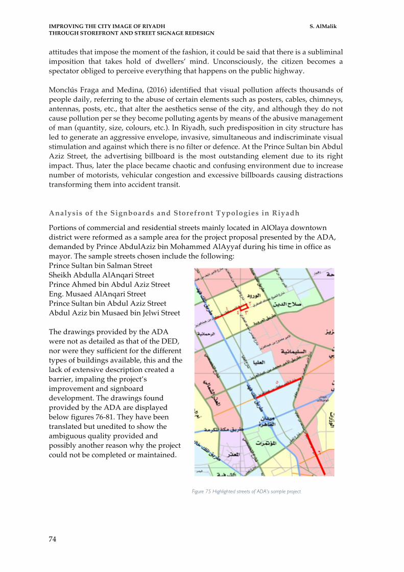
IMPROVING THE CITY IMAGE OF RIYADH S. AlMalik THROUGH STOREFRONT AND STREET SIGNAGE REDESIGN
74
attitudes that impose the moment of the fashion, it could be said that there is a subliminal imposition that takes hold of dwellers’ mind. Unconsciously, the citizen becomes a spectator obliged to perceive everything that happens on the public highway. Monclús Fraga and Medina, (2016) identified that visual pollution affects thousands of people daily, referring to the abuse of certain elements such as posters, cables, chimneys, antennas, posts, etc., that alter the aesthetics sense of the city, and although they do not cause pollution per se they become polluting agents by means of the abusive management of man (quantity, size, colours, etc.). In Riyadh, such predisposition in city structure has led to generate an aggressive envelope, invasive, simultaneous and indiscriminate visual stimulation and against which there is no filter or defence. At the Prince Sultan bin Abdul Aziz Street, the advertising billboard is the most outstanding element due to its right impact. Thus, later the place became chaotic and confusing environment due to increase number of motorists, vehicular congestion and excessive billboards causing distractions transforming them into accident transit. Analysis of the Signboards and Storefront Typologies in Riyadh
Portions of commercial and residential streets mainly located in AlOlaya downtown district were reformed as a sample area for the project proposal presented by the ADA, demanded by Prince AbdulAziz bin Mohammed AlAyyaf during his time in office as mayor. The sample streets chosen include the following: Prince Sultan bin Salman Street Sheikh Abdulla AlAnqari Street Prince Ahmed bin Abdul Aziz Street Eng. Musaed AlAnqari Street Prince Sultan bin Abdul Aziz Street Abdul Aziz bin Musaed bin Jelwi Street The drawings provided by the ADA were not as detailed as that of the DED, nor were they sufficient for the different types of buildings available, this and the lack of extensive description created a barrier, impaling the project’s improvement and signboard development. The drawings found provided by the ADA are displayed below figures 76-81. They have been translated but unedited to show the ambiguous quality provided and possibly another reason why the project could not be completed or maintained.
Figure 75 Highlighted streets of ADA's sample project

IMPROVING THE CITY IMAGE OF RIYADH S. AlMalik THROUGH STOREFRONT AND STREET SIGNAGE REDESIGN
75
Figure 76 section drawing showing two options for signage placement on first floor. one is flushed, the other recessed
Figure 77 Section drawing showing permitted location for pharmacy and clinic banners
Figure 78 Elevation drawing showing position of signage for ground floor shops

IMPROVING THE CITY IMAGE OF RIYADH S. AlMalik THROUGH STOREFRONT AND STREET SIGNAGE REDESIGN
76
Figure 79 Permitted location of signage
Figure 80 Placement of signboards for administrative offices within the building on a freestanding pylon over entryway of building
Figure 81 signboard placement depending on building design and height
Examples of the completed sample project of the ADA and Prince AlAyyaf in 2013 can be seen in the following figures. The top image showing the original state of the signboards before the ADA’s intervention, the middle photo showing the same building after implementing the proposed regulations during the daytime, and finally, the bottom photo showing the effects when lit during the evening.

IMPROVING THE CITY IMAGE OF RIYADH S. AlMalik THROUGH STOREFRONT AND STREET SIGNAGE REDESIGN
77
Figure 82 Free standing pylon of administrative offices within buildings
Figure 83 Before and after images of sample streets implemented in Riyadh

IMPROVING THE CITY IMAGE OF RIYADH S. AlMalik THROUGH STOREFRONT AND STREET SIGNAGE REDESIGN
78
The Pragmatic Value of Signage, Architecture and Advertisement in Urban Landscape This section is aimed at analysing some of the links between advertising and architecture with the intention of assessing if this relationship between signage design and placement can create a positive effect on the city image. As well as, the use of signboards and architecturally planed storefronts and how they can act as an anchor allowing messages to be conveyed accurately to specific targets. This formulation of signage and advertisement around Riyadh can result in a cohesive appearance to the city décor and thus can be helpful to support effective legibility in directing traffic and travel in the city. Consequently, eliminating the problem of confusion caused by city signboards for both drivers and passengers, where too many directions lead nowhere and instead have the tendency to get commuters lost, causing a lot of wasted of time. Jacobs (2010) specified that the generosity of the buildings when converted into media supports media and allows the ubiquity of the advertising phenomenon, improving the segmentation of campaigns and stimulating the creativity of the messages. The new needs of commercial organisations have led to the development of structures of advertising, modifying the urban landscape of cities and improving the optimisation of resources by advertisers. This has led to a push for the inclusion of new technologies as an integral part of infrastructure. Advertising has offered an image of architecture that has been fundamental to its legitimacy and positive valuation by society. Hebbert and Jankovic, (2013) accentuated that the graphic design is an integrative discipline of different methodological and conceptual approaches directed to the construction of visual messages framed within the concept of graphic communication. Further, in the case of graphic design on the street of Riyadh, its effect as an expression and as an actor in the composition of city identity can be approached from areas such as city branding and information design. This proposal presents a vision about the way in which these areas can maintain a respectful relation between signage and city. With emphasis on the legibility of commercials and signs on the vertical plane and the role of design in conforming the urban identity of Riyadh. According to Gevers (2016), it is important to keep in mind that signage as an information organising science uses tools to visualise the design of information and, therefore, nourishes its methods and tools. In both cases, it is a matter of visualisation or visibility: to make visible through the use of artificial techniques of visual representation. The author further accentuated that information design is concerned with the definition, planning and configuration of the contents of a message and the environment in which it is presented with intentions of obtaining objectives by addressing users. In general, it is a transversal discipline that links graphic design with areas of knowledge such as anthropology, architecture or psychology. The design of information starts with the organisation of necessary data its process is then manipulated and organised in such a way as to be useful for the end user (the driver or passenger). It is essential for the signage to catch the attention of users and the a priori knowledge of codes used in agreement with the traditional model of transmission of information. Analysis of Elements Composing the Vertical Plane of Riyadh’s Streets
§ The current situation documented via photographs for a convenient inventory of what can be used, what will have to be removed and what can be modified

IMPROVING THE CITY IMAGE OF RIYADH S. AlMalik THROUGH STOREFRONT AND STREET SIGNAGE REDESIGN
79
§ Development of a road map: to start the project with an updated cartography in which the street addresses appear clearly. If this is not facilitated and available, field work will be necessary until all information is obtained.
§ Classification of elements according to their interest: public and private, their location: internal or external, and their priority or relative importance depending on the urgency of the orientation or the number of people who may need it
§ Determination of itineraries: signage can be constructed and can be placed in places where the drivers will be guided without underlying visual hindrances or contamination.
§ Location of the decision points: Once the signage has been defined, the next step is to establish the decision points of mandatory signalling, which guarantee the driver a correct route to his destination in adequate time to guide him
§ Mark the decision points: The panel placed will mark the direction to follow. To facilitate this work can be done in a classification by colours (blue for external elements and exit ways, magenta for cultural buildings) and with a numerical alpha code, this helps when grouping the panels in the same pole by categories and to later carry out the inventory of signals.
§ Ordering the panels: The arrangement of the signage within a panel is determined by the direction of the arrow leading to the signalled element. Thus, in the case of elements that share direction, the ones with the highest priority should be indicated first. If they match in direction and level, they will be placed in alphabetical order.
§ Definition of each signage: once the project has the panels grouped in posts and ordered according to the direction of the arrow; the application of a homogeneous criteria should be ensured. The new posts and panels will have the same characteristics in terms of: panel dimensions, materials, types of letters (size, typology and capitalisation), use of pictograms, background colours, etc. In addition, this signage can follow the recommendations of ADA and the Ministry of Transportation
§ Preparation of the graphic documentation: the process must be reflected as clearly as possible in a descriptive report of the project, specifications, annexes and their corresponding plans. The project must have at least: descriptive report, detailed plans, basic safety, technical prescriptions and budget.
Traffic Signage and Public Art in Riyadh The ArRiyadh Developmental Authority together with the postal department recently implemented a plan to name each street, lane and district as well as give each building a number; many buildings because of their location on a corner or occupying a full block have two, three or four numbers by each door or entryway. The situation is leaves residents confused even by the number of their own home or office. If the development proposal is managing to incorporate the efforts and join both; traffic signage with post, a simple and most importantly effective system as that of London, Paris and Barcelona can be developed in Riyadh making it easier to navigate and recognise locations. In Riyadh, the time lost trying to return to an exit or highway that was missed, disturbs traffic and aggravates drivers, resulting in an increase of possibility for traffic accidents and penalties. Granted, the application of a developmental plan for street signalling and advertising would radically improve the way people travel and live within the city in a relaxed and well-defined easy to navigate atmosphere. In addition, the uniqueness of each building and displayed art will be self-registered in the minds of the city people making

IMPROVING THE CITY IMAGE OF RIYADH S. AlMalik THROUGH STOREFRONT AND STREET SIGNAGE REDESIGN
80
it much easier for citizens as well as visitors to connect the areas and navigate their whereabouts; as each citizen will develop their own mental image of the city with time and experience. The clarity and uniqueness of architecture that is unmasked will additionally help create important points of reference, public art and significant buildings as orientation points. Consequently, accustoming drivers and passengers to travel through the series of references they obtained with time and experience. (Lynch,1960) An interesting observation noticed is the in the recently completed extension project of AlOrouba road with Abu Bakr street, is the reaction of citizens crossing through for the first time as well as, three years later today. The project was significantly executed where the two roads underpass the Riyadh Airbase. The airbase, also known as the old airport currently hosts the Royal Hall and runways together with the military aviation training and finally the airbase’s infrastructure and facilities. Therefore, specific operational and security requirements were a large consideration throughout the designing and construction phases of the project. All buildings and assembly had to follow international aviation regulations and standards, which requires ensuring operational availability of the base, runways and aviation support services despite construction at all times. (ArRiyadh Development Authority, 2016). The project was designed with a subtle diamond chequered motif in red and white pointing to different directions, North, South, East and West clearly stated on the protective walls that frame the project around the airbase keeping it and cars away from each other. Unfortunately, despite the considerable graphic design efforts, the execution of the project lacks clear numbering and street definition especially those marking exits, many people found themselves disoriented and estranged while trying to exit the highways and tunnels. There are many side by side, unlabelled. The 161 variable-message signs, and 120 signboards (ArRiyadh Development Authority, 2016), have not taken into account clarifying exit numbers and street names leaving those in driving seats as well as their passengers lost. Nonetheless, once drivers managed to memorise which exit leads to which street less mistakes were made. Surprisingly, in an interview with one of the Pakistani residents of Riyadh, Mr. Parvez Khan gladly commented the enjoyment he found when passing through the extension looking at the origami red planes that decorated the projects, he admitted he didn’t mind going through the extension despite it taking a longer amount of time and the probability of him confusing exits to enjoy being a part of the art that allowed the car and those in it to participate in a fixed artistic element that gave a sensation of flight carrying them from one side of the city to the other.
Figure 84 Maidan AlAmir Sattam - Prince Sattam Plaza and detail of origami like planes
The beautifully designed extension lets the car travel through a set of origami planes that move with the car making the ride a three-dimensional art experience of take-off and landing. It is one of the most successful art projects in Riyadh and a massive head turner, and exactly what the city has been lacking for quite some time now. Another beautiful

IMPROVING THE CITY IMAGE OF RIYADH S. AlMalik THROUGH STOREFRONT AND STREET SIGNAGE REDESIGN
81
development project that was recently open to the public is the Bujairy Souk, the area is located around the royal palace, AlMasmaq, a few houses surround the area but the common factor they have is their design. Due to its proximity to the palace and the historical importance it holds all surrounding architecture must express motifs and patterns of original Saudi design, leaving people that live in the neighbourhood with a sense of belonging and unity amongst the community. Traffic Signage and Proposed Information Design The design of information has been used on numerous occasions on city roads as a tool to construct a visualisation of navigational, rules and regulations as well as, political data. It is, in fact, one of the most frequent applications in its relationship with the city but rarely are these graphics noticed as an important part of the urban landscape. Correspondingly, Bocchi et al (2013) established interesting relationships with information architecture and debates regarding visualisation of information in cities through maps, diagrams and schemes, focusing mainly on demographic, architectural and aspects of the urban configuration. It is imperative to understand that the signs in urban environments contribute to strengthen identity, while becoming part of the elements that are on a permanent basis within the landscape contributing to the quality of life. In this way, the signs and laws that are implemented in cities aim, in the first instance, to solve problems of urban life, specifically those related to navigation and circulation to reinforce the identity of the city. Signalling in all road projects is aimed at the implementation of various vehicle traffic control devices, through the establishment of norms relevant for the prevention, traffic regulation and, above all, information to the user of the road, in order to protect their safety and prevent risks and possible accidents. In Riyadh, this project will serve to establish control and directional devices so they are effectively placed, upon meeting essential requirements; such as the existence of a need for its use, the clarity concision of the message. In order to read clearly as well as, reduce visual contamination, the location of the signage must be carefully studied with relation to the driver, the speed, and width of the street. For the driver to be aware of its presence thus taking the implied action. Another important aspect to consider is the design and the uniformity of the signage, so that the combination of its dimensions, colours, shape, composition and visibility, appropriately call the attention of the driver, resulting in a message that is clearly received and legible, giving immediate and timely response to the sign. On the other hand, the application of the sign must be in accordance with the requirements that vehicular traffic requires, that is, it must be designed with the established uniformity, so that the driver can recognise it easily and take precautions with sufficient time to avoid undue risks. The uniformity of the devices is an extremely important aspect, because if it is not fulfilled, it can lead to inaccurate interpretations by the driver, endangering the safety of traffic. Another important aspect to consider is the maintenance of traffic signals or regulatory devices, which must present a preferential service in the cleaning of the signal, so that it is readable at all times by the driver and thus ensure its efficient operation. The timely replacement of the signs that due to traffic circumstances suffer deterioration, breakage and other damages must be carried out immediately, in order to fulfil its mission of ordering and controlling the road traffic. In conclusion, it is possible to establish that the correct signalling of a road, guarantees the vehicular traffic in

IMPROVING THE CITY IMAGE OF RIYADH S. AlMalik THROUGH STOREFRONT AND STREET SIGNAGE REDESIGN
82
normal form, without risks or accidents, unless the recklessness of a driver persists, that ignores the device placed in the way. Degen et al (2015) explained that signage is a discipline of environmental communication and information that guide the decisions and actions of individuals indoors or outdoors where services are provided. The author adds that signage is a discipline of visual communication design that aims to make the use of spaces as easy as possible to individuals. Other definitions provide that the difference between signage and signalling is that carried out in controlled spaces, whereas signalling, is applied in uncontrolled spaces. The city of Riyadh constitutes controlled spaces that are subjected to the command of the local ArRiyadh Development Authority (ADA). Although systems of orientation through signs and signals go back to the beginnings of civilisation, in recent years discipline has acquired scientific value and has become an important part of information design. Signage requires a detailed study of many aspects, including 1. The physical (architectural, urban or geographical) structure of the site to be signalled. 2. The role of public/ private and recreational spaces. 3. The number of people who will use it. Recommendations for Traffic Signage Elements of Urban Orientation
To achieve correct signalling, it is vital that the urban landscape is visually clean; that there is continuity in signalling; that the signals are unobstructed or concealed; that they are homogeneous in terms of colours, letters, pictograms for the driver to get a quick perception; that they are in good state of conservation and that they are accurate in their guidance. Correct placement is essential to avoid bad practices, misuse, becoming an obstacle for drivers and a cause of accidents. Proper and reoccurring maintenance of panels is indispensable for traffic safety, the material of which the signs, their poles and fixation is constructed of must maintain their characteristics against atmospheric agents and must also be reflective. Traffic signage and signalling pursues three objectives: § Increase the safety of the circulation § Increase the efficiency of circulation § Increase the comfort of circulation
Different signal systems have surely coexisted in the streets of Riyadh creating an atmosphere of disorder and lack of continuity over time. An interesting case is presented in Buenos Aires, Argentina, where the signage of the city has been commissioned to the same design studio that developed the identity and signal system for the subway. Owing to the stated example, Abu Dhabi Urban Planning Council with respect to their regulatory policy for commercial signage has designed an architectural portfolio according to the best standards and specifications applicable worldwide thus enabling the Department of Economic Development to implement this project with the results clearly visible in the streets of the Emirate.

IMPROVING THE CITY IMAGE OF RIYADH S. AlMalik THROUGH STOREFRONT AND STREET SIGNAGE REDESIGN
83
CHAPTER IV PROPOSAL

IMPROVING THE CITY IMAGE OF RIYADH S. AlMalik THROUGH STOREFRONT AND STREET SIGNAGE REDESIGN
84

IMPROVING THE CITY IMAGE OF RIYADH S. AlMalik THROUGH STOREFRONT AND STREET SIGNAGE REDESIGN
85
Summary of Proposed Project An enhanced reality is one of the main properties offered by signage. The ability to fuse printed and digital advertisements and signboards within the real environment interactively; creates an exciting feature to the city’s vertical plane, intermediating between communication and the architecture of urban design. The main purpose of this proposal, is a specific focus on improving signage and storefronts in the city of Riyadh. The advantages would result in: 1) a less cluttered vertical plane of the city, that provides a clean canvas for public art. 2) Enhance the city image, create a unified harmonic system of advertisement and signage to retrieve the authenticity and uniqueness of Riyadh. 3) Assure the legibility and ease of travelling throughout the city on a daily basis. The objective was to evaluate the possibility of using previous studies completed in Riyadh and similar cities, with a focus on Abu Dhabi, improve the necessary factors that were found unsuccessful, or inapplicable to declutter the vertical planes of the city, especially the buildings containing signboards of establishments and advertisements of businesses. Furthermore, the objectives include primarily involving the design of commercials and public announcements in the city’s urban design processes. Secondly, suggest budget friendly applications and alternatives where the developed strategies would be suitable for shop owners resulting in a better overall city image of Riyadh. Thirdly, reorganize the majority of city information provided to drivers and passengers on the vertical plane from advertisement, traffic signage, signboards. Finally, ensure the proposal and development plans are multidisciplinary projects in which various professionals such as: graphic designers, industrialists, architects, sociologists, and town planners to name a few, would cooperatively be able to test and prove feasibility of this approach for the overall development of the city’s image. Guaranteeing as well, the new signage regulations are adjusted proportionately to the scale of buildings and street widths and the relationship with the surrounding environment is enriched. The objective of signage and storefront redesign aims to emphasize the importance of using visual language as a necessity of urban communication. It includes signage and advertisement among the tools of urban décor, obliges them to follow specified design regulations of local government and municipal policies. Vertical orientation signs are an essential instrument to guide drivers towards their destinations acting as a tool for traffic management, a presentation card of the municipality, and a part of urban furniture that, if not properly inserted, causes distractions.

IMPROVING THE CITY IMAGE OF RIYADH S. AlMalik THROUGH STOREFRONT AND STREET SIGNAGE REDESIGN
86
PROPOSAL Upon studying the two similar projects completed by the Arriyadh Development Authority in the capital, Riyadh and that accomplished by Abu Dhabi Business Centre of the Department of Economic Development, in Abu Dhabi; the missing key factor from Riyadh’s previous attempt became clear and noteworthy. Primarily, ADA failed to plan their objective for various reasons that revolve around the lack of planning: during the initial phases of the project, new criteria was set for street rehabilitation, pedestrian zones, pavements, vegetation and furniture, were all redesigned and reconstructed thus impaling the execution of the initial objective of improving the city image through storefront and signage redesign within the given deadline. Furthermore, once the mayor in charge was replaced, no substitute was appointed the responsibility of sustaining project development and upkeep. The new mayor had different objectives for city development, resulting in the total loss of the project and its maintenance. The three key factors, aside from the change of mayors and fail to plan can be labelled as: maintenance, finances and time. Moreover, the errors ADA had committed in order to complete the project within the required timeframe they had set was inapplicable. Nevertheless, calculating the successful accomplishments of both projects clarified what Riyadh’s project initially lacked to be a practical application that would be able to expand into the entire city and furthermore be maintained. The following clauses state the potential faults ADA had executed in order to complete the sample project:
§ ADA did not take into consideration the existing state of the sample streets focused more on the design elements and failed to plan update them within the necessary timeframe
§ ADA failed to note the condition of the streets – that lacked proper pedestrian walkways and pavements
§ ADA offered financial help to shop owners who had refused to pay for new signboards – because they had recently been renovated or installed, and a new signboard exceeded their budget – with the costs dividing the expenses between shop owners and ADA, or agreeing to pay the fees entirely
§ ADA did not calculate a suitable or required time shop owners and/or advertisement agencies needed to be able to complete the changes on time
§ ADA did not set cost limits for advertising agencies, nor did they request discount considerations given the fact most of the street was required to change their signboards
§ ADA did not assign a committee responsible for project implementation and maintenance
The consideration of the aforementioned facts led to proposing a basic methodology approach to be implemented for the improvement of Riyadh’s city image through street front and signage redesign. The stages of this approach are:
§ Information stage: Collection and categorization of information. § Research stage: User needs, context, functionality § Design stage: Typological signage study, requirements, psychological and
sociological studies § Decision Stage: Cost/benefit studies, technical studies which will be the limiting
of creative design

IMPROVING THE CITY IMAGE OF RIYADH S. AlMalik THROUGH STOREFRONT AND STREET SIGNAGE REDESIGN
87
§ Maintenance Stage: Dedicated maintenance patrol, yearly taxes, fines for those who do not comply or meet requirements
Upon the completion of the first two stages, a simple yet informative rulebook of all the necessary guides, sizes, materials and design regulations should be prepared by the appointed committee (whose main responsibility is the development, approval and maintenance). The rulebook should then be sent out to all participating design firms and advertisement agencies that have agreed to the conditions of the developmental plan and partook in the project assessment and research stage to comply by. The rulebook must also be available on the official ADA’s website, as well as related and relevant administrative web pages to be as accessible as possible to all. The following suggestions, are grouped per goal objectives;
§ Maintenance o A list of registered and suggested graphic designers and advertisement
agencies should be distributed to shop owners upon the announcement of the project and new set regulations
o Shop owners are completely responsible to complete the required changes as per the new regulations
§ Financial considerations o Graphic designers and advertisement agencies should be given a price
range to be accessible to all shop owners and budgets o Once the given deadline has passed any shop or company that fails to
meet the new requirements will be fined o The ADA can offer to waive the tax payment for one year only (the year
of insinuation) to help shop owners budget the new obliged signboards. This would serve the ADA to complete the project without resorting to any financial indorsements or aid
o Shop owners are financially responsible for the change or alteration of their signboards
§ Time o Advertisement agencies and graphic designers’ necessities should be
taken into consideration before deciding completion dates per their ability to deliver and produce
o The project should approach city by districts o A specific deadline must be given to each district to abide by, for the
progress of the project that maintains the standards and quality necessary o Shop owners must be given enough time to choose the design and
approach they would like to change their storefront, but should also be given a deadline not to exceed or disrupt project phases
Reparability and other objective factors Achieving flexible spaces that last over time means thinking about design premises that allow this basic functionality of public signage. These premises will be part of the process of conceptualising any design aiming to be integrated into the urban space.
§ Quality: Quality is associated with the realisation of solutions suitable for use and deterioration, such as the use of recyclable and durable materials

IMPROVING THE CITY IMAGE OF RIYADH S. AlMalik THROUGH STOREFRONT AND STREET SIGNAGE REDESIGN
88
§ Safety: The safety of citizens should be a basic concept for the realisation of urban space, the adequate interrelation of pedestrian, vehicle, vegetation and furniture must be taken into account
§ Accessibility: The city is free for all, thus, the public space is used interchangeably by any person, for this; barriers or obstacles that do not allow free movement must be removed. Moreover, adapted and integrated elements of inclusion for the deaf, disabled or blind. It is said that 10% of the world population has a limitation, the inclusion or integration of these people in the public space is necessary since the public space must satisfy the wishes or demands of the population
§ Sustainability: The sustainability, from two areas, production and implementation;
o Sustainable production: a production process with low environmental impact, where the optimisation of resources proves the sustainability of the process
o Sustainable implementation: the process of conception of the product in which the purpose is to prolong the useful life of the object and to facilitate or reduce its maintenance
§ Reparability: The use of prefabricated or segmented materials that allow generating additions or replacements
Advantages of Improving Signage and Advertisement and Its Impact on City Image
§ Cohesive design throughout the city § Reduction of visual contamination § Control on quantity of storefront advertisements with a dedicated unified space § Clarification of guidelines for shop owners and advert agencies to abide by § Regulating amount and quality of light omitted from signboards § Lessening energy and electricity costs § Decreasing tax costs on shop owners § Clarity of provided information § Alignment of information and signage
Designing the blueprints for maintenance is crucial to ensure the efforts progress over time and do not relapse into less effective practices. Once the city has been improved, it is important to make sure that any future artistic additions would have a designated space to not clash or overpower existing designs. The plan would be issued officially by the Ministry of Municipal and Rural Affairs, distributed by the ADA to district officials who would print and provide it to each graphic design firm and advertisement agency participating in local signage production. The regulations would also be circulated among new businesses and companies aiming to use signboards to advertise their shops. Additionally, the regulations would be available online for easy access and to be used as a reference to all new and existing business owners and offices. After surveying approximately how many shops, spaces and buildings need to be included in the redesign, a carefully calculated timeframe should be set for a completion date, fines must be known to any individual or company that fails to comply with the set rules. Moreover, a new committee within the ADA must be created not only with the goals of monitoring the changes, in a timely manner, but also, overseeing all future signage and design approval, including size and materials before being mounted. It is suggested that this committee be inclusive of designers, graphic, urban and communicational, phycologists and architects.

IMPROVING THE CITY IMAGE OF RIYADH S. AlMalik THROUGH STOREFRONT AND STREET SIGNAGE REDESIGN
89
Riyadh’s authentic image improvement targets to portray its wealthy character, vitrine the history and tradition it has witnessed and most importantly, offer better services to residents. To summarize this proposal, the approach will enhance elements of the vertical plane specifically, through tackling designs that mask building facades, together with limiting building and storefront illumination. Furthermore, the strategy should include 1) regulations for information cited on signboards. 2) policies for vital traffic signage that is well studied and placed to aid in easy navigation. Implementation of this design policy can result in generous unobstructed space that would, in the future, serve as a clean, unoccupied canvas ready to present artistic features. Eventually, art would impact the city’s overall image, its public spaces and streets, with the various categories of public décor that actively and positively enhance the city image.

IMPROVING THE CITY IMAGE OF RIYADH S. AlMalik THROUGH STOREFRONT AND STREET SIGNAGE REDESIGN
90

IMPROVING THE CITY IMAGE OF RIYADH S. AlMalik THROUGH STOREFRONT AND STREET SIGNAGE REDESIGN
91
CHAPTER V CONCLUSION

IMPROVING THE CITY IMAGE OF RIYADH S. AlMalik THROUGH STOREFRONT AND STREET SIGNAGE REDESIGN
92

IMPROVING THE CITY IMAGE OF RIYADH S. AlMalik THROUGH STOREFRONT AND STREET SIGNAGE REDESIGN
93
CONCLUSION
The city of Riyadh is in its prime development phase and in dire need of a restructured strategy to improve its signage and advertising. The advantages gained by a new program would; first, conserve Riyadh’s authenticity to regain its lost historical character. Second, this would declutter the vertical plane, organising it into a simple and attractive element for the capital. Third, it would improve signboard and signage functionality in day-to-day commuting and navigation. Fourth, it would give new up-and-coming local artists a clean canvas to display their artwork on a city scale. Fifth, a new strategy could enrich civilian sentiment and sense of belonging by adding art to the city, and polishing the city’s image (as indicated by responses to the questionnaire).
It is imperative to keep in mind how individuals interpret information communicated by their city. Today graphic design plays a substantial yet somewhat silent role in city communication it also impacts the quality of services provided by the city. Under given circumstances, residents are enveloped in an ocean of visual communication that whispers, speaks or shouts an infinity of messages rarely perceived consciously. This results in signage and architecture becoming part of a collective unconscious background. Similarly, products of signage and advertising suffer the fate of being invisible as they default into unobserved elements of the landscape. Visual sources provide the capital with an opportunity to define itself and share information in a uniform way. Thus, the omnipresence of signage in the daily happenings of Riyadh becomes a part of the city’s collective identity.
On this occasion, the Arriyadh Development Authority must develop a system forcing commercial entities that publish advertisements to establish a formal relationship that respects order and correspondence among districts and the overall style of various city environments. Statements such as this are verified by Jacobs (2010) who has referred to the relationship of signage and the identity of cities. She explained the need to promote individuality and distinctiveness, connecting them to economic and social growth, and the importance of rethinking on the basis of local demands in the face of globalisation. Likewise, she argues that the most important challenge lies in the wealth of city life, derived from its history and told in various ways. Designers and town planners must be aware of this before adding signage and information to the urban environment and limiting information to only what is necessary, studying placement and positioning to serve Riyadh’s commuters.
In accordance with what has been said, the design of signage and, in general, the systems of information design in Riyadh must be adapted to reflect the uniqueness of the local culture, rather than indulge stereotypes. As discussed in this dissertation, Riyadh is en route to becoming an important business hub, an evolution that is continuously changing its architectural and geographic landscape. Therefore, it is essential that visual communication and information systems be flexible and dynamic enough to adapt to this continuous change while serving the population and the city image at the same time.
The proposal presented in this dissertation aimed to involve Arriyadh Development Authority’s initiative and include demographic opinion as a new contributing actor. The aim is to improve Riyadh’s city image and regain the city’s uniqueness. This consequently

IMPROVING THE CITY IMAGE OF RIYADH S. AlMalik THROUGH STOREFRONT AND STREET SIGNAGE REDESIGN
94
will allow infinite opportunities to construct a framework that can strengthen the country’s Arab identity, enhance the environment, and include art as a permanent element of the public landscape. Moreover, signage maintenance programs would solve problems related to navigation and circulation and, on occasion, reinforce city identity. In this respect, the signalling program will be more efficient as visual signals will be elaborated in accordance with factors that shape the city’s identity.

IMPROVING THE CITY IMAGE OF RIYADH S. AlMalik THROUGH STOREFRONT AND STREET SIGNAGE REDESIGN
95
BIBLIOGRAPHY & APPENDICES

IMPROVING THE CITY IMAGE OF RIYADH S. AlMalik THROUGH STOREFRONT AND STREET SIGNAGE REDESIGN
96

IMPROVING THE CITY IMAGE OF RIYADH S. AlMalik THROUGH STOREFRONT AND STREET SIGNAGE REDESIGN
97
Bibliography
AlsharqAlawsat. (2008). Riyadh: City of Development - ASHARQ AL-AWSAT English. ASHARQ AL-AWSAT English. Retrieved 16 October 2016, from http://english.aawsat.com/2008/01/article55260202/riyadh-city-of-development
Acuto, M., & Rayner, S. (2016). City networks: breaking gridlocks or forging (new) lock-ins?. International Affairs, 92(5), 1147-1166.
Águas, S. (2014). PRÁTICAS EMERGENTES NO DESIGN DO ARTEFACTO URBANO: INTERDISCIPLINARIDADE E CO-DESIGN. Raco.cat. Retrieved 20 January 2017, from http://raco.cat/index.php/Waterfront/article/view/281595
Águas, S. (2012). Do design ao co-design: Uma oportunidade de design participativo na transformação do espaço público. Raco.cat. Retrieved 20 January 2017, from http://raco.cat/index.php/Waterfront/article/view/252044
Ali, A. (2016). Saudi tourism market valued at $45.3b banking on GCC visitors - Saudi Gazette. Saudi Gazette. Retrieved 15 October 2016, from http://saudigazette.com.sa/business/saudi-tourism-market-valued-at-45-3b-banking-on-gcc-visitors/
Alonso, E. E., & Ledesma, A. (2015). High speed railway tunnel crossing of downtown Barcelona: design, construction and performance.
Al-Saud, M. (2016). Foreword | Saudi Vision 2030. Vision2030.gov.sa. Retrieved 3 November 2016, from http://vision2030.gov.sa/en/foreword
AlsharqAlawsat, (2013),(2013) .الجویة القاعدة طرق لمشروع دعمھ على العھد ولي یشكر الریاض أمیر. Archive.aawsat.com. Retrieved 10 November 2016, from http://archive.aawsat.com/details.asp?section=4&issueno=12523&article=720524#.WDt8I3eZPLE
Arab News,. (2016). Development plan for Riyadh is promising, say experts. Arab News. Retrieved 25 October 2016, from http://www.arabnews.com/node/997811/saudi-arabia
Ashraf, N., Glaeser, E. L., & Ponzetto, G. A. (2016). Infrastructure and Development Infrastructure, Incentives, and Institutions. The American Economic Review, 106(5), 77-82.
Assassin, S., de Canales López-Obrero, F. G., Forestier, J. C. N., García-Martin, M., & Gimeno, J. A. M. (2015). 12 PARQUE DE MARÍA LUISA, SEVILLE. Great City Parks, 319.
Bakıcı, T., Almirall, E., & Wareham, J. (2013). A smart city initiative: the case of Barcelona. Journal of the Knowledge Economy, 4(2), 135-148.
Balbo, M., Cancellieri, A., Marconi, G., Marzadro, M., & Ostanel, E. (2012). Contemporary Urban Space and the Intercultural City. Retrieved September, 18, 2012.
Baró, F., Palomo, I., Zulian, G., Vizcaino, P., Haase, D., & Gómez-Baggethun, E. (2016). Mapping ecosystem service capacity, flow and demand for landscape and urban planning: A case study in the Barcelona metropolitan region. Land use policy, 57, 405-417.

IMPROVING THE CITY IMAGE OF RIYADH S. AlMalik THROUGH STOREFRONT AND STREET SIGNAGE REDESIGN
98
BBC News,. (2016). Saudi Arabia profile - Timeline. BBC News. Retrieved 2 February 2017, from http://www.bbc.co.uk/news/world-middle-east-14703523
Bocchi, R., Marini, S., Bertagna, A., & Santangelo, V. (2013). New Life Cycles for Architecture and Infrastructure of City and Landscape. Aracne.
Borja, J. & Muxí, Z. (2003). El espacio público (1st ed.). Madrid: Electa España.
Borja, J., Castells, M., Belil, M., & Benner, C. (1997). Local and Global: The Management of Cities in the Information Age (1st ed.). the University of Michigan: Earthscan Publications.
Boswell, J. (2014). Business Policies in the Making (Routledge Revivals): Three Steel Companies Compared. Routledge.
Brandão, P. (2002). Lisbon images and 4 metaphisical dissertations on waterfront urban design: vision, move, ethics, and interdisciplinarity. On the w@ terfront, (3), 113-131.
Brandão, Pedro. (2011). La imagen de la ciudad,. Estrategias de Identidad y Comunicación. (Vol. Comunicación activa / Ciudad). Barcelona: Publicacions i Edicions de la Universitat de Barcelona.
Brandão, Z. (2006). Urban planning in Rio de Janeiro: a critical review of the urban design practice in the twentieth century. City & Time, 2(2), 4.
Camps-Calvet, M., Langemeyer, J., Calvet-Mir, L., & Gómez-Baggethun, E. (2016). Ecosystem services provided by urban gardens in Barcelona, Spain: insights for policy and planning. Environmental Science & Policy, 62, 14-23.
Castells, M. (1995). La ciudad informacional. Tecnologías de la información, reestructuración económica y el proceso urbano regional. Madrid: Alianza editorial.
City Mayors. (2016). City Mayors: World's fastest growing urban areas (1). Citymayors.com. Retrieved 25 November 2016, from http://www.citymayors.com/statistics/urban_growth1.html
Constant, C. (2012). Modern Architectural Landscape. University of Minnesota Press.
Costa, P., & Lopes, R. (2015). Urban Design, Public Space and the Dynamics of Creative Milieux: A Photographic Approach to Bairro Alto (Lisbon), Gràcia (Barcelona) and Vila Madalena (São Paulo). Journal of Urban Design, 20(1), 28-51.
Da Cruz, F. M. R. (2016). Typifying the Thematic Cities: Study of the Events Organized in Public Spaces in the Cities of Oporto, Vila Nova de Gaia and Barcelona. In Public Spaces: Times of Crisis and Change (pp. 143-168). Emerald Group Publishing Limited.
DED,. (2012). Commercial signage regulation for new licensees started on March 26. Abu Dhabi Department of Economic Development grants 3 months for full implementation of signage organizing regulations. Ded.abudhabi.ae. Retrieved 8 November 2016, from https://ded.abudhabi.ae/en/media-center/news/3-months-for-full-implementation-of-signage-organizing-regulations
DED,. (2013). Abu Dhabi Urban Planning Council - Media Center - End of July the deadline to change signage in Abu Dhabi. Upc.gov.ae. Retrieved 8 November 2016, from

IMPROVING THE CITY IMAGE OF RIYADH S. AlMalik THROUGH STOREFRONT AND STREET SIGNAGE REDESIGN
99
http://www.upc.gov.ae/media-center/press-releases/commercial-signage-regulations.aspx?lang=en-US
Degen, M., & García, M. (2012). The transformation of the ‘Barcelona model’: an analysis of culture, urban regeneration and governance. International journal of urban and regional research, 36(5), 1022-1038.
Degen, M., Melhuish, C., & Rose, G. (2015). Producing place atmospheres digitally: Architecture, digital visualisation practices and the experience economy. Journal of Consumer Culture, 1469540515572238.
Di Masso, A. (2012). Grounding citizenship: Toward a political psychology of public space. Political Psychology, 33(1), 123-143.
Esparza, D. (2014). El diseño del suelo: el papel del pavimento en la creación de la imagen de la ciudad (PhD). University of Barcelona.
Fecht, S. (2012). Grid Unlocked: How Street Networks Evolve as Cities Grow. Scientific American. Retrieved 15 November 2016, from https://www.scientificamerican.com/article/grid-unlocked-how-street/
Fraga, J. M., & Medina, C. D. (2016). From Urbanism to Planning to Urban Project. The pursuit of'urbanity'in Spanish plans and projects. International Planning History Society Proceedings, 17(4).
Gant, A. C., & Rubio, S. P. (2015). Tourism promotion and urban space in Barcelona. Historic perspective and critical review, 1900-1936. Documents d’Anàlisi Geogràfica, 61(3), 461-482.
Garcia-López, M. À. (2012). Urban spatial structure, suburbanization and transportation in Barcelona. Journal of Urban Economics, 72(2), 176-190
Gevers, E. (2013). Maidan Amir Sattam. Gevers-la.com. Retrieved 17 November 2016, from http://www.gevers-la.com/portfolio/aoi-maidan-amir-sattam/
Graute, U. (2016). Local Authorities Acting Globally for Sustainable Development. Regional Studies, 1-12.
Grimaldi, D., & Fernandez, V. (2016). The alignment of University curricula with the building of a Smart City: A case study from Barcelona. Technological Forecasting and Social Change.
Gutiérrez, G. M. (2013). IDENSITAT: A Hybrid Anthropology of Identity, Creativity, and Intervention in Public Spaces. American Anthropologist, 115(2), 313-316.
Haider, H. (2015). All promotional advertisements need approval in Abu Dhabi - Khaleej Times. Khaleejtimes.com. Retrieved 10 November 2016, from http://www.khaleejtimes.com/business/local/all-promotional-advertisements-need-approval-in-abu-dhabi
Hebbert, C. & Jankovic, V. (2013). Cities and Climate Change: The Precedents and Why They Matter - Apr 19, 2013. Usj.sagepub.com. Retrieved 7 November 2016, from http://usj.sagepub.com/content/50/7/1332.full.pdf+htmlSAGE Publications

IMPROVING THE CITY IMAGE OF RIYADH S. AlMalik THROUGH STOREFRONT AND STREET SIGNAGE REDESIGN
100
Hewitt, R. & Gharipour, M. (2016). Contemporary Urban Landscapes of the Middle East, 288.
History.com, Staff. (2010). Standard Oil geologists arrive in Saudi Arabia - Sep 23, 1933 - HISTORY.com. HISTORY.com. Retrieved 10 October 2016, from http://www.history.com/this-day-in-history/standard-oil-geologists-arrive-in-saudi-arabia
Jacobs, Jane. (1961). The Death and Life of Great American Cities. New York: Random House.
Jacobs, J. (2010). The nature of economies. Vintage Canada.
James, S. W. (2012). Indigeneity and the intercultural city. Postcolonial Studies, 15(2), 249-265.
Juris, J. S. (2012). Reflections on# Occupy Everywhere: Social media, public space, and emerging logics of aggregation. American Ethnologist, 39(2), 259-279.
King, G. (1998). The traditional architecture of Saudi Arabia (1st ed.). London: I.B. Tauris.
King Fahad National Library, & Gerber Architekten,. (2014). King Fahad National Library / Gerber Architekten. ArchDaily. Retrieved 19 October 2016, from http://www.archdaily.com/469088/king-fahad-national-library-gerber-architekten
Ksau-hs,. (2014). History of Riyadh. Ksau-hs.edu.sa. Retrieved 22 January 2017, from http://www.ksau-hs.edu.sa/english/lifeincampus/pages/historyofriyadh.aspx
Landry, C., & Wood, P. (2012). The intercultural city: Planning for diversity advantage. Earthscan.
Lynch, K. (1960). The image of the city (Vol. 11). MIT press.
Lynch, K. (1972). What time is this place?. Mit Press.
Lynch, K. (1985). Good City Form. (1981). Barcelona: Gustavo Gili.
Lynch, K., Banerjee, T., & Southworth, M. (1995). City sense and city design: writings and projects of Kevin Lynch. MIT press.
Lynch, Kevin, Banerjee, Tridib and Southworth, Michael, 1990, City sense and city design. Cambridge, Mass.: MIT Press.
Lynch, Kevin, & Rodwin, Lloyd. (1958). A Theory of Urban Form. Journal Fo the American Institute of Planners, 24(4), 201-214.
March, H. (2015). Taming, controlling and metabolizing flows: Water and the urbanization process of Barcelona and Madrid (1850–2012). European Urban and Regional Studies, 22(4), 350-367.
March, H., & Ribera-Fumaz, R. (2014). Smart contradictions: The politics of making Barcelona a Self-sufficient city. European Urban and Regional Studies, 0969776414554488.

IMPROVING THE CITY IMAGE OF RIYADH S. AlMalik THROUGH STOREFRONT AND STREET SIGNAGE REDESIGN
101
Marconi, G. (2015). The Intercultural City: Exploring an Elusive Idea. The Intercultural City. Migration, Minorities and the Management of Diversity.
Marull, J., Font, C., Tello, E., Fullana, N., Domene, E., Pons, M., & Galán, E. (2016). Towards an energy–landscape integrated analysis? Exploring the links between socio-metabolic disturbance and landscape ecology performance (Mallorca, Spain, 1956–2011). Landscape Ecology, 31(2), 317-336.
McGrath, B. (2016). Collecting and Disseminating Knowledge on the Architecture of the Metacity. Urbanisation, 1(1), 13-18.
MEED Projects,. (2015). MEED Projects | KSA projects tracking and analysis platform. Meedprojects.com. Retrieved 10 November 2016, from http://www.meedprojects.com/projects-platform/analysis-tools
Meller, H. (2014). Imagining the Future of Cities through Exhibitions. Exhibitions and the Development of Modern Planning Culture, 19.
Moghaddam, M. S., Assadollahzadeh, T., Mirmoini, M., & Azimi, S. (2013). Examining the City Brand Theory and Presenting Some Solutions for Implementing of It in Iran. Civil Engineering and Architecture, 1(4), 120-124.
Monclus, F. (2000) Barcelona’s Planning Strategies: From ‘Paris of the South to Capital of the West Mediterranean’ Geojournal, 51 Monclus, J. (2003). The Barcelona model: an original formula? From reconstrucción to starategic urban projects (1979-2004). Planning perspectives, vol. 18, n. 4,
Montello, D. R. (2014). Spatial Cognition and Architectural Space: Research Perspectives. Architectural Design, 84(5), 74-79.
Mubarak, F. A. (1995). The role of state in shaping urban forms. In S. Al-Hathloul, & N. Edadan (Eds.), Urban development in Saudi Arabia: Challenges and opportunities (pp. 247–285). Riyadh: Dar Al-Sahan.
Muñoz, F. (2008). Urbanalización (1st ed.). Barcelona: Gustavo Gili.
Musa, M. & Al-Asad, M. (2003). Riyadh Architecture in One Hundred Years » CSBE. Csbe.org. Retrieved 9 October 2016, from http://www.csbe.org/publications-and-resources/articles-and-lectures-on-architectural-issues/riyadh-architecture-in-one-hundred-years/
Newsmanager, (2014), Major Ongoing Construction Projects in Riyadh | -Onsite Exclusives. -Onsite Exclusives. Retrieved 11 November 2016, from https://www.venturesonsite.com/news/major-ongoing-construction-projects-in-riyadh/
Oryxsa,. (2014). Modern architecture in Saudi Arabia. Saudi Arabia News. Retrieved 10 October 2016, from https://oryxsa.com/2014/06/09/modern-architecture-in-saudi-arabia/
Pareja-Eastaway, M. (2012). Construyendo la Barcelona creativa: nuevos actores, nuevas estrategias. Finisterra, 45(90). http://dx.doi.org/10.18055/finis1344

IMPROVING THE CITY IMAGE OF RIYADH S. AlMalik THROUGH STOREFRONT AND STREET SIGNAGE REDESIGN
102
Remesar, A. (2016). New Urban Decorum? Aesthetics To and Fro. En in Gralińska-Toborek;A -Kazimierska-Jerzyk, W (ED) Aesthetic Energy of the City (pp. 19-54). Lodz: Wydawnictwo Uniwersytetu Łódzkiego (Łódź University Press).
Remesar, A. (2015) (2016). City Aesthetics. To and Fro. On New Urban Decorum? (long Version). En Wioletta Kazimierska-Jerzick and Agnieszka Gralińska-Toborek (ED) The Aesthetic Energy of the City”, University of Lodz. Lodz, 2016 (Blueprint). Recuperado a partir de https://www.researchgate.net/publication/299538307_CITY_AESTHETICS_TO_AND_FRO_ON_NEW_URBAN_DECORUM
Remesar, A., & Díaz, M. R. (2015). Barcelona: Paisajes De La Modernidad. On the w@terfront, (35), 5-58. Retrieved 17 December 2016, from http://raco.cat/index.php/Waterfront/article/view/291539/380025
Remesar, Antoni, & García Fortes, Salvador. (2013). Building the New Barcelona. The importance of the survey on common architecture in the Cerda’s Project. En in Joana Cunha Leal, Helena Maia: To and Fro, Modernism and Vernacular Architecture (pp. 129-152). Porto: CEAA.
Ricart, N., & Remesar, A. (2013). Reflexiones sobre el espacio público thoughts on public space. Recuperado a partir de http://www.raco.cat/index.php/Waterfront/article/view/263776
Ricart, N., & Remesar, A. (2013). Reflexiones Sobre El Espacio Público Thoughts On Public Space. On the w@terfront, (25), 5-35.
Remesar, A. (2011). O carácter simbólico da rua, identidade e apropiação. In Brandao, P (ED) A rua é nossa... de todos nós ! Lisboa: MUDE- Instituto Superior Técnico.
Riyadh — at the center of Kingdom’s history. (2016). Arab News. Retrieved 17 October 2016, from http://www.arabnews.com/node/989341/saudi-arabia
Riyadh Chamber, (2016), والنقل الطرق قطاع . Chamber.sa. 2016. Retrieved 2 December 2016, from: http://www.chamber.sa/mainpage/riyadhcity/mainactive/Pages/transportsector.aspx
Roca, E., Aquilué, I., & Gomes, R. (2015). Walking the city. Barcelona as an urban experience. Edicions Universitat Barcelona.
Roigé Montornés, N. (2014). Structural and environmental optimization of DWTDN trenches.
Russia Today, (2016). Saudi Arabia to move from oil, earn more from Hajj. /www.rt.com. Retrieved 11 October 2016, from http://Saudi Arabia to move from oil, earn more from Hajj, (2016). RT International
Salesses, P., Schechtner, K., & Hidalgo, C. A. (2013). The collaborative image of the city: mapping the inequality of urban perception. PloS one, 8(7), e68400.
Saudi Vision 2030,. (2016). Saudi Vision 2030. Vision2030.gov.sa. Retrieved 11 November 2016, from http://vision2030.gov.sa/en/node

IMPROVING THE CITY IMAGE OF RIYADH S. AlMalik THROUGH STOREFRONT AND STREET SIGNAGE REDESIGN
103
Saudi, N. (2011). لشریانا RIYADH l COM l Riyadh .هللا عبد الملك وطریق "خریص" زحام على سیقضي الجدید Airport tunnel - Page 11 - SkyscraperCity. Retrieved 17 October 2016, from http://www.skyscrapercity.com/showthread.php?t=755392&page=11
Sommer, D. (2013). The Work of Art in the World: Civic Agency and Public Humanities. Duke University Press.
Speranza, P., Keisler, K., & Mai, V. (2015). Social Interaction and Cohesion Tool: A Geospatial Analysis Tool to Develop Small Urban Planning for Barcelona’s Superillas. In Proceedings of the Computational Ecologies: Design in the Anthropocene, Association of Computer-Aided Design in Architecture Conference, Cincinnati, Ohio.
Takeuchi, Y., & Perlin, K. (2012, May). ClayVision: the (elastic) image of the city. In Proceedings of the SIGCHI Conference on Human Factors in Computing Systems (pp. 2411-2420). ACM.
The-saudi.net, (2014). Riyadh City History, Saudi Arabia. The-saudi.net. Retrieved 18 October 2016, from http://www.the-saudi.net/saudi-arabia/riyadh/Riyadh%20History.htm
The-saudi.net, (2014). Riyadh City Profile, Saudi Arabia. The-saudi.net. Retrieved 14 October 2016, from http://www.the-saudi.net/saudi-arabia/riyadh/Riyadh%20City%20-%20Saudi%20Arabia.htm
Tøndering, C. (1997). The Islamic Calendar. Webexhibits.org. Retrieved 17 October 2016, from http://www.webexhibits.org/calendars/calendar-islamic.html
United Nations, Department of Economic and Social Affairs,. (2015). PopulationPyramid.net. PopulationPyramid.net. Retrieved 11 October 2016, from http://PopulationPyramid.net
Urbano, J. (2016). The Cerdà Plan for the Expansion of Barcelona: A Model for Model City Planning. Focus, 12(1), 13.
Vidal, T., Valera, S., & Peró, M. (2010). Place attachment, place identity and residential mobility in undergraduate students. Psycology: Revista Bilingue De Psicologìa Ambiental, 1(3), 353-369. http://dx.doi.org/10.1174/217119710792774799
Vidal, T., Berroeta, H., de Masso, A., Valera, S., & Peró, M. (2013). Apego al lugar, identidad de lugar, sentido de comunidad y participación en un contexto de renovación urbana. Estudios De Psicología, 34(3). http://dx.doi.org/10.1174/021093913808295172
Valera, S. (1997). Estudio de la relación entre el espacio simbólico urbano y los procesos de identidad social. Revista De Psicología Social, 12(1), 17-30. http://dx.doi.org/10.1174/021347497320892009
Wiechmann, T., & Bontje, M. (2015). Responding to tough times: Policy and planning strategies in shrinking cities. European Planning Studies, 23(1), 1-11.
Williams, R. J., Iglesias-Fernández, J., Stepper, J., Jackson, A., Thompson, A. J., Lowe, E. C., ... & Williams, S. J. (2014). Combined Inhibitor Free-Energy Landscape and Structural Analysis Reports on the Mannosidase Conformational Coordinate. Angewandte Chemie International Edition, 53(4), 1087-1091.

IMPROVING THE CITY IMAGE OF RIYADH S. AlMalik THROUGH STOREFRONT AND STREET SIGNAGE REDESIGN
104
World Weather,. (2016). Riyadh, Ar Riyad Weather Averages | Monthly Average High and Low Temperature | Average Precipitation and Rainfall days | World Weather Online. Worldweatheronline.com. Retrieved 15 October 2016, from https://www.worldweatheronline.com/riyadh-weather-averages/ar-riyad/sa.aspx Yalman, Suzan. (2001). “The Art of the Mamluk Period (1250–1517).” In Heilbrunn Timeline of Art History. New York: The Metropolitan Museum of Art, 2000–. http://www.metmuseum.org/toah/hd/maml/hd_maml.htm (October 2001) Zygiaris, S. (2013). Smart city reference model: Assisting planners to conceptualize the building of smart city innovation ecosystems. Journal of the Knowledge Economy, 4(2), 217-231.

IMPROVING THE CITY IMAGE OF RIYADH S. AlMalik THROUGH STOREFRONT AND STREET SIGNAGE REDESIGN
105
Index of Images Figure 1 Riyadh Skyline, Timeline - Omaima AlAzhari ........................................................ 13 Figure 2. The Islamic Empire 750 C.E. ...................................................................................... 16 Figure 3 The Great Mosque of Xi'an, China -Rashidun Caliphate Figure 4 Ibn Tulun Mosque, Cairo -Abbasid Caliphate ......................................................... 17 Figure 5 Al Hambra Fortress, Andalusia, Spain -Umayyad Caliphate Figure 6 The Great Mosque of Samarra, Iraq -Abbasid Caliphate ....................................... 17 Figure 7 AlAzhar Mosque and University, Cairo -Fatimid Caliphate Figure 8 Funerary of Sultan Qaytbay, Cairo –Mamluk Caliphate 18 Figure 9 Administrative Regions of the Kingdom of Saudi Arabia and surrounding GCC
countries and neighbours ................................................................................................... 19 Figure 10 Houses in Khamis Mushayt with terraces. Asir Region south-west Saudi
Arabia. Made of mud and stone to protect from the rain, the thick walls a keep the cool temperature during summer. ..................................................................................... 20
Figure 11 Rijal Alma village located in the Asir province, it is made almost entirely of stone, and considered one of the main tourist attractions of the region. ..................... 20
Figure 12Ttraditional multi-storey adobe and brick house in Najran called a Midmakh building, it reflects the Yemeni influence in the province. Windows are smaller on lower floors for heat prevention and privacy, while on higher floors they are larger for air circulation and sunlight. ......................................................................................... 20
Figure 13 The "Musharabiyat" of old Jeddah, wooden elements covering windows and decorating the buildings in the Hijaz region. The green and turquiose colored "Roshan" are found on special buildings in Medina and Mecca ................................... 21
Figure 14 Al-Hijr (Madain Salih) – Archaeological site. The largest conserved site of the civilization of the Nabataeans (of Petra, Jordan), AlHijir is located in the Medina region. .................................................................................................................................... 21
Figure 15 Early Riyadh, palaces of the historical Al Diryia and Palace of Saad bin Saud in the capital. ............................................................................................................................. 22
Figure 16. Location of Riyadh province, the capital of the Kingdom of Saudi Arabia ...... 23 Figure 17 Bird's eye view of Riyadh early 1900s Figure 18 AlMasmak Fortress and Palace within the Dariyah walls ................................... 28 Figure 19 The Royal Palace, Qasr AlHukm Figure 20 Justice Square, Sahet AlAdel 28 Figure 21 The Square Palace, Qasr AlMurabba Figure 22 AlMasjid AlJami' and Qasr Alhukm post renovation ........................................... 29 Figure 23 Riyadh Skyline, early 1900s ...................................................................................... 29 Figure 24 AlMalaz Residential & Commercial Expansion Project ....................................... 30 Figure 25 Riyadh city expansion during King Saud's reign .................................................. 31

IMPROVING THE CITY IMAGE OF RIYADH S. AlMalik THROUGH STOREFRONT AND STREET SIGNAGE REDESIGN
106
Figure 26 The 6 and 10 storey apartment buildings of 1959 Figure 27 Zahret AlRiyadh Building 31 Figure 28 The Riyadh Water Tower Figure 29 The Riyadh Equestrian Club ............ 32 Figure 30 Construction Phases of the Riyadh Water Tower .................................................. 32 Figure 30 The Dioxiadis Master Plan of Riyadh ...................................................................... 33 Figure 32 Riyadh Skyline 1930s-1980s ...................................................................................... 34 Figure 33 Ministry of Rural and Municipal Affairs ................................................................ 34 Figure 34 Ministry of Foriegn Affairs designed by Henning Larsen Figure 35 Saudi Television Tower 35 Figure 36 AlFaisaliah Tower and Commercial Centre Figure 37 AlMamlaka Tower and Commercial Centre 35 Figure 38 Saudi Arabian National Museum ............................................................................ 36 Figure 39 Ministry of Interior Affairs Figure 40 King Khalid International Airport, interior view .................................................. 37 Figure 41 King Fahad Stadium .................................................................................................. 37 Figure 42 Dimplomatic Quarter of Riyadh .............................................................................. 37 Figure 43 The Great Mosque 1992 ............................................................................................. 37 Figure 44 King Fahad National Library 1988 ........................................................................... 38 Figure 45 King Fahad National Library - Present ................................................................... 38 Figure 46 King Fahad National Library Architectura Phases Figure 47 King Fahad National Library interior view - Present ........................................... 38 Figure 48 Render of King Abdulla Financial District (KAFD) .............................................. 39 Figure 49 Princess Noura bint Abdulrahman University Campus ...................................... 39 Figure 50 Skyline of Riyadh - 1930 ............................................................................................ 40 Figure 51 Riyadh Skyline - 1980 ................................................................................................. 40 Figure 52 Riyadh Skyline - Present ............................................................................................ 40 Figure 53 Graffiti limited to shutter doors and storefronts for advertisment during
closing hours ......................................................................................................................... 53 Figure 52 Mezanine signboard placement ............................................................................... 69 Figure 53 Ground floor signboard placement ......................................................................... 69 Figure 56 Permitted location of signboards on glass buildings ............................................ 69 Figure 57 Permitted signboard design for ground floor advertisements ............................ 69 Figure 58 Permitted signboard design for mezzanine advertisements ............................... 69 Figure 59 Permitted location for signboards on top of glass buildings ............................... 70 Figure 60 Permitted signboards for businesses at the top of the building or on the
building’s body (Those with a background are to be used on glass buildings for ease of legibility) ........................................................................................................................... 70

IMPROVING THE CITY IMAGE OF RIYADH S. AlMalik THROUGH STOREFRONT AND STREET SIGNAGE REDESIGN
107
Figure 61 Position of signboard within covered passages Figure 62 Position of signboards within arches 70
Figure 63Permitted signboards for businesses on groundfloors in covered passage and between arches ..................................................................................................................... 70
Figure 64 Permitted location of ground floor signboards on passage exterior and interior................................................................................................................................................. 71
Figure 65 Permitted signboards for businesses on passage exterior and interior .............. 71 Figure 66 Permitted locations for signboards on Villas and surrounding fence/walls .... 71 Figure 67 Signboard design permitted on Villas ..................................................................... 71 Figure 68 Permitted signboards for closed storage and warehouses ................................... 72 Figure 69 Permitted signboard location for open storage structures Figure 70 Additional
permitted location for signboards on warehouses .......................................................... 72 Figure 71 Permitted location of signboards on industrial buildings and surrounding
fence/wall ............................................................................................................................. 72 Figure 72 Permitted designs of signboards for warehouses, opened and closed structures
of storage, industrial areas and surrounding walls ........................................................ 72 Figure 73 Permitted location for signboards on passages and entryways of industral
areas ....................................................................................................................................... 72 Figure 74 Permitted designs for passage and entryway signboards in industrial zones .. 72 Figure 73 Highlighted streets of ADA's sample project ......................................................... 74 Figure 76 section drawing showing two options for signage placement on first floor. one
is flushed, the other recessed .............................................................................................. 75 Figure 77 Section drawing showing permitted location for pharmacy and clinic banners
................................................................................................................................................. 75 Figure 78 Elevation drawing showing position of signage for ground floor shops .......... 75 Figure 79 Permitted location of signage ................................................................................... 76 Figure 80 Placement of signboards for administrative offices within the building on a
freestanding pylon over entryway of building ............................................................... 76 Figure 81 singboard placement depending on building design and height ....................... 76 Figure 82 Free standing pylon of administrative offices within buildings ......................... 77 Figure 83 Before and after images of sample streets implemented in Riyadh .................... 77 Figure 84 Maidan AlAmir Sattam - Prince Sattam Plaza and detail of origami like planes
................................................................................................................................................. 80

IMPROVING THE CITY IMAGE OF RIYADH S. AlMalik THROUGH STOREFRONT AND STREET SIGNAGE REDESIGN
108
I See You Riyadh - Omaima AlAzhari
Riyadh Skyline is an illustrative artwork done by Saudi artist Omaima Alazhari. Born and raised as a Saudi citizen herself, she created this work to follow through her Arabic teachings and therefore intended for the work to be read from right to left. The depiction moves through Riyadh’s skyline simultaneously with its historical timeline via architecture. Like most female Saudi artists whose artworks are usually created containing political purposes; in I See You Riyadh, Alazhari created a piece with specific buildings of the skyline all featuring at least one eye. These eyes symbolize several different aspects the artist intended to portray. For instance, the importance of social obligations, people’s reputations and the judgmental stereotype. The eyes are also a representation of the sarcastic eye to the surroundings, portraying the nosiness in Saudi’s (specifically in the capital’s) locals. Through embracing the history and the context of the city she created a political purpose and represented the citizen through architecture. One can also read these symbolic eyes as a representation of the religion in which it states: “(30) Say to the believing men that they should lower their gaze and guard their modesty: that will make for greater purity for them: And Allah is well acquainted with all that they do.” – The Holy Quran, Ch. 24 AlNoor.
Alazhari may well be equally trying to warn citizens of the lack of religion she witnesses and its misinterpretation.

IMPROVING THE CITY IMAGE OF RIYADH S. AlMalik THROUGH STOREFRONT AND STREET SIGNAGE REDESIGN
109
Definitions and Terminology of Relevant Arabic Vocabulary and Terms AlAalam AlIslami, الميالعالم اإلس : The Islamic world AlAalam AlArabi, العالم العربي: The Arab World, 22 Arabic-speaking countries also known as the Arab nation AlSharq AlAwsat, الشرق األوسط: The middle east, the transcontinental territory of Western Asia and Egypt. Majlis AlTaawon Lidowal AlKhaleej, مجلس التعاون لدول الخلیج: The Gulf Corporation Council – GCC: The intergovernmental political and economic union of the region of Arab states: Bahrain, Kuwait, Oman, Qatar, Saudi Arabia, and the United Arab Emirates sharing the coast of the Arabian Gulf, except for Iraq. Mamlaka, مملكة: Kingdom Dawlah, دولة: Country Balad, بلد: Country Madina, مدینة: City Easima, عاصمة: Capital city ‘Ard, أرض: Land Mawqie, موقع: Site, location Hudoud, حدود : Boarders Sahra’a, صحراء: Desert Jabal, جبل: Mountain Hadaba, ھضبة: Plateau Wadi, وادي: Valley Bahhr,بحر: Sea Khaleej, خلیج: Gulf Maïdan, میدان: Roundabout Saaha, ساحة: Plaza, square Muntazah, منتزه: Recreational area Soûq, Suq, سوق: Commercial centre Soor, سور : The city rampart Mabna, مبنى: Building Amaara, عمارة: Building Wajihat almabna, واجھة المبنى: Building façade Zawiya, زاویة: Corner Sharie. شارع : Street Ttariq, طریق:Road Alttariq alssarie, الطریق السریع: Highway Llawhha, لوحة: Board Dieaya, دعایة: Advertising, publicity Al'iielan, االعالن: Announcement, advertisement Tassawor, تصور: Visualisation, imagination, conception Anthima, األنظمة: Regulations, system Qawanin, قوانین: Regulations, laws Qanon, قانون: Law, rule Tarteeb, ترتیب: Order, arrangement Tiraz, طراز: Style

IMPROVING THE CITY IMAGE OF RIYADH S. AlMalik THROUGH STOREFRONT AND STREET SIGNAGE REDESIGN
110
Madani, مدني: Urban Binaa, بناء: Construction Malek, ملك: King Amir, أمیر: Prince Sheikh, شیخ: Cleric Bin, بن: the son of, typically used when introducing someone i.e. Mohammed bin Salman Muhandis, مھندس: Engineer Muhandis Muemari, مھندس معماري: Architect Musammem, مصمم: Designer AlMukhattet, المخطط: Planner Muatin, مواطن: Civilian, citizen Mmuqim, مقیم: Resident Ummah, أمة: Nation or community AlMukhattat, المخطط: Plan Masjid, Jamie, Mussalla, مسجد، جامع، مصلى: Mosque, Prayer Room Salaat, صالة: Prayer Fajr،فجر: Dawn Dhuhur, ظھر : Noon Assir عصر، : Afternoon Maghreb مغرب، : Dusk, sunset Eisha ،عشاء: Evening

IMPROVING THE CITY IMAGE OF RIYADH S. AlMalik THROUGH STOREFRONT AND STREET SIGNAGE REDESIGN
111
Questionnaire distributed November 2016 amongst 904 participants.
89%
7% 4%
Yes I visit often No
1. Do you live in Riyadh?
48%
24% 28%
Yes No Neutral
2. Do you consider Riyadh to be a beautiful city?
25%
49%
26%
Yes No Neutral
3. Do you consider Riyadh to be a well organised city?
1% 1% 4%
53% 56%
Walking Bicycle Public transportation
Car - I drive Car - Chauffeur services
4. Which of the following do you use to commute around Riyadh?

IMPROVING THE CITY IMAGE OF RIYADH S. AlMalik THROUGH STOREFRONT AND STREET SIGNAGE REDESIGN
112
15%
53%
32%
Yes, the architecture is unique and original
No, the architecture is repetitive and unoriginal
Neutral
5. Do you believe Riyadh has a unique architectural and/or artistic identity?
16% 17%
68%
Yes, I am bothered by them Yes, I enjoy them No, I am not affected
6. Do you feel affected at home or in the office by the city lights and street advertisements?
22%
47%
31%
Yes, I do No, I do not Neutral
7. Do you notice art on the streets, in plazas, on buildings of Riyadh?
26%
70%
23%
Easily, the names of establishments are written
clearly (good font, design, size, colors)
I use gps (maps, google maps, others)
With difficulty, the signage is unclear (clashing designs in one
space, confusing, insufficient lighting, etc.)
8. How do you find shops and stores in Riyadh?

IMPROVING THE CITY IMAGE OF RIYADH S. AlMalik THROUGH STOREFRONT AND STREET SIGNAGE REDESIGN
113
51%
29% 20%
Yes, they are labeled clearly and are easy to see
I use gps No, it is difficult, information is unclear and hard to find
9. Do you find it easy to read the street names, exit numbers and traffic signage in Riyadh?
32%
44%
24%
Yes No Neutral
10. Do you find that street signage and numbering is up to date with the development and changes happening in Riyadh?
39% 37%
24%
Yes No Neutral
11. Do you believe storefront signage and publicity is visually polluting Riyadh?
23% 19%
78%
17%
Architects, engineers Urban Designers Riyadh Municipality I do not know
12. Who do you think is responsible for city decor?

IMPROVING THE CITY IMAGE OF RIYADH S. AlMalik THROUGH STOREFRONT AND STREET SIGNAGE REDESIGN
114
70% 73% 75%
40%
1% 1% 1% 2%
Has a positive effect on people
Reflects the city's image and culture
Gives the city
character
Gives a sense of
belonging to its citizens
Has no effect
Pollutes the city
Is a waste of space
Has a negative effect on people
13. In what way does public art (sculptures, murals and monuments) affect people and space?
35% 35%
23% 20% 22%
Informative Artistic Distracting Overwhelming Neutral
14. Which of the following do you consider advertisements on the streets of a city?
6% 2%
40%
24% 28%
Act immediately, call the police or department in
charge
Ask family or staff to take action
I did not know I could do anything
Do nothing, it is none of my concern
Do nothing, no one will listen to my
complaint
15. When you see malfunctioning signage, burnt lights, misplaced/ broken elements on the street, what do you do?
28%
58% 65%
16% 24%
Going to public places, parks (outdoors)
Going to shopping centres, restaurants
(indoors)
Visiting friends and family
Attending public events/exhibitions in the city (shows, plays, competition,
etc.)
Attending private events/exhibitions
in the city (galleries, shows, bazaars, etc.)
16. Which do you consider when in search for entertainment?

IMPROVING THE CITY IMAGE OF RIYADH S. AlMalik THROUGH STOREFRONT AND STREET SIGNAGE REDESIGN
115
28%
45%
73%
41%
3% 6% 4%
30%
Far East Asia
The Arab world
Europe North America
South America
Africa Australia Other cities in Saudi Arabia
17. Which regions do you travel to?
28%
66%
6%
Yes, the street names and number system is clear
I use gps No, I find it difficult, I can not find my way
18. When traveling, do you find it easy to understand the streets and know where you are going?
79%
12% 10%
Yes No Neutral
19. When traveling, do you notice public art?
71%
15% 14%
Yes No Neutral
20. Do you notice differences between Riyadh and other cities, storefronts, billboards and other forms of advertisement when traveling?