Embed Size (px)
Citation preview

Prepared for:
Water Utility Climate Alliance The Central Arizona Project, Denver Water, the Metropolitan Water District of Southern
California, the New York City Department of Environmental Protection, the Portland Water Bureau, the San Diego County Water Authority, the San Francisco Public Utilities Commission,
Seattle Public Utilities, the Southern Nevada Water Authority, and Tampa Bay Water
Project Manager: David Behar, San Francisco Public Utilities Commission Contract Manager: Keely Brooks, Southern Nevada Water Authority
Lead Author Jason M. Vogel
Contributing Authors
Joel B. Smith, Stratus Consulting Megan O’Grady, Stratus Consulting Paul Fleming, Seattle Public Utilities Kavita Heyn, Portland Water Bureau
Alison Adams, Tampa Bay Water Don Pierson, New York City Department of Environmental Protection
Keely Brooks, Southern Nevada Water Authority David Behar, San Francisco Public Utilities Commission
May 2015
Actionable Science in Practice: Co-producing Climate Change Information for Water Utility
Vulnerability Assessments
Final Report of the Piloting Utility Modeling Applications (PUMA) Project

Piloting Utility Modeling Applications Project Final Report Stratus Consulting
Table of Contents
Acknowledgments ......................................................................................................................... ii
List of Acronyms .......................................................................................................................... iii
Executive Summary ...................................................................................................................... v
Section 1 Introduction ........................................................................................................... 1
Section 2 PUMA Project Process ......................................................................................... 5
Section 3 PUMA Project Outcomes: Four Utility Project Profiles ................................... 7
3.1 New York City Department of Environmental Protection ..................................... 8 3.1.1 NYCDEP’s PUMA project summary ......................................................... 8 3.1.2 NYCDEP issues of interest ......................................................................... 9 3.1.3 How the PUMA project will affect utility decisions ................................ 12
3.2 Portland Water Bureau .......................................................................................... 14 3.2.1 PWB’s PUMA project summary .............................................................. 14 3.2.2 PWB issues of interest .............................................................................. 15 3.2.3 How the PUMA project will affect utility decisions ................................ 19
3.3 Seattle Public Utilities........................................................................................... 20 3.3.1 SPU’s PUMA project summary ................................................................ 20 3.3.2 SPU issues of interest................................................................................ 21 3.3.3 How the PUMA project will affect utility decisions ................................ 24
3.4 Tampa Bay Water ................................................................................................. 25 3.4.1 TBW’s PUMA project summary .............................................................. 25 3.4.2 TBW issues of interest .............................................................................. 26 3.4.3 How the PUMA project will affect utility decisions ................................ 29
Section 4 Conclusions for an Applied Research Agenda for Climate Services ............. 30
References ............................................................................................................ 33
Suggested Resources ........................................................................................... 35
Appendix A Applying Climate Model Outputs 101 for Water Utilities ............................ A-1
Appendix B PUMA Project Points of Contact..................................................................... B-1
Page i

Piloting Utility Modeling Applications Project Final Report Stratus Consulting
Acknowledgments The authors of this report would like to thank the Water Utility Climate Alliance (WUCA) in general and Piloting Utility Modeling Applications (PUMA) project members in particular for funding and supporting this project. We highly appreciate the guidance provided during the course of the project by the WUCA members that participated: Alan Cohn, Elliot Schneiderman, and Lorraine L. Janus, New York City Department of Environmental Protection; Lorna Stickel and Edward Campbell, Portland Water Bureau; and Tirusew Asefa, Tampa Bay Water.
In addition, we would like to express our gratitude to the following PUMA climate science counterparts for their valuable input throughout the project and for this report:
The Pacific Northwest Climate Impacts Research Consortium, including:
Dr. Philip Mote, Ms. Megan Dalton, and Ms. Kathie Dello, Oregon State University
Dr. Bart Nijssen and Ms. Tzu-Hsin Cindy Chiao, University of Washington Dr. John Abatzoglou and Dr. Katherine Hegewisch, University of Idaho
Ms. Wendy Graham, University of Florida
Ms. Aavudai Anandhi Swamy, Kansas State University.
Page ii

Piloting Utility Modeling Applications Project Final Report Stratus Consulting
List of Acronyms AR IPCC Assessment Report AR4 IPCC Fourth Assessment Report AR5 IPCC Fifth Assessment Report BCCA Bias-correction and constructed analog BCSA Bias-correction and stochastic analog BCSD Bias-correction and spatial disaggregation CCAWWG Climate Change and Water Working Group CCRUN Consortium for Climate Risk in the Urban Northeast CDF Cumulative distribution function CIRC Climate Impacts Research Consortium CMIP Coupled Model Intercomparison Project CMIP3 Coupled Model Intercomparison Project Phase 3 CMIP4 Coupled Model Intercomparison Project Phase 4 CMIP5 Coupled Model Intercomparison Project Phase 5 COAPS Center for Ocean-Atmospheric Prediction Studies CUNY City University of New York DHSVM Distributed Hydrology-Soil-Vegetation Model FSU Florida State University GCM General circulation model or global climate model GHG Greenhouse gas GIS Geographic information system IPCC Intergovernmental Panel on Climate Change MACA Multivariate Adaptive Constructed Analog NASA-GISS NASA Goddard Institute for Space Studies NCAR National Center for Atmospheric Research NOAA National Oceanic and Atmospheric Administration NYCDEP New York City Department of Environmental Protection OSU Oregon State University
Page iii
Piloting Utility Modeling Applications Project Final Report Stratus Consulting
PRISM Parameter-elevation Relationships on Independent Slopes Model PRMS Precipitation-runoff Modeling System PUMA Piloting Utility Modeling Applications PWB Portland Water Bureau RCM Regional climate models RCP Representative Concentration Pathway RISA Regional Integrated Sciences and Assessments SD Statistically distributed SDBC Spatial disaggregation and bias-correction SDSM Statistical Downscaling Model SECC Southeast Climate Consortium SPU Seattle Public Utilities SRES Special Report on Emissions Scenarios TAR IPCC Third Assessment Report TBW Tampa Bay Water UF University of Florida UID University of Idaho USGCRP U.S. Global Change Research Program USGS U.S. Geological Survey UW University of Washington VIC Variable Infiltration Capacity WRF Weather Research and Forecasting WUCA Water Utility Climate Alliance
Page iv
Piloting Utility Modeling Applications Project Final Report Stratus Consulting
Executive Summary This report documents a collaborative Water Utility Climate Alliance effort, the Piloting Utility Modeling Applications (PUMA) project. The PUMA project was an effort to produce actionable science through close collaboration between climate experts and utility personnel to meet the needs of four water utilities. Instead of asking climate experts what they thought utilities should do regarding climate change, four WUCA utilities agreed to forge partnerships with scientific institutions to explore how to integrate climate considerations into their specific management context.
This report documents those four utilities’ experience between the start of the PUMA project in 2010 and the writing of this report in late 2014. A fundamental goal of this report is to draw lessons from these four distinct projects regarding best practices in the co-production of actionable science. We attempt to display how each team went about tailoring climate information to specific decision-maker needs, show what worked and did not work, and inform future research and investment along the boundary between climate science and adaptation decision-making.
Below is a big-picture summary of our conclusions, based on the experience of all four PUMA utilities:
Assessment was local, and one size did not fit all. Although each PUMA project sought to illuminate a similar question – the impact of climate change on drinking water supplies – the four utilities pursued widely different approaches in service of that goal.
The scientist and utility-manager learning process was a two-way street. In practice, the climate modelers themselves often had as much to learn about how water utilities model their systems as the water utility personnel had to learn about how climate modelers project future climate.
Water utilities sometimes needed to customize approaches to using climate model output. General circulation model (GCM) output, downscaling techniques, and even baseline observational datasets used to validate climate projection tools frequently needed to be customized for use in local assessments; this included correcting these climate model outputs to accurately reflect local conditions.
Utilities required flexibility in exploring different methods to use climate model output. Each of the PUMA utilities followed a different path, using different data, models, and techniques to get started and learn about climate change in general and enhance applicability to local circumstances in particular.
Page v
Piloting Utility Modeling Applications Project Final Report Stratus Consulting
Utilities found that they needed to consider using a bottom-up as well as a top-down approach to climate modeling. A bottom-up approach begins by asking what is important in the context of a specific utility and a top-down approach begins by exploring what the science can tell us about how climate may change. PUMA utilities found value in both approaches.
Information on changes in extreme event impacts was a major need for water utilities. Although climate models do not easily capture extreme events, such events were the most sought-after projections for many of the utilities’ PUMA projects.
Understanding local hydrology was critical. A good understanding of local hydro-meteorology was important in understanding the impacts of changes in temperature, precipitation, solar radiation, winds, and other key variables on water supply sources.
Utilities and scientists learned to adopt a “don’t hesitate to innovate” strategy. Some of the most successful aspects of the PUMA project occurred when water utilities and their scientific partners decided to create something new to meet their needs.
For lessons learned on a case-by-case basis, please refer to each case in Sections 3.1 through 3.4; for detailed conclusions across the project, please see Section 4: Conclusions for an Applied Research Agenda for Climate Services.
Page vi
Piloting Utility Modeling Applications Project Final Report Stratus Consulting
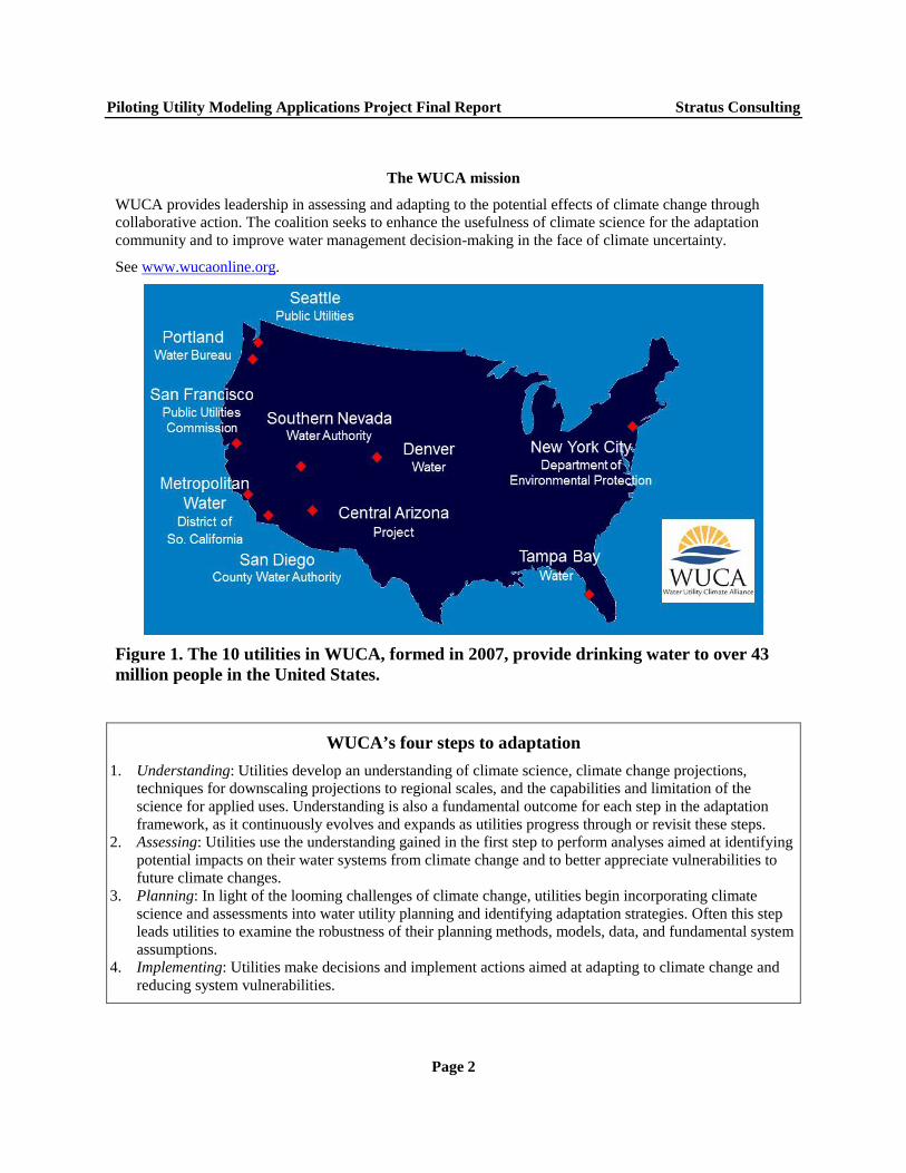
1. Introduction The Water Utility Climate Alliance (WUCA) is a coalition of 10 of the nation’s largest water providers (see Figure 1).1 Together, they supply drinking water for more than 43 million people in the United States. WUCA was formed in 2007 to better understand the effects of climate change on water-related infrastructure and water resource supplies. In addition to sharing the coalition’s experiences with independently assessing climate vulnerability and identifying adaptation actions, WUCA has engaged in a number of collaborative efforts to advance the understanding of available climate science and how it can support water resource decision-making. The coalition has also published two white papers: one on improving climate modeling in support of water utilities, and a second on decision support planning methods. Both are available online (http://www.wucaonline.org).
This report documents a new collaborative WUCA effort, the Piloting Utility Modeling Applications (PUMA) project. This report describes the lessons learned from four WUCA case studies focused on understanding and assessing science products for use in vulnerability assessments (see the text box, WUCA’s four steps to adaptation).
Along with the release of this report, WUCA is releasing another white paper featuring case studies of utilities that are actively engaged in step three of the framework, planning. The case studies highlighted are incorporating climate vulnerability assessments into decision-making processes as diverse as long-term water supply planning and day-to-day capital investment decisions. In many cases utilities have added to or completely changed their planning models and methods to properly address climate change and other future challenges. This companion white paper, Embracing Uncertainty: A Case Study Examination of How Climate Change is Shifting Water Utility Planning, is also available online (http://www.wucaonline.org).
Formally, the goal of the PUMA project is “…to identify state-of-the-art modeling tools and techniques that can be used by water utilities to assess potential climate change impacts on their systems and watersheds.” However, the motivation for the PUMA project also includes collaborating with climate scientists to generate an applied research agenda developed through the experience of four member utilities.
1. WUCA member utilities include the Central Arizona Project, Denver Water, the Metropolitan Water District of Southern California, the New York City Department of Environmental Protection, the Portland Water Bureau, the San Diego County Water Authority, the San Francisco Public Utilities Commission, Seattle Public Utilities, the Southern Nevada Water Authority, and Tampa Bay Water.
Page 1
Piloting Utility Modeling Applications Project Final Report Stratus Consulting
The WUCA mission
WUCA provides leadership in assessing and adapting to the potential effects of climate change through collaborative action. The coalition seeks to enhance the usefulness of climate science for the adaptation community and to improve water management decision-making in the face of climate uncertainty.
See www.wucaonline.org.
Figure 1. The 10 utilities in WUCA, formed in 2007, provide drinking water to over 43 million people in the United States.
WUCA’s four steps to adaptation
1. Understanding: Utilities develop an understanding of climate science, climate change projections, techniques for downscaling projections to regional scales, and the capabilities and limitation of the science for applied uses. Understanding is also a fundamental outcome for each step in the adaptation framework, as it continuously evolves and expands as utilities progress through or revisit these steps.
2. Assessing: Utilities use the understanding gained in the first step to perform analyses aimed at identifying potential impacts on their water systems from climate change and to better appreciate vulnerabilities to future climate changes.
3. Planning: In light of the looming challenges of climate change, utilities begin incorporating climate science and assessments into water utility planning and identifying adaptation strategies. Often this step leads utilities to examine the robustness of their planning methods, models, data, and fundamental system assumptions.
4. Implementing: Utilities make decisions and implement actions aimed at adapting to climate change and reducing system vulnerabilities.
Page 2
Piloting Utility Modeling Applications Project Final Report Stratus Consulting
Actionable science and co-production of knowledge
Early in their work, WUCA members invested significant time interacting with the climate science community, including university researchers, federal science agencies, and climate modeling centers. These interactions made obvious the disconnect between the critically important but highly complex science in the peer-reviewed literature, and the need for climate information on the part of decision-makers such as water utilities. Utility decision-makers are engineers, planners, appointed board members, and elected officials, and none of these audiences spend significant time reading the peer-reviewed literature. Climate science leaders are tenured or tenure-track academics, Intergovernmental Panel on Climate Change (IPCC) authors, and federal science agency officials, often from academia themselves, who historically spend little time interacting with decision-makers. Cultural, communication, and even linguistic differences between these communities can be profound – and the reward systems of each group do not generally incentivize working with the other.
In this environment, WUCA sought to define its members’ science, data, and climate service needs and identified a term to convey these needs: “actionable science.” Introduced at a U.S. Environmental Protection Agency adaptation conference in January 2009, actionable science was defined as follows:
Data, analysis, and forecasts that are sufficiently predictive, accepted, and understandable to support decision-making, including capital investment decision-making.
The definition, including italicized emphases, was carefully-crafted to make it clear that decision-makers were seeking high-quality and understandable information, but not perfect information (“sufficiently”); that science was needed to inform decision-making, but not dictate action (“support”); and that the stakes for actionable science for utilities involve potentially expensive infrastructure investments using taxpayer and ratepayer dollars (“capital investment”). In subsequent months and years, the term actionable science in one form or another has been embraced by a range of entities endeavoring to respond to the needs of society for usable climate information. These entities include the U.S. Army Corps of Engineers, a federal agency consortium called the Climate Change and Water Working Group (CCAWWG),2 the U.S. Global Change Research Program (USGCRP), the Global Framework for Climate Services, and, most recently, the President’s Climate Action Plan and the Executive Order 13653 announced in November 2013 (WMO, 2011; USACE, 2012;
2. CCAWWG members include the U.S. Army Corps of Engineers, the U.S. Bureau of Reclamation, the U.S. Geological Survey, the Federal Emergency Management Agency, the National Oceanic and Atmospheric Administration, and the U.S. Environmental Protection Agency.
Page 3
Piloting Utility Modeling Applications Project Final Report Stratus Consulting
USGCRP, 2012; EO 13653, 2013; Executive Office of the President, 2013; Raff et al., 2013).
In 2014, a federal advisory committee appointed to advise the Secretary of the Interior on department programs providing adaptation science drafted a definition of actionable science that builds upon the WUCA definition. Although not final at the time of this report’s publication, this definition has been circulating and has appeared in literature, including recent USGCRP planning documents. This new definition states:
Actionable science provides data, analyses, projections, or tools that can support decisions regarding management of the risks and impacts of climate change. It is ideally co-produced by scientists and decision-makers and creates rigorous and accessible products to meet the needs of stakeholders (ACCCNRS, 2014).
The new definition adds the term “co-production” which also appears in the title of this paper, and is intended to convey the idea that science in service of adaptation is not a one-way street, but a collaborative venture between scientists and decision-makers in which the needs and skills of each come into play throughout that collaboration. Co-production best practice precludes the “loading dock” model, wherein climate information is generated without the input of the decision-maker and then provided to that decision-maker, ostensibly ending the responsibility of the “provider.” Similarly, co-production means that a decision-maker cannot simply describe his or her needs and expect the scientist to simply fulfill them. Co-production requires an iterative, collaborative process across the borders between science and policy that draws upon the unique needs, experience, and even the limitations of each party, providing the strongest possible underpinning for societal action in response to the consequences of climate change.
The PUMA project arose from these conversations and was envisioned essentially as an effort to produce actionable science in a co-production environment to meet the needs of four water utilities. Instead of asking climate experts what they thought utilities should do regarding climate change, four WUCA utilities agreed to forge partnerships with scientific institutions to explore how to integrate climate considerations into their specific management context. This report documents those four utilities’ experience between the start of the PUMA project in 2010 and the writing of this report in late 2014. A fundamental goal of this report is to draw lessons from these four distinct projects regarding best practices in the co-production of actionable science. We attempt to display how each team went about tailoring climate information to specific decision-maker needs, show what worked and did not work, and inform future research and investment in the boundaries between climate science and adaptation decision-making.
Our intent is to cover the most important features and lessons learned, project-by-project, at the time of writing this report. We invite interested parties seeking more detail or information on the evolution of the projects after this report was written to contact individual project leaders; contact information appears in Appendix B.
Page 4
Piloting Utility Modeling Applications Project Final Report Stratus Consulting
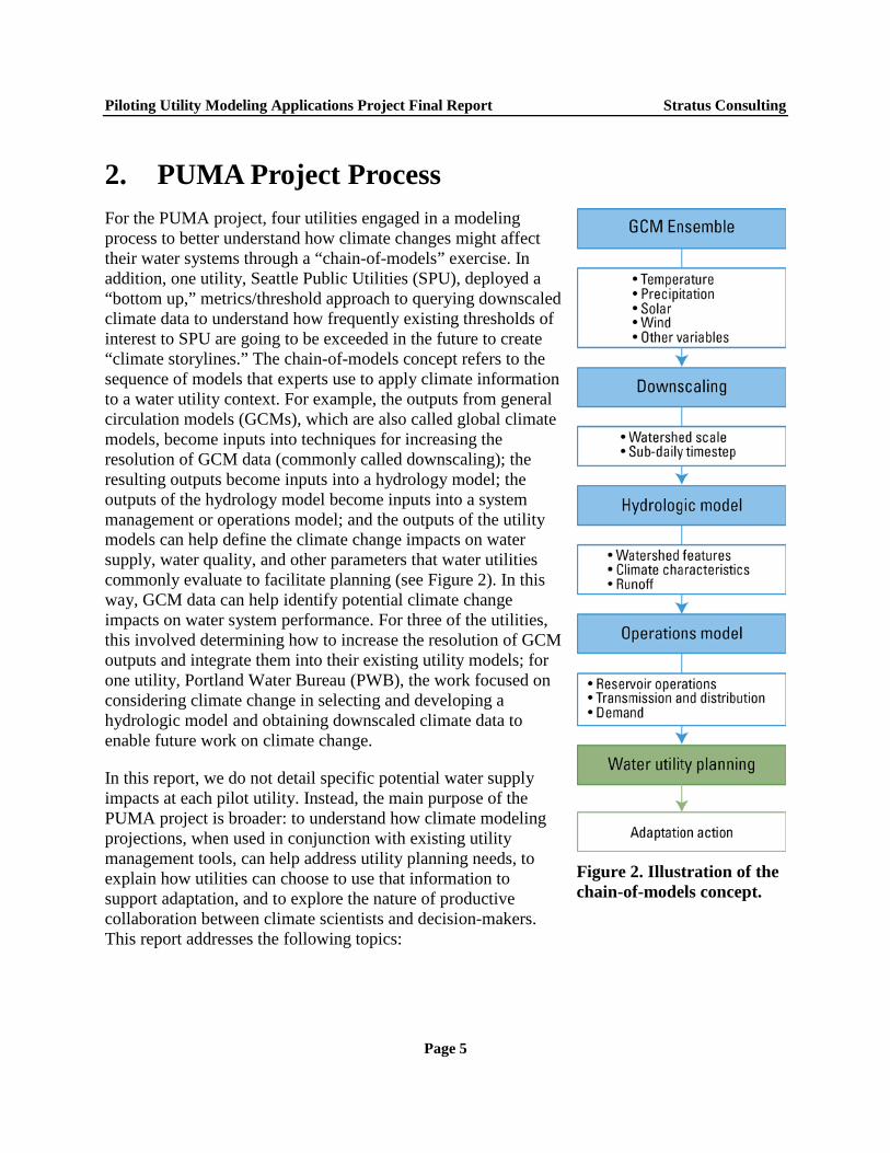
2. PUMA Project Process For the PUMA project, four utilities engaged in a modeling process to better understand how climate changes might affect their water systems through a “chain-of-models” exercise. In addition, one utility, Seattle Public Utilities (SPU), deployed a “bottom up,” metrics/threshold approach to querying downscaled climate data to understand how frequently existing thresholds of interest to SPU are going to be exceeded in the future to create “climate storylines.” The chain-of-models concept refers to the sequence of models that experts use to apply climate information to a water utility context. For example, the outputs from general circulation models (GCMs), which are also called global climate models, become inputs into techniques for increasing the resolution of GCM data (commonly called downscaling); the resulting outputs become inputs into a hydrology model; the outputs of the hydrology model become inputs into a system management or operations model; and the outputs of the utility models can help define the climate change impacts on water supply, water quality, and other parameters that water utilities commonly evaluate to facilitate planning (see Figure 2). In this way, GCM data can help identify potential climate change impacts on water system performance. For three of the utilities, this involved determining how to increase the resolution of GCM outputs and integrate them into their existing utility models; for one utility, Portland Water Bureau (PWB), the work focused on considering climate change in selecting and developing a hydrologic model and obtaining downscaled climate data to enable future work on climate change.
In this report, we do not detail specific potential water supply impacts at each pilot utility. Instead, the main purpose of the PUMA project is broader: to understand how climate modeling projections, when used in conjunction with existing utility management tools, can help address utility planning needs, to explain how utilities can choose to use that information to support adaptation, and to explore the nature of productive collaboration between climate scientists and decision-makers. This report addresses the following topics:
Figure 2. Illustration of the chain-of-models concept.
Page 5
Piloting Utility Modeling Applications Project Final Report Stratus Consulting
The climate modeling tools that the four utilities selected to obtain climate data and why, the climate modeling tools they did not select and why, and how the utilities obtained climate data to use in their assessments
Experiences in incorporating the data into hydrologic modeling tools to project impacts of climate change on water resources and resource management
The value of the results in decision-making and potential next steps
Lessons learned in the effort to bridge the gap between climate science providers and climate science users.
The utilities wanted to engage in this process in parallel with each other so they could share their experiences and learn from each other, so they could provide a roadmap for peer utilities that might consider engaging in a similar effort, and so interested scientists and climate service organizations could learn more about how to effectively translate climate science for adaptation planning purposes. The PUMA project has accomplished this to date by holding regular conference calls throughout the course of the project, including both utility and science leads for all four PUMA projects. To track their experience with this process, WUCA hired Stratus Consulting to act as an independent historian and observer of the process that unfolded at each utility over the subsequent 37 months. The Stratus Consulting team sent out a series of three or four surveys to each utility and engaged in a series of follow-up interviews with the PUMA teams to gather information about how each project evolved over time.
The remainder of this report profiles the experience of each utility’s PUMA project. This includes a brief project summary, several key issues of interest that arose in the project, and how the PUMA project is expected to affect utility decisions. These profiles are not intended to provide an exhaustive list of every issue that each utility addressed, but rather to call out some of the more interesting and insightful experiences of each utility. The report ends with Conclusions for an Applied Research Agenda for Climate Services, which draws on the lessons these four utilities learned and what those lessons mean for the coproduction of knowledge between climate modelers and water utilities.
For readers who may not yet be familiar with climate models and downscaling techniques, we recommend that you first turn to Appendix A, Applying Climate Model Outputs 101 for Water Utilities. This appendix provides a technical overview of the global climate modeling process, including discussions of model selection; reconciling large-scale versus local-scale climatic processes, commonly referred to as bias correction and downscaling; issues concerning time steps and time periods; and other topics. This basic discussion of the application of climate model outputs provides an adequate basis for understanding the context in which the four utilities made decisions during the course of the PUMA project.
Page 6
Piloting Utility Modeling Applications Project Final Report Stratus Consulting
3. PUMA Project Outcomes: Four Utility Project Profiles
The PUMA project leadership team selected four utilities to participate in the PUMA project, all with varying characteristics in areas such as previous experience assessing climate change, service area size, and primary climate change impact of concern. The four utilities selected were:
New York City Department of Environmental Protection (NYCDEP) Portland Water Bureau (PWB) Seattle Public Utilities (SPU) Tampa Bay Water (TBW).
Each of these utilities partnered with local scientific climate change experts, many of whom are part of the National Oceanic and Atmospheric Administration’s (NOAA’s) Regional Integrated Sciences and Assessments (RISA) program. Each science partner played a different role, but in general the science partners helped select, obtain data from, and better resolve the GCMs and GCM data, based on extensive discussion of each utility’s precise needs. The PUMA utilities and their scientific partners were:
NYCDEP – the City University of New York (CUNY) Institute for Sustainable Cities, Columbia University, the NASA Goddard Institute for Space Studies (NASA-GISS), Cornell University, and the Consortium for Climate Risk in the Urban Northeast (CCRUN)
PWB – the Pacific Northwest Climate Impacts Research Consortium (CIRC), which includes the University of Idaho (UID), the University of Washington (UW), and Oregon State University (OSU)
SPU – CIRC, which includes UID and OSU
TBW – the Southeast Climate Consortium (SECC), which includes the University of Florida (UF) and the Florida State University (FSU) Center for Ocean-Atmospheric Prediction Studies (COAPS).
Page 7
Piloting Utility Modeling Applications Project Final Report Stratus Consulting
3.1 New York City Department of Environmental Protection
NYCDEP overview Number of customers: 9.2 million Gallons of water produced per day: 1.1 billion Service types: Drinking water supply, wastewater and storm water management Supply sources: Mainly surface, with access to groundwater Water treatment: Not filtered (will be partially filtered once the Croton filtration facility is brought back online); treated with chlorine, ultraviolet light, phosphoric acid, sodium hydroxide, and fluoride; Alum is applied during high-turbidity events Primary concern for climate change: Water quality Project highlight: New York City created a new delta-change technique to increase the resolution of GCM data called the statistically distributed (SD)-delta method, which is simple to use yet provides insight on extreme events
3.1.1 NYCDEP’s PUMA project summary
NYCDEP’s PUMA project exemplifies a well-resourced and sophisticated utility that has explored complex scientific methods without choosing the most expensive or most complicated technique. Ultimately, NYCDEP used a relatively simple technique to increase the resolution of climate model data, using already developed hydrologic, reservoir water quality, and management models as a pragmatic way to start looking at climate change impacts. NYCDEP saw its PUMA project as part of an internally developed Climate Change Integrated Modeling Project that was already underway before the start of PUMA.
Through its PUMA project and preceding climate change work, NYCDEP has focused on identifying possible impacts and then developing operational policies to minimize the effects of those impacts. They were particularly concerned about impacts that would affect their supply, quality, and operations, such as changes in the timing of winter run-off, reduction in winter snowpack, changes in the thermal structure of reservoirs, and an increase in the severity of extreme events.
Although NYCDEP’s climate change work has generated useful insights on changes in winter precipitation and peak runoff, the utility believes these water supply issues are manageable. NYCDEP’s more challenging concern lies in water-quality issues, such as high turbidity driven by extreme precipitation. NYCDEP has found in its PUMA-related work that examining the effects of extreme precipitation events on water quality under climate change is particularly challenging because current climate models provide only limited information on this topic.
Page 8
Piloting Utility Modeling Applications Project Final Report Stratus Consulting
3.1.2 NYCDEP issues of interest
NYCDEP issue 1: Selecting GCMs
The process by which NYCDEP decided on which GCM data to use is instructive. The New York City PUMA team members initially selected four GCMs3 for which they could easily access model output online. The team members evaluated each model’s fit for their region by using a probability-based skill score comparing baseline GCM outputs with historical data. However, after analyzing the data from the four models, they discovered that one model had the best fit for temperature while a different model had the best fit for precipitation. Thus, they could not find one best model.
This led NYCDEP to shift their strategy and pull data from a larger suite of GCMs. This time, team members first considered which models provided data for the variables needed to run their existing management models. Variables included air temperature (average, maximum, and minimum), precipitation, solar radiation, and wind speed, all at daily time steps. Based on these needs, NYCDEP was able to select a subset of 15 to 20 Coupled Model Intercomparison Project Phase 3 (CMIP3) GCMs from which to pull data for its analysis. At this point, NYCDEP needed to convert GCM output to higher resolution to compare it against historical station data.
NYCDEP issue 2: Developing future climate scenarios
NYCDEP selected the delta-change method4 to develop future climate scenarios from GCM output. These GCM scenarios provided a daily time series of derived meteorological variables that served as the driving data behind the hydrologic and water quality models. The major advantage of the delta-change method was the ease and speed of application, and the direct scaling of local historical observations to form a scenario based on changes suggested by the GCM simulations. One disadvantage to this approach was that the temporal sequencing of storm events in the derived time series remained unchanged from the historical record; this method may not be helpful in circumstances where changes in event frequency and antecedent conditions are important to the impact assessment.
However, NYCDEP felt more confident using historical events, altering the events’ magnitude as a foundation for hypothetical future events. This approach empowered utility staff to apply their own institutional knowledge of past events when considering climate change, and enabled NYCDEP to develop hypothetical droughts or storms. The utility could then ask broad questions
3. CCGCM, GISS, CCSM3, and ECHAM5/MPI-OM.
4. In the delta-change method, an additive (or in the case of precipitation, multiplicative) change factor is calculated as the difference (or in the case of precipitation, the ratio) between a GCM variable derived from a current climate simulation (“GCM baseline”) and derived from a future climate scenario (“GCM future”) taken at the same GCM grid location.
Page 9
Piloting Utility Modeling Applications Project Final Report Stratus Consulting
such as, “What if the drought of the 1960s happened again, but was more intense because of climate change? If New York experienced a hurricane followed by a tropical storm, as it did in 2011, how would this type of event be different under an altered future climate?”
NYCDEP issue 3: Addressing water quality issues caused by extreme events
NYCDEP was motivated in large part by the potential impacts of climate change on water quality, especially by causing high turbidity in NYCDEP’s unfiltered water supply. Turbidity must remain below a certain level to maintain the utility’s Filtration Avoidance Determination. Other water quality issues, such as climate impacts on disinfection byproducts and dissolved organic carbon, also motivated NYCDEP. All of these water-quality impacts are generally driven by extreme events, such as intense rain events or extended periods of very high temperatures. Notably, such extreme events can also affect operations and damage infrastructure, and, according to NYCDEP, were worth understanding for those reasons as well.
Currently, climate scientists provide many extreme event projections in qualitative terms because GCMs cannot sufficiently capture quantitative changes in extreme events. For example, the intensity of hurricanes is expected to increase because more energy will be available from warmer sea surface temperatures. However, GCMs cannot currently quantify such increases in intensity precisely.
NYCDEP considered these qualitative statements regarding changes in extremes useful from a planning perspective, but not useful in a chain-of-models analysis, which requires numeric inputs. This led NYCDEP to develop a method that could be used in a chain-of-models analysis that also represented extreme events – a SD-delta method:
In the SD-delta method, modelers derive multiple change factors for each month across the cumulative distribution functions (CDFs) of daily meteorology values from hindcasts and projections from GCMs. Examples of meteorology values are total daily precipitation and maximum air temperature.
To derive the series of change factors, the CDF is divided into a series of bins of daily meteorology values, with a change factor calculated specifically for each bin. The method can be adapted for bins of any size.
To develop a climate-altered time series for a meteorological variable, these monthly change factors are then applied to observed data for the location of interest. When the change factors for the bins at the tails of the CDF are used, this provides information about extreme events.
Page 10
Piloting Utility Modeling Applications Project Final Report Stratus Consulting
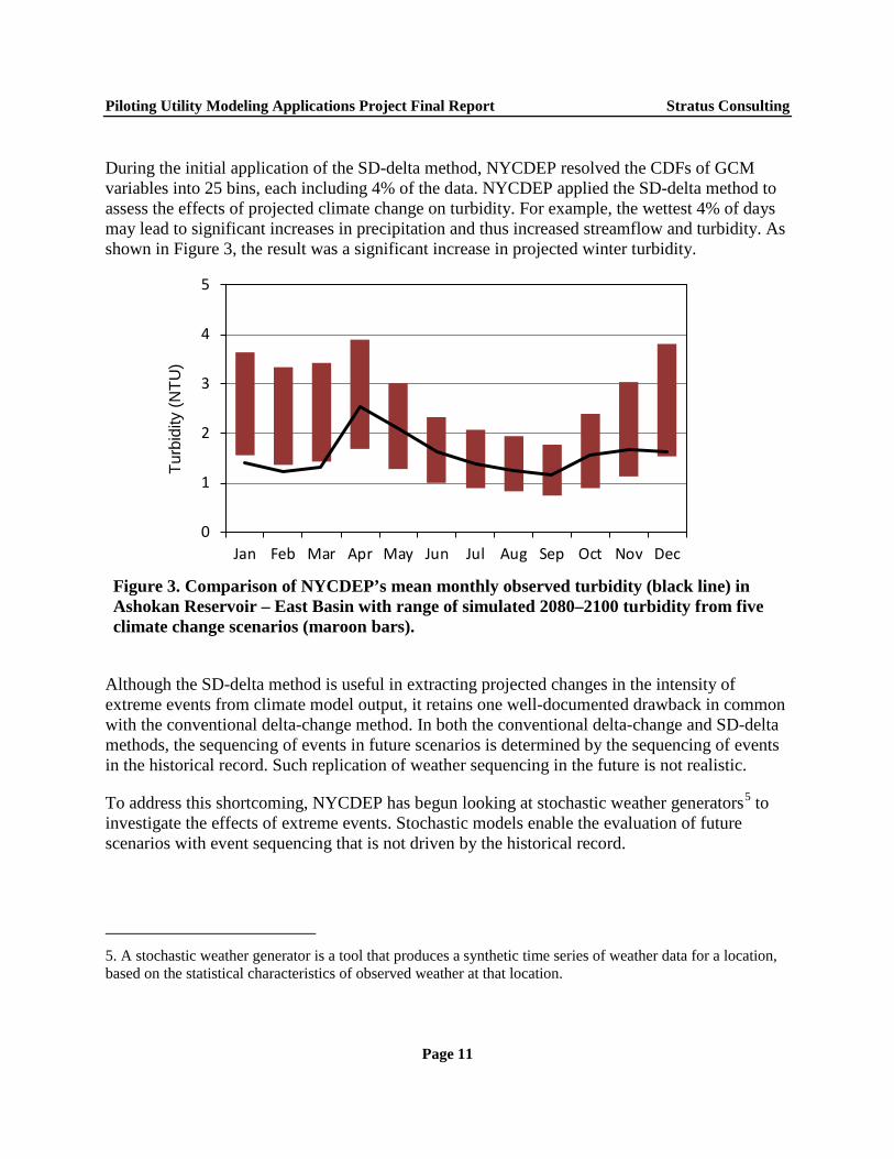
During the initial application of the SD-delta method, NYCDEP resolved the CDFs of GCM variables into 25 bins, each including 4% of the data. NYCDEP applied the SD-delta method to assess the effects of projected climate change on turbidity. For example, the wettest 4% of days may lead to significant increases in precipitation and thus increased streamflow and turbidity. As shown in Figure 3, the result was a significant increase in projected winter turbidity.
Figure 3. Comparison of NYCDEP’s mean monthly observed turbidity (black line) in Ashokan Reservoir – East Basin with range of simulated 2080–2100 turbidity from five climate change scenarios (maroon bars).
Although the SD-delta method is useful in extracting projected changes in the intensity of extreme events from climate model output, it retains one well-documented drawback in common with the conventional delta-change method. In both the conventional delta-change and SD-delta methods, the sequencing of events in future scenarios is determined by the sequencing of events in the historical record. Such replication of weather sequencing in the future is not realistic.
To address this shortcoming, NYCDEP has begun looking at stochastic weather generators5 to investigate the effects of extreme events. Stochastic models enable the evaluation of future scenarios with event sequencing that is not driven by the historical record.
5. A stochastic weather generator is a tool that produces a synthetic time series of weather data for a location, based on the statistical characteristics of observed weather at that location.
0
1
2
3
4
5
Jan Feb Mar Apr May Jun Jul Aug Sep Oct Nov Dec
Turb
idity
(NTU
)
Page 11
Piloting Utility Modeling Applications Project Final Report Stratus Consulting
NYCDEP issue 4: Bringing scientific expertise in house
NYCDEP has a rich history of diverse partnerships with external climate scientists and experts. Starting in 2003, NYCDEP’s Bureau of Environmental Planning and Analysis created a Climate Change Task Force that consisted of members within NYCDEP as well as outside participants, such as climate and impact scientists from Columbia University; an environmental engineering consulting firm, HydroQual; and the New York City Office of Environmental Coordination, the Office of Long-term Planning and Sustainability, and the Law Department. The task force conducted an adaptation assessment that was published in 2008.
More recently, NYCDEP has partnered with scientists at Cornell University and it also continues to work collaboratively with the local RISA,6 the CCRUN, on a number of collaborative projects. Most notably, however, NYCDEP has developed an extensive internal network of scientific capacity. In a unique partnership, the City University of New York (CUNY) Institute for Sustainable Cities hires full-time post-doctoral scientists to work with NYCDEP staff at NYCDEP offices. NYCDEP scientists, along with faculty from various support universities who serve as part-time project advisors, then closely oversee the work of the post-doctoral scientists. The program has allowed NYCDEP to maintain a broader and more continuous scope in its climate change work and provides a mechanism for technology and knowledge transfer from scientists with state-of-the-art expertise to NYCDEP staff scientists. Although post-doctoral scientist turnover can be problematic, NYCDEP staff judge this program as a major success and as value-added to its climate impacts work.
3.1.3 How the PUMA project will affect utility decisions
The climate change team members at NYCDEP are optimistic that their findings from the PUMA project will influence decision-making both within and outside their utility. Within NYCDEP, where possible, the team proactively encouraged climate change considerations. For instance, they started voluntarily and proactively including the results of their research in a report capturing progress on source water protection to maintain the U.S. Environmental Protection Agency’s Filtration Avoidance Determination. In recent years, the NYCDEP climate change team noticed an increase in questions about climate change impacts from within the utility. Superstorm Sandy, Tropical Storms Irene and Lee, and other extreme events in the area, such as the 2007 floods in New York City, have contributed to the increased discussion around climate change impacts. These extreme events have heightened interest about climate change concerns at the highest levels within NYCDEP and increased support of climate change research within the utility. However, because many of NYCDEP’s ongoing modeling results still involve a fair
6. NOAA’s RISA program supports research teams that help expand and build the nation’s capacity to prepare for and adapt to climate variability and change. RISA is explicitly charged with collaborating and partnering with public and private climate data user communities.
Page 12
Piloting Utility Modeling Applications Project Final Report Stratus Consulting
amount of uncertainty, it is not yet undertaking any large, climate-specific operational or management decisions for water supply based on these results, but is instead engaging in a no-regrets strategy as described in the box below.7
Decision-makers at NYCDEP have also started to get questions from outside the organization regarding climate change. They have participated in region-wide post-Sandy meetings about how climate change could affect regulatory decisions to increase preparedness for similar types of extreme events in the future. These meetings have created opportunities to leverage the results from their PUMA project and other climate change research directly into the decision-making process both within and outside the utility.
NYCDEP’s climate change modeling work allowed the team to have answers ready for internal and external inquires, and reinforced the climate change team’s emphasis on no-regrets adaptation planning when possible (see the text box, Example of a no-regrets strategy in NYCDEP).
Example of a no-regrets strategy in NYCDEP
No-regrets strategies are those that provide benefits under current climate conditions and potential future climate conditions. When a utility spends money on a no-regrets strategy, it will reduce the utility’s risk to existing utility stressors while making it more resilient to future climate change, ensuring the investment is worthwhile regardless of which climate future unfolds. For example, a main focus within NYCDEP over the past five to six years has been to invest in increasing its ability to blend water. Blending means combining water from various sources to meet water quality requirements. To expand its ability to blend water, NYCDEP has built a better operations modeling system and embarked on infrastructure projects such as connecting aqueducts that expand their capacity to draw and mix water from multiple sources. These approaches help provide NYCDEP with a greater flexibility to address a multitude of current and future challenges to its system, including the impacts of climate change. When NYCDEP climate change team members present information to their decision-makers, they encourage no-regrets strategies when possible.
7. Note that NYCDEP has already undertaken major projects to protect wastewater facilities from storm surge and sea level rise, where the direction of change is clearer and the need more immediate.
Page 13
Piloting Utility Modeling Applications Project Final Report Stratus Consulting
3.2 Portland Water Bureau
PWB overview
Number of customers: 935,000
Gallons of water produced per day: 101 million
Service type: Drinking water supply
Supply sources: Surface and groundwater
Water treatment: Not filtered; treated with chloramine
Primary concern for climate change: Shifts in the hydrograph for the primary surface water supply that could affect the timing and length of reservoir drawdown and changes in extreme precipitation events that could affect turbidity; both of these could influence use of the secondary groundwater supply
Project highlight: PWB evaluated a range of hydrology models against its needs and selected one within budget that can integrate climate modeling data for long-term planning purposes
3.2.1 PWB’s PUMA project summary
PWB first examined potential climate change impacts to its primary surface water supply, the Bull Run watershed, through a 2001 study. In the PUMA project, the utility wanted to evaluate results from the newer generation of climate models to see what, if anything, had changed. Although its overall goal was similar to other utilities, the PWB team was able to approach the work from a unique perspective. Because the utility did not yet have an existing in-house hydrologic model, PWB was in a better position to begin its discussions with a focus on outcomes, without worrying about process or sunken costs in an existing utility hydrologic model.
PWB’s team members decided they wanted to focus their PUMA research on a long-term evaluation of the impacts of climate change on the Bull Run watershed. With this objective in mind, the members set out to select a hydrologic model that would best fit their needs, and which could be used to translate GCM outputs, such as temperature and precipitation, into future stream flow projections that could inform long-term planning.
PWB has never used a hydrologic model to conduct day-to-day operations, and has instead relied on internal modeling tools for operational purposes. However, PWB needed a hydrologic model for its climate impacts assessment. At first, PWB considered implementing the same hydrologic model as a peer utility, but that hydrologic model was expensive and complicated to use because it was designed for operational purposes. PWB team members decided that they did not need to invest in a complex hydrologic model designed to support operations to investigate the impacts of climate change on their watershed. However, they decided the ability to investigate climate
Page 14
Piloting Utility Modeling Applications Project Final Report Stratus Consulting
change impacts was worth the investment in a relatively inexpensive and easy-to-use hydrologic model customized for the Bull Run watershed. Their model review revealed that they would be able to obtain answers to their research questions without investing in an expensive hydrologic model.
3.2.2 PWB issues of interest
PWB issue 1: Selecting a hydrologic model
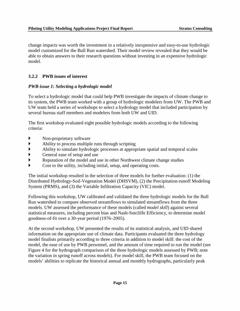
To select a hydrologic model that could help PWB investigate the impacts of climate change to its system, the PWB team worked with a group of hydrologic modelers from UW. The PWB and UW team held a series of workshops to select a hydrology model that included participation by several bureau staff members and modelers from both UW and UID.
The first workshop evaluated eight possible hydrologic models according to the following criteria:
Non-proprietary software Ability to process multiple runs through scripting Ability to simulate hydrologic processes at appropriate spatial and temporal scales General ease of setup and use Reputation of the model and use in other Northwest climate change studies Cost to the utility, including initial, setup, and operating costs.
The initial workshop resulted in the selection of three models for further evaluation: (1) the Distributed Hydrology-Soil-Vegetation Model (DHSVM), (2) the Precipitation-runoff Modeling System (PRMS), and (3) the Variable Infiltration Capacity (VIC) model.
Following this workshop, UW calibrated and validated the three hydrologic models for the Bull Run watershed to compare observed streamflows to simulated streamflows from the three models. UW assessed the performance of these models (called model skill) against several statistical measures, including percent bias and Nash-Sutcliffe Efficiency, to determine model goodness-of-fit over a 30-year period (1976–2005).
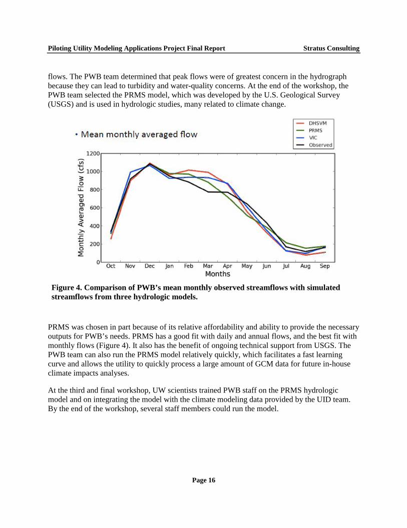
At the second workshop, UW presented the results of its statistical analysis, and UID shared information on the appropriate use of climate data. Participants evaluated the three hydrology model finalists primarily according to three criteria in addition to model skill: the cost of the model, the ease of use by PWB personnel, and the amount of time required to run the model (see Figure 4 for the hydrograph comparison of the three hydrologic models assessed by PWB; note the variation in spring runoff across models). For model skill, the PWB team focused on the models’ abilities to replicate the historical annual and monthly hydrographs, particularly peak
Page 15
Piloting Utility Modeling Applications Project Final Report Stratus Consulting
flows. The PWB team determined that peak flows were of greatest concern in the hydrograph because they can lead to turbidity and water-quality concerns. At the end of the workshop, the PWB team selected the PRMS model, which was developed by the U.S. Geological Survey (USGS) and is used in hydrologic studies, many related to climate change.
Figure 4. Comparison of PWB’s mean monthly observed streamflows with simulated streamflows from three hydrologic models.
PRMS was chosen in part because of its relative affordability and ability to provide the necessary outputs for PWB’s needs. PRMS has a good fit with daily and annual flows, and the best fit with monthly flows (Figure 4). It also has the benefit of ongoing technical support from USGS. The PWB team can also run the PRMS model relatively quickly, which facilitates a fast learning curve and allows the utility to quickly process a large amount of GCM data for future in-house climate impacts analyses.
At the third and final workshop, UW scientists trained PWB staff on the PRMS hydrologic model and on integrating the model with the climate modeling data provided by the UID team. By the end of the workshop, several staff members could run the model.
Page 16
Piloting Utility Modeling Applications Project Final Report Stratus Consulting
PWB issue 2: Difficulties developing a hydrologic dataset
To set up and run the PRMS model, the PWB team used regional topography, soil, and vegetation data from geographic information system (GIS) datasets. However, because PWB has only one meteorological station in the watershed, the UW team recommended the use of a historical gridded meteorological dataset (Livneh et al., 2013) to calibrate the model against historical stream flows for the watershed. One meteorological station would not capture the topographic climate gradients within the entire watershed, especially as they relate to air temperature and the amount and phase of precipitation (i.e., snow or rain). The Livneh et al. dataset is at a 6-kilometer resolution and is the most current dataset available for the coterminous United States. It is an update to the widely used Maurer et al. (2007) dataset, and applies the same methodology. It uses 1915–2011 historical climatology data from NOAA’s Cooperative Observer Program, as well as data from the Parameter-elevation Relationships on Independent Slopes Model (PRISM).
The PRMS model calibration initially showed persistent differences in average monthly flows between PRMS and the historical data. These differences were because of bias in the Livneh et al. dataset, not because of problems with the PRMS model. While the Livneh et al. dataset is a robust dataset, its resolution did not capture the micro-climate and orographic effects8 present in the Bull Run watershed, which is located on the flank of Mount Hood and near the Columbia River Gorge. Specifically, the dataset did not accurately represent the water balance of the watershed, in terms of amount of precipitation, evapotranspiration, and runoff. Consequently, the UW team needed to bias-correct9 the Livneh et al. dataset to fit historical conditions in PWB’s watershed, mainly by increasing average monthly precipitation.
The initial calibration of PRMS thus required more effort than expected, in large part because good historical data, at the scale required for the watershed, were not readily available. These historical data had to be developed and bias corrected, as described above, to enable further climate-impact studies. With the bias correction to the Livneh et al. dataset accomplished, the PWB team could compare historical stream flows from the hydrologic model with observed streamflows and fine-tune the model to ensure the best fit. With this task completed, the PWB team is now able to run downscaled temperature and precipitation data from the GCMs through the PRMS model.
8. An orographic effect is a change in atmospheric conditions (e.g., humidity, precipitation, wind speed) caused by a change in elevation, typically related to mountain ranges.
9. Note that this type of bias correction is not referring to the climate models, but to correcting historical data for the hydrologic model.
Page 17
Piloting Utility Modeling Applications Project Final Report Stratus Consulting
PWB issue 3: Selecting GCMs and increasing data resolution
While PWB staff did not spend time experimenting with GCM data during the PUMA project, they did work with climate modelers at UID to develop downscaled GCM data for their use. At first, UID provided PWB with a subset of five GCMs that were representative of the multi-model mean and extremes, for use if PWB did not have the resources to run more GCMs.
However, given the characteristics of the selected PRMS hydrologic model, the PWB team decided to use all available downscaled GCMs provided by UID as inputs into PRMS to develop climate-altered hydrologies for future time periods. The main reason for this is that several climate scientists involved in this project, including Dr. Phil Mote with the CIRC (also the PUMA science and climate service lead since the outset of the project), advocated for the use of at least 10 GCMs to capture the range of uncertainty in future climate offered by current climate models.
The UID team chose a 20-model subset of the 41 Coupled Model Intercomparison Project Phase 5 (CMIP5) models because they provide daily climate data for the following variables: minimum temperature, maximum temperature, precipitation, downwelling shortwave radiation, specific humidity, maximum relative humidity, minimum relative humidity, and surface wind components. These variables were necessary for the UID team to downscale the GCMs using the Multivariate Adaptive Constructed Analog (MACA) method. Not all GCMs provide these variables at a daily time step. The MACA datasets include historical (1950–2005) and future (2006–2100) time periods. Furthermore, an important component of the MACA process was the use of the bias-corrected Livneh et al. dataset in “training” the GCMs during downscaling. Normally, MACA uses a 4-kilometer resolution historical training dataset for the GCMs. However, in this case, because UW had essentially customized the Livneh et al. dataset to 6-kilometers for the Bull Run watershed, the UID team felt that using this dataset to train the GCMs would lead to more location-specific downscaled data.10
UID also provided PWB with a ranking of the original, non-downscaled, 20 GCMs based on how well they represented the historical climate record for the Northwest. This information will be useful to PWB as it conducts its in-house analysis; it will be a way to quality check the downscaled data. If some downscaled datasets do not result in a good historical fit with observed streamflows, it may be because the relevant GCM has a low ranking in terms of fit to historical climate in the Northwest.
10. Note that PWB and SPU used the same statically downscaled datasets (MACA and Livneh et al.), but customized each differently based on their different watershed context and hydrologic modeling systems. Due to overlap in the researchers working on both the PWB and SPU projects, both utilities received consistent datasets, which allows them to share results with each other with some degree of comparability.
Page 18
Piloting Utility Modeling Applications Project Final Report Stratus Consulting
PWB issue 4: Developing in-house capacity
From the beginning, PWB was motivated to build institutional capacity through their PUMA project. Partly because PWB was unable to update the results of their 2001 climate impacts study internally, utility personnel decided that they should use the PUMA project as an opportunity to develop their technical in-house expertise and capability to do future climate impacts analyses, instead of relying on consultants and climate scientists alone. This required not only selecting a hydrologic model that was easy to use, but also training personnel in the use of that hydrologic model and in climate impacts analysis.
Through this experience, PWB came to several realizations about the interplay between climate science and water utility experts. First, the PWB team found it necessary to simplify some of the statistical and technical information that the climate scientists provided to solicit input from other utility staff who were not as familiar with climate or hydrologic models. PWB also learned that educating climate scientists about the qualities and operation of the PWB water system was necessary to help the scientists generate applicable hydrologic and climate inputs. A key lesson for PWB was not to assume that climate scientists understand water utility operations and modeling environments.
3.2.3 How the PUMA project will affect utility decisions
The main objective of PWB’s PUMA project was to select a hydrologic model that could help the utility with future climate change impacts research. With a hydrologic model selected and GCMs identified, downscaled, and refined, PWB plans to continue its climate assessment work by running the outputs from the full suite of 20 GCMs through the PRMS model.
Going forward, PWB team members will focus on understanding how they might portray and use the model results in the future, including how to integrate the results into PWB’s long-range planning processes. Additionally, the City of Portland has completed a Climate Change Preparation Strategy, which includes actions that PWB will take to help prepare for the impacts of climate change. Results from this project could inform the update to this strategy in future years.
Page 19
Piloting Utility Modeling Applications Project Final Report Stratus Consulting
3.3 Seattle Public Utilities
SPU overview
Number of customers: 1.3 million
Gallons of water produced per day: 120 million
Service types: Drinking water supply; wastewater, solid waste, and storm water management
Supply sources: Surface and groundwater for peak season and emergency use
Water treatment: SPU’s largest water source, the Cedar watershed, is unfiltered and all water is treated with chlorine, ozone, and ultraviolet light; SPU’s second surface water source, the Tolt watershed, is filtered and treated with ozone and chlorine. Both sources provide for corrosion control and fluoridation.
Primary concern for climate change: Impacts of climate change on water availability/reliability, impacts of climate change on conditions of operational interest to SPU (e.g., number of days with precipitation greater than 2 inches), timing of the onset of fall rains and the effects on reservoir refill strategies, atmospheric rivers (corridors of moisture in the atmosphere) and their effects on flooding, and possible increases in forest fire incidence or intensity on protected watersheds.
Project highlight: SPU is using the chain-of-models approach for assessing impacts on supply through a co-production model, and is generating the climate-altered hydrology and water supply impacts assessment in-house. It is complementing this with a “bottom-up” approach using SPU-specific metrics to query the downscaled climate projections and generate “climate storylines” that have operational implications for SPU and that help to describe projected changes in the climate. SPU was still completing its analysis as this report went to press; this summary is preliminary and subject to change.
3.3.1 SPU’s PUMA project summary
SPU has conducted three climate impact assessments of its water supply, with the most recent one completed in 2008. The utility decided to use its PUMA project as an opportunity to update this 2008 study11 by using CMIP5 climate model outputs, increasing the sophistication of its analysis by increasing the number of climate models considered and by “rounding out” the traditional focus on water supply to examine other, complementary research questions. The utility also viewed the project as an opportunity to build institutional capacity by assuming the responsibility of generating climate-altered hydrologies in-house using downscaled meteorological data, as well as the water supply impacts analysis. SPU was particularly interested in four questions:
11. The previous 2008 SPU study used three GCMs and two emissions scenarios. The spatial resolution of that data was increased by using a delta-change technique with quantile mapping applied to the historical meteorological record. Furthermore, the mapping (i.e., transformation functions) were not uniform across a grid cell and were different for each meteorological station.
Page 20
Piloting Utility Modeling Applications Project Final Report Stratus Consulting
1. How might climate change affect long-term water supply availability or reliability?
2. How will climate change affect some baseline conditions of operational interest to SPU?
3. What effect will climate change have on the timing of the onset of fall rains and on atmospheric rivers?
4. How might climate change affect forest fire frequency and intensity?
SPU’s PUMA project amounted to a sophisticated chain-of-models approach complemented by a bottom-up analysis of the downscaled meteorological data, GCM outputs, and literature review.
In addition, two issues SPU wanted to explore through the PUMA project were the effect, if any, that climate change would have on the timing of the return of fall rains and on the advent of atmospheric rivers. These two phenomena are of operational and long-term planning interest to SPU:
SPU has a relatively small storage capacity in its two reservoirs compared to other water systems, which may have multi-year storage. As a result, SPU largely depends upon an annual refill cycle that is initiated by the return of fall rains. A delay in the fall rains could pose some challenges for SPU.
Atmospheric rivers have a dual nature from SPU’s perspective. The sustained, large volumes of precipitation they generate can create challenges for SPU’s drainage, wastewater, and drinking water systems. However, atmospheric rivers can also play a “drought buster” role, providing much-needed precipitation in the midst of a dry period. In the winter of 2014, SPU witnessed this second quality: a series of four minor atmospheric rivers arrived in Washington State just as the state was contemplating declaring a drought. The storms increased SPU’s supply/snowpack roughly twofold in approximately four weeks.
3.3.2 SPU issues of interest
SPU issue 1: Using an operational metric/threshold approach
With their PUMA project, SPU decided to complement the top-down chain-of-models approach with a bottom-up approach in which the utility identified operational metrics/thresholds of relevance and those to query the downscaled projections. For example, SPU identified a 24-hour, 2-inch precipitation event as a metric for long-duration events that generally cause problems for its drainage and wastewater system. The utility also identified multiple consecutive days over 80°F with no precipitation as a metric of conditions that raise concerns about possible forest
Page 21
Piloting Utility Modeling Applications Project Final Report Stratus Consulting
fires. Nearly 30 metrics were developed, some of which were developed in consultation with other city departments, such as Seattle City Light and the Department of Transportation.
The metric/threshold approach helped make the climate projections utility-specific, defining variables of concern to monitor over time. This approach may make climate projections more relevant by placing them in the context of how climate change may exacerbate current vulnerabilities. Finally, SPU thought that the use of operational metrics/thresholds could help develop “climate storylines” (i.e., descriptions of how current conditions of interest to SPU are expected to change in the future). The utility felt that the storylines would be a nice complement to the chain-of-models analysis and facilitate communication about the potential effects of climate change on its systems and services.
SPU issue 2: Challenges in disaggregating daily data
SPU’s hydrology model HFAM requires hourly data to run, but the MACA-downscaled GCM data the utility was using were recorded as daily values. As a consequence, the SPU team used the HFAM guidelines on temporal disaggregation of daily data. When hourly data were missing, these guidelines call for allocating the daily precipitation amount equally across the 5 hours between 4:00 a.m. and 9:00 a.m., with the remaining 19 hourly precipitation values set to zero.
Unfortunately, following these guidelines led to significant discrepancies between observed and simulated monthly average stream flows. The total annual stream flow was similar. However, compared to observations the simulation showed less runoff during the early winter months and more runoff during the spring. The entire hydrograph was incorrect in both magnitude and timing.
The SPU-CIRC team traced this problem to the method of temporal disaggregation. Because the 4:00 a.m. to 9:00 a.m. period is a particularly cold time of day, choosing that five-hour period to evenly spread the daily precipitation amount resulted in a bias of too much snow accumulation in the winter. SPU’s watersheds are in a transition zone, where temperatures regularly cross the freezing point. The arbitrary precipitation allocation over-predicted precipitation falling as snow and under-predicted precipitation falling as rain in the winter; this led to predictions of lower winter flows, more snow available to melt during the spring, and higher spring flows.
SPU plans to resolve this problem by selecting a different temporal disaggregation of precipitation (e.g., allocating daily precipitation during a warmer time of the day and choosing the five-hour period that minimizes the error in the hydrograph). CIRC’s sensitivity analysis identified the 7:00 a.m.–12:00 p.m. window as the one that minimizes the error and yields the most realistic hydrograph. SPU may explore other methods of temporal disaggregation in future assessments, after the PUMA project. Although the discrepancy initially caused concern, joint investigations into the discrepancy illustrated the benefits of co-production and co-learning, as well as the importance of testing the projections and assumptions.
Page 22
Piloting Utility Modeling Applications Project Final Report Stratus Consulting
SPU issue 3: Developing institutional capacity
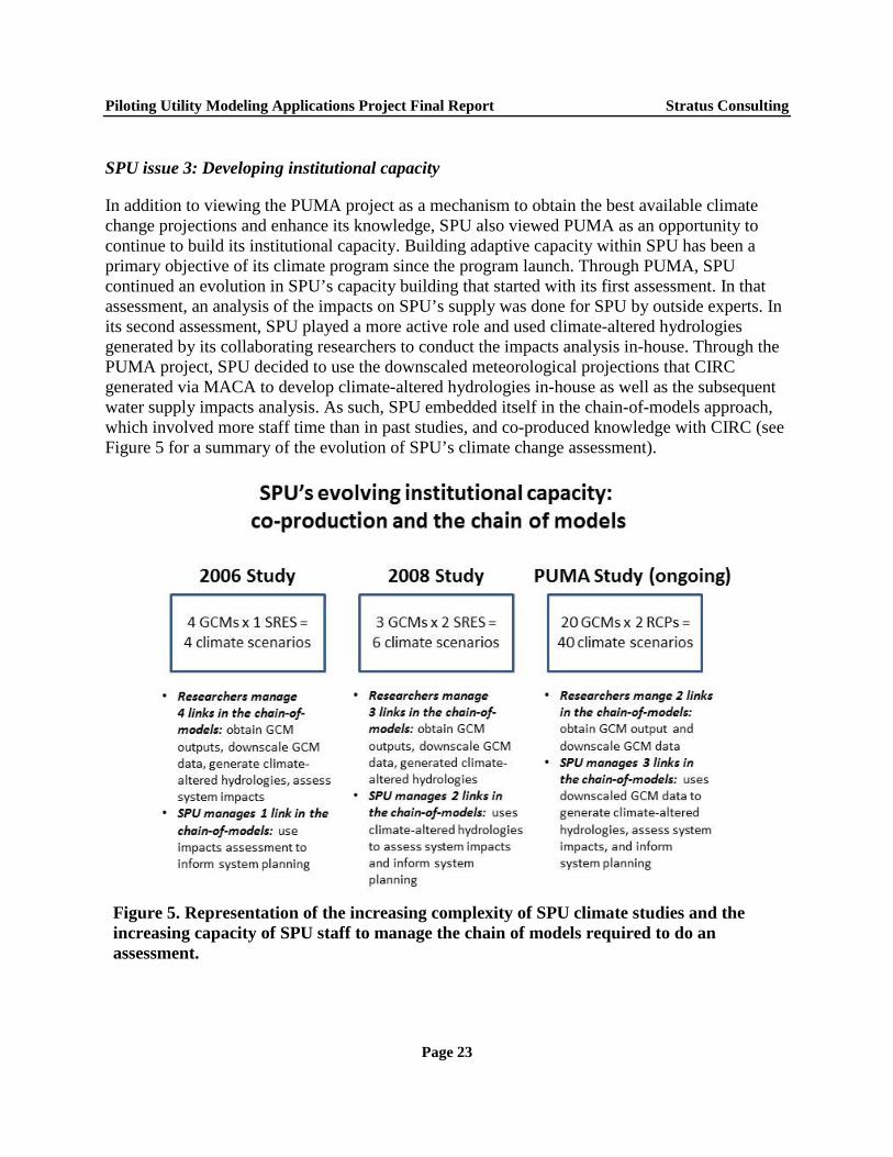
In addition to viewing the PUMA project as a mechanism to obtain the best available climate change projections and enhance its knowledge, SPU also viewed PUMA as an opportunity to continue to build its institutional capacity. Building adaptive capacity within SPU has been a primary objective of its climate program since the program launch. Through PUMA, SPU continued an evolution in SPU’s capacity building that started with its first assessment. In that assessment, an analysis of the impacts on SPU’s supply was done for SPU by outside experts. In its second assessment, SPU played a more active role and used climate-altered hydrologies generated by its collaborating researchers to conduct the impacts analysis in-house. Through the PUMA project, SPU decided to use the downscaled meteorological projections that CIRC generated via MACA to develop climate-altered hydrologies in-house as well as the subsequent water supply impacts analysis. As such, SPU embedded itself in the chain-of-models approach, which involved more staff time than in past studies, and co-produced knowledge with CIRC (see Figure 5 for a summary of the evolution of SPU’s climate change assessment).
Figure 5. Representation of the increasing complexity of SPU climate studies and the increasing capacity of SPU staff to manage the chain of models required to do an assessment.
Page 23
Piloting Utility Modeling Applications Project Final Report Stratus Consulting
3.3.3 How the PUMA project will affect utility decisions
SPU is a leader in integrating climate change science into utility planning. The utility has one full-time staff person in the Director’s Office in charge of the Climate Resiliency Group within the organization. However, despite the strong support for the issue within SPU, incorporating climate into its planning and decision-making is still an operational challenge. Big hurdles exist in integrating climate change into SPU’s line of businesses and bridging the gap between information generated through assessments and information needed to inform decisions. Fundamentally, this effort to mainstream climate change into current practices raises important issues about appropriate uses of climate projections. It also brings to light the need to adjust existing decision-making frameworks to better address the uncertainties and projected impacts of climate change.
Some of the concrete ways in which SPU integrates and shares climate change information within its organization include:
Stage Gates: Stage Gates is SPU’s asset-management governance process in which SPU managers make decisions at specified points (e.g., Stage Gates) in the project conception and delivery cycle before the project can advance to the next phase or stage. The process now includes high-level climate questions to ensure that project managers consider changes to climate in their project evaluations. The PUMA products may be useful for considering climate impacts with Stage Gates decisions.
Science Talks: SPU holds Science Talks that are open to all SPU staff. These talks constitute a forum to present the latest climate change information and discuss how it can be integrated into employees’ work. These talks represent a way to share information and gain buy-in from other staff.
Strategic Business Plan/Water System Plans: SPU just adopted a six-year strategic business plan that prominently features climate change. SPU has also used its state-mandated Water System Plan as a venue to include climate change impact assessments on long-range water supply plans.
Climate College: SPU is considering starting a series of trainings for utility personnel concerning different climate-related topics. If this training comes to fruition, it would be another venue at which the PUMA team could present their findings.
Results of the research on these two phenomena was not available at the time this report was completed, but SPU intends to share the results as appropriate when they become available and to integrate that information into utility decisions.
Page 24
Piloting Utility Modeling Applications Project Final Report Stratus Consulting
3.4 Tampa Bay Water
TBW overview
Number of customers: 2.3 million
Gallons produced per day: 220–260 million
Types of service: Drinking water supply
Supply sources: Surface, groundwater, desalination
Water treatment: Monochloramines disinfection, pH control for groundwater; filtration/ozone/ monochloramines disinfection for surface water; surface water pretreatment and membrane reverse osmosis for seawater desalination; all treated waters are blended and disinfected with monochloramines
Primary concern for climate change: Changes in seasonal rainfall patterns both temporally and spatially at the daily time scale
Project highlight: After conducting a thorough comparative analysis of several techniques for increasing the resolution of GCM data, TBW developed a new method that captured the spatial-temporal relationships of rainfall that drive west-central Florida’s hydrology
3.4.1 TBW’s PUMA project summary
TBW started considering climate change impacts to its utility before the PUMA project. They saw the PUMA project as an opportunity to continue its strong partnership with the UF Water Institute and the SECC. TBW’s goals for the PUMA project were twofold: (1) to increase the relevance of climate, climate change data, and tools to planning and operating Florida public water supply utilities in general, and TBW in particular; and (2) to develop collaborative relationships with climate scientists and hydrologists in academia and NOAA’s climate services to promote development and availability of usable climate data for hydrologic modeling.
TBW did not have an immediate need for climate information developed through its PUMA project, which allowed the utility to take a more exploratory and deliberative approach to its project. The TBW team decided to use the project to explore several modeling options and decide on the best methodology, so that when a major decision needs to be considered using future projections, the TBW team will have the modeling process ready.
Results of the TBW team’s climate modeling efforts showed that every GCM projected an increase in future temperature, but the models showed differences among future precipitation estimates. When run through TBW’s integrated surface-water/groundwater hydrologic model, the differences in precipitation estimates translated into significant differences in future stream flow projections. The uncertain precipitation signal overwhelmed the more certain temperature signal in estimating hydrologic implications of projected future changes.
Page 25
Piloting Utility Modeling Applications Project Final Report Stratus Consulting
The TBW team concluded that the spatial-temporal relationships of rainfall were critical to understanding west-central Florida’s hydrology. Because current methods of increasing the resolution of GCM data did not incorporate this important relationship, TBW’s PUMA team developed a new technique to increase the spatial resolution of climate data that would account for this locally important aspect of rainfall.
3.4.2 TBW issues of interest
TBW issue 1: Increasing the resolution of GCM data
As part of their PUMA project, TBW team members explored several options to convert GCM data to higher-resolution data. They first considered dynamical downscaling using the MM5 regional climate model (RCM). MM5 was originally evaluated because it was a fully operational model, the modeling community accepted MM5, and the UF Water Institute’s climate modelers were familiar with it. However, the TBW team members ultimately decided not to use MM5 for the following reasons:
They found that it could not reproduce the climatology of the Tampa Bay region without significant bias-correction
TBW and the UF Water Institute did not have the expertise to improve the raw MM5 predictions for the region
MM5 was a black box model, over which the scientists at UF and TBW had limited understanding and no control
Running 20 years of simulations took the UF Water Institute a long time; the modeling team needed consistent access to a high-performance computer.
In the end, the TBW members decided to work more closely with a climate modeler who understood the physics and parameterization of the RCMs and downscaling, so they sought out further partnerships with FSU. The team then partnered with the FSU COAPS to conduct two types of downscaling to see which would produce the most accurate regional climate simulation for Florida. They looked at both dynamical and statistical approaches.
The team examined the use of dynamical downscaling techniques already in use at COAPS. These techniques were the FSU COAPS Land-atmosphere Regional Reanalysis downscaling for the Southeast United States at a 10-kilometer resolution (CLARReS10) and the FSU COAPS Land-atmosphere Regional Ensemble Climate Change Experiment for the Southeast United States at a 10-kilometer resolution (CLAREnCE10).
Page 26
Piloting Utility Modeling Applications Project Final Report Stratus Consulting
Although the team members discovered that dynamical downscaling methods produced the best fit for their region’s historical climate, the extreme time and computational expense associated with dynamical downscaling of GCMs made these tools impractical and unwieldy for sustained use. In the end, the TBW PUMA team decided to use statistical downscaling techniques as the basis for future analyses, supplemented by three dynamically downscaled future projections TBW had already developed using CLAREnCE10.
Knowing that the spatial and temporal distributions of precipitation were the key factors in reproducing west-central Florida’s hydrology, the modeling team compared the following three statistical downscaling techniques in a retrospective analysis:
The bias-correction and spatial disaggregation (BCSD) method
A modified version of BCSD that reverses the order of spatial disaggregation and bias-correction (SDBC)
The bias-correction and constructed analog (BCCA) method.
In addition, the modeling team developed a new statistical downscaling technique in an attempt to capture more information on the spatial and temporal distributions of precipitation:
The bias-correction and stochastic analog (BCSA) method, which Dr. Syewoon Hwang and Dr. Wendy Graham, both of the UF Water Institute, developed for the project.
The team compared each method’s reproduction of precipitation using spatial and temporal statistics, transition probabilities, wet/dry spell lengths, spatial correlation indices, and variograms for wet (June through September) and dry (October through May) seasons (see Figure 6). After comparing results from each of these downscaling methodologies, the team found that the BCCA method underestimated mean climatology of daily precipitation; the BCSD and BCCA methods underestimated temporal variability; and the BCSD, SDBC, and BCCA methods all underestimated spatial variability in precipitation. The technique developed for TBW’s PUMA project, BCSA, was a better fit than the BCSD, BCCA, or SDBC methods for the west-central Florida region, where reproducing small-scale spatiotemporal precipitation variability is important. In other words, the TBW team developed a new technique to increase GCM data resolution based on its needs and particular regional characteristics.
Page 27
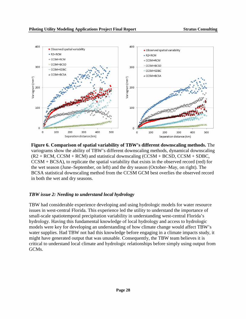
Piloting Utility Modeling Applications Project Final Report Stratus Consulting
Figure 6. Comparison of spatial variability of TBW’s different downscaling methods. The variograms show the ability of TBW’s different downscaling methods, dynamical downscaling (R2 + RCM, CCSM + RCM) and statistical downscaling (CCSM + BCSD, CCSM + SDBC, CCSM + BCSA), to replicate the spatial variability that exists in the observed record (red) for the wet season (June–September, on left) and the dry season (October–May, on right). The BCSA statistical downscaling method from the CCSM GCM best overlies the observed record in both the wet and dry seasons.
TBW issue 2: Needing to understand local hydrology
TBW had considerable experience developing and using hydrologic models for water resource issues in west-central Florida. This experience led the utility to understand the importance of small-scale spatiotemporal precipitation variability in understanding west-central Florida’s hydrology. Having this fundamental knowledge of local hydrology and access to hydrologic models were key for developing an understanding of how climate change would affect TBW’s water supplies. Had TBW not had this knowledge before engaging in a climate impacts study, it might have generated output that was unusable. Consequently, the TBW team believes it is critical to understand local climate and hydrologic relationships before simply using output from GCMs.
Page 28
Piloting Utility Modeling Applications Project Final Report Stratus Consulting
TBW issue 3: Developing a strong scientist/utility relationship
Utility and scientific personnel involved in the TBW project have cultivated a strong collaborative working relationship through the PUMA project, with both sides eager to discover what the science reveals. They have also engaged other scientific partners as needed for the research, such as the climate science team at the FSU COAPS for their downscaling work. Much of their progress in the project was because of the attitude the primary researchers have taken toward setting goals and evaluating results. Above all, they have taken an incremental approach, going where the research takes them rather than strictly adhering to a prescribed statement of work.
The TBW team identified how the partnership works to create a successful co-production dynamic: regular contact and organized interaction. In addition to the PUMA project, the utility and science leads for this PUMA project have also been working together on other projects, such as projects through the Florida Water and Climate Alliance and the SECC, a group that meets quarterly. Between these various projects, the two researchers have been in touch at least every two months. They have also planned agendas in advance of their meetings, even if just a telephone call, to maximize the value of each meeting and to stay on track.
3.4.3 How the PUMA project will affect utility decisions
TBW does not have an immediate need for the information provided through the PUMA project in decision-making. This means the PUMA team members have had the luxury of investing the time for this research. They have been able to explore all options and decide on the best methodology, instead of being pressured by a hard deadline. They have explored the best route for mainstreaming climate data into their decision-making, so when a major decision that needs to consider future projections arises, the team will have the modeling process ready. However, the TBW team’s work has generated growing interest both within and outside TBW. The PUMA team has had the opportunity to present its work to the senior leadership at TBW, and to other utilities and scientists in various regional forums. TBW has been able to have an effect on other water utilities in the region through the Florida Water and Climate Alliance.
Page 29

Piloting Utility Modeling Applications Project Final Report Stratus Consulting
4. Conclusions for an Applied Research Agenda for Climate Services
The formal goal of the PUMA project was “…to identify state-of-the-art modeling tools and techniques that can be used by water utilities to assess potential climate change impacts on their systems and watersheds.” The PUMA project was also motivated in part by the frustrations of decision-makers who were unable to penetrate the highly technical world of climate science. Other features of this environment that PUMA utilities had observed and sought to address included the paucity of scientists skilled and interested in translating complex science for a lay audience; a lack of research comparing and contrasting the various sources of climate projections and information; and relatively underdeveloped climate services, especially as compared to the burgeoning need at a local and regional level. In sum, the PUMA project was essentially an effort to learn by doing, to generate experience by creating collaboration between water managers and climate scientists, and to inform best co-production practice while generating an applied research agenda and set of outcomes specific to the needs of those utilities. The following are some conclusions based on the PUMA experience:
Assessment was local, and one size did not fit all. Assessment approaches can vary widely dependent on local needs. Although each PUMA project sought to illuminate a similar question – the impact of climate change on drinking water supplies – the four utilities pursued widely different approaches in service of that goal.
The scientist and utility-manager learning process was a two-way street. None of the PUMA utilities was a passive recipient of expert information from a climate modeler. All four utilities partnered with climate science experts to co-produce information that was useful to the specific water utility. In practice, the climate modelers themselves often had as much to learn about how water utilities model their systems as the water utility personnel had to learn about how climate modelers project future climate. For example, TBW developed a work plan for its PUMA project, but when those expectations turned out to be unrealistic, utility personnel worked with their climate modeler counterparts to redefine the investigation to produce useful information.
Water utilities sometimes needed to customize approaches to using climate model output. GCM output, downscaling techniques, and even baseline observational datasets used to validate climate projection tools frequently need to be customized for use in local assessments. Several utilities’ PUMA projects spent significant resources on comparing historical climate data for their specific systems/watersheds to ensure that future projections will be as accurate as possible (e.g., PWB, SPU, TBW).
Page 30
Piloting Utility Modeling Applications Project Final Report Stratus Consulting
Utilities required flexibility in exploring different methods to use climate model output. Each of the PUMA utilities followed a different path, using different data, models, and techniques to increase the resolution of GCM data. The point should not be to find the perfect method, but to get started and learn about climate change in general, and what your utility needs from climate models in particular. For example, NYCDEP did a tremendous amount of work using the CMIP3 models and a simple delta method for increasing the resolution of GCM data. In that process, the utility learned that it needed to know more about extreme events, and developed the SD-delta method to serve that need.
Utilities found that they needed to consider using a bottom-up as well as a top-down approach to climate modeling. A bottom-up approach begins by asking what is important in the context of a specific utility. A top-down approach begins by exploring what the science can tell us about how climate may change. The utilities profiled here used both approaches to find success in generating useful information. For example, TBW did not feel any immediate need to answer specific questions and was consequently more top-down and exploratory in its climate modeling work. SPU, on the other hand, took a bottom-up approach and drove its work based on pre-existing questions concerning likely impacts, including the onset of fall rains and atmospheric rivers. SPU also developed a suite of metric/thresholds with which to query the downscaled meteorological data in order to understand how conditions of interest may change in the future.
Information on changes in extreme event impacts was a major need for water utilities Although climate models do not easily capture extreme events, such events were the most sought-after projections for many of the utilities’ PUMA projects. For example, NYCDEP was most concerned about water-quality issues, including intense precipitation leading to turbidity events. SPU was concerned about intense precipitation leading to combined sewer overflow events or urban flooding, as well as extreme heat leading to catastrophic wildfires in its protected watershed. Because of this, several PUMA utilities developed their own approaches/methods to be able to more accurately model extreme events that matter to their systems (e.g., NYCDEP).
Understanding local hydrology was critical. Climate information, in the form of temperature, precipitation, solar radiation, winds, and other key variables, is only useful if a utility can translate that information into realistic water supply sources (e.g., stream flows, groundwater). This means that a good understanding of local hydro-meteorology is important to understand the impacts of climate change. TBW’s conclusion that the spatiotemporal variability in precipitation drove west-central Florida’s hydrology and PWB’s need to bias-correct historical climate datasets to match observed stream flow both indicated the critical nature of understanding local hydrology.
Page 31
Piloting Utility Modeling Applications Project Final Report Stratus Consulting
Utilities and scientists learned to adopt a “don’t hesitate to innovate” strategy. Some of the most successful aspects of the PUMA project occurred when water utilities and their scientific partners decided to create something new to meet their needs. Examples included the 25-bin approach that NYCDEP developed to capture a sense of extreme events using a delta method, and the BCSA downscaling technique that the TBW team developed to capture spatiotemporal variability in rainfall.
Page 32

Piloting Utility Modeling Applications Project Final Report Stratus Consulting
References ACCCNRS. 2014. Advisory Committee on Climate Change and Natural Resource Science. Available: https://nccwsc.usgs.gov/acccnrst
EO 13653. 2013. Executive Order 13653 of November 1, 2013. Preparing the United States for the Impacts of Climate Change. Available: http://www.whitehouse.gov/the-press-office/2013/11/01/executive-order-preparing-united-states-impacts-climate-change.
Executive Office of the President. 2013. The President’s Climate Action Plan. June. Available: http://www.whitehouse.gov/sites/default/files/image/president27sclimateactionplan.pdf.
IPCC. 1996. Climate Change 1995: The Science of Climate Change: Contribution of Working Group I to the Second Assessment Report of the Intergovernmental Panel on Climate Change. Cambridge University Press, Cambridge, UK and New York.
IPCC. 2013. Climate Change 2013: The Physical Science Basis, T.F. Stocker, D. Qin, G-K Plattner, M.M.B. Tignor, S.K. Allen, J. Boschung, A. Nauels, Y. Xia, V. Bex, and P.M. Midgley (eds.).Working Group I Contribution to the Fifth Assessment Report of the Intergovernmental Panel on Climate Change. Chapter 11 report graphics. Cambridge University Press, Cambridge, UK and New York.
Kanamitsu, M., K. Yoshimura, Y. Yhang, and S. Hong. 2010. Errors of interannual variability and multi-decadal trend in dynamical regional climate downscaling and its corrections. J Geophys Res 115:D17115.
Livneh, B., E.A. Rosenberg, C. Lin, B. Nijssen, V. Mishra, K.M. Andreadis, E.P. Maurer, and D.P. Lettenmaier. 2013. A long-term hydrologically based dataset of land surface fluxes and states for the conterminous United States: Update and extensions. J Climate 26:9384–9392. Available: http://dx.doi.org/10.1175/JCLI-D-12-00508.1.
Maurer, E.P., L. Brekke, T. Pruitt, and P.B. Duffy. 2007. Fine-resolution climate projections enhance regional climate change impact studies. Eos, Transactions American Geophysical Union 88(47):504.
Mearns, L.O., S.C. Pryor, and V. Magaña. 2014. Downscaling of climate information. In Climate Change in North America, Regional Climate Studies, G. Ohring (ed.). Springer International Publishing, Switzerland.
Raff, D., L. Brekke, K. Werner, A. Wood, and K. White. 2013. Short-term Water Management Decisions: User Needs for Improved Climate, Weather, and Hydrologic Information. Prepared
Page 33
Piloting Utility Modeling Applications Project Final Report Stratus Consulting
by and for the U.S. Army Corps of Engineers, the Bureau of Reclamation, and the National Oceanic and Atmospheric Administration. January. Available: http://www.ccawwg.us/docs/Short-Term_Water_Management_Decisions_Final_3_Jan_2013.pdf.
USACE. 2012. USACE 2012 Climate Change Adaptation Plan and Report. U.S. Army Corps of Engineers. June. Available: http://www.corpsclimate.us/docs/2012_USACE_Adaptation_Plan_and_Report_23_June_2012%20final.pdf.
USGCRP. 2012. The National Global Change Research Plan 2012–2021: A Strategic Plan for the U.S. Global Change Research Program. April. Available: http://downloads.globalchange.gov/strategic-plan/2012/usgcrp-strategic-plan-2012.pdf.
Wilby, R.L. and C.W. Dawson. 2012. The Statistical DownScaling Model: Insights from one decade of application. International Journal of Climatology 33(7):1707–1719.
WMO. 2011. Climate Knowledge for Action: The Global Framework for Climate Services – Empowering the Most Vulnerable. WMO-No. 1065. World Meteorological Organization, Switzerland. Available: ftp://ftp.wmo.int/Documents/SESSIONS/Cg-XVI/English/DOCs/d11-1%281%29_1065_HLT_report_en.pdf.
WUCA. 2009. Options for Improving Climate Modeling to Assist Water Utility Planning for Climate Change. Water Utility Climate Alliance. December. Available: http://www.wucaonline.org/assets/pdf/pubs_whitepaper_120909.pdf.
Page 34
Piloting Utility Modeling Applications Project Final Report Stratus Consulting
Suggested Resources Other WUCA reports
WUCA. 2009. Options for Improving Climate Modeling to Assist Water Utility Planning for Climate Change. Water Utility Climate Alliance. December. Available: http://www.wucaonline.org/assets/pdf/pubs_whitepaper_120909.pdf.
WUCA. 2010. Decision Support Planning Methods: Incorporating Climate Change Uncertainties Into Water Planning. January. Available: http://www.wucaonline.org/assets/pdf/pubs_whitepaper_012110.pdf.
WUCA. 2015. Embracing Uncertainty: A Case Study Examination of How Climate Change Is Shifting Water Utility Planning. Water Utility Climate Alliance. May. Available: http://www.wucaonline.org
NYCDEP PUMA technical papers
Anandhi, A., A. Frei, S.M. Pradhanang, M.S. Zion, D.C. Pierson, and E.M. Schneiderman. 2011. AR4 climate model performance in simulating snow water equivalent over Catskill Mountain watersheds, New York, USA. Hydrological Processes 25(21):3302–3311.
Anandhi, A., A. Frei, D.C. Pierson, E.M. Schneiderman, M.S. Zion, D. Lounsbury, and A.H. Matonse. 2011. Examination for change factor methodologies for climate change impact assessment. Water Resources Research 47(W03501). doi: 10.1029/2010WR009104.
PWB PUMA technical papers
Abatzoglou, J. and K. Hegewisch. 2013a. Climate Downscaling. University of Idaho. December 20.
Abatzoglou, J. and K. Hegewisch. 2013b. Climate Model Evaluation and Projections Synopsis. University of Idaho. December 20.
Chiao, T-H C., B. Nijssen, and D.P. Lettenmaier. 2013a. PUMA Project Phase I – Hydrologic Model for the Bull Run Watershed for Climate Change Analysis (Final Report). University of Washington, Department of Civil and Environmental Engineering. December 21.
Chiao, T-H C., B. Nijssen, and D.P. Lettenmaier. 2013b. Technical Memorandum #1 for the Portland Water Bureau PUMA Project Phase 1 – Hydrologic Model for the Bull Run Watershed
Page 35
Piloting Utility Modeling Applications Project Final Report Stratus Consulting
for Climate Change Analysis. University of Washington, Department of Civil and Environmental Engineering. April 29.
Livneh, B., E.A. Rosenberg, C. Lin, B. Nijssen, V. Mishra, K.M. Andreadis, E.P. Maurer, and D.P. Lettenmaier. 2013. A long-term hydrologically based dataset of land surface fluxes and states for the conterminous United States: Update and extensions. J. Climate 26:9384–9392. Available: http://dx.doi.org/10.1175/JCLI-D-12-00508.1.
SPU PUMA technical papers
Dalton, M.M. 2014. Technical Memorandum #4 for Seattle Public Utilities PUMA Project: “Return of Fall Rains Analysis.” Climate Impacts Research Consortium. August 22.
Dalton, M.M. and K. Hegewisch. 2014. Technical Memorandum #3 for Seattle Public Utilities PUMA Project: “Evaluation of Historic MACA-Downscaled Station Data.” Climate Impacts Research Consortium. June 2.
Hegewisch, K. and J. Abatzoglou. 2013. Technical Memorandum #2 for Seattle Public Utilities PUMA Project: “Climate Downscaling.” Climate Impacts Research Consortium.
Rupp, D.E., J.T. Abatzoglou, K.C. Hegewisch, and P.W. Mote. 2013. Evaluation of CMIP5 20th century climate simulations for the Pacific Northwest USA. J. Geophys. Res. Atmos. 118. doi: 10.1002/jgrd.50843.
TBW PUMA technical papers
Hwang, S. and W. Graham 2013a. Tampa Bay Water Climate Variability and Projections on Regional Water Supplies Project: Technical Report. September.
Hwang, S. and W.D. Graham. 2013b. Development and comparative evaluation of a stochastic analog method to downscale daily GCM precipitation. Hydrol Earth Syst Sci Discuss 10:2141–2181. doi: 10.5194/hessd-10-2141-2013.
Hwang, S., W. Graham, A. Adams, and J. Guerink. 2013c. Assessment of the utility of dynamically-downscaled regional reanalysis data to predict streamflow in west central Florida using an integrated hydrologic model. Regional Environmental Change. doi: 10.1007/s10113-013-0406-x.
Hwang, S., W. Graham, J.L. Hernández, C. Martinez, J.W. Jones, and A. Adams. 2011. Quantitative spatiotemporal evaluation of dynamically downscaled MM5 precipitation predictions over the Tampa Bay Region, Florida. J. Hydrometeor 12:1447–1464.
Page 36
Piloting Utility Modeling Applications Project Final Report Stratus Consulting
A. Applying Climate Model Outputs 101 for Water Utilities
In this section, we provide a general overview of general circulation models (GCMs), which are also called global climate models. We also discuss how a utility or their climate science partners might integrate GCMs into water utility models12 to support utility decision-making. This section discusses GCMs; emissions scenarios; GCM selection; increasing the resolution of GCM data, often known as downscaling; time steps; time periods; and integration of GCM outputs into utility models. We developed this appendix for decision-makers who are not familiar with GCMs or how their outputs might be used in utility models.
A.1 GCMs In general, GCMs simulate the world’s climate. They are often used to project what the Earth’s climate will be like in the future under assumptions about future emissions of greenhouse gases (GHGs). The outputs of these models have been used to inform long-term planning and investment decisions by water and other natural resource managers.
GCMs divide the world into a grid, with each grid box having the same degrees of latitude and longitude. All GCMs do not have uniformly sized grid boxes; they vary in size from approximately 60 miles to more than 200 miles (roughly 1 to 3°). Because of the large size of these grid boxes, small-scale climate features, such as mountain ranges, lakes, and irregular coastlines, which are often locally important, are not represented by GCMs. To begin to focus the global outputs on a particular region, researchers will isolate the grid box (or a set of contiguous grid boxes) of interest for each GCM and capture the model results for that grid box. This process allows the outputs from a global model to focus on a regional area of interest.
In this appendix, we discuss two generations of GCMs assembled as part of the Coupled Model Intercomparison Project (CMIP): the Phase 3 (CMIP3) models and the Phase 5 (CMIP5) models.13 The CMIP3 model runs were completed in the early 2000s for the IPCC Third Assessment Report (TAR) and Fourth Assessment Report (AR4). CMIP5 model runs were completed in the late 2000s and early 2010s for the IPCC Fifth Assessment Report (AR5). When the PUMA project began, the most widely used set of GCMs was from the CMIP3 generation;
12. For a more in-depth discussion of the science of climate modeling, see Options for Improving Climate Modeling to Assist Water Utility Planning for Climate Change (WUCA, 2009).
13. Phase 4 (CMIP4) was skipped in order to align CMIP numbering with the IPCC Assessment Reports (ARs).
Page A-1
Piloting Utility Modeling Applications Project Final Report Stratus Consulting
however, over the course of the project, the CMIP5 models were released. Some of the PUMA utilities stayed with CMIP3 for their analysis, while others used CMIP5.
A.2 Emissions Scenarios A key component of the climate modeling process is the selection of emissions scenario(s). Emissions scenarios are plausible narratives of future global social and economic development with associated GHG concentration levels and radiative forcings.14 They imply various future levels of GHG emissions, taking into consideration different development futures that factor in social changes such as economic conditions and population growth. Higher emissions scenarios will accelerate climate changes. Lower emissions scenarios, some of which assume reductions in future GHG emissions, would result in less severe climate changes.
In its last two assessments, the IPCC produced two types or “families” of emissions scenarios: the Special Report on Emissions Scenarios (SRES) and Representative Concentration Pathways (RCPs). The SRES scenarios were developed in 2000 and used for the TAR and AR4. They start with explicit assumptions about population and development and use these assumptions to define the emissions scenario trajectories. The RCP scenarios were developed in response to a request in 2007 to update, streamline, and modify the SRES scenarios, and were used in projections provided in the AR5 published in 2013. In contrast to SRES, RCPs assume specific changes in radiative forcing (i.e., roughly how much additional energy is trapped in the atmosphere by GHGs). Socioeconomic scenarios that present pathways on how these levels of radiative forcing can be reached are being developed.
A.3 GCM Selection Researchers will sometimes select a subset of the GCMs that best simulate observed climate for a specific area. They compare models’ re-creation of historical climate with the observational record. This is a way to eliminate models that perform relatively poorly in simulating current climate. However, there is no guarantee that models that best simulate current and past climate are the most reliable models for simulating future changes in climate. Nonetheless, the ability of models to simulate current and past climate patterns (e.g., which regions get more precipitation, season cycles of climate) is a widely used measure of a model’s relative skill.
14. Radiative forcing is defined by the IPCC as, “the perturbation to the energy balance of the Earth-atmosphere system (in watts per square meter) following, for example, a change in the concentration of carbon dioxide or a change in the output of the Sun; the climate system responds to the radiative forcing so as to re-establish the energy balance. A positive radiative forcing tends to warm the surface and a negative radiative forcing tends to cool the surface” (IPCC, 1996, p. 49).
Page A-2
Piloting Utility Modeling Applications Project Final Report Stratus Consulting
Uncertainties in Climate Modeling
Some major uncertainties concerning future climate change include (IPCC, 2013):
1. Future emissions of GHGs and other emissions, such as aerosols that affect climate. 2. The amount the Earth’s climate will warm in response to rising GHGs and other emissions, referred to
as “climate sensitivity” and typically expressed as the increase in average global temperature associated with a doubling of atmospheric carbon dioxide levels.
3. The patterns of change in regional climate as distinguished from global or continental change. This includes which regions will warm more than others, as well as which regions will get wetter or drier.
4. Natural climate variability. Variability ranges from short-term changes in climate (e.g., an increase or decrease in number of days with precipitation, change in precipitation intensity, change in heat waves) to seasonal variability (e.g., if winters get wetter and summers driers) to inter-annual variability (e.g., changes in the El Niño Southern Oscillation) to changes in drivers of decadal variability such as the Pacific Decadal Oscillation. Distinguishing between natural variability and climate change driven by increased GHG concentrations is challenging, especially in the near term, which is defined as several decades into the future.
Good practice captures a reasonably wide range of model projections of change in key variables, such as temperature and precipitation, to reflect uncertainty across model projections; this requires the use of many models. Furthermore, when presenting modeling results, a discussion of these uncertainties should always be included.
When researchers select a subset of GCMs and identify appropriate emissions scenarios (see discussion below), they can then obtain the simulations of current and future climates from the GCMs. They can download this information from various websites that publish GCM results (or use tools that provide GCM data). They can then isolate the grid box or grid boxes for their region to obtain projected changes to variables such as temperature, precipitation, and solar radiation.
The PUMA teams identified a subset of the GCMs to use in their analyses. Teams generally selected a set of models based on how well they simulate observed climate. However, the output from some climate models is not easy to obtain or the time scale of the output (e.g., daily or hourly versus monthly) is not at the scale needed for local analysis. This also drives the decision on which models to use. Since not all model outputs are available from one single location and not all variables are available at the same scale, this affects the decision on how many models are used in the local evaluation. For instance, PWB selected 20 CMIP5 models because these models have all the available variables needed for MACA downscaling. The teams sometimes further refined that selection to identify a number of models that encompass a range of outcomes (e.g., a range of temperature and precipitation projections). They also sometimes further reduced the number of models used to those that provide output that can be directly used in their operations and management models, such as temperature and precipitation projections at geographic and time scales consistent with their operations and management models.
Page A-3
Piloting Utility Modeling Applications Project Final Report Stratus Consulting
A range of models are generally used because no single model can represent a wide range of potential changes in future climate. Typically, utilities will try to capture a wide range of model projections, particularly on changes in precipitation. Change in this variable is very important for water utilities and the climate models tend to project a wide array of changes in precipitation. This often includes some models projecting increases while others project decreases.
It is important to avoid selecting a range of outputs that is too narrow (e.g., selecting only models that project reduced precipitation in a region when some models project increased precipitation). Thus, often a combination of models is selected (e.g., relatively “wet” and relatively “dry” models that encompass a substantial range of projections of changes in precipitation).
Often a middle outcome, such as a model with results in the middle of the range or reflecting an average of models, is also presented to not only include models that are toward the ends of the distribution range. Another option is to use average projections from a number of GCMs. It has been shown that when model simulations of current climate are averaged, the average is generally closer to observations than individual model simulations of current climate. But the average of models can smooth out spatial or temporal variability and change in extreme climate. It is generally considered more prudent to rely on a range of model output, particularly with changes in precipitation, rather than just the average of the model output. An alternative to using an average of the model output is to select a climate model whose projection of climate change is approximately in the middle of the range of all the models.
Many of the PUMA utilities decided to use a full complement of GCMs so that the full range of climate model output could be analyzed. But this increase in the number of GCMs and the number of model runs per GCM increased significantly from CMIP3 to CMIP5 and running all models may run into resource limitations at a utility.
A.4 Increasing the Resolution of GCM Data (Downscaling) GCM outputs alone often do not capture the level of spatial detail desired by water utilities and other decision-makers. The large size of the grid boxes does not account for topographic and other key differences within a grid box that may be critical (e.g., to accurately simulate precipitation in a particular watershed). The term “downscaling” generally has been used to refer to techniques to translate relatively coarse GCM outputs into more spatially disaggregated outputs that much better reflect the variance of climate conditions within a grid box.
To alleviate this problem, further refinement of GCM output is done to present regionally varied climate, which much more closely corresponds to actual climate conditions. The simplest approach, called the “delta method” or “delta-change technique” involves adjusting or combining the GCM estimated climate with observations to create a more spatially and temporally plausible dataset for a climate-altered future. The delta method adds (typically for
Page A-4
Piloting Utility Modeling Applications Project Final Report Stratus Consulting
temperature) or multiplies (typically for precipitation) the estimated change in a variable in a grid box to all observations within the grid box. In this approach, the change is assumed to be uniform across a grid box,15 but the estimated projections of temperature and precipitation will vary reflecting spatial differences in observations (e.g., higher altitudes will still be cooler than lower altitudes). Although it is not formally downscaling, this method provides a relatively simple approach to disaggregation of coarse GCM output.
A second and likely most commonly used approach is a family of statistical downscaling methods for bias correction and data disaggregation. Bias correction adjusts the GCM’s estimates of current climate to align with observed climate. The bias correction is applied across a distribution of observations (i.e., from high to low temperature and precipitation). Spatial disaggregation techniques are then used to develop higher spatial resolution observational datasets (e.g., Mauer et al., 2007) applies BCSD at 1/8th degree, or about 12 km)16 and in turn higher resolution climate change projections. Some PUMA partners that used these methods include TBW with the BCSA method (a customized technique) and PWB and SPU with the MACA method.17 It is important to note that these methods do not estimate how GCM projections of change at a coarse scale may vary within a grid box based on physical conditions such as local topography. This is because the adjustment to GCM output to have it better align with observations is also applied to model projections of future climate using those same observations.
The last two approaches discussed in this section attempt to simulate how change in climate may vary at much higher resolution than the GCMs simulate. Statistical Downscaling Models (SDSMs)18 statistically relate larger-scale meteorological conditions to local-level conditions. Typically, site-specific variables such as temperature or precipitation from individual weather stations are statistically correlated with larger-scale climate variables such as pressure patterns.19 This correlation is then combined with a GCM’s simulation of change in the larger-scale variable to estimate potential future site-specific temperature and precipitation. Wilby and Dawson (2012) SDSM is an example of this technique, which was not employed by any of the PUMA teams.
15. In some cases, GCM projections can be interpolated across grid boxes to smooth out changes and avoid sudden changes at the boundaries of grid boxes. In other cases, such as used by NYCDEP, the GCM changes can be divided into bins.
16. See http://gdo-dcp.ucllnl.org/downscaled_cmip_projections/dcpInterface.html for more information on the BCSD technique.
17. See http://maca.northwestknowledge.net for more information on the MACA technique.
18. Note that BCSD techniques are also widely referred to as statistical downscaling. This section is not discussing those methods, but so-called “statistical downscaling models.”
19. For example, site-specific temperature or precipitation may be correlated with a 500-mb geopotential height (Mearns et al., 2014).
Page A-5
Piloting Utility Modeling Applications Project Final Report Stratus Consulting
An important limitation of both statistical downscaling methods and statistical downscaling models is that they assume the statistical relationships that exist today will remain the same under climate change. This assumption, known as “stationarity” (e.g., that past recorded climate behavior will remain the same in the future), is likely incorrect, though in what way and to what degree is not yet known.
Dynamical downscaling uses RCMs that are similar to GCMs but only simulate a section of the Earth (e.g., North America), and do so at a much higher resolution than GCMs (e.g., 50 km and less rather than approximately 200 km). By doing so, RCMs attempt to capture important features such as mountains, coastlines, and large water bodies that influence regional climate conditions. Unlike statistical techniques, RCMs can account for physically based changes in climate. RCMs are “nested” within GCMs (i.e., a high-resolution RCM is run with conditions at the boundary of the model taken from a GCM). Examples of RCMs used by the PUMA utilities include the Weather Research and Forecasting (WRF)20 model used by NYCDEP, a mesoscale model known as MM521 used by NYCDEP and TBW, and TBWs use of output from FSU COAPS Regional Spectral Model (adapted from Kanamitsu et al., 2010). Even though they are run at a higher resolution than GCMs, at their current level of development in the United States, RCM output has generally been at lower resolution than most users’ desire and may not entirely resolve local-scale atmospheric processes. They are also significantly resource intensive, which limits the ability of water utilities to use them (they are frequently developed and run by large-scale research institutions).
It is important to note that while all of these techniques provide much greater spatial detail than what can be obtained from a GCM, it is not the case that any technique to increase GCM data resolution will correct errors from GCMs or reduce the range of projections from multiple GCMs. In fact, scientists often warn that each and every step in the assessment process, including downscaling of GCM projections, may introduce additional uncertainties to the process.
A.5 Time Steps One factor the PUMA teams considered in selecting their GCMs was the temporal resolution of the outputs. Some model outputs are saved as a single value per day, while other outputs are saved with finer temporal refinement, such as at a three hourly scale. In the climate modeling field, these timescales are often referred to as “time steps.” The available output time steps were
20. WRF is a collaboration among the National Center for Atmospheric Research (NCAR), NOAA, the Air Force Weather Agency, the Naval Research Laboratory, the University of Oklahoma, and the Federal Aviation Administration.
21. MM5 is the fifth-generation Pennsylvania State University and NCAR Mesoscale Model.
Page A-6
Piloting Utility Modeling Applications Project Final Report Stratus Consulting
a critical decision factor for the water utilities because their utility models (e.g., hydrologic models, operations or management models, flooding models) are designed to receive inputs at specific time steps. Note that average monthly change in climate is a common time step for climate model output. This can be satisfactory for estimating change in water supply through operations models in many cases.22 Flooding, on the other hand, tends to be very sensitive to smaller time steps such as daily or sub-daily (e.g., hourly) precipitation amounts. For modeling combined sewer overflow events, time steps as short as five minutes were reported as being used by PUMA utilities in their own modeling. In the end, it was most common for PUMA utilities to select GCM data at a daily time step and then disaggregate that data into subdaily time steps when necessary.
A.6 Time Periods Utilities and climate modelers must consider another temporal dimension in the climate modeling process. GCM projections are typically calculated by averaging 20–30 future yearly projections to a single simulated year. If only one, or even several, projected years are used, that year or years could be a simulated bad drought year or a particularly wet period, and represent climate variability more than climate change.23 Thirty years of observed weather is typically used to define a climate (e.g., the period 1981–2010 is used to define average climate) and a 30-year (or even a 20-year) period of simulated future climate can be used to define a climate in the future. So GCM yearly projections might be considered in a near-term grouping (i.e., 2035 being the average of 2020–2050), mid-term (i.e., 2065 being the average of 2050–2080), and long-term (i.e., 2085 being the average of 2070–2100).
An additional decision is on how far into the future climate change is simulated. This is also important because the magnitude of climate change is greater further into the future, but also more uncertain. Impacts many years from now may not be as relevant to a water utility. Each team needs to make the decision about what time periods it will examine depending on what the utility’s needs or interests are. For example, if a utility is making a long-term investment in a large piece of infrastructure, it might consider long-term projections (e.g., out to 100 years from the present). A simple rule-of-thumb is that projected changes within three decades of current climate (e.g., projecting from 2015 out to 2045) will likely be dominated by natural variability.
22. This is the case when a water system uses reservoirs, which can attenuate the daily variability of stream flow. But for many utilities who rely on run-of-river flows, monthly averaged climate output is not sufficient to analyze impacts to water supply.
23. On the other hand, when people select a GCM based on long-term averages, they lose the details of month-to-month or year-to-year variability. This means that certain interesting aspects of future GCM projections could be lost through averaging.
Page A-7
Piloting Utility Modeling Applications Project Final Report Stratus Consulting
The signal from climate change typically takes several decades to clearly emerge from the “noise” of natural variability.
A.7 Climate Models into Utility Models The GCMs provide climate model projections for specific variables such as temperature or precipitation which can then be used in utility models to examine how changes in climate might propagate through water systems and affect utilities’ abilities to meet demands. This type of exercise is often referred to as a “chain-of-models” because it involves inputting data from one model into another model.
The concept of chain-of-models refers to the sequence of models that must be used to apply climate information in a water utility context. For example, the outputs from a GCM can be used as inputs into a hydrology model, and that hydrology model translates the GCM output into streamflow or groundwater recharge to be used as inputs into a system management or operations model. The outputs of those utility models can then help define the impacts of climate change on water supply, water quality, and other parameters commonly modeled by water utilities. In this way GCM data can help to identify potential impacts on water system performance.
Page A-8
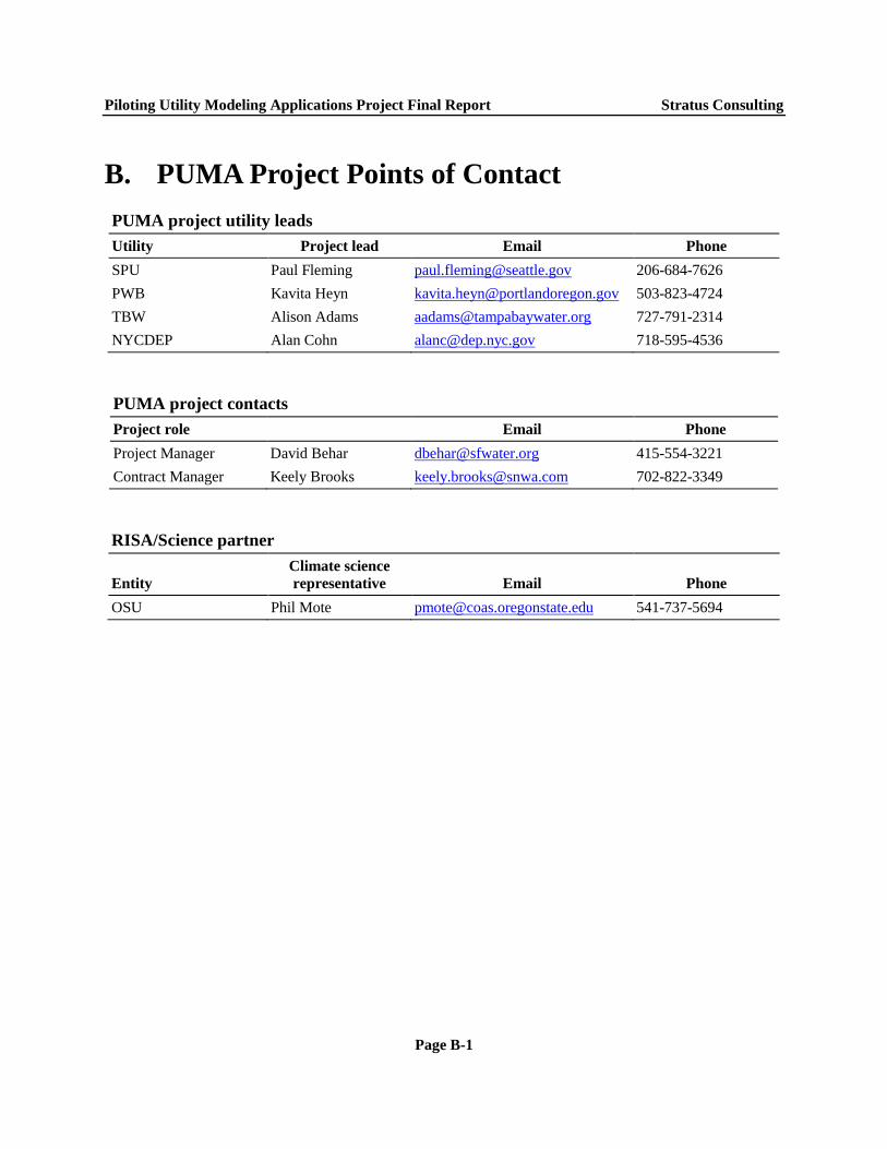
Piloting Utility Modeling Applications Project Final Report Stratus Consulting
B. PUMA Project Points of Contact PUMA project utility leads Utility Project lead Email Phone SPU Paul Fleming [email protected] 206-684-7626 PWB Kavita Heyn [email protected] 503-823-4724 TBW Alison Adams [email protected] 727-791-2314 NYCDEP Alan Cohn [email protected] 718-595-4536
PUMA project contacts Project role Email Phone Project Manager David Behar [email protected] 415-554-3221 Contract Manager Keely Brooks [email protected] 702-822-3349
RISA/Science partner
Entity Climate science representative Email Phone
OSU Phil Mote [email protected] 541-737-5694
Page B-1