Embed Size (px)
DESCRIPTION
Â
Citation preview
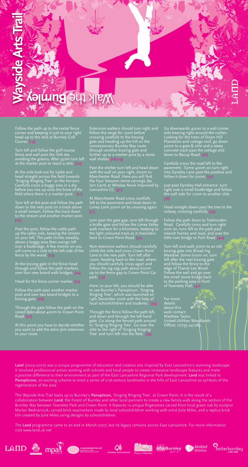
Land (2003-2007) was a unique programme of education and creative arts inspired by East Lancashire’s stunning landscape. It involved professional artists working with schools and local people to create innovative landscape features and make a positive difference to their environment as part of the East Lancashire Regional Park development. Land was linked to Panopticons, an exciting scheme to erect a series of 21st-century landmarks in the hills of East Lancashire as symbols of the regeneration of the area.
The Wayside Arts Trail leads up to Burnley’s Panopticon, ‘Singing Ringing Tree’, at Crown Point. It is the result of a collaboration between Land, the Forest of Burnley and other local partners to create a new family walk along the section of the Burnley Way between Towneley Park and Crown Point. It features 12 unique fingerposts carved from local green oak by sculptor Martyn Bednarczuk, carved brick waymarkers made by local schoolchildren working with artist Julie Miles, and a replica brick kiln created by Julie Miles using designs by schoolchildren.
The Land programme came to an end in March 2007, but its legacy remains across East Lancashire. For more information visit www.land.uk.net
Follow the path up to the metal fence corner and keeping it just to your right head up to the stile at Burnley Golf Course. [19]
Turn left and follow the golf course fence and wall past the 16th.tee, avoiding the greens. After 350m turn left at the marker post to reach a stile. [20]
At the stile look out for cattle and head straight across the field towards ‘Singing Ringing Tree’ on the horizon. Carefully cross a boggy area in a dip before you rise up onto the brow of the field where there is a marker post. [21]
Turn left at the post and follow the path down to the next post on a track above a small stream. Follow the track down to the stream and another marker post. [22]
Past the post, follow the cattle path up the valley side, keeping the stream on your left. The path climbs steadily, above a boggy area then swings left over a footbridge. A few metres on you will come to a stile to the left side of the fence by the wood. [23]
At the kissing gate in the fence head through and follow the path markers over four new board walk bridges. [24]
Head for the fence corner marker. [25]
Follow the path past another marker post and over two board bridges to a kissing gate. [26]
Through the gate follow the path on the raised dyke about 400m to Crown Point Road. [27]
At this point you have to decide whether you want to add the extra 5km extension to your route.
Extension walkers should turn right and follow the verge for 150m before crossing carefully to the kissing gate and heading up the hill on the concessionary Burnley Way route through another kissing gate and further up to a marker post by a stone wall shelter. [28/29]
Past the shelter turn left and head down with the wall on your right, 600m to Manchester Road. Here you will find the Four Seasons stone carvings (by Iain Cant) at Wholaw Nook improved by Lancashire CC. [30]
At Manchester Road cross carefully left to the pavement and head down to Limey Lane 300m on by crossing again. [31]
50m past the gate gap, turn left through a bridle gate and follow the Limey Valley walk markers for a kilometre, keeping to the light coloured track as it meanders back to Crown Point Road. [32]
Non extension walkers should carefully climb the stile and cross Crown Point Lane to the new path. Turn left after 150m, heading back to the road, where you should carefully cross again and follow the zig-zag path about 600m up to the fence gap to Crown Point Car park. [33]
Here, to your left, you should be able to see Burnley’s Panopticon, ‘Singing Ringing Tree’, which was launched on 14th December 2006 with the help of local schoolchildren and students. [34]
Through the fence follow the path left, and down and through the left hand gate. Go along the fenced path around to ‘Singing Ringing Tree’. Go over the stile to the right of ‘Singing Ringing Tree’ and turn left into the field. [35]
Go downwards 400m to a wall corner stile bearing right around the rushes. Looking for the trees of Dixon Hill Plantation and cottage roof, go down 300m to a gate & stile and a steep concrete track past the cottage and down to Bacup Road. [36]
Carefully cross the road left to the pavement. Some 400m on turn right into Dyneley Lane past the postbox and follow it down for 500m. [37]
Just past Dyneley Hall entrance turn right over a small footbridge and follow the wall side for 100m to another stile. [38]
Head straight down past the tree to the railway, crossing carefully. [39]
Follow the path down to Todmorden Road. Carefully cross and turn right. 20m on, turn left to the path past newish homes and road, and over the little river bridge to Park Road. [40]
Turn left and walk 300m to an old kissing gate into Broad Ing Meadow. Some 600m on, turn left after the next kissing gate and follow the fence to the edge of Thanet Lee Wood. Follow the wall and go over the small stone bridge back to the parking area in front of Towneley Hall. [41]
For more details about this walk contact: Matthew Taylor, United Utilities Woodlands Officer, 07795 241083
Way
side
Arts
Tra
il
Walk the Burnley
the trail
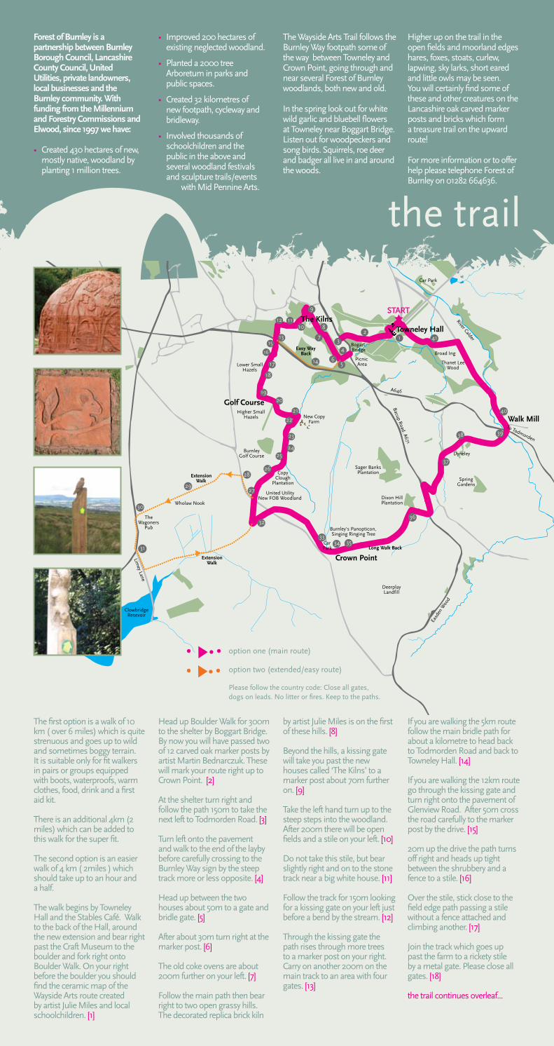
Forest of Burnley is a partnership between Burnley Borough Council, Lancashire County Council, United Utilities, private landowners, local businesses and the Burnley community. With funding from the Millennium and Forestry Commissions and Elwood, since 1997 we have:
• Created 430 hectares of new, mostly native, woodland by planting 1 million trees.
• Improved 200 hectares of existing neglected woodland.
• Planted a 2000 tree Arboretum in parks and public spaces.
• Created 32 kilometres of new footpath, cycleway and bridleway.
• Involved thousands of schoolchildren and the public in the above and several woodland festivals and sculpture trails/events with Mid Pennine Arts.
The Wayside Arts Trail follows the Burnley Way footpath some of the way between Towneley and Crown Point, going through and near several Forest of Burnley woodlands, both new and old.
In the spring look out for white wild garlic and bluebell flowers at Towneley near Boggart Bridge. Listen out for woodpeckers and song birds. Squirrels, roe deer and badger all live in and around the woods.
Higher up on the trail in the open fields and moorland edges hares, foxes, stoats, curlew, lapwing, sky larks, short eared and little owls may be seen. You will certainly find some of these and other creatures on the Lancashire oak carved marker posts and bricks which form a treasure trail on the upward route!
For more information or to offer help please telephone Forest of Burnley on 01282 664636.
The first option is a walk of 10 km ( over 6 miles) which is quite strenuous and goes up to wild and sometimes boggy terrain. It is suitable only for fit walkers in pairs or groups equipped with boots, waterproofs, warm clothes, food, drink and a first aid kit.
There is an additional 4km (2 miles) which can be added to this walk for the super fit.
The second option is an easier walk of 4 km ( 2miles ) which should take up to an hour and a half.
The walk begins by Towneley Hall and the Stables Café. Walk to the back of the Hall, around the new extension and bear right past the Craft Museum to the boulder and fork right onto Boulder Walk. On your right before the boulder you should find the ceramic map of the Wayside Arts route created by artist Julie Miles and local schoolchildren. [1]
Head up Boulder Walk for 300m to the shelter by Boggart Bridge. By now you will have passed two of 12 carved oak marker posts by artist Martin Bednarczuk. These will mark your route right up to Crown Point. [2]
At the shelter turn right and follow the path 150m to take the next left to Todmorden Road. [3]
Turn left onto the pavement and walk to the end of the layby before carefully crossing to the Burnley Way sign by the steep track more or less opposite. [4]
Head up between the two houses about 50m to a gate and bridle gate. [5]
After about 30m turn right at the marker post. [6]
The old coke ovens are about 200m further on your left. [7]
Follow the main path then bear right to two open grassy hills. The decorated replica brick kiln
by artist Julie Miles is on the first of these hills. [8]
Beyond the hills, a kissing gate will take you past the new houses called ‘The Kilns’ to a marker post about 70m further on. [9]
Take the left hand turn up to the steep steps into the woodland. After 200m there will be open fields and a stile on your left. [10]
Do not take this stile, but bear slightly right and on to the stone track near a big white house. [11]
Follow the track for 150m looking for a kissing gate on your left just before a bend by the stream. [12]
Through the kissing gate the path rises through more trees to a marker post on your right. Carry on another 200m on the main track to an area with four gates. [13]
If you are walking the 5km route follow the main bridle path for about a kilometre to head back to Todmorden Road and back to Towneley Hall. [14]
If you are walking the 12km route go through the kissing gate and turn right onto the pavement of Glenview Road. After 50m cross the road carefully to the marker post by the drive. [15]
20m up the drive the path turns off right and heads up tight between the shrubbery and a fence to a stile. [16]
Over the stile, stick close to the field edge path passing a stile without a fence attached and climbing another. [17]
Join the track which goes up past the farm to a rickety stile by a metal gate. Please close all gates. [18]
the trail continues overleaf...
option one (main route)
option two (extended/easy route)
Please follow the country code: Close all gates, dogs on leads. No litter or fires. Keep to the paths.


![Postpr int - diva-portal.org1082837/FULLTEXT01.pdf · Rajput MS, Burman M, ... [MPa] Comp. modulus [MPa] Tensile modulus [MPa] Shear modulus [MPa] ArmaFORM AC115 AC115 115 1.8 120/80*](https://img.pdfslide.us/doc/110x75/5e780f3f9174782dd22241ae/postpr-int-diva-1082837fulltext01pdf-rajput-ms-burman-m-mpa-comp.jpg)


![Valve terminal MPA-S - Festo USA · Pneumatic components description Valveterminalwith MPA-Spneumatics Type: MPA-FB MPA-CPI MPA-MPM-…and MPA-ASI-… 534241 1309f [8028624] Valve](https://img.pdfslide.us/doc/110x75/5c5bd85409d3f236368c6efe/valve-terminal-mpa-s-festo-usa-pneumatic-components-description-valveterminalwith.jpg)