Embed Size (px)
Citation preview

p a
r k n
o t
e Mount Samaria State ParkVisitor Guide
Set in tall, shady eucalypt forest, Mount Samaria State Park offers a cool,
quiet retreat for walking, camping and picnicking. Experience a variety of
breathtaking views over the Victorian Alps, granite outcrops, and historic
remains.
How to get there
Superb Lyrebird
Natural featuresGeological history dates to 500 million years ago with the depositing of marine sands and silt. More recent activity (50 million years ago) caused the uplifts that form the ridges of the Park.
The variation in soils, fire history and altitude has created a wide range of habitats. Beneath the majestic Blue Gums and Mountain Grey Gum, the moist environment supports a dense understorey of wattles, dogwood and bracken. The drier forests of stringybarks, boxes and peppermints expose an open understorey of hardy shrubs and tussock grasses. An array of wildflowers include peas, trigger plants, everlasting daisies, milkmaids and orchids.
Mount Samaria hosts a variety of Australian wildlife including kangaroos, wallabies, wombats, echidnas, possums and gliders, and the granite rocks provide warm homes for a variety of lizards and snakes. The park is also a haven for many
Mount Samaria State Park is 130 km north-east of Melbourne, 28 km south of Benalla on the Samaria Road via Swanpool, and 14km north of Mansfield via the Whitfield Road. A gravel road traverses the range from north to south and, although steep and rocky in places, is open all year to most vehicles.
Things to see and doCamping and picnicking: Spring Creek Sawmill and Samaria Well offer camping and picnicking facilities. Walk-in campsites are at Wild Dog Falls Creek and Camphora and all sites have toilets and fireplaces. Creek water is available at most sites, but supply may be limited during drier periods. Supply your own drinking water.
Advance booking and payment for camping required year round.
No fees apply to these campsites.Walking: The park features a range of walking tracks to experience the semi-remote nature of the park. See map for further details.
Lookouts: Experience spectacular views from Mt Samaria Summit, Rocky Point Lookout and Wild Dog Creek Falls.
Wildflowers: During spring and early summer the forest is alive with brilliant displays of wildflowers.
birds including lyrebirds, rosellas and the Wedge-tailed Eagle.
HeritageThe Samaria ranges were a source of food for the local Aboriginal community. During the European squatting era in the 1840s, much of the area was heavily grazed.
Blessed with magnificent stands of mature trees, the Samaria range came under the scrutiny of timber cutters, and in the 1920s saw a large scale timber industry in operation. By 1928, failing yields led to the closure of the mills and logging became intermittent until an area of about 7000 hectares was declared as State Park in 1979.
Spring Creek Sawmill ruins, including kilns and mounds of sawdust, can still be found.
July 2015
For more information call the Parks Victoria Information Centreon 13 1963 or visit our website at www.parkweb.vic.gov.au

D MANS
AO'HALLORAN AD
RO RD RO RD
YROAD
AD O R
CK
TRA
E GG IN
D NRII
07
A
T
HT
RRSO RN1
NEO RP
RKOADHA C
BARJARG
TRACK
N
RAR
MWA
IAT IS
DL
EAAN
LAD
EL
MRO
H MOUNTJOLI A
CY ROADD
TDINISTULLEY ROAD MI
LANE
GANDINIS LANE GAGANDNDLAIINNNEII
Samaria SAWYEREVRADNS
SAMARIA ROAD C
SHOOLHO
ROA
SAW US RO
ER D YER
O TA
T
D OAR
IE LM
TO NGO
TAT
CK TR
A
S NE
JOK C ASSTRTREE NNJOJO
DD AARORO
E COOTI
NILLAH TR
ACK
08
M IDL
AN
KHEWSON
D
C
HARPERS
AD
HARPERS
RORO AD
EEK RC JOHNSTONSBarjarg
GLEN
A300
SP
RIN
GN
Mount Samaria State Park Recreational Facilities0 500 1000 1500
Highway
Sealed road
Unsealed road
Vehicle track
State Park
Other public land
Reference area
Water body
Boat ramp
Camping
Campsite - Walk in
Carpark
Lookout
Park information
Picnic table
Toilets
M E T R E S Cartography by Spatial Vision 2002 M/5155
Walking track
Gate
Fireplace MELBOURNE*•
To Benalla
•Wangaratta
•Benalla •
Myrtleford
•Whitfield
MOUNT SAMARIA STATE PARK
• Mansfield
Lima South
Samaria Well
B300To
Wrightley
For further informationMansfield
Visitor Information Centre (Railway
Station) Mansfield, Vic 3722
Tel: 5775 7000
Benalla Visitor Information
Centre 14 Mair Street
Benalla, Vic 3672Tel: 5762 1749
Lake Nillahcootie Day Visitor Area
LAKE
NILLAHCOOTIE
Mount Samaria Summit
953m
•
Wild Dog Creek Falls
Spring Creek
Sawmill
Kiln Ruin
ThompsonThompson''ss Mill
Caring for the environment
Help us look after your parks by
remembering these guidelines:
Please take rubbish
Mount Samaria Walks(Distances are one way)Wild Dog Falls & Lookout - 1.5kmFrom Mt. Samaria Road the track leads to the top of the waterfalls where you can enjoy views
FallsCamphora Campsite
BLUE RANGE REFERENCE AREA
(No Access)
home with you forrecycling or disposal
All plants, animals, archaeological
sites and geographic features are
protected by law
Dogs and other pets are not permitted
Firearms are prohibited
Light fires only in fireplaces provided
No fires, including barbecues, may be lit
on a day ofTotal Fire Ban.
Mount Samaria is in theNorth
East Total Fire Ban District
over Lake Nillahcootie and the Strathbogie Ranges.Back Creek Falls - 1.5kmA gently cascading waterfall, accessible from the start of the Wileman Track off Mt Samaria Road.Mt. Samaria SummitAt a height of 953m, the summit offers 360 degree views across the Alps and lowlands.- 4.8km (from Sawmill site) (Moderate to Steep)To Mansfield- 2.5km circuit (from Mt. Samaria Rd)(Steep)Tramway Walk - 3.8kmBegin near the Spring Creek Sawmill site and follow the old timber tramway down to the remains of the Braking
Back Creek Falls
Rocky Point
Lookout
•
Blue Range Creek Picnic & Camping Area
Vehicles, including
Station.
•The Bald Hills •
motor bikes, may only be used on formed open
roads. Drivers must be licensed and vehicles registered and roadworthy
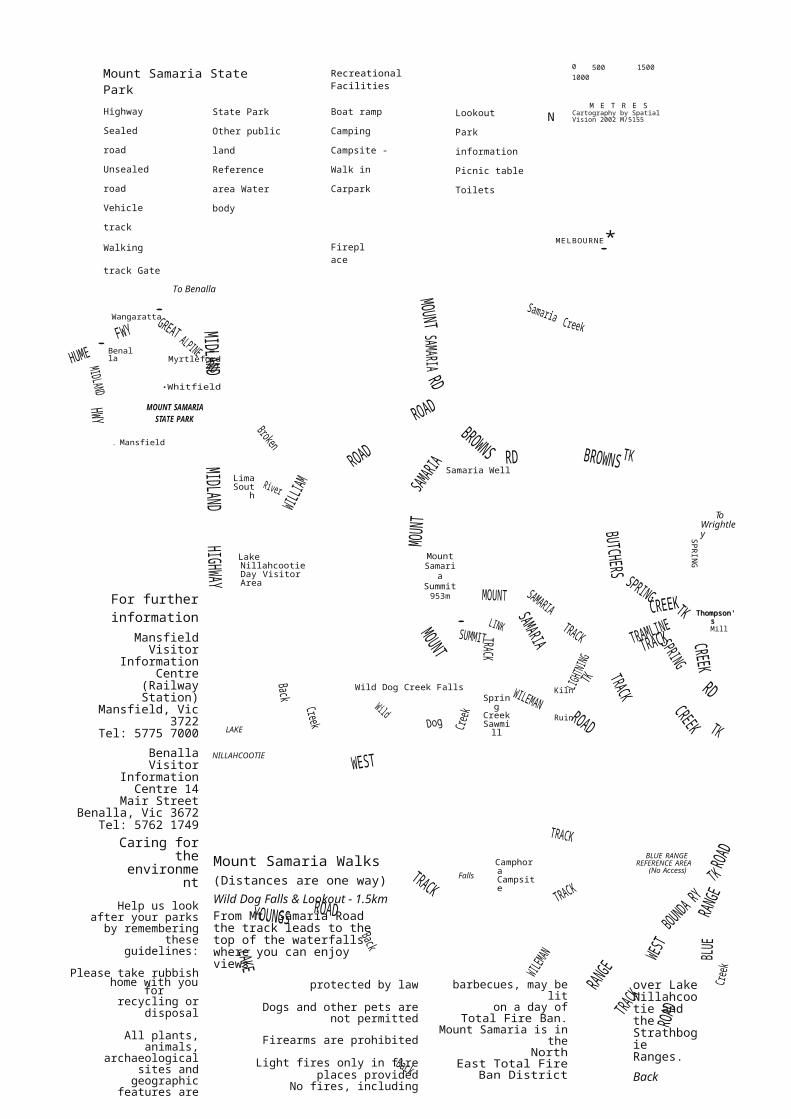
Wileman Track - 7kmLinks Back Creek and Wild Dog Creek Falls. Leave vehicle at the
gates at each end or return along the main road.