Embed Size (px)
Citation preview
Rezoning
Application
AVIEMORE
ESTATE
VPM PLANNING
Aviemore Rezoning Motivation Report June 2013
TABLE OF CONTENTS
1. INTRODUCTION ...................................................................................................................... 1 2. BACKGROUND ........................................................................................................................ 1 3. PROPERTY DESCRIPTION .................................................................................................... 2
3.1 LOCALITY .................................................................................................................................................... 2 3.2 SIZE AND OWNERSHIP ............................................................................................................................. 2 3.3 TITLE DEED ................................................................................................................................................ 4
4. BIO –PHYSICAL SITE ANALYSIS .......................................................................................... 4
4.1 TOPOGRAPHY ............................................................................................................................................ 4 4.2 ENVIRONMENTAL CONSIDERATIONS ................................................................................................... 5 4.3 IMPROOFMENTS........................................................................................................................................ 5
5. PROPOSAL .............................................................................................................................. 5
5.1 THE DEVELOPMENT CONCEPT .............................................................................................................. 5 5.2 LAYOUT ....................................................................................................................................................... 6
5.2.1 Access & Circulation .................................................................................................................................. ... 6 5.2.2 Parking ...................................................................................................................................................... ... 7 5.2.3 Building Placement .................................................................................................................................... ... 8 5.2.4 Units size and numbers .............................................................................................................................. ... 8 5.2.5 Aesthetics .................................................................................................................................................. ... 8 5.2.6 Safety ........................................................................................................................................................ ... 8
5.3 ZONING PARAMETERS .......................................................................................................................... .. 9 5.4 PHASING AND SUBDIVISION ................................................................................................................... 9 5.5 ENGINEERING SERVICES ...................................................................................................................... 10
5.5.1 Water Supply ............................................................................................................................................... 10 5.5.2 Sewer Disposal ............................................................................................................................................ 11 5.5.3 Storm Water Management ........................................................................................................................... 11 5.5.4 Electricity ..................................................................................................................................................... 12 5.5.5 Solid Waste ................................................................................................................................................. 13
5.6 LEGAL REQUIREMENTS ...................................................................................................................................... 13 5.6.1 Land Use Planning Ordinance (Ordinance 15 of 1985): ................................................................................ 13 5.6.2 National Environmental Management Act (Act 107 of 1998): ......................................................................... 13 5.6.3 The South African National Roads Agency Limited and National Roads Act, 1998 (Act No.7 of 1998) : ........ 14 5.6.4 National Heritage Recourse Ac 1999 ............................................................................................................ 14
6. MOTIVATION.......................................................................................................................... 14 6.1 NEED .......................................................................................................................................................................... 14
6.1.1 Need for affordable Housing ......................................................................................................................... 14 6.1.2 Socio –Economic Need of the Sedgefield Community ................................................................................... 16 6.1.3 The need for higher density ......................................................................................................................... 16
6.2 DESIRIBILITY......................................................................................................................................................... 17 6.2.1 Locality ........................................................................................................................................................ 17 6.2.2 Bio-Physical site Characteristic ..................................................................................................................... 18
6.3 URBAN CONTEXT .................................................................................................................................................. 18 6.3.1 Strategic View of the Area ................................................................................................................................ 18 6.3.2 Impact on the larger Sedgefield area ............................................................................................................ 21 6.3.3 Impact on the Aviemore Estate ..................................................................................................................... 23
7. CONCLUSION ........................................................................................................................ 24
LIST OF PLANS Diagram 1: Locality Plan Diagram 2: Aerial Photo Diagram 3: Contour Plan & Slope Analysis Diagram 4: Critical Biodiversity Area Map Diagram 5: Land Use Plan Diagram 6: Zoning Map Diagram 7: Site Development Plan Diagram 8: Phased Subdivision Plan
LIST OF ANNEXURE: Annexure A: Power of Attorney and Company Resolutions Annexure B: Copy of the Title Deeds and Deed searches Annexure C: General Plans Surveyor General Diagrams Annexure D: Architectural Proposals Annexure E: Previous Approvals and Agreements Annexure F: Civil Engineering Reports Annexure G: Electrical Engineering Report Annexure H: Letter from Aviemore HOA
1
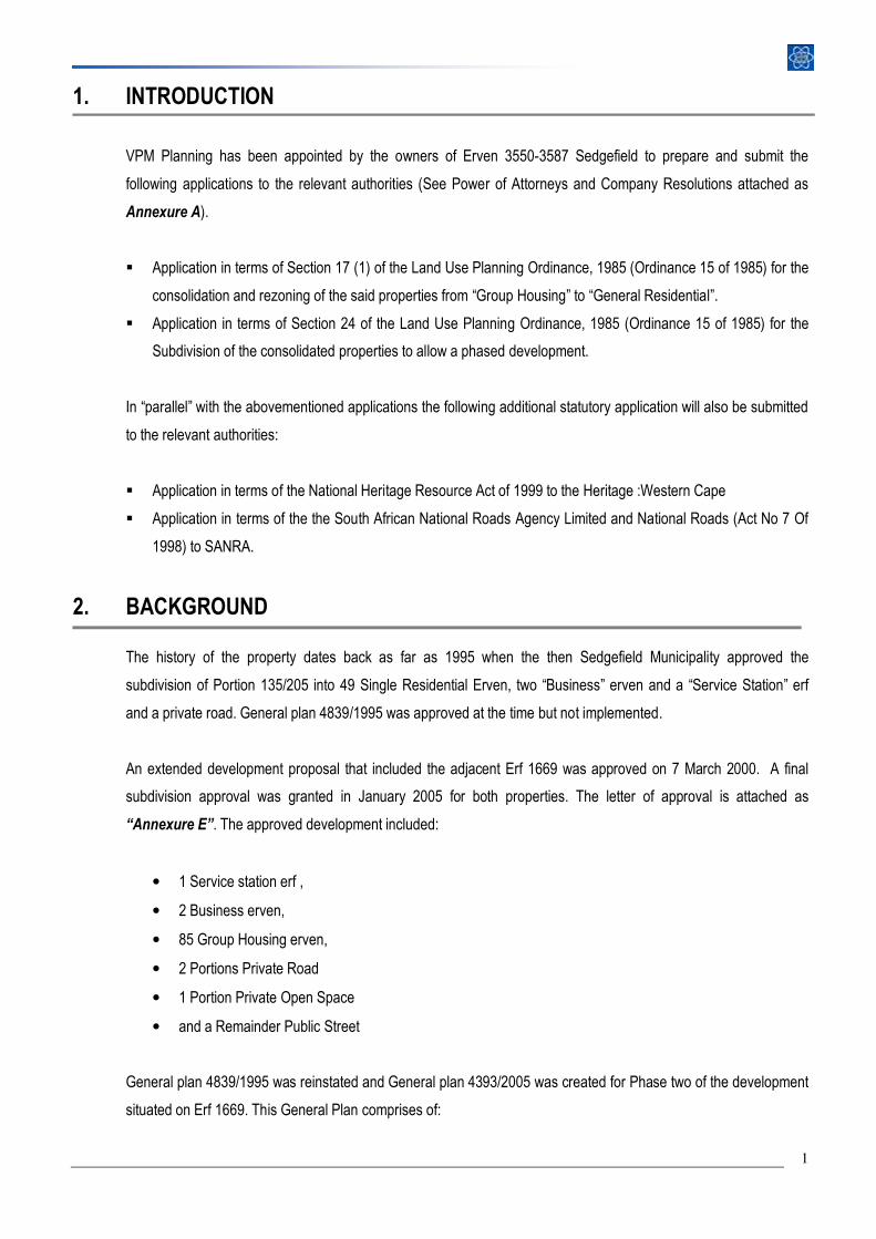
1. INTRODUCTION
VPM Planning has been appointed by the owners of Erven 3550-3587 Sedgefield to prepare and submit the
following applications to the relevant authorities (See Power of Attorneys and Company Resolutions attached as
Annexure A).
� Application in terms of Section 17 (1) of the Land Use Planning Ordinance, 1985 (Ordinance 15 of 1985) for the
consolidation and rezoning of the said properties from “Group Housing” to “General Residential”.
� Application in terms of Section 24 of the Land Use Planning Ordinance, 1985 (Ordinance 15 of 1985) for the
Subdivision of the consolidated properties to allow a phased development.
In “parallel” with the abovementioned applications the following additional statutory application will also be submitted
to the relevant authorities:
� Application in terms of the National Heritage Resource Act of 1999 to the Heritage :Western Cape
� Application in terms of the the South African National Roads Agency Limited and National Roads (Act No 7 Of
1998) to SANRA.
2. BACKGROUND
The history of the property dates back as far as 1995 when the then Sedgefield Municipality approved the
subdivision of Portion 135/205 into 49 Single Residential Erven, two “Business” erven and a “Service Station” erf
and a private road. General plan 4839/1995 was approved at the time but not implemented.
An extended development proposal that included the adjacent Erf 1669 was approved on 7 March 2000. A final
subdivision approval was granted in January 2005 for both properties. The letter of approval is attached as
“Annexure E”. The approved development included:
• 1 Service station erf ,
• 2 Business erven,
• 85 Group Housing erven,
• 2 Portions Private Road
• 1 Portion Private Open Space
• and a Remainder Public Street
General plan 4839/1995 was reinstated and General plan 4393/2005 was created for Phase two of the development
situated on Erf 1669. This General Plan comprises of:
2
• 37 Residential Stands
• 1 Private Open Space and
• 1 Private Road Erf
The focus of this study is the area covered by General plan 4393/2005 attached as Annexure C. The first phase of
the development has been implemented and several properties have been sold and some houses have been
constructed. The second phase of the development has been implemented in terms of service provision. Ten
properties have been sold and one house has been constructed.
3. PROPERTY DESCRIPTION
3.1 LOCALITY
Aviemore Estate is situated to
the north east of the Sedgefield
urban area. The development is
directly north of the N2 and
south of the railway line as
indicated on the attached
Locality Plan (Diagram 1). The
development gain access via
Egret Street. The study area
comprises the second phase of
the Aviemore development
which is situated on the eastern
section of the development.
Figure 1: Aviemore from the N2
3.2 SIZE AND OWNERSHIP
All the properties that are indicated on General Plan 4393/2005 except for Erf 3549, which is the only one that has
been developed, will be consolidated to form a new development properly. Nine of the stands have been sold to 6
individual owners. These owners have agreed to become part of the new development and the have all signed
Power of attorneys to this effect. The original developer (Avieprop Developments Pty Ltd) of the estate still owns the
remaining 27 residential stands, as well as the private road and private open space erven. Should the Rezoning
application be successful, a new development company will be created and all the properties will be transferred to
this company to allow the consolidation thereof.
3
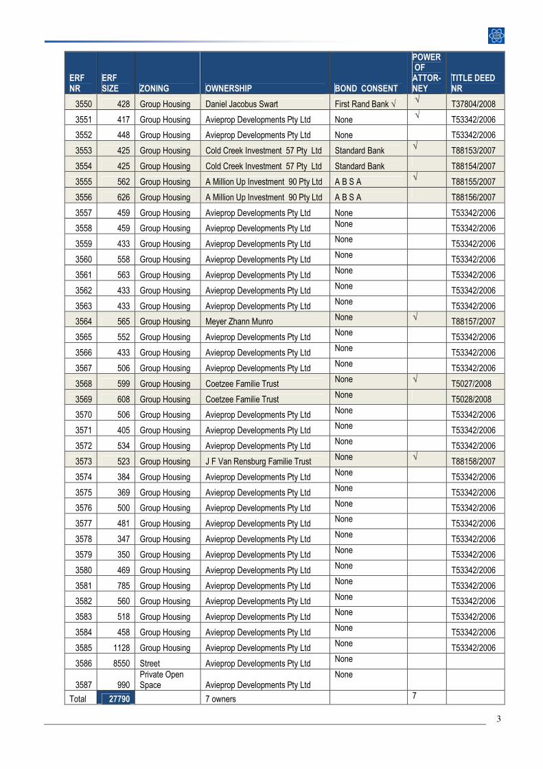
ERF NR
ERF SIZE ZONING OWNERSHIP BOND CONSENT
POWER OF ATTOR-NEY
TITLE DEED NR
3550 428 Group Housing Daniel Jacobus Swart First Rand Bank √ √ T37804/2008
3551 417 Group Housing Avieprop Developments Pty Ltd None √ T53342/2006
3552 448 Group Housing Avieprop Developments Pty Ltd None T53342/2006
3553 425 Group Housing Cold Creek Investment 57 Pty Ltd Standard Bank √ T88153/2007
3554 425 Group Housing Cold Creek Investment 57 Pty Ltd Standard Bank T88154/2007
3555 562 Group Housing A Million Up Investment 90 Pty Ltd A B S A √ T88155/2007
3556 626 Group Housing A Million Up Investment 90 Pty Ltd A B S A T88156/2007
3557 459 Group Housing Avieprop Developments Pty Ltd None T53342/2006
3558 459 Group Housing Avieprop Developments Pty Ltd None T53342/2006
3559 433 Group Housing Avieprop Developments Pty Ltd None T53342/2006
3560 558 Group Housing Avieprop Developments Pty Ltd None T53342/2006
3561 563 Group Housing Avieprop Developments Pty Ltd None T53342/2006
3562 433 Group Housing Avieprop Developments Pty Ltd None T53342/2006
3563 433 Group Housing Avieprop Developments Pty Ltd None T53342/2006
3564 565 Group Housing Meyer Zhann Munro None √ T88157/2007
3565 552 Group Housing Avieprop Developments Pty Ltd None T53342/2006
3566 433 Group Housing Avieprop Developments Pty Ltd None T53342/2006
3567 506 Group Housing Avieprop Developments Pty Ltd None T53342/2006
3568 599 Group Housing Coetzee Familie Trust None √ T5027/2008
3569 608 Group Housing Coetzee Familie Trust None T5028/2008
3570 506 Group Housing Avieprop Developments Pty Ltd None T53342/2006
3571 405 Group Housing Avieprop Developments Pty Ltd None T53342/2006
3572 534 Group Housing Avieprop Developments Pty Ltd None T53342/2006
3573 523 Group Housing J F Van Rensburg Familie Trust None √ T88158/2007
3574 384 Group Housing Avieprop Developments Pty Ltd None T53342/2006
3575 369 Group Housing Avieprop Developments Pty Ltd None T53342/2006
3576 500 Group Housing Avieprop Developments Pty Ltd None T53342/2006
3577 481 Group Housing Avieprop Developments Pty Ltd None T53342/2006
3578 347 Group Housing Avieprop Developments Pty Ltd None T53342/2006
3579 350 Group Housing Avieprop Developments Pty Ltd None T53342/2006
3580 469 Group Housing Avieprop Developments Pty Ltd None T53342/2006
3581 785 Group Housing Avieprop Developments Pty Ltd None T53342/2006
3582 560 Group Housing Avieprop Developments Pty Ltd None T53342/2006
3583 518 Group Housing Avieprop Developments Pty Ltd None T53342/2006
3584 458 Group Housing Avieprop Developments Pty Ltd None T53342/2006
3585 1128 Group Housing Avieprop Developments Pty Ltd None T53342/2006
3586 8550 Street Avieprop Developments Pty Ltd None
3587 990 Private Open Space Avieprop Developments Pty Ltd
None
Total 27790 7 owners 7
4
Table 1: Property description
3.3 TITLE DEED
The Title deeds of the individual properties has been attached as Annexure B. The Title Deeds do not contain any
conditions that will restrict the development of the property as envisaged.
Five of the properties are encumbered by bonds. The bondholders consent has been requested and will be
forwarded as soon as available.
4. BIO –PHYSICAL SITE ANALYSIS
4.1 TOPOGRAPHY
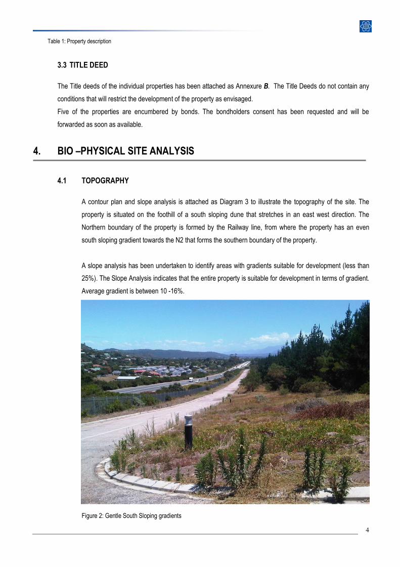
A contour plan and slope analysis is attached as Diagram 3 to illustrate the topography of the site. The
property is situated on the foothill of a south sloping dune that stretches in an east west direction. The
Northern boundary of the property is formed by the Railway line, from where the property has an even
south sloping gradient towards the N2 that forms the southern boundary of the property.
A slope analysis has been undertaken to identify areas with gradients suitable for development (less than
25%). The Slope Analysis indicates that the entire property is suitable for development in terms of gradient.
Average gradient is between 10 -16%.
Figure 2: Gentle South Sloping gradients
5
4.2 ENVIRONMENTAL CONSIDERATIONS
There are no sensitive environmental features on the site. The entire site is presently approved for a group
housing development. The property is not situated in Critical Biodiversity Areas, Ecological Support Areas,
or Protected Areas (See Diagram 4: Critical Biodiversity Areas)
4.3 IMPROVEMENTS
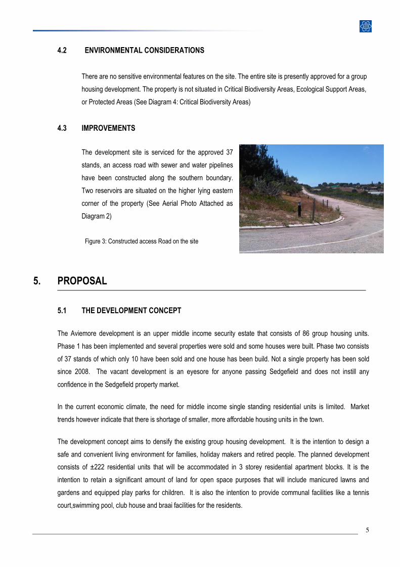
The development site is serviced for the approved 37
stands, an access road with sewer and water pipelines
have been constructed along the southern boundary.
Two reservoirs are situated on the higher lying eastern
corner of the property (See Aerial Photo Attached as
Diagram 2)
Figure 3: Constructed access Road on the site
5. PROPOSAL
5.1 THE DEVELOPMENT CONCEPT
The Aviemore development is an upper middle income security estate that consists of 86 group housing units.
Phase 1 has been implemented and several properties were sold and some houses were built. Phase two consists
of 37 stands of which only 10 have been sold and one house has been build. Not a single property has been sold
since 2008. The vacant development is an eyesore for anyone passing Sedgefield and does not instill any
confidence in the Sedgefield property market.
In the current economic climate, the need for middle income single standing residential units is limited. Market
trends however indicate that there is shortage of smaller, more affordable housing units in the town.
The development concept aims to densify the existing group housing development. It is the intention to design a
safe and convenient living environment for families, holiday makers and retired people. The planned development
consists of ±222 residential units that will be accommodated in 3 storey residential apartment blocks. It is the
intention to retain a significant amount of land for open space purposes that will include manicured lawns and
gardens and equipped play parks for children. It is also the intention to provide communal facilities like a tennis
court,swimming pool, club house and braai facilities for the residents.
6
Smaller, low maintenance units will accommodate a wide range of buyers from holiday makers who are looking for a
lock up and go holiday apartment to retired people looking for a low maintenance secure environment to live in, or
first time home owners that seeks an affordable investment.
5.2 LAYOUT
Quality architecture and functional and safe open spaces are the central ingredients of liveable communities. The
proposed layout provides for 15 three storey residential blocks containing approximately 222 units of various sizes.
The units will vary from 40 m² to 60m². The preliminary Site Development plan is attached as Diagram 7
5.2.1 Access & Circulation
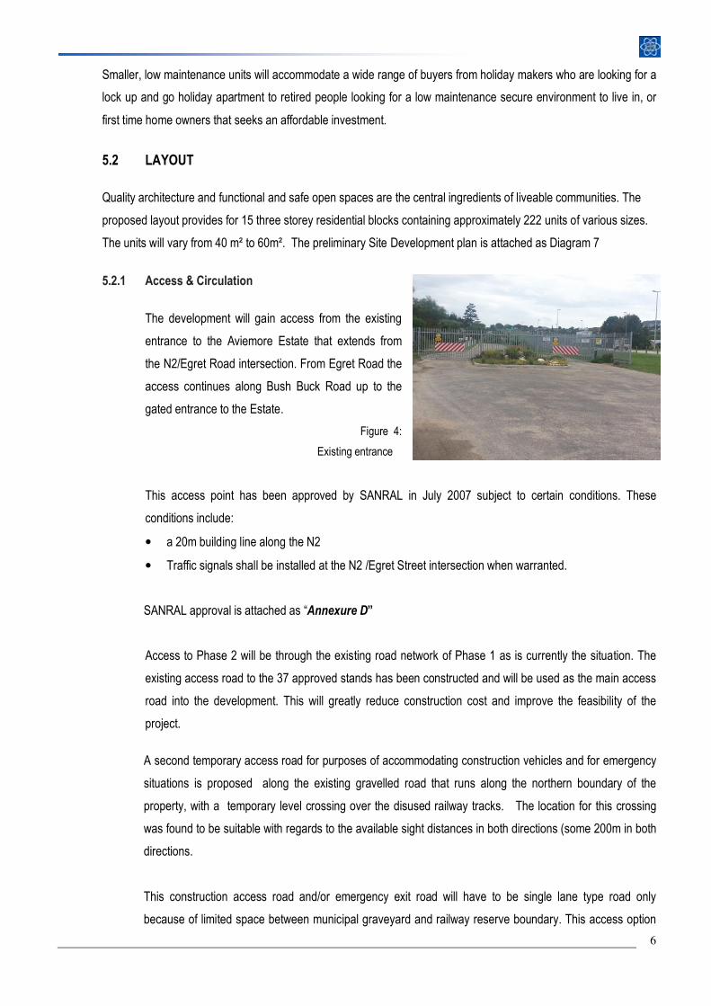
The development will gain access from the existing
entrance to the Aviemore Estate that extends from
the N2/Egret Road intersection. From Egret Road the
access continues along Bush Buck Road up to the
gated entrance to the Estate.
Figure 4:
Existing entrance
This access point has been approved by SANRAL in July 2007 subject to certain conditions. These
conditions include:
• a 20m building line along the N2
• Traffic signals shall be installed at the N2 /Egret Street intersection when warranted.
SANRAL approval is attached as “Annexure D”
Access to Phase 2 will be through the existing road network of Phase 1 as is currently the situation. The
existing access road to the 37 approved stands has been constructed and will be used as the main access
road into the development. This will greatly reduce construction cost and improve the feasibility of the
project.
A second temporary access road for purposes of accommodating construction vehicles and for emergency
situations is proposed along the existing gravelled road that runs along the northern boundary of the
property, with a temporary level crossing over the disused railway tracks. The location for this crossing
was found to be suitable with regards to the available sight distances in both directions (some 200m in both
directions.
This construction access road and/or emergency exit road will have to be single lane type road only
because of limited space between municipal graveyard and railway reserve boundary. This access option
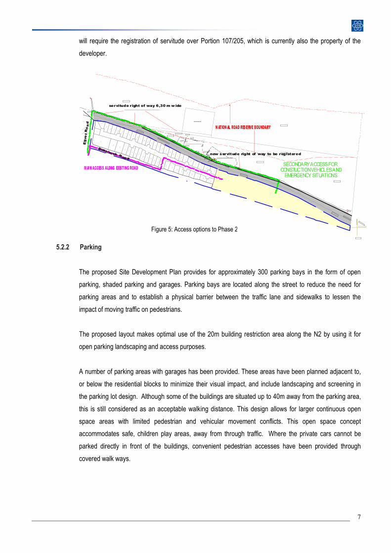
7
will require the registration of servitude over Portion 107/205, which is currently also the property of the
developer.
5.2.2 Parking
The proposed Site Development Plan provides for approximately 300 parking bays in the form of open
parking, shaded parking and garages. Parking bays are located along the street to reduce the need for
parking areas and to establish a physical barrier between the traffic lane and sidewalks to lessen the
impact of moving traffic on pedestrians.
The proposed layout makes optimal use of the 20m building restriction area along the N2 by using it for
open parking landscaping and access purposes.
A number of parking areas with garages has been provided. These areas have been planned adjacent to,
or below the residential blocks to minimize their visual impact, and include landscaping and screening in
the parking lot design. Although some of the buildings are situated up to 40m away from the parking area,
this is still considered as an acceptable walking distance. This design allows for larger continuous open
space areas with limited pedestrian and vehicular movement conflicts. This open space concept
accommodates safe, children play areas, away from through traffic. Where the private cars cannot be
parked directly in front of the buildings, convenient pedestrian accesses have been provided through
covered walk ways.
SECONDARY ACCESS FOR CONSTUCTION VEHICLES AND EMERGENCY SITUATIONS
new servitude right of way to be registered
Eg
ret
Ro
ad
M AIN ACCESS ALONG EXISTING ROAD
Bushbuck Road
servitude right of way 6,30 m w ide
N ATION AL ROAD RESERVE BOUNDARY
Figure 5: Access options to Phase 2
8
5.2.3 Building Placement
The proposed Site Plan shows 15 residential buildings that contains 12- 18 units each. The buildings
contain 3 storeys each. All the buildings are north facing. The buildings have been placed in clusters that
overlook a central park. All the units have balconies that overlook the park or the hills to the north
5.2.4 Units size and numbers
The intention is to include a diversity of unit sizes. The current site plans shows the maximum number
units that could be accommodated on the site. Most of the buildings blocks contain small bachelor flats or
one bedroom apartments that measures between 40m² and 60m². A maximum unit number of ±222 is
proposed. On a property of ±2.8ha, this number calculate to a maximum density of 80 units per ha.
Should the market dictate bigger apartments, the smaller units could be combined and redesigned as one
bigger unit. This will give the developer maximum flexibility to adapt to a changing property market.
5.2.5 Aesthetics
Appropriate architecture and landscaping will play a vital role in creating a high quality living environment.
The site will require some buffering, screening, and landscaping between the N2 and the development.
The Knysna Municipality however indicated (in their requirement for the existing development) that they are
not in support of a solid screening wall, because such wall will create a tunnel effect along the N2 which
could have a negative visual impact on the tourist and other road users entering or exiting the town.
The local authority recommended that a palisade fence be erected and that dense vegetation be planted
along the fence to act as screening.
5.2.6 Safety
Design for safety is also a significant issue. It aims to minimise the opportunity for crime and reduce the
fear of crime for people using private and public space. The layout is based on the following set of safety
principles:
• maximise visibility and surveillance of the public environment
• reduce the isolation of people, like dark narrow walkways and areas that make them vulnerable to
crime
• clearly define open space with active building fronts facing public space
• manage open space to ensure that it is attractive and well used
9
• appropriate lighting that will not impact on adjoining properties will enhance safety and visibility at
night.
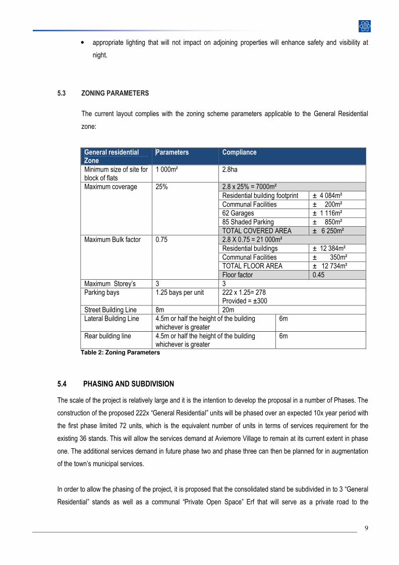
5.3 ZONING PARAMETERS
The current layout complies with the zoning scheme parameters applicable to the General Residential
zone:
General residential Zone
Parameters Compliance
Minimum size of site for block of flats
1 000m² 2.8ha
Maximum coverage 25% 2.8 x 25% = 7000m² Residential building footprint ± 4 084m² Communal Facilities ± 200m² 62 Garages ± 1 116m² 85 Shaded Parking ± 850m² TOTAL COVERED AREA ± 6 250m²
Maximum Bulk factor 0.75 2.8 X 0.75 = 21 000m² Residential buildings ± 12 384m² Communal Facilities ± 350m² TOTAL FLOOR AREA ± 12 734m² Floor factor 0.45
Maximum Storey’s 3 3 Parking bays 1.25 bays per unit 222 x 1.25= 278
Provided = ±300 Street Building Line 8m 20m Lateral Building Line 4.5m or half the height of the building
whichever is greater 6m
Rear building line 4.5m or half the height of the building whichever is greater
6m
Table 2: Zoning Parameters
5.4 PHASING AND SUBDIVISION
The scale of the project is relatively large and it is the intention to develop the proposal in a number of Phases. The
construction of the proposed 222x “General Residential” units will be phased over an expected 10x year period with
the first phase limited 72 units, which is the equivalent number of units in terms of services requirement for the
existing 36 stands. This will allow the services demand at Aviemore Village to remain at its current extent in phase
one. The additional services demand in future phase two and phase three can then be planned for in augmentation
of the town’s municipal services.
In order to allow the phasing of the project, it is proposed that the consolidated stand be subdivided in to 3 “General
Residential” stands as well as a communal “Private Open Space” Erf that will serve as a private road to the
10
individual erven. Subdivision Plan is attached Diagram 8. The individual units will be sold under a sectional title
scheme.
5.5 ENGINEERING SERVICES
Avieprop Developments Pty Ltd appointed NIEUWOUDT & KIE Engineers to prepare a Civil Services Report. The
Report is attached as Annexure F. The focus of the report is the engineering implications of replacing 36 residential
stands with 222 small residential units.
5.5.1 Water Supply
Only 14 stands in the western corner of the development that is currently supplied with municipal water, the
rest of the Aviemore Development that consist of 75 residential stands is supplied with water from two
existing registered on site boreholes.
The increase water demand for phase 2 due to the planned densification will amount to:
Present demand: 36 x group housing stands @ 1.20kℓ per day = 43.2kℓ per day
Future demand 222x general residential units @ 0,50kℓ per day = 111,00kℓ per day
ADDITIONAL DEMAND = 67,8kℓ per day
Phase 1 of the development will be limited to approximately 86 units which will calculate to an equivalent
demand for he approved 36 stands.
The existing municipal supply that has been implemented for part of Aviemore is functioning well and
extending this supply to the proposed “General Residential” area will involve merely the laying of new
pipeline of some 200m long. Council has confirmed that they are presently completing augmentation
measures from the Karatara River to their bulk water supply for Sedgefield and thus that water supply
capacity will be available for the planned densification of the development. This option, being the
conventional way of water supply to residential developments inside municipal area, is considered the
preferred water supply option for the additional water demand.
The existing groundwater source is proposed as an alternative supply option for the abovementioned
increased water demand for the rest of the planned development. The existing groundwater source has
been investigated and tested in 2005 by a specialist Geo-Hydrologist, Messrs’ GORRA Water from George,
with the conclusion after extensive borehole testing being that each of the existing boreholes can safely
deliver 2, 5 litre per second flow over a 17 hour daily period which exceed the total future water demand of
the existing and planned development. The quality of the ground water used since 2007 has been found to
11
be good and copy of records received from the HOA of the chemical testing thereof is attached to the
engineering report.
Rain water harvesting from roofs of new buildings will be implemented as per the requirements of Knysna
Municipality, which could effectively reduce the above water requirement.
The Engineering Report further confirms that adequate capacity is available in the existing reticulation
pipelines and the hydraulic pressure booster system and no upgrading thereof will be required. The
capacity of the existing reservoirs is however inadequate if the borehole option is to be implemented. The
borehole option will most probably require that the capacity of the existing reservoirs be increased or that
another reservoir be constructed on site. There is sufficient space available for a third reservoir adjacent to
the existing two reservoirs in the eastern most corner of the study area.
5.5.2 Sewer Disposal
Aviemore Village development is provided with municipal water bourn sewer disposal service to the
Sedgefield Sewer Treatment works via the existing sewer pump stations that are located in the Groenvallei
area of town on the opposite side of the “N2” National Road.
The Engineering Report confirms that measured daily sewage flow from this treatment work shows that
there is spare capacity available in the plant. The full chemical lab testing done monthly by specialist
chemical consultants for the municipality however show that measured organic loading or “COD” of the
sewage is very high, which limit the final effluent quality to comply with “General Standards” but not to the
required “Special Standards”. In order to improve the abovementioned high organic “COD” loading of the
incoming sewage at the plant, more inflow from water bourn sewage serving permanent type housing
rather holiday type housing is required. It is therefore safe to say that the proposed development may
improve the functioning of the plant.
The capacity of the existing sewer reticulation is reported to be adequate to deal with the increased sewer
flow. There will be some new sewer connections required to suit the layout of the general residential versus
single residential, but generally this is minor practical issue and the existing reticulation can remain in place
as is. This will ensure the financial viability of the project.
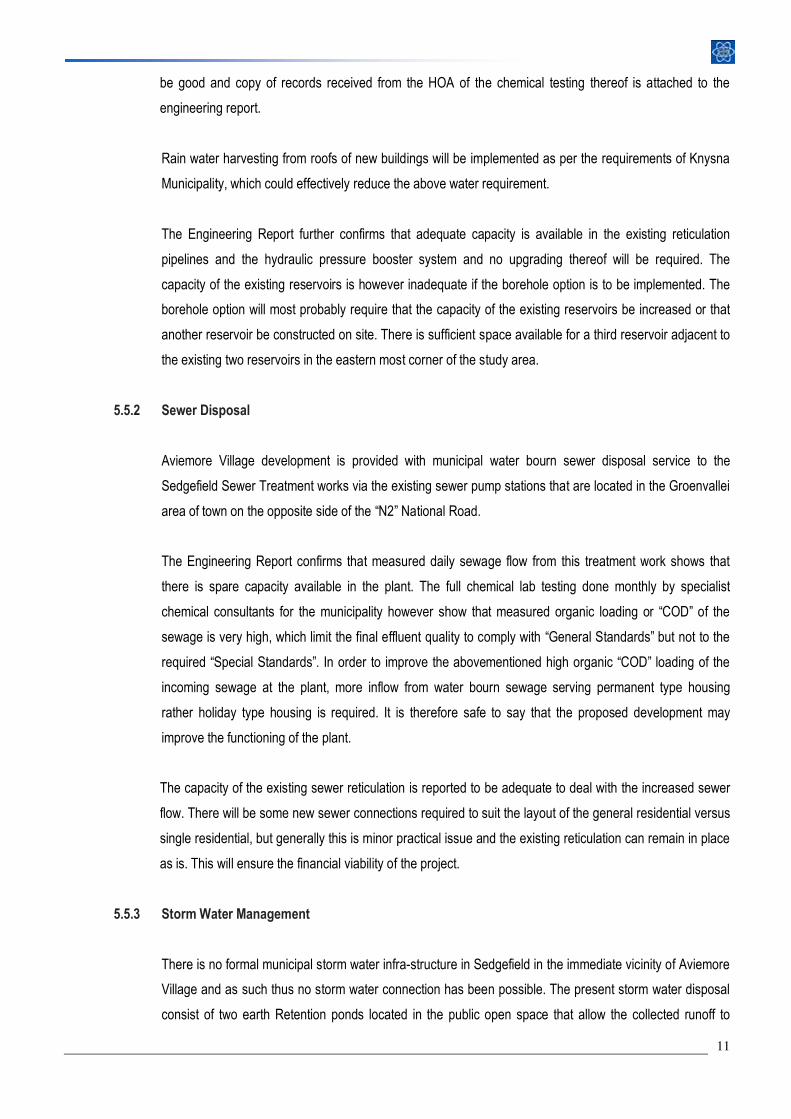
5.5.3 Storm Water Management
There is no formal municipal storm water infra-structure in Sedgefield in the immediate vicinity of Aviemore
Village and as such thus no storm water connection has been possible. The present storm water disposal
consist of two earth Retention ponds located in the public open space that allow the collected runoff to
12
percolate or soak-away into the natural ground. These retention ponds have functioned successfully during
all the flood conditions since 2007.
It is expected that the proposed general residential re-development with its higher density will result in a
higher runoff due to more of the affected hectare area being covered with hardened surfaces, i.e. more
paved parking and roadways. It is proposed to provide for a third retention pond in the open area in
between the existing ones. Another site measure that will be implemented across the large parking areas is
the use “permeable paving” that will allow natural surface drainage with some water penetration.
Figure 6 and 7: Two storm water catch pits on site
5.5.4 Electricity
An Electrical Services Report was prepared by Clinkscales Maughan-Brown Electrical Engineers have
been appointed as the Electrical Consultants for this project. The Report is attached as “Annexure G”.
The Town Electro-technical Engineer indicated that the development can be supplied from the existing
electricity network in the area, subject to the following bulk upgrading measures being undertaken as part
of the development:
(i) Supply, installation and commissioning of some 350 metres of 300mm² Aluminium 11kV
underground cables as an extension of an existing cable installed by the Municipality from their
Main Intake Substation up to some 350m from their 11kV Switching Station “SS-Sedgefield East”.
(ii) Supply and installation of a new 11kV circuit breaker panel inside “SS-Sedgefield East” and
connection of the cable in Item (i) above, as an extension of the existing 11kV switchgear panel.
(iii) Extension of the existing “SS-Sedgefield East” switching station building to accommodate the
additional switchgear required.
The availability of bulk electrical capacity is not considered to be a problem for this densification project.
Energy saving measures as mentioned hereunder will be investigated and implemented where
economically viable, in order to reduce the demand on the national grid:
• Natural ventilation to be taken into account in designs of buildings.
13
• The energy used to heat water to be reduced by reducing the amount of hot water used by fitting
low-flow shower heads and faucet aerators.
• Thermal insulation of geysers (geyser blankets) and hot water pipes.
• Geyser control relays to switch of geysers during peak periods.
• Energy efficient lighting design and making use of compact fluorescent lamps.
5.5.5 Solid Waste
Central collection point at the gate house will be provided.
5.6 LEGAL REQUIREMENTS
The following legal procedures will apply to this development.
5.6.1 Land Use Planning Ordinance (Ordinance 15 of 1985):
It is proposed that the 36 undeveloped properties be consolidated and rezoned from “Group Housing“ and
“Private Open Space” to “General Residential” in terms of the Land Use Planning Ordinance (Ordinance 15
of 1985).
5.6.2 National Environmental Management Act (Act 107 of 1998):
The application does not trigger any listed activities in terms of the National Environmental Management
Act (Act 107 of 1998). The 36 Group Housing stands are serviced and cannot be regarded as derelict land.
The site is further more situated in an urban area and not in a Critical Biodiversity area (See Diagram 4 :
Critical Biodiversity areas Map).
The two properties zoned as Private Open space are respectively used for road and reservoir purposes
and the functions of these areas will not be altered. These areas will therefore not be transformed.
Although the proposal will not trigger any listed activities, the principles of best environmental practice
contained in NEMA still apply and the developer need to take these into consideration during the planning
and construction of the development.
14
5.6.3 The South African National Roads Agency Limited and National Roads Act, 1998 (Act No.7
of 1998):
The site borders onto the N2 and subsequently the consent from The South African National Roads
Agency Limited and National Roads Act, 1998 (Act No.7 of 1998) will be required. The application has
been forwarded to this department for their further comment and approval.
5.6.4 National Heritage Resource Act 1999
Section 38 of The National Heritage Resource Act 1999 states that person who intend any development
that will change the character of the site exceeding 5000m² in extend or involve more than 3 erven, or the
rezoning of a site exceeding 10 000m², must notify the responsible Heritage Resource Agency of his/her
intend to develop. This development falls under this category and the applicant will forward the required
detail to the Heritage Western Cape.
6. MOTIVATION
In terms of the NEMA EIA principles, when considering an application the decision making authority must have regard to a
number of specific considerations including specifically having to consider “the need for and desirability of the activity”.
Need refers to time i.e. is this the right time for the envisaged development .The proposal will be motivated by confirming the
need for the planned residential land use. The application will further be motivated by investigating the desirability of the
property for the planned land use. Desirability refers to the place, i.e. is the land suitable for locating the type of land-
use/activity being proposed?
Lastly, the development will be evaluated against the expected impacts on the surrounding environment and adjacent
properties.
6.1 NEED
6.1.1 Need for affordable Housing
The first question that needs to be asked when any development is considered is whether there is a need
for the contemplated land use in the market place. This is normally a question that the potential investor
would answer before they embark on a long and expensive application process. Development, like any
another business is about supply and demand. The property is currently zoned and developed for Group
15
Housing purposed, but the market is not responding well to the upper middle income stands which are
offered in this specific location. The fact that not a single property has been sold since the start of the
economic down turn in 2008 and it is therefore clear that the current scenario is not working.
Presently it is almost 35% cheaper to buy a house than it is to build one. Due to the economic recession
there are many homes for sale at very reasonable prices. It is therefore unlikely that any one would buy a
vacant residential stand adjacent to a highway when they can get better value for their money by buying a
house in a more suitable location for less money.
The land is currently lying vacant and regarded as a maintenance burden and security and fire risk to the
developer and existing residents in the development. There is a dire need to turn the development into a
success not just for the developer but also for the residents who has already bought into the concept. In
addition, the development is situated adjacent to the N2 and at the eastern entrance to Sedgefield. An
attractive and successful development on this strategically located site will also assist with the
enhancement of the town’s “sense of place” and character.
The lack of affordable housing in the Garden Route is a well-known problem, and yet the solution to this
problem seems to be unattainable. Due to relatively high land prices and building costs profit driven private
developments are often forced to cater for the higher income brackets. The Local and Provincial
Government, on the other hand, have a certain obligation to provide housing for the poor. Subsequently
the middle-income earners are not being catered for at all. This has a negative effect on the upward
mobility of the workforce and the self-esteem of the individual.
The developer has identified this problem and it is his intention to provide for this lower-middle-income
market. A certain density is required to ensure an economy scale that will guarantee the financial viability
of the project and at the same time to reach the affordability level of the target market.
This price bracket would appeal to a large variety of buyers, from holiday makers looking for a small lockup
and go unit , to first time home owners or people who wish to retire in a safe and convenient environment.
Presently standard mortgage rate is at its lowest level in almost 40 years which act as a positive catalyst in
the lower bracket of the residential property market. Lower rates make it easier for first-time property
buyers to enter into the market. This development will create the opportunity for lower income groups to be
16
able to enter the property market and to establish themselves in a well-planned and managed residential
estate.
6.1.2 Socio –Economic Needs of the Sedgefield Community
Sedgefield has a very similar demographic profile to the rest of the country. Socio-economic studies
indicate high levels of poverty and unemployment. The social needs of the larger community forms part of
the “surrounding environment” and should receive due consideration when new developments are
investigated. The “ripple effect” that a development of this scale has on the local economy and social well-
being of the community cannot be ignored.
The Knysna SDF states that in order to reduce the current unemployment and poverty levels by half, 1500
jobs need to be created each year for the next 10 years. A large part of Sedgefield’s previously
disadvantaged communities are characterised by large-scale poverty and unemployment. Over 31.5% of
the population earns less than R1 158 per month, which is the poverty line for household income. The
document states that although Sedgefield is mainly a holiday destination, there is a definite need to create
employment.
This development and other similar developments could play a major role in the economic prosperity of the
region. The local economy of Sedgefield is very small and is dependent on trade and retail activities as this
is the largest contributor to the GGVA of the Sedgefield Municipality. The local population will benefit
greatly from any new job creation activities. In addition this higher density residential development, will also
increase the buying power in the area.
6.1.3 The Need for Higher Density
It is generally accepted worldwide that future urban development must focus on a more compact urban
form where higher densities, mixed land uses and “walk-able communities” will bring about a more efficient
and environmentally sustainable living and working environment. Current densification policies, at national
and provincial levels, encourage the densification of existing urban areas through the development of
under-utilised vacant land within urban areas.
The figure of 25 du/ha has been suggested as the average densities within urban areas. This density is
derived from local and international research, which has found that this is a minimum density at which
urban settlements begin to significantly improve their urban performance. Presently the density of
Sedgefield is less that 10du/ha. This is less than 50% of what average gross densities should be to
achieve adequately performing urban settlements. Taking into account that there is very limited remaining
development land available within the urban area, it implies that any future development within the urban
17
area be developed at much higher densities to compromise for the historical low densities. The density of
this development is calculated at approximately 80 units per ha.
6.2 DESIRABILITY
According to Section 36 of the Land Use Planning Ordinance (Ordinance 15 of 1985) an application shall be refused
solely on the basis of a lack of desirability of the contemplated utilisation of land concerned, or on the basis of its
effect on existing rights concerned. Desirability refers to the place, i.e. is the land suitable for locating the type of
land-use/activity being proposed. Desirability factors include the location of the site as well as its physical constrains
and opportunities:
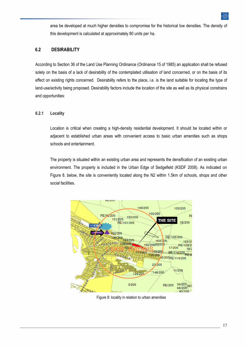
6.2.1 Locality
Location is critical when creating a high-density residential development. It should be located within or
adjacent to established urban areas with convenient access to basic urban amenities such as shops
schools and entertainment.
The property is situated within an existing urban area and represents the densification of an existing urban
environment. The property is included in the Urban Edge of Sedgefield (KSDF 2008). As indicated on
Figure 8. below, the site is conveniently located along the N2 within 1.5km of schools, shops and other
social facilities.
CBD
Figure 8: locality in relation to urban amenities
CBD
SCHOOL
1.5KM RADIUS
18
6.2.2 Bio-Physical Site Characteristic
The biophysical character of the site has been carefully assessed and was taken into account during the
conceptual planning:
� The study area was formerly used for the cultivation of crops and as a pine plantation. These
agricultural activities caused total destruction of the natural vegetation on site;
� The site does not contain any natural vegetation and has been earmarked for development. The
conservation value of the development area can be described as poor;
� The property is suitable for development in terms of gradient (slopes not steeper than 1:4);
� The development area has suitable access through an existing road network;
� The property is an unutilised piece of land within the urban area of Sedgefield.
� The development is already supplied with the required infrastructure.
It can be concluded that the site has limited constraints which classify this site as highly desirable for
development.
6.3 URBAN CONTEXT
Urban context concerns the broader setting of a development – including its existing physical surroundings, its
social and economic environment, and a strategic view of the area in which it is located and its role over time. All
new developments should make a positive contribution to an area's character, protecting and contributing to its
valued natural, built and community qualities.
The introduction of higher densities implies a change in the urban context. It is inevitable that components of any
new development would ‘spill over’ or have an impact on areas external to the project. This external impact could be
either beneficial or detrimental.
6.3.1 Strategic View of the Area
There are a number of forward planning documents that set out the strategic view of the area. The most
important of those are the Provincial SDF and the Knysna SDF.
6.3.1.1 Provincial Spatial Development Framework (2009)
The PSDF is a policy document that will be applied in terms of the conformity principle; it does not create
or take away any rights to use land, but upgrading of existing rights will have to conform to the policies
contained in the PSDF.
19
The policies are grouped according to 3 prime objectives:
• Socio-economic Development
• Urban Restructuring
• Environmental Sustainability
We submit that the planned development conform with the prime objectives of the PSDF.
• Socio-economic Development
The development will create opportunity for people that could previously not afford to own their
own homes to enter the property market. The goal of this rezoning is to adapt the residential
properties currently offered in terms of the approved lower density zoning, to cater for a higher
density, middle income market which is currently more in demand on properties such as the
Aviemore property. This higher density residential development will promote sustainable
development and it will offer an affordable and high quality environment to the lower middle income
market segment for which there is currently a definite need in the Sedgefield area.
Ownership engenders a sense of pride in their homes, streets and areas and advances the social
development of the entire community.
This development and other similar developments will also play a major role in the economic
prosperity of the region. The local economy of Sedgefield is very small and is dependent on trade
and retail activities. The local population will benefit greatly from any new job creation activities and
the increased buying power that the resident of the estate will create.
• Urban Restructuring
The overarching objective of densification and infill development is restructuring and integrating the
existing inequitable urban system created during the separatist apartheid era. The proposed higher
density and more affordable development will promote the integration of various socio economic
groups and thereby eventually assist in the restructuring of the town.
• Environmental Sustainability
The role of urban densification and infill is to minimise the consumption of scarce environmental
resources such as agricultural land or conservation worthy natural areas. The densification of
20
existing urban areas protects the surrounding natural and agricultural resources from further
development pressure.
6.3.1.2 Knysna Spatial Development Framework November 2008 ( KSDF)
The Knysna SDF has identified Sedgefield as a secondary node, or a second order settlement in the
context of the Municipality, making it the most significant ‘small town’. Although its roots as a holiday
destination remain important, the SDF recognise the need to create employment opportunities, specifically
in its historically disadvantaged communities.
The Knysna SDF acknowledges that there is very limited opportunity for urban expansion in Sedgefield.
The need to accommodate future growth can only be addressed through the redevelopment of existing
urban land.
The SDF recommends that growth and investment in Sedgefield should be focussed on developing its role
as:
� A major tourist and holiday destination;
� A secondary, yet important centre for administrative and public services functions;
� A location for limited low income / affordable housing provision;
� Job creation and socio-economic development of the poorest groups of its population;
� Significant investment in the tourism and related industry.
The planned development will be able to contribute toward achieving these goals. The aim of the
development is to provide affordable housing in Sedgefield for locals and tourists.
In accordance with the Provincial Urban Edge Guidelines, the urban edge around Sedgefield basically
follows the existing urban fabric. There is very little room for urban expansion in Sedgefield, primarily as a
result of the surrounding sensitive natural features (dunes, wetlands, estuaries etc.). The SDF document
clearly states that development should be limited to urban densification and infill areas. Densification is
strongly encouraged in urban areas throughout the municipality, specifically along activity streets and
around urban nodes.
21
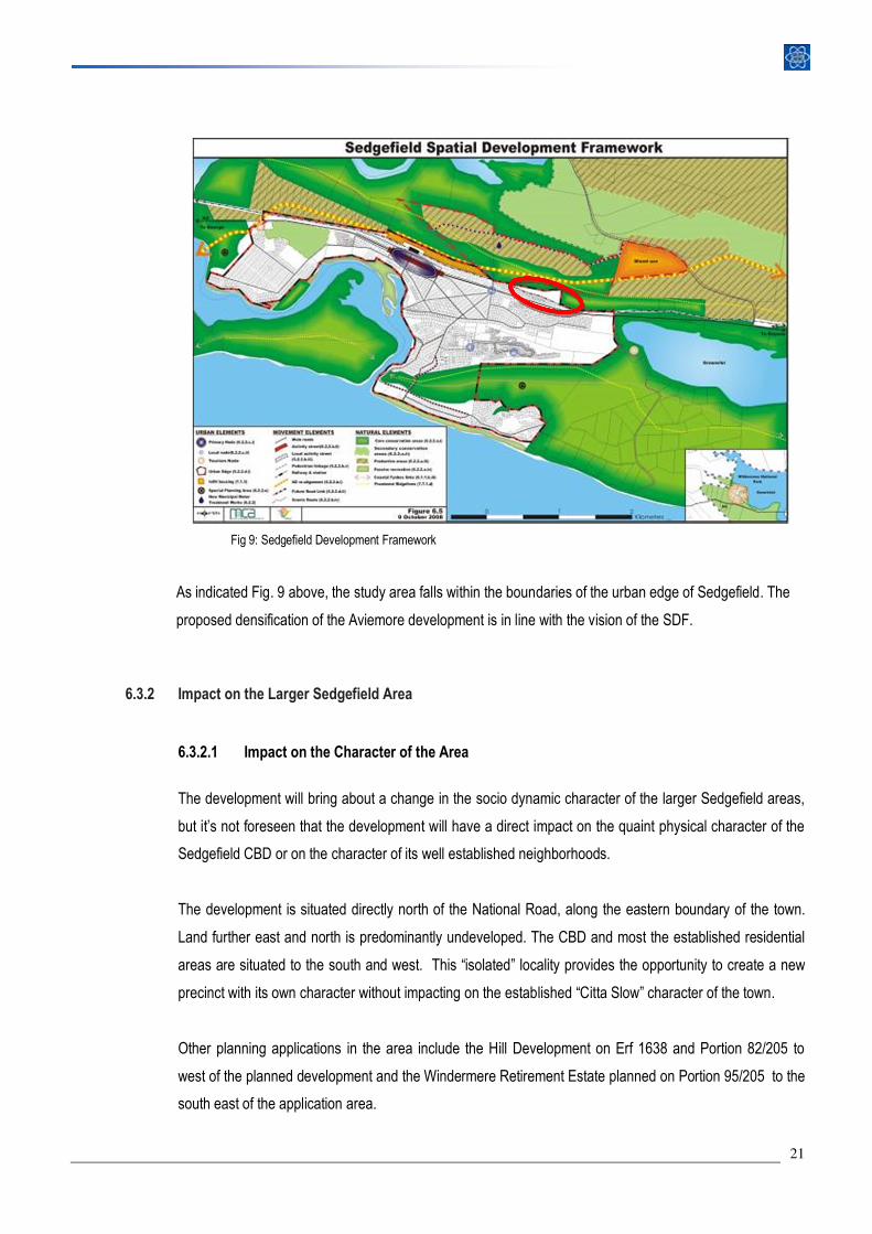
Fig 9: Sedgefield Development Framework
As indicated Fig. 9 above, the study area falls within the boundaries of the urban edge of Sedgefield. The
proposed densification of the Aviemore development is in line with the vision of the SDF.
6.3.2 Impact on the Larger Sedgefield Area
6.3.2.1 Impact on the Character of the Area
The development will bring about a change in the socio dynamic character of the larger Sedgefield areas,
but it’s not foreseen that the development will have a direct impact on the quaint physical character of the
Sedgefield CBD or on the character of its well established neighborhoods.
The development is situated directly north of the National Road, along the eastern boundary of the town.
Land further east and north is predominantly undeveloped. The CBD and most the established residential
areas are situated to the south and west. This “isolated” locality provides the opportunity to create a new
precinct with its own character without impacting on the established “Citta Slow” character of the town.
Other planning applications in the area include the Hill Development on Erf 1638 and Portion 82/205 to
west of the planned development and the Windermere Retirement Estate planned on Portion 95/205 to the
south east of the application area.
22
6.3.2.2 Socio-Economic Impact
The development will have a positive socio economic impact. The development will be implemented in
phases so it is therefore anticipated that there will be a relatively long construction period that will provide
temporary employment to many locals. The development will also address the shortage in more affordable
housing which will give individuals and families the opportunities to upgrade their living conditions. In
addition the development is expected to increase the buying power of the town and this economic benefit
will improve the sustainability of many struggling local businesses.
6.3.2.3 Visual Impact
One of the objectives of the Provincial Spatial Development Framework is to conserve and strengthen the
sense of place of important natural, cultural and productive landscapes, artifacts and buildings. In this
case, the scenic quality of the landscape visible from the N2 (Garden Route), need to be protected by a
Visual Resource Management Plan.
The proposed development will be visible from the N2. Bearing in mind that the property is within the
urban area and that it does have established development rights, the expected visual impact will be low.
The visibility and visual impact of the development does not necessarily need to be a negative impact.
Architecturally designed units with earthy tones will blend in with the planned landscape plans and could
create a positive feeling of well-being and prosperity to people passing through Sedgefield. The current
partially developed estate does not inspire any confidence and is certainly not visually pleasing. Especially
if one considers the fact that the Aviemore Development represents the northern segment of the “eastern
Gate Way” in to Sedgefield along the N2/Garden Route.
The buildings will be 3 storey’s high, which will increase the visual impact. The buildings are however set
against the back drop of a vegetated hill which will reduce the impact significantly. It is also the intention to
landscape along the N2, not only to reduce the noise factor associated with the highway, but also to reduce
the visibility of the estate. The height of the planned buildings will not impact on any other properties’ view.
The property to the north is undeveloped and consists of a cemetery and a rehabilitated garden refuse
dump. This property also belongs to the developer.
6.3.2.4 Traffic impact
Road access will be provided via the existing road network, which will be upgraded . The Traffic Impact
study conducted by the Checkers group proposed that the Egret Street /N2 intersection be upgraded and
supplied with traffic signals. The traffic study conducted by the planned development on The Hill also
recommended the signaling of this intersection. Traffic signals will enhance the safety of this intersection
23
and will assist in reducing speed of through traffic on this road before it enters the buildup area of the CBD.
The construction of a traffic circle is also being considered. The cost of these upgrades will have to be
shared among all the road users.
6.3.2.5 Impact on Biodiversity
The recently released GRI maps identify the property as highly degraded (See Diagram 4: Critical
Biodiversity Map). The subject properties have not been listed as a Critical Biodiversity area, Ecological
support area or a Protected area. Due to the high occurrence of alien vegetation the potential negative
impact on biodiversity will be negligible. The concentration of development further inland will result in more
people being able to enjoy the amenities of the coastal town and nearby beaches without directly
impacting on the sensitive coastline as oppose to continual ribbon development along the coast. In this
sense the development will have a positive impact on biodiversity as it will reduce development pressure in
more sensitive areas.
6.3.3 Impact on the Aviemore Estate
The Home Owners Association has been involved in the planning of the densification. A letter of support
received from the Aviemore Home Owners Association is attached as “Annexure H”
The expected negative impact on the existing estate will be mainly due to increased traffic and noise,
especially during the construction phase. To reduce the impact on the existing resident, an alternative
construction access road that bypasses the existing development is proposed.
The high density development will also be separated from the existing residents by the implementing
several rows of trees and a 2m high wall. The planned communal facilities will also create a transitional
area between phase 1 and phase 2.
The successful implementation of the planned development will enable the developer to generate capital
that will assist with the construction of an attractive gate house and with the implementation of screening
and landscaping along the N2. If well planned and managed, the proposed densification will also
contribute to decreased levies of the larger estate, due to more people contributing to operational and
maintenance cost of the estate.
The existing owners will further more be able to make use of the planned facilities (i.e. swimming pool/
tennis court/braai areas).
24
Presently the undeveloped open area is a security risk to the few residents of the estate. Although the
property is fenced, the large overgrown eastern section is difficult to police and maintain. The development
of this area will enhance the security of the estate.
7. CONCLUSION
Application is made for the rezoning of Erf 3550 - 3587 from “Group Housing” to “General Residential” to allow the
densification of the existing Aviemore Development. This application aims to balance the need to accommodate larger
numbers of additional people within the urban area and simultaneously achieving a satisfactory living environment, and
ensuring affordable costs.
This site, with its close proximity to town, affords a once-off opportunity to provide affordable middle-income housing in a
well-designed secure environment. The densification proposal will allow the critical mass necessary for the development to
be financially feasible, by ensuring the optimal use of the available land and infrastructure.
The development of the property is in line with densification policies currently being promoted at National, Provincial and
Local levels. It is concluded that the proposed densification of the Aviemore Estate is sensitive towards the surrounding
environment and will contribute significantly towards the socio economic up-liftment of the area.