Embed Size (px)
Citation preview
Morena Corridor Specific Plan

This page is intentionally left blank.
Morena Corridor Specific PlanPublic Review Draft - June 2017
Prepared for:
Prepared by:

This page is intentionally left blank.
i
ACKNOWLEDGMENTS
MAYOR
Kevin Faulconer
CITY ATTORNEY
Mara Elliott, City AttorneyHeidi Vonblum, Deputy City Attorney
CITY COUNCIL
Barbara Bry, District 1Lorie Zapf, District 2Chris Ward, District 3Myrtle Cole, District 4Mark Kersey, District 5Chris Cate, District 6Scott Sherman, District 7David Alvarez, District 8Georgette Gomez, District 9
PLANNING COMMISSION
Stephen Haase, ChairpersonSusan Peerson, Vice ChairpersonDouglas AustinWilliam Hofman Vickie GranowitzDennis OtsujiJames Whalen
CITY STAFF
Jeff Murphy, DirectorTom Tomlinson, Assistant Director Alyssa Muto, Deputy DirectorTait Galloway, Program ManagerMichael Prinz, Senior Planner/Project ManagerSamir Hajjiri, Senior Traffic EngineerRaynard Abalos, Senior PlannerRobin Shifflet, Development Project Manager Rebecca Malone, Senior Planner Claudia Brizuela, Associate Traffic EngineerBobby Mordenti, Associate PlannerVickie White, Senior PlannerElizabeth Ocampo, Associate PlannerBernie Turgeon, Senior PlannerSara Osborn, Senior PlannerMichael Klein, Information System AnalystLeo DeJesus, Mapping Technician
CLAIREMONT COMMUNITY PLANNING GROUP SUBCOMMITTEE
Margaret Schmidt, chairLynne AdamsNaveen WaneyCece FrankHarry BackerDave Potter James LaMattery John Shannon Carol SchleismanLINDA VISTA PLANNING GROUP SUBCOMMITTEE
Howard Wayne, ChairMargarita CastroKimberly WeberMark SukenikRolando OgotVirgina Mergener
ii
Morena Corridor Specific Plan
TABLE OF CONTENTS
Chapter 1 | Introduction ........................................................................................................................ 1
1.1 - Overview .......................................................................................................................................................11.2 - Vision .............................................................................................................................................................11.3 - Guiding Principles ........................................................................................................................................21.4 - Specific Plan Area ........................................................................................................................................31.5 - Relationship to Other Planning Documents ............................................................................................31.6 - Planning Process .........................................................................................................................................5
Chapter 2 | Land Use .............................................................................................................................. 7
2.1 - Land Use Designations ...............................................................................................................................72.2 - Planning Districts .......................................................................................................................................232.3 - Tecolote Village District ............................................................................................................................242.4 - Morena Village District .............................................................................................................................282.5 - Employment District .................................................................................................................................322.6 - Artisan District ...........................................................................................................................................332.7 - Clairemont District ....................................................................................................................................34
Chapter 3 | Mobility .............................................................................................................................. 35
3.1 - Mobility Improvements.............................................................................................................................373.2 - Walkability ..................................................................................................................................................473.3 - Bicycling ......................................................................................................................................................483.4 - Transit Service ............................................................................................................................................503.5 - Vehicular Mobility ......................................................................................................................................50 Chapter 4 | Urban Design ..................................................................................................................... 53
4.1 - Urban Design Framework ........................................................................................................................534.2 - Streetscape and Public Realm .................................................................................................................564.3 - Branding and Gateways ............................................................................................................................604.4 - Development Design .................................................................................................................................634.4 - Sustainable Design ....................................................................................................................................67
iii
Morena Corridor Specific Plan
5 | Recreation ......................................................................................................................................... 69
5.1 - Park Opportunities ....................................................................................................................................69
6 | Conservation .................................................................................................................................... 71
6.1 - Sustainable Development ........................................................................................................................72 6.2 - Urban Runoff Management .....................................................................................................................75
7 | Infrastructure Public Facilities and Services ................................................................................ 77
7.1 - Water ...........................................................................................................................................................777.2 - Wastewater ................................................................................................................................................787.3 - Stormwater.................................................................................................................................................787.4 - Dry Utilities .................................................................................................................................................797.5 - Public Facilities ...........................................................................................................................................79
8 | Implementation ............................................................................................................................... 81
8.1 - Purpose .......................................................................................................................................................818.2 - Severability .................................................................................................................................................818.3 - Administration ...........................................................................................................................................828.4 - Environmental Review ..............................................................................................................................828.5 - Land Development Code ..........................................................................................................................828.6 - Supplemental Development Regulations ...............................................................................................838.7 - Affordable Housing Density Bonus Regulations ....................................................................................858.8 - Specific Plan Amendments .......................................................................................................................858.9 Implementation Action Plan .......................................................................................................................85
iv
Morena Corridor Specific PlanMorena Corridor Specific Plan
LIST OF TABLES
Table 2-1 - Land Use Designations ....................................................................................................................9Table 8-1 - Summary of Mobility Improvements ...........................................................................................79
LIST OF FIGURES
Figure 1-1 - Location of Specific Plan Area ........................................................................................................4Figure 2-1 - Specific Plan Land Use Map ...........................................................................................................8Figure 2-2 - Planning Districts ...........................................................................................................................23Figure 2-3 - Tecolote Village District ................................................................................................................24Figure 2-4 - Illustrative Site Plan of Tecolote Village District .........................................................................26Figure 2-5 - Illustrative of Example Development in Tecolote Village District ............................................27Figure 2-6 - Morena Village District ..................................................................................................................28Figure 2-7 - Illustrative of Example Development in Morena Village District .............................................31Figure 2-8 - Employment District .....................................................................................................................32Figure 2-9 - Artisan District ...............................................................................................................................33Figure 2-10 - Clairemont District ......................................................................................................................34Figure 3-1 - Location of Proposed Mobility Network Improvements ..........................................................36Figure 3-2 - Proposed Cross Section for Improvement 1 ..............................................................................37Figure 3-3 - Proposed Intersection Conceptual Design for Improvement 2 ...............................................38Figure 3-4 - Proposed Intersection Conceptual Design for Improvement 3 ...............................................39Figure 3-5 - Proposed Cross Section for Improvement 4 ..............................................................................39Figure 3-6 - Proposed Cross Section for Improvement 5 ..............................................................................40Figure 3-7 - Proposed Intersection Conceptual Design for Improvement 6 ...............................................40Figure 3-8 - Proposed Intersection Conceptual Design for Improvement 7 ...............................................41Figure 3-9 - Proposed Cross Section for Improvement 8 ..............................................................................42Figure 3-10 - Proposed Intersection Conceptual Design for Improvement 8 ............................................42Figure 3-11 - Proposed Intersection Conceptual Design for Improvement 9 ............................................43Figure 3-12 - Proposed Intersection Conceptual Design for Improvement 10 ..........................................43Figure 3-13 - Location of Proposed Bicycle Network Improvements ..........................................................49Figure 3-14 - Existing Functional Roadway Classifications ............................................................................51Figure 3-15 - Future Functional Roadway Classifications .............................................................................52Figure 4-1 - Urban Design Framework Map ...................................................................................................55Figure 4-2 - Conceptual Gateway Sign Locations ...........................................................................................61Figure 5-1 - Illustrative Drawing of Tecolote Linear Park in Artisan District ...............................................69Figure 7-1 - Morena Corridor Districts Map ....................................................................................................77
1
Morena Corridor Specific Plan Chapter 1 - IntroductionMorena Corridor Specific Plan
1.1. OVERVIEW
1 |Introduction
The Morena Corridor Specific Plan envisions the transformation of an auto-oriented commercial corridor into a pedestrian-oriented village with mixed-use and employment adajcent to trolley stations. The Specific Plan will help implement the goals of the City’s General Plan and Climate Action Plan by increasing employment and housing opportunities near transit, promoting walking and bicycle use as viable travel choices, and improving transit access and frequency. The Specific Plan envisions a mix of employment, retail and residential uses near high frequency transit and linked by pedestrian and bicycle facilities.
The Specific Plan contains policies and supplemental development regulations for development within the specific plan area, which is located on the western edge of the communities of Clairemont Mesa and Linda Vista. Properties located within Clairemont Mesa are not subject to the Specific Plan supplemental development regulations. The policies provide direction on the qualitative aspects for development and the flexibility necessary to encourage creative design. Photographs depict concepts related to building elements and site design rather than a specific architectural theme or style. The Specific Plan identifies mobility, streetscape, and public realm improvements and facility recommendations.
The City prepared a previous planning study of the areas adjacent to the future trolley stations at Tecolote Road and Clairemont Drive and the existing Morena station. The planning study included recommendations to focus development within the station areas; identified a modified grid network within Linda Vista; and additional mobility improvements that would enhance access and safety for bicyclists, pedestrians, vehicles, and transit users. The Specific Plan builds upon and refines the technical analysis, recommendations, and public input from the planning study.
1.2. VISION
Enhance the Morena corridor as a mixed-use village that has a vibrant community core with a strong restaurant/retail component and gathering places, balanced residential density that includes affordable housing, quality urban design, safe and accessible travel for all modes, employment opportunities, adequate infrastructure, and public amenities.
2
Morena Corridor Specific PlanChapter 1 - Introduction
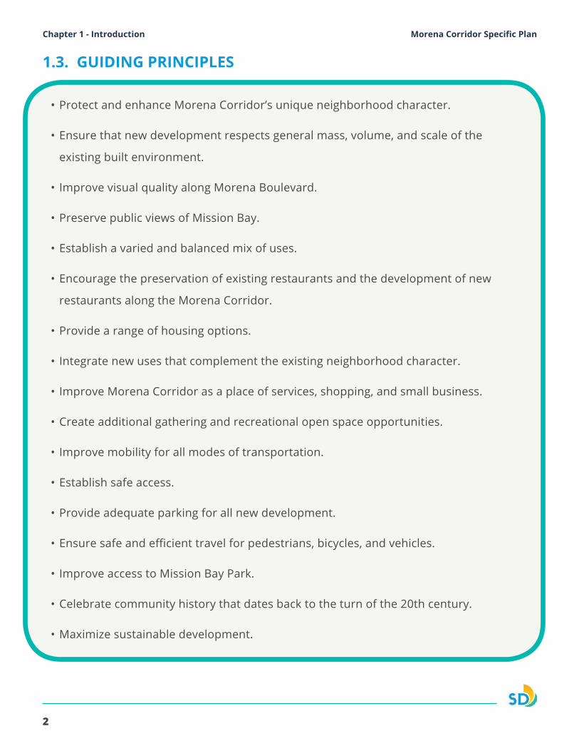
• Protect and enhance Morena Corridor’s unique neighborhood character.
• Ensure that new development respects general mass, volume, and scale of the
existing built environment.
• Improve visual quality along Morena Boulevard.
• Preserve public views of Mission Bay.
• Establish a varied and balanced mix of uses.
• Encourage the preservation of existing restaurants and the development of new
restaurants along the Morena Corridor.
• Provide a range of housing options.
• Integrate new uses that complement the existing neighborhood character.
• Improve Morena Corridor as a place of services, shopping, and small business.
• Create additional gathering and recreational open space opportunities.
• Improve mobility for all modes of transportation.
• Establish safe access.
• Provide adequate parking for all new development.
• Ensure safe and efficient travel for pedestrians, bicycles, and vehicles.
• Improve access to Mission Bay Park.
• Celebrate community history that dates back to the turn of the 20th century.
• Maximize sustainable development.
1.3. GUIDING PRINCIPLES
3
Morena Corridor Specific Plan Chapter 1 - Introduction
1.4. SPECIFIC PLAN AREA
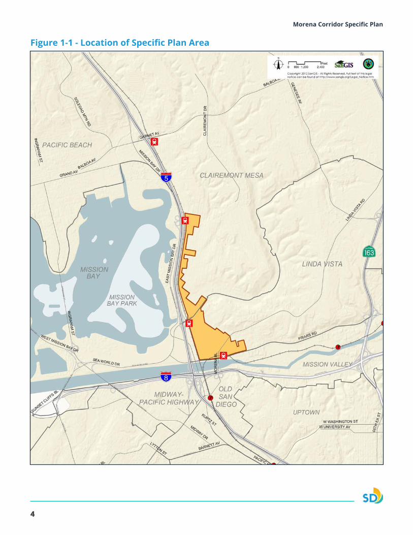
The Specific Plan area is approximately 300 acres along Morena Boulevard and West Morena Boulevard between Clairemont Drive and Friars Road. This area is within the Clairemont Mesa Community Plan Area and the Linda Vista Community Plan Area, as shown on Figure 1-1.
To the west, the Specific Plan area is bounded by the railroad right-of-way and Interstate 5 (I-5), which separate the community from Mission Bay. To the north and east, the Specific Plan area is shaped by the sloping topography and cohesive single-family residential neighborhoods in Clairemont Mesa, and the University of San Diego (USD) and multifamily and student housing in Linda Vista. To the south is the San Diego River and Interstate 8 (I-8), which separate the Specific Plan area from Old Town San Diego and Downtown San Diego.
The San Diego Trolley connects Downtown San Diego to the University of California, San Diego and University Towne Center, along the west side of Morena Boulevard. The Specific Plan area includes the Morena/Linda Vista Trolley Station at Morena Boulevard and Linda Vista Road, West Morena Boulevard at Tecolote Road, and Morena Boulevard at Clairemont Drive as shown on Figure 1-1.
1.5. RELATIONSHIP TO OTHER PLANNING DOCUMENTS
General Plan
The General Plan expresses a Citywide vision and provides a comprehensive policy framework for how the City should grow and develop. The Specific Plan is consistent with, and furthers the goals and policies of the General Plan by providing detailed criteria for development of a mixed-use “village” as part of the “City of Villages Strategy.” The Specific Plan conforms with the General Plan and guides land use, circulation, and infrastructure improvements in the Specific Plan area.
Clairemont Mesa and Linda Vista Community Plans
The Clairemont Mesa and Linda Vista Community Plans are part of the Land Use Element of the General Plan. Community plans provide more detailed land use designations than the General Plan and provide community-specific policy recommendations. The community plans also provide the basis for zoning. The General Plan and Community Plans work together to establish the framework for growth and development.
The Specific Plan is consistent with, and furthers the goals and policies of the General Plan and community plans by allowing for development of mixed-use transit-oriented “villages” within the “City of Villages Strategy.” The Specific Plan implements the General Plan and guides land use, circulation, and infrastructure improvements in the Specific Plan area.
4
Morena Corridor Specific Plan
Figure 1-1 - Location of Specific Plan Area
5
Morena Corridor Specific Plan Chapter 1 - Introduction
Climate Action Plan (CAP)
The CAP is intended to ensure the City achieves State mandates for greenhouse gas (GHG) reductions through local action. The CAP identifies five primary strategies implemented by a number of actions to meet the GHG reduction target for 2020 as well as an interim target set for 2035 that is on the trajectory to a 2050 statewide goal. One of the five primary strategies identified in the CAP is to implement mobility and land use strategies that promote increased capacity for transit-supportive residential and employment densities, and provide more walking and biking opportunities. These concepts are consistent with the General Plan, and include a focus on increased capacity in Transit Priority Areas (TPAs); areas within one-half mile from a major transit stop. Portions of the Specific Plan area are within a TPA, and the Specific Plan increases housing and employment adjacent to the trolley stations, and provides mobility recommendations to improve pedestrian and bicycle connectivity consistent with the CAP land use and mobility strategies.
Morena Corridor Specific Plan Environmental Impact Report
The Environmental Impact Report (EIR) for the Morena Corridor is a comprehensive assessment of the environmental effects that could result from implementation of the proposed Specific Plan. The EIR for the Specific Plan complies with the California Environmental Quality Act (CEQA). In addition to addressing potential impacts related to community concerns such as aesthetics, air quality, traffic, and infrastructure, the EIR identifies mitigation to reduce or avoid significant impacts.
1.6. PLANNING PROCESS
The Specific Plan has been developed through a community outreach process that included online and in-person forums. Specifically, the public outreach for the Specific Plan was primarily conducted through the Morena Corridor subcommittees of the Clairemont Mesa and Linda Vista Community Planning Groups. The community outreach was a collaborative process between community members and the City, with the participation strategy designed to:
• Provide multiple venues for participation.
• Solicit input, ideas and feedback.
• Share process information.
• Report to the community planning group on decisions made at key stages of the planning process.
• Engage the diversity of people, perspectives, and priorities in the Clairemont Mesa and Linda Vista communities.
6
Morena Corridor Specific PlanMorena Corridor Specific Plan
This page is intentionally left blank.
7
Morena Corridor Specific Plan Chapter 2 - Land UseMorena Corridor Specific Plan
The land use chapter establishes land use and districts to guide development and integrate a mix of uses, primarily focused around nodes of activity, to promote a thriving, mixed-use environment.
2.1. LAND USE DESIGNATIONS
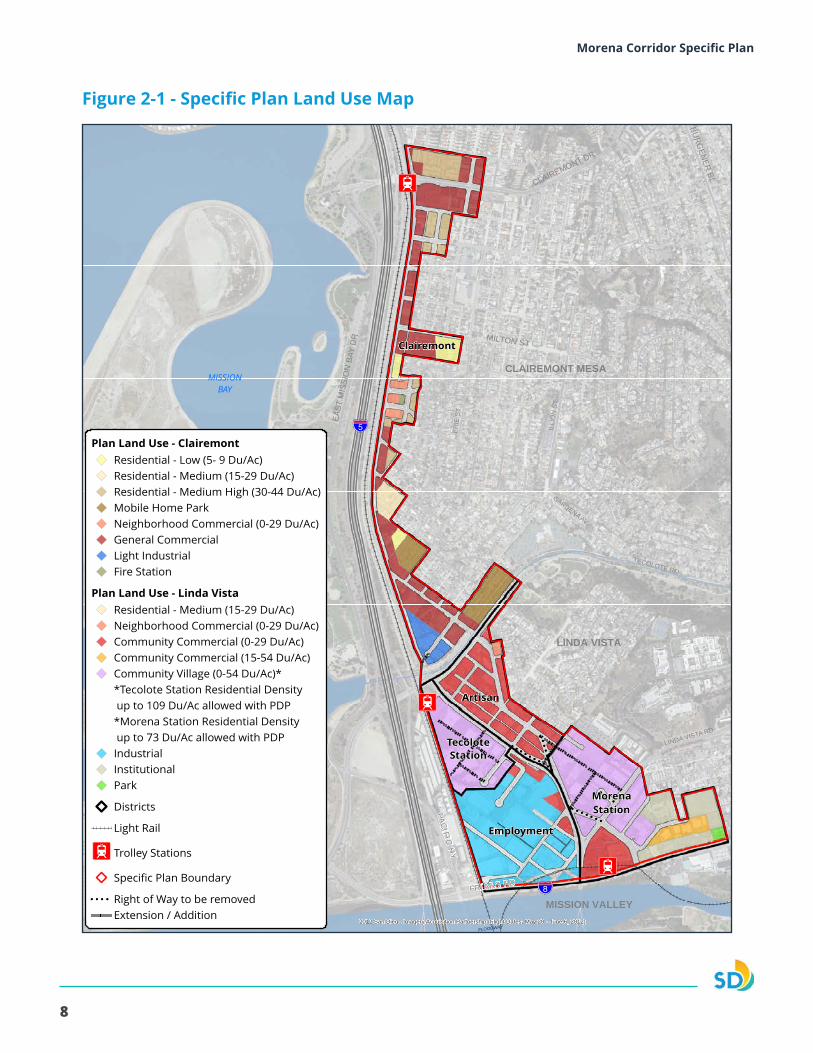
The land use designations within the Specific Plan area are shown in Figure 2-1 and summarized in Table 2-1.
LAND USE AND DISTRICTS GOALS
• A distinct identity through a cohesive mix of uses.
• A diverse mix of land uses surrounding the transit stations.
• Connections to transit through a modified grid street network.
• Economic vitality through a mix of employment uses.
• A vibrant retail and restaurant sector.
2 |Land Use and Districts
8
Morena Corridor Specific Plan
!! !!!!
!!!!
!!
!!!!
!!!!
!!!!
!!!!
!!!!
!!
!!!!
!!!!
!!
!!
!!!!
!!!!
!!!!
!!!!
I2
I2
I2
MISSIONBAY
!"̂$
SAN DIEGO RIVER
FLOODWAY
!"_$
GARDENA AV
TECOLOTE RD
ILLI
ON
ST
LINDA VISTA RD
ERIE
ST
BURG
ENER
BL
MILTON ST
FRIARS RD
EAST
MIS
SIO
N B
AY D
R
SEA WORLD DR
PACIFIC HY
CLAIREMONT DR
Clairemont
MorenaStation
Artisan
Employment
TecoloteStation
MISSION BAY PARK
CLAIREMONT MESA
LINDA VISTA
MISSION VALLEY2012 San Diego Imagery Acquisition Partnership (Flight Dates: May 20 - June 6, 2012)
THIS MAP IS PROVIDED WITHOUT WARRANTY OF ANY KIND, EITHER EXPRESS OR IMPLIED, INCLUDING BUT NOT LIMITED TO, THE IMPLIED WARRANTIES OF MERCHANTABILITY AND FITNESS, FOR A PARTICULAR PURPOSE. Copyright SanGIS. All Rights Reserved. This product may contain information from the SANDAG Regional Information System which cannot be reproduced without written permission of SANDAG. This product may contain information which has been reproduced with permission granted by Thomas Bros. Maps.
Plan Land Use - ClairemontResidential - Low (5- 9 Du/Ac)Residential - Medium (15-29 Du/Ac)Residential - Medium High (30-44 Du/Ac)Mobile Home ParkNeighborhood Commercial (0-29 Du/Ac)General CommercialLight IndustrialFire Station
Plan Land Use - Linda VistaResidential - Medium (15-29 Du/Ac)Neighborhood Commercial (0-29 Du/Ac)Community Commercial (0-29 Du/Ac)Community Commercial (15-54 Du/Ac)Community Village (0-54 Du/Ac)**Tecolote Station Residential Density up to 109 Du/Ac allowed with PDP*Morena Station Residential Density up to 73 Du/Ac allowed with PDPIndustrialInstitutionalPark
Districts
Light Rail
I2 Trolley Stations
Specific Plan Boundary
!! !! !! !! Right of Way to be removedExtension / Addition
Morena Corridor Specific Plan
600 0 600300
Feet
Date: 6/15/2017Document Path: L:\GIS\PGIS\Smart Growth Grants\MorenaBlvd\MXD\Smart_Growth_Morena_Proposed_LandUse_wDistricts_April2017.mxd
Figure 2-1 Plan Land Use Map with Districts
ATTACHMENT 1Figure 2-1 - Specific Plan Land Use Map
9
Morena Corridor Specific Plan Chapter 2 - Land Use
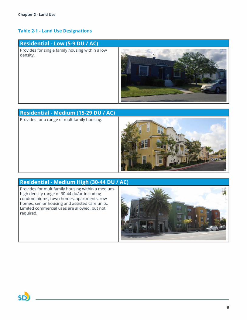
Table 2-1 - Land Use Designations
Residential - Low (5-9 DU / AC)Provides for single family housing within a low density.
Residential - Medium (15-29 DU / AC)Provides for a range of multifamily housing.
Residential - Medium High (30-44 DU / AC)Provides for multifamily housing within a medium-high density range of 30-44 du/ac including condominiums, town homes, apartments, row homes, senior housing and assisted care units. Limited commercial uses are allowed, but not required.
20
Morena Corridor Specific Plan
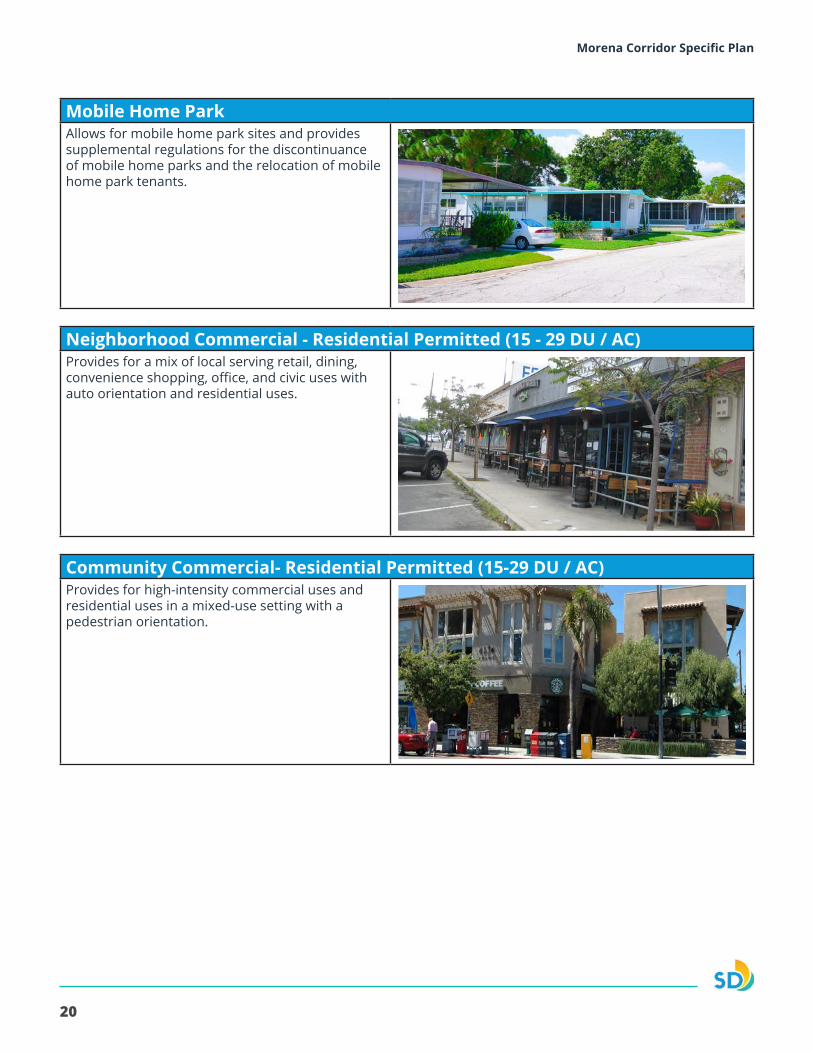
Mobile Home ParkAllows for mobile home park sites and provides supplemental regulations for the discontinuance of mobile home parks and the relocation of mobile home park tenants.
Neighborhood Commercial - Residential Permitted (15 - 29 DU / AC)Provides for a mix of local serving retail, dining, convenience shopping, office, and civic uses with auto orientation and residential uses.
Community Commercial- Residential Permitted (15-29 DU / AC)Provides for high-intensity commercial uses and residential uses in a mixed-use setting with a pedestrian orientation.
21
Morena Corridor Specific Plan Chapter 2 - Land Use
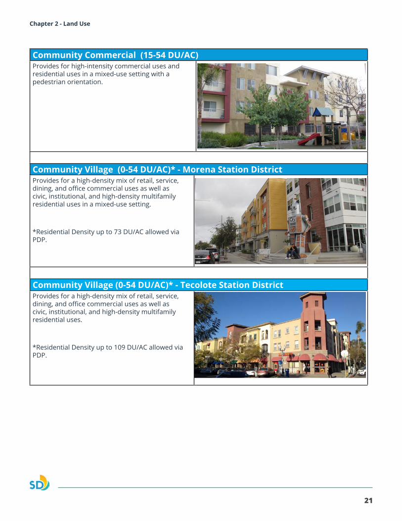
Community Commercial (15-54 DU/AC)Provides for high-intensity commercial uses and residential uses in a mixed-use setting with a pedestrian orientation.
Community Village (0-54 DU/AC)* - Morena Station DistrictProvides for a high-density mix of retail, service, dining, and office commercial uses as well as civic, institutional, and high-density multifamily residential uses in a mixed-use setting.
*Residential Density up to 73 DU/AC allowed via PDP.
Community Village (0-54 DU/AC)* - Tecolote Station DistrictProvides for a high-density mix of retail, service, dining, and office commercial uses as well as civic, institutional, and high-density multifamily residential uses.
*Residential Density up to 109 DU/AC allowed via PDP.
22
Morena Corridor Specific Plan
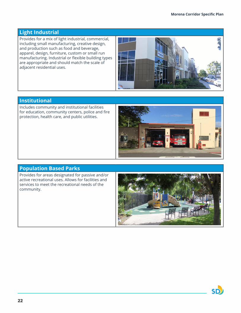
Light IndustrialProvides for a mix of light industrial, commercial, including small manufacturing, creative design, and production such as food and beverage, apparel, design, furniture, custom or small run manufacturing. Industrial or flexible building types are appropriate and should match the scale of adjacent residential uses.
Institutional Includes community and institutional facilities for education, community centers, police and fire protection, health care, and public utilities.
Population Based ParksProvides for areas designated for passive and/or active recreational uses. Allows for facilities and services to meet the recreational needs of the community.
23
Morena Corridor Specific Plan Chapter 2 - Land Use
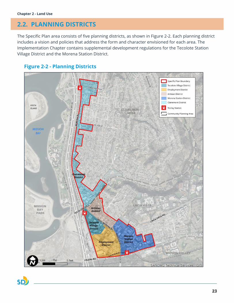
2.2. PLANNING DISTRICTS
The Specific Plan area consists of five planning districts, as shown in Figure 2-2. Each planning district includes a vision and policies that address the form and character envisioned for each area. The Implementation Chapter contains supplemental development regulations for the Tecolote Station Village District and the Morena Station District.
Figure 2-2 - Planning Districts

24
Morena Corridor Specific Plan
2.3. TECOLOTE VILLAGE DISTRICT
Figure 2-3 - Tecolote Village DistrictThe Specific Plan envisions the establishment of a community village as a vibrant, pedestrian- and transit-oriented entertainment area adjacent to the Tecolote Trolley Station (See Figure 2-3). The village will incorporate a mix of commercial, residential, and civic uses to activate the area. The West Morena Boulevard streetscape will create an inviting gateway to the village. The Tecolote Transit Station will be integrated into the village to create a strong transit link to serve employees and residents.
The integration of residential, retail, office, entertainment, and civic uses will provide activity and vitality to the village. Public and private streets and pedestrian and bicycle paths will break up the existing superblock to create a walkable block pattern while improving multi-modal access to the transit center and adjacent districts. Both West Morena and a primary village entrance street can provide neighborhood design elements with pedestrian-oriented retail uses for shopping and dining, and spaces for social interaction and gathering. Public parks, plazas or urban greens in the village will provide active and passive recreation opportunities. Refer to the Mobility, Urban Design, and Recreation Chapters for further direction.
Transit-Oriented Development Enhancement ProgramThe Transit-Oriented Development (TOD) Enhancement Program can be utilized within the Tecolote Station District, which is designated Community Village (54 Du/Ac) as shown on Figure 2-1. The intent of the TOD Enhancement Program is to allow for increased residential density to create transit-oriented development that supports the implementation of the CAP and implements the Mobility and Urban Design policies of the Specific Plan. The TOD Enhancement Program allows for the density range for this area to be increased up to 109 dwelling units per acre through a discretionary review process. The Program also allows for building height and floor area ratio increases as outlined in the Implementation Chapter. A project using the TOD Enhancement Program must be consistent with the Specific Plan Urban Design and Mobility policies and conform with the supplemental development regulations outlined in the Implementation Chapter.
25
Morena Corridor Specific Plan Chapter 2 - Land Use
PoliciesLand Use
2.3.1. Establish a pedestrian- and transit oriented development integrated with the Tecolote Transit Station to create a vibrant community village.
2.3.2. Provide a mix of entertainment, office, retail, residential, recreational, public and park uses.
2.3.3. Provide a range of housing opportunities, types, and affordability.
2.3.4. Provide a mix of service, retail, office, and entertainment uses to support residential uses and attract visitors and employment to the district.
2.3.5. Locate commercial uses between Buenos Avenue and Cudahy Place to serve as a buffer between residential development and the industrial uses in the adjcanet Employment District.
2.3.6. Allow for the calculation of residential density based on gross site area including any dedication of right-of-way on any site where new public streets, parks, or linear parks are planned or will be constructed.
Mobility
2.3.7. Incorporate a primary village entrance street or drive from West Morena Boulevard with pedestrian-oriented ground floor retail uses.
2.3.8. Incorporate new public streets or private drives, with pedestrian, and bicycle facilities to create a walkable scale for development.
2.3.9. Provide a system of interconnected pedestrian paths, paseos and sidewalks to provide enhanced connectivity to adjacent buildings and public space.
2.3.10. Support the use of shared structured parking between uses.
Public Space/Recreation
2.3.11. Provide a population-based park component to serve the needs of residential uses located within the village which can include a mini park, plazas or urban greens for active as well as passive recreation.
26
Morena Corridor Specific Plan
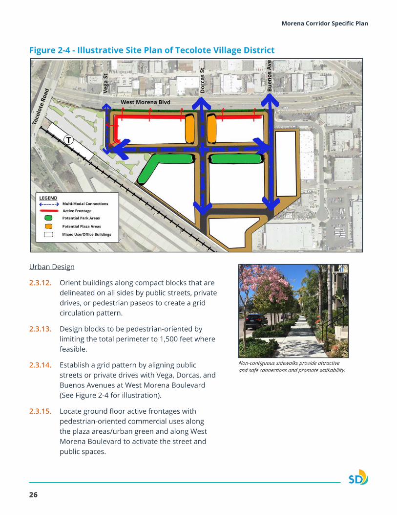
Figure 2-4 - Illustrative Site Plan of Tecolote Village District
Urban Design
2.3.12. Orient buildings along compact blocks that are delineated on all sides by public streets, private drives, or pedestrian paseos to create a grid circulation pattern.
2.3.13. Design blocks to be pedestrian-oriented by limiting the total perimeter to 1,500 feet where feasible.
2.3.14. Establish a grid pattern by aligning public streets or private drives with Vega, Dorcas, and Buenos Avenues at West Morena Boulevard (See Figure 2-4 for illustration).
2.3.15. Locate ground floor active frontages with pedestrian-oriented commercial uses along the plaza areas/urban green and along West Morena Boulevard to activate the street and public spaces.
Non-contiguous sidewalks provide attractive and safe connections and promote walkability.
27
Morena Corridor Specific Plan Chapter 2 - Land Use
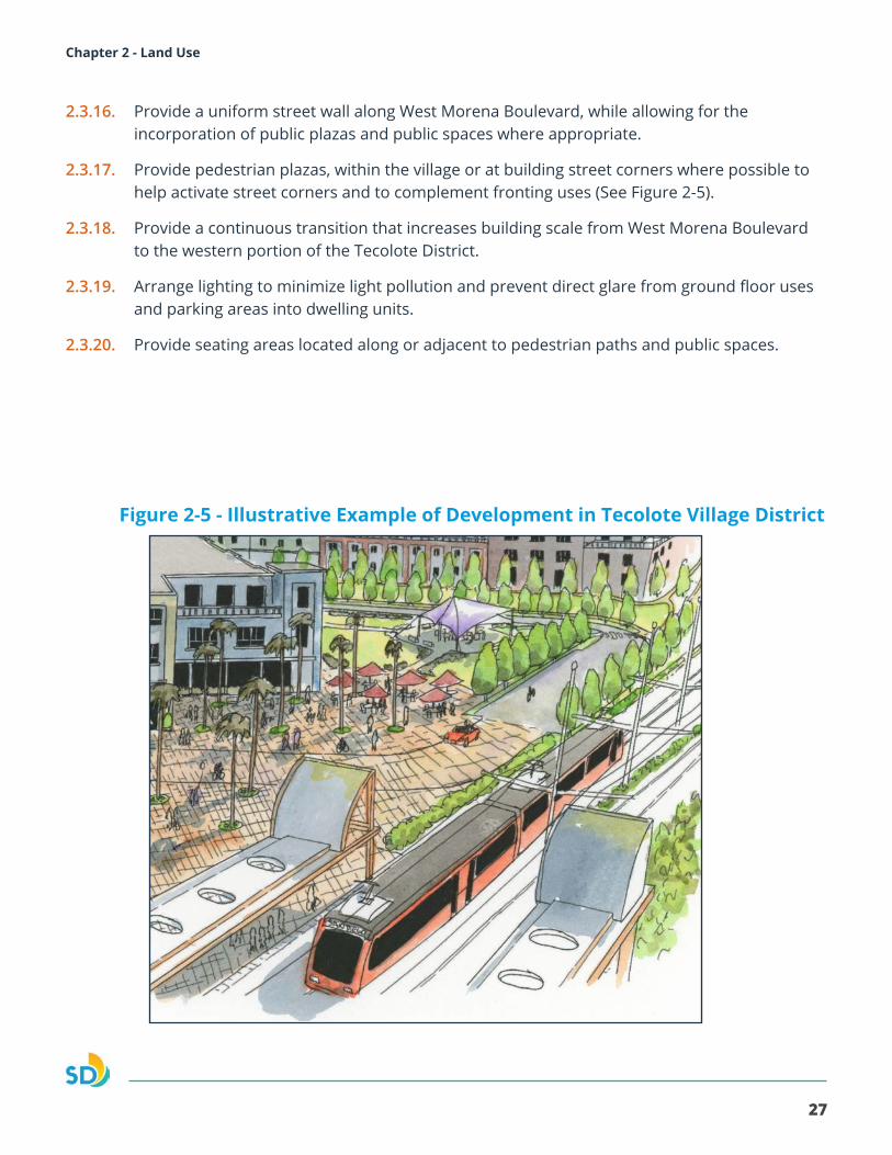
Figure 2-5 - Illustrative Example of Development in Tecolote Village District
2.3.16. Provide a uniform street wall along West Morena Boulevard, while allowing for the incorporation of public plazas and public spaces where appropriate.
2.3.17. Provide pedestrian plazas, within the village or at building street corners where possible to help activate street corners and to complement fronting uses (See Figure 2-5).
2.3.18. Provide a continuous transition that increases building scale from West Morena Boulevard to the western portion of the Tecolote District.
2.3.19. Arrange lighting to minimize light pollution and prevent direct glare from ground floor uses and parking areas into dwelling units.
2.3.20. Provide seating areas located along or adjacent to pedestrian paths and public spaces.
28
Morena Corridor Specific Plan
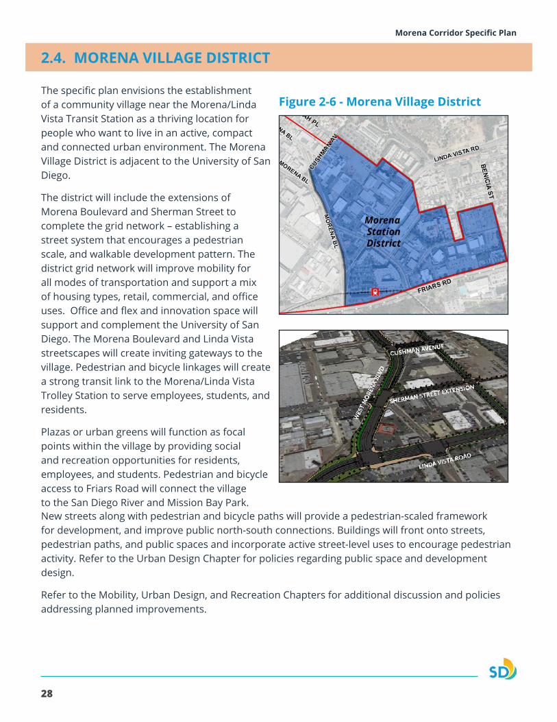
2.4. MORENA VILLAGE DISTRICT
Figure 2-6 - Morena Village DistrictThe specific plan envisions the establishment of a community village near the Morena/Linda Vista Transit Station as a thriving location for people who want to live in an active, compact and connected urban environment. The Morena Village District is adjacent to the University of San Diego.
The district will include the extensions of Morena Boulevard and Sherman Street to complete the grid network – establishing a street system that encourages a pedestrian scale, and walkable development pattern. The district grid network will improve mobility for all modes of transportation and support a mix of housing types, retail, commercial, and office uses. Office and flex and innovation space will support and complement the University of San Diego. The Morena Boulevard and Linda Vista streetscapes will create inviting gateways to the village. Pedestrian and bicycle linkages will create a strong transit link to the Morena/Linda Vista Trolley Station to serve employees, students, and residents.
Plazas or urban greens will function as focal points within the village by providing social and recreation opportunities for residents, employees, and students. Pedestrian and bicycle access to Friars Road will connect the village to the San Diego River and Mission Bay Park. New streets along with pedestrian and bicycle paths will provide a pedestrian-scaled framework for development, and improve public north-south connections. Buildings will front onto streets, pedestrian paths, and public spaces and incorporate active street-level uses to encourage pedestrian activity. Refer to the Urban Design Chapter for policies regarding public space and development design.
Refer to the Mobility, Urban Design, and Recreation Chapters for additional discussion and policies addressing planned improvements.
29
Morena Corridor Specific Plan Chapter 2 - Land Use
Transit-Oriented Development Enhancement ProgramThe Transit-Oriented Development Enhancement Program can be utilized within the Morena Station District, which is designated Community Village (54 Du/Ac) as shown on Figure 2-1. The intent of the Transit-Oriented Development Enhancement Program is to allow for increased residential density to create transit-oriented development that supports the implementation of the CAP and implements the Mobility and Urban Design policies of the Specific Plan. The Transit-Oriented Development Enhancement Program allows for the density range for this area to be increased up to 73 dwelling units per acre through a discretionary review process. The Program also allows for building height and floor area ratio increases as outlined in the Implementation Chapter. A project using the TOD Enhancement Program must be consistent with the Specific Plan Urban Design and Mobility policies and conform with the supplemental development regulations outlined in the Implementation Chapter.
Policies
Land Uses
2.4.1. Develop a mixed-use, pedestrian-oriented district supported by a grid network of public streets.
2.4.2. Provide a mix of entertainment, office, retail, residential, recreational, public and park uses.
2.4.3. Provide a variety of housing types that meet the needs of all age, income, and social groups.
2.4.4. Allow for the calculation of residential density based on gross site area regardless of any dedication of right-of-way on any site where new public streets, parks, or linear parks are planned or being constructed.
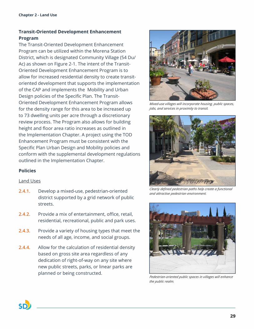
Mixed-use villages will incorporate housing, public spaces, jobs, and services in proximity to transit.
Clearly defined pedestrian paths help create a functional and attractive pedestrian environment.
Pedestrian-oriented public spaces in villages will enhance the public realm.
30
Morena Corridor Specific Plan
Mobility
2.4.5. Connect Morena Boulevard and Sherman Street within the Morena Village District to establish a grid network that enhances multi-modal connectivity.
2.4.6. Complete the roadway extensions through acquisition or dedication of right-of-way. The acquisition of necessary right-of-way from affected property owners could include a transfer of City-owned right-of-way that would be vacated through the process.
2.4.7. Support the vacation and sale of excess right-of-way not needed for circulation as part of development project approvals.
2.4.8. Provide a system of interconnect pedestrian paths that connect to sidewalks to provide enhanced connectivity to the University of San Diego and the Morena Trolley Station.
2.4.9. Provide continuous, clearly marked walkways within development that connect across streets and drives with enhanced paving.
2.4.10. Utilize shared structured parking serving multiple uses to efficiently meet the parking needs of the village.
Public Space/Recreation
2.4.11. Provide a population-based park component to serve the needs of residential uses located within the village which can include mini park, plazas or urban greens for active and passive recreation.
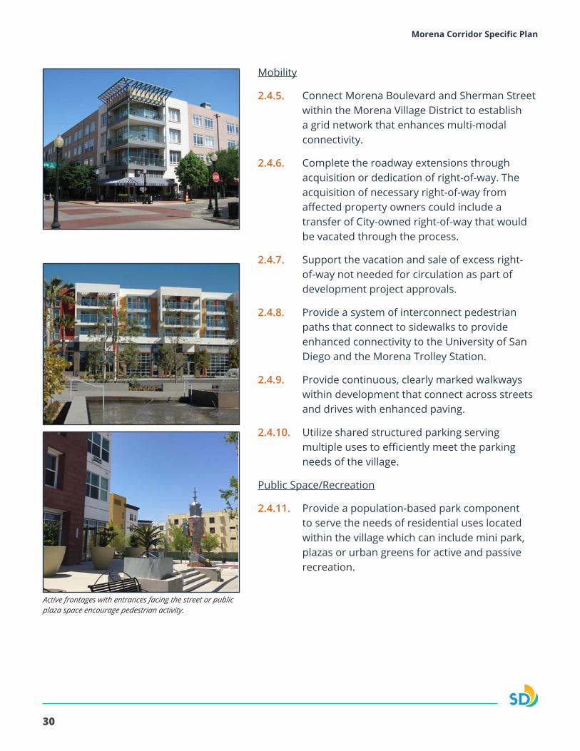
Active frontages with entrances facing the street or public plaza space encourage pedestrian activity.
31
Morena Corridor Specific Plan Chapter 2 - Land Use
Urban Design
2.4.12. Orient building entrances fronting public streets, while allowing for the incorporation of public plazas, public spaces and other pedestrian amenities.
2.4.13. Building heights should transition from lower scale buildings along Cushman Avenue to higher scale buildings toward Linda Vista Road when utilizing the Transit-Oriented Development Enhancement Program
2.4.14. Employ a combination of setbacks, upper-story step-backs, and articulated sub volumes to transition buildings from Cushman Avenue to Linda Vista Road.
2.4.15. Provide pedestrian plazas, where possible to help activate street corners and to complement fronting uses.
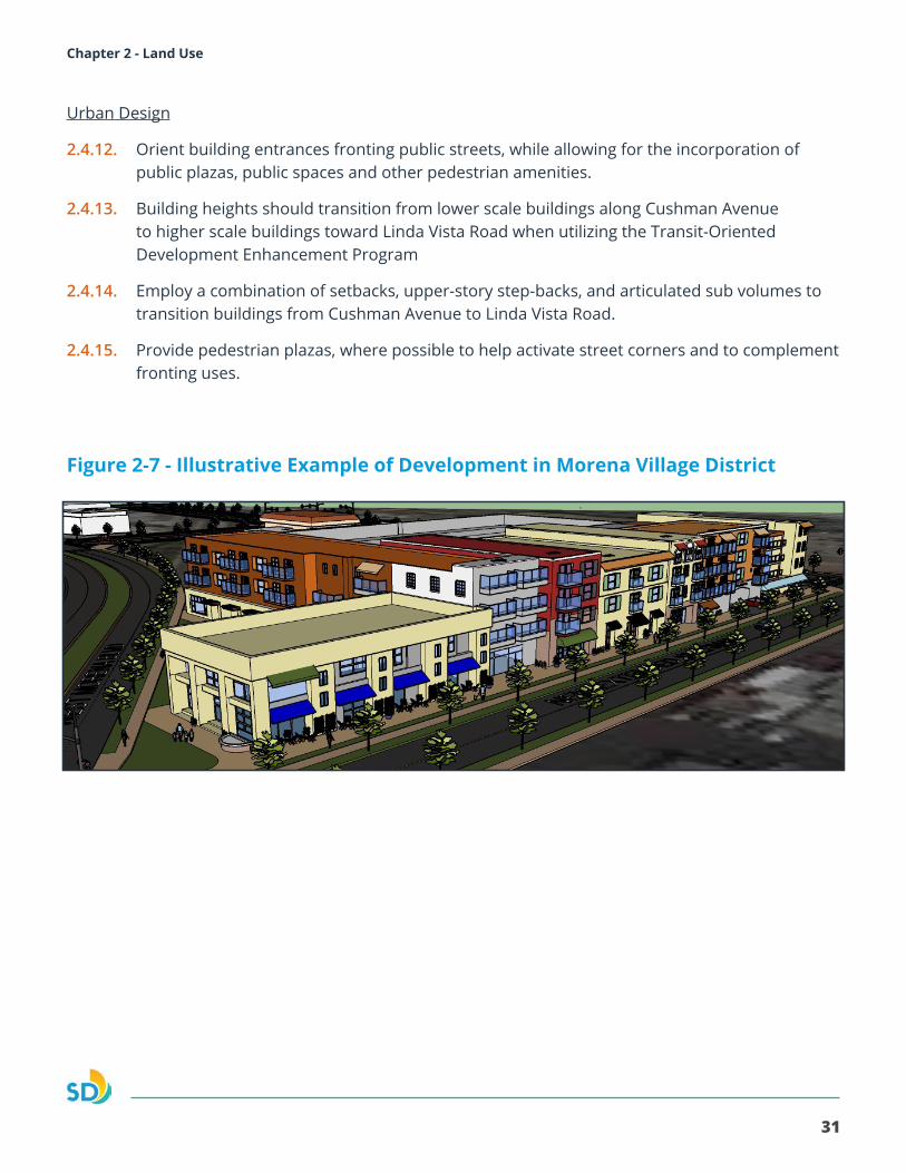
Figure 2-7 - Illustrative Example of Development in Morena Village District
32
Morena Corridor Specific Plan
Figure 2-8 - Employment District
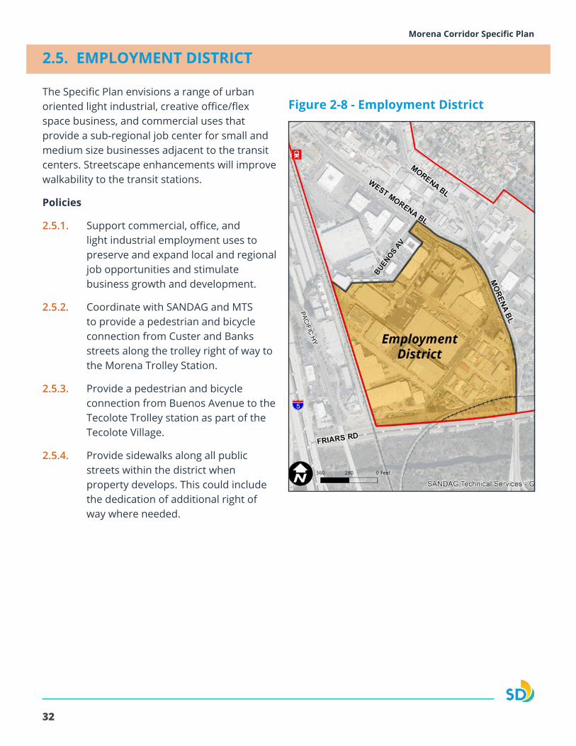
2.5. EMPLOYMENT DISTRICT
The Specific Plan envisions a range of urban oriented light industrial, creative office/flex space business, and commercial uses that provide a sub-regional job center for small and medium size businesses adjacent to the transit centers. Streetscape enhancements will improve walkability to the transit stations.
Policies
2.5.1. Support commercial, office, and light industrial employment uses to preserve and expand local and regional job opportunities and stimulate business growth and development.
2.5.2. Coordinate with SANDAG and MTS to provide a pedestrian and bicycle connection from Custer and Banks streets along the trolley right of way to the Morena Trolley Station.
2.5.3. Provide a pedestrian and bicycle connection from Buenos Avenue to the Tecolote Trolley station as part of the Tecolote Village.
2.5.4. Provide sidewalks along all public streets within the district when property develops. This could include the dedication of additional right of way where needed.
33
Morena Corridor Specific Plan Chapter 2 - Land Use
CLAIREMONT MESA
LINDA VISTA
Fiesta Island
Mission Bay
W. Morena Blvd
Morena Blvd
Morena Blvd
Mor
ena
Blvd
Pacific Highway
Clairemont Dr
Tecolote Rd
Linda Vista Rd
Friars Rd
Tecolote Village District
Planned Transit Station
Specific Plan BoundaryCommunity Planning Area
Existing Transit Station
Employment DistrictArtisian DistrictMorena Station DistrictClairemont District
0 1,500750FeetI
ArtisanDistrict
Figure 2-9 - Artisan District
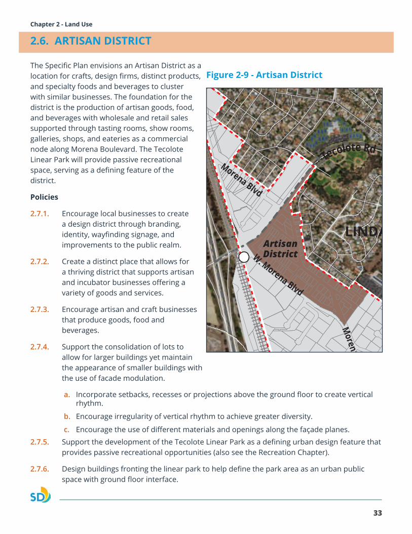
2.6. ARTISAN DISTRICT
The Specific Plan envisions an Artisan District as a location for crafts, design firms, distinct products, and specialty foods and beverages to cluster with similar businesses. The foundation for the district is the production of artisan goods, food, and beverages with wholesale and retail sales supported through tasting rooms, show rooms, galleries, shops, and eateries as a commercial node along Morena Boulevard. The Tecolote Linear Park will provide passive recreational space, serving as a defining feature of the district.
Policies
2.7.1. Encourage local businesses to create a design district through branding, identity, wayfinding signage, and improvements to the public realm.
2.7.2. Create a distinct place that allows for a thriving district that supports artisan and incubator businesses offering a variety of goods and services.
2.7.3. Encourage artisan and craft businesses that produce goods, food and beverages.
2.7.4. Support the consolidation of lots to allow for larger buildings yet maintain the appearance of smaller buildings with the use of facade modulation.
a. Incorporate setbacks, recesses or projections above the ground floor to create vertical rhythm.
b. Encourage irregularity of vertical rhythm to achieve greater diversity.
c. Encourage the use of different materials and openings along the façade planes.
2.7.5. Support the development of the Tecolote Linear Park as a defining urban design feature that provides passive recreational opportunities (also see the Recreation Chapter).
2.7.6. Design buildings fronting the linear park to help define the park area as an urban public space with ground floor interface.
34
Morena Corridor Specific PlanMorena Corridor Specific Plan
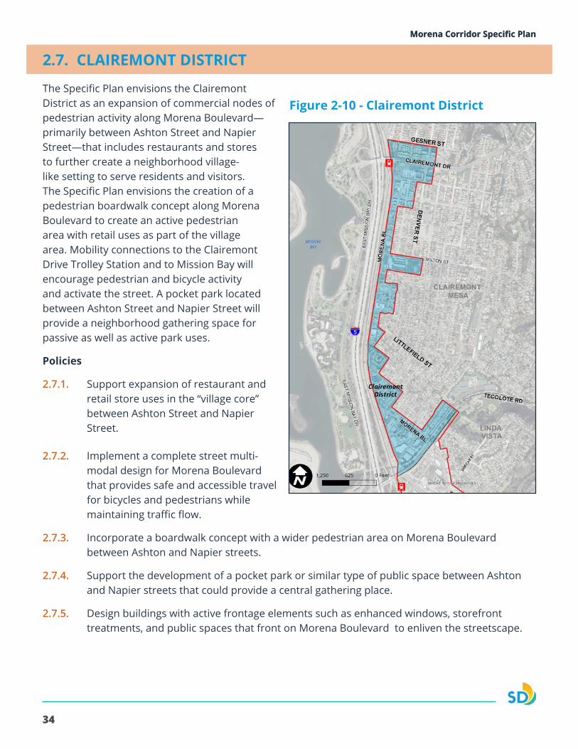
2.7. CLAIREMONT DISTRICT
The Specific Plan envisions the Clairemont District as an expansion of commercial nodes of pedestrian activity along Morena Boulevard—primarily between Ashton Street and Napier Street—that includes restaurants and stores to further create a neighborhood village-like setting to serve residents and visitors. The Specific Plan envisions the creation of a pedestrian boardwalk concept along Morena Boulevard to create an active pedestrian area with retail uses as part of the village area. Mobility connections to the Clairemont Drive Trolley Station and to Mission Bay will encourage pedestrian and bicycle activity and activate the street. A pocket park located between Ashton Street and Napier Street will provide a neighborhood gathering space for passive as well as active park uses.
Policies
2.7.1. Support expansion of restaurant and retail store uses in the “village core” between Ashton Street and Napier Street.
Figure 2-10 - Clairemont District
2.7.2. Implement a complete street multi-modal design for Morena Boulevard that provides safe and accessible travel for bicycles and pedestrians while maintaining traffic flow.
2.7.3. Incorporate a boardwalk concept with a wider pedestrian area on Morena Boulevard between Ashton and Napier streets.
2.7.4. Support the development of a pocket park or similar type of public space between Ashton and Napier streets that could provide a central gathering place.
2.7.5. Design buildings with active frontage elements such as enhanced windows, storefront treatments, and public spaces that front on Morena Boulevard to enliven the streetscape.
35
Morena Corridor Specific Plan Chapter 3 - MobilityMorena Corridor Specific Plan
The Mobility chapter provides recommendations for a complete streets network by providing multi-modal benefits that will improve the safety, comfort and operations of pedestrians, bicyclists, transit riders, and motorists. Significant mobility improvements include the extensions of roadways that establish a modified grid network in the Linda Vista community. The roadway extensions are provided through acquisition or dedication of right-of-way. The acquisition of necessary right-of-way from affected property owners could include a transfer of City-owned right-of-way that would be vacated through the implementation of the planned mobility improvements.
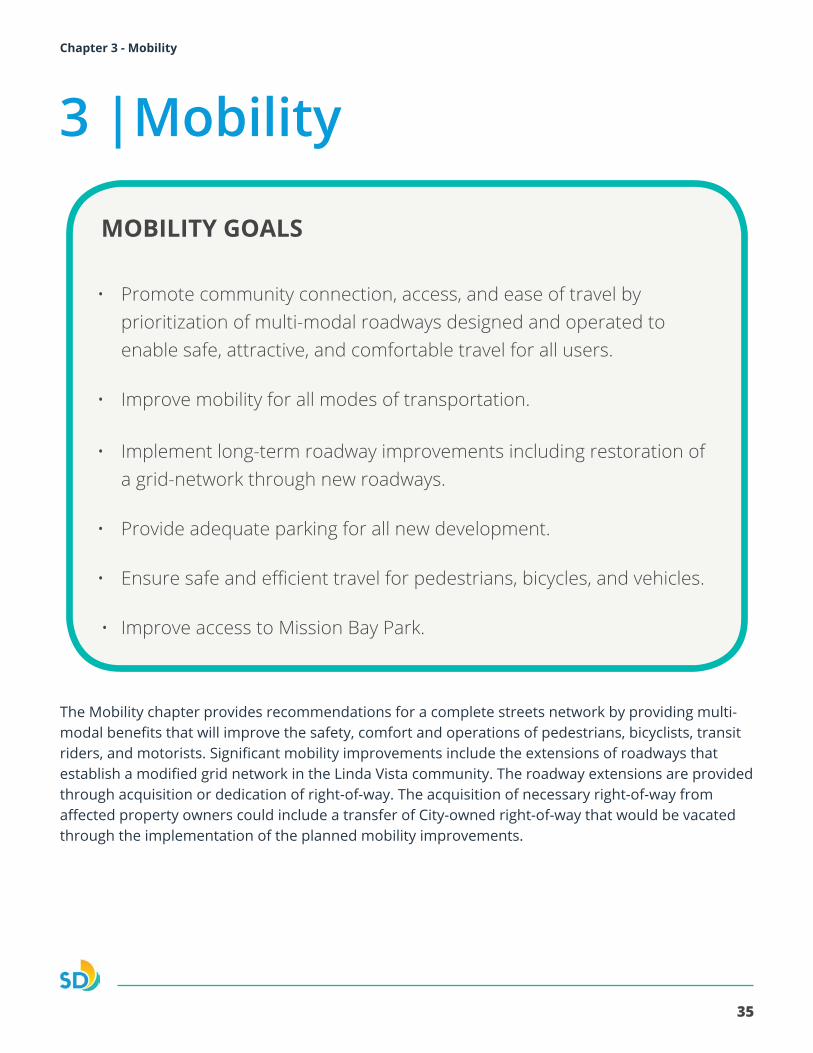
MOBILITY GOALS
• Promote community connection, access, and ease of travel by prioritization of multi-modal roadways designed and operated to enable safe, attractive, and comfortable travel for all users.
• Improve mobility for all modes of transportation.
• Implement long-term roadway improvements including restoration of a grid-network through new roadways.
• Provide adequate parking for all new development.
• Ensure safe and efficient travel for pedestrians, bicycles, and vehicles.
• Improve access to Mission Bay Park.
3 |Mobility
36
Morena Corridor Specific Plan
I2
I2
!
!
!
!
!! !
!!
!!
!!
!
"
"
MISSIONBAY
!"̂$University
of San Diego
SAN DIEGO RIVER
FLOODWAY
!"_$
GARDENA AV
TECOLOTE RD
ILLI
ON
ST
LINDA VISTA RD
ERIE
ST
MORENA BLVD
W. MORENA BLVD
MILTON ST
FRIARS RD
EAST
MIS
SIO
N B
AY D
R
SEA WORLD DR
PACIFIC HY
MISSION BAY PARK
CLAIREMONT MESA
LINDA VISTA
MISSION VALLEY
5
1
6
9
8
7
3
2
10 15
17
16
14
11
12
13
2012 San Diego Imagery Acquisition Partnership (Flight Dates: May 20 -June 6, 2012)
THIS MAP IS PROVIDED WITHOUT WARRANTY OF ANY KIND, EITHER EXPRESS OR IMPLIED, INCLUDING BUT NOT LIMITED TO, THE IMPLIED WARRANTIES OF MERCHANTABILITY AND FITNESS, FOR A PARTICULAR PURPOSE. Copyright SanGIS. All Rights Reserved. This product may contain information from the SANDAG Regional Information System which cannot be reproduced without written permission of SANDAG. This product may contain information which has been reproduced with permission granted by Thomas Bros. Maps.
Roadway Modifications!! !! !! Vacation / Abandoned
Extension / Addition
Specific Plan Boundary
" Proposed Cross-Section
! Proposed Intersection
I2 Existing Station
I2 Proposed Station
Planning Areas
Morena Corridor Specific Plan
600 0 600300
Feet
Date: 6/14/2017Document Path: L:\GIS\PGIS\Smart Growth Grants\MorenaBlvd\MXD\Smart_Growth_Morena_Proposed_Street_Mobility_May2017.mxd
Proposed Mobility Network Improvements
0 1,500750FeetI
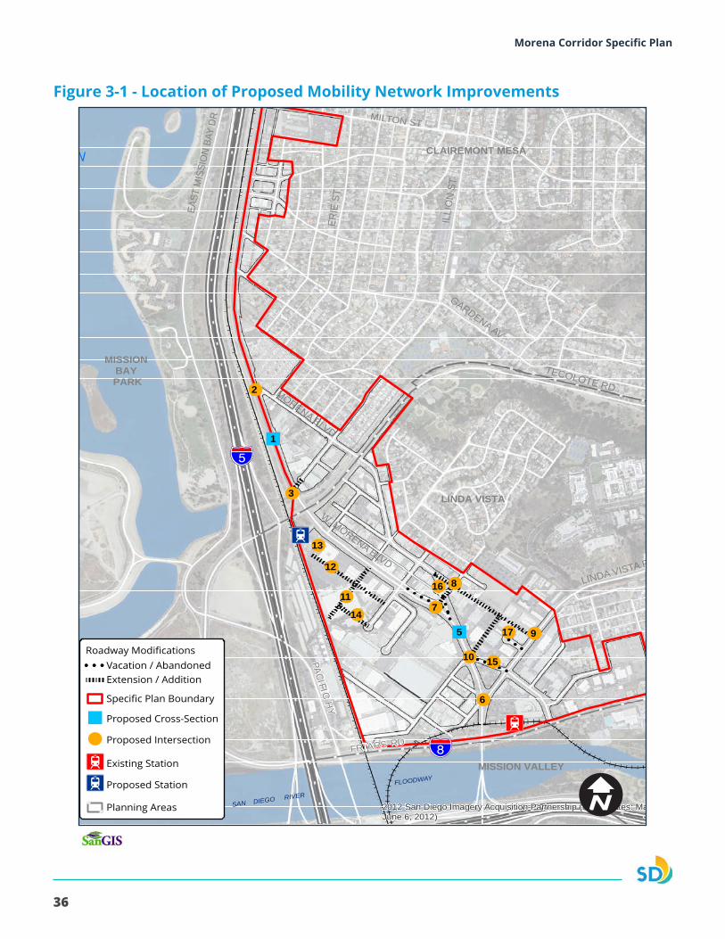
Figure 3-1 - Location of Proposed Mobility Network Improvements
37
Morena Corridor Specific Plan Chapter 3 - Mobility
3.1. MOBILITY IMPROVEMENTS
The mobility improvements benefit all modes by providing direct routes of travel and address safety through increased visibility. Figure 3-1 illustrates the proposed mobility improvements. The new streets, street extensions and intersections should be designed consistent with the City’s Street Design Manual for their respective classifications.
Two-Way Cycle Track Buffer SB Travel Lane NB Travel Lane NB Travel Lane Parking SidewalkCenter Left Turn Lane
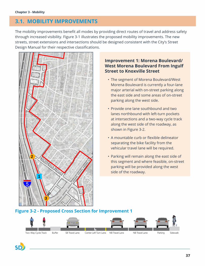
Improvement 1: Morena Boulevard/West Morena Boulevard From Ingulf Street to Knoxville Street
• The segment of Morena Boulevard/West Morena Boulevard is currently a four-lane major arterial with on-street parking along the east side and some areas of on-street parking along the west side.
• Provide one lane southbound and two lanes northbound with left-turn pockets at intersections and a two-way cycle track along the west side of the roadway, as shown in Figure 3-2.
• A mountable curb or flexible delineator separating the bike facility from the vehicular travel lane will be required.
• Parking will remain along the east side of this segment and where feasible, on-street parking will be provided along the west side of the roadway.
Figure 3-2 - Proposed Cross Section for Improvement 1I2
I2
!
!
!
!
!! !
!!
!!
!!
!
"
"
MISSIONBAY
!"̂$University
of San Diego
SAN DIEGO RIVER
FLOODWAY
!"_$
GARDENA AV
TECOLOTE RD
ILLI
ON
ST
LINDA VISTA RD
ERIE
ST
MORENA BLVD
W. MORENA BLVD
MILTON ST
FRIARS RD
EAST
MIS
SIO
N B
AY D
R
SEA WORLD DR
PACIFIC HY
MISSION BAY PARK
CLAIREMONT MESA
LINDA VISTA
MISSION VALLEY
5
1
6
9
8
7
3
2
10 15
17
16
14
11
12
13
2012 San Diego Imagery Acquisition Partnership (Flight Dates: May 20 -June 6, 2012)
THIS MAP IS PROVIDED WITHOUT WARRANTY OF ANY KIND, EITHER EXPRESS OR IMPLIED, INCLUDING BUT NOT LIMITED TO, THE IMPLIED WARRANTIES OF MERCHANTABILITY AND FITNESS, FOR A PARTICULAR PURPOSE. Copyright SanGIS. All Rights Reserved. This product may contain information from the SANDAG Regional Information System which cannot be reproduced without written permission of SANDAG. This product may contain information which has been reproduced with permission granted by Thomas Bros. Maps.
Roadway Modifications!! !! !! Vacation / Abandoned
Extension / Addition
Specific Plan Boundary
" Proposed Cross-Section
! Proposed Intersection
I2 Existing Station
I2 Proposed Station
Planning Areas
Morena Corridor Specific Plan
600 0 600300
Feet
Date: 6/14/2017Document Path: L:\GIS\PGIS\Smart Growth Grants\MorenaBlvd\MXD\Smart_Growth_Morena_Proposed_Street_Mobility_May2017.mxd
Proposed Mobility Network Improvements
38
Morena Corridor Specific Plan
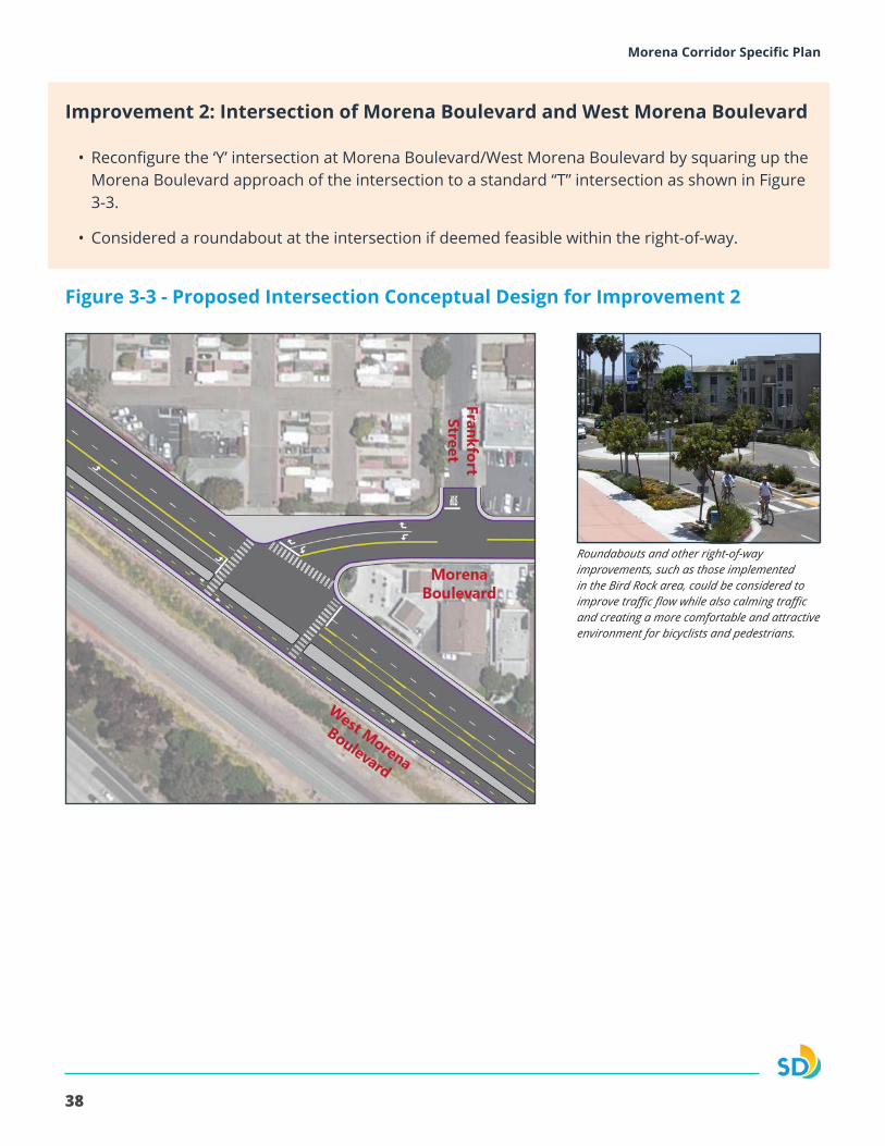
Improvement 2: Intersection of Morena Boulevard and West Morena Boulevard
• Reconfigure the ‘Y’ intersection at Morena Boulevard/West Morena Boulevard by squaring up the Morena Boulevard approach of the intersection to a standard “T” intersection as shown in Figure 3-3.
• Considered a roundabout at the intersection if deemed feasible within the right-of-way.
Figure 3-3 - Proposed Intersection Conceptual Design for Improvement 2
Roundabouts and other right-of-way improvements, such as those implemented in the Bird Rock area, could be considered to improve traffic flow while also calming traffic and creating a more comfortable and attractive environment for bicyclists and pedestrians.
39
Morena Corridor Specific Plan Chapter 3 - Mobility
Improvement 4: West Morena Boulevard from Vega Street to Cushman Street Road Diet
• The segment of West Morena Boulevard is currently a five lane major arterial with on-street parking along the west side and some areas of on-street parking along the east side.
• Remove one southbound lane and maintain two northbound lanes with left-turn pockets and provide a two-way cycle track along the west side of the roadway, as shown in Figure 3-5.
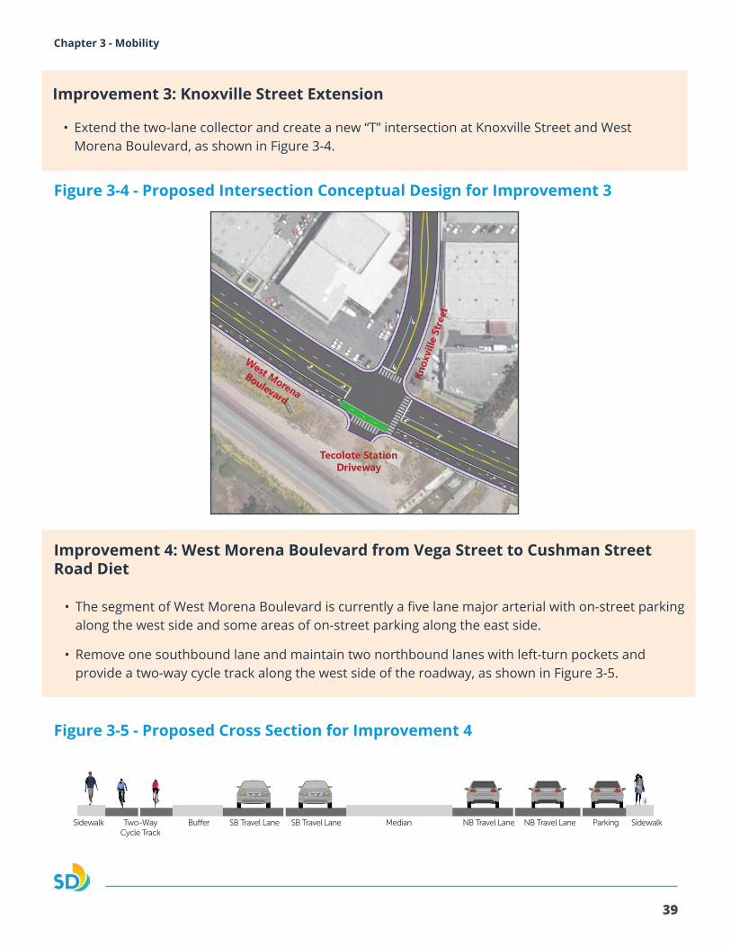
Improvement 3: Knoxville Street Extension
Two-Way Cycle Track
Buffer SB Travel Lane NB Travel Lane Parking SidewalkMedian NB Travel LaneSB Travel LaneSidewalk
• Extend the two-lane collector and create a new “T” intersection at Knoxville Street and West Morena Boulevard, as shown in Figure 3-4.
Figure 3-5 - Proposed Cross Section for Improvement 4
Figure 3-4 - Proposed Intersection Conceptual Design for Improvement 3
40
Morena Corridor Specific Plan
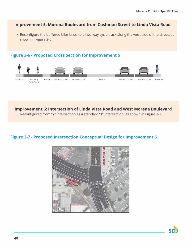
Improvement 5: Morena Boulevard from Cushman Street to Linda Vista Road
• Reconfigure the buffered bike lanes to a two-way cycle track along the west side of the street, as shown in Figure 3-6.
Improvement 6: Intersection of Linda Vista Road and West Morena Boulevard• Reconfigured from “Y” intersection as a standard “T” intersection, as shown in Figure 3-7.
Two-Way Cycle Track
Buffer SB Travel Lane Median NB Travel Lane SidewalkNB Travel LaneSB Travel LaneSidewalk Sidewalk
Figure 3-6 - Proposed Cross Section for Improvement 5
Figure 3-7 - Proposed Intersection Conceptual Design for Improvement 6
41
Morena Corridor Specific Plan Chapter 3 - Mobility
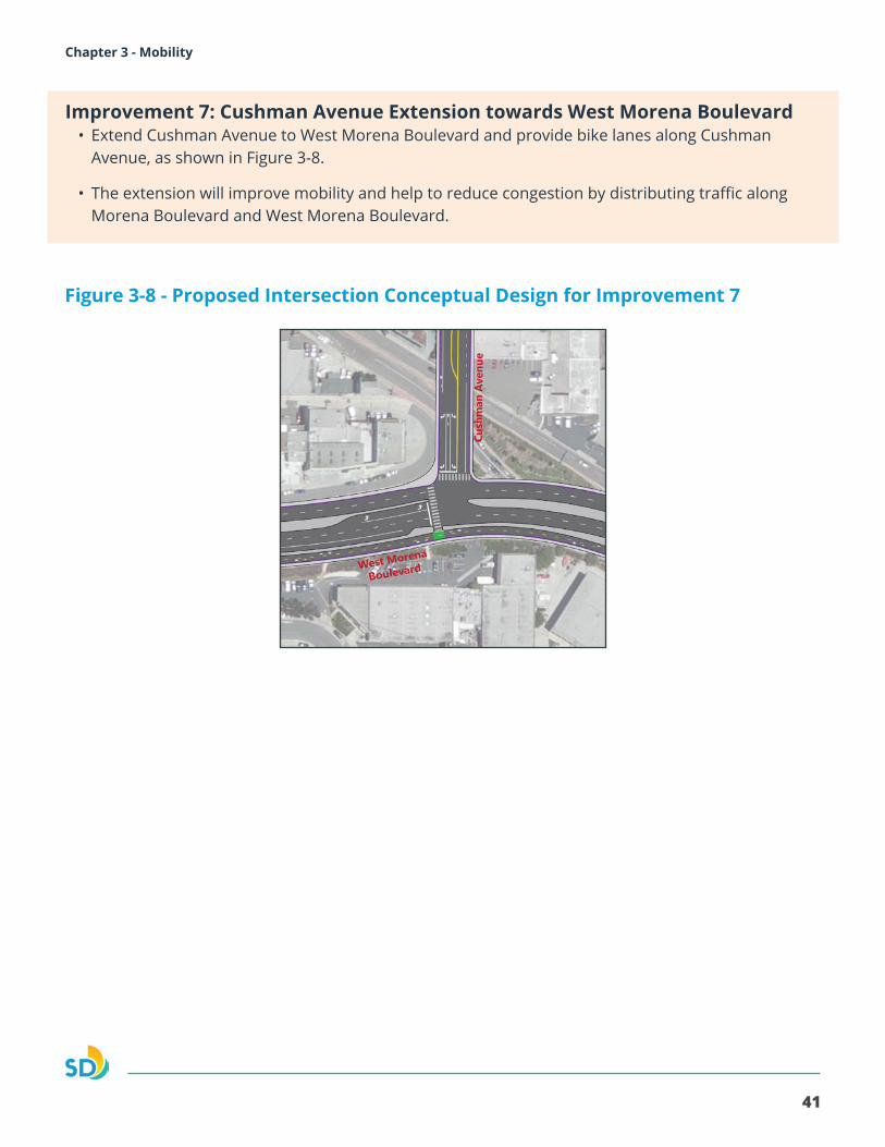
Improvement 7: Cushman Avenue Extension towards West Morena Boulevard• Extend Cushman Avenue to West Morena Boulevard and provide bike lanes along Cushman
Avenue, as shown in Figure 3-8.
• The extension will improve mobility and help to reduce congestion by distributing traffic along Morena Boulevard and West Morena Boulevard.
Figure 3-8 - Proposed Intersection Conceptual Design for Improvement 7
42
Morena Corridor Specific Plan
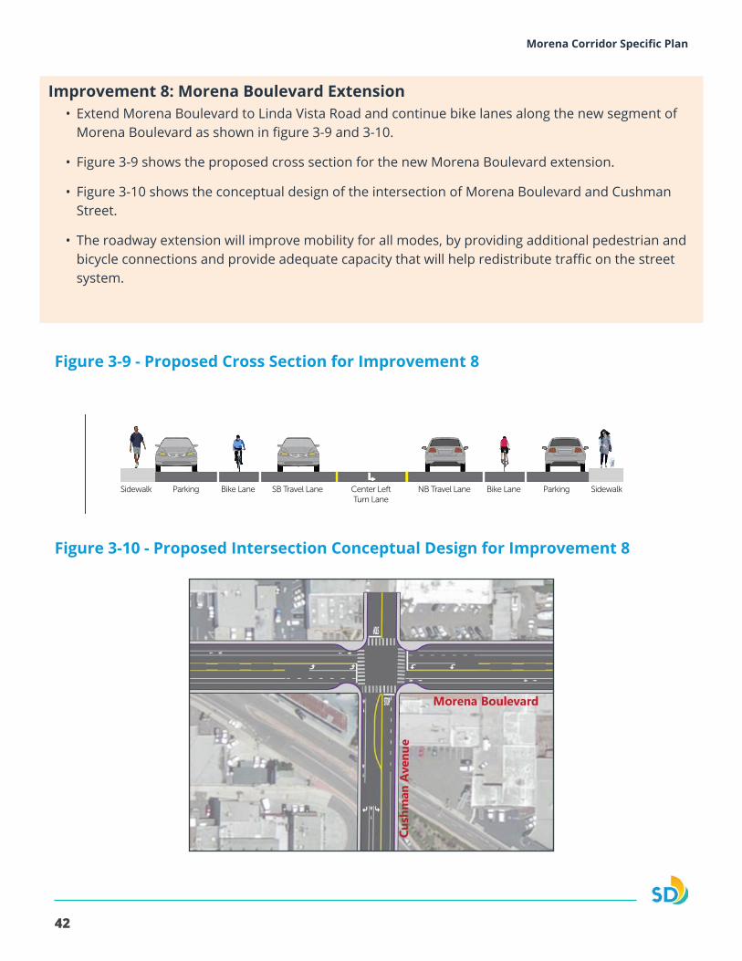
• Extend Morena Boulevard to Linda Vista Road and continue bike lanes along the new segment of Morena Boulevard as shown in figure 3-9 and 3-10.
• Figure 3-9 shows the proposed cross section for the new Morena Boulevard extension.
• Figure 3-10 shows the conceptual design of the intersection of Morena Boulevard and Cushman Street.
• The roadway extension will improve mobility for all modes, by providing additional pedestrian and bicycle connections and provide adequate capacity that will help redistribute traffic on the street system.
SB Travel Lane NB Travel LaneCenter Left Turn Lane
SidewalkParkingBike LaneBike LaneSidewalk Parking
Figure 3-10 - Proposed Intersection Conceptual Design for Improvement 8
Figure 3-9 - Proposed Cross Section for Improvement 8
Improvement 8: Morena Boulevard Extension
43
Morena Corridor Specific Plan Chapter 3 - Mobility
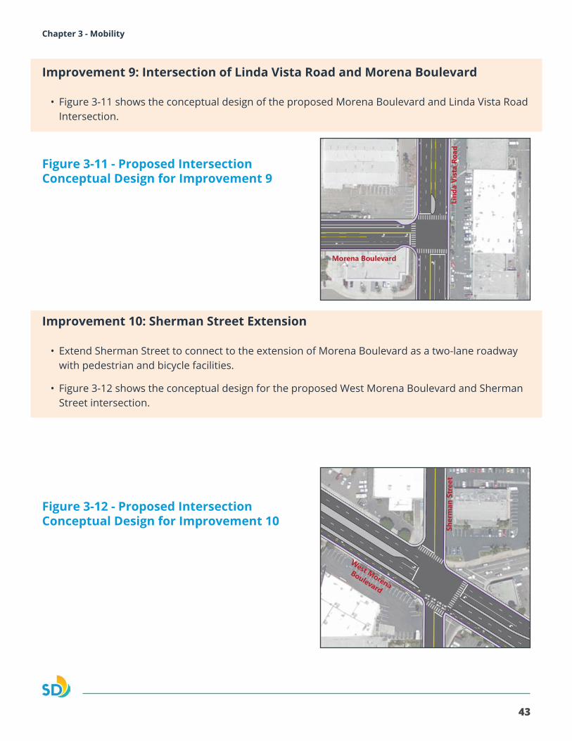
Improvement 9: Intersection of Linda Vista Road and Morena Boulevard
• Figure 3-11 shows the conceptual design of the proposed Morena Boulevard and Linda Vista Road Intersection.
Improvement 10: Sherman Street Extension
• Extend Sherman Street to connect to the extension of Morena Boulevard as a two-lane roadway with pedestrian and bicycle facilities.
• Figure 3-12 shows the conceptual design for the proposed West Morena Boulevard and Sherman Street intersection.
Figure 3-11 - Proposed Intersection Conceptual Design for Improvement 9
Figure 3-12 - Proposed Intersection Conceptual Design for Improvement 10
44
Morena Corridor Specific Plan
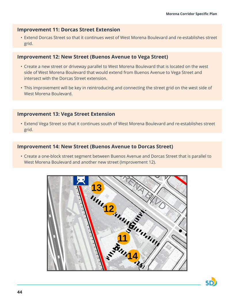
Improvement 11: Dorcas Street Extension• Extend Dorcas Street so that it continues west of West Morena Boulevard and re-establishes street
grid.
Improvement 12: New Street (Buenos Avenue to Vega Street)
• Create a new street or driveway parallel to West Morena Boulevard that is located on the west side of West Morena Boulevard that would extend from Buenos Avenue to Vega Street and intersect with the Dorcas Street extension.
• This improvement will be key in reintroducing and connecting the street grid on the west side of West Morena Boulevard.
Improvement 13: Vega Street Extension
• Extend Vega Street so that it continues south of West Morena Boulevard and re-establishes street grid.
Improvement 14: New Street (Buenos Avenue to Dorcas Street)
• Create a one-block street segment between Buenos Avenue and Dorcas Street that is parallel to West Morena Boulevard and another new street (Improvement 12).
I2
I2
!
!
!
!
!! !
!!
!!
!!
!
"
"
MISSIONBAY
!"̂$University
of San Diego
SAN DIEGO RIVER
FLOODWAY
!"_$
GARDENA AV
TECOLOTE RD
ILLI
ON
ST
LINDA VISTA RD
ERIE
ST
MORENA BLVD
W. MORENA BLVD
MILTON ST
FRIARS RD
EAST
MIS
SIO
N B
AY D
R
SEA WORLD DR
PACIFIC HY
MISSION BAY PARK
CLAIREMONT MESA
LINDA VISTA
MISSION VALLEY
5
1
6
9
8
7
3
2
10 15
17
16
14
11
12
13
2012 San Diego Imagery Acquisition Partnership (Flight Dates: May 20 -June 6, 2012)
THIS MAP IS PROVIDED WITHOUT WARRANTY OF ANY KIND, EITHER EXPRESS OR IMPLIED, INCLUDING BUT NOT LIMITED TO, THE IMPLIED WARRANTIES OF MERCHANTABILITY AND FITNESS, FOR A PARTICULAR PURPOSE. Copyright SanGIS. All Rights Reserved. This product may contain information from the SANDAG Regional Information System which cannot be reproduced without written permission of SANDAG. This product may contain information which has been reproduced with permission granted by Thomas Bros. Maps.
Roadway Modifications!! !! !! Vacation / Abandoned
Extension / Addition
Specific Plan Boundary
" Proposed Cross-Section
! Proposed Intersection
I2 Existing Station
I2 Proposed Station
Planning Areas
Morena Corridor Specific Plan
600 0 600300
Feet
Date: 6/14/2017Document Path: L:\GIS\PGIS\Smart Growth Grants\MorenaBlvd\MXD\Smart_Growth_Morena_Proposed_Street_Mobility_May2017.mxd
Proposed Mobility Network Improvements
45
Morena Corridor Specific Plan Chapter 3 - Mobility
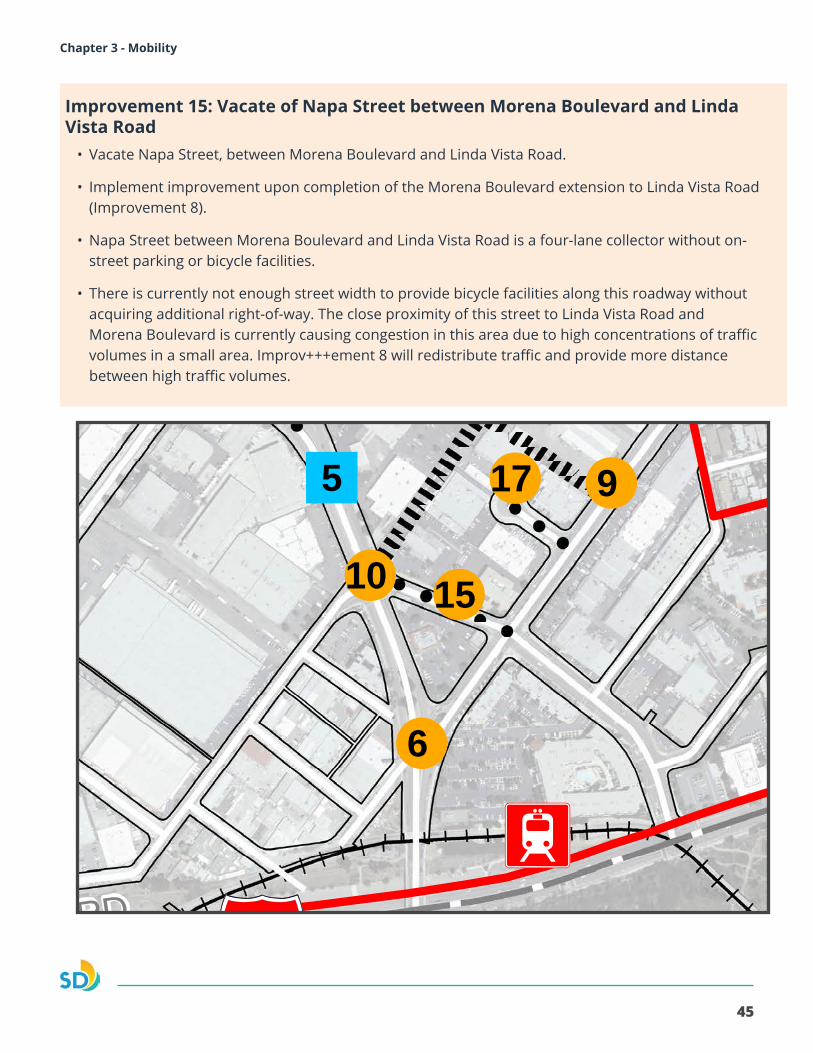
Improvement 15: Vacate of Napa Street between Morena Boulevard and Linda Vista Road
• Vacate Napa Street, between Morena Boulevard and Linda Vista Road.
• Implement improvement upon completion of the Morena Boulevard extension to Linda Vista Road (Improvement 8).
• Napa Street between Morena Boulevard and Linda Vista Road is a four-lane collector without on-street parking or bicycle facilities.
• There is currently not enough street width to provide bicycle facilities along this roadway without acquiring additional right-of-way. The close proximity of this street to Linda Vista Road and Morena Boulevard is currently causing congestion in this area due to high concentrations of traffic volumes in a small area. Improv+++ement 8 will redistribute traffic and provide more distance between high traffic volumes.
I2
I2
!
!
!
!
!! !
!!
!!
!!
!
"
"
MISSIONBAY
!"̂$University
of San Diego
SAN DIEGO RIVER
FLOODWAY
!"_$
GARDENA AV
TECOLOTE RD
ILLI
ON
ST
LINDA VISTA RD
ERIE
ST
MORENA BLVD
W. MORENA BLVD
MILTON ST
FRIARS RD
EAST
MIS
SIO
N B
AY D
R
SEA WORLD DRPACIFIC H
Y
MISSION BAY PARK
CLAIREMONT MESA
LINDA VISTA
MISSION VALLEY
5
1
6
9
8
7
3
2
10 15
17
16
14
11
12
13
2012 San Diego Imagery Acquisition Partnership (Flight Dates: May 20 -June 6, 2012)
THIS MAP IS PROVIDED WITHOUT WARRANTY OF ANY KIND, EITHER EXPRESS OR IMPLIED, INCLUDING BUT NOT LIMITED TO, THE IMPLIED WARRANTIES OF MERCHANTABILITY AND FITNESS, FOR A PARTICULAR PURPOSE. Copyright SanGIS. All Rights Reserved. This product may contain information from the SANDAG Regional Information System which cannot be reproduced without written permission of SANDAG. This product may contain information which has been reproduced with permission granted by Thomas Bros. Maps.
Roadway Modifications!! !! !! Vacation / Abandoned
Extension / Addition
Specific Plan Boundary
" Proposed Cross-Section
! Proposed Intersection
I2 Existing Station
I2 Proposed Station
Planning Areas
Morena Corridor Specific Plan
600 0 600300
Feet
Date: 6/14/2017Document Path: L:\GIS\PGIS\Smart Growth Grants\MorenaBlvd\MXD\Smart_Growth_Morena_Proposed_Street_Mobility_May2017.mxd
Proposed Mobility Network Improvements
46
Morena Corridor Specific Plan
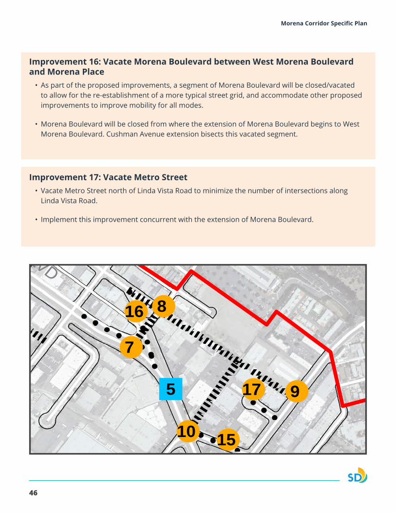
Improvement 16: Vacate Morena Boulevard between West Morena Boulevard and Morena Place
• As part of the proposed improvements, a segment of Morena Boulevard will be closed/vacated to allow for the re-establishment of a more typical street grid, and accommodate other proposed improvements to improve mobility for all modes.
• Morena Boulevard will be closed from where the extension of Morena Boulevard begins to West Morena Boulevard. Cushman Avenue extension bisects this vacated segment.
Improvement 17: Vacate Metro Street• Vacate Metro Street north of Linda Vista Road to minimize the number of intersections along
Linda Vista Road.
• Implement this improvement concurrent with the extension of Morena Boulevard.
I2
I2
!
!
!
!
!! !
!!
!!
!!
!
"
"
MISSIONBAY
!"̂$University
of San Diego
SAN DIEGO RIVER
FLOODWAY
!"_$
GARDENA AV
TECOLOTE RD
ILLI
ON
ST
LINDA VISTA RD
ERIE
ST
MORENA BLVD
W. MORENA BLVD
MILTON ST
FRIARS RD
EAST
MIS
SIO
N B
AY D
R
SEA WORLD DR
PACIFIC HY
MISSION BAY PARK
CLAIREMONT MESA
LINDA VISTA
MISSION VALLEY
5
1
6
9
8
7
3
2
10 15
17
16
14
11
12
13
2012 San Diego Imagery Acquisition Partnership (Flight Dates: May 20 -June 6, 2012)
THIS MAP IS PROVIDED WITHOUT WARRANTY OF ANY KIND, EITHER EXPRESS OR IMPLIED, INCLUDING BUT NOT LIMITED TO, THE IMPLIED WARRANTIES OF MERCHANTABILITY AND FITNESS, FOR A PARTICULAR PURPOSE. Copyright SanGIS. All Rights Reserved. This product may contain information from the SANDAG Regional Information System which cannot be reproduced without written permission of SANDAG. This product may contain information which has been reproduced with permission granted by Thomas Bros. Maps.
Roadway Modifications!! !! !! Vacation / Abandoned
Extension / Addition
Specific Plan Boundary
" Proposed Cross-Section
! Proposed Intersection
I2 Existing Station
I2 Proposed Station
Planning Areas
Morena Corridor Specific Plan
600 0 600300
Feet
Date: 6/14/2017Document Path: L:\GIS\PGIS\Smart Growth Grants\MorenaBlvd\MXD\Smart_Growth_Morena_Proposed_Street_Mobility_May2017.mxd
Proposed Mobility Network Improvements
47
Morena Corridor Specific Plan Chapter 3 - Mobility
3.2. WALKABILITY
The recommended mobility network reconfiguration will re-establish a street grid network, benefiting pedestrian mobility. Street grids provide direct routes as well as alternative parallel routes that maximize connections.
Policies
3.2.1. Consider pedestrian count down timers at signalized intersections, and lighting as part of the design of future streets.
3.2.2. Incorporate high visibility “continenta”l crosswalks at signalized intersections.
3.2.3. Consider the use of curb bulb-outs to minimize the pedestrian crossing distance, where feasible.
3.2.4. Provide non-contiguous sidewalks where possible, with an emphasis on the roadways of Morena Boulevard and West Morena Boulevard.
3.2.5. Coordinate with SANDAG and MTS to improve pedestrian access to the transit stops/stations.
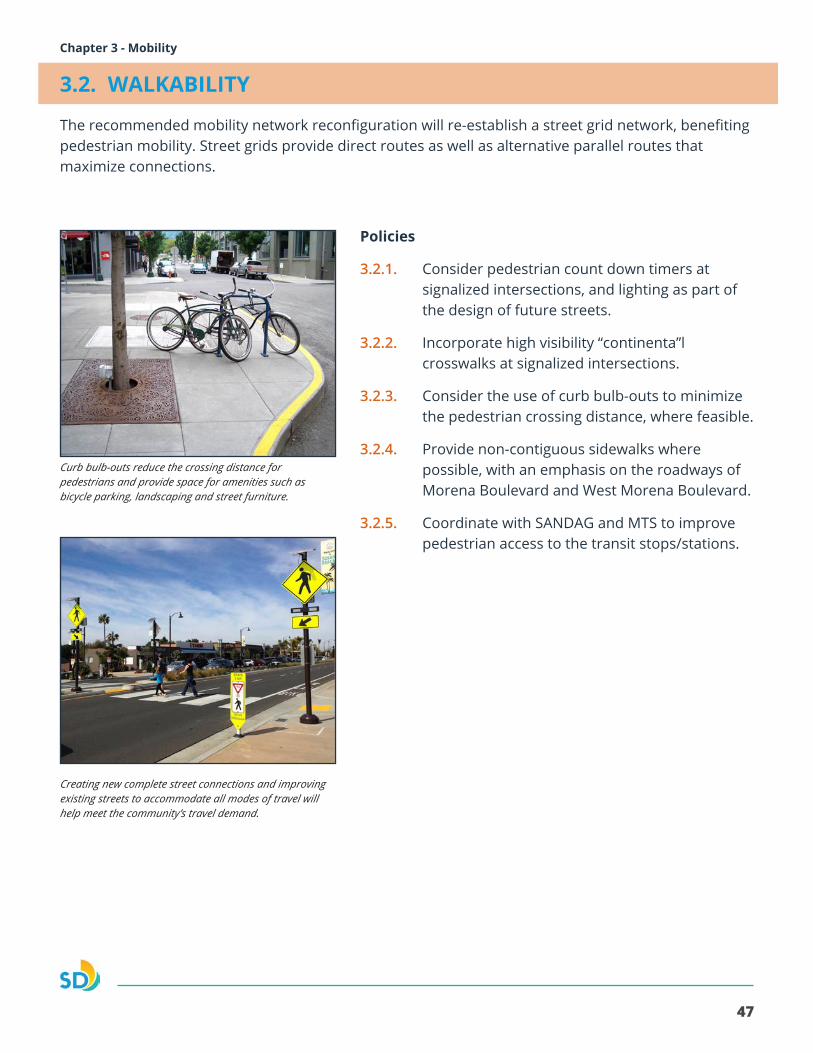
Curb bulb-outs reduce the crossing distance for pedestrians and provide space for amenities such as bicycle parking, landscaping and street furniture.
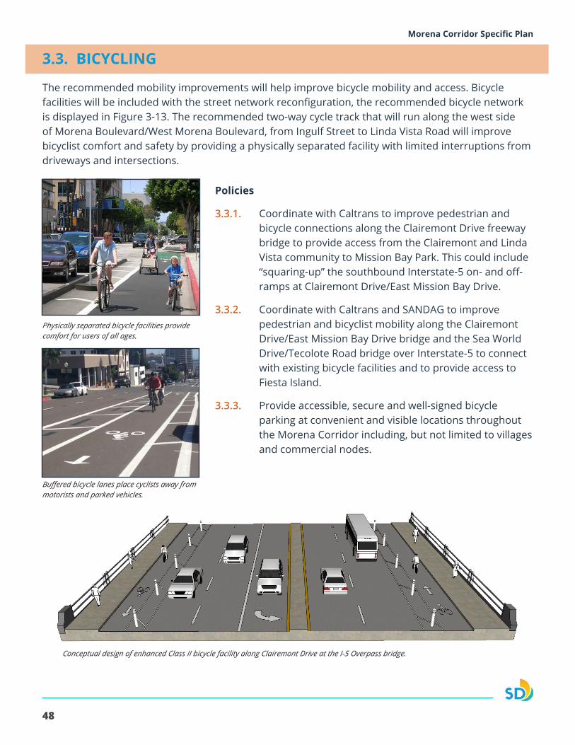
Creating new complete street connections and improving existing streets to accommodate all modes of travel will help meet the community’s travel demand.
48
Morena Corridor Specific Plan
3.3. BICYCLING
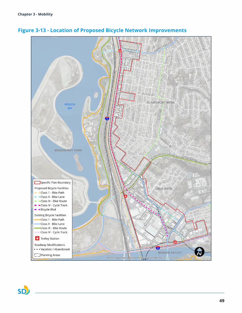
The recommended mobility improvements will help improve bicycle mobility and access. Bicycle facilities will be included with the street network reconfiguration, the recommended bicycle network is displayed in Figure 3-13. The recommended two-way cycle track that will run along the west side of Morena Boulevard/West Morena Boulevard, from Ingulf Street to Linda Vista Road will improve bicyclist comfort and safety by providing a physically separated facility with limited interruptions from driveways and intersections.
Policies
3.3.1. Coordinate with Caltrans to improve pedestrian and bicycle connections along the Clairemont Drive freeway bridge to provide access from the Clairemont and Linda Vista community to Mission Bay Park. This could include “squaring-up” the southbound Interstate-5 on- and off-ramps at Clairemont Drive/East Mission Bay Drive.
3.3.2. Coordinate with Caltrans and SANDAG to improve pedestrian and bicyclist mobility along the Clairemont Drive/East Mission Bay Drive bridge and the Sea World Drive/Tecolote Road bridge over Interstate-5 to connect with existing bicycle facilities and to provide access to Fiesta Island.
3.3.3. Provide accessible, secure and well-signed bicycle parking at convenient and visible locations throughout the Morena Corridor including, but not limited to villages and commercial nodes.
Conceptual design of enhanced Class II bicycle facility along Clairemont Drive at the I-5 Overpass bridge.
Physically separated bicycle facilities provide comfort for users of all ages.
Buffered bicycle lanes place cyclists away from motorists and parked vehicles.
49
Morena Corridor Specific Plan Chapter 3 - Mobility
Figure 3-13 - Location of Proposed Bicycle Network Improvements
50
Morena Corridor Specific Plan
3.4. TRANSIT SERVICE
Public transit in the Specific Plan area includes trolley and bus routes operated by the San Diego Metropolitan Transit System (MTS). The San Diego Trolley Green line provides service to Linda Vista/Morena Transit Station and operates between Santee and Downtown San Diego. The Blue Line provides service to the Tecolote and Clairemont Transit Stations and operates between the Downtown and University communities.
Policies
3.4.1. Coordinate with MTS and SANDAG to provide bus stop waiting areas with shelters and next time bus information as improvements are implemented.
3.4.2. Coordinate with MTS and SANDAG to provide a shuttle servicing key destination areas such as Mission Bay Park, Fiesta Island, and Sea World.
3.4.3. Encourage the continuation of the shuttle from USD to the Old Town Transit Center.
3.4.4. Facilitate coordination between USD and MTS to provide a shuttle service to the Tecolote Station.
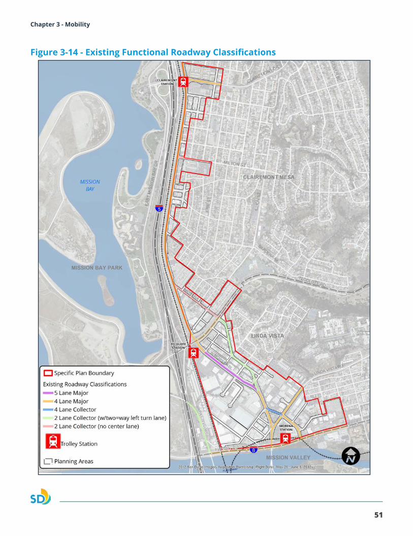
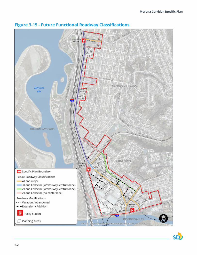
3.5. VEHICULAR MOBILITY
The street network reconfiguration will optimize the efficiency of vehicular movement throughout the Specific Plan area by increasing capacity and reduce congestion. The reconfiguration will increase connectivity, which allows for shorter travel distances. Figure 3-14 displays the existing functional roadway classifications and Figure 3-15 displays the buildout street network and classifications.Policies
3.5.1. Provide an interconnected grid street network between communities to enhance mobility for all modes while providing adequate capacity and reducing congestion on the street system.
3.5.2. Consider using adaptive traffic signals along Morena Boulevard.
3.5.3. Encourage infrastructure for electric vehicles, including vehicle charging stations for multi-family residential, commercial, and industrial uses based on future demand and changes in technology.
3.5.4. Encourage the evaluation of infrastructure for autonomous vehicles when designing right-of-way infrastructure projects and operational improvements based on future demand and changes in technology.
51
Morena Corridor Specific Plan Chapter 3 - Mobility
Figure 3-14 - Existing Functional Roadway Classifications
52
Morena Corridor Specific Plan
Figure 3-15 - Future Functional Roadway Classifications
53
Morena Corridor Specific Plan Chapter 3 - Mobility
4.1. URBAN DESIGN FRAMEWORK
Urban Design addresses the features and relationships of buildings, private and public spaces, and landscapes within the Morena Corridor. The relationship between public and private spaces, including roadway design, building design and architectural character, as well as outdoor spaces and landscaping all contribute to a “sense of place” that will be distinctive and attractive.
The Specific Plan urban design policies guide the relationship between buildings and public spaces, including where access will occur, and how structures and spaces are located in relation to each other. The urban design policies work in conjunction with the land use policies. The urban design policies serve to foster innovative design and site features that complement the public realm and provide connectivity between uses. They are general and illustrative to provide flexibility and encourage creativity and variety through site specific implementation. As the area experiences infill development and building renovations, the Specific Plan encourages development to include innovative and dynamic forms.
URBAN DESIGN GOALS
• A built environment that enhances quality of life and community character.
• New buildings that protect and enhance the Morena Corridor’s distinctive identity.
• Gateways that establish the Morena Corridor as a destination
• A pedestrian oriented public realm with high aesthetic quality, functionality and sustainability.
4 |Urban Design
54
Morena Corridor Specific Plan
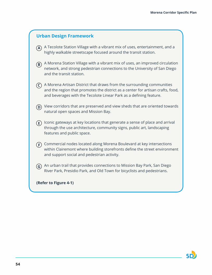
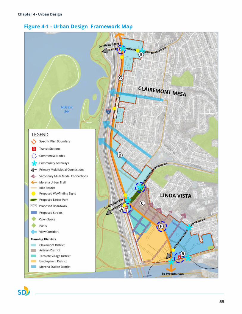
Urban Design Framework
A Tecolote Station Village with a vibrant mix of uses, entertainment, and a highly walkable streetscape focused around the transit station.
A Morena Station Village with a vibrant mix of uses, an improved circulation network, and strong pedestrian connections to the University of San Diego and the transit station.
A Morena Artisan District that draws from the surrounding communities and the region that promotes the district as a center for artisan crafts, food, and beverages with the Tecolote Linear Park as a defining feature.
View corridors that are preserved and view sheds that are oriented towards natural open spaces and Mission Bay.
Iconic gateways at key locations that generate a sense of place and arrival through the use architecture, community signs, public art, landscaping features and public space.
Commercial nodes located along Morena Boulevard at key intersections within Clairemont where building storefronts define the street environment and support social and pedestrian activity.
An urban trail that provides connections to Mission Bay Park, San Diego River Park, Presidio Park, and Old Town for bicyclists and pedestrians.
A
B
C
D
E
F
G
(Refer to Figure 4-1)
55
Morena Corridor Specific Plan Chapter 4 - Urban Design
Figure 4-1 - Urban Design Framework Map
56
Morena Corridor Specific Plan
4.2. STREETSCAPE AND PUBLIC REALM
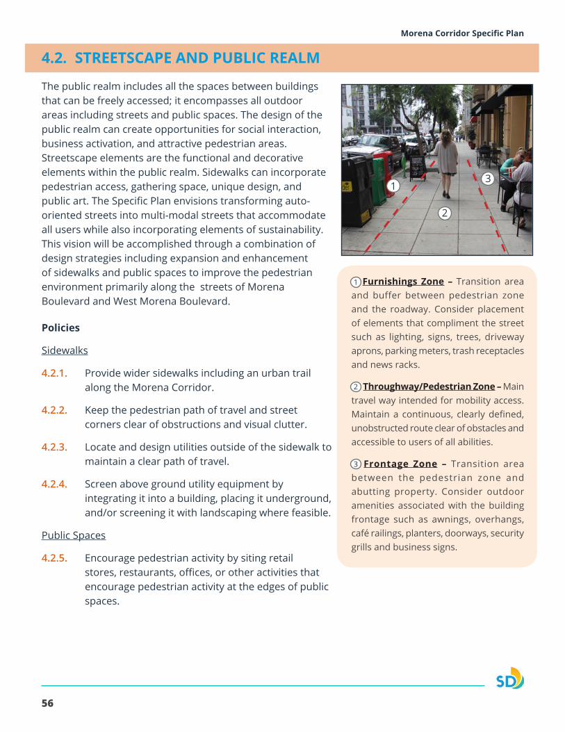
The public realm includes all the spaces between buildings that can be freely accessed; it encompasses all outdoor areas including streets and public spaces. The design of the public realm can create opportunities for social interaction, business activation, and attractive pedestrian areas. Streetscape elements are the functional and decorative elements within the public realm. Sidewalks can incorporate pedestrian access, gathering space, unique design, and public art. The Specific Plan envisions transforming auto-oriented streets into multi-modal streets that accommodate all users while also incorporating elements of sustainability. This vision will be accomplished through a combination of design strategies including expansion and enhancement of sidewalks and public spaces to improve the pedestrian environment primarily along the streets of Morena Boulevard and West Morena Boulevard.
Furnishings Zone – Transition area and buffer between pedestrian zone and the roadway. Consider placement of elements that compliment the street such as lighting, signs, trees, driveway aprons, parking meters, trash receptacles and news racks.
Throughway/Pedestrian Zone – Main travel way intended for mobility access. Maintain a continuous, clearly defined, unobstructed route clear of obstacles and accessible to users of all abilities.
Frontage Zone – Transition area between the pedestrian zone and abutting property. Consider outdoor amenities associated with the building frontage such as awnings, overhangs, café railings, planters, doorways, security grills and business signs.
Policies
Sidewalks
4.2.1. Provide wider sidewalks including an urban trail along the Morena Corridor.
4.2.2. Keep the pedestrian path of travel and street corners clear of obstructions and visual clutter.
4.2.3. Locate and design utilities outside of the sidewalk to maintain a clear path of travel.
4.2.4. Screen above ground utility equipment by integrating it into a building, placing it underground, and/or screening it with landscaping where feasible.
Public Spaces
4.2.5. Encourage pedestrian activity by siting retail stores, restaurants, offices, or other activities that encourage pedestrian activity at the edges of public spaces.
1
1
2
3
2
3
57
Morena Corridor Specific Plan Chapter 4 - Urban Design
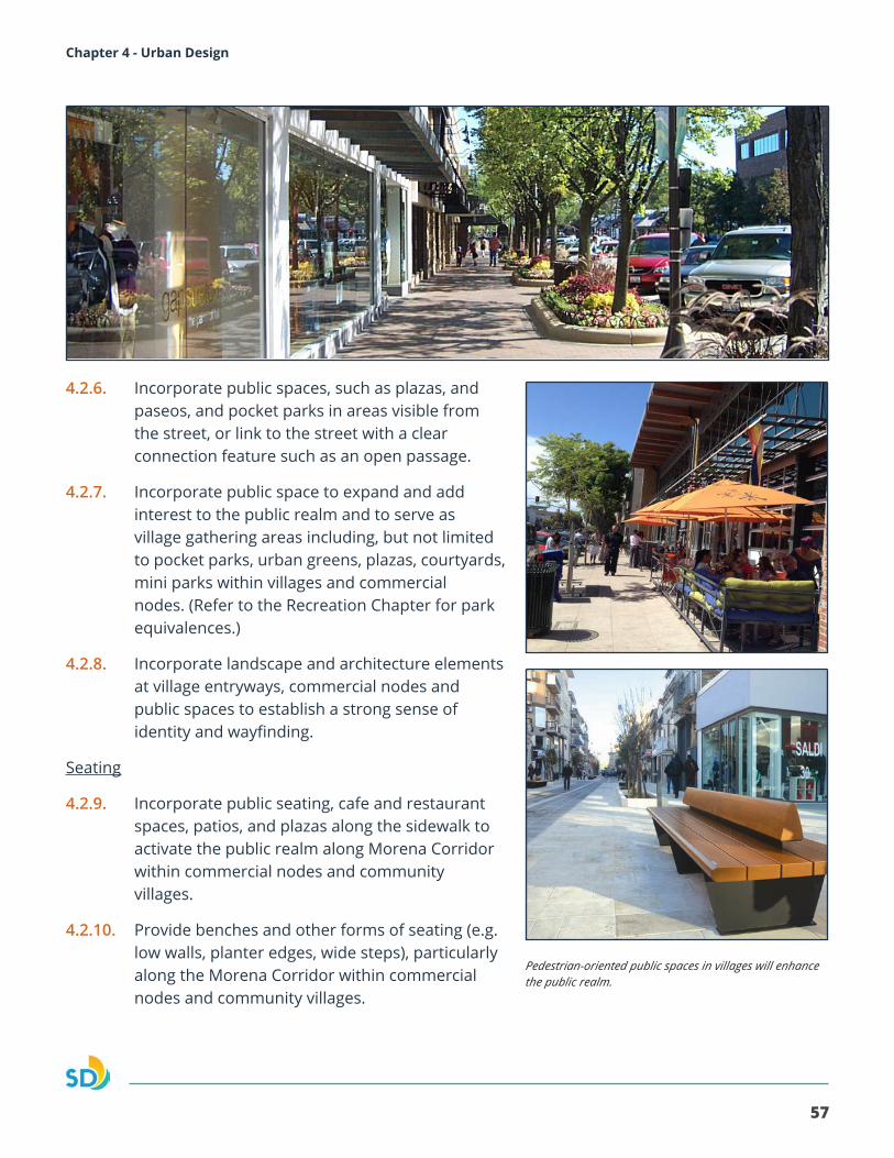
4.2.6. Incorporate public spaces, such as plazas, and paseos, and pocket parks in areas visible from the street, or link to the street with a clear connection feature such as an open passage.
4.2.7. Incorporate public space to expand and add interest to the public realm and to serve as village gathering areas including, but not limited to pocket parks, urban greens, plazas, courtyards, mini parks within villages and commercial nodes. (Refer to the Recreation Chapter for park equivalences.)
4.2.8. Incorporate landscape and architecture elements at village entryways, commercial nodes and public spaces to establish a strong sense of identity and wayfinding.
Seating
4.2.9. Incorporate public seating, cafe and restaurant spaces, patios, and plazas along the sidewalk to activate the public realm along Morena Corridor within commercial nodes and community villages.
4.2.10. Provide benches and other forms of seating (e.g. low walls, planter edges, wide steps), particularly along the Morena Corridor within commercial nodes and community villages.
Pedestrian-oriented public spaces in villages will enhance the public realm.
58
Morena Corridor Specific Plan
Paving
4.2.11. Incorporate enhanced paving design into parking lot design, driveway entries, pedestrian walkways, and plazas, where feasible.
Stormwater
4.2.12. Use permeable ground surfaces in public spaces to the extent possible and install materials that allow access in all weather conditions.
4.2.13. Incorporate permeable paving to reduce storm water runoff and absorption of rainwater.
4.2.14. Incorporate bio-filtration and bio-retention measures in parking lot design, edges of paved areas, and other landscaped areas to capture storm water runoff.
4.2.15. Create green streets that provide “urban greening” features that enhance the pedestrian and bicycle environment, storm water management features, and opportunities for additional street trees.
Lighting
4.2.16. Design the lighting of outdoor areas, such as streets, walkways, parking lots, and public spaces to improve the nighttime environment for safe and enjoyable use.
4.2.17. Utilize outdoor lighting that conserves energy and resources, while providing for safety.
4.2.18. Design outdoor lighting to shield residential areas from adverse effects of night lighting.
4.2.19. Consider the placement, intensity, timing, duration, and color of outdoor lighting.
Enhanced paving, landscaping, and lighting help contribute to a comfortable and attractive pedestrian environment.
59
Morena Corridor Specific Plan Chapter 4 - Urban Design
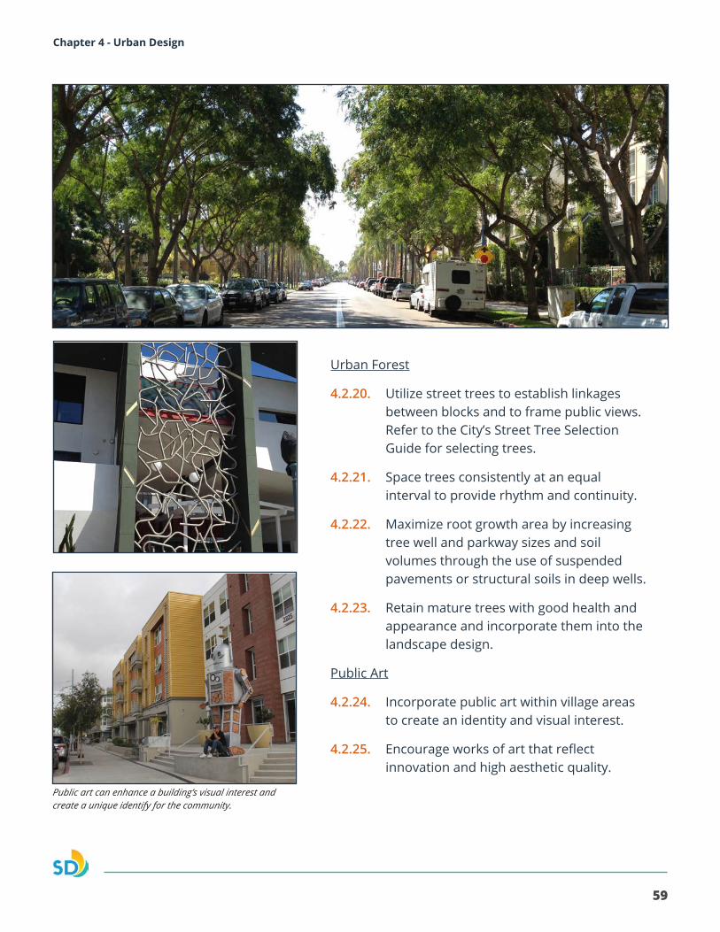
Urban Forest
4.2.20. Utilize street trees to establish linkages between blocks and to frame public views. Refer to the City’s Street Tree Selection Guide for selecting trees.
4.2.21. Space trees consistently at an equal interval to provide rhythm and continuity.
4.2.22. Maximize root growth area by increasing tree well and parkway sizes and soil volumes through the use of suspended pavements or structural soils in deep wells.
4.2.23. Retain mature trees with good health and appearance and incorporate them into the landscape design.
Public Art
4.2.24. Incorporate public art within village areas to create an identity and visual interest.
4.2.25. Encourage works of art that reflect innovation and high aesthetic quality.
Public art can enhance a building’s visual interest and create a unique identify for the community.

60
Morena Corridor Specific Plan
Policies
Branding
4.3.1. Support development of a unique sign and banner branding program for the Morena Corridor to create an attractive and identifiable area which could include gateway signage, directional signage, and district-specific banners displaying events and characteristic uses.
4.3.2. Incorporate the Morena Corridor or district logo and a greeting that is unique to the Morena Corridor on gateway signage.
4.3.3. Support the installation of directional wayfinding signage to define pedestrian, bicycle, and vehicular linkages at gateways nodes and along the Morena Corridor linear gateway.
Linear Gateways
4.3.4. Incorporate linear gateways into existing and future right-of-way to emphasize pedestrian and bicycle mobility where feasible.
Gateway Nodes
4.3.5. Incorporate gateway nodes and pedestrian-oriented retail uses at major entrances to the community that enhance the sense of arrival and establish community character for pedestrians, bicyclists, and vehicles.
4.3. BRANDING AND GATEWAYS
Gateways will help creat a sense of arrival and sense of place that indicates entry to a unique location by providing a visual experience for pedestrians, bicyclists, and motorists. Signage, monuments, public realm improvements, and architectural and site design will define gateways. Morena Boulevard and West Morena Boulevard are linear gateways that will connecting San Diego River and Old Town San Diego to Clairemont Drive with a connect to Mission Bay and linking public spaces and linear parks. Gateway nodes will be points along these linear gateways and other significant streets that mark key entrances to the community. The Public Facilities chapter addresses funding for the installation and maintain gateway landscaping and lighting that exceeds basic City standards. Figure 4-3 shows both the linear gateways and gateway nodes.
Public art can be incorporated into amenities in the public realm.
Wayfinding signs and markers will highlight community character and support mobility.
A banner program will highlight the Morena Corridor as a unique business district and destination.
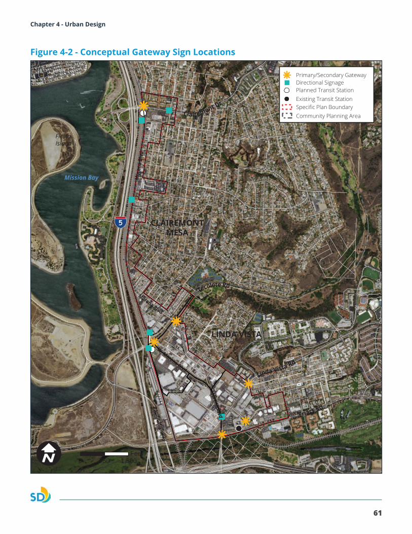
61
Morena Corridor Specific Plan Chapter 4 - Urban Design
CLAIREMONT MESA
LINDA VISTA
Fiesta Island
Mission Bay
W. Morena Blvd
Morena Blvd
Morena Blvd
Mor
ena
Blvd
Pacific Highway
Clairemont Dr
Tecolote Rd
Linda Vista Rd
Friars Rd
Primary/Secondary GatewayDirectional SignagePlanned Transit Station
Specific Plan BoundaryCommunity Planning Area
Existing Transit Station
0 1,500750FeetI
Figure 4-2 - Conceptual Gateway Sign Locations
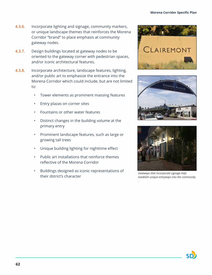
62
Morena Corridor Specific Plan
4.3.6. Incorporate lighting and signage, community markers, or unique landscape themes that reinforces the Morena Corridor “brand” to place emphasis at community gateway nodes.
4.3.7. Design buildings located at gateway nodes to be oriented to the gateway corner with pedestrian spaces, and/or iconic architectural features.
4.3.8. Incorporate architecture, landscape features, lighting, and/or public art to emphasize the entrance into the Morena Corridor which could include, but are not limited to:
• Tower elements as prominent massing features
• Entry plazas on corner sites
• Fountains or other water features
• Distinct changes in the building volume at the primary entry
• Prominent landscape features, such as large or growing tall trees
• Unique building lighting for nighttime effect
• Public art installations that reinforce themes reflective of the Morena Corridor
• Buildings designed as iconic representations of their dstrict’s character
Gateways that incorporate signage help establish unique entryways into the community. .
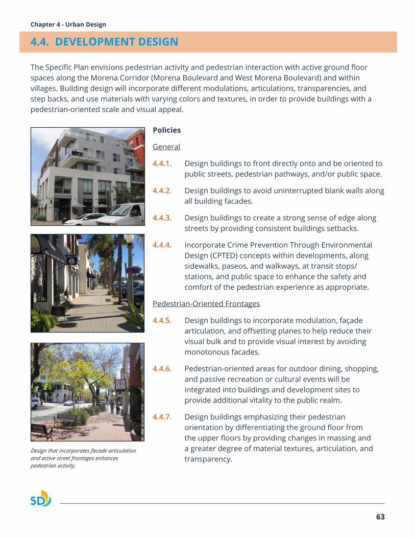
63
Morena Corridor Specific Plan Chapter 4 - Urban Design
4.4. DEVELOPMENT DESIGN
The Specific Plan envisions pedestrian activity and pedestrian interaction with active ground floor spaces along the Morena Corridor (Morena Boulevard and West Morena Boulevard) and within villages. Building design will incorporate different modulations, articulations, transparencies, and step backs, and use materials with varying colors and textures, in order to provide buildings with a pedestrian-oriented scale and visual appeal.
Policies
General
4.4.1. Design buildings to front directly onto and be oriented to public streets, pedestrian pathways, and/or public space.
4.4.2. Design buildings to avoid uninterrupted blank walls along all building facades.
4.4.3. Design buildings to create a strong sense of edge along streets by providing consistent buildings setbacks.
4.4.4. Incorporate Crime Prevention Through Environmental Design (CPTED) concepts within developments, along sidewalks, paseos, and walkways, at transit stops/stations, and public space to enhance the safety and comfort of the pedestrian experience as appropriate.
Pedestrian-Oriented Frontages
4.4.5. Design buildings to incorporate modulation, façade articulation, and offsetting planes to help reduce their visual bulk and to provide visual interest by avoiding monotonous facades.
4.4.6. Pedestrian-oriented areas for outdoor dining, shopping, and passive recreation or cultural events will be integrated into buildings and development sites to provide additional vitality to the public realm.
4.4.7. Design buildings emphasizing their pedestrian orientation by differentiating the ground floor from the upper floors by providing changes in massing and a greater degree of material textures, articulation, and transparency.
Design that incorporates facade articulation and active street frontages enhances pedestrian activity.
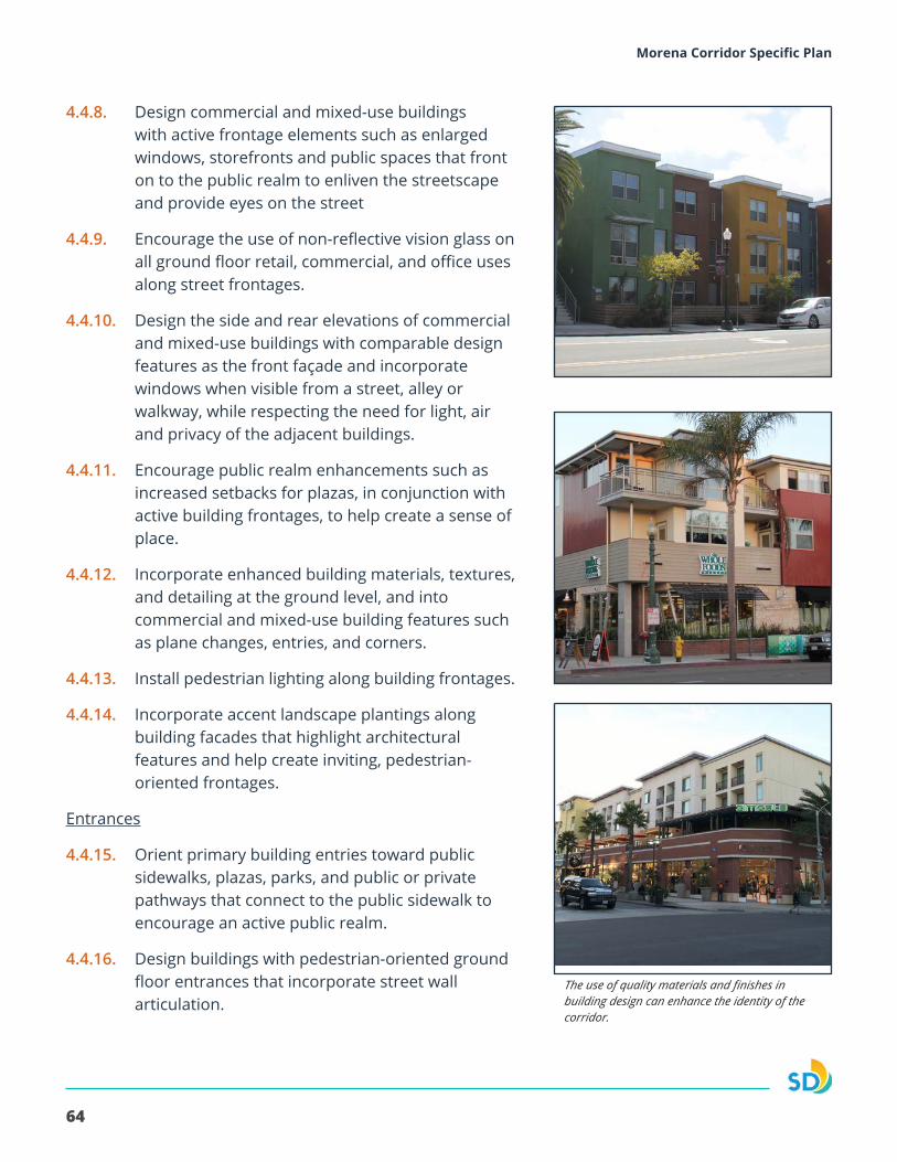
64
Morena Corridor Specific Plan
4.4.8. Design commercial and mixed-use buildings with active frontage elements such as enlarged windows, storefronts and public spaces that front on to the public realm to enliven the streetscape and provide eyes on the street
4.4.9. Encourage the use of non-reflective vision glass on all ground floor retail, commercial, and office uses along street frontages.
4.4.10. Design the side and rear elevations of commercial and mixed-use buildings with comparable design features as the front façade and incorporate windows when visible from a street, alley or walkway, while respecting the need for light, air and privacy of the adjacent buildings.
4.4.11. Encourage public realm enhancements such as increased setbacks for plazas, in conjunction with active building frontages, to help create a sense of place.
4.4.12. Incorporate enhanced building materials, textures, and detailing at the ground level, and into commercial and mixed-use building features such as plane changes, entries, and corners.
4.4.13. Install pedestrian lighting along building frontages.
4.4.14. Incorporate accent landscape plantings along building facades that highlight architectural features and help create inviting, pedestrian-oriented frontages.
Entrances
4.4.15. Orient primary building entries toward public sidewalks, plazas, parks, and public or private pathways that connect to the public sidewalk to encourage an active public realm.
4.4.16. Design buildings with pedestrian-oriented ground floor entrances that incorporate street wall articulation.
The use of quality materials and finishes in building design can enhance the identity of the corridor.
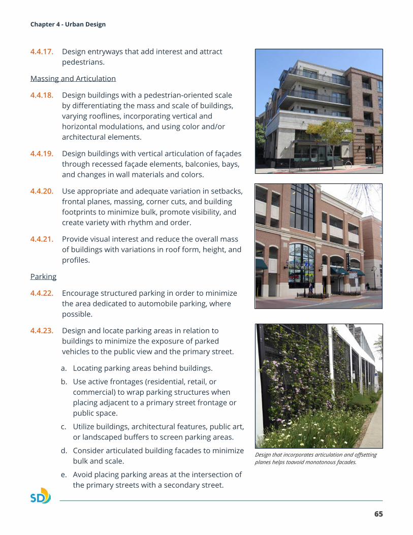
65
Morena Corridor Specific Plan Chapter 4 - Urban Design
4.4.17. Design entryways that add interest and attract pedestrians.
Massing and Articulation
4.4.18. Design buildings with a pedestrian-oriented scale by differentiating the mass and scale of buildings, varying rooflines, incorporating vertical and horizontal modulations, and using color and/or architectural elements.
4.4.19. Design buildings with vertical articulation of façades through recessed façade elements, balconies, bays, and changes in wall materials and colors.
4.4.20. Use appropriate and adequate variation in setbacks, frontal planes, massing, corner cuts, and building footprints to minimize bulk, promote visibility, and create variety with rhythm and order.
4.4.21. Provide visual interest and reduce the overall mass of buildings with variations in roof form, height, and profiles.
Parking
4.4.22. Encourage structured parking in order to minimize the area dedicated to automobile parking, where possible.
4.4.23. Design and locate parking areas in relation to buildings to minimize the exposure of parked vehicles to the public view and the primary street.
a. Locating parking areas behind buildings.
b. Use active frontages (residential, retail, or commercial) to wrap parking structures when placing adjacent to a primary street frontage or public space.
c. Utilize buildings, architectural features, public art, or landscaped buffers to screen parking areas.
d. Consider articulated building facades to minimize bulk and scale.
e. Avoid placing parking areas at the intersection of the primary streets with a secondary street.
Design that incorporates articulation and offsetting planes helps toavoid monotonous facades.
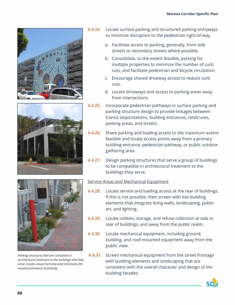
66
Morena Corridor Specific Plan
4.4.24. Locate surface parking and structured parking entryways to minimize disruption to the pedestrian right-of-way.
a. Facilitate access to parking, generally, from side streets or secondary streets where possible.
b. Consolidate, to the extent feasible, parking for multiple properties to minimize the number of curb cuts, and facilitate pedestrian and bicycle circulation.
c. Encourage shared driveway access to reduce curb cuts.
d. Locate driveways and access to parking areas away from intersections
4.4.25. Incorporate pedestrian pathways in surface parking and parking structure design to provide linkages between transit stops/stations, building entrances, retail uses, parking areas, and streets.
4.4.26. Share parking and loading access to the maximum extent feasible and locate access points away from a primary building entrance, pedestrian pathway, or public outdoor gathering area.
4.4.27. Design parking structures that serve a group of buildings to be compatible in architectural treatment to the buildings they serve.
Service Areas and Mechanical Equipment
4.4.28. Locate service and loading access at the rear of buildings. If this is not possible, then screen with low building elements that integrate living walls, landscaping, public art, and lighting.
4.4.29. Locate utilities, storage, and refuse collection at side or rear of buildings, and away from the public realm.
4.4.30. Locate mechanical equipment, including ground, building, and roof-mounted equipment away from the public view.
4.4.31. Screen mechanical equipment from the street frontage with building elements and landscaping that are consistent with the overall character and design of the building facades.
Parking structures that are consistent in architectural treatment to the buildings that theyserve creates visual harmony and minimizes the visual prominence of parking.
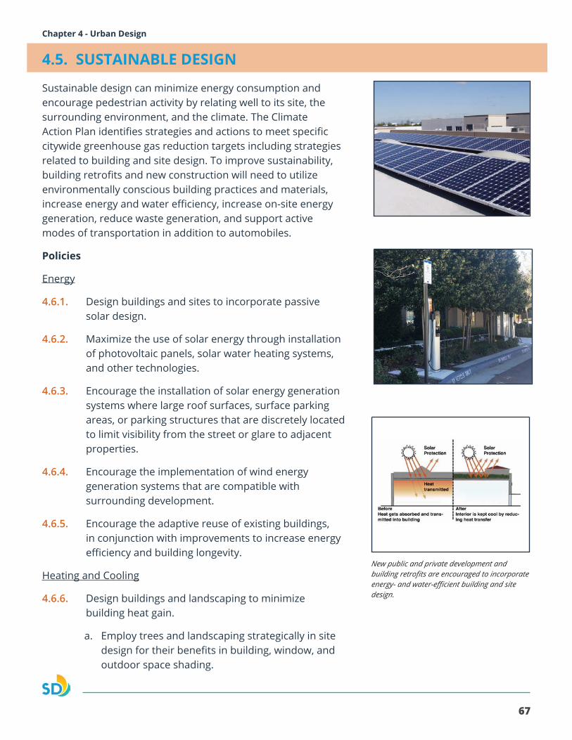
67
Morena Corridor Specific Plan Chapter 4 - Urban Design
4.5. SUSTAINABLE DESIGN
Sustainable design can minimize energy consumption and encourage pedestrian activity by relating well to its site, the surrounding environment, and the climate. The Climate Action Plan identifies strategies and actions to meet specific citywide greenhouse gas reduction targets including strategies related to building and site design. To improve sustainability, building retrofits and new construction will need to utilize environmentally conscious building practices and materials, increase energy and water efficiency, increase on-site energy generation, reduce waste generation, and support active modes of transportation in addition to automobiles.
Policies
Energy
4.6.1. Design buildings and sites to incorporate passive solar design.
4.6.2. Maximize the use of solar energy through installation of photovoltaic panels, solar water heating systems, and other technologies.
4.6.3. Encourage the installation of solar energy generation systems where large roof surfaces, surface parking areas, or parking structures that are discretely located to limit visibility from the street or glare to adjacent properties.
4.6.4. Encourage the implementation of wind energy generation systems that are compatible with surrounding development.
4.6.5. Encourage the adaptive reuse of existing buildings, in conjunction with improvements to increase energy efficiency and building longevity.
Heating and Cooling
4.6.6. Design buildings and landscaping to minimize building heat gain.
a. Employ trees and landscaping strategically in site design for their benefits in building, window, and outdoor space shading.
New public and private development and building retrofits are encouraged to incorporate energy- and water-efficient building and site design.
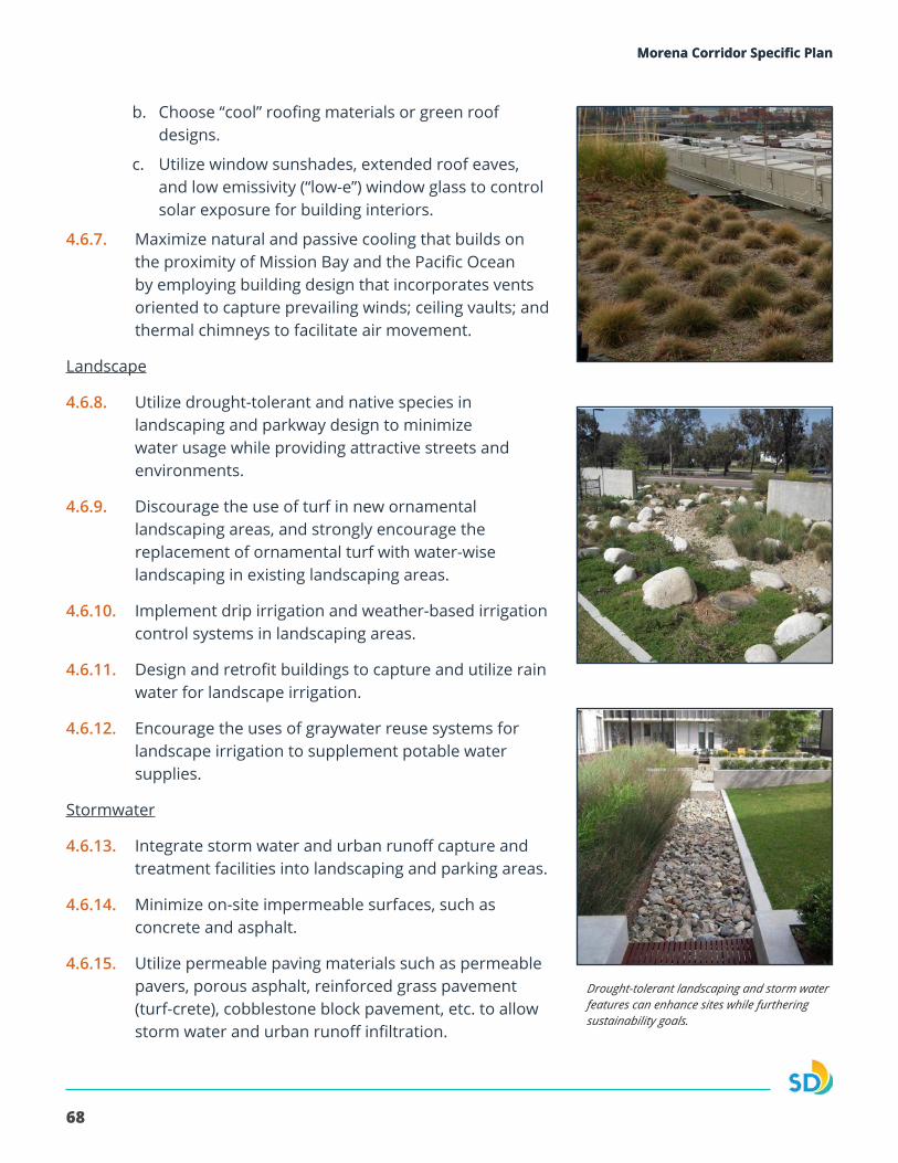
68
Morena Corridor Specific PlanMorena Corridor Specific Plan
b. Choose “cool” roofing materials or green roof designs.
c. Utilize window sunshades, extended roof eaves, and low emissivity (“low-e”) window glass to control solar exposure for building interiors.
4.6.7. Maximize natural and passive cooling that builds on the proximity of Mission Bay and the Pacific Ocean by employing building design that incorporates vents oriented to capture prevailing winds; ceiling vaults; and thermal chimneys to facilitate air movement.
Landscape
4.6.8. Utilize drought-tolerant and native species in landscaping and parkway design to minimize water usage while providing attractive streets and environments.
4.6.9. Discourage the use of turf in new ornamental landscaping areas, and strongly encourage the replacement of ornamental turf with water-wise landscaping in existing landscaping areas.
4.6.10. Implement drip irrigation and weather-based irrigation control systems in landscaping areas.
4.6.11. Design and retrofit buildings to capture and utilize rain water for landscape irrigation.
4.6.12. Encourage the uses of graywater reuse systems for landscape irrigation to supplement potable water supplies.
Stormwater
4.6.13. Integrate storm water and urban runoff capture and treatment facilities into landscaping and parking areas.
4.6.14. Minimize on-site impermeable surfaces, such as concrete and asphalt.
4.6.15. Utilize permeable paving materials such as permeable pavers, porous asphalt, reinforced grass pavement (turf-crete), cobblestone block pavement, etc. to allow storm water and urban runoff infiltration.
Drought-tolerant landscaping and storm water features can enhance sites while furtheringsustainability goals.
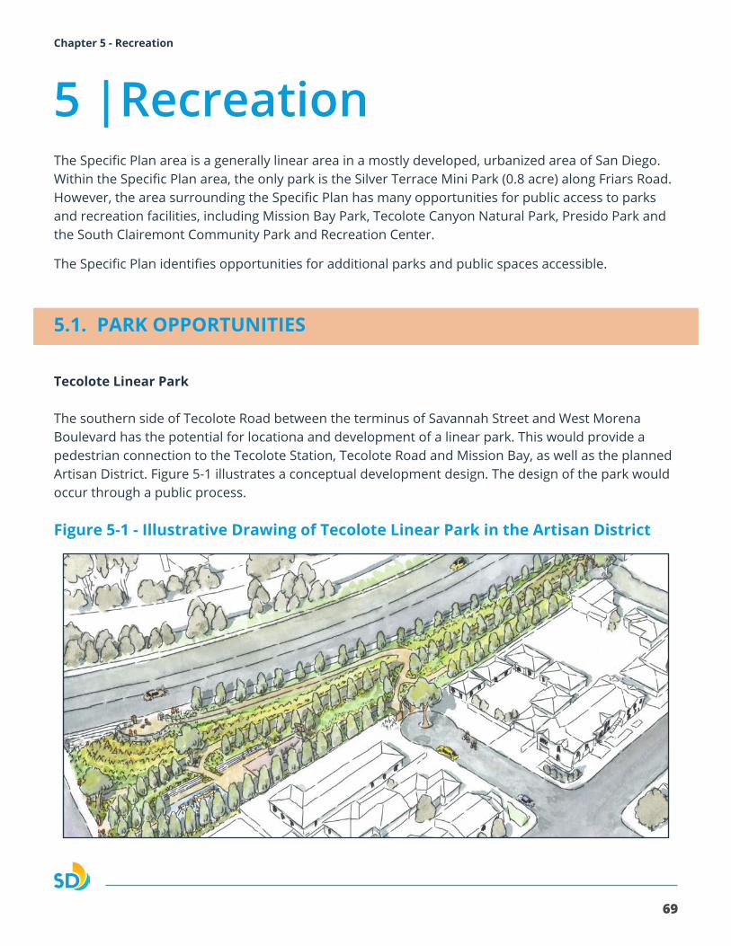
69
Morena Corridor Specific Plan Chapter 5 - RecreationMorena Corridor Specific Plan
The Specific Plan area is a generally linear area in a mostly developed, urbanized area of San Diego. Within the Specific Plan area, the only park is the Silver Terrace Mini Park (0.8 acre) along Friars Road. However, the area surrounding the Specific Plan has many opportunities for public access to parks and recreation facilities, including Mission Bay Park, Tecolote Canyon Natural Park, Presido Park and the South Clairemont Community Park and Recreation Center.
The Specific Plan identifies opportunities for additional parks and public spaces accessible.
5.1. PARK OPPORTUNITIES
Tecolote Linear Park
The southern side of Tecolote Road between the terminus of Savannah Street and West Morena Boulevard has the potential for locationa and development of a linear park. This would provide a pedestrian connection to the Tecolote Station, Tecolote Road and Mission Bay, as well as the planned Artisan District. Figure 5-1 illustrates a conceptual development design. The design of the park would occur through a public process.
Figure 5-1 - Illustrative Drawing of Tecolote Linear Park in the Artisan District
5 |Recreation
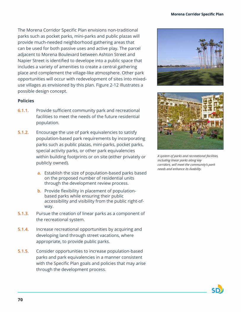
70
Morena Corridor Specific PlanMorena Corridor Specific Plan
The Morena Corridor Specific Plan envisions non-traditional parks such as pocket parks, mini-parks and public plazas will provide much-needed neighborhood gathering areas that can be used for both passive uses and active play. The parcel adjacent to Morena Boulevard between Ashton Street and Napier Street is identified to develope into a public space that includes a variety of amenities to create a central gathering place and complement the village-like atmosphere. Other park opportunities will occur with redevelopment of sites into mixed-use villages as envisioned by this plan. Figure 2-12 illustrates a possible design concept.
Policies
6.1.1. Provide sufficient community park and recreational facilities to meet the needs of the future residential population.
5.1.2. Encourage the use of park equivalencies to satisfy population-based park requirements by incorporating parks such as public plazas, mini-parks, pocket parks, special activity parks, or other park equivalencies within building footprints or on site (either privately or publicly owned).
a. Establish the size of population-based parks based on the proposed number of residential units through the development review process.
b. Provide flexibility in placement of population-based parks while ensuring their public accessibility and visibility from the public right-of-way.
5.1.3. Pursue the creation of linear parks as a component of the recreational system.
5.1.4. Increase recreational opportunities by acquiring and developing land through street vacations, where appropriate, to provide public parks.
5.1.5. Consider opportunities to increase population-based parks and park equivalencies in a manner consistent with the Specific Plan goals and policies that may arise through the development process.
A system of parks and recreational facilities, including linear parks along keycorridors, will meet the community’s park needs and enhance its livability.
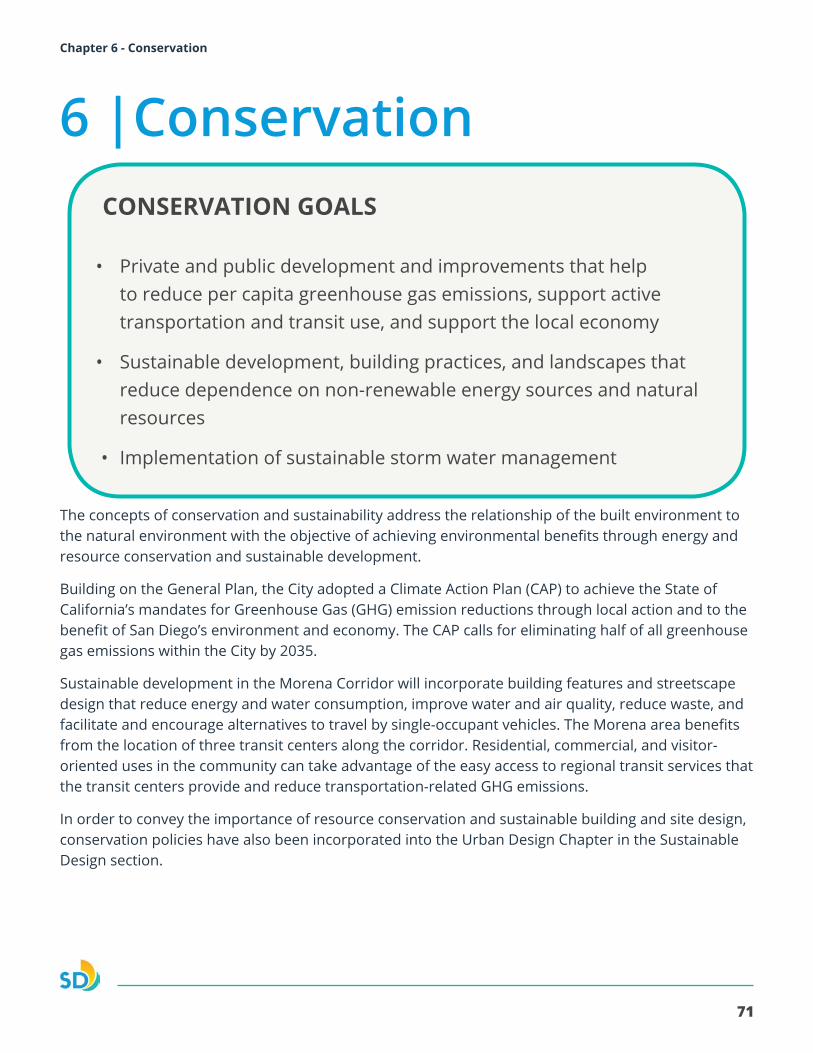
71
Morena Corridor Specific Plan Chapter 6 - ConservationMorena Corridor Specific Plan
The concepts of conservation and sustainability address the relationship of the built environment to the natural environment with the objective of achieving environmental benefits through energy and resource conservation and sustainable development.
Building on the General Plan, the City adopted a Climate Action Plan (CAP) to achieve the State of California’s mandates for Greenhouse Gas (GHG) emission reductions through local action and to the benefit of San Diego’s environment and economy. The CAP calls for eliminating half of all greenhouse gas emissions within the City by 2035.
Sustainable development in the Morena Corridor will incorporate building features and streetscape design that reduce energy and water consumption, improve water and air quality, reduce waste, and facilitate and encourage alternatives to travel by single-occupant vehicles. The Morena area benefits from the location of three transit centers along the corridor. Residential, commercial, and visitor-oriented uses in the community can take advantage of the easy access to regional transit services that the transit centers provide and reduce transportation-related GHG emissions.
In order to convey the importance of resource conservation and sustainable building and site design, conservation policies have also been incorporated into the Urban Design Chapter in the Sustainable Design section.
6 |ConservationCONSERVATION GOALS
• Private and public development and improvements that help to reduce per capita greenhouse gas emissions, support active transportation and transit use, and support the local economy
• Sustainable development, building practices, and landscapes that reduce dependence on non-renewable energy sources and natural resources
• Implementation of sustainable storm water management
72
Morena Corridor Specific Plan
6.1. Sustainable Development
Sustainable development has a renewed importance due to the visible effects of global climate change resulting from greenhouse gas emissions, as well as State and local. Potential impacts of a changing climate – higher seasonal temperatures, diminished water supplies, disruption of agricultural cycles – affect the built and natural environment and the Morena Corridor’s health and economic vitality.
The General Plan’s goals and policies regarding climate change and natural resources aim for a balance between natural resources and economic prosperity while protecting the public health, safety, and welfare of residents by making our built environment more resilient and healthy. The CAP provides a package of policies with steps the City can take to achieve the 2035 GHG emissions reductions targets and address climate change. The CAP supports implementation of the General Plan through support for continued incremental changes to the urban land use and urban form, providing a greater variety of transportation choices, and transforming how we produce and use energy and water. Further, the CAP will complement the General Plan policies to reduce greenhouse gas emissions with quantifiable data and benchmarks for success.
The CAP policies and actions are organized around the following five strategies:
1. Energy & water efficient buildings
2. Clean & renewable energy
3. Bicycle, walking, transit & land use
4. Zero waste
5. Climate resilience
The CAP’s mobility and land use strategy aims to expand bicycling, walking, and transit use as alternatives to automobile trips, particularly for work commute trips. The strategy’s land use component would advance the General Plan’s “City of Villages” concept of walkable and pedestrian-friendly neighborhoods with a mix of uses. The Morena Corridor is well-positioned to reduce dependence on the private automobile due to the community’s central location in the region, walkable size, and access to transit services. A majority of the specific plan area is within a Transit Priority Area (TPA), defined as an area with half-mile walking distance of a major transit stop, which makes public transit a viable transportation option. The land use plan (Figure 2-1) implements the CAP’s land use and mobility strategy by designing areas for higher density housing within the TPA.
73
Morena Corridor Specific Plan Chapter 6 - Conservation
The Specific Plan identifies bicycle and pedestrian facility improvements that complement the land use strategy to provide housing growth opportunities within TPAs. The Specific Plan establishes a modified grid network that facilitates shifting trips to transit, walking, and bicycling, while also accommodating vehicle traffic and minimizing conflicts between travel modes. The identified mobility improvements include intersection, sidewalk, and roadway improvements to increase accessibility and improve bicycle and pedestrian access. The identified infrastructure improvements, as well as the interconnectedness of the bicycle and pedestrian network to the transit stations will support the Morena Corridor’s residential and employment capacity with less increase in per capita vehicle emissions.
Sustainable development practices will implement the other CAP strategies and help meet the CAP’s GHG emissions reduction goals. Modern sustainable building features can include alternative building materials, energy and water conservation systems, and alternative sources of energy.
Policies
6.1.1. Reduce greenhouse gas emissions through a wide range of actions consistent with the General Plan and Climate Action Plan.
a. Implement pedestrian and bicycle infrastructure improvements in Transit Priority Areas to increase commuter walking and bicycling opportunities.
b. Support higher density/intensity housing and employment development in Transit Priority Areas to increase transit ridership.
c. Provide additional bicycle and pedestrian improvements in coordination with street resurfacing as feasible.
d. Coordinate with San Diego Association of Governments to identify transit right-of-way and priority measures to support existing and planned transit routes, prioritizing for implementation the highest priority bicycle and pedestrian improvements.
e. Support regional improvements that promote alternative modes of transportation, such as mobility hubs.
f. Provide bicycle- and car-sharing programs and their facilities such as bicycle-sharing stations and car-sharing vehicle access points.
g. Retime traffic signals and installing roundabouts where needed to reduce vehicle fuel consumption.
h. Apply the CAP consistency checklist as a part of the development permit review process, as applicable.
i. Support and implement improvements to enhance transit accessibility and operations, as feasible.
j. Monitor the mode share within the Specific Plan’s TPAs to support the CAP Annual Monitoring Report Program.
6.1.2. Implement mobility measures that reduce dependence on single-occupant vehicle use, increase fuel efficiency and promote the use of alternative more sustainable energy sources.
74
Morena Corridor Specific Plan
6.1.3. Promote car and bicycle sharing programs as cost-effective alternatives to car ownership for residents and employees.
6.1.4. Encourage community organizations and businesses to educate residents, employees and visitors about the accessibility of transit, community destinations, and regional recreational resources via walking and bicycling.
6.1.5. Promote the continued use or adaptive reuse of existing buildings in conjunction with any needed renovations to increase their energy efficiency as part of a comprehensive energy use reduction strategy.
6.1.6. Ensure that development is consistent with General Plan and Community Plan sustainability policies and supports implementation of the Climate Action Plan.
a. Reduce development project-level greenhouse gas emissions to acceptable levels by incorporating sustainable building and development practices (refer to Urban Design Element, Building Design: Sustainability section), applying site-specific mitigation measures, and adhering to specific strategies and actions outlined in the Climate Action Plan.
b. Encourage the adherence to LEED standards for construction to achieve environmental benefits through new development and redevelopment projects.
6.1.7. Improve energy and water conservation in the operation and design of existing and new public facilities and public landscaping areas.
6.1.8. Encourage the implementation of energy- and water-efficient measures for commercial uses that exceed California Code, such as energy-efficient and water-efficient machinery for laundry operations; energy-efficient and water-efficient kitchens in restaurants; and storefront shading.
6.1.9. Encourage new development and building retrofits to incorporate as many water-wise practices as possible.
a. Encourage the replacement of existing ornamental lawns with native and drought-tolerant landscaping (see also Urban Design Element, Urban Forestry & Landscaping section).
b. Encourage use of recycled and/or graywater landscape irrigation systems;
c. Ensure that any community greening or community garden projects utilize water-efficient landscape and irrigation design.
6.1.10. Encourage residential, commercial, and institutional development to implement composting for landscaping waste and compatible food waste.
6.1.11. Encourage restaurant uses to participate in commercial food waste recycling programs and utilize eco-friendly take-out containers and reusable drink containers without plastic straws.
75
Morena Corridor Specific Plan Chapter 6 - Conservation
6.1.12. Increase the community’s overall tree canopy within the public right-of-way and development sites to provide air quality benefits and urban runoff management.
6.1.13. Design and construct development to retain significant, mature and healthy trees located within required landscape setbacks, and within other portions of the site as feasible (also refer to Urban Design Chapter).
6.1.14. Ensure street trees are provided with new development where adequate right-of-way exists.
6.1.15. Plant or replace street trees to fill existing gaps and provide continuous, regularly spaced tree canopies.
6.2. Urban Runoff Management
Urbanization and development alter and inhibit the natural hydrologic process of surface water infiltration, percolation to groundwater, evapotranspiration, and transpiration. Urban runoff is surface water runoff generated from developed or disturbed land, and storm water is one significant type of urban runoff. Increases in impervious surfaces lead to fewer opportunities for water runoff to infiltrate into the ground. This increases the magnitude and duration of storm water flows, contributing to urban flooding, and results in sediment and pollutants entering watersheds and downstream waterbodies. Urban runoff is the largest pollution source of San Diego’s coastal beaches and near shore waters.
Improvements in the management of storm water runoff can help address flooding in the community during wet weather and assist regional efforts to protect water quality within streams, bays, and the ocean. Low Impact Development (LID) techniques are approaches to storm water and urban runoff management that increase the ability of water to infiltrate into the ground. LID techniques that can be implemented through development projects include reduction of impermeable surfaces and installation of bio-infiltration and bio-retention areas, green roofs, and permeable pavement. Incorporation of storm water management facilities in the public right-of-way will further improve storm water management along the Morena Corridor.
Policies
6.2.1. Incorporate Low Impact Development practices into building design and site plans that work with the natural hydrology of a site to reduce urban runoff, including the design or retrofit of existing landscaped or impervious areas to better capture storm water runoff.
6.2.2. Incorporate and maintain storm water best management practices in public infrastructure and private development projects, including streetscape improvements to limit water pollution, erosion, and sedimentation.
6.2.3. Prioritize Low Impact Development practices that encourage water infiltration to minimize reliance on storm drains that could be impaired by sea level rise.
76
Morena Corridor Specific PlanMorena Corridor Specific Plan
This page is intentionally left blank
77
Morena Corridor Specific Plan Chapter 7 - Infrastructure, Public Facilities and ServicesMorena Corridor Specific Plan
The Morena Corridor is a developed area with basic infrastructure and facilities. Certain utilities may need to be expanded to serve futurel growth.
7.1. Water
Water lines are generally located in the public streets and range in size from 5 to 16 inches. The Specific Plan area is primarily served by a 16-inch main running the length of Morena Boulevard, which connects to a 16-inch main in Friars Road. Other large water lines in the area include 12-inch lines in Cushman Avenue, Knoxville Street, Littlefield Street, Milton Street, Jellett Street, and Gesner Street. The water lines are primarily made of cast iron (CI), asbestos cement (AC), and poly-vinyl chloride (PVC).
The City PUD has planned maintenance that will upgrade/replace some of the older and undersized water lines in the Specific Plan area. This work is scheduled to be completed from 2018 to 2023. This work includes replacing the 16-inch CI line in Morena Boulevard with a 16-inch PVC line and replacing numerous AC lines with PVC. Where the existing AC lines are undersized, the new PVC lines will be upsized to meet current standards. The City currently requires an 8-inch-minimum diameter for public water mains, with a 12-inch minimum in commercial zones to meet fire flow requirements.
Implementation of the Specific Plan could require upgrades to the existing water system infrastructure to ensure adequate capacity and sufficient fire flow.
7 |Infrastructure, Public Facilities and Services
78
Morena Corridor Specific Plan
7.2. Wastewater
Lines in the existing sewer system in the Specific Plan area can be divided into two classes: small mains and trunk sewers. The small mains form the collection system and convey sewer flows from individual properties to the trunk sewers. The trunk sewers are larger sewer lines that convey flows from multiple small mains as well as from adjacent neighborhoods.
The small mains are 8 to 15 inches in diameter and made of vitrified clay (VC) and PVC. Generally, the small mains are considered to operate within their capacity, with no capacity-related issues in the project area. Similar to the water system, the City has identified required maintenance and upgrades for the sewer system. Sewer lines that have been inspected were identified as requiring routine maintenance only, point repair, rehabilitation, or replacement.
The major trunk sewers include lines in Morena Boulevard, Anna Avenue, Tecolote Road, Lehigh Street, Frankfort Street, and Ingulf Street. To assess the capacity of the trunk sewers to accept a potential increase in flows from the project area, the 2012 and 2025 flow data was examined. Implementation of the Specific Plan could require upgrades to the existing wastewater system infrastructure to ensure adequate capacity and sufficient flow.
7.3. Stormwater
The topography of the Specific Plan area generally falls from east to west, which is the direction of storm drain flow. The public storm drain system in the Specific Plan area has been divided into six drainage basins based on discharge points. Basin A consists of the southeastern portion of the Specific Plan area that drains to the San Diego River. Runoff in this area is collected by storm drains that convey flows southwest to the river. Basin B is in the southwest portion of the Specific Plan area and drains to a 60-inch-diameter storm drain that discharges to an open channel along I-5.
Basin C drains to Tecolote Creek via multiple underground storm drains and includes the south- central portion of the Specific Plan area both north and south of Tecolote Creek. Basin D is in the north-central portion of the Specific Plan area and ultimately discharges to Mission Bay via multiple underground storm drains. Basins E and F are in the northern portion of the Specific Plan area and drain to large-diameter storm drains that also collect runoff from the offsite areas to the east. The storm drains in Basins E and F both discharge to Mission Bay.
79
Morena Corridor Specific Plan Chapter 7 - Infrastructure, Public Facilities and Services
7.4. Dry Utilities
Telecommunications and Cable ServiceCommunications systems for telephone, computers, and cable television for the Specific Plan area are serviced by utility providers such as AT&T, Cox, and other independent telecommunications companies. The City also works with service providers to underground overhead wires, cables, conductors, and other structures associated with communication systems in residential areas in accordance with proposed development projects.
Energy (Electricity and Natural Gas)San Diego Gas and Electric Company (SDG&E) is responsible for supply, transmission, and distribution of electricity and natural gas to customers in the Specific Plan area.
7.5. Public Facilities
Library The City of San Diego’s Public Library system has two libraries that serve the Specific Plan area: the Clairemont Library (2920 Burgener Blvd.) further east along Clairemont Drive, and the Linda Vista Library (2160 Ulric St.) further east off of Linda Vista Road.
Public SchoolsThe San Diego Unified School District provides kindergarten to 12th grade schools that serve the Specific Plan area: Bay Park Elementary School (K-5th grade), Marston Middle School (6th-8th grade), and Clairemont High School (9th-12th grade).
PoliceThe San Diego Police Department (SDPD) provides police services that include patrol, traffic, investigative, records, laboratory, and support services. The SDPD Western Division station is in the Specific Plan area on Gaines Street. The Western Division serves the portion of the Specific Plan area south of Tecolote Road, within Beat 622-Morena. The Northern Division serves the northern portion of the Specific Plan area, north of Tecolote Road within Beat 116-Bay Park.
Fire/Emergency ServicesThe Specific Plan area is serviced by San Diego Fire-Rescue Station 25 at 1972 Chicago Street. Fire Station 25 has a battalion chief’s vehicle and an engine. The engine responds to both fire and medical incidents. Rural/Metro San Diego is contracted with the City to provide emergency medical services.
Solid WasteThe City’s Environmental Services Department provides refuse, recycling, and yard waste collection and disposal services to primarily single-family homes as well as some multifamily and commercial/ business customers. Most multifamily residences and commercial and industrial business customers are not served by the City and are required to fund and contract directly with private haulers for trash and recycling collection.
80
Morena Corridor Specific PlanMorena Corridor Specific Plan
This page is intentionally left blank.
81
Morena Corridor Specific Plan Chapter 8 - ImplementationMorena Corridor Specific Plan
8.1. Purpose
The Land Development Code (LDC) establishes procedures to standardize the review process for the adoption of new land use plans and the privately or publicly initiated amendment of adopted land use plans. Land use plans include specific plans, the General Plan and community plans.
The LDC establishes specific plan requirements by referencing the California Government Code sections for specific plans. California Government Code requires that a specific plan be consistent with the adopted General Plan. All subsequent development proposals, such as tentative subdivision maps, site plans, improvement plans, and all public works projects must be consistent with the specific plan.
The Morena Corridor Specific Plan contains both policies and regulations. The supplemental development regulations only apply to the village areas in the Linda Vista portion of the Specific Plan area. In any instance where the Specific Plan conflicts with the requirements of the LDC, the Specific Plan supplemental development regulations takes precedence. Where the Specific Plan supplemental development regulations are silent on a topic, the LDC requirements remain in effect.
8.2. Severability
If any section, subsection, sentence, clause, phrase, or portion of the Specific Plan, or any future amendments or additions hereto, is for any reason found to be invalid or unconstitutional by the decision of any court of competent jurisdiction, such decision shall not affect the validity of the remainder of the Specific Plan document or any future amendments or additions hereto. The City hereby declares that it would have adopted these requirements and each sentence, subsection, clause, phrase, or portion or any future amendments or additions thereto, irrespective of the fact that any one or more section, subsections, clauses, phrases, portions, or any future amendments or additions thereto may be declared invalid or unconstitutional.
8 |Implementation
82
Morena Corridor Specific Plan
8.3. Administration
The Development Services Director has the responsibility and authority to interpret the Specific Plan. Whenever the Development Services Director makes an official interpretation of the Specific Plan, the interpretation shall be made in writing explaining the interpretation and the general circumstances surrounding the need for the interpretation. Any interpretation by the Development Services Director may be appealed to the Planning Commission for a decision at a public meeting. The Development Services Director may refer interpretation of the Specific Plan to the Planning Commission for a decision at a public meeting.
8.4. Environmental Review
Adoption of the Specific Plan has the potential for streamlining environmental review. A CEQA exemption could apply if a project meets all of the following criteria:
• Project is a residential, employment center, or mixed use project;
• Project is located within a transit priority area;
• Project is consistent with a specific plan for which an environmental impact report was certified; and
• Project is consistent with an adopted sustainable communities strategy or alternative planning strategy.
The exemption cannot be applied if the project would cause new or worse significant impacts compared to what was analyzed in the environmental impact report for the Specific Plan. In that case, supplemental environmental review must be prepared.
8.5. Land Development Code
The Land Development Code (LDC) is part of the City of San Diego Municipal Code and contains base zoning designations and overlay zones with development regulations pertaining to uses, density, and floor area, setbacks, landscaping, and other development characteristics that implement the Specific Plan. The development regulations and within the Land Development Code apply to development and property within the Specific Plan area.
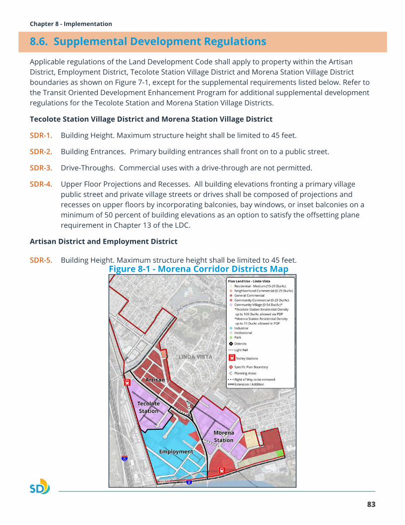
83
Morena Corridor Specific Plan Chapter 8 - Implementation
8.6. Supplemental Development Regulations
Applicable regulations of the Land Development Code shall apply to property within the Artisan District, Employment District, Tecolote Station Village District and Morena Station Village District boundaries as shown on Figure 7-1, except for the supplemental requirements listed below. Refer to the Transit Oriented Development Enhancement Program for additional supplemental development regulations for the Tecolote Station and Morena Station Village Districts.
Tecolote Station Village District and Morena Station Village District
SDR-1. Building Height. Maximum structure height shall be limited to 45 feet.
SDR-2. Building Entrances. Primary building entrances shall front on to a public street.
SDR-3. Drive-Throughs. Commercial uses with a drive-through are not permitted.
SDR-4. Upper Floor Projections and Recesses. All building elevations fronting a primary village public street and private village streets or drives shall be composed of projections and recesses on upper floors by incorporating balconies, bay windows, or inset balconies on a minimum of 50 percent of building elevations as an option to satisfy the offsetting plane requirement in Chapter 13 of the LDC.
Artisan District and Employment District
SDR-5. Building Height. Maximum structure height shall be limited to 45 feet.Figure 8-1 - Morena Corridor Districts Map
84
Morena Corridor Specific Plan
Transit-Oriented Development Enhancement Program
The Transit-Oriented Development Enhancement Program can be utilized within lands designated Community Village (0-54 Du/Ac) in the Tecolote Station and Morena Station Districts as shown on Figure 2-1. The intent of the Transit-Oriented Development Enhancement Program is to allow for increased residential density, to create transit-oriented development that supports the implementation of the CAP and implements the Mobility and Urban Design policies of the Specific Plan. The Transit-Oriented Development Enhancement Program allows for the density range for this area to be increased up to 109 dwelling units per acre in the Tecolote Station District, and 73 dwelling units per acre in the Morena Station District, whereby an applicant may request approval of the increased density on a specific property through a Planned Development Permit. A project using the Transit-Oriented Development Enhancement Program must be consistent with the Specific Plan Urban Design and Mobility policies and conform with the requirements set forth in Section 143.0402 of the LDC for PDP’s, and may be approved only if the decision maker makes the findings in LDC Section 126.0604(a).
Tecolote Station Village District
SDR-6. Allow for residential development up to 109 du/acre through a Planned Development Permit
a. Allow for a maximum structure height of 100 feet.
b. Allow for a maximum floor area ratio of 5.0 for Residential Mixed-Use Development.
Morena Station Village District
SDR-7. Allow for residential development up to 73 du/acre through a Planned Development Permit
a. Allow for a maximum structure height of 65 feet.
b. Allow for a maximum floor area ratio of 4.5 for Residential Mixed-Use Development.
85
Morena Corridor Specific Plan Chapter 8 - Implementation
8.7. Affordable Housing Density Bonus Regulations
The Transit-Oriented Development Enhancement Program, described above, is separate from the City’s Affordable Housing Density Bonus Regulations in Land Development Code (LDC) Chapter 14, Article 3, Division 7 that is subject to State of California’s Affordable Housing Density Bonus Program. The Affordable Housing Density Bonus Program is available to eligible development citywide. Applicants are eligible to apply for the State of California’s Affordable Housing Density Bonus Program once the maximum allowable residential density per the Specific Plan is achieved, application for a Planned Development Permit is not required. The maximum allowable residential density per the Specific Plan means the maximum allowable residential density for the designated zoning ranges without the additional density available through the Transit-Oriented Development Enhancement Program. However, should an applicant apply for and obtain the increased density under the Transit-Oriented Development Enhancement Program, the maximum allowable residential density for the Affordable Housing Density Bonus Program shall include the increased density dwelling units from the Transit-Oriented Development Enhancement Program.
8.8. Specific Plan Amendments
Administrative ModificationsAdministrative Modifications may be administratively approved by the Development Services Director if they are minor in nature, conform with the adopted Specific Plan goals and policies, do not increase development density or intensity, and do not constitute a zoning regulation.
AmendmentsModifications that are determined not to be administrative will require a process 5 amendment to the Specific Plan, as required by the LDC. Amendment criteria include; but are not limited to:
• A change to land uses or land use map.
• A change in the street network.
• A change in supplemental development regulations.
8.9. Implementation Action Plan
Actions and priorities with respect to public facilities associated with Specific Plan implementation are identified in the Clairemont Mesa and Linda Vista Public Facilities Financing Plan and below. This provides a mechanism to establish annual programmatic and budgeting priorities and monitor progress in achieving the Specific Plan’s visions. In conjunction with the City’s annual budget process, the identified tasks and projects and their priority may be adjusted given funding availability, feasibility of implementation, timing of private development, or as new project-funding opportunities present themselves over time.
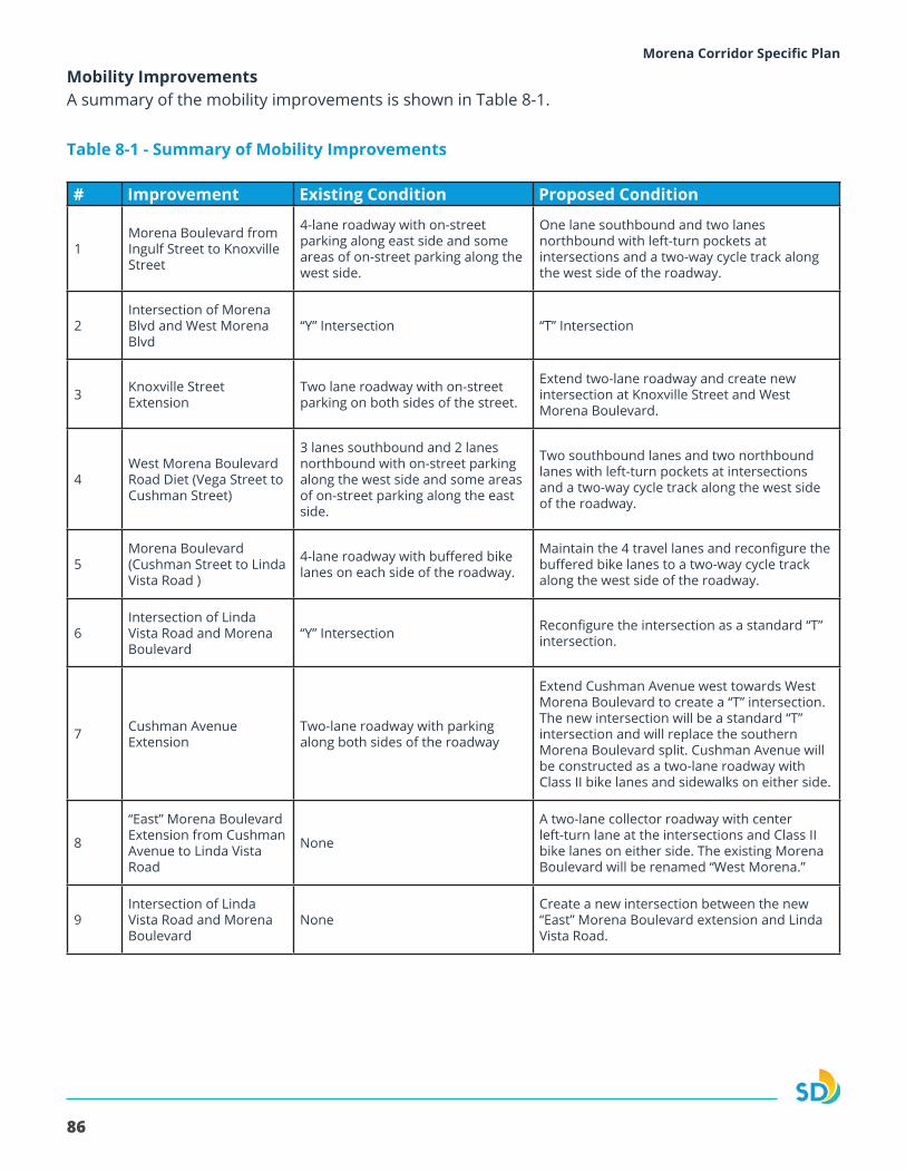
86
Morena Corridor Specific Plan
Mobility ImprovementsA summary of the mobility improvements is shown in Table 8-1.
Table 8-1 - Summary of Mobility Improvements
# Improvement Existing Condition Proposed Condition
1Morena Boulevard from Ingulf Street to Knoxville Street
4-lane roadway with on-street parking along east side and some areas of on-street parking along the west side.
One lane southbound and two lanes northbound with left-turn pockets at intersections and a two-way cycle track along the west side of the roadway.
2Intersection of Morena Blvd and West Morena Blvd
“Y” Intersection “T” Intersection
3 Knoxville Street Extension
Two lane roadway with on-street parking on both sides of the street.
Extend two-lane roadway and create new intersection at Knoxville Street and West Morena Boulevard.
4West Morena Boulevard Road Diet (Vega Street to Cushman Street)
3 lanes southbound and 2 lanes northbound with on-street parking along the west side and some areas of on-street parking along the east side.
Two southbound lanes and two northbound lanes with left-turn pockets at intersections and a two-way cycle track along the west side of the roadway.
5Morena Boulevard (Cushman Street to Linda Vista Road )
4-lane roadway with buffered bike lanes on each side of the roadway.
Maintain the 4 travel lanes and reconfigure the buffered bike lanes to a two-way cycle track along the west side of the roadway.
6Intersection of Linda Vista Road and Morena Boulevard
“Y” Intersection Reconfigure the intersection as a standard “T” intersection.
7 Cushman Avenue Extension
Two-lane roadway with parking along both sides of the roadway
Extend Cushman Avenue west towards West Morena Boulevard to create a “T” intersection. The new intersection will be a standard “T” intersection and will replace the southern Morena Boulevard split. Cushman Avenue will be constructed as a two-lane roadway with Class II bike lanes and sidewalks on either side.
8
“East” Morena Boulevard Extension from Cushman Avenue to Linda Vista Road
None
A two-lane collector roadway with center left-turn lane at the intersections and Class II bike lanes on either side. The existing Morena Boulevard will be renamed “West Morena.”
9Intersection of Linda Vista Road and Morena Boulevard
NoneCreate a new intersection between the new “East” Morena Boulevard extension and Linda Vista Road.
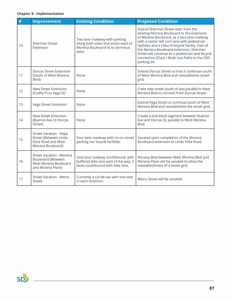
87
Morena Corridor Specific Plan Chapter 8 - Implementation
# Improvement Existing Condition Proposed Condition
10 Sherman Street Extension
Two lane roadway with parking along both sides that exists west of Morena Boulevard to its terminus west.
Extend Sherman Street east, from the existing Morena Boulevard to the extension of Morena Boulevard, as a two-lane roadway wtih a center left turn lane with pedestrian facilities and a Class III bicycle facility. East of the Morena Boulevard extension, Sherman Street will continue as a pedestrian and bicycle connection (Class I Multi Use Path) to the USD parking lot.
11Dorcas Street Extension (South of West Morena Blvd)
NoneExtend Dorcas Street so that it continues south of West Morena Blvd and reestablishes street grid.
12 New Street Extension (Cudhy Pl to Vega St) None Crete new street south of and parallel to West
Morena Blvd to connect from Dorcas Street
13 Vega Street Extension None Extend Vega Street to continue south of West Morena Blvd and reestablishes the street grid.
14New Street Extension (Buenos Ave to Dorcas Street)
NoneCreate a one-block segment between Buenos Ave and Dorcas St, parallel to West Morena Blvd.
15
Street Vacation - Napa Street (Between Linda Vista Road and West Morena Boulevard)
Four lane roadway with no on-street parking nor bicycle facilities.
Vacated upon completion of the Morena Boulevard extension to Linda Vista Road.
16
Street Vacation - Morena Boulevard (Between West Morena Boulevard and Morena Place)
One lane roadway northbound, with buffered bike lane part of the way. 2 lanes southbound with bike lane.
Morena Blvd between West Morena Blvd and Morena Place will be vacated to allow the reestablishment of a street grid.
17 Street Vacation - Metro Street
Currently a cul-de-sac with one lane in each direction. Metro Street will be vacated.