Embed Size (px)
Citation preview
v
© GTA Consultants (GTA Consultants (Vic) Pty Ltd) 2018
The information contained in this document is confidential and
intended solely for the use of the client for the purpose for which it has
been prepared and no representation is made or is to be implied as
being made to any third party. Use or copying of this document in
whole or in part without the written permission of GTA Consultants
constitutes an infringement of copyright. The intellectual property
contained in this document remains the property of GTA Consultants.
Melbourne | Sydney | Brisbane
Canberra | Adelaide | Perth
Gold Coast | Townsville
Moreland Parking Implementation Plan 2019
Issue: A 25/2/19
Client: Moreland City Council
Reference: V132700
GTA Consultants Office: Vic
Quality Record
Issue Date Description Prepared By Checked By Approved By Signed
A 25/2/19 Final – for Council
endorsement Saskia Noakes Chris Coath Chris Coath
V132700 // 25/2/19
Moreland Parking Implementation Plan 2019 // Issue: A
Table of Contents
Executive Summary 1
Introduction 4
Background 4
Purpose 4
Structure 5
Car Parking Implementation Plan Approach 5
Response to Consultation 6
How Parking Delivers the Vision 8
The Role of Parking 8
The Cost of Parking 9
Current Parking Policy Approach 11
Current Transport Policy Overview 11
Parking in the Planning Scheme 11
Moreland Parking Management Policy (2018) 13
Business as usual is not an option 14
Activity Centres in Moreland 15
Accessibility 17
Areas for Focus 18
Delivering the Vision through Parking 21
Directions in MITS 21
Key Parking Topics 22
Managing Parking in Moreland 24
Establishing appropriate parking rates for new development 24
Reallocation of road space and existing car parking 33
Better manage parking resources 34
Statutory Implementation 40
Overview 40
Preparing a Parking Overlay 40
Preparing a Development Contributions Plan 41
V132700 // 25/2/19
Moreland Parking Implementation Plan 2019 // Issue: A
Appendices
A: Existing Parking and Transport Characteristics
B: Parking Rate Approaches
Figures
Figure 1.1: Structure of the Parking Implementation Plan 5
Figure 1.2: Parking Overlay Context 6
Figure 2.1: Cycle of Car Dependency 9
Figure 4.1: Activity Centre Assessment Matrix 17
Figure 6.1: Mode share to walking and cycling, local shopping areas 27
Figure 6.2: Paid Parking Response Spectrums 38
Tables
Table ES.1: Car Parking Provision Approaches 2
Table 2.1: Case Study: Apartment Price, With Vs Without Parking 10
Table 3.1: Mode of transport to work 11
Table 6.1: MITS Mode Share Targets 24
Table 6.2: Car Parking Rate Approaches 25
Table 6.3: Car Ownership Characteristics 28
Table 6.4: Percentage Comparison of Car Demand between Metropolitan Melbourne
and Moreland 30
V132700 // 25/2/19
Moreland Parking Implementation Plan 2019 // Issue: A 1
Executive Summary
The overarching vision for the City of Moreland, as set out in the Moreland Council Plan 2017-
2021, is:
‘Moreland will be known for its proud diversity, and for being a connected, progressive and
sustainable city in which to live, work and play’.
Leading on from this, the transport vision for Moreland Integrated Transport Strategy (MITS) is:
Connecting the City of Moreland through a transport system that is diverse, progressive and
sustainable’,
MITS is a comprehensive transport strategy which addresses five core objectives to achieve the
above overarching vision.
1) A Liveable Moreland
2) A Sustainable Moreland
3) A Moreland that is Safe and Healthy
4) A Moreland that is Accessible and Equitable for all
5) A Prosperous Moreland.
The MITS addresses how to achieve and supplement these objectives from an overarching
transport perspective.
The purpose of the Parking Implementation Plan is to provide further detail on car parking related
actions in the MITS, both to provide strong justification for these changes and to provide further
detail to guide implementation. Importantly, this document provides the detail required to
implement changes to the Moreland Planning Scheme envisaged by MITS.
The MITS Policies and the Parking Policies were developed hand-in-hand to ensure an integrated
and holistic approach to delivering the future of Moreland.
This Parking Implementation Plan sets out a list of polices which are consistent with MITS. In order
to achieve each policy, a list of actions have been developed. The actions identify a number of
ways by which the movement network (vehicular, active transport and public transport) impacts
car parking or is in turn impacted by car parking.
These actions can be simplified, for discussion purposes, to a number of more specific key parking
topics which are discussed within this Parking Implementation Plan. These topics are as follows:
Topic 1: Establishing appropriate parking rates for new development
Topic 2: Reallocation of road space and existing car parking
Topic 3: Effectively managing parking resources.
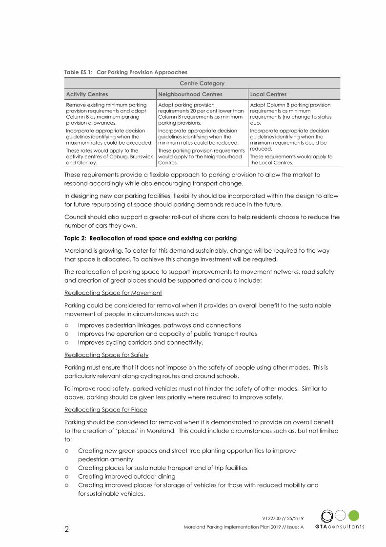
Topic 1: Establishing appropriate parking provision requirements for new development within
Moreland
In the context of Moreland, the adoption of status quo car parking provision requirements is
unlikely to achieve transport change and as such a “vision and validate” approach should be
considered to set maximum parking policies in key areas which would apply to new
developments.
The following car parking provision approaches have been developed to apply across Moreland
Activity Centres:
V132700 // 25/2/19
Moreland Parking Implementation Plan 2019 // Issue: A 2
Table ES.1: Car Parking Provision Approaches
Centre Category
Activity Centres Neighbourhood Centres Local Centres
Remove existing minimum parking
provision requirements and adopt
Column B as maximum parking
provision allowances.
Incorporate appropriate decision
guidelines identifying when the
maximum rates could be exceeded.
These rates would apply to the
activity centres of Coburg, Brunswick
and Glenroy.
Adopt parking provision
requirements 20 per cent lower than
Column B requirements as minimum
parking provisions.
Incorporate appropriate decision
guidelines identifying when the
minimum rates could be reduced.
These parking provision requirements
would apply to the Neighbourhood
Centres.
Adopt Column B parking provision
requirements as minimum
requirements (no change to status
quo.
Incorporate appropriate decision
guidelines identifying when the
minimum requirements could be
reduced.
These requirements would apply to
the Local Centres.
These requirements provide a flexible approach to parking provision to allow the market to
respond accordingly while also encouraging transport change.
In designing new car parking facilities, flexibility should be incorporated within the design to allow
for future repurposing of space should parking demands reduce in the future.
Council should also support a greater roll-out of share cars to help residents choose to reduce the
number of cars they own.
Topic 2: Reallocation of road space and existing car parking
Moreland is growing. To cater for this demand sustainably, change will be required to the way
that space is allocated. To achieve this change investment will be required.
The reallocation of parking space to support improvements to movement networks, road safety
and creation of great places should be supported and could include:
Reallocating Space for Movement
Parking could be considered for removal when it provides an overall benefit to the sustainable
movement of people in circumstances such as:
Improves pedestrian linkages, pathways and connections
Improves the operation and capacity of public transport routes
Improves cycling corridors and connectivity.
Reallocating Space for Safety
Parking must ensure that it does not impose on the safety of people using other modes. This is
particularly relevant along cycling routes and around schools.
To improve road safety, parked vehicles must not hinder the safety of other modes. Similar to
above, parking should be given less priority where required to improve safety.
Reallocating Space for Place
Parking should be considered for removal when it is demonstrated to provide an overall benefit
to the creation of ‘places’ in Moreland. This could include circumstances such as, but not limited
to:
Creating new green spaces and street tree planting opportunities to improve
pedestrian amenity
Creating places for sustainable transport end of trip facilities
Creating improved outdoor dining
Creating improved places for storage of vehicles for those with reduced mobility and
for sustainable vehicles.
V132700 // 25/2/19
Moreland Parking Implementation Plan 2019 // Issue: A 3
Topic 3: Effectively managing parking resources
Council should ensure that all public parking resources in and around activity centres are time-
restricted or provided as permit parking to ensure vehicles are not stored on-street over the long-
term except as permitted by parking permits for existing residents, and to encourage fair use of a
restricted resource.
Consistent with the directions of MITS to charge more fairly for the use of road space to store
private vehicles, Council should review fees for car parking permits to ensure they reflect use of
space and seek to reduce car ownership and use. The allocation and pricing of permits could
also be used to encourage zero emission vehicles.
The pricing of parking is a key demand management tool that can be used to shift the way in
which people travel away from the private car. Council should seek to introduce paid on-street
car parking in appropriate and strategic locations (such as activity centres) to encourage the
turnover of vehicles, more fairly price the use of roads (and parking) and encourage visitors to
use other modes to access their daily needs.
Statutory Implementation
This Parking Implementation Plan discusses a number of the recommendations which would
benefit from being formally included within the Moreland Planning Scheme.
The current Planning Scheme provides a specific mechanism to deal with the parking issues
arising in a precinct and the strategies to be implemented to address them. This mechanism is a
Parking Overlay.
A Parking Overlay is considered to represent the most appropriate tool under the current
Planning Scheme to provide specific guidance to developers regarding the appropriate car
parking requirements and can also consider the provisions for bicycle (including various types
such as cargo bikes), motorbike and scooter parking requirements and the manner in which
future parking should be supplied.
V132700 // 25/2/19
Moreland Parking Implementation Plan 2019 // Issue: A 4
Introduction
Background
Moreland is changing, and the way people travel to and within Moreland will too.
The overarching vision for the City of Moreland, as set out in the Moreland Council Plan 2017-
2021, is:
‘Moreland will be known for its proud diversity, and for being a connected, progressive and
sustainable city in which to live, work and play’.
Leading on from this, the transport vision for Moreland Integrated Transport Strategy 2019 (MITS) is:
Connecting the City of Moreland through a transport system that is diverse, progressive and
sustainable’,
The MITS is a comprehensive transport strategy which addresses five core objectives to achieve
the above overarching vision.
1) A Liveable Moreland
2) A Sustainable Moreland
3) A Moreland that is Safe and Healthy
4) A Moreland that is Accessible and Equitable for all
5) A Prosperous Moreland.
The MITS addresses how to achieve and supplement these objectives from an overarching
transport perspective.
Ultimately, change is needed to the way travel is thought about in Moreland.
Living in Moreland
Moreland is growing, its population is getting younger, townhouses and apartments are
becoming more popular, and the nature of work is changing. The way parking is approached
needs to respond and adapt to meet the needs of these changes in order to retain the liveability
of Moreland and manage transport issues associated with a denser population.
The Challenge
The challenge for Moreland will be to plan and advocate for parking measures that are not only
needed now, but also cater to the needs of tomorrow, in terms of promoting liveability, equity,
economic and sustainability.
The future of Moreland needs to be driven by an understanding of the true cost of parking and its
role in influencing the urban form, transport patterns and investment in Moreland.
Purpose
The purpose of the Parking Implementation Plan is to provide further detail on car parking related
actions in the MITS, both to provide strong justification for these changes and to provide further
detail to guide implementation. Importantly, this document provides the detail required to
implement changes to the Moreland Planning Scheme envisaged by MITS.
The MITS Policies and the Parking Policies were developed hand-in-hand to ensure an integrated
and holistic approach to delivering the future transport needs of Moreland.
1
V132700 // 25/2/19
Moreland Parking Implementation Plan 2019 // Issue: A 5
Parking plays an instrumental role in supporting broader transport strategies within MITS. Parking
policies can have both a direct and indirect impact on the ability to achieve objectives related
to such strategies. The supply of parking at trip origins and destinations is a strong driver of mode
choice.
Parking Policy is a key lever over which Council has significant control which can influence the
mode shift towards walking, cycling and public transport. Therefore, parking is an opportunity for
Council to encourage sustainable modes of transport. This is particularly important as a tool for
Council to encourage the use of public transport given Council is ultimately not in control of
these services.
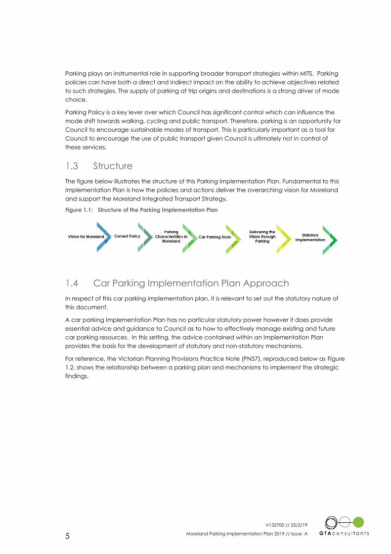
Structure
The figure below illustrates the structure of this Parking Implementation Plan. Fundamental to this
Implementation Plan is how the policies and actions deliver the overarching vision for Moreland
and support the Moreland Integrated Transport Strategy.
Figure 1.1: Structure of the Parking Implementation Plan
Car Parking Implementation Plan Approach
In respect of this car parking implementation plan, it is relevant to set out the statutory nature of
this document.
A car parking Implementation Plan has no particular statutory power however it does provide
essential advice and guidance to Council as to how to effectively manage existing and future
car parking resources. In this setting, the advice contained within an Implementation Plan
provides the basis for the development of statutory and non-statutory mechanisms.
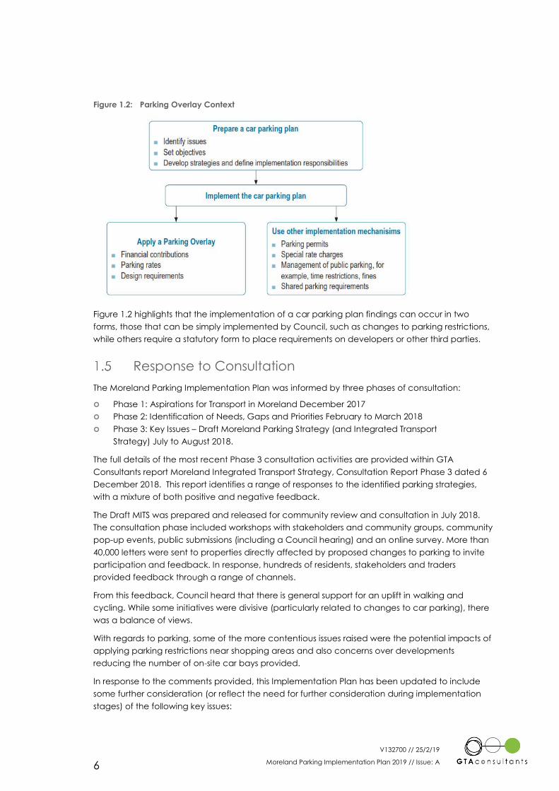
For reference, the Victorian Planning Provisions Practice Note (PN57), reproduced below as Figure
1.2, shows the relationship between a parking plan and mechanisms to implement the strategic
findings.
V132700 // 25/2/19
Moreland Parking Implementation Plan 2019 // Issue: A 6
Figure 1.2: Parking Overlay Context
Figure 1.2 highlights that the implementation of a car parking plan findings can occur in two
forms, those that can be simply implemented by Council, such as changes to parking restrictions,
while others require a statutory form to place requirements on developers or other third parties.
Response to Consultation
The Moreland Parking Implementation Plan was informed by three phases of consultation:
Phase 1: Aspirations for Transport in Moreland December 2017
Phase 2: Identification of Needs, Gaps and Priorities February to March 2018
Phase 3: Key Issues – Draft Moreland Parking Strategy (and Integrated Transport
Strategy) July to August 2018.
The full details of the most recent Phase 3 consultation activities are provided within GTA
Consultants report Moreland Integrated Transport Strategy, Consultation Report Phase 3 dated 6
December 2018. This report identifies a range of responses to the identified parking strategies,
with a mixture of both positive and negative feedback.
The Draft MITS was prepared and released for community review and consultation in July 2018.
The consultation phase included workshops with stakeholders and community groups, community
pop-up events, public submissions (including a Council hearing) and an online survey. More than
40,000 letters were sent to properties directly affected by proposed changes to parking to invite
participation and feedback. In response, hundreds of residents, stakeholders and traders
provided feedback through a range of channels.
From this feedback, Council heard that there is general support for an uplift in walking and
cycling. While some initiatives were divisive (particularly related to changes to car parking), there
was a balance of views.
With regards to parking, some of the more contentious issues raised were the potential impacts of
applying parking restrictions near shopping areas and also concerns over developments
reducing the number of on-site car bays provided.
In response to the comments provided, this Implementation Plan has been updated to include
some further consideration (or reflect the need for further consideration during implementation
stages) of the following key issues:
V132700 // 25/2/19
Moreland Parking Implementation Plan 2019 // Issue: A 7
Provided clarification of the role and definition of Parking Minimum and Parking
Maximum requirements.
Provided additional detail of parking time restriction amendments and how these can
benefit the allocation of parking to key user groups.
Provided additional consideration of social equity issues related to the pricing of
parking permits to ensure fair access is available to all.
Included the potential for consideration of the additional permit types and the
expansion of some existing permits to off-set the extension of parking time restrictions.
Included the possibility of setting a daily fee for paid parking to allow paid parking to
remain accessible to long stay users to off-set the extension of parking time restrictions.
V132700 // 25/2/19
Moreland Parking Implementation Plan 2019 // Issue: A 8
How Parking Delivers the Vision
This Parking Implementation Plan has been developed to consider not only the current parking
system but what the future of parking could look like and how this will contribute to achieving the
vision for Moreland. It is critical that a forward-thinking approach is taken to reduce the need for
‘retrofitting’ solutions in the future.
Parking is a policy lever which can be used to implement the broader transport objectives and
unlock the vision for Moreland.
Further to this, the following realities relating to urban space have been considered in the
development of the policies and associated actions:
Road space is a finite resource
We need to cater for people’s needs.
The work across both strategies has been informed by:
Community feedback - The community had a clear voice that liveability, sustainability
and safety should be the top three objectives driving transport direction and outcomes
in MITS 2018.
Current Moreland strategies – The transport vision is informed by Moreland’s broader
strategic direction and existing policies, as discussed in detail within MITS.
Local and international best practice – Through the team’s experience, research and
expert knowledge, the best ideas from around Australia and the world have been
tailored to realise the Transport Vision for Moreland.
The Role of Parking
As discussed above, parking plays an instrumental
role in supporting broader transport and land use
strategies. Parking policies can have both a direct
and indirect impact on the ability to achieve
objectives related to such strategies. The supply of
parking at trip origins and destinations is a strong
driver of mode choice. This Implementation Plan
recognises that sometimes parking is required in
cases where people have special needs. For
example, to provide access for young families or
people with mobility impairment to access the
community. Therefore, parking should be prioritised
for people who truly need it. In doing so, it is still
possible to discourage car use and contribute to a shift towards sustainable transport modes
while catering to people who most need to drive.
Studies have shown that parking incentivises people to drive more, contributing to congestion. In
fact, much of our current parking policy was developed to encourage car use1. When, as a
response to this congestion, more road space (and parking) is provided, this can result in what is
known as a ‘cycle of car dependency’, which can compromise liveability and pose unnecessary
1 Taylor (2016) The elephant in the scheme: Planning for and around car parking in Melbourne, 1929–2016, Centre for Urban
Research, RMIT University, Australia.
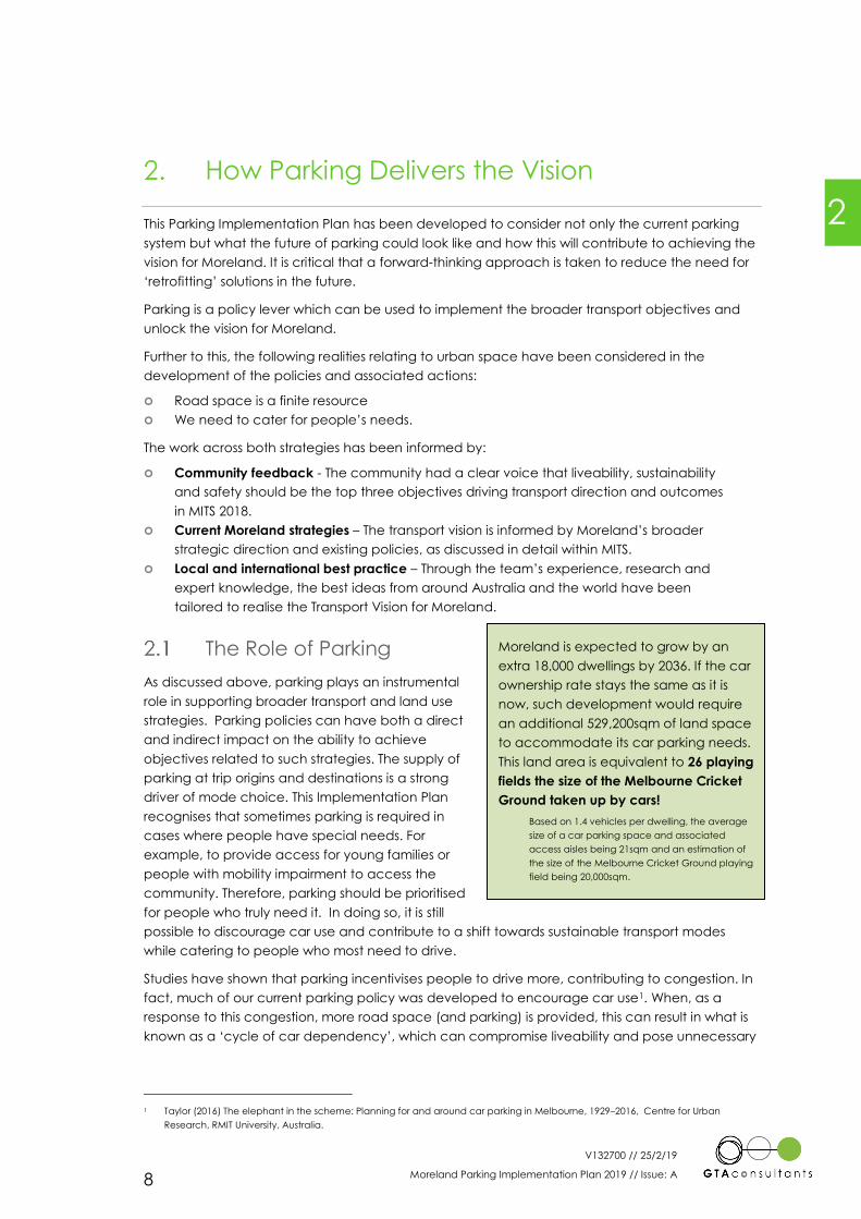
Moreland is expected to grow by an
extra 18,000 dwellings by 2036. If the car
ownership rate stays the same as it is
now, such development would require
an additional 529,200sqm of land space
to accommodate its car parking needs.
This land area is equivalent to 26 playing
fields the size of the Melbourne Cricket
Ground taken up by cars!
Based on 1.4 vehicles per dwelling, the average
size of a car parking space and associated
access aisles being 21sqm and an estimation of
the size of the Melbourne Cricket Ground playing
field being 20,000sqm.
2
V132700 // 25/2/19
Moreland Parking Implementation Plan 2019 // Issue: A 9
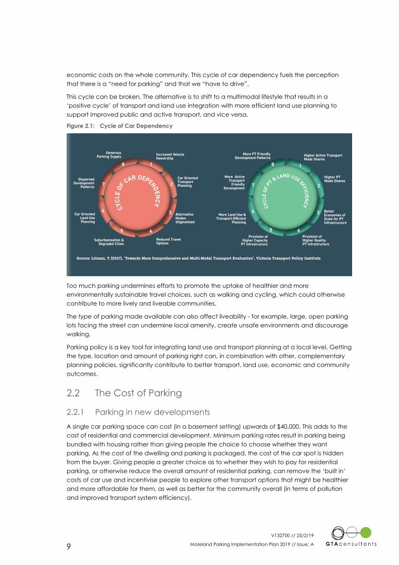
economic costs on the whole community. This cycle of car dependency fuels the perception
that there is a “need for parking” and that we “have to drive”.
This cycle can be broken. The alternative is to shift to a multimodal lifestyle that results in a
‘positive cycle’ of transport and land use integration with more efficient land use planning to
support improved public and active transport, and vice versa.
Figure 2.1: Cycle of Car Dependency
Too much parking undermines efforts to promote the uptake of healthier and more
environmentally sustainable travel choices, such as walking and cycling, which could otherwise
contribute to more lively and liveable communities.
The type of parking made available can also affect liveability - for example, large, open parking
lots facing the street can undermine local amenity, create unsafe environments and discourage
walking.
Parking policy is a key tool for integrating land use and transport planning at a local level. Getting
the type, location and amount of parking right can, in combination with other, complementary
planning policies, significantly contribute to better transport, land use, economic and community
outcomes.
The Cost of Parking
2.2.1 Parking in new developments
A single car parking space can cost (in a basement setting) upwards of $40,000. This adds to the
cost of residential and commercial development. Minimum parking rates result in parking being
bundled with housing rather than giving people the choice to choose whether they want
parking. As the cost of the dwelling and parking is packaged, the cost of the car spot is hidden
from the buyer. Giving people a greater choice as to whether they wish to pay for residential
parking, or otherwise reduce the overall amount of residential parking, can remove the ‘built in’
costs of car use and incentivise people to explore other transport options that might be healthier
and more affordable for them, as well as better for the community overall (in terms of pollution
and improved transport system efficiency).
V132700 // 25/2/19
Moreland Parking Implementation Plan 2019 // Issue: A 10
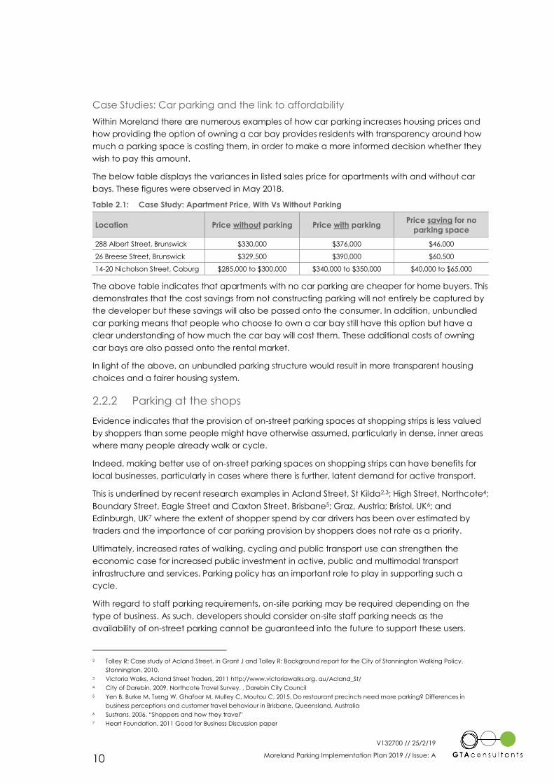
Case Studies: Car parking and the link to affordability
Within Moreland there are numerous examples of how car parking increases housing prices and
how providing the option of owning a car bay provides residents with transparency around how
much a parking space is costing them, in order to make a more informed decision whether they
wish to pay this amount.
The below table displays the variances in listed sales price for apartments with and without car
bays. These figures were observed in May 2018.
Table 2.1: Case Study: Apartment Price, With Vs Without Parking
Location Price without parking Price with parking Price saving for no
parking space
288 Albert Street, Brunswick $330,000 $376,000 $46,000
26 Breese Street, Brunswick $329,500 $390,000 $60,500
14-20 Nicholson Street, Coburg $285,000 to $300,000 $340,000 to $350,000 $40,000 to $65,000
The above table indicates that apartments with no car parking are cheaper for home buyers. This
demonstrates that the cost savings from not constructing parking will not entirely be captured by
the developer but these savings will also be passed onto the consumer. In addition, unbundled
car parking means that people who choose to own a car bay still have this option but have a
clear understanding of how much the car bay will cost them. These additional costs of owning
car bays are also passed onto the rental market.
In light of the above, an unbundled parking structure would result in more transparent housing
choices and a fairer housing system.
2.2.2 Parking at the shops
Evidence indicates that the provision of on-street parking spaces at shopping strips is less valued
by shoppers than some people might have otherwise assumed, particularly in dense, inner areas
where many people already walk or cycle.
Indeed, making better use of on-street parking spaces on shopping strips can have benefits for
local businesses, particularly in cases where there is further, latent demand for active transport.
This is underlined by recent research examples in Acland Street, St Kilda2,3; High Street, Northcote4;
Boundary Street, Eagle Street and Caxton Street, Brisbane5; Graz, Austria; Bristol, UK6; and
Edinburgh, UK7 where the extent of shopper spend by car drivers has been over estimated by
traders and the importance of car parking provision by shoppers does not rate as a priority.
Ultimately, increased rates of walking, cycling and public transport use can strengthen the
economic case for increased public investment in active, public and multimodal transport
infrastructure and services. Parking policy has an important role to play in supporting such a
cycle.
With regard to staff parking requirements, on-site parking may be required depending on the
type of business. As such, developers should consider on-site staff parking needs as the
availability of on-street parking cannot be guaranteed into the future to support these users.
2 Tolley R: Case study of Acland Street, in Grant J and Tolley R: Background report for the City of Stonnington Walking Policy.
Stonnington, 2010.
3 Victoria Walks, Acland Street Traders, 2011 http://www.victoriawalks.org. au/Acland_St/
4 City of Darebin, 2009, Northcote Travel Survey. , Darebin City Council
5 Yen B, Burke M, Tseng W, Ghafoor M, Mulley C, Moutou C, 2015, Do restaurant precincts need more parking? Differences in
business perceptions and customer travel behaviour in Brisbane, Queensland, Australia
6 Sustrans, 2006, “Shoppers and how they travel”
7 Heart Foundation, 2011 Good for Business Discussion paper
V132700 // 25/2/19
Moreland Parking Implementation Plan 2019 // Issue: A 11
Current Parking Policy Approach
This Chapter presents a summary of where this Parking Implementation Plan fits in within the
overarching policy context and why a ‘business as usual’ approach is not sustainable.
Current Transport Policy Overview
Current policy (local and state) is to reduce the reliance on private car travel and encouraging
walk, cycle and public transport trips.
Moreland’s Municipal Strategic Statement (MSS) states:
[The] Strategic Framework of the MSS is predicated on developing sustainable neighbourhoods
by integrating transport and land use planning decision making which maximise people’s
opportunities to walk, cycle and use public transport.
As it relates to car parking, the current policies promote other modes of travel but also seek to
provide car parking. Over the past four years, Moreland’s household survey shows that this policy
has not seen a significant mode shift away from the car.
Table 3.1: Mode of transport to work
Base: Currently
Employed
2013
(n=1190)
2015
(n=1070)
2017
(n=1029)
Car (as driver) 63.6% 66% 63%
Current Council policies, while supporting the multimodal nature of activity-centres in Moreland,
do not specifically push further to encourage or force mode shift. Previous strategies for Coburg
and Brunswick have supported this multimodal approach to planning. However, the lack of
formal planning scheme incorporation, means that decisive planning guidance is not available
to all involved in the planning decision-making process (i.e. developer, council officers,
Councillors, third party submitters and further VCAT and the Planning Minister).
On the basis of the above, it is clear that Moreland has aspirational policies towards supporting
sustainable transport modes. Yet local policies in the planning scheme could be more direct in
pushing for a mode shift towards sustainable transport.
As such, parking policy is critical lever which must clearly work towards a demonstrable change in
mode shift towards sustainable transport.
Parking in the Planning Scheme
3.2.1 Definitions
Minimum Parking Provision Requirements
A minimum parking provision requirement represents the minimum amount of parking a new
development is required to provide to support the size of development (number of dwellings,
floor space etc.). A developer may provide a greater amount of parking if desired. A planning
permit can however typically be sought for a lesser amount of parking.
3

V132700 // 25/2/19
Moreland Parking Implementation Plan 2019 // Issue: A 12
Maximum Parking Provision Policies
A maximum parking provision requirement represents a policy which restricts the amount of
parking that is allowed to be provided by a development. A developer can choose to provide
any amount of parking between the maximum requirement and zero (unless an alternate
minimum requirement is set). A planning permit can be sought for a greater amount of parking
than the maximum limit.
3.2.2 Clause 52.06
Clause 52.06 of the Victorian Planning Provisions sets out minimum parking provision requirements
for new and altered developments (where an increase in development scale occurs). The
default requirements are called “Column A”. These requirements are also supplemented by a set
of decision guidelines which facilitate the consideration of reductions to these minimum
provisions. These rates are the default rates that apply across Victoria, unless varied by Council
by way of a Parking Overlay8. A number of recent changes have occurred to Clause 52.06,
specifically Column B rates now apply to not just land subject to a Parking Overlay where the
Column B rates have been specified, but also all land identified as being within 400m of the
Principal Public Transport Network Area. Therefore, lower car parking rates will now automatically
apply to many activity centres.
Clause 52.06 also sets out parking provision requirements known as “Column B”. Column B
parking provisions outline a lesser requirement than the standard requirements shown in Column
A.
The Column B requirements could be considered to typically reflect an ‘Activity Centre’ setting,
which begin to account for the sharing of car parking between multiple uses during the peak
(weekday, midday) time of the activity centre. An example of the difference between Column A
and Column B requirements are that a residential development (such as the construction of a set
of apartments) must provide a space for visitors to park in for every 5 dwellings under Column A.
This is not required under Column B. This difference is not intended to highlight under Column B
that residential visitor parking is not generated, rather at the peak time of activity centre (likely to
be middle of the day) demands for residential visitor parking are likely to be low.
Column B requirements are required to be activated through the use of a Parking Overlay at
Clause 45.09 of the Planning Scheme. The car parking requirements for both Column A and B are
listed within the state-wide Clauses of the Victorian Planning Provisions.
There are many Activity Centres throughout Melbourne (including Moreland) that have these
requirements applied to them. This includes Hawthorn, Kew, Footscray and Heidelberg.
While Column B requirements are more appropriate to be applied to activity centres, they are
not tailored to the individual transport availability and land use characteristics of each specific
Activity Centre.
3.2.3 Clause 22.03
Clause 22.03 of the Moreland Planning Scheme supplements Clause 52.06 Car Parking and
Clause 52.34 Bicycle Facilities supporting Council’s commitment to “developing sustainable
neighbourhoods by improving the quality and design of the built environment, and integrating
transport and land use planning to optimise people’s opportunity to walk, cycle and use public
transport.”
8 Alternate car parking provision requirements are sometimes prescribed in other Planning Scheme Clauses (such as within a
Schedule to a Development Plan Overlay or similar).
V132700 // 25/2/19
Moreland Parking Implementation Plan 2019 // Issue: A 13
As it relates to car parking the policy provides support to (but limited to):
Reduced car parking provision requirements in developments within and in close
proximity to activity centres, with excellent access to a range of public transport options
and with increased provision of bicycle parking above the requirements specified in
Clause 52.34.
Encourages shared car parking arrangements where appropriate.
Ensuring land uses frequented by people with limited mobility, such as hospitals and
medical centres, provide sufficient car parking spaces, including an appropriate
proportion of disabled car spaces.
Ensuring car parking and site access does not dominate urban design or compromise
pedestrian safety and priority.
3.2.4 Clause 45.09
Clause 45.09 of the Moreland Planning Scheme applies a Parking Overlay to land uses in the
Mixed-Use Zone, Residential Growth Zone, Commercial 1 Zone, Commercial 2 Zone and Activity
Centre Zone within the City of Moreland. This overlay applies the Column B parking provision
requirements outlined in Clause 52.06 of the Moreland Planning Scheme.
Column B parking requirements outline a lesser requirement than the standard requirements
shown in Column A.
As noted above, while these Column B requirements are more appropriate to be applied to
activity centres, they are not tailored to the individual transport availability and land use
characteristics of each specific Activity Centre.
As such there are still many circumstances in which the provision requirements advised under the
planning scheme are not applied. Each development is assessed individually, and if it is deemed
appropriate to apply a lesser requirement, then Council or VCAT will approve them. Some
developments are being approved throughout Moreland with close to no parking provided on
site, if it is deemed to be appropriate and acceptable outcome.
This is evidenced by way of example: a review of 8 significant development planning
applications lodged and approved by Council in 2017 indicated that on average a 19 per cent
reduction (from the Parking Overlay requirements) to parking was sought for the residential
components of the development and on average a 10 per cent reduction was sought for the
commercial component of the development.
In a diverse municipality such as Moreland, with accessibility levels varying across activity centres,
more specific consideration of the applied car parking provision requirements is required,
particularly if these are to inform and achieve the mode shift aims of the Moreland Integrated
Transport Strategy.
Clause 45.09 can also remove minimum parking requirements and introduce parking maximum
policies where required. Currently such maximum policies are not in place in Moreland.
The use of parking maximums may need to be complemented by additional on-street parking
restrictions. This is however dealt with through a different mechanism such as the Moreland
Parking Management Policy.
Moreland Parking Management Policy (2018)
The Moreland Parking Management Policy (2018) provides a framework for the management of
Council owned parking (on-street and off-street) in Moreland. It was originally developed in 2011
and was revised in 2018 with only minor changes.
V132700 // 25/2/19
Moreland Parking Implementation Plan 2019 // Issue: A 14
It includes:
Setting of parking time limits and restrictions
Issuing of residential permits provides residents of properties prior to 2011 with an
advantage in accessing parking due to exemption from local restrictions.
Criteria for the establishment of paid parking. It is noted that the current criteria for the
introduction of paid parking is quite difficult to achieve and may warrant review.
In addition, the Moreland Parking Management Policy includes a car share policy.
The car share policy aims to achieve the following objectives:
Use parking more efficiently.
Reduce emissions.
Support the local economy.
Encourage more sustainable travel options.
Improve access and social inclusion.
The Parking Management Policy is a critical tool which supplements the setting of car parking
rates (in a Parking Overlay) to manage on-street parking and restrictions, in particular where
parking minimums are removed.
Business as usual is not an option
Current policies begin to reflect the activity centre nature of centres within Moreland. However,
they do not push far enough to truly encourage or force mode shift. Car parking disincentives as
well as sustainable transport incentives are required to break the negative cycle of car
dependency.
Previous strategies for Coburg and Brunswick have also supported a shift towards active travel
and have suggested lowering parking provision requirements including introducing ‘maximum’
policies. However, the lack of formal planning scheme incorporation, mean that decisive
planning guidance is not available to all involved in the planning decision making process
(developer, council officers, Councillors, third party submitters and further VCAT and the Planning
Minister).
Given both the Coburg Activity Centre and Brunswick Activity Centre are both well-established
areas, parking restrictions and allocations were implemented many years ago, to assist with the
turnover and allocation of parking spaces in high activity areas. Many of these restrictions have
not changed or been reviewed over the years. As is the case in Moreland and many other
municipalities, parking restrictions are only reviewed reactively based on community feedback or
complaint. Finally, there is very little paid parking implemented in these activity centres.
The Parking Implementation Plan, which encompasses the whole municipality, will work hand in
hand with the Moreland Integrated Transport Strategy to drive real change to the way in which
parking and transport infrastructure is delivered in the future.
Both MITS and the Parking Implementation Plan recognises that Moreland is diverse and not all
suburbs contain the same types of activity or level of accessibility. The parking policies are aimed
at addressing the issues identified in the current active areas of Moreland (e.g. Coburg and
Brunswick). Applying these same policies to areas that are currently less active but are still
experiencing growth (e.g. Coburg) is an opportunity to future proof against issues associated with
the anticipated growth.
V132700 // 25/2/19
Moreland Parking Implementation Plan 2019 // Issue: A 15
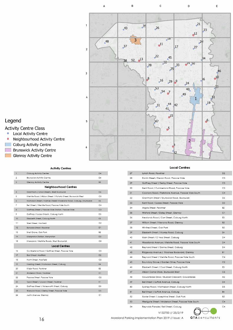
Activity Centres in Moreland
This Chapter provides a high-level review of the existing parking and transport characteristics in
Moreland.
Moreland is made up of a number activity centres, being grouped into three primary categories:
Activity Centres; Neighbourhood Centres; and Local Centres.9 These centres are shown
graphically and listed in the following page. In addition, it is noted that there are areas within
Moreland that currently have a Parking Overlay (due to zoning) and although they are not Local
Centres they are proposed to be treated the same with Column B minimum rates applied.
9 Reference: Moreland Planning Scheme, Clause 21.02
4
V132700 // 25/2/19
Moreland Parking Implementation Plan 2019 // Issue: A 16
A B C D E
1
2
3
4
5
6
V132700 // 25/2/19
Moreland Parking Implementation Plan 2019 // Issue: A 17
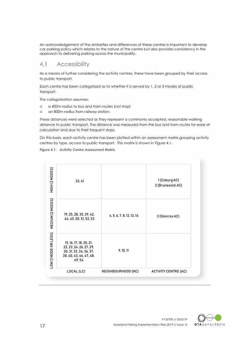
An acknowledgement of the similarities and differences of these centres is important to develop
car parking policy which relates to the nature of the centre but also provides consistency in the
approach to delivering parking across the municipality.
Accessibility
As a means of further considering the activity centres, these have been grouped by their access
to public transport.
Each centre has been categorised as to whether it is served by 1, 2 or 3 modes of public
transport.
The categorisation assumes:
a 400m radius to bus and tram routes (not stop)
an 800m radius from railway station.
These distances were selected as they represent a commonly accepted, reasonable walking
distance to public transport. The distance was measured from the bus and tram routes for ease of
calculation and due to their frequent stops.
On this basis, each activity centre has been plotted within an assessment matrix grouping activity
centres by type, access to public transport. This matrix is shown in Figure 4.1.
Figure 4.1: Activity Centre Assessment Matrix
LO
W (
1 M
OD
E O
R L
ES
S)
LOCAL (LC) NEIGHBOURHOOD (NC) ACTIVITY CENTRE (AC)
ME
DIU
M (
2 M
OD
ES
) H
IGH
(3
MO
DE
S)
1 (Coburg AC)
2 (Brunswick AC)
3 (Glenroy AC) 4, 5, 6, 7, 8, 12, 13, 14
33, 41
19, 25, 28, 35, 39, 42, 44, 45, 50, 51, 52, 53
15, 16, 17, 18, 20, 21, 22, 23, 24, 26, 27, 29, 30, 31, 32, 34, 36, 37,
38, 40, 43, 46, 47, 48, 49, 54
9, 10, 11
V132700 // 25/2/19
Moreland Parking Implementation Plan 2019 // Issue: A 18
Activity centres with access to 3 modes of public transport are all located within the southern half
of the municipality. A majority of centres within the southern half of the municipality (south of Bell
Street) are all served by at least 2 modes of public transport. Within the northern half of the
municipality a large portion of activity centres are served by only one mode of public transport
(bus) except for those located specifically along heavy rail lines.
In general, the Activity Centre, Neighbourhood Centre and Local Centre categories correlate
with access to public transport.
Activity Centres – 2 of 3 centres have access to 3 modes of public transport
Neighbourhood Centres – Most centres have access to 2 modes of public transport
Local Centres – Most centres have access to 1 mode of transport.
Areas for Focus
From the above there are clear patterns that confirm that the current Activity Centre
classifications align with centre accessibility. The following further observations of each activity
centre category can be made:
Activity Centres: These centres represent those which have a broad land use mix allowing for
sharing of parking between uses and are supported by public transport facilities.
These centres will experience the highest level of change and growth in coming years. This
nature of change makes these centres the primary focus to achieve mode shift within the
municipality. The nature of public transport access allows these centres the best opportunity to
tolerate mode shift.
If significant mode shift is to be achieved within the municipality, proactive parking approaches
must be adopted (to control parking overspill, manage demand for parking and reallocate
space used for parking other uses as appropriate) within these centres where change can be
more easily tolerated.
Neighbourhood Centres: These centres will experience some land use change, growth and
densification. Public transport facilities are available to support mode shift opportunities.
As such parking policy needs to be used as a tool to encourage people to reduce the number of
car trips as population grows and increase the attractiveness of sustainable transport modes.
Local Centres: These centres will either not experience change or have poor access to public
transport alternatives.
The limited change will therefore mean that new developments in these centres will contribute
least to overall municipality mode shift. Further mode shift can be less tolerated due to the lesser
access alternatives. The resultant outcome will be that a more conservative parking
management approach is likely to be relevant to these areas.
Activity Centres and Neighbourhood Centres will therefore provide a focus for the further
consideration in the following sections of this report of existing parking and transport
characteristics across the municipality.
A review of the key areas within each category has been outlined below with further detail also
included in Appendix A. This tells the story of how Moreland currently functions from a parking
perspective.
V132700 // 25/2/19
Moreland Parking Implementation Plan 2019 // Issue: A 19
4.2.1 Activity Centres
For the purpose of describing existing parking and transport conditions, Activity Centres have
been divided up as follows:
Sydney Road (Coburg AC and part of the Brunswick AC)
Brunswick East (part of the Brunswick AC), and
Glenroy AC.
Sydney Road
One of the most important characteristics of parking and transport along Sydney Road is the
nature of specialty retail and the long ‘strip shop’ layout of the activity centres. As the shopping
precinct is so long, considering Sydney Road as one activity centre does not cater as well for to
multi-purpose trips as a more condensed centre. This is owing to inaccessibility by efficient means
of public transport or where the visit may require the handling of bulky or delicate goods.
The allocation of kerbside parking is consistent along the length of Sydney Road which provides
short term (either 1 or 2-hour timed restrictions) parking for casual users to increase vehicle
turnover. Additionally, other special use zones have been implemented over time including
parking for people with disabilities, loading zones and drop off-pick up areas (less than 15
minutes). Parking is generally highly utilised along the strip, dependant on time and location
based on the type of businesses (e.g. office, specialty retail, entertainment, dining) located in
each precinct.
Both public and private at-grade off street car parks are located at various locations to the rear of
buildings along Sydney Road, accessible from adjoining streets. Council managed carparks have
medium term parking restrictions (generally 2 or 3-hour) to promote longer multi-purpose trips to
businesses within the activity centres, while discouraging employee and commuter car parking.
While on-street paid parking is essentially non-existent within the municipality (with the exception
of Barkly Street near Barkly Square), there are seven fee paying Council carparks at the south end
of Sydney Road. The occupancy of these car parks is typically low due to the availability of free
parking in the area. There are also several private paid carparks, some of which have a period of
free parking for casual users, to discourage all day parking. As such, all seven carparks are
located at the southern end of Sydney Road.
Clearways have been implemented on Sydney Road to assist traffic flows during peak periods
and facilitate efficient movements of trams.
Sydney Road is well connected to public transport. However, the availability of free parking and
ease of access to car parking encourages driving and discourages the use of these sustainable
options.
Brunswick East
Both Nicholson Street and Lygon Street have almost no off-street public parking, and as such,
parking in adjoining residential streets is much more congested than is seen in Sydney Road. Paid
parking is not present in either street. However short-term parking restrictions apply on street, with
in-ground sensors, to increase compliance and turnover of parking spaces.
Clearways have been implemented on Lygon Street to assist traffic flows during peak periods
and facilitate efficient movements of trams.
Most residential streets have had some residential parking restrictions applied, and parking in the
short-term areas experience high demand as do the unrestricted areas. This is largely due to the
high occupancy of on-street resources on the main roads and people seeking to find alternative
parking near their destination.
V132700 // 25/2/19
Moreland Parking Implementation Plan 2019 // Issue: A 20
On-site observations indicate that occupancy of short term parking on-street varies in both
Nicholson and Lygon Street with generally some availability of parking within the area, suggesting
that many people travel to the activity centre by public transport or active travel modes. This
suggests that the space currently used for parking could be better served in other ways such as
creating place or serving active transport modes.
Glenroy AC
The ease of access by car into the centre from short distances along with the availability of
secure and free off-street parking are major factors in determining the characteristics of parking
in this centre.
On street parking is not permitted on parts of Pascoe Vale Road. Parking in Glenroy AC is served
by several large at-grade off-street carparks. Some on-street parking is available on Wheatsheaf
Road and along adjoining streets to Pascoe Vale Road.
Parking restrictions vary across the centre, with a mix of both short and long-term restrictions
supplying different user groups depending on the adjacent land use.
A large off-street carpark for rail commuters is provided at the train station with additional
unrestricted carparking provided for in the car park called ‘Dowd Place’.
Another characteristic of the activity centre is that a lot of employee parking is catered for at-
grade within the property, or in one of the business permit zones.
While the activity centre is located around a train station, the ease of access by car and amount
of parking available encourages short car trips.
4.2.2 Neighbourhood Centres
Neighbourhood Centres are much smaller and generally located away from arterial roads,
making them even more susceptible to short vehicle trips. Notwithstanding surveys conducted by
Council (refer Figure 6.1 later) indicate many trips to Neighbourhood centres are made by
walking and cycling modes. Given the spacing and location of most neighbourhood and local
centres within the municipality, it could be expected that some if not most of the vehicle trips into
the activity centres could be supplemented by other modes of transport. Further to this, the
parking characteristics within Neighbourhood Centres generally have short term parking
restrictions to encourage high turnover. It has also been noted that a number of locations within
this category (e.g. Union Street / Grantham Street) contain commuter parking which often results
in spill over into the surrounding residential streets during peak times. Further discussion on each of
these centres is provided in Appendix A.

V132700 // 25/2/19
Moreland Parking Implementation Plan 2019 // Issue: A 21
Delivering the Vision through Parking
Directions in MITS
The Moreland Integrated Transport Strategy identifies core objectives and along with it a range of
policies and actions across the transport spectrum. These objectives and associated policies and
actions as they relate to car parking are reproduced below.
Further discussion on the tools required to support these actions is detailed in the subsequent
sections of this report.
MITS sets out that the vision for the future of transport in Moreland is built upon five key
foundations or objectives. These are detailed below with their relevant policies and actions.
A liveable Moreland
‘Where the transport network is family-friendly, where we consciously reduce local vehicle traffic
and safeguard the wellbeing of our community.’ (MITS)
MITS recognises that good cities are ones that are better at promoting the best interests of their
communities, in terms not just of prosperity but also of liveability – how cities and the people that
live in them combine and contribute to a sense of wellbeing within the community. Parking has
an important role to play in fostering such liveability.
Car parks rarely if at all contribute to public amenity and a sense of security and well-being – in
fact, they can do the opposite when not integrated with surrounding land uses that offer
interaction and surveillance.
Further to this, parking takes up space that could alternatively be used for either ‘moving people’
‘or creating a place for people’. Council and the community need to re-evaluate when and
where parking is needed to support a liveable Moreland into the future.
A sustainable Moreland
‘Which achieves a city-leading shift toward sustainable modes of travel, supporting the transition
to active or zero emissions transport by 2040’ (MITS)
The existing car parking policies in Moreland encourage the use of the car for most trips in
Moreland. This is demonstrated by existing minimum parking rates for new developments and free
parking in most destinations within Moreland, reinforcing a culture of using the car even for short
trips that could be walked. This culture results in congestion – which during Community
Consultation many people expressed they do not want in Moreland.
Addressing an oversupply of car parking creates a self-reinforcing ‘positive cycle’ and in turn
helps deliver a more sustainable Moreland.
A Moreland that is safe and healthy
‘Where transport safety is a key focus, we improve personal security and safety and promote a
healthy community with cleaner air.’ (MITS)
It is understood from community feedback that it is currently common for cars to be parked in
ways that jeopardise the safety of the community, for example along footpaths or near school
entrances. Parking must ensure that it does not impose on the safety of people using other
modes.
5
V132700 // 25/2/19
Moreland Parking Implementation Plan 2019 // Issue: A 22
A Moreland that is accessible and equitable for all
‘Where we reduce barriers to community movement and strongly commit to making Moreland
accessible to all’ (MITS)
Accessibility is about making sure everyone feels they have a place in Moreland.
Some people have a high need to drive, for example young families and disabled people
sometimes must drive in order to access opportunities, including shopping and services. In the
future, alternative technologies may reduce this need (for example autonomous vehicles).
However, until future technologies are able to provide an alternative for these people to drive,
parking should be prioritised for these users.
Providing an accessible and equitable Moreland means being honest about who actually needs
parking and what it means to provide a transport system that is fair.
A prosperous Moreland
‘Which connects people to local jobs and services, focuses on the reliability of the transport
system for people and goods, caters for population and employment growth.’ (MITS)
What makes a prosperous community will look different in the future from what it looks like today.
The way people spend money is changing, with people now using apps to order food and goods
online. Further to this, the way people work is changing with ‘new’ jobs being created that
generate ‘new travel patterns’.
To ensure Moreland is both prosperous today and into in the future it needs to anticipate and
make provision for these changes.
Investing money in the right areas and modes of transport is important to make activity centres
attractive places to be and spend time, which in turn translates to improving local business
conditions.
If today’s funding for parking is prioritised over sustainable transport, that will restrict Moreland’s
opportunity to cater for future growth. It is also understood that changes to existing parking needs
to reflect the economic needs of Moreland today.
Key Parking Topics
Specifically, with respect to parking MITS identifies the following key goals and objectives.
Council does not have control over all levers relating to transport - as a result there is an emphasis
on aspects over which Council has direct control, such as car parking.
Car parking plays an instrumental role in supporting broader transport and land use strategies.
The availability of car parking where people live and at their destinations will strongly influence
the ways they choose to travel. Getting the type, location and amount of parking right can
contribute to better transport, land use, economic and community outcomes, including
improved sustainable transport uptake and flexibility in reducing the provision of car parking to
suit market needs.
MITS recognises that sometimes parking is required in cases where people have special needs -
parking should be prioritised for these users who truly need it. In doing so, it is still possible to
discourage car use and contribute to a shift towards sustainable transport modes while
accommodating people who most need to drive.
V132700 // 25/2/19
Moreland Parking Implementation Plan 2019 // Issue: A 23
Broadly, MITS is to improve parking management by:
Permitting less parking in new developments to allow people to choose a lower level of
parking to suits their needs
Expanding parking restrictions to protect local streets from changes to parking
requirements in new developments
Using paid parking in some areas for all-day parking.
More broadly, MITS prioritises sustainable transport through the following strategies:
Reallocating of Road Space
Creating safer, quieter streets
Advocating for better public transport
Fostering partnerships for sustainable transport.
These topics and the role of parking in achieving the desired outcomes are discussed further
within the following sections of this report.
V132700 // 25/2/19
Moreland Parking Implementation Plan 2019 // Issue: A 24
Managing Parking in Moreland
This Chapter explores the key parking topics summarised from the MITS policies and actions.
Establishing appropriate parking rates for new
development
6.1.1 Setting Car Parking Provision Requirements
Overview
The MITS sets mode share targets for car journeys within the municipality. This provides a focus on
the ‘big picture’ objective which will reflect movement away from dependency on the car for
daily needs.
Our community engagement and background research has shown that suburbs in the north of
Moreland have different travel patterns, characteristics and needs to the south of Moreland. For
mode shares, our background research told us that the southernmost suburbs (Brunswick,
Brunswick East, Brunswick West and North Fitzroy) have a lower proportion of people driving to
work (around 40 per cent), while the northern suburbs of Gowanbrae, Tullamarine and Hadfield
have the highest (between 70 and 90 per cent).
To reflect this, Council has set two different targets for the way people travel to work, and one
target for the way people travel to education.
The journey to work and education targets are reproduced in the below table.
Table 6.1: MITS Mode Share Targets
Measure10 Current Target
Journey to Work (north) Car as driver: 74.8% Car as driver: 45%
Journey to Work (south) Car as driver: 58.0% Car as driver: 30%
Journey to Education Car as Passenger: 37.8% Car as Passenger: 20%
In regard to how the setting of car parking provision requirements supports the above mode
share targets, it should be recognised that proposed car parking provision requirements are just
one tool which will influence new development, with other parking tools (as discussed in following
sections) required to influence existing travel patterns.
The following discussion highlights the need for each Activity Centre Category to be treated
differently with regards to the setting of parking provision requirements to reflect the diverse
nature of each activity centre and municipality as a whole. Broadly the following discussion
identifies:
The below table summarises the approach to be taken for setting of parking requirements within
each centre type.
10 Current based on ABS Census 2016. Progress will be based on Moreland Household Surveys.
6
V132700 // 25/2/19
Moreland Parking Implementation Plan 2019 // Issue: A 25
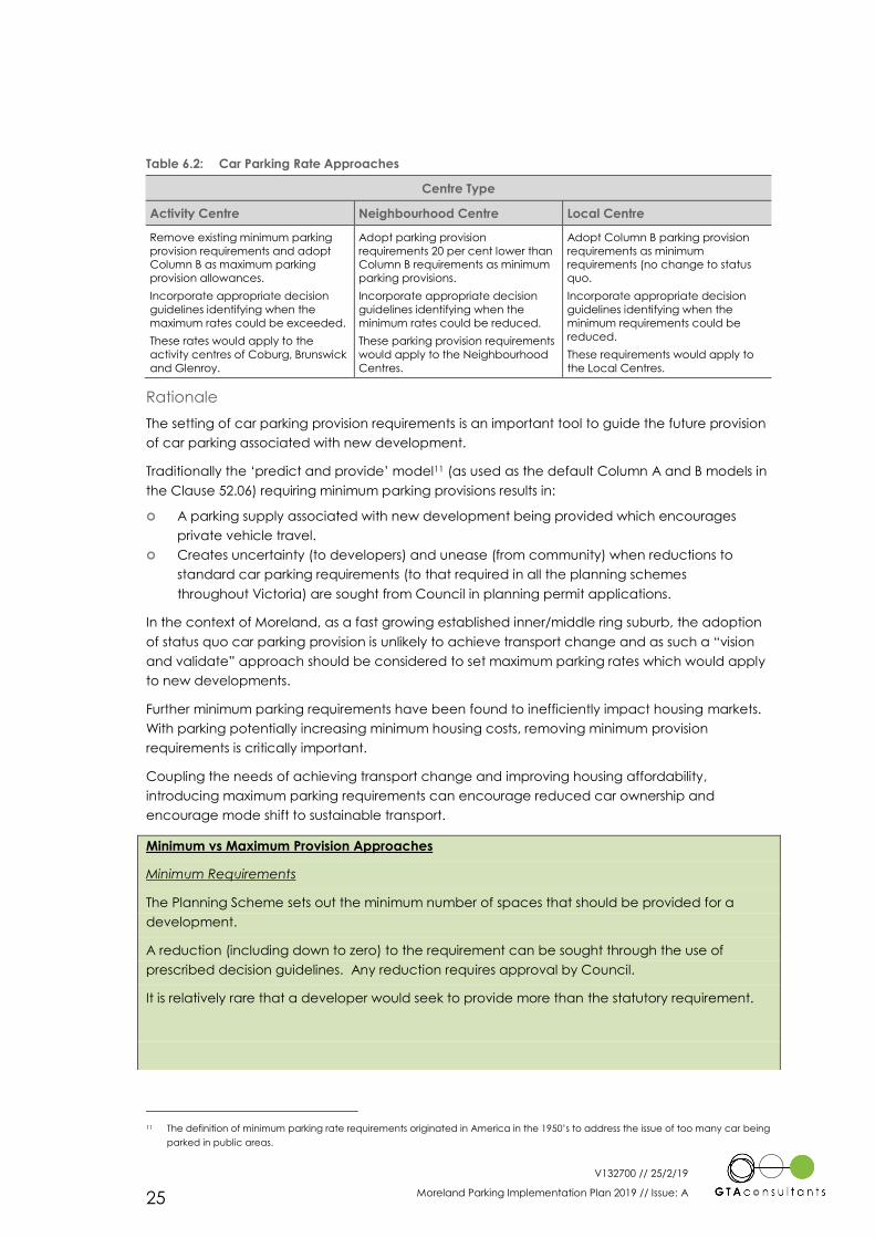
Table 6.2: Car Parking Rate Approaches
Centre Type
Activity Centre Neighbourhood Centre Local Centre
Remove existing minimum parking
provision requirements and adopt
Column B as maximum parking
provision allowances.
Incorporate appropriate decision
guidelines identifying when the
maximum rates could be exceeded.
These rates would apply to the
activity centres of Coburg, Brunswick
and Glenroy.
Adopt parking provision
requirements 20 per cent lower than
Column B requirements as minimum
parking provisions.
Incorporate appropriate decision
guidelines identifying when the
minimum rates could be reduced.
These parking provision requirements
would apply to the Neighbourhood
Centres.
Adopt Column B parking provision
requirements as minimum
requirements (no change to status
quo.
Incorporate appropriate decision
guidelines identifying when the
minimum requirements could be
reduced.
These requirements would apply to
the Local Centres.
Rationale
The setting of car parking provision requirements is an important tool to guide the future provision
of car parking associated with new development.
Traditionally the ‘predict and provide’ model11 (as used as the default Column A and B models in
the Clause 52.06) requiring minimum parking provisions results in:
A parking supply associated with new development being provided which encourages
private vehicle travel.
Creates uncertainty (to developers) and unease (from community) when reductions to
standard car parking requirements (to that required in all the planning schemes
throughout Victoria) are sought from Council in planning permit applications.
In the context of Moreland, as a fast growing established inner/middle ring suburb, the adoption
of status quo car parking provision is unlikely to achieve transport change and as such a “vision
and validate” approach should be considered to set maximum parking rates which would apply
to new developments.
Further minimum parking requirements have been found to inefficiently impact housing markets.
With parking potentially increasing minimum housing costs, removing minimum provision
requirements is critically important.
Coupling the needs of achieving transport change and improving housing affordability,
introducing maximum parking requirements can encourage reduced car ownership and
encourage mode shift to sustainable transport.
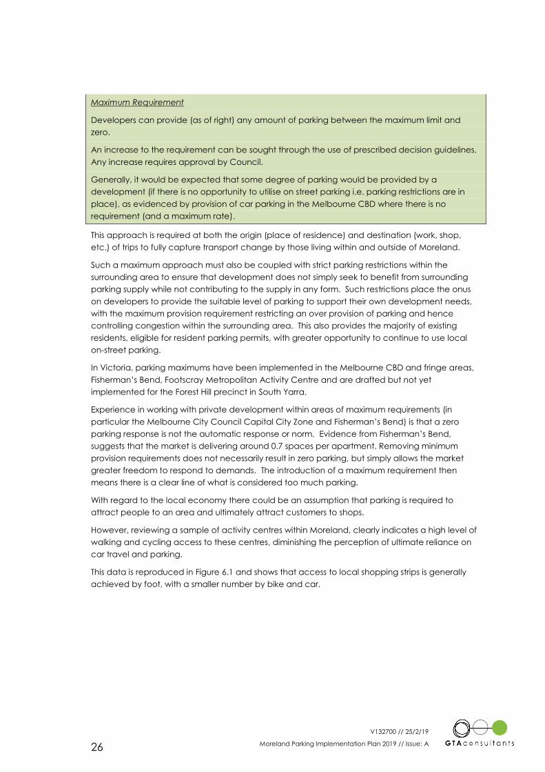
Minimum vs Maximum Provision Approaches
Minimum Requirements
The Planning Scheme sets out the minimum number of spaces that should be provided for a
development.
A reduction (including down to zero) to the requirement can be sought through the use of
prescribed decision guidelines. Any reduction requires approval by Council.
It is relatively rare that a developer would seek to provide more than the statutory requirement.
11 The definition of minimum parking rate requirements originated in America in the 1950’s to address the issue of too many car being
parked in public areas.
V132700 // 25/2/19
Moreland Parking Implementation Plan 2019 // Issue: A 26
Maximum Requirement
Developers can provide (as of right) any amount of parking between the maximum limit and
zero.
An increase to the requirement can be sought through the use of prescribed decision guidelines.
Any increase requires approval by Council.
Generally, it would be expected that some degree of parking would be provided by a
development (if there is no opportunity to utilise on street parking i.e. parking restrictions are in
place), as evidenced by provision of car parking in the Melbourne CBD where there is no
requirement (and a maximum rate).
This approach is required at both the origin (place of residence) and destination (work, shop,
etc.) of trips to fully capture transport change by those living within and outside of Moreland.
Such a maximum approach must also be coupled with strict parking restrictions within the
surrounding area to ensure that development does not simply seek to benefit from surrounding
parking supply while not contributing to the supply in any form. Such restrictions place the onus
on developers to provide the suitable level of parking to support their own development needs,
with the maximum provision requirement restricting an over provision of parking and hence
controlling congestion within the surrounding area. This also provides the majority of existing
residents, eligible for resident parking permits, with greater opportunity to continue to use local
on-street parking.
In Victoria, parking maximums have been implemented in the Melbourne CBD and fringe areas,
Fisherman’s Bend, Footscray Metropolitan Activity Centre and are drafted but not yet
implemented for the Forest Hill precinct in South Yarra.
Experience in working with private development within areas of maximum requirements (in
particular the Melbourne City Council Capital City Zone and Fisherman’s Bend) is that a zero
parking response is not the automatic response or norm. Evidence from Fisherman’s Bend,
suggests that the market is delivering around 0.7 spaces per apartment. Removing minimum
provision requirements does not necessarily result in zero parking, but simply allows the market
greater freedom to respond to demands. The introduction of a maximum requirement then
means there is a clear line of what is considered too much parking.
With regard to the local economy there could be an assumption that parking is required to
attract people to an area and ultimately attract customers to shops.
However, reviewing a sample of activity centres within Moreland, clearly indicates a high level of
walking and cycling access to these centres, diminishing the perception of ultimate reliance on
car travel and parking.
This data is reproduced in Figure 6.1 and shows that access to local shopping strips is generally
achieved by foot, with a smaller number by bike and car.
V132700 // 25/2/19
Moreland Parking Implementation Plan 2019 // Issue: A 27
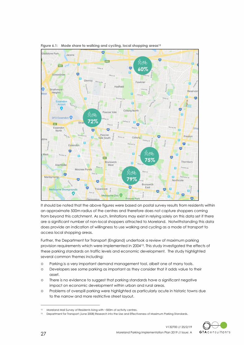
Figure 6.1: Mode share to walking and cycling, local shopping areas12
It should be noted that the above figures were based on postal survey results from residents within
an approximate 500m radius of the centres and therefore does not capture shoppers coming
from beyond this catchment. As such, limitations may exist in relying solely on this data set if there
are a significant number of non-local shoppers attracted to Moreland. Notwithstanding this data
does provide an indication of willingness to use walking and cycling as a mode of transport to
access local shopping areas.
Further, the Department for Transport (England) undertook a review of maximum parking
provision requirements which were implemented in 200413. This study investigated the effects of
these parking standards on traffic levels and economic development. The study highlighted
several common themes including:
Parking is a very important demand management tool, albeit one of many tools.
Developers see some parking as important as they consider that it adds value to their
asset.
There is no evidence to suggest that parking standards have a significant negative
impact on economic development within urban and rural areas.
Problems of overspill parking were highlighted as particularly acute in historic towns due
to the narrow and more restrictive street layout.
12 Moreland Mail Survey of Residents living with ~500m of activity centres.
13 Department for Transport (June 2008) Research into the Use and Effectiveness of Maximum Parking Standards.
V132700 // 25/2/19
Moreland Parking Implementation Plan 2019 // Issue: A 28
Furthermore, from studies in Camden, UK, there is no evidence to suggest that parking maximums
have had an economic impact on the financial viability of development.14
On the basis of the above there is evidence upon which to conclude that in areas of good
transport accessibility, limiting the provision of parking is parking maximisation limits are an
effective lever to promote sustainable transport and reduce congestion.
The application of a maximum provision approach must however also be considered in the
context of activity centre types across Moreland. In this regard the following provides a discussion
around the differing activity centre types and the parking rate approaches that should be
considered for each.
Activity Centres
These centres, previously called Major Activity Centres, are the key centres that must be targeted
to achieve transport change targets set by the MITS.
These centres can most tolerate reduced car parking provisions and the need to change mode
given their improved access to transport alternatives and the mix of uses available which can
allow for the sharing of parking between uses. These are also the centres that will see the most
severe increase in congestion and other traffic related issues if measures to reduce numbers of
cars are not taken.
Parking Provision Response
In order to force change in these centres (not allowing an over provision of parking) it is
recommended that minimum parking provision requirements be removed and replaced with the
imposing of a maximum car parking provision approach.
By way of example, a 1 or 2-bedroom dwelling would be able to provide a maximum of 1 car
space.
Parking Provision Response
It is, recognised that across Activity Centres that some differences in Car Ownership (and Journey
to work) characteristics exist.
Table 6.3: Car Ownership Characteristics15
Location Car Ownership (veh. per dwelling) Journey to Work by Car
Coburg 1.44 59%
Brunswick 1.13 41%
Glenroy 1.54 73%
With the restriction of on-street parking and overspill into adjacent areas it could be expected,
based on the above data, to result in higher rates of off-street parking being delivered in Glenroy
in the short term.
As such the setting of maximum car parking provision requirements at the point of Column B (the
current minimum requirements set) for these areas allows for flexibility across each centre for the
market to respond accordingly and provide parking as needed.
While this approach technically allows parking to be provided as currently required, evidence
from the introduction of parking maximums indicates that the adoption of a maximum rate will
naturally encourage and create change in reducing car parking provision and private vehicle
travel patterns.
14 http://www.camden.gov.uk/ccm/cms-service/stream/asset/?asset_id=3414526
15 2016 ABS Census Data
V132700 // 25/2/19
Moreland Parking Implementation Plan 2019 // Issue: A 29
The adoption of a maximum starting point at Column B should, however, be monitored to ensure
that change does occur in the way in which parking is provided to meet with the overarching
aims of the strategy. Should parking provisions not be reduced as expected, it may be necessary
to set reduced maximum requirements to further force change in car parking provisions.
A review of planning applications over the coming 3 years could provide an understanding of
development trends and willingness to adopt car parking provisions below the maximum limit.
Decision Guidelines
Decision Guidelines to supplement the recommended car parking provision requirements within
a Parking Overlay should be developed with the following intent:
Decision Guidelines would reflect requirements to be satisfied to support a provision of
parking greater than the maximum car parking provisions allowed.
Allow consideration of empirical data and specific use or user requirements which may
give rise to a higher parking requirement.
Justification should be required of why the characteristics of the proposed use (with
regard to the likely car parking demands generated) can’t be accommodated by
other forms of transport than the private car.
The appropriateness of the impact of increased parking provisions on road network
capacity, pedestrian safety and urban design should be justified.
The extent demonstrated to which sustainable transport provisions are being
incorporated within the development to support and encourage trips being made by
non-car modes.
Demonstrate the ability for parking to be repurposed in future years.
Reiterate that occupiers of any dwellings approved by permit subject to the provisions
of this schedule may not be eligible for Resident Priority Parking Permits.
Neighbourhood Centres
These centres will experience growth in activity and mix of commercial and residential uses in
coming years. They are therefore centres that should also be targeted to achieve transport
change targets set by the MITS.
These are centres that can tolerate reduced car parking provisions and the need to change
mode given their improved access to transport alternatives.
The surrounds of these centres are however often more sensitive to parking overspill and therefore
a more careful balancing of parking provision should be considered.
Parking Rate Response
The adoption of reduced minimum parking provision requirements would be an appropriate
response to encourage change in these centres. This does however allow the market to respond
if higher provisions are considered necessary, however would not be encouraged.
Parking Provision Response
Car parking provision requirements specified by Clause 52.06 of the Moreland Planning Scheme
reflect the Victorian Planning Provisions which apply across all of Metropolitan Melbourne (where
a Parking Overlay has not been put into place). As such a comparison of these statewide
requirements has been undertaken to understand how they could be tailored to better reflect
the City of Moreland and the aspirations to achieve mode shift away from private car travel.
In this regard a number of travel data sources have been considered comparing Metropolitan
Melbourne characteristics with that of the Moreland Local Government Area. These sources
included:
V132700 // 25/2/19
Moreland Parking Implementation Plan 2019 // Issue: A 30
Australian Bureau of Statistics Journey to Work Data
Australian Bureau of Statistics Car Ownership Data
Victorian Integrated Surveys of Travel and Activity (Vista) Total Trips Data.
These sources are identified in Table 6.4.
Table 6.4: Percentage Comparison of Car Demand between Metropolitan Melbourne and Moreland
Data Source Moreland Metropolitan Melbourne Comparison
ABS Journey to Work Car driver – 55 per cent Car driver – 70 per cent 22 per cent
Vista Total Trips Car driver – 46 per cent Car driver – 52 per cent 11 per cent
ABS Car Ownership Vehicles per dwelling - 1.40 Vehicles per dwelling - 1.69 17 per cent
Average difference 10 to 20 per cent
Table 6.4 indicates that Moreland has a 10 to 20 per cent reduction in car use demand when
compared to Metropolitan Melbourne.
As such given Column B provision requirements apply across Metropolitan Melbourne (where
activated by the PPTN), it would be considered reasonable that a reduction to these
requirements by 10 to 20 per cent could be applied to better reflect travel characteristics within
Moreland and set an appropriate ‘baseline’ for the consideration of parking provision in
Neighbourhood Centres. Having further regard to the aspirational targets of increasing mode
shift to sustainable transport modes it would be right to adopt the higher of the potential
reductions being 20 per cent.
This reduction is also consistent with previous parking strategies for Coburg and Brunswick which
suggested a 20% reduction to Column B requirements could be applied. While Neighbourhood
centres may not traditionally have the same access to alternate transport and density of uses as
the Activity Centres of Brunswick, Coburg and Glenroy, the adoption of lower minimum provisions
is required to create transport change.
The use of lower minimum provision (20 per cent reduction to Column B) therefore encourages
change, however allows the market to respond and provide higher parking if required.
The adoption of decision guidelines (to further reduce parking provisions) should also supplement
the minimum provision approach to further allow for lower provisions to be adopted and
therefore the market to respond on a case by case basis. Such decision guidelines recognise
that across Neighbourhood centres differing levels access are available which could also
influence the required level of parking.
Decision Guidelines
Further to the above, decision guidelines to supplement the recommended car parking provision
requirements within a Parking Overlay should be developed with the following intent:
Decision Guidelines would reflect requirements to be satisfied to support a provision of
parking lower than the minimum car parking provision requirements allowed.
Decision guidelines should be supportive of reducing parking requirements where
justification can be provided.
Allow consideration of empirical data and specific use or user requirements which may
give rise to a lower parking requirement.
Justification should be required of why the characteristics of the proposed use (with
regard to the likely car parking demands generated) can’t be accommodated by
other forms of transport than the private car.
The impact of reduced parking provisions must be considered in the context of the
surrounding available car parking supplies and availability.
V132700 // 25/2/19
Moreland Parking Implementation Plan 2019 // Issue: A 31
The appropriateness of the impact of reduced parking provisions on road network
capacity, pedestrian safety and urban design should be considered.
The extent to which sustainable transport provisions are being incorporated within the
development to support and encourage trips being made by non-car modes.
Reiterate that occupiers of any dwellings approved by permit subject to the provisions
of this schedule may not be eligible for Resident Priority Parking Permits.
Local Centres
These centres are expected to experience limited growth in coming years, and as such their
contribution (from a provision of future parking) to achieving the objectives of MITS is also likely to
be limited.
The relevance therefore of trying to define specific requirements for these centres is limited and
could continue dealt with on a case by case scenario.
Parking Rate Response
The adoption of minimum parking provision requirements would be an appropriate response for
these centres. This maintains the current approach as is applicable to these centres.
Parking Provision Response
The adoption of Column B requirements as currently is applicable allows for the sharing of parking
between uses to be considered but also for the market to respond if higher provisions are
considered necessary, however these would not be encouraged.
The adoption of decision guidelines (to further reduce parking provisions) should also supplement
the minimum provision approach to further allow for lower provisions to be adopted and
therefore the market to respond on a case by case basis.
Decision Guidelines
Further to the above, the intent of decision guidelines to supplement the recommended car
parking provision requirements within a Parking Overlay would generally be expected to be the
same as those specified for Neighbourhood Centres.
6.1.2 Designing for the future
It is well recognised that the nature of transport is changing, and this will impact in some way the
manner in which parking is provided in the future. However, the extent of change is not defined
at this time and is likely to occur, in the most part, outside of the timeframe of this Implementation
Plan. A number of elements however that could be predicted, at least in general terms, include
the following:
The way vehicles are powered is changing with the growing prevalence of electric
vehicles in the vehicle fleet. The cost of these vehicles is also declining making
ownership of these vehicles more accessible to more people.
The demand for parking (on a per capita basis) could be expected to decrease with
an increased accessibility to ride sharing services, car sharing services, home delivery
services etc.
In light of the above, it is recommended that the design for any new car parking within Moreland
should be designed to allow for:
Vehicle charging opportunities or at a minimum provision of electrical infrastructure to
allow for the future installation of charging points. The provision of such infrastructure
should be considered now in new buildings to avoid costly retrofitting of building
services or alternately a lack of charging provisions.
V132700 // 25/2/19
Moreland Parking Implementation Plan 2019 // Issue: A 32
Potential alternative uses of car parking space in the future. This will provide support to
the need for places to be flexible to the communities needs and ultimately save money
in the long run. As such, minimum floor to floor heights of above ground structured
parking levels should be designed to enable future repurposing.
The considerations could be included as an encouraged design response within a Design
Standards section of a Parking Overlay.
6.1.3 Car Share
To further support maximum and reduced car parking provision requirements, car share provides
a convenient option to enable access to a car but removes the need to own a vehicle.
Cars typically spend 95 per cent of their life unused, representing a very inefficient use of space
and resources. Car share provides convenient access to a car for trips where alternative modes
are not a viable option. Some service providers estimate that one share car can replace up to 15
private vehicles, significantly reducing the space required to store private cars and reducing the
costs of purchasing and operating a car for a number of would-be owners.16
As such Council should support a greater roll-out of share cars to help residents choose to reduce
the number of cars they own. This should include:
Repurposing general use car spaces for car share spaces in key areas (for example,
activity centres, areas with a high-density residential areas).
Encouraging developments to provide externally accessible car share spaces on-site.
Encourage developments to fund memberships for nearby car share schemes under
the implementation of a green travel plan.
16 The Sharing Economy, Transport Matters, GTA Consultants,
http://www.gta.com.au/transportmatters/transportmatters_vol9_issue4_web.pdf, accessed 22/04/18
V132700 // 25/2/19
Moreland Parking Implementation Plan 2019 // Issue: A 33
Reallocation of road space and existing car parking
6.2.1 Reallocating Space for Movement
Moreland is growing. To cater for this demand sustainably, change will be required to the way
that space is allocated on the road network. Parking is part of this mix, as on most streets it takes
up similar space to the traffic lanes and is double the width of the footpath.
Parking, however, remains important to the community and there is some distance to travel to
achieve greater sustainability in this regard.
The actions identified create a clear line for assessing street improvement schemes, but also take
an area-wide perspective. This does not mean just listening to the loudest voices but listening to
a wide range of people, as has been done in developing MITS.
The community has been asked about what they want from a parking policy for Moreland.
Solving the issues that were consistently raised in this consultation, such as congestion, safety
and liveability, means rethinking the way the community value parking.
“If you intend to get more people on bikes, choosing active transport, healthy, lower pollution,
liveability, there is no other way to do it than provide the space on roads, with safe protected
bike lanes – NOT thin strips next to opening car doors or a bit of paint with arrows here and there.
Please start removing on-street parking and replacing it with bike lanes. Coburg has a sea of car
parking off-street behind both sides of Sydney Road, it is not needed on the street as well.”
While most parking across the wider Moreland area will be retained, these actions open the door
for some parking to be reallocated to sustainable transport, improving safety of active transport
modes and the creation of better places within Moreland. This will create a better balance
between parking and other uses of road space. It also helps Moreland transition to an area that
one day will have more people walking than driving the car.
While the conversation needs to occur with individual communities to be impacted by any such
removals of parking, as a general rule, parking demands are not constrained across the
municipality such that the removal of parking at key locations cannot be tolerated and
absorbed by the surrounding area. Indeed, the removal of parking will bring alternate benefits
that, on the whole, are likely to outweigh the removal of parking. As such, it is important to
understand the function of a street when determining if and what type of parking should be
made available on it. For example, a street might support on-street parking during off-peak times
but during peak time parking spaces would be better utilised as a bus lane which can improve
access for a significant number of people.
On this basis parking could be considered for removal when it provides an overall benefit to the
sustainable movement of people in circumstances such as:
Improves pedestrian linkages, pathways and connections
Improves the operation and capacity of public transport routes
Improves cycling corridors and connectivity.
V132700 // 25/2/19
Moreland Parking Implementation Plan 2019 // Issue: A 34
6.2.2 Reallocating Space for Safety
A safe and healthy Moreland is one where active transport is the first and obvious choice for
many commuters and travellers, and where people have a broad range of choices available to
them.
Sustainable transport modes encourage physical exercise which benefits the body and mind.
Being stuck in traffic jams, waiting at traffic lights and breathing in fumes from vehicles is not
healthy.
It is however understood from community feedback that it is currently common for cars to be
parked in ways that jeopardise the safety of the community.
“Sadly, too much priority is given to cars. Most space in important roads such as Sydney Rd
and Lygon St is given to cars in the form of parking.” & “When biking down one of these
main streets, there is a constant high risk of being doored by careless drivers.”
Parking must ensure that it does not impose on the safety of people using other modes. This is
particularly relevant along cycling routes and around schools.
To improve road safety, parked vehicles must not hinder the safety of other modes. Similar to
above, parking should be given less priority where required to improve safety.
6.2.3 Reallocating Space for Place
In a similar manner to the above, creating great places in Moreland is also important to the
function and attractiveness of its activity centres.
The importance of places for people to dwell and experience the centres and neighbourhood
areas helps to encourage sustainable transport modes being used.
Again, conversations will be needed with individual communities. However, as a general rule,
parking demands are not constrained across the municipality such that the removal of some
parking at key locations cannot be tolerated and absorbed by the surrounding area in order to
create better ‘places’. As such, as part of any future discussions on the potential for reallocation
of parking space to other modes, how consumers currently travel should be included as part of
the conversation.
Parking should therefore be considered for removal when it is demonstrated to provide an overall
benefit to the creation of ‘places’ in Moreland. This could include circumstances such as, but not
limited to:
Creating new green spaces
Creating places for sustainable transport end of trip facilities
Creating improved outdoor dining, and
Creating improved places for storage of vehicles for those with reduced mobility and
for sustainable vehicles.
Better manage parking resources
6.3.1 Parking Restrictions
Currently significant parking restrictions are in place within Moreland to manage and fairly
allocate public parking resources. The setting of parking restrictions is identified by the Moreland
Parking Management Policy. This policy is however typically reactive in dealing with parking
overspill issues.
V132700 // 25/2/19
Moreland Parking Implementation Plan 2019 // Issue: A 35
The actions identified as part of this Implementation Plan seek to take a proactive approach to
managing parking, in order to control parking overspill and create a parking environment which
supports the removal of parking minimums within Activity Centres.
In addition to existing controls, Council should also ensure that all public parking resources in and
around activity centres and key destinations are time-restricted or provided as permit parking to
ensure vehicles are not stored on-street over the long-term except as permitted by parking
permits for those residents eligible for parking permits, and to encourage fair use of a restricted
resource. In this regard it would be typically expected that, as a minimum, all on-street parking
would be restricted within Neighbourhood Centres and within 200m of Activity Centres.
The use of a 2-hour restriction (2P) Monday to Friday 8:00am – 11:00pm applied initially to
currently unrestricted spaces would prevent residents of new developments from parking long-
term on street while also providing some flexibility at night and on weekends e.g. for visitor
parking.
More broadly, Council should continue to introduce parking restrictions in other areas as required,
consistent with the Parking Management Policy.
These restrictions will become increasingly important to achieving demonstrable mode shift
particularly in supporting lower car parking rates for new developments.
6.3.2 Parking Permits
At present, Moreland charges only nominal fees for residential car parking and business car
parking permits. Consistent with the directions of MITS to charge more fairly for the use of road
space to store private vehicles, Council should review fees for car parking permits to ensure they
reflect use of space and seek to discourage car ownership and use.
In reviewing fee structures consideration should however also be given to the expansion of
concession discounts (on parking permits) to address social equity concerns. In this regard it is
understood that Council is proposing to expand concession discounts on annual and visitor
permits to include pensioners and Centrelink card holders.
The following permit types will also be included as part of the Parking Management Policy i:
Business Permit Zones – Review the need for expansion based on demand once new
on-street parking restrictions are in place (as described within Section 6.3.1).
Service permits – short term / daily permits for tradespeople, removalists, etc.
undertaking work within the area.
Flexible permit – A permit type that has limited or no eligibility criteria would provide an
option for people who would otherwise not be eligible but still genuinely need a permit.
This would be accompanied by a significantly higher cost than current standard permit
types which would manage the demand for the permit and reflect the value of the
privileged access to public space (without a subsidy being applied).
The cost of each of the above permits will be reviewed as part of the formation of the Parking
Management Policy and through Council’s Fees and Charges process.
The allocation and pricing of permits could also be used to encourage zero emission vehicles.
Though this has been done in many cities (Oslo17, London) its implementation in Australia is limited
and therefore needs to be explored in detail, including commercial partnership and
enforcement.
17 The Electric Vehicle Capital of the World, The City of Oslo
V132700 // 25/2/19
Moreland Parking Implementation Plan 2019 // Issue: A 36
In reviewing the permit allocations and availabilities above, continued consideration must be
given to how changes and ultimate recommendations align and balance needs along the
spectrum including providing fair access to the parking system through to achieving
demonstrable mode shift (away from private car travel).
The existing process in the Parking Management Policy to appeal a decision by Council not to
issue a parking permit could also be temporarily expanded as a transitional measure. This could
include specifying guidelines for decisions on appeals during and after the transitional period –
currently, no guidelines are specified.
6.3.3 Paid Parking
Demand Management through Parking Price
Historically, the City of Brunswick briefly introduced parking meters along Sydney Road in the
1960s, but traders successfully campaigned to have them removed, and the meters were sold to
the City of South Melbourne, who used them to introduce fee parking into its streets. In the 1980s
and 1990s, Brunswick Council replaced period parking restrictions with fee parking in seven off-
street car parks for people who valued available, convenient parking, whether staying short or
long term.
In the 1980s, there was a high demand for the 30 minute parking spaces in Barkly Street outside
the Barkly Square doors that opened (at that time) to the highly popular deli and café area
where Woolworths is today. This high demand resulted in double parking, causing safety issues for
shoppers, cyclists and traffic. The introduction of parking meters dampened the demand just
enough to remove the double parking. The extension of these on-street parking meters into
Sydney Road was considered in the 1990s but was opposed by traders. More recently Moreland
Council considered extending the parking meters, but traders objected. Traders have expressed
concern that their customers will be driven to free parking centres such as nearby Barkly Square
or High Street, Northcote, or Moonee Ponds.
Ultimately, the pricing of parking is a key demand management tool that can be used to shift the
way in which people travel away from the private car.
This includes encouraging people to travel outside of peak times, avoid travel at all, or change to
other modes which are cheaper, but also more healthy, sustainable and efficient. It can also
provide flexibility where people need to use a parking resource and value it enough to pay for it
e.g. paid parking to access longer-term (e.g. four hours) parking where 2P would otherwise apply.
Achieving mode shift through defining different car parking rates alone (as specified above) is
unlikely to achieve such change as these rates typically only impact new development and will
not influence the way existing parking is used. Therefore, tools such as paid parking are also
required to influence existing parking users. At present, Moreland has only a small amount of paid
on-street car parking (on Barkly Street, Brunswick) and charges for some off-street car parking
areas.
https://www.oslo.kommune.no/english/politics-andadministration/green-oslo/best-practices/the-electric-vehicle-capital-of-the-
world/
V132700 // 25/2/19
Moreland Parking Implementation Plan 2019 // Issue: A 37
Research undertaken on behalf of Infrastructure Victoria has found that more than eight out of
every ten people who drive to work in the weekday peak hours have access to free car parking
at their destination, with two thirds of these people having access to a space with no time
restriction. Only 17 per cent of people who drive to work in the weekday peak pay for their car
parking.18
For those that occasionally use other modes in place of driving in peak hours, the single highest
reason not to drive recognised that ‘parking is a problem at my destination’. Drivers would also
be more likely to take another form of transport if it saved them time, was more reliable or saved
them money.19
To manage demand, Council should seek to introduce paid on-street car parking in appropriate
and strategic locations (such as activity centres and locations with access to alternative modes)
to encourage the turnover of vehicles (ensuring available spaces), more fairly price the use of
roads and encourage visitors to use other modes to access their daily needs. The locations, fees
and timing of delivery should be targeted at areas with parking pressure and be assessed and
extended periodically throughout the day. This will create a higher turnover of parked vehicles
resulting in greater parking opportunities. Introducing paid parking as a demand management
measure will also support the objectives of maximum car parking provision requirements, which
together aim to reduce car ownership and dependence.
Initially paid parking should be investigated to be installed within Activity Centres of Brunswick,
Coburg and Glenroy (on-street commercial frontages and Council off-street car parks including
both short stay and long stay parking). Once established a gradual expansion of paid parking
could occur to cater for all-day parking demand. In a similar manner to the discussion on car
parking provision requirements, these centres are typically those best served by public transport
and would therefore provide the greatest opportunity for alternate transport modes to be
adopted, should drivers seek to change transport mode in response to a parking charge. In
addition, these centres would be more likely to have car parking demands that would warrant a
paid parking introduction (as per Council Parking Management Policy.
Further expansion into Neighbourhood Centres could also be considered in the longer term to
encourage and support achieving demonstrable transport change in Moreland.
More broadly, Council should also advocate to extend the use of pricing to manage demand for
other over-utilised assets, such as railway station car parking. Charging a small fee means that
people who live nearby and drive currently may choose to walk leaving car spaces for those that
have to travel from further afield.
18 Infrastructure Victoria – Managing Transport Demand Community Research – Part 2, December 2017, Quantum Market Research,
http://infrastructurevictoria.com.au/sites/default/files/images/Quantum%20Report%20-
%20Community%20Research%20data%20set%20Part%202.pdf, accessed 23/04/18 – refer Q30.
19 Infrastructure Victoria – Managing Transport Demand Community Research – Part 2, December 2017, Quantum Market Research,
http://infrastructurevictoria.com.au/sites/default/files/images/Quantum%20Report%20-
%20Community%20Research%20data%20set%20Part%202.pdf, accessed 23/04/18 – refer Q21 and Q22.
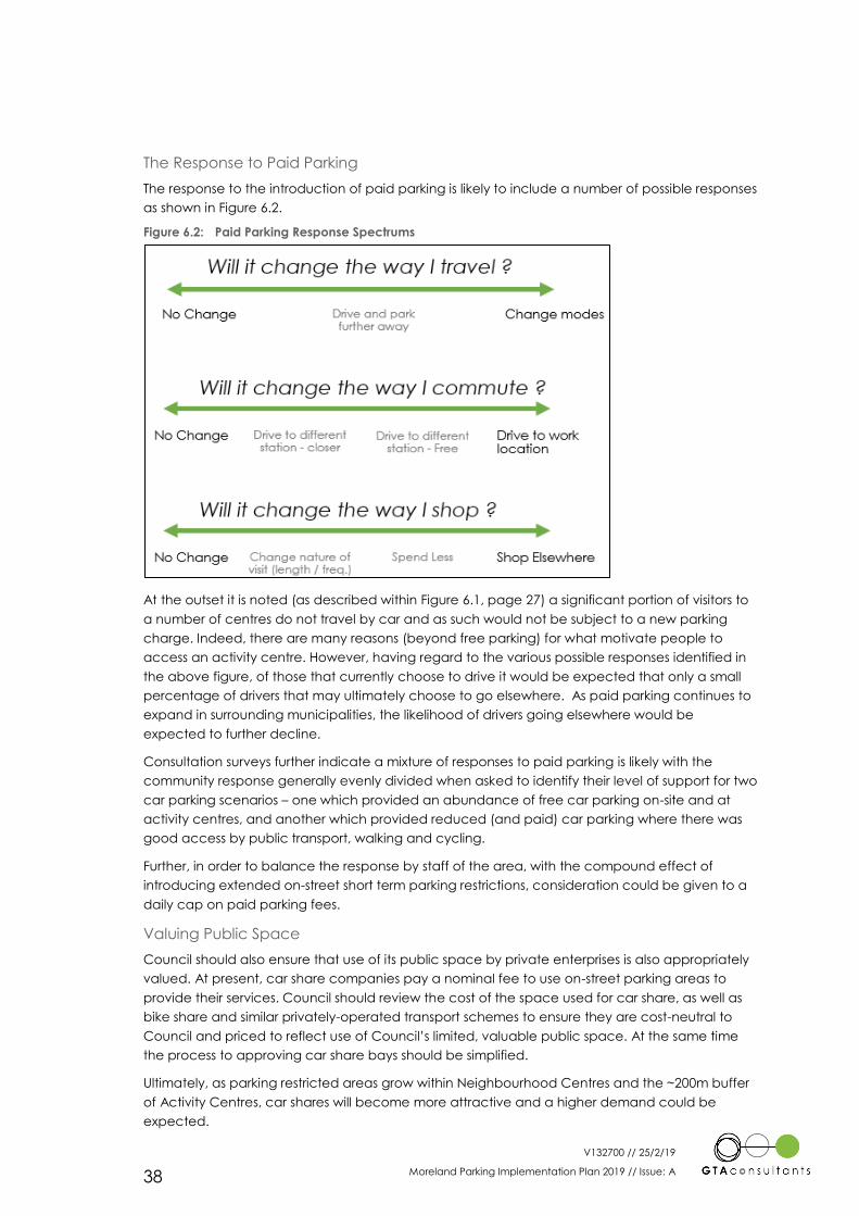
V132700 // 25/2/19
Moreland Parking Implementation Plan 2019 // Issue: A 38
The Response to Paid Parking
The response to the introduction of paid parking is likely to include a number of possible responses
as shown in Figure 6.2.
Figure 6.2: Paid Parking Response Spectrums
At the outset it is noted (as described within Figure 6.1, page 27) a significant portion of visitors to
a number of centres do not travel by car and as such would not be subject to a new parking
charge. Indeed, there are many reasons (beyond free parking) for what motivate people to
access an activity centre. However, having regard to the various possible responses identified in
the above figure, of those that currently choose to drive it would be expected that only a small
percentage of drivers that may ultimately choose to go elsewhere. As paid parking continues to
expand in surrounding municipalities, the likelihood of drivers going elsewhere would be
expected to further decline.
Consultation surveys further indicate a mixture of responses to paid parking is likely with the
community response generally evenly divided when asked to identify their level of support for two
car parking scenarios – one which provided an abundance of free car parking on-site and at
activity centres, and another which provided reduced (and paid) car parking where there was
good access by public transport, walking and cycling.
Further, in order to balance the response by staff of the area, with the compound effect of
introducing extended on-street short term parking restrictions, consideration could be given to a
daily cap on paid parking fees.
Valuing Public Space
Council should also ensure that use of its public space by private enterprises is also appropriately
valued. At present, car share companies pay a nominal fee to use on-street parking areas to
provide their services. Council should review the cost of the space used for car share, as well as
bike share and similar privately-operated transport schemes to ensure they are cost-neutral to
Council and priced to reflect use of Council’s limited, valuable public space. At the same time
the process to approving car share bays should be simplified.
Ultimately, as parking restricted areas grow within Neighbourhood Centres and the ~200m buffer
of Activity Centres, car shares will become more attractive and a higher demand could be
expected.
V132700 // 25/2/19
Moreland Parking Implementation Plan 2019 // Issue: A 39
Satisfying Implementation Criteria
In addition to the above it is noted that the criteria for the introduction of paid parking is
identified by the Moreland Parking Management Policy. This criteria has been traditionally
developed on the basis of using paid parking as a means to more effectively manage and
prioritise the parking resource when demands increase to a level that other management tools
such as parking time limits have become less effective in controlling.
In the context of Moreland at this time, the introduction of paid parking is primarily being
recommended as a demand management tool to achieve demonstrable mode shift away from
the private motor car.
As such, while the criteria defined within the Moreland Parking Management Policy have merit to
assist in managing parking resources, these criteria should not restrict the introduction of paid
parking when it is being used as a Travel Demand Management tool to encourage transport
change.
Using Parking Revenue
Revenue raised from paid parking, as well as from transport-related permit schemes such as
residential and business car parking permits should be returned into improvements to the local
area, or sustainable transport initiatives.
Infrastructure Victoria recommends the car parking congestion levy revenue be shared with local
councils to which the levy applies, as is the case for the City of Melbourne.20
Council should advocate for levy revenue to be shared with Council, which in turn could be
invested in sustainable transport initiatives such as active travel.
6.3.4 Parking Enforcement
The enforcement of parking is critical to the functioning of any parking system to ensure that it
operates in a manner consistent with that in which it is designed.
Most specifically in respect of the desired outcomes of MITS, is the need to prioritise the
enforcement of parking which impacts safety, emergency access and pedestrian and cycle
movements (for example, across footpaths or bicycle lanes, or illegal parking in disabled parking
bays).
20 Car Parks, State Revenue Office Victoria, https://www.sro.vic.gov.au/car-parks, accessed 24/04/18
V132700 // 25/2/19
Moreland Parking Implementation Plan 2019 // Issue: A 40
Statutory Implementation
Overview
As identified earlier within this document (Section 1.4) the implementation of recommendations
will typically fall under statutory or non-statutory actions.
Those actions that require a statutory form typically represent those that place a requirement on
developers or other third parties.
Specifically, the following recommendations contained within MITS and this Parking
Implementation Plan would warrant implementation in a statutory form:
The identification of specific car parking rates and associated decision guidelines for
activity centres within Moreland (as identified in Section 6.1).
The encouragement for new developments to incorporate increased floor to floor
heights in car parking levels to allow for potential future repurposing (as identified in
Section 6.1).
The updating of Council’s Development Contributions Plan (as identified in MITS).
On the most part the recommendations will appropriately be provided with a statutory form
through a Parking Overlay, as a Schedule to Clause 45.09 to the Moreland Planning Scheme.
The exception will be the update to the Development Contributions Plan which has its own
statutory mechanism at Clause 45.06 of the Moreland Planning Scheme.
Preparing a Parking Overlay
In preparing a Parking Overlay a number of specific matters need to be addressed including:
Definition of Objectives
Identifying the area to which the overlay will apply
Identifying car parking rates to be applied
Identifying any relevant decision guidelines
Identifying any specific design requirements.
In principle, these matters are addressed within the above and can be translated into a Schedule
to the Parking Overlay. These requirements have not been specifically reproduced again in this
section of the report.
In preparing the content of the Schedule to the Parking Overlay consideration should also be
given to the inclusion or referencing of the following elements of the Moreland Planning Scheme:
Conversion of the content currently contained within Clause 22.03 – Car and Bike
Parking and Vehicle Access into the proposed Schedule to the Parking Overlay. This
includes policy relating to the provision of car parking (superseded by this
Implementation Plan), the provision of bicycle parking and design requirements.
Conversion of bicycle parking requirements contained within Schedule 1 to the Activity
Centre Zone Clause 10.
While consolidation of the above material would be preferred to a single location in the Planning
Scheme, it may be required that bicycle parking policy also remains as part of the local policy (at
Clause 22.03) as it remains important, not only when considering reducing parking requirements.
7
V132700 // 25/2/19
Moreland Parking Implementation Plan 2019 // Issue: A 41
Preparing a Development Contributions Plan
A Development Contributions Plan (DCP) already exists within the Moreland Planning Scheme,
with it methodology and content tested and approved through a Planning Scheme Amendment
Process. It is recommended that Council therefore should adopt the same or similar process for
the updating of the plan.
Opportunities may exist to substitute some sustainable transport projects within the same charge
area as part of the midpoint review of the DCP. This should be further investigated. Otherwise
inclusion of more significant sustainable transport projects could be included when the next plan
is developed for 2023 – 2024. It is noted that this will form a separate process to the Parking
Overlay preparation identified earlier.
More information on the potential for DCPs to play a role in funding sustainable transport can be
found in the MITS Appendix.
V132700 // 25/2/19
Moreland Parking Implementation Plan 2019 // Issue: A
A1
Existing Parking and Transport Characteristics
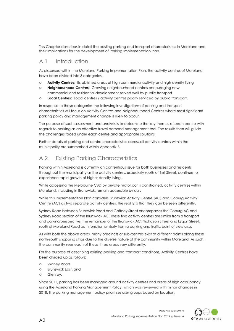
V132700 // 25/2/19
Moreland Parking Implementation Plan 2019 // Issue: A
A2
This Chapter describes in detail the existing parking and transport characteristics in Moreland and
their implications for the development of Parking Implementation Plan.
A.1 Introduction
As discussed within the Moreland Parking Implementation Plan, the activity centres of Moreland
have been divided into 3 categories.
Activity Centres: Established areas of high commercial activity and high density living
Neighbourhood Centres: Growing neighbourhood centres encouraging new
commercial and residential development served well by public transport
Local Centres: Local centres / activity centres poorly serviced by public transport.
In response to these categories the following investigations of parking and transport
characteristics will focus on Activity Centres and Neighbourhood Centres where most significant
parking policy and management change is likely to occur.
The purpose of such assessment and analysis is to determine the key themes of each centre with
regards to parking as an effective travel demand management tool. The results then will guide
the challenges faced under each centre and appropriate solutions.
Further details of parking and centre characteristics across all activity centres within the
municipality are summarised within Appendix B.
A.2 Existing Parking Characteristics
Parking within Moreland is currently an contentious issue for both businesses and residents
throughout the municipality as the activity centres, especially south of Bell Street, continue to
experience rapid growth of higher density living.
While accessing the Melbourne CBD by private motor car is constrained, activity centres within
Moreland, including in Brunswick, remain accessible by car.
While this Implementation Plan considers Brunswick Activity Centre (AC) and Coburg Activity
Centre (AC) as two separate activity centres, the reality is that they can be seen differently.
Sydney Road between Brunswick Road and Gaffney Street encompasses the Coburg AC and
Sydney Road section of the Brunswick AC. These two activity centres are similar from a transport
and parking perspective. The remainder of the Brunswick AC, Nicholson Street and Lygon Street,
south of Moreland Road both function similarly from a parking and traffic point of view also.
As with both the above areas, many precincts or sub-centres exist at different points along these
north-south shopping strips due to the diverse nature of the community within Moreland. As such,
the community sees each of these three areas very differently.
For the purpose of describing existing parking and transport conditions, Activity Centres have
been divided up as follows:
Sydney Road
Brunswick East, and
Glenroy.
Since 2011, parking has been managed around activity centres and areas of high occupancy
using the Moreland Parking Management Policy, which was reviewed with minor changes in
2018. The parking management policy prioritises user groups based on location.
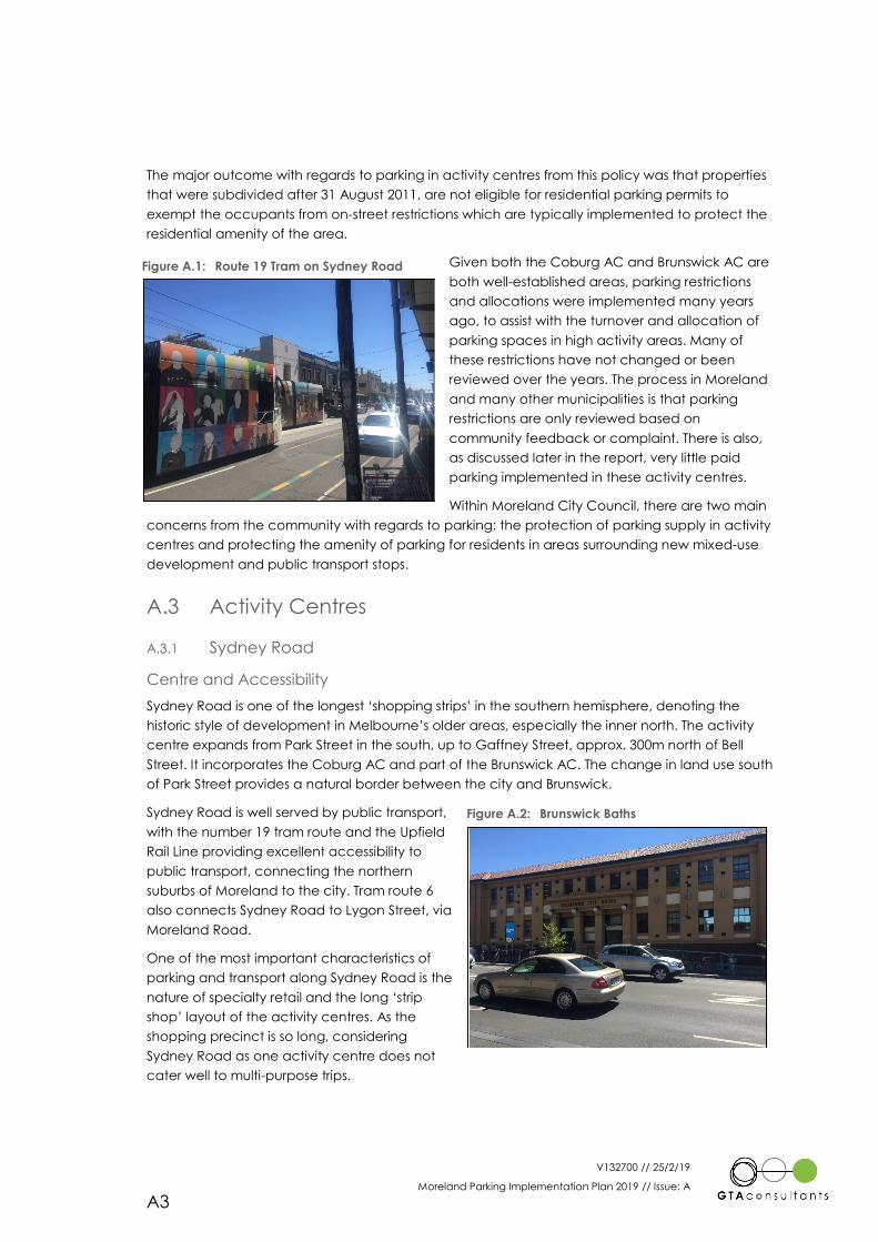
V132700 // 25/2/19
Moreland Parking Implementation Plan 2019 // Issue: A
A3
The major outcome with regards to parking in activity centres from this policy was that properties
that were subdivided after 31 August 2011, are not eligible for residential parking permits to
exempt the occupants from on-street restrictions which are typically implemented to protect the
residential amenity of the area.
Given both the Coburg AC and Brunswick AC are
both well-established areas, parking restrictions
and allocations were implemented many years
ago, to assist with the turnover and allocation of
parking spaces in high activity areas. Many of
these restrictions have not changed or been
reviewed over the years. The process in Moreland
and many other municipalities is that parking
restrictions are only reviewed based on
community feedback or complaint. There is also,
as discussed later in the report, very little paid
parking implemented in these activity centres.
Within Moreland City Council, there are two main
concerns from the community with regards to parking: the protection of parking supply in activity
centres and protecting the amenity of parking for residents in areas surrounding new mixed-use
development and public transport stops.
A.3 Activity Centres
A.3.1 Sydney Road
Centre and Accessibility
Sydney Road is one of the longest ‘shopping strips’ in the southern hemisphere, denoting the
historic style of development in Melbourne’s older areas, especially the inner north. The activity
centre expands from Park Street in the south, up to Gaffney Street, approx. 300m north of Bell
Street. It incorporates the Coburg AC and part of the Brunswick AC. The change in land use south
of Park Street provides a natural border between the city and Brunswick.
Sydney Road is well served by public transport,
with the number 19 tram route and the Upfield
Rail Line providing excellent accessibility to
public transport, connecting the northern
suburbs of Moreland to the city. Tram route 6
also connects Sydney Road to Lygon Street, via
Moreland Road.
One of the most important characteristics of
parking and transport along Sydney Road is the
nature of specialty retail and the long ‘strip
shop’ layout of the activity centres. As the
shopping precinct is so long, considering
Sydney Road as one activity centre does not
cater well to multi-purpose trips.
Figure A.1: Route 19 Tram on Sydney Road
Figure A.2: Brunswick Baths
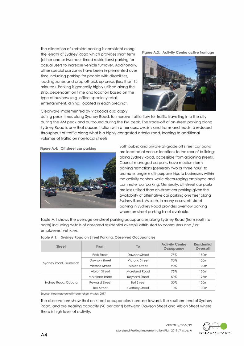
V132700 // 25/2/19
Moreland Parking Implementation Plan 2019 // Issue: A
A4
The allocation of kerbside parking is consistent along
the length of Sydney Road which provides short term
(either one or two hour timed restrictions) parking for
casual users to increase vehicle turnover. Additionally,
other special use zones have been implemented over
time including parking for people with disabilities,
loading zones and drop off-pick up areas (less than 15
minutes). Parking is generally highly utilised along the
strip, dependant on time and location based on the
type of business (e.g. office, specialty retail,
entertainment, dining) located in each precinct.
Clearways implemented by VicRoads also apply
during peak times along Sydney Road, to improve traffic flow for traffic travelling into the city
during the AM peak and outbound during the PM peak. The trade-off of on-street parking along
Sydney Road is one that causes friction with other cars, cyclists and trams and leads to reduced
throughput of traffic along what is a highly congested arterial road, leading to additional
volumes of traffic on non-local streets.
Both public and private at-grade off street car parks
are located at various locations to the rear of buildings
along Sydney Road, accessible from adjoining streets.
Council managed carparks have medium term
parking restrictions (generally two or three hour) to
promote longer multi-purpose trips to businesses within
the activity centres, while discouraging employee and
commuter car parking. Generally, off-street car parks
are less utilised than on-street car parking given the
availability of alternative car parking on-street along
Sydney Road. As such, in many cases, off-street
parking in Sydney Road provides overflow parking
where on-street parking is not available.
Table A.1 shows the average on-street parking occupancies along Sydney Road (from south to
north) including details of observed residential overspill attributed to commuters and / or
employees’ vehicles.
Table A.1: Sydney Road on Street Parking, Observed Occupancies
Street From To Activity Centre
Occupancy
Residential
Overspill
Sydney Road, Brunswick
Park Street Dawson Street 75% 150m
Dawson Street Victoria Street 90% 150m
Victoria Street Albion Street 90% 100m
Albion Street Moreland Road 75% 150m
Sydney Road, Coburg
Moreland Road Reynard Street 50% 125m
Reynard Street Bell Street 50% 150m
Bell Street Gaffney Street 10% 100m
Source: Nearmap aerial image taken 4th May 2017
The observations show that on-street occupancies increase towards the southern end of Sydney
Road, and are nearing capacity (90 per cent) between Dawson Street and Albion Street where
there is high level of activity.
Figure A.3: Activity Centre active frontage
Figure A.4: Off street car parking
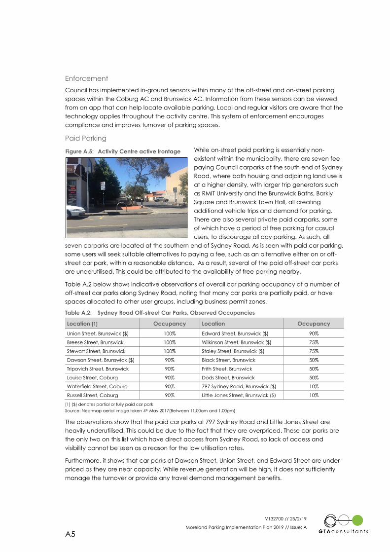
V132700 // 25/2/19
Moreland Parking Implementation Plan 2019 // Issue: A
A5
Enforcement
Council has implemented in-ground sensors within many of the off-street and on-street parking
spaces within the Coburg AC and Brunswick AC. Information from these sensors can be viewed
from an app that can help locate available parking. Local and regular visitors are aware that the
technology applies throughout the activity centre. This system of enforcement encourages
compliance and improves turnover of parking spaces.
Paid Parking
While on-street paid parking is essentially non-
existent within the municipality, there are seven fee
paying Council carparks at the south end of Sydney
Road, where both housing and adjoining land use is
at a higher density, with larger trip generators such
as RMIT University and the Brunswick Baths, Barkly
Square and Brunswick Town Hall, all creating
additional vehicle trips and demand for parking.
There are also several private paid carparks, some
of which have a period of free parking for casual
users, to discourage all day parking. As such, all
seven carparks are located at the southern end of Sydney Road. As is seen with paid car parking,
some users will seek suitable alternatives to paying a fee, such as an alternative either on or off-
street car park, within a reasonable distance. As a result, several of the paid off-street car parks
are underutilised. This could be attributed to the availability of free parking nearby.
Table A.2 below shows indicative observations of overall car parking occupancy at a number of
off-street car parks along Sydney Road, noting that many car parks are partially paid, or have
spaces allocated to other user groups, including business permit zones.
Table A.2: Sydney Road Off-street Car Parks, Observed Occupancies
Location [1] Occupancy Location Occupancy
Union Street, Brunswick ($) 100% Edward Street, Brunswick ($) 90%
Breese Street, Brunswick 100% Wilkinson Street, Brunswick ($) 75%
Stewart Street, Brunswick 100% Staley Street, Brunswick ($) 75%
Dawson Street, Brunswick ($) 90% Black Street, Brunswick 50%
Tripovich Street, Brunswick 90% Frith Street, Brunswick 50%
Louisa Street, Coburg 90% Dods Street, Brunswick 50%
Waterfield Street, Coburg 90% 797 Sydney Road, Brunswick ($) 10%
Russell Street, Coburg 90% Little Jones Street, Brunswick ($) 10%
[1] ($) denotes partial or fully paid car park
Source: Nearmap aerial image taken 4th May 2017(Between 11.00am and 1.00pm)
The observations show that the paid car parks at 797 Sydney Road and Little Jones Street are
heavily underutilised. This could be due to the fact that they are overpriced. These car parks are
the only two on this list which have direct access from Sydney Road, so lack of access and
visibility cannot be seen as a reason for the low utilisation rates.
Furthermore, it shows that car parks at Dawson Street, Union Street, and Edward Street are under-
priced as they are near capacity. While revenue generation will be high, it does not sufficiently
manage the turnover or provide any travel demand management benefits.
Figure A.5: Activity Centre active frontage
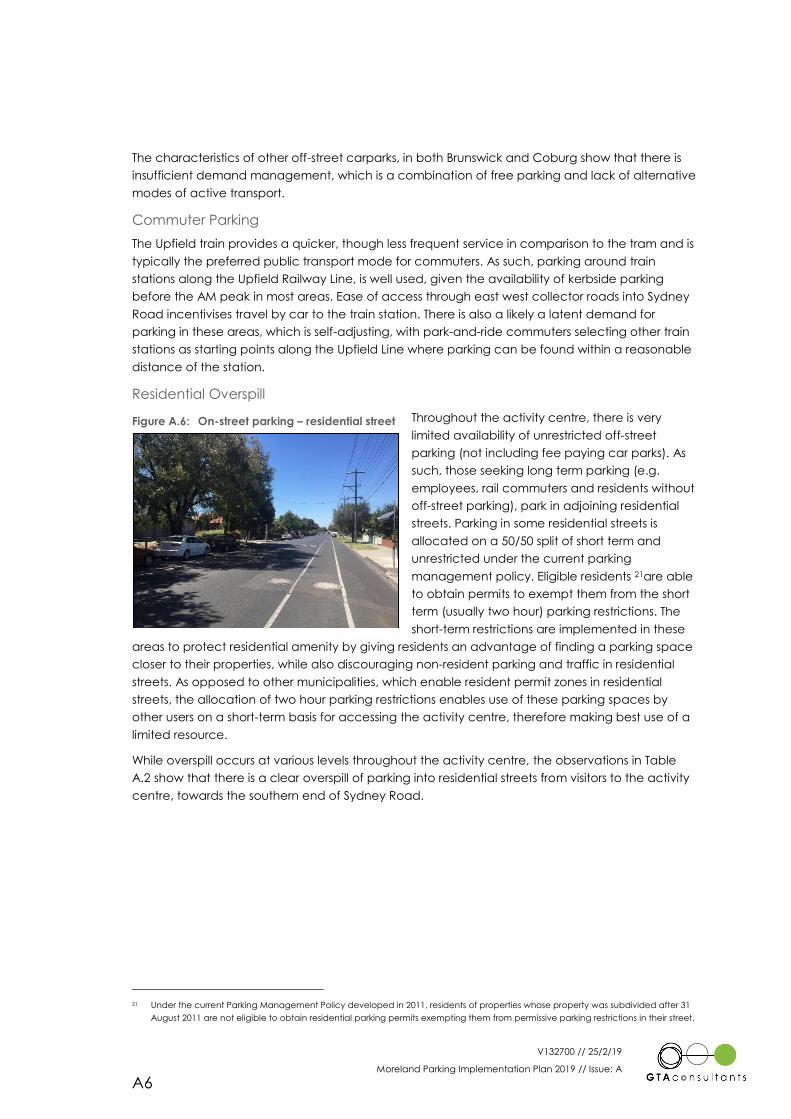
V132700 // 25/2/19
Moreland Parking Implementation Plan 2019 // Issue: A
A6
The characteristics of other off-street carparks, in both Brunswick and Coburg show that there is
insufficient demand management, which is a combination of free parking and lack of alternative
modes of active transport.
Commuter Parking
The Upfield train provides a quicker, though less frequent service in comparison to the tram and is
typically the preferred public transport mode for commuters. As such, parking around train
stations along the Upfield Railway Line, is well used, given the availability of kerbside parking
before the AM peak in most areas. Ease of access through east west collector roads into Sydney
Road incentivises travel by car to the train station. There is also a likely a latent demand for
parking in these areas, which is self-adjusting, with park-and-ride commuters selecting other train
stations as starting points along the Upfield Line where parking can be found within a reasonable
distance of the station.
Residential Overspill
Throughout the activity centre, there is very
limited availability of unrestricted off-street
parking (not including fee paying car parks). As
such, those seeking long term parking (e.g.
employees, rail commuters and residents without
off-street parking), park in adjoining residential
streets. Parking in some residential streets is
allocated on a 50/50 split of short term and
unrestricted under the current parking
management policy. Eligible residents 21are able
to obtain permits to exempt them from the short
term (usually two hour) parking restrictions. The
short-term restrictions are implemented in these
areas to protect residential amenity by giving residents an advantage of finding a parking space
closer to their properties, while also discouraging non-resident parking and traffic in residential
streets. As opposed to other municipalities, which enable resident permit zones in residential
streets, the allocation of two hour parking restrictions enables use of these parking spaces by
other users on a short-term basis for accessing the activity centre, therefore making best use of a
limited resource.
While overspill occurs at various levels throughout the activity centre, the observations in Table
A.2 show that there is a clear overspill of parking into residential streets from visitors to the activity
centre, towards the southern end of Sydney Road.
21 Under the current Parking Management Policy developed in 2011, residents of properties whose property was subdivided after 31
August 2011 are not eligible to obtain residential parking permits exempting them from permissive parking restrictions in their street.
Figure A.6: On-street parking – residential street
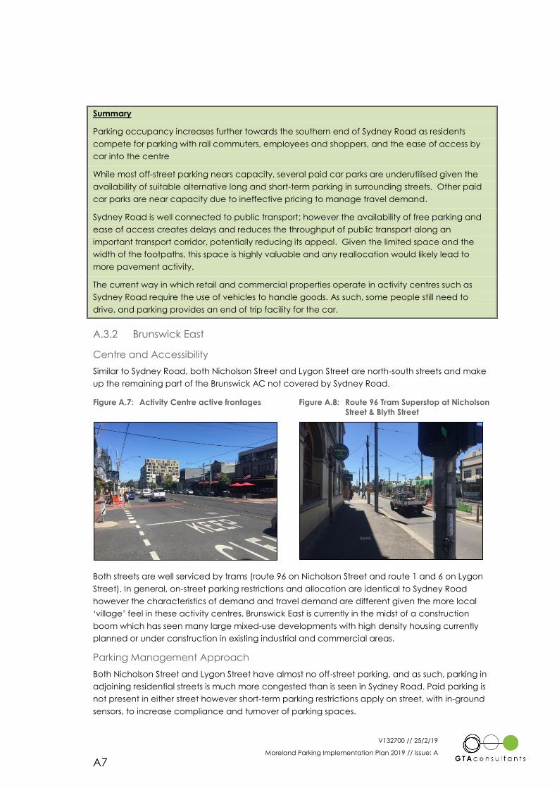
V132700 // 25/2/19
Moreland Parking Implementation Plan 2019 // Issue: A
A7
Summary
Parking occupancy increases further towards the southern end of Sydney Road as residents
compete for parking with rail commuters, employees and shoppers, and the ease of access by
car into the centre
While most off-street parking nears capacity, several paid car parks are underutilised given the
availability of suitable alternative long and short-term parking in surrounding streets. Other paid
car parks are near capacity due to ineffective pricing to manage travel demand.
Sydney Road is well connected to public transport; however the availability of free parking and
ease of access creates delays and reduces the throughput of public transport along an
important transport corridor, potentially reducing its appeal. Given the limited space and the
width of the footpaths, this space is highly valuable and any reallocation would likely lead to
more pavement activity.
The current way in which retail and commercial properties operate in activity centres such as
Sydney Road require the use of vehicles to handle goods. As such, some people still need to
drive, and parking provides an end of trip facility for the car.
A.3.2 Brunswick East
Centre and Accessibility
Similar to Sydney Road, both Nicholson Street and Lygon Street are north-south streets and make
up the remaining part of the Brunswick AC not covered by Sydney Road.
Figure A.7: Activity Centre active frontages Figure A.8: Route 96 Tram Superstop at Nicholson
Street & Blyth Street
Both streets are well serviced by trams (route 96 on Nicholson Street and route 1 and 6 on Lygon
Street). In general, on-street parking restrictions and allocation are identical to Sydney Road
however the characteristics of demand and travel demand are different given the more local
‘village’ feel in these activity centres. Brunswick East is currently in the midst of a construction
boom which has seen many large mixed-use developments with high density housing currently
planned or under construction in existing industrial and commercial areas.
Parking Management Approach
Both Nicholson Street and Lygon Street have almost no off-street parking, and as such, parking in
adjoining residential streets is much more congested than is seen in Sydney Road. Paid parking is
not present in either street however short-term parking restrictions apply on street, with in-ground
sensors, to increase compliance and turnover of parking spaces.
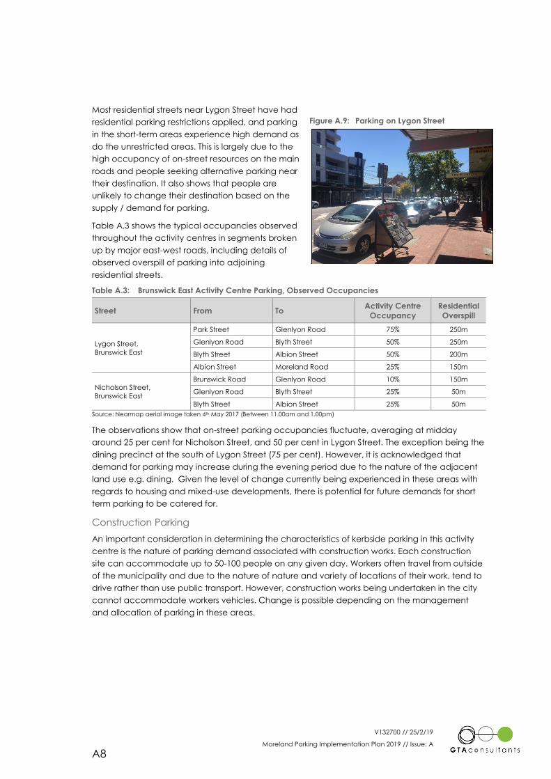
V132700 // 25/2/19
Moreland Parking Implementation Plan 2019 // Issue: A
A8
Most residential streets near Lygon Street have had
residential parking restrictions applied, and parking
in the short-term areas experience high demand as
do the unrestricted areas. This is largely due to the
high occupancy of on-street resources on the main
roads and people seeking alternative parking near
their destination. It also shows that people are
unlikely to change their destination based on the
supply / demand for parking.
Table A.3 shows the typical occupancies observed
throughout the activity centres in segments broken
up by major east-west roads, including details of
observed overspill of parking into adjoining
residential streets.
Table A.3: Brunswick East Activity Centre Parking, Observed Occupancies
Street From To Activity Centre
Occupancy
Residential
Overspill
Lygon Street,
Brunswick East
Park Street Glenlyon Road 75% 250m
Glenlyon Road Blyth Street 50% 250m
Blyth Street Albion Street 50% 200m
Albion Street Moreland Road 25% 150m
Nicholson Street,
Brunswick East
Brunswick Road Glenlyon Road 10% 150m
Glenlyon Road Blyth Street 25% 50m
Blyth Street Albion Street 25% 50m
Source: Nearmap aerial image taken 4th May 2017 (Between 11.00am and 1.00pm)
The observations show that on-street parking occupancies fluctuate, averaging at midday
around 25 per cent for Nicholson Street, and 50 per cent in Lygon Street. The exception being the
dining precinct at the south of Lygon Street (75 per cent). However, it is acknowledged that
demand for parking may increase during the evening period due to the nature of the adjacent
land use e.g. dining. Given the level of change currently being experienced in these areas with
regards to housing and mixed-use developments, there is potential for future demands for short
term parking to be catered for.
Construction Parking
An important consideration in determining the characteristics of kerbside parking in this activity
centre is the nature of parking demand associated with construction works. Each construction
site can accommodate up to 50-100 people on any given day. Workers often travel from outside
of the municipality and due to the nature of nature and variety of locations of their work, tend to
drive rather than use public transport. However, construction works being undertaken in the city
cannot accommodate workers vehicles. Change is possible depending on the management
and allocation of parking in these areas.
Figure A.9: Parking on Lygon Street
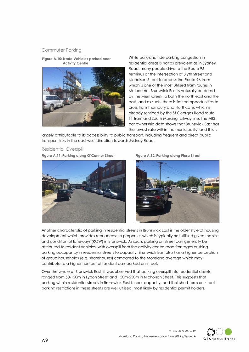
V132700 // 25/2/19
Moreland Parking Implementation Plan 2019 // Issue: A
A9
Commuter Parking
While park-and-ride parking congestion in
residential areas is not as prevalent as in Sydney
Road, many people drive to the Route 96
terminus at the intersection of Blyth Street and
Nicholson Street to access the Route 96 tram
which is one of the most utilised tram routes in
Melbourne. Brunswick East is naturally bordered
by the Merri Creek to both the north east and the
east, and as such, there is limited opportunities to
cross from Thornbury and Northcote, which is
already serviced by the St Georges Road route
11 tram and South Morang railway line. The ABS
car ownership data shows that Brunswick East has
the lowest rate within the municipality, and this is
largely attributable to its accessibility to public transport, including frequent and direct public
transport links in the east-west direction towards Sydney Road.
Residential Overspill
Figure A.11: Parking along O’Connor Street Figure A.12: Parking along Piera Street
Another characteristic of parking in residential streets in Brunswick East is the older style of housing
development which provides rear access to properties which is typically not utilised given the size
and condition of laneways (ROW) in Brunswick. As such, parking on street can generally be
attributed to resident vehicles, with overspill from the activity centre road frontages pushing
parking occupancy in residential streets to capacity. Brunswick East also has a higher perception
of group households (e.g. sharehouses) compared to the Moreland average which may
contribute to a higher number of resident cars parked on-street.
Over the whole of Brunswick East, it was observed that parking overspill into residential streets
ranged from 50-150m in Lygon Street and 150m-250m in Nicholson Street. This suggests that
parking within residential streets in Brunswick East is near capacity, and that short-term on-street
parking restrictions in these streets are well utilised, most likely by residential permit holders.
Figure A.10: Trade Vehicles parked near
Activity Centre
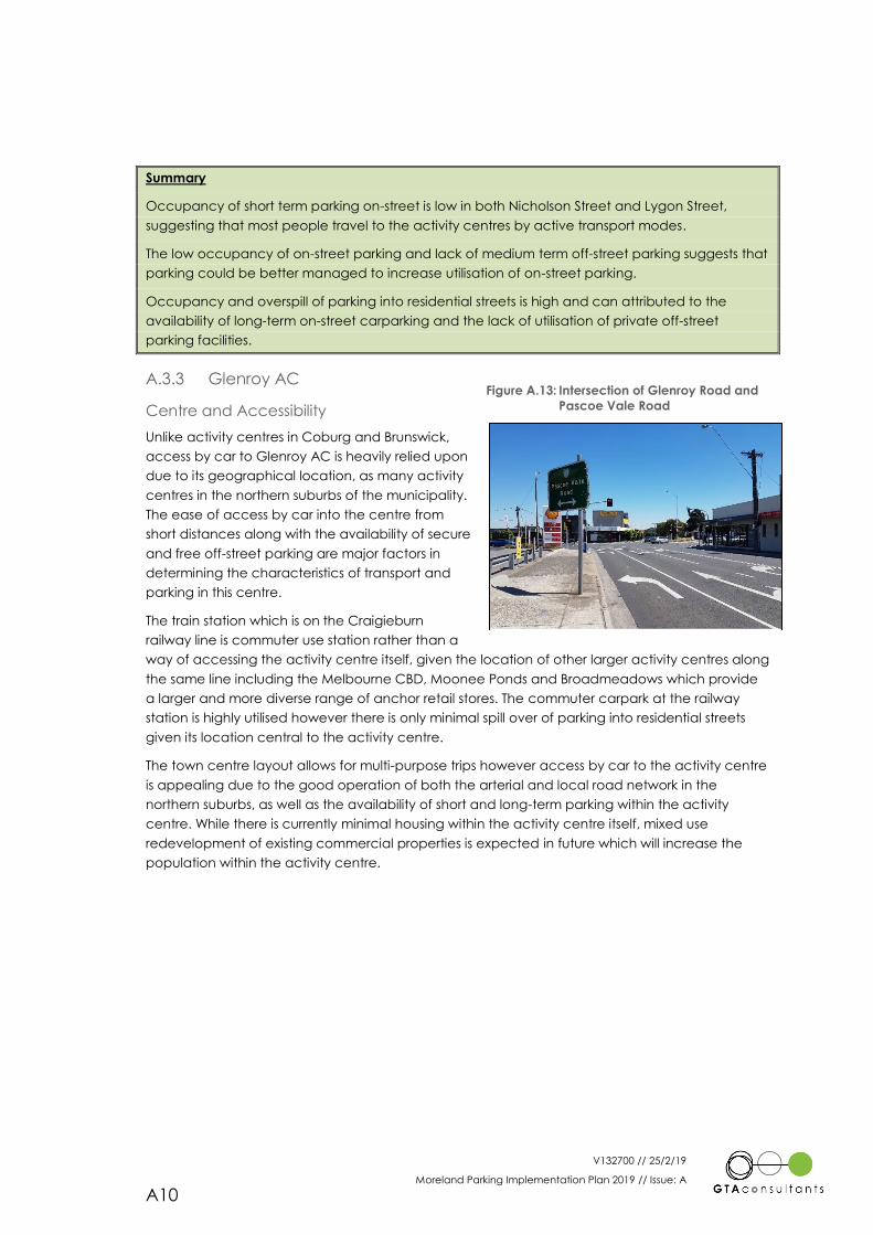
V132700 // 25/2/19
Moreland Parking Implementation Plan 2019 // Issue: A
A10
Summary
Occupancy of short term parking on-street is low in both Nicholson Street and Lygon Street,
suggesting that most people travel to the activity centres by active transport modes.
The low occupancy of on-street parking and lack of medium term off-street parking suggests that
parking could be better managed to increase utilisation of on-street parking.
Occupancy and overspill of parking into residential streets is high and can attributed to the
availability of long-term on-street carparking and the lack of utilisation of private off-street
parking facilities.
A.3.3 Glenroy AC
Centre and Accessibility
Unlike activity centres in Coburg and Brunswick,
access by car to Glenroy AC is heavily relied upon
due to its geographical location, as many activity
centres in the northern suburbs of the municipality.
The ease of access by car into the centre from
short distances along with the availability of secure
and free off-street parking are major factors in
determining the characteristics of transport and
parking in this centre.
The train station which is on the Craigieburn
railway line is commuter use station rather than a
way of accessing the activity centre itself, given the location of other larger activity centres along
the same line including the Melbourne CBD, Moonee Ponds and Broadmeadows which provide
a larger and more diverse range of anchor retail stores. The commuter carpark at the railway
station is highly utilised however there is only minimal spill over of parking into residential streets
given its location central to the activity centre.
The town centre layout allows for multi-purpose trips however access by car to the activity centre
is appealing due to the good operation of both the arterial and local road network in the
northern suburbs, as well as the availability of short and long-term parking within the activity
centre. While there is currently minimal housing within the activity centre itself, mixed use
redevelopment of existing commercial properties is expected in future which will increase the
population within the activity centre.
Figure A.13: Intersection of Glenroy Road and
Pascoe Vale Road
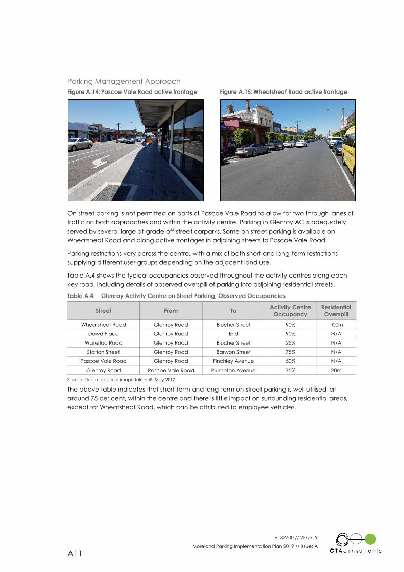
V132700 // 25/2/19
Moreland Parking Implementation Plan 2019 // Issue: A
A11
Parking Management Approach
Figure A.14: Pascoe Vale Road active frontage Figure A.15: Wheatsheaf Road active frontage
On street parking is not permitted on parts of Pascoe Vale Road to allow for two through lanes of
traffic on both approaches and within the activity centre. Parking in Glenroy AC is adequately
served by several large at-grade off-street carparks. Some on street parking is available on
Wheatsheaf Road and along active frontages in adjoining streets to Pascoe Vale Road.
Parking restrictions vary across the centre, with a mix of both short and long-term restrictions
supplying different user groups depending on the adjacent land use.
Table A.4 shows the typical occupancies observed throughout the activity centres along each
key road, including details of observed overspill of parking into adjoining residential streets.
Table A.4: Glenroy Activity Centre on Street Parking, Observed Occupancies
Street From To Activity Centre
Occupancy
Residential
Overspill
Wheatsheaf Road Glenroy Road Blucher Street 90% 100m
Dowd Place Glenroy Road End 90% N/A
Waterloo Road Glenroy Road Blucher Street 25% N/A
Station Street Glenroy Road Barwon Street 75% N/A
Pascoe Vale Road Glenroy Road Finchley Avenue 50% N/A
Glenroy Road Pascoe Vale Road Plumpton Avenue 75% 20m
Source: Nearmap aerial image taken 4th May 2017
The above table indicates that short-term and long-term on-street parking is well utilised, at
around 75 per cent, within the centre and there is little impact on surrounding residential areas,
except for Wheatsheaf Road, which can be attributed to employee vehicles.
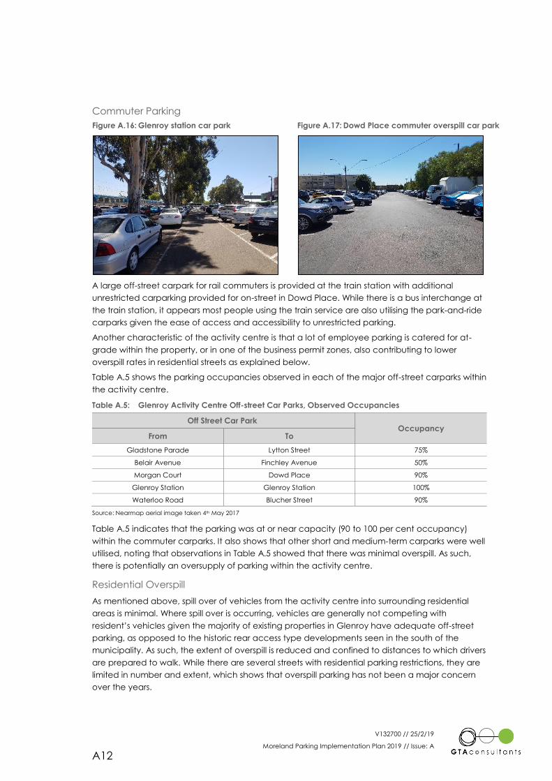
V132700 // 25/2/19
Moreland Parking Implementation Plan 2019 // Issue: A
A12
Commuter Parking
Figure A.16: Glenroy station car park Figure A.17: Dowd Place commuter overspill car park
A large off-street carpark for rail commuters is provided at the train station with additional
unrestricted carparking provided for on-street in Dowd Place. While there is a bus interchange at
the train station, it appears most people using the train service are also utilising the park-and-ride
carparks given the ease of access and accessibility to unrestricted parking.
Another characteristic of the activity centre is that a lot of employee parking is catered for at-
grade within the property, or in one of the business permit zones, also contributing to lower
overspill rates in residential streets as explained below.
Table A.5 shows the parking occupancies observed in each of the major off-street carparks within
the activity centre.
Table A.5: Glenroy Activity Centre Off-street Car Parks, Observed Occupancies
Off Street Car Park Occupancy
From To
Gladstone Parade Lytton Street 75%
Belair Avenue Finchley Avenue 50%
Morgan Court Dowd Place 90%
Glenroy Station Glenroy Station 100%
Waterloo Road Blucher Street 90%
Source: Nearmap aerial image taken 4th May 2017
Table A.5 indicates that the parking was at or near capacity (90 to 100 per cent occupancy)
within the commuter carparks. It also shows that other short and medium-term carparks were well
utilised, noting that observations in Table A.5 showed that there was minimal overspill. As such,
there is potentially an oversupply of parking within the activity centre.
Residential Overspill
As mentioned above, spill over of vehicles from the activity centre into surrounding residential
areas is minimal. Where spill over is occurring, vehicles are generally not competing with
resident’s vehicles given the majority of existing properties in Glenroy have adequate off-street
parking, as opposed to the historic rear access type developments seen in the south of the
municipality. As such, the extent of overspill is reduced and confined to distances to which drivers
are prepared to walk. While there are several streets with residential parking restrictions, they are
limited in number and extent, which shows that overspill parking has not been a major concern
over the years.
V132700 // 25/2/19
Moreland Parking Implementation Plan 2019 // Issue: A
A13
Summary
Long-term off-street parking is highly utilised by commuters and employees and there is
adequate amount for current demand levels as observations show that there is no major overspill
into residential areas.
Future mixed-use developments will increase the demand for parking, pushing the existing
resources to capacity and the transition to active transport modes, especially within the northern
suburbs must be managed to ensure the impacts are minimised during the mode shift
While the activity centre is located around a train station, the ease of access by car and amount
of parking available encourages short car trips.
A.4 Neighbourhood Centres
A.4.1 Overview
As opposed to locations identified in Activity Centres, activity centres identified as
Neighbourhood Centres are much smaller and generally located away from arterial roads,
making it easier for access by short vehicle trips. Given the spacing and location of most
neighbourhood and activity centres within the municipality, it could be expected that some if not
most of the vehicle trips into the activity centres could be supplemented by other modes of
transport.
Of the activity centres in this category, those towards the south of the municipality are
experiencing much higher growth in terms of mixed use development and population growth
than those in the north given the lack of appetite for high density development in the north.
However, this is acknowledged to change as upward pressure continues to be placed on
property prices in the northern suburbs of the municipality.
As per Brunswick and Coburg activity centres, both on-street and off-street controls as managed
similarly from a restriction and allocation perspective where demand is high, provide a consistent
approach for parking management across the municipality. On-street spaces are generally short-
term to encourage turnover while discouraging employee and public transport commuter
parking, enabling access to businesses by customers.
More commonly seen in these activity centres is congestion created both within the activity
centre and in adjoining residential streets by park-and-ride commuters where inadequate supply
is provided for within rail commuter car parks. This is seen mostly in Melville Road, along the route
58 tram and at Oak Park and Pascoe Vale Stations along the Craigieburn Railway Line.
Table A.6 shown below outlines the parking occupancies22 for each of the Neighbourhood
Centres. Further descriptions of each activity centre from a parking and travel demand
management perspective are also provided in the following sections.
22 Parking occupancies were recorded using observations of Nearmap aerial imagery based on a spot count of parked vehicles
along the active frontages within the activity centre and do not account for overspill parking within residential streets. Spot count
observations were undertaken on images taken between 11am-2pm during a standard weekday, not within school or vacation
periods to ensure accuracy.
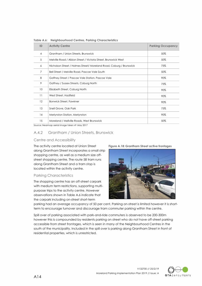
V132700 // 25/2/19
Moreland Parking Implementation Plan 2019 // Issue: A
A14
Table A.6: Neighbourhood Centres, Parking Characteristics
ID Activity Centre Parking Occupancy
4 Grantham / Union Streets, Brunswick 50%
5 Melville Road / Albion Street / Victoria Street, Brunswick West 50%
6 Nicholson Street / Holmes Street/ Moreland Road, Coburg / Brunswick 75%
7 Bell Street / Melville Road, Pascoe Vale South 50%
8 Gaffney Street / Pascoe Vale Station, Pascoe Vale 90%
9 Gaffney / Sussex Streets, Coburg North 75%
10 Elizabeth Street, Coburg North 90%
11 West Street, Hadfield 90%
12 Bonwick Street, Fawkner 90%
13 Snell Grove, Oak Park 75%
14 Merlynston Station, Merlynston 90%
15 Moreland / Mellville Roads, West Brunswick 50%
Source: Nearmap aerial image taken 4th May 2017
A.4.2 Grantham / Union Streets, Brunswick
Centre and Accessibility
The activity centre located at Union Street
along Grantham Street incorporates a small strip
shopping centre, as well as a medium size off-
street shopping centre. The route 58 tram runs
along Grantham Street and a tram stop is
located within the activity centre.
Parking Characteristics
The shopping centre has an off-street carpark
with medium term restrictions, supporting multi-
purpose trips to the activity centre. However
observations shown in Table A.6 indicate that
the carpark including on-street short-term
parking had an average occupancy of 50 per cent. Parking on-street is limited however it is short-
term to encourage turnover and discourage tram commuter parking within the centre.
Spill over of parking associated with park-and-ride commuters is observed to be 200-300m
however this is compounded by residents parking on street who do not have off-street parking
accessible from street frontages, which is seen in many of the Neighbourhood Centres in the
south of the municipality. Included in the spill over is parking along Grantham Street in front of
residential properties, which is unrestricted.
Figure A.18: Grantham Street active frontages
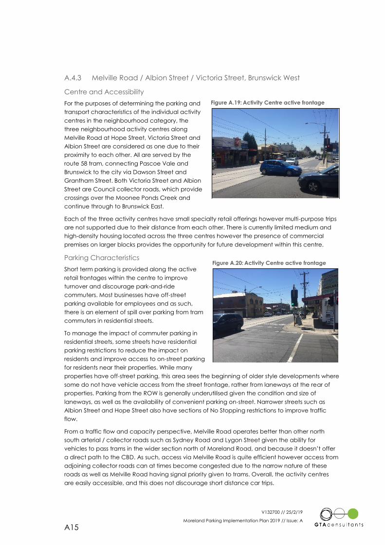
V132700 // 25/2/19
Moreland Parking Implementation Plan 2019 // Issue: A
A15
A.4.3 Melville Road / Albion Street / Victoria Street, Brunswick West
Centre and Accessibility
For the purposes of determining the parking and
transport characteristics of the individual activity
centres in the neighbourhood category, the
three neighbourhood activity centres along
Melville Road at Hope Street, Victoria Street and
Albion Street are considered as one due to their
proximity to each other. All are served by the
route 58 tram, connecting Pascoe Vale and
Brunswick to the city via Dawson Street and
Grantham Street. Both Victoria Street and Albion
Street are Council collector roads, which provide
crossings over the Moonee Ponds Creek and
continue through to Brunswick East.
Each of the three activity centres have small specialty retail offerings however multi-purpose trips
are not supported due to their distance from each other. There is currently limited medium and
high-density housing located across the three centres however the presence of commercial
premises on larger blocks provides the opportunity for future development within this centre.
Parking Characteristics
Short term parking is provided along the active
retail frontages within the centre to improve
turnover and discourage park-and-ride
commuters. Most businesses have off-street
parking available for employees and as such,
there is an element of spill over parking from tram
commuters in residential streets.
To manage the impact of commuter parking in
residential streets, some streets have residential
parking restrictions to reduce the impact on
residents and improve access to on-street parking
for residents near their properties. While many
properties have off-street parking, this area sees the beginning of older style developments where
some do not have vehicle access from the street frontage, rather from laneways at the rear of
properties. Parking from the ROW is generally underutilised given the condition and size of
laneways, as well as the availability of convenient parking on-street. Narrower streets such as
Albion Street and Hope Street also have sections of No Stopping restrictions to improve traffic
flow.
From a traffic flow and capacity perspective, Melville Road operates better than other north
south arterial / collector roads such as Sydney Road and Lygon Street given the ability for
vehicles to pass trams in the wider section north of Moreland Road, and because it doesn’t offer
a direct path to the CBD. As such, access via Melville Road is quite efficient however access from
adjoining collector roads can at times become congested due to the narrow nature of these
roads as well as Melville Road having signal priority given to trams. Overall, the activity centres
are easily accessible, and this does not discourage short distance car trips.
Figure A.19: Activity Centre active frontage
Figure A.20: Activity Centre active frontage
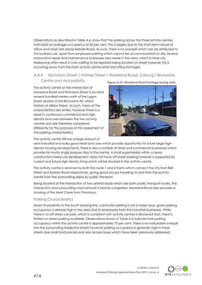
V132700 // 25/2/19
Moreland Parking Implementation Plan 2019 // Issue: A
A16
Observations as described in Table A.6, show that the parking across the three activity centres
indicated an average occupancy of 50 per cent. This is largely due to the short-term nature of
office and retail visits along Melville Road. As such, there is no overspill which can be attributed to
the business use, apart from employee parking which cannot be accommodated on site. Several
automotive repair and maintenance businesses also reside in the area, which in inner city
Melbourne often result in cars waiting to be repaired being located on street however this is
occurring away from the main activity centre retail and office frontages.
A.4.4 Nicholson Street / Holmes Street / Moreland Road, Coburg / Brunswick
Centre and Accessibility
The activity centre at the intersection of
Moreland Road and Nicholson Street is located
several hundred metres north of the Lygon
Street section of the Brunswick AC which
finishes at Albion Street. As such, many of the
characteristics are similar, however there is a
lapse in continuous commercial and high-
density land uses between the two activity
centres and are therefore considered
differently for the purposes of this assessment of
the parking characteristics.
The activity centre still has a large amount of
semi-industrial and bulky good retail land uses which provide opportunity for future large high-
density housing developments. There is also a number of retail and commercial businesses which
provide for mostly single purpose trips to the centre. A small supermarket within a newly
constructed mixed-use development, does not have off-street parking however is supported by
current and future high density living which will be situated in the activity centre.
The activity centre is serviced by both the route 1 and 6 trams which connect the city from Bell
Street and Sydney Road respectively, giving good access travelling to and from the activity
centre from the surrounding areas by public transport.
Being situated at the intersection of two arterial roads which are both public transport routes, the
intersection and surrounding road network is heavily congested. Moreland Road also provides a
crossing of the Merri Creek from Thornbury.
Parking Characteristics
Given its proximity to the South Morang line, commuter parking is not a major issue, given parking
occupancy is already high in the area due to employees from the industrial businesses. While
there is no off-street car park, which is consistent with activity centres in Brunswick East, there is
limited on-street parking available. Observations shown in Table A.6 indicate that parking
occupancy within the activity centre is approximately 75 per cent. There is no noticeable overspill
into the surrounding residential streets however parking occupancy is generally high in these
streets due small land parcels and rear access issues which have been previously addressed.
Figure A.21: Moreland Road frontage facing west
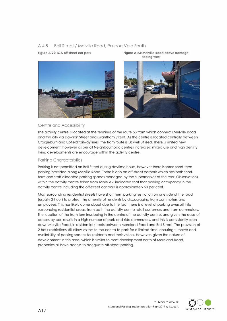
V132700 // 25/2/19
Moreland Parking Implementation Plan 2019 // Issue: A
A17
A.4.5 Bell Street / Melville Road, Pascoe Vale South
Figure A.22: IGA off street car park Figure A.23: Melville Road active frontage,
facing west
Centre and Accessibility
The activity centre is located at the terminus of the route 58 tram which connects Melville Road
and the city via Dawson Street and Grantham Street. As the centre is located centrally between
Craigieburn and Upfield railway lines, the tram route is 58 well utilised. There is limited new
development, however as per all Neighbourhood centres increased mixed use and high density
living developments are encourage within the activity centre.
Parking Characteristics
Parking is not permitted on Bell Street during daytime hours, however there is some short-term
parking provided along Melville Road. There is also an off-street carpark which has both short-
term and staff allocated parking spaces managed by the supermarket at the rear. Observations
within the activity centre taken from Table A.6 indicated that that parking occupancy in the
activity centre including the off-street car park is approximately 50 per cent.
Most surrounding residential streets have short term parking restriction on one side of the road
(usually 2-hour) to protect the amenity of residents by discouraging tram commuters and
employees. This has likely come about due to the fact there is a level of parking overspill into
surrounding residential areas, from both the activity centre retail customers and tram commuters.
The location of the tram terminus being in the centre of the activity centre, and given the ease of
access by car, results in a high number of park-and-ride commuters, and this is consistently seen
down Melville Road, in residential streets between Moreland Road and Bell Street. The provision of
2-hour restrictions still allow visitors to the centre to park for a limited time, ensuring turnover and
availability of parking spaces for residents and their visitors. However, given the nature of
development in this area, which is similar to most development north of Moreland Road,
properties all have access to adequate off-street parking.
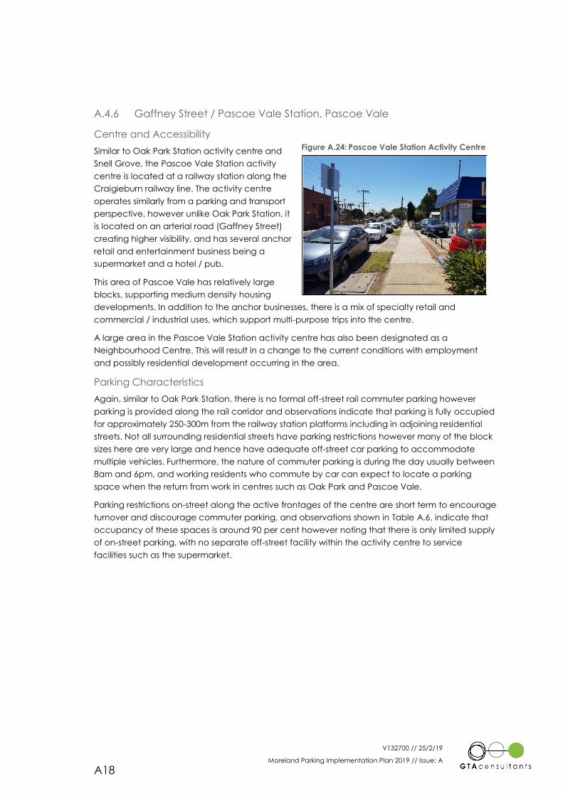
V132700 // 25/2/19
Moreland Parking Implementation Plan 2019 // Issue: A
A18
A.4.6 Gaffney Street / Pascoe Vale Station, Pascoe Vale
Centre and Accessibility
Similar to Oak Park Station activity centre and
Snell Grove, the Pascoe Vale Station activity
centre is located at a railway station along the
Craigieburn railway line. The activity centre
operates similarly from a parking and transport
perspective, however unlike Oak Park Station, it
is located on an arterial road (Gaffney Street)
creating higher visibility, and has several anchor
retail and entertainment business being a
supermarket and a hotel / pub.
This area of Pascoe Vale has relatively large
blocks, supporting medium density housing
developments. In addition to the anchor businesses, there is a mix of specialty retail and
commercial / industrial uses, which support multi-purpose trips into the centre.
A large area in the Pascoe Vale Station activity centre has also been designated as a
Neighbourhood Centre. This will result in a change to the current conditions with employment
and possibly residential development occurring in the area.
Parking Characteristics
Again, similar to Oak Park Station, there is no formal off-street rail commuter parking however
parking is provided along the rail corridor and observations indicate that parking is fully occupied
for approximately 250-300m from the railway station platforms including in adjoining residential
streets. Not all surrounding residential streets have parking restrictions however many of the block
sizes here are very large and hence have adequate off-street car parking to accommodate
multiple vehicles. Furthermore, the nature of commuter parking is during the day usually between
8am and 6pm, and working residents who commute by car can expect to locate a parking
space when the return from work in centres such as Oak Park and Pascoe Vale.
Parking restrictions on-street along the active frontages of the centre are short term to encourage
turnover and discourage commuter parking, and observations shown in Table A.6, indicate that
occupancy of these spaces is around 90 per cent however noting that there is only limited supply
of on-street parking, with no separate off-street facility within the activity centre to service
facilities such as the supermarket.
Figure A.24: Pascoe Vale Station Activity Centre
V132700 // 25/2/19
Moreland Parking Implementation Plan 2019 // Issue: A
A19
A.4.7 Gaffney / Sussex Streets, Coburg North
Centre and Accessibility
The Gaffney / Sussex Street Activity Centre consists of a shopping plaza containing a Coles
shopping centre and other assorted small-scale retail. It has a large parking lot to service the
supermarket accessible via both Gaffney Street and Sussex Street. The south-west corner of the
activity centre is occupied by a skewed roundabout.
Development is occurring adjacent to the site on Sussex street in a residential growth zone. This
predominantly consists of residential subdivisions of the larger scale lots that are present
Parking Characteristics
Parking in the activity centre is predominantly taken up by the off-street car park servicing the
retail shopping. This car park is approximately 8,500 sqm and has a three hour parking restriction.
On street parking is unrestricted in the surrounding area around the activity centre, however due
to the abundance of car parking present, and the three hour restrictions enforced it is not
expected that parking will overflow into the surrounding residential streets.
A.4.8 Elizabeth Street, Coburg North
Centre and Accessibility
Similar to the Gaffney / Sussex Street activity centre, the Elizabeth street activity centre
predominantly consists of an off-street carpark servicing a major supermarket, with minor retail
located nearby. This activity centre is enclosed by Elizabeth Street, Snapshot Drive and Focus
Drive.
The activity centre is located in the Coburg Hill development area. The development area is
currently completed, with many medium density lots constructed as a part of the subdivision.
Parking Characteristics
The car park for this activity centre is split into an off-street car park accessible via Elizabeth Street
and Focus Drive, with further parking located down a ramp to a basement.
On-street car parking around the activity centre is generally unrestricted, and it appears that spill
over into the surrounding streets is occurring. In its current format, this spill over does appear to be
minor, predominantly occurring on the frontages of the shopping area.
A minor supply of strip shopping is present on the eastern side of Elizabeth Street. Frontage on-
street car parking is restricted and appears to be well utilised.
V132700 // 25/2/19
Moreland Parking Implementation Plan 2019 // Issue: A
A20
A.4.9 West Street, Hadfield
Centre and Accessibility
The West Street activity centre consists of strip shopping tenancies along West Street, accessible
via a service road along its frontage. The service road is accessible via a number of points and
travels in the southern direction.
A Woolworths shopping centre is present to the north of the site with a dedicated off-street car
park. This is accessible via Geum Street.
The areas surrounding the commercial precinct are zoned for residential growth. Whilst a number
of properties have been subdivided in the area, this growth is yet to significantly impact the
surrounding residents.
Parking Characteristics
As stated above, the majority of the car parking facilities for the site are accessed via a one-way
service road along the frontage of the strip shops. These car parking spaces are generally time
restricted to two hours. A large, off-street carpark also exists to the north of the activity centre,
primarily servicing the Woolworths. This car park has 1.5 hour parking restrictions which are
enforced by Council under a parking agreement.
Parking restrictions exist in the surrounding residential streets, preventing long stay car parking. This
is likely to protect the amenity of the residents, as the parking along the shop frontages is limited.
Table A.6 indicates that the parking area is nearing its capacity and the residential restrictions
have been put in place to control the retail car parking that the activity centre is attracting.
A.4.10 Bonwick Street, Fawkner
Centre and Accessibility
The Bonwick Street activity centre is primarily grouped around the intersection of Jukes Road and
Bonwick Street in Fawkner. It is a short walk from Gowrie Station on the Craigieburn line. The
surrounding residential areas of the activity centre are located in a residential growth zone, and
some subdivision has accordingly occurred, however this is yet to significantly impact the area.
Parking Characteristics
The Bonwick Street activity centre has a variety of parking types. The main commercial frontage
of the site is occupied by angled on-street car parking. The parking along these frontages is time
restricted and heavily utilised.
Other off-street parking areas exist on the east and west of the centre which are not time
restricted. These car parks are accessible via Jukes Road, McDougall Street and Co-Op Lane.
Despite the high occupancy of the activity centre indicated in Table A.6, there are little on-street
car parking restrictions enforced on the surrounding residential streets. Inspections of this area
indicate that while the car parking in the activity centre itself is highly utilised, it has yet to spill
over into the residential streets. Residential parking to the west of the site, between the centre
and Gowrie Station is also generally at a low occupancy, indicating that commuter car parking is
unlikely to be impacting the activity centre.
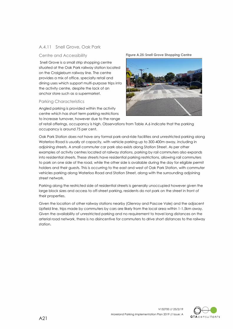
V132700 // 25/2/19
Moreland Parking Implementation Plan 2019 // Issue: A
A21
A.4.11 Snell Grove, Oak Park
Centre and Accessibility
Snell Grove is a small strip shopping centre
situated at the Oak Park railway station located
on the Craigieburn railway line. The centre
provides a mix of office, specialty retail and
dining uses which support multi-purpose trips into
the activity centre, despite the lack of an
anchor store such as a supermarket.
Parking Characteristics
Angled parking is provided within the activity
centre which has short term parking restrictions
to increase turnover, however due to the range
of retail offerings, occupancy is high. Observations from Table A.6 indicate that the parking
occupancy is around 75 per cent.
Oak Park Station does not have any formal park-and-ride facilities and unrestricted parking along
Waterloo Road is usually at capacity, with vehicle parking up to 300-400m away, including in
adjoining streets. A small commuter car park also exists along Station Street. As per other
examples of activity centres located at railway stations, parking by rail commuters also expands
into residential streets. These streets have residential parking restrictions, allowing rail commuters
to park on one side of the road, while the other side is available during the day for eligible permit
holders and their guests. This is occurring to the east and west of Oak Park Station, with commuter
vehicles parking along Waterloo Road and Station Street, along with the surrounding adjoining
street network.
Parking along the restricted side of residential streets is generally unoccupied however given the
large block sizes and access to off-street parking, residents do not park on the street in front of
their properties.
Given the location of other railway stations nearby (Glenroy and Pascoe Vale) and the adjacent
Upfield line, trips made by commuters by cars are likely from the local area within 1-1.5km away.
Given the availability of unrestricted parking and no requirement to travel long distances on the
arterial road network, there is no disincentive for commuters to drive short distances to the railway
station.
Figure A.25: Snell Grove Shopping Centre
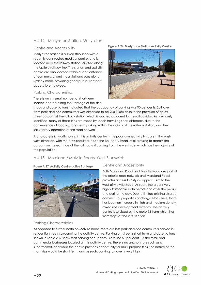
V132700 // 25/2/19
Moreland Parking Implementation Plan 2019 // Issue: A
A22
A.4.12 Merlynston Station, Merlynston
Centre and Accessibility
Merlynston Station is a small strip shop with a
recently constructed medical centre, and is
located near the railway station situated along
the Upfield railway line. The station and activity
centre are also located within a short distance
of commercial and industrial land uses along
Sydney Road, providing good public transport
access to employees.
Parking Characteristics
There is only a small number of short-term
spaces located along the frontage of the strip
shops and observations indicated that the occupancy of parking was 90 per cents. Spill over
from park-and-ride commuters was observed to be 200-300m despite the provision of an off-
street carpark at the railway station which is located adjacent to the rail corridor. As previously
identified, many of these trips are made by locals travelling short distances, due to the
convenience of locating long-term parking within the vicinity of the railway station, and the
satisfactory operation of the road network.
A characteristic worth noting in this activity centre is the poor connectivity for cars in the east-
west direction, with motorists required to use the Boundary Road level crossing to access the
carpark on the east side of the rail tracks if coming from the west side, which has the majority of
the population.
A.4.13 Moreland / Melville Roads, West Brunswick
Centre and Accessibility
Both Moreland Road and Melville Road are part of
the arterial road network and Moreland Road
provides access to Citylink approx. 1km to the
west of Melville Road. As such, the area is very
highly trafficable both before and after the peaks
and during the day. Due to limited existing disused
commercial properties and large block sizes, there
has been an increase in high and medium density
mixed use development recently. The activity
centre is serviced by the route 58 tram which has
tram stops at the intersection.
Parking Characteristics
As opposed to further north on Melville Road, there are less park-and-ride commuters parked in
residential streets surrounding the activity centre. Parking on-street is short term and observations
shown in Table A.6, show that parking occupancy is around 50 per cent. Of the retail and
commercial businesses located at this activity centre, there is no anchor store such as a
supermarket, and while the centre provides opportunity for multi-purpose trips, the nature of the
most trips would be short term, and as such, parking turnover is very high.
Figure A.27: Activity Centre active frontage
Figure A.26: Merlynston Station Activity Centre
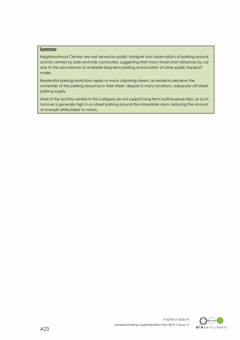
V132700 // 25/2/19
Moreland Parking Implementation Plan 2019 // Issue: A
A23
Summary
Neighbourhood Centres are well served by public transport and observations of parking around
activity centres by park-and-ride commuters, suggesting that many travel short distances by car
due to the abundance of available long-term parking and location of other public transport
nodes.
Residential parking restrictions apply to many adjoining streets, as residents perceive the
ownership of the parking resources in their street, despite in many locations, adequate off-street
parking supply.
Most of the activity centres in this category do not support long term multi-purpose trips, as such,
turnover is generally high in on-street parking around the immediate area, reducing the amount
of overspill attributable to visitors.
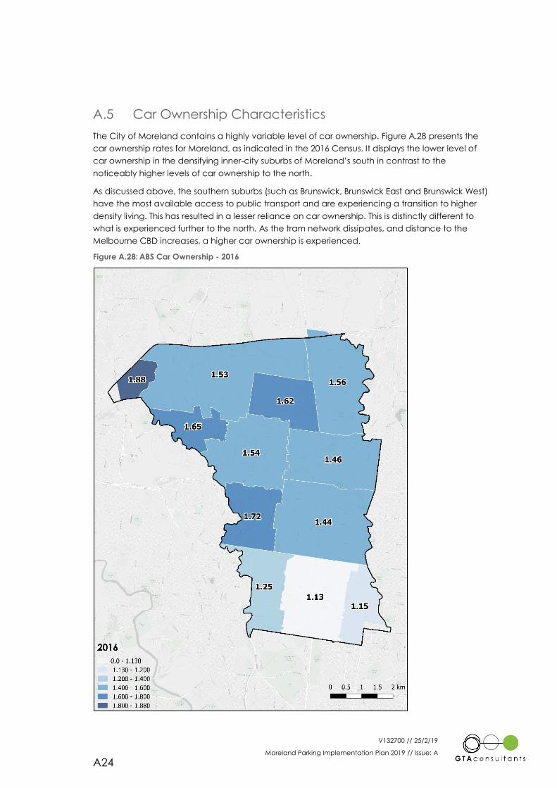
V132700 // 25/2/19
Moreland Parking Implementation Plan 2019 // Issue: A
A24
A.5 Car Ownership Characteristics
The City of Moreland contains a highly variable level of car ownership. Figure A.28 presents the
car ownership rates for Moreland, as indicated in the 2016 Census. It displays the lower level of
car ownership in the densifying inner-city suburbs of Moreland’s south in contrast to the
noticeably higher levels of car ownership to the north.
As discussed above, the southern suburbs (such as Brunswick, Brunswick East and Brunswick West)
have the most available access to public transport and are experiencing a transition to higher
density living. This has resulted in a lesser reliance on car ownership. This is distinctly different to
what is experienced further to the north. As the tram network dissipates, and distance to the
Melbourne CBD increases, a higher car ownership is experienced.
Figure A.28: ABS Car Ownership - 2016
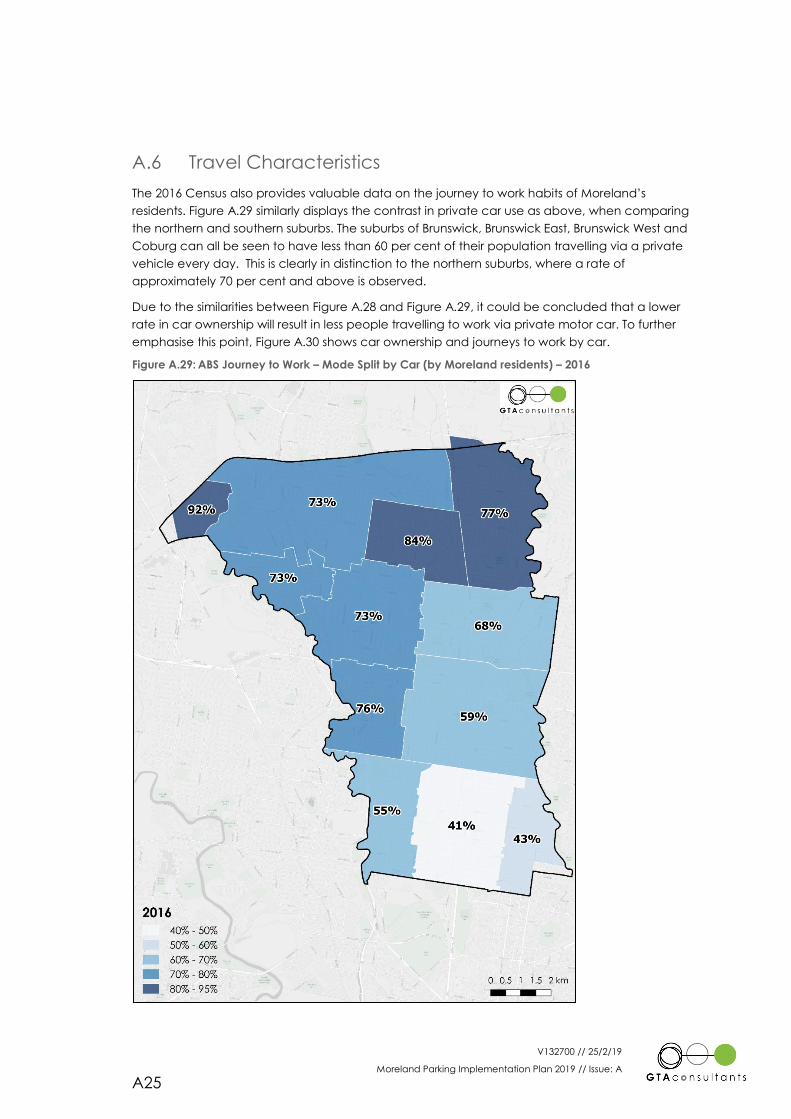
V132700 // 25/2/19
Moreland Parking Implementation Plan 2019 // Issue: A
A25
A.6 Travel Characteristics
The 2016 Census also provides valuable data on the journey to work habits of Moreland’s
residents. Figure A.29 similarly displays the contrast in private car use as above, when comparing
the northern and southern suburbs. The suburbs of Brunswick, Brunswick East, Brunswick West and
Coburg can all be seen to have less than 60 per cent of their population travelling via a private
vehicle every day. This is clearly in distinction to the northern suburbs, where a rate of
approximately 70 per cent and above is observed.
Due to the similarities between Figure A.28 and Figure A.29, it could be concluded that a lower
rate in car ownership will result in less people travelling to work via private motor car. To further
emphasise this point, Figure A.30 shows car ownership and journeys to work by car.
Figure A.29: ABS Journey to Work – Mode Split by Car (by Moreland residents) – 2016
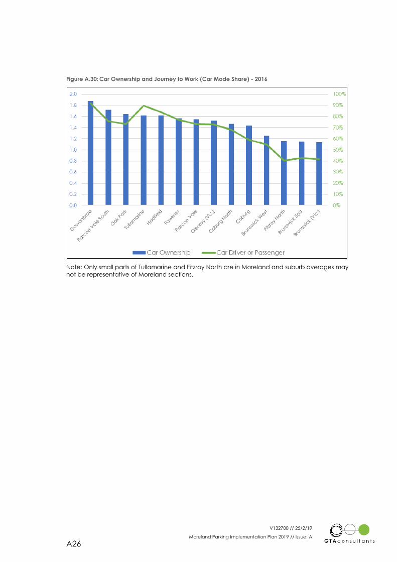
V132700 // 25/2/19
Moreland Parking Implementation Plan 2019 // Issue: A
A26
Figure A.30: Car Ownership and Journey to Work (Car Mode Share) - 2016
Note: Only small parts of Tullamarine and Fitzroy North are in Moreland and suburb averages may
not be representative of Moreland sections.
V132700 // 25/2/19
Moreland Parking Implementation Plan 2019 // Issue: A
A27
Parking Rate Approaches
Ap
pe
nd
ix B
V132700 // 25/2/19
Moreland Parking Implementation Plan 2019 // Issue: A
A28
This Appendix reviews the existing planning scheme in relation to car parking and provides a
summary of car parking approaches adopted by surrounding municipalities.
B.1 Existing Policy
Clause 45.09 of the Moreland Planning Scheme applies parking overlays to land uses in the
Mixed-Use Zone, Residential Growth Zone, Commercial 1 Zone, Commercial 2 Zone and Activity
Centre Zone within the City of Moreland. This overlay applies the Column B parking rates outlined
in Clause 52.06 of the Moreland Planning Scheme.
Column B parking rates outline a lesser requirement than the standard rates shown in Column A.
The rates that are outlined in Column A are the standard which is applied to the whole
municipality.
The Column B rates could be considered to typically reflect ‘Activity Centre’ type rates, which
begin to account for the sharing of car parking between multiple uses during the peak
(weekday, midday) time of the activity centre. An example of the difference between Column A
and Column B rates are that a residential development (such as the construction of a set of
apartments) must provide a space for visitors to park in for every 5 dwellings under the Column A
rates. This is not required under Column B.
The car parking rates for both Column A and B are listed within the state-wide Clauses of the
Victorian Planning Provisions.
While these Column B rates are more appropriate to be applied to activity centres, they are not
tailored to the individual transport availability and land use characteristics of each specific
Activity Centre. There are many Activity Centres throughout Melbourne that have these rates
applied to them, such as in Hawthorn, Kew, Footscray and Heidelberg.
They do not reflect the specific transport availability in the area, such as the amount of public
transport, quality of active travel facilities, amount of existing parking etc.
It should be noted that there are many circumstances in which the rates advised under the
planning scheme are not applied. Each development is assessed individually, and if it is deemed
appropriate to apply a lesser rate, then Council will approve them. Some developments are
being approved throughout Melbourne with close to no parking provided on site, if it is deemed
to be appropriate and acceptable outcome.
In a diverse municipality such as Moreland, with accessibility levels varying across activity centres
more specific consideration of the applied car parking rates is required, particularly if these are to
inform and achieve the mode shift aims of the Moreland Integrated Transport Strategy.
B.2 Car Parking Benchmarking
B.2.1 Parking Overlays
As a means to inform how parking associated with new development within Moreland could be
managed, it is relevant to observe approaches adopted by other similar municipalities within
Metropolitan Melbourne.
This provides some guidance on the appetite of other similar areas to use parking as a tool to
seek mode shift and influence overall transport outcomes.
However, by no means does this limit the approach that could be adopted by Moreland in
managing car parking and potentially may point to the need for other municipalities to further
V132700 // 25/2/19
Moreland Parking Implementation Plan 2019 // Issue: A
A29
review parking management approaches to ensure that parking is an integrated component of
the transport systems rather than driving many of our end transport outcomes due to its rigid
minimum provision requirements.
In this regard the surrounding and similar inner Melbourne municipalities and the extent to which
specific formal statutory parking management approaches have been adopted are as follows:
Darebin: No adopted parking overlay
Moonee Valley: No adopted parking overlay
Maribyrnong:
Footscray – Inner (2015)
Footscray – Outer (2015
Yarra:
Collingwood Arts Precinct (2017)
Stonnington: No adopted parking overlay
Boroondara:
Activity Centres (2013)
Banyule
Greensborough (2013)
Heidelberg Precinct Core (2017)
Bell St & Heidelberg West Core (2017)
Port Phillip
CCZ Fishermans Bend (2012)
The City of Melbourne was not chosen for this assessment, as it has unique characteristics due to it
being the central city; and has therefore applied unique and strict car parking rates. It would not
be a useful comparison point for this assessment.
To further elaborate on those locations where Parking Overlays have been incorporated within
Clause 45.09 of the Planning Scheme the following Parking Overlay approaches and content
summary have been reproduced as follows:
Footscray – Inner (2015)
Maximum Rates Specific Uses
Minimum Rates Specific Uses
Other Uses Column B
Decision Guidelines
Motorcycle Rates
Footscray – Outer (2015)
Maximum Rates Specific Uses
Minimum Rates Specific Uses
Other Uses Column B
Decision Guidelines
Motorcycle Rates
Collingwood Arts Precinct (2017)
Minimum Rates Specific Uses
Other Uses Column B
V132700 // 25/2/19
Moreland Parking Implementation Plan 2019 // Issue: A
A30
Activity Centres (2013)
Minimum Rates Specific Uses
Other Uses Column B
Greensborough (2013)
Minimum Rates Specific Uses
Other Uses Column B
Decision Guidelines (*Car Park Management Plan)
Heidelberg Precinct Core (2017)
Cash-in-lieu
Minimum Rates Specific Uses
Other Uses Column B
Decision Guidelines (*Green Travel Plan)
Motorcycle Rates
Bell Street & Heidelberg West Core (2017)
Minimum Rates Specific Uses
Other Uses Column B
Decision Guidelines (*Green Travel Plans)
Motorcycle Rates
CCZ Fishermans Bend (2012)
Maximum Rates Specific Uses
Decision Guidelines
Motorcycle Rates
From this review a number of specific observations can be drawn.
Of the nominated neighbouring Municipalities to Moreland, five features in Scheme Car
Parking Overlays. This includes Banyule, Maribyrnong, Boroondara, Yarra and Port Phillip.
From these Municipalities there a total of eight Car Parking Overlays, including three
within Banyule, two within Maribyrnong and one each within Boroondara, Yarra and
Port Phillip.
The Car Parking Overlays were introduced into their respective Planning Schemes
between the years of 2012 to 2017.
Only one Car Parking Overlay for the ‘Heidelberg Precinct Core’ features a Financial
Contribution Requirement (Cash-In-Lieu – noting this excludes residential dwellings).
Only three Car Parking Overlays (Footscray-Inner, Footscray-Outer and Fishermans
Bend) feature maximum car parking rates for specified land uses, and permit is required
to provide more than the maximum number of car spaces required by the rates.
A total of seven Car Parking Overlays (including Footscray-Inner and Footscray-Outer
which feature a rate range), provide car parking rate minimums for specific land uses,
and a permit is required to reduce (including reduce to zero) the minimum number of
car spaces required by the rates. It is noted that some further restrictions do apply within
particular Car Parking Overlays.
With the exception of ‘Fishermans Bend’, all other Car Parking Overlays provide Column
B car parking rates for unspecified land uses.
V132700 // 25/2/19
Moreland Parking Implementation Plan 2019 // Issue: A
A31
Decision Guidelines are provided within all identified Car Parking Overlays with the
exception of ‘Collingwood Arts Precinct (Yarra)’ and ‘Activity Centres (Boroondara)’. It
is noted that all Car Parking Overlays within Banyule require either a Car Parking
Management Plan (for where parking is provided elsewhere than on the site) or the
preparation of a Green Travel Plan.
All Car Parking Overlays provide guidance regarding minimum motorcycle parking rate
requirements.
Advice provided by Councils indicates that due to a number of the Car Parking
Overlays being relatively new, it is difficult at this stage to judge their effectiveness.
In addition to the above, many of the nominated neighbouring Municipalities feature
out-of-Scheme Car Parking Management Strategies. These generally seek a reduction
in the use of private motor vehicles and promote travel by sustainable transport modes.
B.2.2 Other Approaches
As part of this car parking benchmarking review, other key sources have been considered.
The RTANSW ‘Guide to Traffic Generating Developments’ (2002) provides a range of car parking
rates for various land uses based on surveys and research. These rates are typically differentiated
by location (e.g. sub-regional city centre), however are not easily categorised by the type of
activity area which they may be applicable to.
In comparing the RTA rates to those set down within Clause 52.06 of the Victorian Planning
Provisions, it is noted that they are generally lower than both the Column A and Column B
requirements for key land uses.
GTA Consultants also has a database of surveys that have been compiled over many years of
surveying car parking. These surveys have been conducted at varying locations around
Melbourne and Australia for many different land uses, locations and times. The rates that GTA
have found in their database are generally comparable with those in the RTANSW guide.
B.2.3 Previous Moreland Parking Strategy Approaches
Both the Brunswick and Coburg Car Parking Strategies developed by GTA generally seek to
provide a “balanced” approach to managing transport impacts. This being to maintain the
future viability of the Centres whilst also addressing current road network congestion issues by
providing a level of restriction around the provisions of additional car parking required for
development land use proposals. Specifically, the Coburg Car Parking Strategy provided
minimum car parking rates but dependant on precinct and location, whilst the Brunswick Car
Parking Strategy provided both minimum and maximum car parking rates as a range for the
entire study area. These rates were typically lower than the Column B rates adopted municipal
wide.

Melbourne
A Level 25, 55 Collins Street
PO Box 24055
MELBOURNE VIC 3000
P +613 9851 9600
Brisbane
A Ground Floor, 283 Elizabeth Street
BRISBANE QLD 4000
GPO Box 115
BRISBANE QLD 4001
P +617 3113 5000
Adelaide
A Suite 4, Level 1, 136 The Parade
PO Box 3421
NORWOOD SA 5067
P +618 8334 3600
Sydney
A Level 16, 207 Kent Street
SYDNEY NSW 2000
P +612 8448 1800
Canberra
A Level 4, 15 Moore Street
CANBERRA ACT 2600
P +612 6243 4826
Perth
A Level 2, 5 Mill Street
PERTH WA 6000
PO Box 7025, Cloisters Square
PERTH WA 6850
P +618 6169 1000
www.gta.com.au www.gta.com.au