Embed Size (px)
Citation preview

PUBLICATION 2005:70
More Effi cient North-South Communications
in Greater StockholmA Concise Summary
SEPTEMBER 2005

2
Stockholm, September 2005
Yours sincerelyYours sincerely
JoJohan Södermanhan SödermanProject Manager
Stockholm, the capital of Sweden, is situated on a
number of islands where the Baltic Sea meets Lake
Mälaren. In the days when the predominant form
of transportation was by sea, this location was
of great advantage. Today however, it presents an
obstacle for the development of the city and of the
region as a whole. As early as the mid-1900’s a cen-
tral ring road and an outer bypass were planned for
Stockholm. Parts of this ring road – Essingeleden,
Södra Länken and Norra Länken – are already in
place, while a new link west of Stockholm on the
outer bypass is still missing. The most recent link
across Lake Mälaren – Essingeleden – was opened
to traffi c back in 1967. Since then Stockholm has
grown by some 400 000 inhabitants and is expected
to grow by another 600 000 inhabitants in the next
three decades. This is why a new road link is essen-
tial to be able to cope with today’s and tomorrow’s
demand for transportation.
To create a new road link across, or in actual fact
under Lake Mälaren west of Stockholm, is a vast
and controversial project. This explains the great
public interest aroused by the recently prepared
Title: More Effi cient North-South Communications in Greater Stockholm Project manager: Johan Söderman, Swedish Road Administration, Stockholm RegionPublic relations offi cer: Gull-Britt Montalvo, Swedish Road Administration, Stockholm RegionConsultant responsible for the preliminary design plan: Tyréns ABAuthor: Lena Norberg, Norberg Network Anders Markstedt, WSP Sverige AB Ingemar Thörnqvist, Tyréns ABLayout: Tecknar’n i Roslagen Photo: Tyréns / WSP Sverige / Hans Ekestang / MiljöbildDocument designation: Publication 2005:70Publication: September 2005 ISSN: 1401-9612
Forewordpreliminary design plan. To provide the interna-
tional audience with a glimpse of the project, this
“summary of the summary” has been translated
into English.
For those who understand Swedish, all the
documents can be found on our website www.
vv.se/nordsydlig.
So far, the desired dialogue with those con-
cerned has been intensive. At this point in time,
I would appreciate it if this dialogue could be
extended and continued at the international level.
I would therefore be more than pleased if you
would address any questions you might have to
me personally in English, German or French.

3
SummaryPreparing a preliminary design plan is a process in
which various options are examined. Those options
which do not result in a fulfilment of the set objec-
tives, or which are technically, environmentally or
economically unsuitable are ruled out one by one.
Preliminary design plan terms of reference
The terms of reference for the preliminary design
plan were to find the road corridor which best
resolves the following challenges:
to connect the northern and southern parts of the region and to make travel possible between them without additional burden on Stockholmʼs central areasto create a by-pass for long distance trafficto improve the level of service on the Stockholm city access roads to improve the opportunities to create a common working and housing market for the whole region through equal accessibilityto make possible a multicentric urban area to create conditions for development in a rapidly expanding region
The preliminary design plan also examines
whether the objectives can be realised through
means other than road construction.
Earlier investigations
The idea of a north-south road link across the
Saltsjö-Mälaren divide is not new, and can be
found in all regional plans for Stockholm County.
In connection with the Dennis Agreement on a
Stockholm Ring Road at the beginning of the
1990s, different options for an outer bypass were
also investigated. The work went as far as to the
final design plan stage for the stretches between
Kungens Kurva and Bergslagsplan and between
Hjulsta and Häggvik. When the Dennis Agreement
was discontinued in 1997, the financing condi-
tions changed and the final design plans were not
formally adopted.
Transitional rules provided in the new Environ-
mental Code meant that the entire Swedish Road
Administration (SRA) planning process would
have to be applied to projects except for those
where a final design plan had already been adopt-
ed or an environmental impact assessment been
approved by the County Administrative Board.
Hence, when the subject of a north-south link
once again came to the fore, a new planning round
was initiated, beginning with a feasibility study
(2001).

4
S
UM
MA
RY
THE STOCKHOLM BYPASS
THE COMBINATION OPTION
THE ULVSUNDA DIAGONAL
THE ‘DO NOTHING’ OPTION
The preliminary design plan
The preliminary design plan contains three options: the Stock-
holm Bypass, the Ulvsunda Diagonal and the Combination Op-
tion. The “Do Nothing” Option is a reference option.
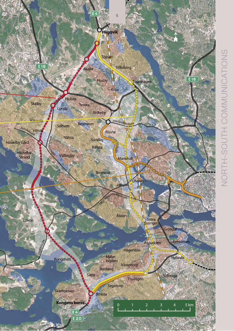
This runs from the E 4/E 20 European Highway at Kungens
Kurva to Häggvik via Sätra, Kungshatt, Lovön, Vinsta, Lunda,
Hjulsta. This route mostly goes through tunnels. At the crossing
over the water at Lambarfjärden between Lovön and Grimsta-
skogen it goes by bridge and runs above ground by Hjulsta.
The Ulvsunda Diagonal runs on the E 4/E 20 European Highway
at Kungens Kurva to Västertorp from where it continues by tun-
nel under Hägerstensåsen and Aspudden/Gröndal and on under
Lake Mälaren, Stora Essingen and Äppelviken to Ulvsunda.
From there it continues for a short stretch above ground, but at
a lower down level through the Ulvsunda industrial area from
which it continues by tunnel to the Kista interchange where it
connects to the E 4. The parts of the E 4 / E 20 which are af-
fected (Kungens Kurva to Västertorp and Kista to Häggvik) will
be widened. There is a connection to Södra Länken at Aspudden.
There are also connections to Enköpingsvägen and Ulvsunda-
vägen north of Solvalla.
The Combination Option comprises road improvements in the
north-south axis Söderleden – Klarastrandsleden – Huvudsta-
leden as well as a new commuter train line Älvsjö – Häggvik and
quality improvements in the public transport system. The Com-
bination Option presupposes road charging, which is intended
to reduce and control road traffi c.
The ‘Do Nothing’ option means that the construction invest-
ments already contained in the regional development plan will
be carried out – with the exception of the Stockholm Bypass or
the Ulvsunda Diagonal. The ‘Do Nothing’ option is not shown on
the map.
5
➸
NO
RT
H-S
OU
TH
CO
MM
UN
ICA
TIO
NS
5

6
In the case of the fi rst two alternatives, a descrip-tion is given of the corridors within which the ultimate alignment of the traffi c route could be positioned. The local impact and impact on the traffi c system within the entire region is also described.
For the Combination Option however, only the regional changes are described. Needless to say, this option will also have a local impact, but the responsibility for the measures and improvements which need to be carried out lies not with the SRA but with municipalities and with the County Coun-cil as the body responsible for public transport.
All the options have been assessed equally as to their potential for fulfi lling the project objectives at the transport system level. The options must
SU
MM
AR
Y
Basic data Stockholm Bypass Ulvsunda Diagonal Combination OptionRoad length,from Kungens Kurva to Häggvik 20.7 km 22.6 km 28.4 km
Length of tunnels 16.0 km 13.6 km 20.0 km*
Length of slip roads 11.3 km 15.0 km –
Number of lanes 6 6 –
Construction cost, at 2003 prices SEK 18-20 billion SEK 17-19 billion SEK 22-32 billion
People travelling in morning rush houracross the Saltsjö – Mälaren divide 112 000 people 112 000 people 108 000 people
Total vehicle mileage 38 million vehicle 38 million vehicle 34 million vehiclein the region 2015 kilometres per day kilometres per day kilometres per day
Total vehicle mileage 3.8 million vehicle 3.7 million vehicle 3.5 million vehicle in the inner city 2015 kilometres per day kilometres per day kilometres per day
all meet present-day environmental and safety requirements, while also considering the conceiv-able requirements of tomorrow. The trend is that environmental issues are being given increasingly greater consideration, while time is becoming more and more precious. Fast and safe underground road systems in combination with environmentally-friendly vehicles should make it possible to meet future requirements.
Hence, a high standard is the ambition for the road construction options. The new road link is designed at motorway standard with three lanes in each direction of travel. The tunnels are housed in two separate tubes with a design speed of 90 km per hour.
After referral for public viewing, one of the three options will be recommended
by the SRA
Once the plan has been referred for public view-ing, all viewpoints have been analysed, and the County Administrative Board has issued its state-ment, the SRA will decide which option to present to the Government for consideration of permis-sibility. Whether this will be the Stockholm Bypass or the Ulvsunda Diagonal, the SRA estimates that construction would be able to commence in 2008 at the earliest and that it will take about 8 years to
complete.
* Including the commuter train tunnel from Älvsjö to Häggvik and the Huvudsta tunnel.

77
The table above summarises how the various options fulfi l the specifi c project objectives (with a ‘yes’ or ‘no’). How they fulfi l the other objectives is assessed in relation to the Do Nothing Option and rated on a 5 grade scale using the following symbols: --, -, =, + and ++. The greatest change for the worse is indicated by “--“ and by “++” for the greatest change for the better. “0” means that the situation is unchanged in relation to the Do Nothing Option.
Note that the various factors have differing weights and cannot be added together.
How do the various options fulfi l the project objectives?
The best option is marked with shading.
Fulfi lment of objective Do Nothing Stockholm Ulvsunda Combination Option Bypass Diagonal Option
Level of Service
Accessibility Yes Yes No
Saltsjö – Mälaren divide Yes Yes No
Central areas Yes Yes Yes
Create a bypass Yes Yes No
City access roads Yes Yes Yes
Regional Structure
Common market Yes Yes No
Multicentrical Yes Yes No
Economic Growth
Conditions for development Yes Yes No
Road Safety
Fewer dead, seriously injured 0 + + ++
Gender Equality
Improvements for women 0 – 0 +
Environment
Health 0 + + +
Safety 0 + + 0/+
Nature, cultural environment, outdoor leisure 0 – – 0 0
Climate targets 0 – – +
Effective use of land and water 0 +/– + +
Ditto, materials and energy 0 – – +/–
Finances
Construction 0 – – – – – –
Operations and maintenance 0 – – – –
Cost benefi t analysis 0 0/+ 0/+ 0/-
8
Corridors and road routes
A preliminary design plan sets out suitable corri-
dors for construction options. The corridor should
be wide enough to enable the best choice of align-
ment in the final design plan. The corridor should
not, however, be unnecessarily wide since the land
within it becomes “blocked” from other use.
A corridor can only be used to describe the gene-
ral effect on the regional transport system, not for
what will happen in the vicinity of the road. For this
reason a road route is placed in the corridor given
in the preliminary design plan. This road route
later serves as the basis for an impact assessment
and as such becomes an example of a possible solu-
tion within the corridor. Any future changes of the
road route as the work progresses will not, how-
ever, change the basics in the proposed solution.
Joint consultation
During the progress of the work, there have been
two major joint consultations: one in the autumn of
2002 and one in the spring of 2003.
The first was arranged at the beginning of the
work on the preliminary design plan when three
possible road corridors from Kungens Kurva in the
south to Häggvik in the north were being examined:
the Stockholm Bypass, Ålstensleden and Bromma-
grenen. The purpose was primarily to get help from
those living within the corridors and other stake-
holders in order to collect all the factors relevant
for continuing work on the preliminary design plan.
The interest and response was enormous, with over
1 300 letters, e-mails and postcards sent in to the
SRA, as well as two petitions: ‘No to Ålstensleden’
and ‘Protect Västerleden’.
By the time the second joint consultation was
carried out, Brommagrenen and Ålstensleden had
been removed from the investigation while a
further option had emerged: the Ulvsunda Diago-
nal. An improvements option, ’Do Nothing Plus’ was
also presented. The aim was then to gather view-
points on the alternative road corridors and their
impact on housing, nature and cultural areas, both
during the construction period and once the road
had been completed. More than 450 written responses
were received at the SRA.
The joint consultation has influenced
the preliminary design plan as
follows:
A Combination Option with expanded public transport services and road charging has been given a more prominent place in the preliminary design plan.
Environmental impact during the construc-tion period has been studied more thoroughly. Construction materials will for the most part be transported through the end tunnel openings to avoid traffic conflicts and disruptions on the local road network.
The Ulvsunda Diagonal Option emerged and afterwards given another connection to the E 4/E 20, where it would be less of a disturbance to those living nearby and at the same time have a better engineering design.
More detailed studies have been conducted on long tunnel sections. Nothing emerged to indicate that it would be less safe to drive in tunnels than on normal motorways.
Two versions of the Lovön Interchange were designed to reflect different assessments of the cultural interest. For the bridge over Lam-barfjärden, two alternatives were presented with heights of 26 metres and 18 metres respectively. On this, the preliminary design plan stated a preference for the higher option.
A special study was conducted on the effects of road charging. The result, together with a study of the effects of increased public trans-port, has been incorporated into the con- siderations.
Information in addition to the consultation
Throughout the course of the work on the
preliminary design plan, meetings have been
held on a continual basis with the County
Administrative Board and the local authorities
concerned. Meetings with those specifically
affected have been arranged on various separate
occasions. The general public was given
information via a mobile bus exhibition in
autumn 2003.
8
S
UM
MA
RY

99
How will the work process continue?
The preliminary design plan will be referred for
public viewing from June to September 2005. The
opinions received will be compiled and commented
on before the County Administrative Board issues
its statement.
During the autumn of 2005 the SRA Stockholm
Region will propose the option it considers most
suited to the purpose. This option will be referred
to the Government for consideration of permis-
sibility. The planning process will then enter into
a new phase and include the fi nal design plan,
construction documents and construction works.
It will not be possible to start construction
before the year 2008. The works are expected to
continue for about 8 years.
The North-South Communications process

Swedish Road AdministrationStockholm Region
SE-171 90 Solna, SwedenStreet address: Sundbybergsvägen 1
www.vv.se [email protected]: +46 (0)771-119 119. Telefax: +46 (0)8-627 09 23. Text telephone: +46 (0)243-750 90