Embed Size (px)
Citation preview

MELBOURNE
WATER
Moonee Ponds Creek Association Incorporated
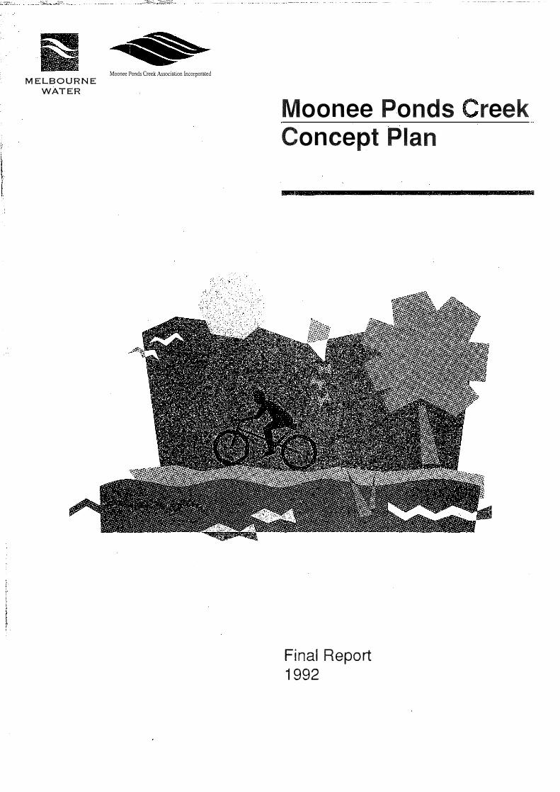
Moonee Ponds reek Concept Plan
Final Report 1992

MELBOURNE
WATER
MOONEE PONDS CREEK CONCEPT PLAN
MOONEE PONDS CREEK CONCEPT PLAN
Prepared by Melbourne Water for Moonee Ponds Creek Association
Bill Johnsen - Project Manager
The project has been funded jointly by Melbourne Water, the Department of Planning
and Housing (Northern Area Improvement Program) through the Moonee Ponds
Creek Association, the municipalities of Melbourne, Essendon, Brunswick, Coburg
and Broadmeadows and Vic Roads.

MOONE£ PONDS CREEK CONCEPT PLAN

MELBOURNE
WATER
MOONEE PONDS CREEK CONCEPT PLAN
Foreword
The Moonee Ponds Creek was once a charming and tranquil recreation area, with an abundance of natural vegetation and wildlife. Later, however, much of the creek was concrete lined and straightened, in conjunction with the construction of the Tullamarine Freeway. As a result of this and other indignities, the creek became a barren eyesore, and its earlier charm was lost.
The Moonee Ponds Creek Association was established in 1989 with a view to realising the true potential of this "Cinderella" among waterways. One of the steps taken by the Association was to secure from the Northern Area Improvement Program $25,000 to assist in the preparation of a Concept Plan for the creek. This acted as a catalyst for financial contributions from the councils adjoining the creek, and from Melbourne Water.
Restoration of the Moonee Ponds Cr.eek is an idea whose time has come. The creek runs from Gellibrand Hill to the Docklands, passing major Melbourne landmarks, and has the potential to be a major Melbourne landmark itself. The creek was originally a series of ponds and wetland areas rather than a continuous watercourse. With appropriate treatments to the concrete lined and straightened areas, we believe the ponds can be put back into the Moonee Ponds Creek,
Kelvin Thomson MLA Member for Pascoe Vale Chairman, Moonee Ponds Creek Association
!
0
3
-

4
MO-ONEE PONDS CREEK CONCEPT PLAN
Overview
Rivers and streams have had major significance in changing the face of the earth over countless millions of years; and for people have become a symbol of life and its continuity.
Even so, we subject our watercourses to major abuses, but because of their linear nature and their continuing capacity to flood their banks and thus restrict the types of use to which their floodplains can be put, rivers frequently represent the last remnants of the natural environment. For many species they are life lines running through our cities.
As such, they serve not only as reminders of the natural systems and past landscapes but are important corridors for the movement of birds and other wildlife. As we become aware of this. there are strong and growing expectations that what remains will not only be preserved, but will be restored as closely as possible.
The Moonee Ponds Creek - its bed, banks and floodplains - has become a drain for our seepage and sewage, with channels to carry flood waters away, leaving private property intact. It has also become a dumping ground for our refuse. If we accept this, we turn our backs on a resource that could add considerably to our city. When we look at the water quality of the Moonee Ponds Creek with dismay, we should consider that this level of water quality reflects the care and responsibility our community has given to the husbanding of the creek's catchment.
Bringing the Moonee Ponds Creek back to something of its original nature, is an essential part of returning all our waterways to their former glory. They were once important wildlife corridors, with a rich and varied vegetation. Many of the species once found along their banks have gone. but the potential is still there to encourage some back. It may be a time consuming task and will require good environmental housekeeping by government departments. councils, business and the community, but the rewards will flow on to the broader community in pleasant parklands and a healthier environment.
The environmental improvement of the Moonee Ponds Creek will best be achieved if the local community has a central role in implementing the changes. Once the benefits of these improvements are realised the whole community - residents. industry and local government - will act as custodian of the creek, ensuring the longterm conservation of this valuable natural resource.
David Lloyd Chairman Concept Plan Steering Committee

MELBOURNE
WATER
MOONEE PONDS CREEK CONCEPT PLAN
Introduction
The Moonee Ponds Creek Concept Plan is now being released as agreed strategic framework for the future development and use of this urban waterway and its environs, so that the total catchment can be managed with a common theme and vision. The Concept Plan describes how the area can be planned and managed to develop the recreational and aesthetic potential without degrading inherent natural and cultural resources. Once approved, this Concept Plan will provide a basis for future development. It forms a guide for the management of the creek and its environs and contains recommendations for implementation.
The plan is part of the Open Space 2000 Program, which aims to create a world-class network of parks, trails, river frontages and beaches for Melbourne - from the Bay to the Ranges.
Preparing the Concept Plan has involved a four stage process.
Stage 1 involved establishing the consultative processes to be adopted for the plan.
In Stage 2, professional research was undertaken into variohls aspects of the creek, and this culminated in a Community Workshop on 25 May 1991, which the results were presented. Armed with this knowledge, the community set a direction and targets for the implementors of the Concept Plan to achieve.
Stage 3 was the development of the plan itself. This required considerable consultation with the community through the Moonee Ponds Creek Association, others and the management authorities, to arrive at an agreed plan.
This plan is now available to the general public after being endorsed by the numerous agencies involved and included in their planning processes and works programs This is the final stage of the Concept Plan, but it is the first stage of making this vision for the creek a reality.
As well as the Concept Plan, numerous resource and background documents were produced as part of the Concept Plan process. These documents include:
•
•
•
•
•
•
"Visual Assessment and Recreation Resources and Opportunities of Moonee Ponds Creek", by Scenic Spectrums Pty Ltd, 1991.
"The Flora and Fauna of Moonee Ponds Creek." by Dale Tonkinson and David Lloyd of Go Green, 1991.
"The History and Heritage of Moonee Ponds Creek.", by Fiona Weaver, 1991 .
"Land Capability Assessment of Moonee Ponds Creek." by Ian Sargeant, 1991 .
"Background Information and Resources Descriptions", May 1991 .
"Alternative Drainage Assessment for Moonee Ponds Creek." by Scenic Spectrums and Neil Craigie and Associates, 1991.
These documents can be obtained from the Moonee Ponds Creek Association, the councils participating, or Melbourne Water.
5

6
-
MOONEE PONDS CREEK CONCEPT PLAN
Acknowledgements
This Concept Plan has been prepared by Bill Johnsen, Senior Project Manager/Parks Division, Open Space Waterways and Environment Directorate, Melbourne Water, for the Moonee Ponds Creek Association; the cities of Broadmeadows, Brunswick, Coburg, Essendon and Melbourne; Vic Roads and the Department of Planning and Housing.
The project was overseen by a steering committee made up of representatives from the agencies involved.
David Lloyd
David Mulholland
John Phillips
Wayne Harvey
Lois Binnie
Jim O'May
Nick Ronan
Phil Lenfhall
Caroline Reddy
Jackie Ross
Mark Waldan and
Josephine Connellan
Kelvin Thomson MLA
Go Green - Chairman of the Steering Committee
Coburg City Council
Melbourne City Council
Broadmeadows City Council
Essendon City Council
Department of Conservation and Environment
Melbourne Water - Yarra Region
Melbourne Water - Maribyrnong Region
Deptartment of Planning and Housing
Vic Roads
Brunswick City Council
Moonee Ponds Creek Association
The assistance of the many other individuals and organisations involved in the preparation of this concept plan is gratefully acknowledged.

MELBOURNE
WATER
MOONEE PONDS CREEK CONCEPT PLAN
The Theme and Vision of Moonee Ponds
Creek
Through workshops, the Moonee Ponds Creek Association and the consultation
process, the community has consistently expressed its desire for a natural creek
environment which incorporates extensive treed areas and a renewal of the creek to
provide a visually attractive flora and fauna habitat. The creek is to be a community
resource, and the link for many uses and is to be managed as a co-ordinated unit.
The targets set by the community have been broadly categorised as follows:
To Revegetate/Conservation
Specific emphasis will be placed on creating a natural environment, removing willows
and box thorns, developing conservation plans, conserving remnant vegetation,
providing weed control, using suitable plants for the conditions in accord with an
indigenous theme. There is a need to balance weed removal with new habitat
development.
To Provide Habitat
Emphasis will be placed on creating a wildlife corridor by rebuilding habitat in the
concrete areas, managing dogs and cats, improving water quality, and providing
lateral links for wildlife to move to other areas.
To Create Wetlands
Emphasis will be placed on specific areas, such as West Melbourne, Jacana and
estuary development in the docklands area. Meanders and habitats will be created,
with a theme of bringing the ponds back to Moonee Ponds and reducing the impact
of the concrete drain.
To Develop Access
Emphasis will be placed on providing better public access to the creek, extending
the linear trail along the entire creek, and developing lateral or cross links to other
areas.
To Ensure Co-ordinated Management
Responsible agencies will coordinate a range of activities from implementing visual
and planning controls and guidelines; co-ordinating land ownership; resolving land
use conflicts; controlling erosionand the use of chemicals; co-ordinating activities,
financial evaluation and encouragement; minimising flood risk, litter, noise and air
pollution.
To Encourage Community Participation
Emphasis will be placed on continuing and increasing community involvement in
revitalising the creek, creating a greater understanding of the environment and
culture of the area, recognising it as an educational and science resource, and
generally developing greater appreciation of the creek and what it has to offer.
7
-
8
MOONEE PONDS CREEK CONCEPT PLAN
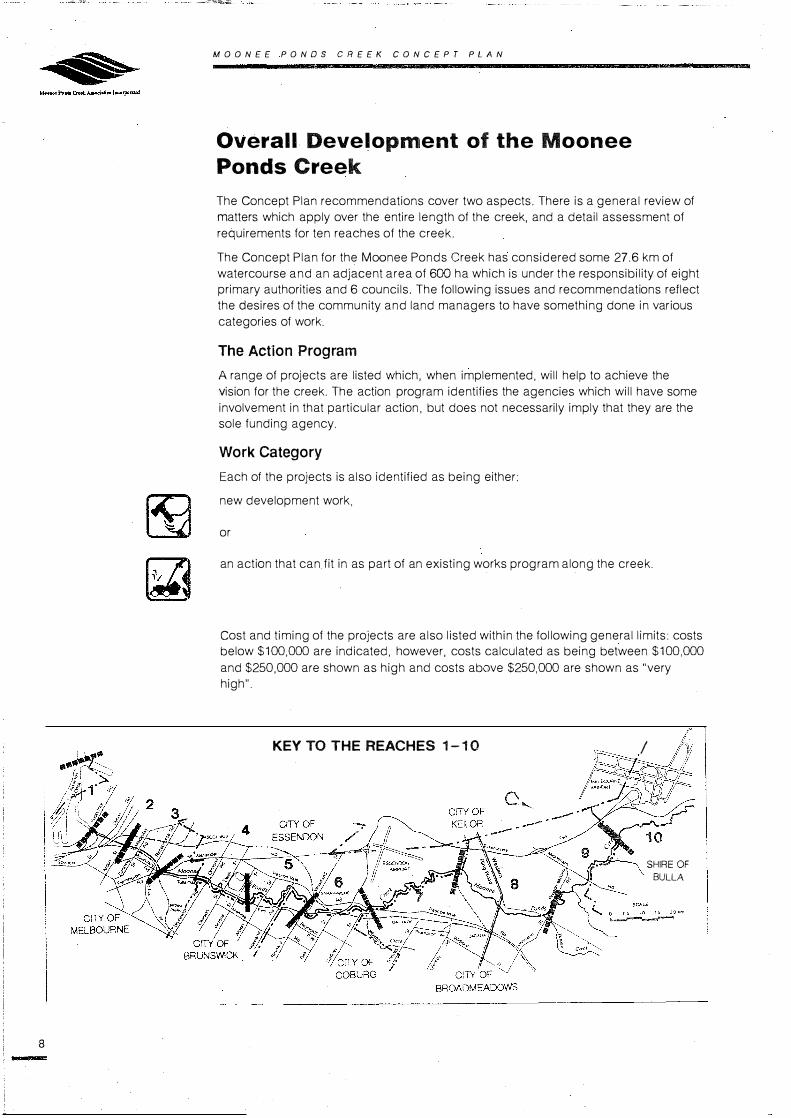
Overall Development of the Moonee
Ponds Creek
The Concept Plan recommendations cover two aspects. There is a general review of
matters which apply over the entire length of the creek, and a detail assessment of
requirements for ten reaches of the creek.
The Concept Plan for the Moonee Ponds Creek has considered some 27.6 km of
watercourse and an adjacent area of 600 ha which is under the responsibility of eight
primary authorities and 6 councils. The following issues and recommendations reflect
the desires of the community and land managers to have something done in various
categories of work.
The Action Program
A range of projects are listed which, when implemented, will help to achieve the
vision for the creek. The action program identifies the agencies which will have some
involvement in that particular action. but does not necessarily imply that they are the
sole funding agency.
Work Category
Each of the projects is also identified as being either:
new development work.
or
an action that can fit in as part of an existing works program along the creek.
Cost and timing of the projects are also listed within the following general limits: costs
below $100,000 are indicated, however, costs calculated as being between $100,000
and $250,000 are shown as high and costs above $250,000 are shown as "very
high".
KEY TO THE REACHES 1-10 I
SHIRE OF
BULLA

MELBOURNE
WATER
�
[!]
�
lGJ
MOONE£ PONDS CREEK CONCEPT PLAN
Timing
The timing of works in the action program are indicated by the following keys:
Short-term action which could start straight away because all resources. approvals
and access are readily available.
Medium-term action, which couid start within the next three years, after the resources,
approvals and access requirements have been arranged.
Long-term action, which will take at least three to five years to obtain the necessary
resources, approvals and access to undertake the work.
Continuing, programmed works are those which will have to be regularly undertaken.
Abbreviations
PTC - Public Transport Corporation
VAS - Victorian Archaelogical Survey
DCE - Department of Conservation and Environment
MPCA - Moonee Ponds Creek Association
PMA - Port of Melbourne Authority
MOET - Ministry of Education and Training
DPH - Department of Planning and Housing
9
-

10
MOONEE PONDS CREEK CONCEPT PLAN
Improvement of the Appearance and
Habitat of the Creek Bed and Banks
There is a strong desire for the development of alternatives to the current drainage
system, which relies on concrete lining of the creek bed. These alternatives have
been shown to be viable, but there is a cost in dollars, land and loss of existing
facilities. The issue is not only to improve the look of the creek, but to develop a
passive recreation resource for people and a habitat for wildlife. Some minor works
and trial works are already underway, but further action will be required to enable the
change to take place over the entire catchment.
Following the work undertaken as part of the Concept Plan, there is a need for a
review of the hydraulic characteristics of the creek, including survey work, to produce
an overall plan for the incorporation of creek revival works. Many of these works could
be incorporated in Melbourne Water's normal maintenance programs as well as future
Open Space 2000 initiative program.
Within each reach implementation of recommendations 1.01, 2.01, 3.03, 4.03,4.04, 5 03, 6.03, 6.04, 6.05, 7.01. 7.02, 7.09, 8.07, 8.13,6.16, 9.03, 10.01 will help to provide the overall improvement of the appearance and habitat of the creek bed and bank.
NATIVE GRASSES & HERBS
NATIVE WOODLANDS & SHRUBS
NATIVE GRASSES
I RIPARIAN REEDS, & HERBS
ESSENDON HOCKEY CENTRE
RUSHES, ETC.
\ IEXISTING CONCRETE
FLOODWAY WITH INVERT
/ t x -���--�
SHARED PATHWAY
NATIVE WOODLANDS & SHRUBS NATIVE WOODLANDS
& SHRUBS
TULLARAMARINE FREEWAY
DAM WALL
ROCK LINING ABOVE CONCRETE BATIERS
ROCK CAPPING ON WEIR WALL
NATIVE GRASSES & HERBS
EXISTING CONCRETE FLOODWAY WITH INVERT

MELBOURNE
WATER
MOONEE PONDS CREEK CONCEPT PLAN
Co-ordinated Management of the Creek
and its Environs
The plethora of management agencies and interests along Moonee Ponds Creek may
lead to a diversity of management practices. There needs to be a formal
co-ordination mechanism and some rationalisation of land management practices.
This would lead to an improvement in the area and savings on maintenance costs.
The viability of having a recognised co�ordinator should be considered. The Moonee
Ponds Creek Association is seen to be a good basis for establishing the formal co
ordination.
Action Program
001
002
003
004
005
Review existing
co-ordination and establish the need for co-ordination.
Involve all agencies
in MPCA
Establish formal co-ordination mechanism under auspices of MPCA.
Implementation of strategies suggested by the review of co-ordination (see 001)
Develop maintenance prescriptions and
standards of style for entire creek through
standing local committee's.
Agency Responsible
MPCA
MPCA
MPCA
Melbourne Water
All
MPCA
Order of Cost $000
$20
$5
$5
$5
$10
Category/ Timing
�
�
�
Within particular reaches, recommendations 4.02, 5.02, 6.02, 7.04 and 10.03 will also develop the required co-ordinated management.
11
-

12
MOONEE PONDS CREEK CONCEPT PLAN
Linear Trail Development
The existing linear trail for the use of pedestrians and cyclists is to be extended and linked. At the moment the trail starts near Delhi Court upstream of Mt Alexander Road and finishes north of Mickleham Road, with a 1.2k m. gap between Primrose Street and Vanberg Road. It is proposed that the trail be constructed to bicycle standard to make it continuous from the Docklands to Gellibrand Hill. There will also be connections to other trails, such as the Maribyrnong and Yarra Trails, the Merri Creek Trail, Royal Park and along the Western Ringroad.
When implemented. recommendations 1.03, 2.03, 3.02, 4.06. 5.09, 9.04. 10.02 and 009 for the various
reaches bf the creek will ensure that the linear trail is continuous.
.....
O 05 10 t.5 20i<rn
---.............r-
LEGEND
Crosslinks to other trails
New trail development
Existing trail

MELBOURNE
WATER
MOONEE PONDS CREEK CONCEPT PLAN
Amenity and Access Improvements to
Land Surrounding the Creek
The creek, generally, has not been treated as a focus for the area. This could now be
changed, especially with some of the waterway improvements proposed. This would
require consideration of the design of some parkland areas so that views and trails
are directed towards the creek, with hindrances to access such as inappropriate
fencing and screen planting, needing to be removed.
Recommendations 3.02, 3.05, 3.03, 4.10, 5.10, 5.11, 6.06, 6.07, 7.10, 7.11, 7.04, 8.05, 8.06, 9.10 and 10.06 within each reach will help to achieve this overall objective.
13
-

14
-
SCALE
I 0
MOONEE PONDS CREEK CONCEPT PLAN
Land Acquisition Program
There are several parcels of land along the creek that are not publicly owned or
accessible. It is proposed that a program of acquisition and securing use be
undertaken to ensure that the public can have unrestricted access over the entire
length of the creek environs. This program would be a major consideration in the
development of the total trail system.
Action Program
2.06 Secure public access between the Docklands and Macaulay Road.
3.06 Acquisition of industrial land along Stubbs Avenue Melbourne.
5.07 Secure public access along the north bank of the creek between Hopetoun Avenue and Moreland Road.
8.14 Acquire industrial buildings downstream of Jacana flood basin.
8. 18 Secure open space use of the Jacana flood basin.
8.17 Acquire land on the west bank downstream of the Jacana flood basin.
9.01 Purchase privately owned Melbourne Water zoned land
C OS 10 IS
..__.--, between Wright and Victoria streets.
9.02 Secure use of Melbourne Water land near Koala Crescent.
10.04 Acquire land along the south side of the Creek - West of Victoria Street.

MELBOURNE
WATER
MOONEE PONDS CREEK CONCEPT PLAN
Planning Controls, Land Use and Zoning
Rationalisation
The whole thrust of planning controls, land usage, zoning rationalisation and building regulations along the creek will be to turn the focus onto the creek. In the past, the community has turned its back to the creek and adjacent parkland, but with a slight change in emphasis and a realisation by the authorities and th€ community, a whole new dimension in improved amenity and lifestyle can be achieved.
At the moment there is a range of zonings along the creek. These should be updated with visual planning controls introduced where they are required to protect or enhance some visual amenity of the creek.
To ensure the focus of the authorities is on the open space development of the creek, each council and agency will the asked to adopt a policy of incorporating the visions of the Concept Plan into all tlleir activities along tile creek.
// i/
/(POS1( . . /\
.·. \,
./ \\/,/ \\ \\
POS
When implemented recommendations 1.05, 3.04, 4.09, 5.05, 5.08 6. 11, 8.02, 9.11 and 10.05 contained
within the reaches, will assist in making this change in attitude achievable.
15
-

16
-
MOONEE PONDS CREEK CONCEPT PLAN
Development of Education and
Information Programs along the Moonee
Ponds Creek
It has been identified that there is a desire by schools and others for an education
and information program focused on the Moonee Ponds Creek. This is an activity that
could be consistent with the roles of the management co-ordinator or as an
independent co-ordinator attached to the Ministry of Education and Training.
Alternatively, Melbourne Water has significant capabilities in this regard which are to
be further strengthened.
Action Program
006 Approach the Ministry of Education and Training to elicit its involvement under auspices of MPCA.
007 Appoint co-ordinator.
008 Develop School and Information Programs.
009 Install information, direction and interpretation signs along entire creek.
010 Provide specific interpretation points along the creek to highlight natural and cultural features.
Agency Responsible
MPCA
MPCA
MPCA MOET
Melbourne Water Councils.
Melbourne Water Councils.
Order of Cost $000
$0
$0
$25
$50
$50
Category/ Timing
��
��
�
��

MELBOURNE
WATER
MOONEE PONDS CREEK CONCEPT PLAN
Continuing Community Participation
The community has shown that it wishes to be involved in the revitalisation of the Moonee Ponds Creek and this will therefore be a continuing feature of the
redevelopment. The Moonee Ponds Creek Association is seen as a focus for this and
will act as the co-ordinator and instigator of many of the activities.
Agency Order of Cost Category/ Action Program Responsible $000 Tl ming
011 Develop the Association MPCA $5 (�l� as an Identifiable community contact
�point.
012 Involve consultation in all All 0
specific plans.
013 Develop stronger links MPCA 0 ��with other groups.
��014 Publish quarterly MPCA $5
news sheet/newsletters Councils and write regular newspaper columns ..
�015 Refer all plans and proposals MPCA 0
for works along the creek to the MPCA
Legend for Reaches Plans
-- Concept Plan Area Boundary
---- Existing Trail
• • • • • Proposed Trail
Watercourse
Plantings
17
............
18
-
MOONEE PONDS CREEK CONCEPT PLAN
Details of the Reaches of the Moonee
Ponds Creek
The creek has been divided into ten reaches and the issues, development options
and action programs for each are detailed on the following pages.
Reach 1 : Docklands - from the Yarra River to
New Footscray Road
Length considered: 1.5 km
Area Involved: 36+ ha
Municipality: Melbourne
Ownership: land vested in the Port of Melbourne Authority
Relevant Authority - Docklands Authority, PMA
Description
A tidal unused piece of land.
Issues
• Proposed developments in association with Docklands and Victorian Ports
Land Use study could substantially affect the preferred option. In particular the
construction of docks: Appleton, F and G.
• Ownership and management of land.
• Western By-pass development. The location will have major impact on many
proposals in area.
• Possible rail and infrastructure developments in area.
Vision for the Reach
Watercourse
The watercourse should be developed with an estuarine theme. with the west bank
retained as isolated nature area.
Land
Planting and habitat creation. land management, observation points and access
tracks should be subject to future development proposals.
Management
Development and maintenance of area should be co-ordinated.
Social
Public access should be provided along the east bank of the creek.

MELBOURNE
WATER
-·--·-·---·-
MOONEE PONDS CREEK CONG EPT PLAN
Action Program
1.01
1.02
1.03
1.04
1.05
Incorporate concept plan theme into Docklands De I Plan by T
ve opment
the Ports ���ource, and also
se Study.
Rationalise control man
and agement of creek and
open space environs to best achie th
ve the concepteme and cons
saltmarsh veget::� remnant
Shape and - . . prepare ground
1nclud1ng site de plant with suitabl
sign � ande species
Construct paths si interpretation fa�ilitTer:boardwalks and oth facilities.
er
Develop new b 1 . and enhanc
u1 ding controls . e ex1st1ng O
to improve the . nes, so as
areas in the ' visual amenity of
v,c1nity of the creek.
Agency Responsible
DocklandsTaskforce PMA
Melbourne Water PMA
Melbourne Water
MelbourneWater
PMA
Order of Cost $000
$5
$5
$100
$200
$200
$5
Category/ Timing
��
�
��
��
-

20
-
MOONE£ PONDS CREEK CONCEPT PLAN
Reach 2: Railyards - from New Footscray Road
to Arden Street
Length Considered: 1.3 km
Area Involved: 15 ha
Municipality: Melbourne
Description
The creek runs through the midst of railway sidings and is crossed by numerous low bridges. The area .has very sparse vegetation and is visually dominated by surrounding heavy industry.
Issues
.. Safe pedestrian and cycle access to the bay, Yarra and Maribyrnong Rivers must pass through this industrial area.
• Proposed Western By-Pass location.
" Ownership of land and responsibility for the creek.
" Security of PTC assets.
" National Rail Freight Authority interests.
Vision for the Reach
Watercourse
The creek should be cleared and deepened at the centre to enable canoes etc. to pass, and the edges should be planted out with aquatic species to establist, habitat.
Land
Screen planting and fencing should be provided to separate the creek environs from industry and the rail yards. Paths, fishing platforms and boardwalks should be constructed.
Management
Management and maintenance should be co-ordinated between adjoining land managers and creek authorities.
Social
Safe public access should be provided to the creek and its environs.

ii MOO NEE PONDS CREEK CONCEPT PLAN
MELBOURNE
WATER
Agency Order of Cost Category!
Action Program Responsible $000 Timing
2.01 Study possible contamination of Melbourne $20 [)) land along the creek. Water
PTC Vic Roads Melbourne
[)) �/
2.02 Secure the strip of land owned by Melbourne $5
railways and others between Water McCauley Road and the Docklands PTC
to establish a linear link.
[I) 2.03 Arrange appropriate rezoning of Melbourne $10
land in conjunction with other Water necessary rezonings. Vicroads
Melbourne
�2.04 Detail design of trails and Melbourne $10
plantings. Water Melbourne
(G) 2.05 Dredge and clean up creek. Melbourne Very High Water
2.06 Implement a planting program. Melbourne $30 �Water Melbourne PTC
[)) 2.07 Construct trail. Melbourne High Water Melbourne PTC Vicroads
[)) �2.08 Constuct platforms, including Melbourne $30
boat launching and fishing Water platforms. PTC
��2.09 Co-ordinate management. MPCA $5
Melbourne Water PTC Melbourne
2.10 Finalise proposed Western Vicroads $0
By-Pass location.
21
-

22
MOONEE PONDS CREEK CONCEPT PLAN
Reach 3: Macaulay - from Arden Street to
Mt Alexander Road
Length considered:. 1.6 km
Area Involved: 23 ha
Municipality: Melbourne
Description
The creek consists of wide expanses of grass between levee banks with the water
confined to a relatively small channel upstream of Macaulay Road, but as a wide
canal downstream. The immediate surrounding area is industrial in nature, with the
Upfield railway line defining the east bank. The area has a large residential population
concentrated in highrise flats, which provides an incentive to create open space in
this area.
issues
• Flooding is a major consideration in the development of the drainage system,
and controls the type of development possible.
• Negotiations on maximising availability of usable land.
• Provision of open space and recreation opportunity for local residents as well
as forming regional links.
• Location and timing of proposed Western By-pass.
• Co-ordination between authorities.
• Transfer of silt down the creek to this reach.
Vision for the Reach
Watercourse
Complete flood mitigation works in such a way that they encourage recreational use
of the waterway, by improving water quality and litter control, with estuarine planting
in the lower part of the reach and representative planting in the upper part.
Land
The focus of development and activities along the creek should be turned around to
use the open space along the creek and to provide links and access to the
surrounding streets and community. The area should be developed as a linear open
space and recreation corridor, with appropriate planting and facilities.
Management
Co-ordinated management of the creek, with agreed maintenance prescriptions and
funding arrangements should be adopted. Vjsual and planning controls should focus
attention.on the creek and should stop inappropriate development. Total catchment
management arrangements should control silt before it reaches this area.
Social
Social equity for area should be improved by providing proportionally more open
space. People should feel more secure in the area when more people are attracted
there for recreation.

MELBOURNE
WATER
MOONEE PONDS CREEK CONCEPT PLAN
Action Program
3.01 Complete hydraulic investigation of the creek, including development of a silt and litter management program and flood mitigation.
3.02 Develop linear trail access along and across creek, with links to other recreation facilities nearby.
3.03 Improve the amenity of the open space corridor by reshaping the land form, undertaking appropriate , planting and relocating facilities.
3.04 Establish visual controls to enhance the amenity of the area and structures facing onto creek.
3.05 Improve physical and visual access to the creek and surrounding open space.
3.06 Arrange for ultimate acquisition of industrial land along Stubbs Street.
Agency Responsible
Melbourne Water
Melbourne Melbourne Water
Melbourne Water Melbourne
Melbourne Melbourne Water
Melbourne Melbourne Water
Melbourne Melbourne Water
Order of Cost $000
$40
High
$100
$20
$100
High
Category! Timing
23
-

MOONEE PONDS CREEK CONCEPT P�AN
Prepare detailed landscape plan for discre1e areas
Introduce visual and planning controls to eqsure emphasis on creek environment
Review hydraulic requirements of drainage system
Q Construct con:in.uous Jin.ear �trail
f:Wl�legend
Screen plant along obtrusive S1ructures and faci!i!ies
Existing Trail Pror;osed Trail
MELBOURNE:
WATER
MOONEE PONDS CREEK
Major Action Program Initiatives
Involve community in more aspects of creek development
Co-ordinate management along creek
f]i) Undertake planting along creek � to establish habitats
I
(i1
�
�
lmorove main1ainance and weed eradication programs
Develop management 1echniques for erosion control etc.
Aquire land to provide continuous public open space
Enhance cultural features su_cn as historical and aboriginal srtes art potential
� Devefop series of ponds along � creek to create wetlands
MOONEE PONDS CR££K CONCEPT PLAN
fi'l' Develop access to other areas L:!'.J through la1era! trail connections
� Review noise attenuation � method
� Open up parkland by fence - �:�:��;�
1�ther access
� Provide better facil�1es for rn!J :�:u�t:r�:derstanding of
Education Program

26
-
MOONEE PONDS CREEK CONCEPT PLAN
Reach 4: Ormond - from Mt Alexander Road to
Near Evans Street
Length considered: 3.6 km
Area: 46 ha
Municipalities: Melbourne, Essendon, Brunswick
Description
The reach is dominated by the wide expanses of concrete channel and the
Tullamarine Freeway on the east bank. There is an area of well-maintained sports
ovals along the west bank.
Issues
• The dominant visual aspect of the concrete.
• Access for Brunswick residents.
• Impact of the proposed Western By-pass, including any widening of theTullamarine Freeway.
• Continuity of the linear trail.
• Control of flooding and erosion.
• Impact of creek development on the sports grounds.
• Landslips along the creek.
Visions for the Reach
Watercourse
The concrete drain should be converted into a more natural looking creek, but without
affecting flood levels.
Land
The surrounding parkland should be further planted and, along with sports grounds,
should be integrated as a natural creek surround.
The linear trail should be continued and cross links to the east bank should be
developed.
Management
Co-ordination of development management, implementation and maintenance of
parkland should be undertaken where appropriate .
Zoning should be rationalised to suit the existing situation.
Social
Better access to the creek and information about its revitalisation should be provided
for people.

ii MOONEE PONDS CREEK CONCEPT PLAN
MELBOURNE
WATER
Agency Order of Cost Category/
Action Program Responsible $000 Timing
4.01 Prepare detailed landscape Melbourne $50 �plans and documentation Water consistent with the overall Melbourne reach and concept plan vision Brunswick for discrete areas along the Essen don creek.
�4.02 Co-ordinate future Melbourne $10
management responsibilities Water along the creek for this reach. Vic Roads
Melbourne Brunswick Essen don
��4.03 Implement interim Melbourne Medium alternative drainage Water schemes to visually hide the concrete with the ultimate aim of providing complete cover for the concrete in a more natural stream and pond form.
�4.04 Identify land required to Melbourne $5
.
accommodate ultimate Brunswick removal of concrete. Essen don
� �4.05 Plant suitable species Melbourne $100
.
while allowing for the Brunswick ultimate drainage system. Essen don
Melbourne Water
� �406 Extend the linear trail to Melbourne $100
.
pass underneath the Mt Alexander Road Bridge
� �4.07 Construct. small bridges Brunswick $100
across the creek to provide Essen don lateral access.
(I] �4.08 Provide access via the bridge Melbourne Very or other means to Royal Park Vic Roads High and the Merri Creek
� �4.09 Arrange for appropriate Melbourne $10
rezoning of land. Brunswick Essen don
� �4.10 Remove inappropriate Melbourne $10
fencing and install Water safety fencing Melbourne
�where required. Brunswick
Essen don
� �i
4.11 Construct a signage system Melbourne $10
.·
along the .trail. Brunswick Essen don
27
-

MOONE£ PONDS CREEK CONCEPT PLAN M00NEl PCNDS CRf::EK CONC[PT PLAN
28 29

30
MOONEE PONDS CREEK CONCEPT PLAN
Reach 5: Moreland - from Evans Street to
Woodland Street:
Length Considered: 3.75 km
Area Involved: 27 ha
Municipalities: Coburg, Essendon, Brunswick
Description
The creek has been shaped and along half the reach has been concrete lined. It
follows a meandering course in a relatively narrow reserve surrounded by intense
residential development. Nonetheless, the area contains two most attractive
landscape settings. The linear trail is not continuous along the creek, but is located
along residential streets for several kilometres.
Issues
" Continuity of the parkland and the linear trail along the creek.
• Lack of vegetation.
• Aesthetic improvements to the concrete channel.
" Fire risk and emergency access.
Vision for the Reach
Watercourse
The visual impact of the straightened and concrete-lined creek should be minimised
by the construction of a series of ponds. Revegetation and improvement in water
quality and litter control along the creek and its tributaries will be necessary in
creating a wildlife corridor .
Land
Continuity of the creek-side parkland and the linear trail should be established, and
lateral open space links to other parks and trails should be constructed across the
creek in the form of bridges and fords.
Management
Co-ordination of management by the three councils and Melbourne Water should be
developed. Planning and fencing controls and visual guidelines on property adjacent
to the creek should be produced as part of an effort to turn the focus back on the
creek.
Social
Equitable distribution of open space and providing personal security in the
environment should be allowed for in the development.

ii MOO NEE PONDS CREEK CONCEPT PLAN
MELBOURNE
WATER
Agency Order of Cost Category/ Action Program Responsible $000 Timing
5.01 Prepare detailed landscape Melbourne $20
plans and documentation Water consistent with the overall Essen don reach and concept plan vision Coburg for discrete areas along Brunswick the creek.
� �5.02 Co-ordinate future Melbourne $10
management Water responsibilities along the Essen don creek for this reach. Coburg
Brunswick (I] �5.03 Construct a series of ponds. Melbourne High
Water
5.04 Remove weeds and Coburg $100
revegetate. "Essen don Brunswick Community
�-� 5.05 Implement visual ·planning Coburg $10
controls for areas along the Essen don creek to encourage Brunswick painting or screen planting Councils of existing obtrusive
��buildings and structures.
5.06 Implement measures for noise Vic Roads $100
attenuation near the freeway
� �� Acquire private �QZ) Melbourne $10
drainage reserves and Water open space land.
�5.00' Rezone open space . Essen don $10
5.09 Construct linear trail in Melbourne Very (I] �conjunction withMelbourne Water High
�Water maintenance track Essen don and make it continuous. Brunswick
5.10 Construct bridges and Coburg Very (I] �fords across the creek to Brunswick High develop lateral links with Essen don other parklands. Melbourne
Water
�5.11 Develop specific lateral Essen don $50
open space links.
� �5.12 Investigate open space Essen don $10
reserve potential. in some Coburg areas. Brunswick
31
-

32
MOONE£ PONDS CREEK CONCEPT PLAN
Reach 6: Junction - from Woodland Street to
Pascoe Vale Road
Length Considered: 2.5 km
Area Involved: 33 ha
Municipalities: Coburg and Essendon
Description
This reach is dominated by man-made structures such as the road and rail transport
systems, and sections of the creek are gunbarrel straight and concrete lined. The
road junction is overpowering. This reach is one of the least attractive along the
creek, with minimal recreation opportunities and requires particular attention. On the
plus side, this reach also has large areas of unused land with open space potential.
Issues
• Stark appearance of area and dominance of structures.
• Lack of recreation potential.
• Pedestrian access and lateral links.
• Lack of vegetation.
Vision for Reach
Watercourse
Naturalisation of the creek should be undertaken to cover the concrete and to
mitigate the gun barrel appearance by introducing visual meanders by sculpting the
bank and planting vegetation.
Land
Mounding and planting with suitable species should be undertaken to screen some of
the major negative visual aspects. Planting, rendering or artistic treatment of some of
the major concrete structures in the area should also be carried out. There is a
potential for Art in Public Places in the area of the Bell Street Overpass
Management
Management and maintenance should be co-ordinated between the authorities with
responsibilities in this reach.
Social
Public access for all and the provision of personal security and environmental
improvement of under-utilised land should create a better image for entrances to the
cities of Coburg and Essendon.

ii MOONEE PONDS CREEK CONCEPT PLAN
MELBOURNE
WATER
Agency Order of Cost Category/ Action Program Responsible $000 Timing
6.0 1 Prepare detailed landscape Melbourne $20 �plans and documentation Water consistent with the overall Coburg reach and concept plan vision Essen don for discrete areas along the
�creek.
6.02 Co-ordinate future Melbourne $10
management Water responsibilities along the Essendon creek for this reach. Coburg
� �6.03 Recontour the creek Melbourne $100
banks. Water
6.0 4 Construct a series of Melbourne $100 [IJ �ponds. Water
6.05 Plant suitable species Melbourne $100 � �along the creek and in its Water environs. Essen don
Coburg, Go Green MPCA.
� �6.06 Screen major facilities, Essen don $50
.
where possible, with Coburg plantings. Vic Roads
MPCA/PTC
[IJ �6.07 Improve the appearance of Vic Roads $20
structures. PTC
� �608 Investigate noise alleviation Vic Roads $10
potential.
6.09 Remove and replace Melbourne $20 � �fences, where possible. Water
Coburg Essendon
[IJ �6.10 Construct fords for Melbourne $50
lateral links, and assess Water existing bridges. Coburg
Essen don
[IJ �6.11 Develop planning controls, Coburg $10
where required, along the creek.
�6.12 Develop lateral links Coburg $20
between Moonee Ponds and the Merri Creek.
� �6.13 Develop a lateral link from Coburg $20
Kelvin Thomson Park to PTC Strathmore High School. Vic Roads
�614 Develop Art in Public Melbourne $20
.
Places projects. Water Vic Roads Councils
33
-

MOONEE PONDS CREEK CONCEPT PLAN
34
MELBOURNE
WATER
MOONEE PONDS CREEK CONCEPT PLAN
35
36
-
MOONEE PONDS CREEK CONCEPT PLAN
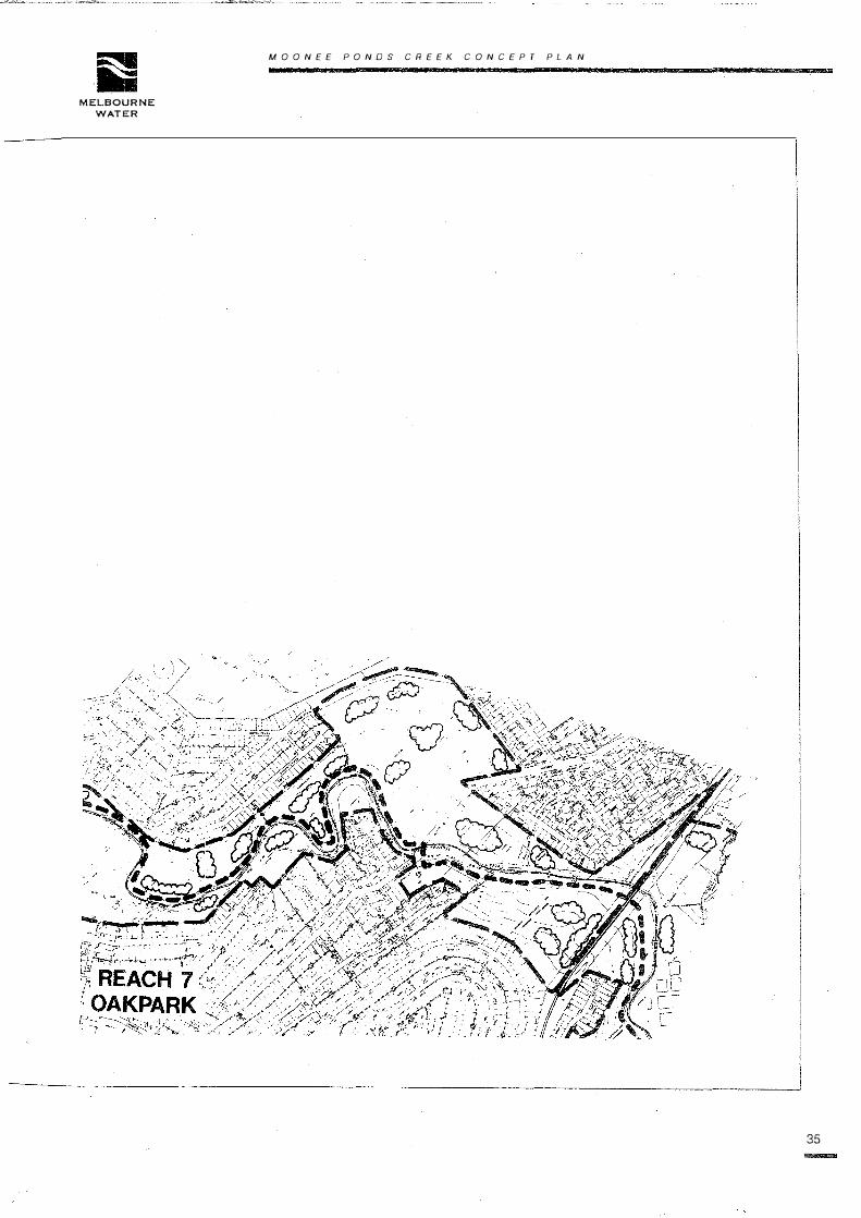
Reach 7: Oak Park - from Pascoe Vale Road to
Trestle Bridge
Length considered: 4.5 km
Area Involved: 90 ha
Municipalities: Essendon and Broadmeadows
Description
This reach is characterised mainly by the extensive sports grounds along the creek.
The valley starts to spread out, and with less residential impact, there is a less
constrained feel to the area of the creek. The creek is concrete lined to near
Strathmore North Primary School, and is unlined, straightened and uniformly shaped
for the remainder of the reach. The linear trail is continuous through this reach.
Issues
• The visual amenity of sporting facilities in the vicinity of the creek.
• The proximity of Essendon Airport and the flight path.
• Undeveloped open space.
• The location of Broadmeadows nursery within Essendon.
Visions for the Reach
Watercourse
Re-creation of meanders and ponds is considered desirable, and suitable aquatic
and riparian species should be planted to provide shade and habitat.
Land
Future development beside the creek should focus on it.
Suitable species should be planted in broad areas to provide habitat and shade.
Open-space links to Essendon Airport land should be preserved.
Unique species of trees within the Broadmeadows nursery should be retained.
The amenity of the area should be improved by reducing advertising etc.
Management
Management of the sports areas and other facilities should be co-ordinated.
Social
Equitable access should be possible for all.
The amenity of the area should be enhanced.
Vandalism should be reduced.
ii MOO NEE PONDS CREEK CONCEPT PLAN
MELBOURNE
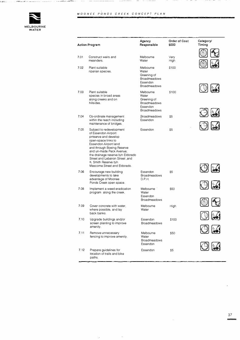
WATER
Agency Order of Cost Category/
Action Program Responsible $000 Timing
7.01 Construct weirs and Melbourne Very [I] �meanders. Water High
[I]� 7.02 Plant suitable Melbourne $100
riparian species. Water Greening of Broadmeadows Essen don Broadmeadows
� i';
7.03 Plant suitable Melbourne $100
species in broad areas Water along creeks and on Greening of hillsides. Broadmeadows
Essen don Broadmeadows
7.04 Co-ordinate management Sroadmeadows $5
within the reach including Essen don maintenance of bridges.
� :i,
7.05 Subject to redevel_opment Essen don $5
of Essendon Airport: preserve and develop open-space links to Essendon Airport land and through Boeing Reserve and un-made Peck Avenue; the drainage reserve b/n Eldorado Street and Lebanon Street ,and K. Smith Reserve b/n Mascoma Street and Eldorado.
�7.06 Encourage new building Essen don $5
developments to take Broadmeadows advantage of Moonee D.P.H. Ponds Creek open space.
�7.08 Implement a weed eradication Melbourne $50
program along the creek. Water Essen don Broadmeadows
[I] �7.09 Cover concrete with water, Melbourne High where possible, and lay Water back banks.
�7.10 Upgrade buildings and/or Essen don $100
screen planting to improve Broadmeadows amenity.
� �7.11 Remove unnecessary Melbourne $50
fencing to improve amenity. Water Broadmeadows Essendon
� �7.12 Prepare guidelines for Essen don $5
location of trails and bike paths.
37
-

38
-
MOONEE PONDS CREEK CONCEPT PLAN
Reach 8: Jacana - from Trestle Bridge to
Deviation Road
Length considered: 4.2 km
Area Involved: 260 ha
Municipality: Broadmeadows
Description
This reach features a huge undeveloped valley, with housing creeping over the
skyline from the east and some large facilities, such as the retarding basin and the
Tullamarine Freeway.
The reach contains examp1es of remnant escarpment vegetation extending from
Yuroke Creek junction to Deviation Road.
Issues
• Trail bikes.
• Proposed golf course.
• Proposed active recreation facilities.
• Expressway route along west escarpment adjacent to Gladstone Park.
• Fire hazards.
Vision for the Reach
Watercourse
Wetlands should be created within the vicinity of existing creek and aquatic habitats.
Land
The valley should be extensively planted using appropriate species.
Management
Management and maintenance of the area should be co-ordinated.
Appropriate management to preserve grasslands.
Social
There should be equitable access for all.
Security of area should be considered in terms of fire hazards and trail bikes.
Vandalism should be reduced.

,s'! MOO NEE PONDS CREEK CONCEPT PLAN
MELBOURNE
WATER
Agency Order of Cost Category/ Action Program Responsible $000 Timing
� �8.01 Prepare a landscape design Melbourne $5
.
and management plan for the Water entire area with regard to. Broadmeadows potential wetlands and sites identified with significant
� �remnant vegetation.
8.02 Ensure that permits have Broadmeadows $0
regard for views and vistas.
(r5]� 8.03 Trial cable fencing to Melbourne $50
replace chain mesh Water
(r5]� fencing (Jacana).
8.04 Review fencing Melb. Water $50
to control use of trail bikes Broad meadows
�etc. Vic Roads
8.05 Co-ordinate noise Vic Roads 0
attenuation works and improvements to the visual
(r5]� amenity of the area.
8.06 Undertake indigenous plantir>g of Vic Roads $20
freeway embankments.
(r5] �8.07 Beach the creek beneath the Vic Roads $100
freeway with natural rock
(r5] �in wetland style.
809 Construct a linear trail near Vic Roads $40
the freeway.
(r5] �8.10 Connect the of trail along Vic Roads $40
freeway to the creek trail.
[G) �8.11 Revegetate the entire available Melbourne High valley with indigenous Water vegetation, using mass Broadmeadows planting techniques, while Greening of allowing for future development Broad meadows options by Broadmeadows Go Green
[G) Council.
8.12 Develop a fire Melbourne S10
suppression ana control Water technique to protect Broadmeadows
� � �local residences.
8.13 Develop wetlands along Melbourne $100
.
the reach, including Water naturalisation of the creek.
(I] r,
8.14 Ultimately purchase and Melbourne High .
remove factories from the Water land west of the creek at
�Morgans.
�8.15 Paint and screen factories Broadmeadows $10 to blend into the Private environment.
(r5]� 8.16 Carry out drainage works to Broadmeadows $20
control erosion from Clarke
(I] �Reserve.
8.17 Acquire land west of the Melbourne $100
creek b/n railway line and Water
[G) Jacana Flood Basin Broadmeadows
�8.18 Secure open-space use of Melbourne 0
the Jacana floodbasin currently Water owned by Melbourne Water Broadmeadows
(r5] �8.19 Develop maintenance regime Melbourne $5
which will conserve existing Water grassland remnants Broad meadows
39
-

40
Moo.NEE CONCEPT PLAN PONDS CREEK

MELBOURNE
WATER
MOONE£ PONDS CREEK CONCEPT PLAN
41
42
-
MOONEE PONDS CREEK CONCEPT PLAN·
Reach 9: Westmeadows - from Deviation Road
to Victoria Street
Length considered: 4.8 km
Area Involved: 72 ha
Municipalities: Broadmeadows, Bulla·
Description
This reach is mostly natural creek but with some realignment. In contrast to the
suburban character of the creek downstream, the creek here has more of a rural
nature being a meandering stream upstream of Willowbrook Reserve. It contains the
best and most extensive remnant vegetation in the study area. (Site A - Flora and
Fauna Report).
Issues
• Trail bikes.
• Development of land to north of creek (Bulla).
• Location of the rapid Rail Line to the Airport.
• Control of vehicle access.
• Rubbish dumping.
• Grazing of remnant vegetation.
.. Weed control in remnant vegetation.
Vision for the Reach
Watercourse
The retarding basin site should be retained and a wetland area developed for
sediment and pollution control.
Land
Appropriate species should be extensively planted. The linear trail should be
continued and lateral connections provided.
Management
Management of the reach should be co-ordinated.
Management of the reach should be co-ordinated and focused on preserving
remnant vegetation.
Social
Equitable access should be provided for all.

ii MOO NEE PONDS CREEK CONCEPT PLAN
MELBOURNE
WATER
Agency Order of Cost Category/ Action Program Responsible $000 TI ming
9.01 Land purchases for Board of Melbourne $25 �Works zoned land. Water
9.02 Retain retarding basin site Melbourne 0 ��for environmental purposes. Water
9.03 Design and construct a Melbourne $100 � �wetland at the retarding basin Water and vegetate. Broad meadows
[11 �9.04 Construct the trail from Fawkner Broadmeadows $100
Street to Victoria Street. Melbourne Water
�9.05 Plant trees in the vicinity of Melbourne $20
Wright Street, in association Water with the Wetland Development. Broadmeadows
MPCA
��9.06 Protect Aboriginal sites identified Melbourne $10
near the Moonee Ponds Creek. Water in the Achaeological survey. Broadmeadows Erosion control at some sites.
��9.07 Undertake further recording VAS $5
of Aboriginal Hearth Melbourne upstream of Mickleham Road. Water
Broadmeadows
��9.08 Undertake further Archaeological VAS $5
research upstream of Melbourne Mickleham Road. Water
Broadmeadows
��9.09 Design and implement specific Melbourne $20
landscaping and implementation Water in consultation with residents Broad meadows of Billabong, between Kelma Court and Pascoe Street (Westmeadows Island).
��9.10 Develop the area along the Melbourne $50
Broad Street drain. Water Broadmeadows
��9.11 Review the need for visual Bulla $0
and planning controls on land in Bulla north of the creek.
43-

44
MOONE£ PONDS CREEK CONCEPT PLAN
Reach 10: Gellibrand ... from Upstream of
Victoria Street
Municipality: Bulla - DCE Gellibrand Hill Park
Description
This reach embraces State parks and farmland, with the creek starting to erode
severely in some places.
Issues
• Gellibrand Hill Park - Visitor use - Park as a destination.
• Recreation and access links compatible with the conservation values of the
park.
• Erosion of the watercourse.
• Land management in the upper catchment.
• Future relocation of the Tullamarine Freeway.
Visions for the Reach
Watercourse
Erosion should be controlled by adopting suitable measures that retain the park
character.
Land
Development of the park should involve construction of trail connecting with the rest
of the Moonee Ponds Creek linear trail and other suitable lateral links to residential areas.
Management
Park management of upper catchment via Landcare etc.
Social
Equitable access should be provided for residents.

MELBOURNE
WATER
MOONEE PONDS CREEK CONCEPT PLAN
Agency Action Program Responsible
10.01 Adopt erosion control measures DCE in Gellibrand Park.
10.02. Construct trails within the Park. DCE
10 03 Encourage management DCE of creek environs Bulla upstream of Gellibrand Hill. Melbourne Control silt and Water Pollutants.
10.04 Secure management of airport DCE land between the Tullamarine Melbourne Freeway and the creek. Water
10.05 Ensure appropriate open Bulla space zonings are incorporated along the creek.
10.06 Develop access to trails in Bulla Mickleham Road 'and along the Melbourne Broad Street Drain. Water
10.07 Undertake further VAS archaeological research Bulla the area along northern DCE tributaries of Moonee Ponds Creek.
10.08 Undertake further VAS research into historic Bulla fords and structures DCE identified in the Moonee Ponds Creek Archaeological Survey.
Order of Cost $000
$100
$100
$5
$50
$10
$100
$2
$2
Category/ Timing
fG]�
[J] (ii ��
[I] r,
[J]�
[I]�
�(ii
45

MOONEE PONDS CREEK CONCEPT
46
.............
PLAN
/-:,_,. ' --�.>
'\. ·.

MELBOURNE
WATER
MOONE£ PONDS CREEK CONCEPT PLAN
47