Embed Size (px)
Citation preview

MONITORING TIGERS, CO-PREDATORS,PREY AND THEIR HABITATS
NATIONAL TIGER
CONSERVA
TION
AUTHORITY NEW DELHI
WILDLIFE INSTITUTE
OF INDIA DEHRADUN
2021

CITATION
Y.V.Jhala, Q.Qureshi, and R.Gopal, 2021.
Field Guide: Monitoring tigers, co-predators, prey and their habitats.Fifth ed. Technical Publication of National Tiger Conservation Authority,New Delhi and the Wildlife Institute of India, Dehradun.

Acknowledgements
Dr S.P.Yadav, Shri Amit Mallick, Shri Rajendra Garwad, Dr. Vaibhav C. Mathur, Vishnupriya
Kolipakam, Ujjwal Kumar, Swati Saini, Shikha Bisht, Ashish Prasad, Ninad Mungi, Ayan Sadhu, Anup
Pradhan, Dr. Kausik Banerjee Keshab Gogoi, G. Muthu Veerappan, Kainat Latafat, Krishna Mishra and
Deb Ranjan Laha.
Photo Credits Q. Qureshi, Y.V. Jhala, Bitapi C. Sinha, Umesh Tiwari, Joseph Vattakaven, Md. Zahir,
Suresh Chowdhary, Kuldeep Barwal, Ujjwal Sinha, Anup Pradhan, Yogendra Shah, I.P. Bopanna

CONTENTS
Preface 01
Introduction 02
Sampling for Tiger, Leopard, Other Carnivore & Mega Herbivore Sign Encounter Rate 05
Sampling for Prey Species Abundance 09
Sampling for Vegetation and Human Disturbance 13
Sampling for Ungulate Pellets/ Dung 17
Protocol Of Carnivores Scat & Large Herbivores Dung Collection 19
Usage notes for using MSTrIPES ECOLOGICAL Mobile application 20
1. Installation of MSTrIPES Ecological app 21
2. Recording of Sign Survey (Form-1) data using MSTrIPES Ecological app 31
3. Recording of Line Transect (Form-2) data using MSTrIPES Ecological app 40
4. Recording of Habitat Plots (Form-3 A,B,C) & Pellet Count (Form 4) data using MSTrIPES Ecological app 51
5. Recording Vulture data (Form-5) using MSTrIPES Ecological app 60
6. Editing of collected data using on MSTrIPES Ecological app 62
Appendix-I : Some Common Species 64
Appendix-II : Tracks of Major Carnivores 67
Appendix-Ill : Fecal Pellets of Wild Ungulates and their Characteristics 68
Appendix-IV: Vulture & Other Birds Form 70
Appendix-V: Initialization Procedure for GPS units 71
Appendix-VI: Format for Arranging Camera Traps Data 72

PREFACE
The objective of this field guide is to communicate field friendly standardized protocols for data
collection for the frontline staff and officers of the forest department. The data, when analyzed
would provide a scientific basis for assessing the status of tigers, other carnivores, prey
species and their habitat. To this end the first four editions of 2005, 2009, 2013 and 2017
served their purpose. In this fifth edition, we incorporate the experience of the first three cycles
of assessment for the entire country and moved to digital data entry in the field through mobile
apps in MSTrlPES [Monitoring System for Tigers - Intensive Protection and Ecological Status].
It is crucial that the pulse of tiger source populations is kept by the management so as to
detect declines and take remedial action in time. The periodicity of four years for assessing
the status of tigers and sympatric carnivores at the scale of the entire country was rather long
for monitoring source populations. We recommend that the source populations [Tiger
Reserves and Protected Areas] be monitored twice in a year. Based on earlier experience
some of the data forms are marginally modified to meet the data requirements for the country
wide monitoring , also collection of data using M-sTrIPES mobile applications has been
mandatory to promote error-free data collection. The entire set of protocols in this field guide
need to be completed for source population monitoring while all, except information from track
plots needs to be implemented for the country wide monitoring done every four years. Use of
M-STrIPES mobile application, GPS, Range Finder and Compass is essential.
The field guide serves as a cook book for data collection protocols on carnivore occupancy
[form 1]. prey abundance [forms 2 & 4], human impacts on the habitat [form 3B] and habitat
status [forms 3A & 3C]. A user friendly mobile app and desktop based analysis tool is provided
separately in MSTrlPES to accompany this field guide in an attempt to make data entry error
free and permit the wildlife managers to use their data locally for management purposes.
When the protocols outlined in this field guide are followed and data is analysed, the wildlife
manager will have reliable information on carnivore species occupancy in time and space [at
the resolution of a beat and any higher scale]. abundance and change in prey species status,
trends and areas of impact by human activities, and habitat status and changes therein over
a specified timescale.
1

INTRODUCTION
Monitoring tigers is a process, the end product of which is not only the number of tigers but an
indication that there has been a change in number of tigers, with an understanding of the
factors that have been responsible for this change. We are concerned, therefore, to use a
methodology that will detect this change, establish its direction, and measure its extent and
intensity. Often monitoring is confused with record keeping and data collection using a
methodology. There has been considerable amount of field data recording of wildlife especially
in Protected Areas for the past three decades. There is frequently a misconception that once
the data are collected, statisticians will analyze the data and provide inferences that will be
useful for conservation science and management. If the data collection and record keeping
are not strictly uniform and standardised and are not also supported by full information on total
survey effort, it becomes difficult, often impossible, to make comparisons or draw inferences.
Thus, there is no substitute for an objectiveoriented, well designed monitoring program that
defines in advance the exact standard methods for data collection and record keeping. Here,
foresight plays an important role in data analysis which is determined well in advance by the
study design that specifically addresses the objectives of the monitoring program. By fixing
the sampling units and methodologies since 2006 the national tiger monitoring surveys have
achieved these objectives.
There are several manuals published for conducting tiger census or estimating their numbers.
Many of these rely on acquired "expert" skills, while others need a high level of scientific and
technical skill. There is no substitute for good scientific design in implementing an effective
monitoring scheme for tigers and their habitats, but we believe that for such a scheme to
succeed at the National level in India [or even at a landscape level] the vast resources of the
Government machinery and sheer manpower of the forest department needs to be harnessed.
Individual scientists, ecologists, and scientific organizations have developed effective
monitoring schemes for individual tiger reserves, or tiger population estimation methods, but
to maximize the contribution to tiger conservation, monitoring methods; must become
institutionalized within the system responsible for implementing tiger conservation.
Institutionalization of these protocols and monitoring designs is currently possible only when
the Forest Department is a major stakeholder in implementing these protocols.
Here lies the need for a simple, field friendly but scientifically sound protocol that requires
minimal technical skill for collecting the required data to address the objectives of the
monitoring program. Since monitoring would need to be done in all tiger habitats including
reserve forests and revenue forest lands, the effort and time investment needed for data
collection should be such that it does not become a burden and is done with enthusiasm. At
the same time the data generated by these simple protocols should meet the needed scientific
2

rigor for analysis and appropriate inferences. Since, most forests in India still have the old
tradition of maintaining compartment boundaries and beat guards still patrol their beats, we
have considered the beat [composed of one to several compartments) as the unit for sampling.
Thereby systematically distributing the sampling units throughout the tiger habitat. Where the
beat system is not in place or is defunct, we propose to rejuvenate it, or to delineate sampling
units of 15-20 km2 of habitat blocks on a 1 :50,000 scale map based on natural boundaries.
The protocols detailed in this manual are extremely simple and do not require any high level
of technical skill - persons collecting data should be literate to a point of being able to write
and count. The maximum required of some of them is that they would need to learn to use the
M-STrIPES mobile application for data collection. The data generated would be such that they
would permit scientifically reliable inference regarding current tiger status, population trends,
habitat, and prey status with a high level of spatial resolution.
Needless to say, the inference drawn from any data depends on the authenticity and sincerity
of data collection and reporting. By making the protocols and forms very simple and easy,
stressing not the number of animals or tigers, but more on signs (and therefore occupancy).
and by making observers fill in the data directly while still in the field, we have tried to minimize
the tendency of reporting inflated numbers. We include a note of caution to the supervisory
officers to instil into their staff the importance and value of reporting authentic data.
The explicit purpose of this field manual is that it will be used as a reference guide to ensure
standardisation of data collection needed for monitoring tiger status and habitat across a large
landscape. The simple text in English and regional languages and the diagrammatic
presentation of protocols along with sample forms makes the manual useful for officers, but
its primary users are likely to be the beat guards. The same set of protocols sampled at shorter
intervals (annually or seasonally) would serve the purpose of monitoring source populations
of tigers [Tiger Reserves & Protected Areas].
The protocols prescribed in this field guide are now part of the ecological module of MSTrlPES.
Implementation of MSTrlPES would not only serve as a monitoring tool for the tiger and its
habitats but would also serve to monitor the forests, their extents, and threats, prey species
etc., in effect monitor the entire wilderness resource for which the tiger serves as a flagship.
The system in combination with other MSTrlPES protocols is sufficiently versatile for use in
evaluating the status and habitat of several endangered species. The initial investment and
effort seem formidable but once developed the system would pay dividends and require
minimal resources to update at regular intervals. It would not only serve as a tool for monitoring
wilderness resources but could in effect be used for diverse needs such as land use planning.
This approach to land use planning would ensure a holistic evaluation of any change that is
3

to be introduced keeping in mind the economic, social, conservation and other values of the
area.
MSTrlPES would ensure that we keep the pulse of the tiger population and its habitat for the
future generations to come. The system will collect and compile information in a scientifically
structured manner. The system would enable us to detect site-specific changes in time to
address them with timely intervention by management and policy decisions. The system would
permit a comprehensive analysis at micro levels like a small patch of forest or at macro scale
e.g. a conservation unit, or at mega landscape scale e.g. country wide analysis. With this
system the information would be readily available to managers, scientists, and policy makers
enabling them to make decisions on actual facts available from the field and not on educated
guesses, unreliable information or expert opinion. This state of the art technology application
of remotely sensed satellite data in GIS domain, combined with high spatial resolution field
data for conservation in the sub-continent would ensure international recognition of our
conservation efforts. It will help remove any doubt that may exist to our commitment to
conserve the magnificent tiger and its last remaining habitats on this earth.
With four cycles of National assessment already done, this fifth cycle moves towards
technologically advanced digital data entry and analysis through MSTrlPES mobile app and
desktop software.
4
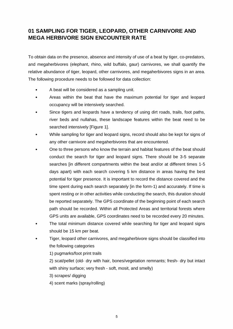
01 SAMPLING FOR TIGER, LEOPARD, OTHER CARNIVORE AND
MEGA HERBIVORE SIGN ENCOUNTER RATE
To obtain data on the presence, absence and intensity of use of a beat by tiger, co-predators,
and megaherbivores (elephant, rhino, wild buffalo, gaur) carnivores, we shall quantify the
relative abundance of tiger, leopard, other carnivores, and megaherbivores signs in an area.
The following procedure needs to be followed for data collection:
• A beat will be considered as a sampling unit.
• Areas within the beat that have the maximum potential for tiger and leopard
occupancy will be intensively searched.
• Since tigers and leopards have a tendency of using dirt roads, trails, foot paths,
river beds and nullahas, these landscape features within the beat need to be
searched intensively [Figure 1].
• While sampling for tiger and leopard signs, record should also be kept for signs of
any other carnivore and megaherbivores that are encountered.
• One to three persons who know the terrain and habitat features of the beat should
conduct the search for tiger and leopard signs. There should be 3-5 separate
searches [in different compartments within the beat and/or at different times 1-5
days apart) with each search covering 5 km distance in areas having the best
potential for tiger presence. It is important to record the distance covered and the
time spent during each search separately [in the form-1) and accurately. If time is
spent resting or in other activities while conducting the search, this duration should
be reported separately. The GPS coordinate of the beginning point of each search
path should be recorded. Within all Protected Areas and territorial forests where
GPS units are available, GPS coordinates need to be recorded every 20 minutes.
• The total minimum distance covered while searching for tiger and leopard signs
should be 15 km per beat.
• Tiger, leopard other carnivores, and megaherbivore signs should be classified into
the following categories
1) pugmarks/foot print trails
2) scat/pellet (old- dry with hair, bones/vegetation remnants; fresh- dry but intact
with shiny surface; very fresh - soft, mosit, and smelly)
3) scrapes/ digging
4) scent marks (spray/rolling)
5

5) rake markes on tree trunks
6) vocalisation
7) direct sighting
• In case of pug mark trails, each trail set is considered as one sign [not each pug
mark as one sign). In case a tiger [or other carnivore] continues to walk along a dirt
road for a long distance (say 1 km). then this should be considered as one sign,
and a comment recorded in the remarks section of the data regarding distance
covered by a pug mark trail of a single tiger.
• Tiger and leopard signs if encountered outside of the sampling route should also
be recorded with GPS coordinates (if available] and with appropriate comments.
• Special emphasis should be given to sign of tigress & leopards with cubs, and any
authentic evidence of tiger cubs [sightings of cubs, lactating tigress, tracks, etc.]
obtained within the past twelve months should be mentioned in the data sheet.
• The number of livestock that are killed by predators within the past three months
needs to be recorded in the questionnaire following the data sheet.
• It is important to report data sincerely. It is likely that there may be reliable
information that tiger/leopard is present in the beat being sampled, but no
tiger/leopard signs are recorded during the intensive search survey. In such cases,
mention should be made in the remarks column of the data sheets. However,
failure in obtaining tiger sign from a beat is equally important as recording
tiger/leopard signs and for appropriate analysis of this data the actual data should
be reported.
• Periodicity: All forested beats in tiger landscapes (Tiger Reserves, Protected
Areas, Reserve and Protected Forests, Revenue Forests] will be sampled once in
four years. All source populations of tigers (Tiger Reserves and Protected Areas]
will be sampled with this protocol twice in a year (summer and winter].
6

DATA SHEET FOR TIGER, LEOPARD, OTHER CARNIVORE & MEGA HERBIVORE SIGN ENCOUNTER RATE
FORM-1
Forest Division: Start Time: Starting Latitude: N End Latitude: N Total distance covered: Km
Range: Beat: End Time: Starting Longitude: E End Longitude: E Time spent in other activities [resting etc.]:
Date: Trail ID:
Team Members Name Designation Phone No.
1
2
S.No. Time Latitude Longitude Sign Type
Species Age of Track/Sign**
Remarks
Deg. Min. Sec. Deg. Min. Sec.
In case of direct sighting of animals please note down individual number, age & sex of the animals (if identifiable) in remarks
*Sign types-: Scat/Pellets/Dung-SCT/PLT/DNG, Pugmark_Track - PT, Vocalization-VG, Rake-RK, Scrape-SCR, Rolling-RL,
Spray-SPR, Digging-DIG, Kill- K, Scat & Scrape- SS
** Age of Track & Sign : Very Fresh- VF, Fresh- F, Old-0, Very Old- VO
Records signs of Mega Herbivores [Elephant, Gaur, Rhino & Water Buffalo]
Note: 1. If you get more sign than these, then enter it on another datasheet.
7

1] Has any tigress with cubs been reported during the past 12 months
Yes [ ] / No [ ] Approx. Date/Month:
a] Seen by staff [ ] b] Pugmarks [ ]
cl Reported by local person [ ] d] Seen by official [ ]
How many cubs: Approx. age of the cubs: months
2] In case tigers are known to be present in the beat, but no sign was obtained during
the sampling period then mention on what evidence was this conclusion made
a] Pugmark [ ] b] Direct sighting [ ]
cl Scat [ ] d] Other sign [ ]
Approx. Date/ Month:
Tiger presence was last recorded in the beat:
3] Has any leopard with cubs been reported during the last 12 months:
Yes [ ]/No [ ] Approx. Date/Month:
a] Seen by staff [ ] b] Pugmarks [ ]
c] Reported by local person [ ] d] Seen by official [ ]
How many cubs: Approx. age of the cubs: months
4] In case leopard are known to be present in the beat, but no sign was obtained during
the sampling period then mention on what evidence was this conclusion made
a] Pugmark [ ] bl Direct sighting [ ]
cl Scat [ ] d] Other sign [ ]
Approx. Date/ Month:
Leopard presence was last recorded in the beat..................
5] How many livestock predation events has been recorded in the past 3 months, by
Tiger........., by Leopard............., by Dhole.............,
By other carnivores [specify which carnivores] ...............No. of events:............
6] Comments & remarks: ..........................................................................................
8

02 SAMPLING FOR PREY SPECIES ABUNDA NCE
This protocol outlines a simple method for quantifying ungulate abundance in a are based on visual encounters while walking along fixed line transects. The following procedure needs to be followed for data collection:
A beat would be considered as the unit for sampling.
After considering the shape, size, vegetation, and terrain type of the beat, a transect line of a minimum of 2 km and net exceeding 4 km will be marked for sampling.
The transect line should traverse similar habitat (broad vegetation types) as far as possible. If the beat is composed of 2 or 3 distinct vegetation types eg. Mixed teak forests comprising 40% of the beat and the remaining 60% comprised of miscellaneous forest with bamboo, then 2 separate line transects should be marked for sampling as shown in Figure 2b.
If the beat size is smaller, and 2 km line transect cannot be marked, then lay a transect of 1 km and walk that transect six times.
Figure 2, Marking transects in beat.
As shown in figure 2b, the line transect within a beat may be broken up into 2 or more
segments, so each segment has a minimum length of 2 km and traverses’ similar habitat.
Care should be taken that a line transect is not located near a busy road nor should it run
parallel to a river or other features the landscape which may bias sighting of ungulates.
9

• For each transect the beginning and end point coordinates [Latitude and
Longitude I should be recorded by a global positioning system [GPS] receiver.
• The broad forest type* and terrain type** that the transect traverses needs to
be recorded.
• Each transect should be walked by 1-2 persons during the early morning hours
[6:30 AM to 8:30 AM]. Preferably, one of the persons walking should be a good
field person who is able to spot wildlife.
• A record should be kept of all herbivores [and other listed wildlife] seen during
the walk in the prescribed format [see form! For each animal sighting the
following needs to be recorded: 1] sighting number, 2] time of the sighting, 3]
species (e.g., sambar, ch ital, wild pig etc.]. 4] group size - number of animals
of the same species in the group sighted, it is important to try to count the
number of animals in the group as accurately as possible. Animals are
considered to belong to two different groups if the closest animals from the two
groups are separated by a distance of over 30m, 5] forest and terrain type
where the animals were seen, 6] an estimate of the distance to the centre of
the animal group from the observer, preferably recorded by a range finder, 7]
the bearing of the centre of the animal group sighted, preferably recorded by a
see through compass, and 8] GPS location on the transect line from where the
animal was sighted.
• If possible, the number of young [fawns/calves less than 1 year of age] seen in
the group should also be recorded.
• A broad habitat category (vegetation* and terrain type**] needs to be recorded
for each sighting eg. 12 ch ital [10 adults and 2young] were seen at 6:40 am,
in mixed teak forest, gently undulating terrain at 20 m distance and 175°
bearing.
• Each line transect needs to be walked at least on three different mornings for
estimating ungulate abundance during the country wide monitoring done every
four years.
10

• For intensive monitoring of source populations (Tiger Reserves and Protected
Areas] the line transects should be walked a minimum of eight times in summer
and in winter.
• Habitat type should be one of the following: Agriculture/Plantation, Alpine
meadows, Bamboo, Coniferous Forest, Desert rocky, Desert sandy, Dhonk
forest, Fallow land, Himalayan broad leaved, Hollong forest, Mangroves,
Miscellaneous dry deciduous forest, Miscellaneous evergreen forest,
Miscellaneous moist deciduous forest, Miscellaneous semi-evergreen forest,
Orchards, Pasture, Sal Forest, Scrub, Shala grassland, short grassland, tall
grassland, Teak Forest, Thorn Forest, Riverine & Wetland.
** Terrain type should be one of the following: Hilly, Plain, Steep, Undulating,
Valley, very steep
.
11

SAMPLING FOR PREY SPECIES ABUNDANCE
FORM-2
Forest Division: Transect ID: Start time: Start Latitude: N End Latitude: N Weather: Sunny [ ] / Cloudy [ ] / Rain [ ]
Range: Transect Replicate: End time: Start Longitude: E End Longitude: E
Beat: Transect Bearing: Habitat type*:
Date: Transect length [Km]: Terrain type**:
Observers Name Designation Phone No.
1.
2.
S.No. Time Latitude Longitude Species Total Number (Adult & young)
Young Angular Sighting Distance
Compass bearing Habitat Type*
Terrain type **
Remarks
Deg. Min. Sec. Deg. Min. Sec. Animal Walk
Instructions:
1. The start and end time of the transect must be recorded.
2. The format of GPS location should be in degree-minute-seconds.
3. The walk bearing and animal bearing should be written while walking the 2 km transect
(The walk bearing and transect bearing can be different if line transect is passing through hill or different terrain).
12

03-SAMPLING FOR VEGETATION AND HUMAN DISTURBANCE
To quantify the habitat parameters and determine levels of human disturbance,
sampling will be done along the same line transect on which ungulate encounter rates
were estimated. For economy of time and effort it would be possible to first sample the
line transect during early morning hours for ungulate encounter rate and then while
returning along the same line, sample for vegetation and human disturbance [and also
for ungulate pellets - section 4). Sampling for vegetation and human disturbance [and
ungulate pellets] will be done only once on a transect, in a season.
• Again, a beat will be the sampling unit, and sampling will be done along the established
line transect.
• Vegetation and human disturbance would need to be sampled every 400 m along the
transect. GPS coordinates for each plot should be recorded.
• For transects where the vegetation is cleared for walking, the observer should walk
15m perpendicular to the walking path and then sample the vegetation and human
disturbance plot [Figure A]
• For each plot broad habitat type* and terrain type** should be recorded.
• Figure A: Placement of vegetation and human disturbance plots along the transect;
and dimensions of sampling plots for trees and human disturbance signs [15 m radius],
shrubs and weedy/invasive shrubs [5 m radius] and herbs, grasses and ground cover
(1 m radius).
*Habitat type should be one of the following: Agriculture/Plantation, Alpine meadows,
Bamboo, Coniferous forest, Desert rocky, Desert sandy, Dhonk forest, Fallow land, Himalayan
broad leaved, Hollong forest, Mangroves, Miscellaneous dry deciduous forest, Miscellaneous
13

evergreen forest, Miscellaneous moist deciduous forest, Miscellaneous semi-evergreen
forest, Orchards, Pasture, Sal forest, Scrub, Shala grassland, Short grassland, Tall grassland,
Teak forest, Thorn forest, Riverine & Wetland.
**Terrain type should be one of the following: Hilly, Plain, Steep, Undulating, Valley, Very
steep.
The vegetation and human disturbance would need to be quantified visually at the following
categories for each plot:
a) Tree species (15m radius plot):
A circular plot of 15 m radius should be visually marked. The observer needs to enlist
all the tree species [allvegetation> 6 ft/2 min height, including bamboo] and record
number of every tree species. A maximum of 10 tree species should be recorded.
Example:4 trees of Shorea robusta, 2 trees of Syzygium cumini, 3 clumps of
Dendrocalamus strictus etc. In the same plot, canopy cover for each plot should be
recorded by visually estimating the percent visible open sky from five different
locations along the diagonal of the plot and enter the averaged value.
b) Shrub species (5m radius plot):
A circular plot of 5 m radius should be visually marked. The observer needs to enlist all
the shrub species [allvegetation in between 40 cm to 2.0 min height] and record
percent cover of every shrub species. A maximum of 10 shrub species should be
recorded. Example: 20% Carrisa opaca, 10% Shorea robusta, 5% Ma/lotus
philippensis etc.
c) Weedy/Invasive shrub species (5m radius plot):
Within the same circular plot of 5 m radius, observer needs to enlist all the
weedy/invasive shrub species [all vegetation in between 40 cm to 2.0 m in height] and
record percent cover of every weedy/invasive shrub species. A maximum of 3
weedy/invasive shrub species should be recorded . Example: 25% Lantana camara,
10% Pogostemon benghalensis, 2%Senna tora etc.
d) Grass and Herb species (1m radius plot):
A circular plot of 1m radius should be marked. The observer needs to enlist the grass
and herb species [all vegetation< 40 cm in height] in order of their abundance, such
that the most abundant species is entered first followed by the less abundant one. A
maximum of three grass and three herbs should be recorded .
14

e) Ground cover (1m radius plot):
Within the circular plot of 1 m radius used for recording grass and herbs, observer
needs to record percentage of dry leaf Litter in the plot. This Litter should be removed
and subsequently percentage ground cover of green grass, dry grass, herbs, weeds,
and bare ground, needs to be recorded; this should add upto 100%.
f) Human disturbance signs (15m radius plot):
Within the circular plot of 15 m radius used for counting trees, observer needs to
record 1] number of trees lopped, 2] number of trees cut, 3] evidence of grass and
bamboo cutting (as present or absent]. 4] number of people seen from the plot, 5]
number of livestock seen from the plot and 6] Livestock-human foot trails within the
plot. Wood cutting/ Lopping by forest department should also be counted.
Observer needs to mention the number of permanent human settlements, human
population, and Livestock population present in the beat (to the best of knowledge].
Observer needs to note if non-timber forest product (NTFP] is collected from the beat.
If yes, which NTFP (maximum 4] and the magnitude of collection on a 5-point scale
(0- no collection 4-high rate of collection]. Observer needs to note the fire extent in
beat in past twelve months on a 5-point scale (0- no fire, 4-fire insubstantial area of
beat].
15
SAMPLING FOR VEGETATION & HUMAN DISTURBANCE FORM – 3 A, B
Observer name: Date: Beat: Habitat type:
Latitude: N Division Transect ID: Terrain type:
Longitute :E Range: Plot ID:
A: Plant species numbers in different sizes of plots
Trees (F-3A)
(15m radius)
Shrubs (F-3A)
(5m radius)
Shruby weeds (F-3A)
(5m radius)
Herbs (F-3C) (1m radius)
Grass (F-3C) (1m radius)
Species Number Species Percent Cover Species Percent Cover Species Species
Canopy Cover (0.0-1.0):
B: Human Disturbance Sign in 15-Meter radius
No. of Tree Cutting No. of Lopped Branches
No. of Human/Livestock trail
People seen Livestock seen Grass/Bamboo Cutting (Yes/No)
Are there any permanent human settlements in the beat? (Yes/No). If Yes, how many? __ . Approximate human population ____ approximate livestock population ___ Cattle, ___ Goat/Sheep, ___ Other Livestock. Is there NTFP collection in the beat __ Yes/No. If yes, what NTFP is collected ________________________________ Fire extent in the beat in past 12 months on a scale of 0-4, 0-No to 4 Very high __________________________________
C: Ground cover in 1-meter radius plot
Sum of the following 5 column should be 100%
Dry Leaf Litter (%) Dry Grass (%) Green Grass (%) Herb(%) Weed(%) Bare Ground (%)
Note: Bamboo more than 2 mis entered in "Tree" category less than 2m in "Shrub" category
16

04 SAMPLING FOR UNGULATE PELLETS/ DUNG
Ungulate abundance will also be indexed by enumerating their faecal pellets. This exercise will
be done on the same line transect that has been sampled for ungulate encounter rate. To save
time, this exercise could be done after the line transect has been sampled in the early morning
for ungulate encounters and whilst doing the habitat and human disturbance sampling.
• At every 400 m along the transect [line of walk) the observer needs to sample an
area of 2 m by 20 m, perpendicular to the transect for quantifying ungulate pellets.
This is done by using the 2 m long stick held at the centre horizontally in his hand
and by walking slowly looking left and right for 20 m. The plot is placed alternately to
the right and left of the transect at every 400 m [see Figure 7).
• All ungulate pellets encountered need to be recognized to ungulate species and
recorded in appropriate columns of the attached data sheet [see Appendix 31.
• The number of faecal pellets need to be counted. In cases where the pellets occur in
large heaps, and if exceeds> 1000, then enter as 999 .
• In areas where small livestock like sheep and goat are known to be grazing, it is possible
that feacal pellets of these can be confused with wild ungulates especially those of chital.
In such areas, a mention needs to be made that goat or sheep graze the area.
17

SAMPLING FOR UNGULATES FORM-4
PELLETS/DUNG
Name of Observer: Date Forest Division Range
Beat: ID No. of Line Transect:
Plo
t
Ch
ita
l
Sa
mb
ar
Wild
Pic
Nilg
ai
Ga
ur
Ba
rasin
gh
a
Ba
rkin
g D
ee
r
Ho
g D
eer
Ch
inkara
Ch
ow
sin
gh
a
Mo
use
de
er
Ha
re
Bla
ckbu
ch
Wild
bu
ffa
lo
Ele
ph
an
t
Rh
ino
Langur
Pe
afo
wl
Ca
ttle
Go
at &
Sh
ee
p
Oth
er
Dom
estic
live
sto
ck
Oth
ers
/Un
it.
1.
2.
3.
4.
5.
6.
7.
8.
9.
10.
1. Do goat/sheep graze the sampled area? Yes / No.
Note: If, Pellets exceed 1000 then enter them as 999.
18

PROTOCOL OF CARNIVORES SCAT & LARGE HERBIVORES DUNG
COLLECTION
Collect scat samples of carnivores and dung of large herbivores, as and when
encountered in field according to the following protocol.
1. Carry paper bags, zip lock bags whenever you go to field.
2. If you get
a. Very fresh/Fresh scat sample –Collect in whole bolus in zip locks with silica
as mentioned below and rest of scat, put it in paper bags.
b. Old scat sample – collect in zip lock with silica and rest in paper bag.
c. Very old scat sample- collect it in paper bags only.
3. When you encounter a scat sample, collect a part of it in the ziplock bag as mentioned
below.
Use an empty ziplock bag
Fill approximately 1/5th of the ziplock with silica gel.
If the scat is intact, try and collect one or two intact bolous of scat
in to the zip lock, otherwise collect approximated – 15 g. Do not
touch the scat directly with your hand. Use a leaf/twig of stone to
put the the scat into the ziplock. Seal tightly after removing any air.
4. Write details of species, GPS location, place (State, Division, Range and Beat) and
date of collection on the ziplock bags.
5. If you come across the carcass of any dead animal collect 5-10 gm of tissue for the
reference. This can be collected in ziplocks with silica gel and later transferred to vials
with ethanol.
6. Finally, send ziplocks, paper bags and /or vials with tissue samples, along with data
sheet without any delay by post/courier to:
Nodal Officer, NTCA-WII Tiger Cell, Wildlife
Institute of India, PO box # 18, Chandrabani,
Dehradun, Uttrakhand – 248001.
19

Usage notes for using MSTrIPES
ECOLOGICAL Mobile application
20

I. Installation of MSTrIPES ECOLOGICAL application in mobile phone • To install the MSTrIPES ECOLOGICAL application, you must have an Android device, version
7.1.1 or higher. This application will not support iOS or Windows OS mobile devices.
• This application can be installed on the phone by two ways.
1. Download from Google Play Store. For this, user will require an Internet connection and a
valid Gmail ID.
a. Search in the search bar of Google Play Store for MSTrIPES Ecological Application.
b. Select the MSTrIPES Ecological application and click on INSTALL.
c. Wait until the application is installed and close the Google Play Store after the process is
complete (Do not click on Cancel).
21

2. Offline installation by APK file of MSTrIPES ECOLOGICAL application.
a. Keep the APK file of the MSTrIPES ECOLOGICAL application in your phone's file manager
(Internal Memory or External Memory).
b. Find the installer APK file in the phone's file manager and INSTALL the application. Wait
until the installation completes. Once the installation has finished click on DONE.
22

Steps for data collection using MSTrIPES ECOLOGICAL application
• Click on the Ecological App icon on the phone screen and provide all the necessary
permissions it asks (e.g. Camera, Contacts, Location, and Storage) for smooth functioning of
the app.
Note: If you decline the required permissions, the app will not work correctly.
• After the app starts, select the Language according to your convenience.
23

• Fill in the required information and register yourself in the app. If all the information has been
filled in correctly, then click OK on the confirmation message, otherwise click CANCEL and
correct the information, and register.
• After the registration is successful, this home page will appear on your screen.
24

Modify system settings (Battery optimization)
This is a user dependent/ optional permission which is required only to reduce the phone battery
consumption while operating the application. It reduces the screen brightness when the Map Page
Screen (described later in Occupancy F1/ Transect F2 section) is locked during occupancy trail/
transect.
• User needs to tap on New Occupancy Trail F1/ Start Transect F2 button after the Home Page
appears and it will prompt the user to Modify system settings.
• This message box will appear upon tapping on the button, and user needs to select Yes in
order to modify the settings.
25

• User needs to scroll and search for Ecological application and select the same.
• User needs to allow the application to modify system settings by sliding the button.
• Once permission is provided, user needs to select the Back button to return to Home page.
26

• Click on the menu bar button ( ) on the home screen before walking trail or transects.
• To add Team members to the list, click on Add Team Member, fill in the necessary
information, and click Save Details. The name of all the persons added will appear on the list.
Note: If there is no change in the team member, then do not add team member name in the
list during every survey.
27

• To inform others during any emergency, add the contact in SOS Details. Here, add the number
of your senior officer or your family members. This sends SMS alerts to your selected contacts
with the GPS coordinates of your location.
• Use the OFFLINE MAP in areas where there is no network connectivity. To load the offline
map, click on the Offline Map and follow the steps. Offline map (.mbtiles) should be kept in
the internal memory of the phone. Wait until the map is loaded successfully. After loading
the map successfully, press the back button and go to the home screen.
28

29

• Before starting any form, click on the STATUS for GPS stabilization. For the accuracy of GPS, it
is mandatory to have a minimum of five satellites in the fix (See # of Satellites).
30

II. Detailed step for recording Sign Survey (Form-1) data using MSTrIPES
Ecological mobile application
Step 1: Click on the NEW OCCUPANCY TRAIL icon to start the sign survey (Form-1).
31

Step 2: Select all the Administrative details and Trail number (sign survey route), make sure
that you have switched on the GPS, click on the Team Photograph and take the photo of all
the team members (Selfie), and click on NEXT to proceed to the next page. It is not possible
to go to the next page without taking a team photo.
Step 3: If all the details are correctly filled then click YES on the confirmation message
otherwise click NO, fill in the correct details and click on NEXT.
32
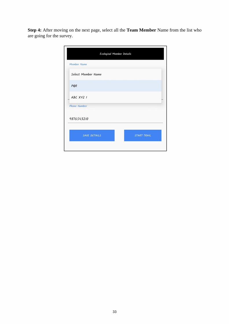
Step 4: After moving on the next page, select all the Team Member Name from the list who
are going for the survey.
33
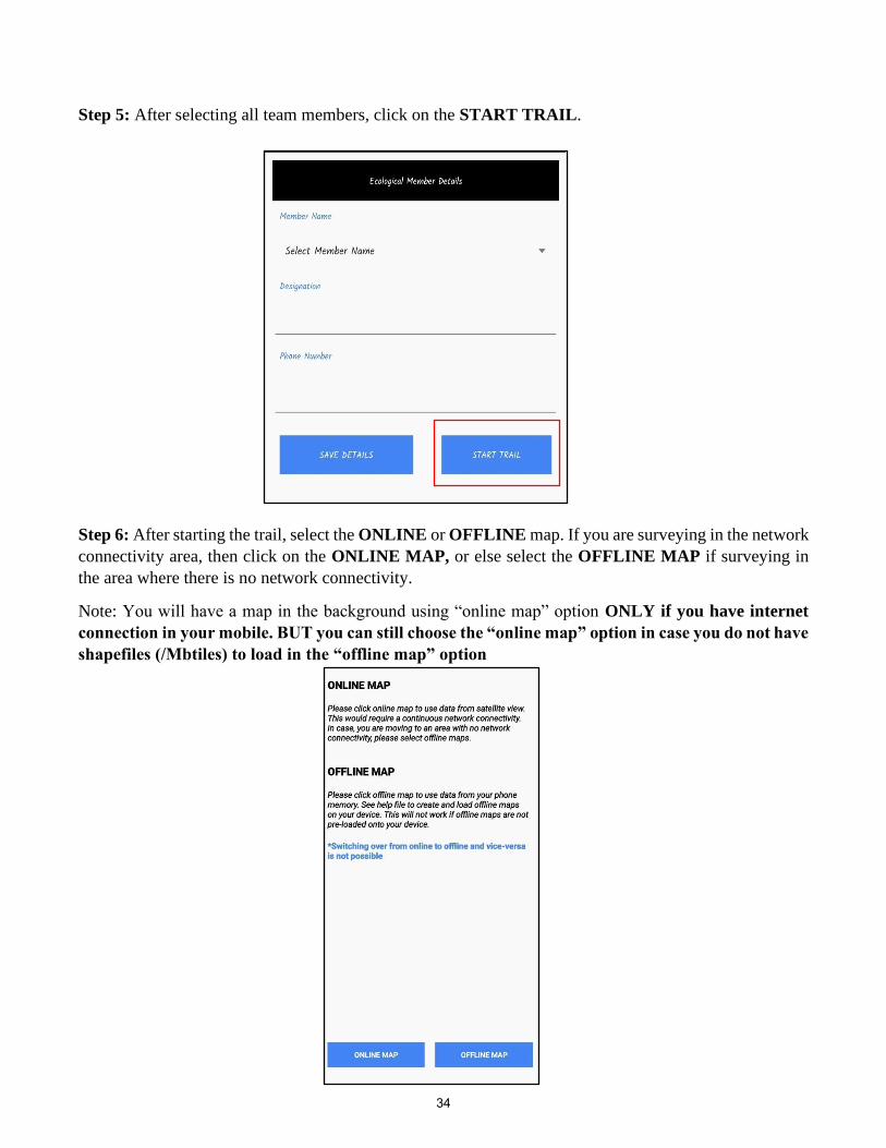
Step 5: After selecting all team members, click on the START TRAIL.
Step 6: After starting the trail, select the ONLINE or OFFLINE map. If you are surveying in the network
connectivity area, then click on the ONLINE MAP, or else select the OFFLINE MAP if surveying in
the area where there is no network connectivity.
Note: You will have a map in the background using “online map” option ONLY if you have internet
connection in your mobile. BUT you can still choose the “online map” option in case you do not have
shapefiles (/Mbtiles) to load in the “offline map” option
34

Once the user clicks on offline map, it will browse to the internal memory where the MB tiles is stored.
Here select the MB tiles of the area being surveyed. User has to import the MB tiles as shown in the
image below. Once the MB tile is created user will get a geo referenced background map.
35

Step 7: The survey or walk can be started after coming to this map page (wait for the GPS to stabilize).
The red balloon depicts your current location. As the survey progresses, the route map and distance of the
survey can be seen on the top of this page.
Step 8: After getting the direct/indirect sign(s) of any Carnivore Species or Mega Herbivore Species,
click on Form-1 to record the observation.
36

Step 9: After clicking on Form-1, observation recording page will open. Record the SIGN TYPE,
SPECIES, AGE OF TRACK AND SIGN data based on the sign observed, capture photograph of sign
observed (not mandatory) then click SAVE DETAILS. In case of direct sighting of any species, you need
to enter total number of individuals seen with details on male, female and young seen. Enter unknown for
individuals you are not sure about their age and gender.
Step 10: After completing the trail survey, click on the Questionnaire form, fill in all the information
then click SAVE DETAILS.
37
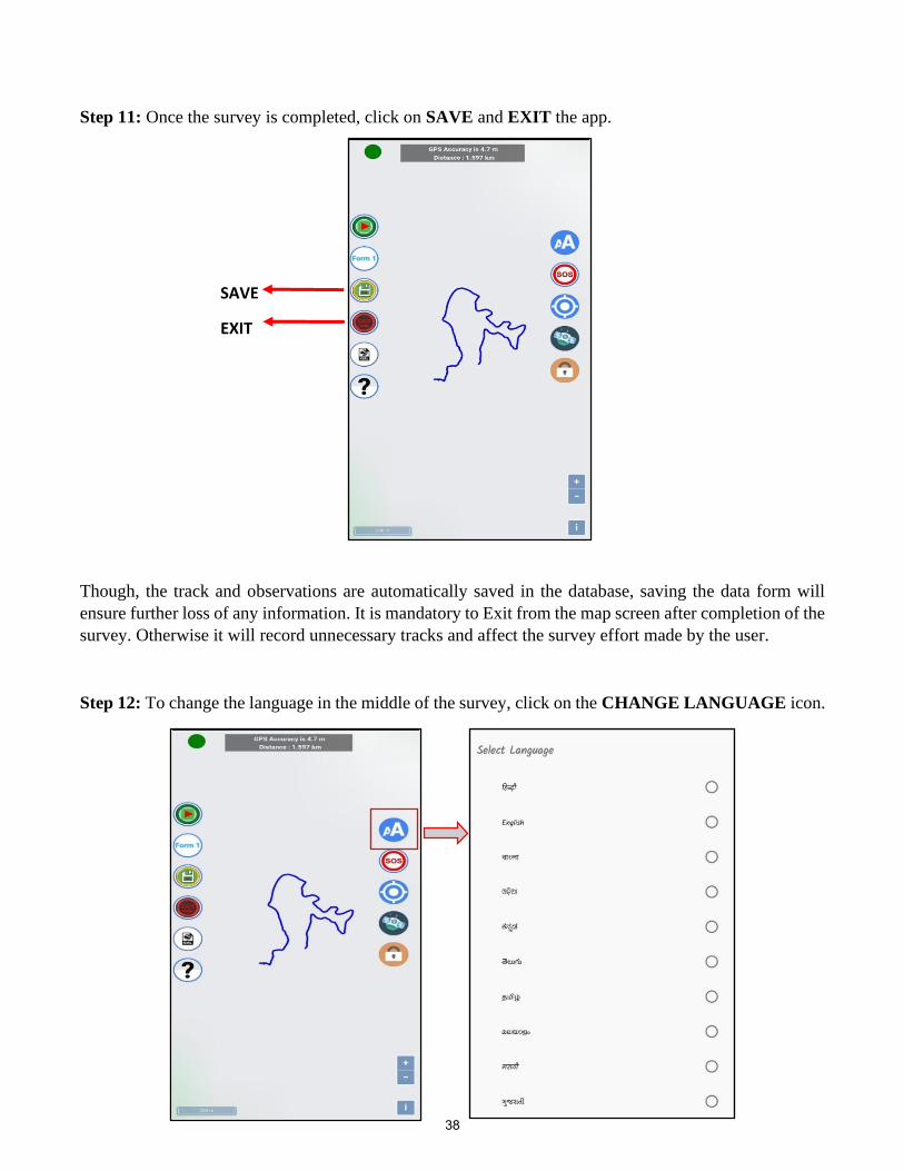
Step 11: Once the survey is completed, click on SAVE and EXIT the app.
Though, the track and observations are automatically saved in the database, saving the data form will
ensure further loss of any information. It is mandatory to Exit from the map screen after completion of the
survey. Otherwise it will record unnecessary tracks and affect the survey effort made by the user.
Step 12: To change the language in the middle of the survey, click on the CHANGE LANGUAGE icon.
SAVE
EXIT
38

Step 13: During the survey, if the phone turns off or the app crashes due to any reason, click on the
Continue Old Trail to re-start the survey from where the survey was closed.
Step 14: Once all the necessary edits are finished, go to the dashboard and select Backup as shown in
the image below. Once the backup is completed you will get a notification has Backup Finished.
Go back to your internal storage and you can find the folder MSTRIPES_ Ecological where your
backup will be stored.
39

III. Detailed step for recording Line Transect (Form-2) using MSTrIPES Ecological mobile
application
Step 2: Enter administrative details of your data collection area here by
choosing the state, division, range and beat from the drop down list in the
right side
Step 1: Once all the necessary details are filled (refer notes
on Steps for data collection using MSTrIPES
ECOLOGICAL application), start the data collection for
line transect data by clicking on “Start Transect F2”. of form
2 (line transect) please click here
40

1 2 3
4 5
41

Step 3: On this page enter all the
transect details as follows
1. Enter the transect ID and
replicate ID and transect
bearing. Measure the
bearing using a compass.
2. Weather condition on that
particular day.
3. Select the overall transect
habitat from the drop down
list.
4. Select the overall terrain
type of the transect from the
drop down list
5. If the same transect id and
replicate id exists in the
user’s phone then the app
will show a notification
saying the details are
already existing as shown
in the screen.
42

Step 5: Next select team member details from the drop down list.
Here list of names that were saved during the steps in “Steps for data
collection using MSTrIPES ECOLOGICAL application” will
appear in the drop down. Once the team member name is selected,
it will automatically fill the designation and phone number of the
concerned staff. (*Only the team member details already added
earlier will be visible in the dropdown list if the user wants to
add any new member then do that from “add team member
details” from the dashboard).
Click “save details” after filling the details.
Step 4: Once all the required transect details are filled click next button. Confirm
that all the details entered are correct or click “No” and edit the details.
43
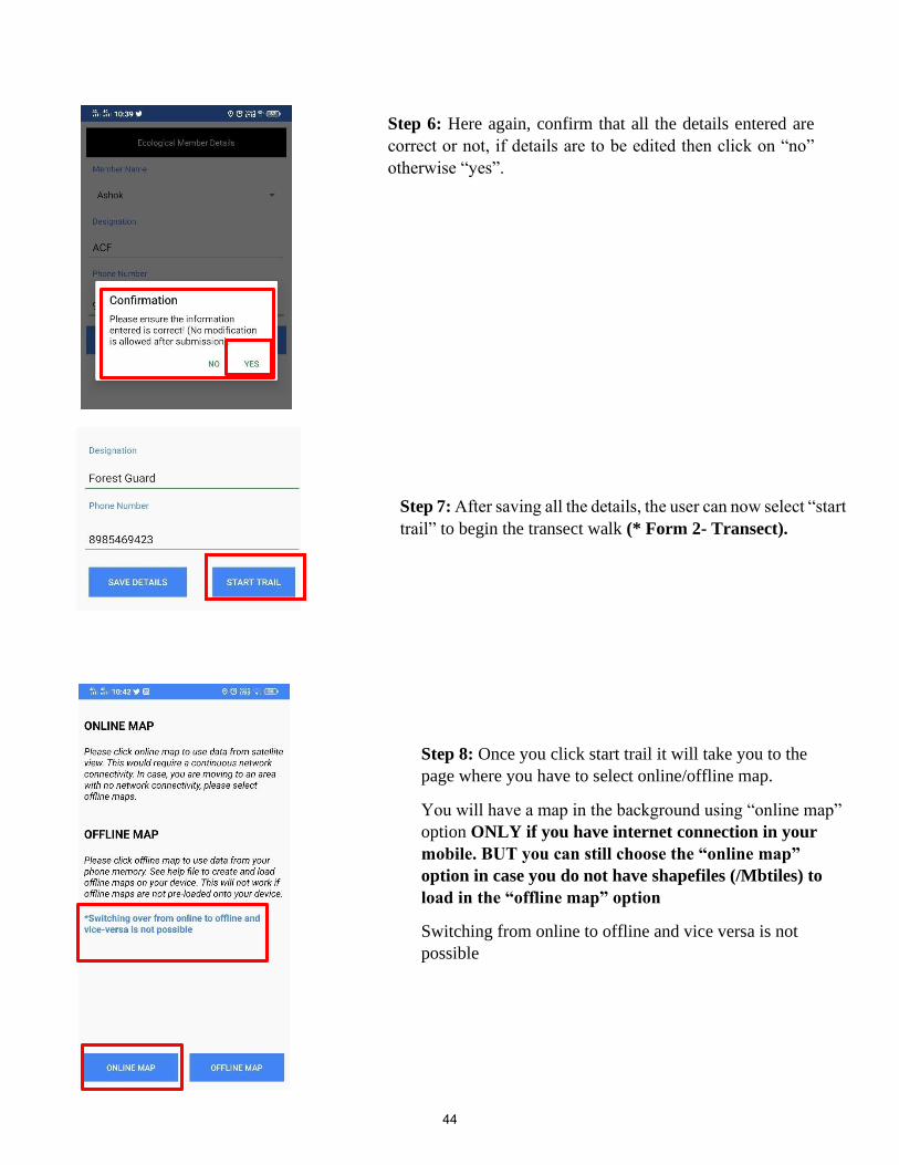
Step 6: Here again, confirm that all the details entered are
correct or not, if details are to be edited then click on “no”
otherwise “yes”.
Step 7: After saving all the details, the user can now select “start
trail” to begin the transect walk (* Form 2- Transect).
Step 8: Once you click start trail it will take you to the
page where you have to select online/offline map.
You will have a map in the background using “online map”
option ONLY if you have internet connection in your
mobile. BUT you can still choose the “online map”
option in case you do not have shapefiles (/Mbtiles) to
load in the “offline map” option
Switching from online to offline and vice versa is not
possible
44

If the user clicks on offline map, app will browse to the internal memory where the MB tiles is stored. Here select
the MB tiles of the area being surveyed. User has to import the MB tiles as shown in the image below. Once the
MB tile is created user will get a geo referenced background map.
Step 9: After selecting the map option, this page will
appear with current location (lat/lon) displayed. Make
sure you have switched on the GPS,
45

Step 10: When any species of interest is sighted during the
walk click the form 2 tab, where details of the sighting are to
be entered.
46

1 2 3
Step 11: On this page enter all the details related to the species sighting as follows:
1. & 2. Once form 2 tab is selected, user will enter a page where they can select species sighted form the drop
down list
3. After selecting species from the list enter the details of number of animals seen including the young ones if
seen (*Make sure the values entered in young ones should not be more than the total animals seen).
47

4. Select the habitat type and the terrain type from the drop down list were the animal is
encountered.
5. Enter the animal bearing using the compass that you are carrying.
6. Form will automatically fill in the walk bearing using the transect bearing entered in
step 3, but you need to ensure that your walk bearing is same as your transect bearing,
During transect walk sometime minor deviation happens due to terrain and
obstruction on the way of transect line. Hence it is strongly advised to record and
enter walk bearing. Please ensure that the deviation should be minimal. Measure the
radial distance using the range finder and record in the application. Take photo of the
animal encountered if possible and click “save details”.
4 5 6
48

Step 12: Once the survey is completed, click on SAVE and EXIT the app.
SAVE
EXIT
Step 13: In case the same transect needs to be continued later on, then click the tab “continue old transect F2”.
As shown in the image the old trail will appear in Red and the continued trail will appear in Blue color
49

Step 14: To change the language in the middle of the survey, click on the CHANGE LANGUAGE
icon.
Step 15: Once all the necessary edits are finished, go to the dashboard and select Backup as shown in
the image below. Once the backup is completed you will get a notification has Backup Finished.
Go back to your internal storage and you can find the folder MSTRIPES_ Ecological where your
backup will be stored.
50

IV. Detailed step for recording Habitat Plots (Form-3 A,B,C) and Pellet (Form 4) data using
MSTrIPES Ecological mobile application
Step 1: Select the “Habitat plot” icon on the home screen to enter vegetation data of the line
transect. Enter the details as follows:
1. Fill the information on state, division, range and beat using the drop-down option
2. Select the transect on which the plot is to be sampled. All existing transects are
highlighted in green
1
2
Step 2: Click on the plot number to be sampled. Usually plot zero is at the start/end of the
transect, and the subsequent plots are at every 400 meters
51
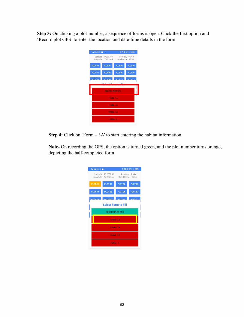
Step 3: On clicking a plot-number, a sequence of forms is open. Click the first option and
‘Record plot GPS’ to enter the location and date-time details in the form
Step 4: Click on ‘Form – 3A’ to start entering the habitat information
Note- On recording the GPS, the option is turned green, and the plot number turns orange,
depicting the half-completed form
52

Step 5: On clicking form 3A the following screen will open, here enter the information of canopy
density, habitat types and terrain type describing the 15 m radius plot, using the drop-down menu. Take
a photograph of the plot habitat. This photo is geo-tagged.
53

Step 6: Select the “Tree species” option to enter the names and number of trees in a plot of 15 m radius.
In this form enter tree species names from the drop-down menu. Scientific and local names are available
here. Enter the number of trees for every species entered
Step 7: Select the “Shrub species” option to enter the names and percent cover of shrubs in a plot of 5
m radius. In this form enter shrub species names from the drop-down menu for and percent cover of
every recorded shrub species in a plot. The total of all percentage cover should be equal to or less than
100%.
54

Step 8: Select the “Weed species” option to enter the names and percent cover of invasive species and
weeds in a plot of 5 m radius. In this form enter Weed species name from the drop-down menu and
percent cover of every recorded invasive weed species in a plot. The total of all Percentage cover should
be equal to or less than 100%.
Step 9: Click on save after filling in all the information and exit the form.
Step 10: On recording and saving all entered information in FORM-3A, the option is turned green. Now
click on ‘Form – 3B’ to start entering the information on Human disturbance. Here, enter the following
information:
1) total number of trees felled in the 15 m radius plot.
2) total number of branches lopped in the 15 m radius plot.
3) total number of human or livestock trails in the 15 m radius plot.
4) total number of people other than the sampling team, sighted from the plot
5) total number of livestock sighted from the plot
6) Click either yes or no for the presence of grass/bamboo cutting
Take a photograph of the plot to depict human disturbances in the plot and click ‘save, to exit, after
filling all information
1
2
3
4
5
6
55

Step 11: On saving the human disturbance form on any plot of a transect, a questionnaire survey appears
once. Here a summary of human presence within the beat must be entered. Do it for any one plot on a
transect. Click yes or no for the presence of human settlement in the beat, if yes is selected follow-up
questions shall appear. Click yes or no for the presence of NTFP collection in the beat, if yes is selected
follow-up questions shall appear. Enter the extent of fire/brining in the beat in past 12 months, where 0
= no fire, 4 = >50% beat burnt.
Click ‘save, to exit, after filling all information
Step 12: On recording and saving all entered information in FORM-3B, the option is turned green. Now
click on ‘Form – 3C’ to start entering the information on ground cover.
In a 1 m radius plot, enter the percent cover of dry leaf litter. Remove the leaf litter after this. In the
remaining plot, enter the relative percent cover of dry grass, green grass, herbs, weeds, and bare ground,
such that the total of these should be 100%
56

Step 13: Select “Grass_Species” to enter data on three dominant grass species in the 1 m radius plot.
Enter the species names in rank of their cover, such that the species with highest ground cover is entered
first. Click ‘save’ to exit, after filling all information
Step 14: Select “Herb Species” to enter data on three dominant herb species in the 1 m radius plot. Enter
the species names in rank of their cover, such that the species with highest ground cover is entered first.
Click ‘save’ to exit, after filling all information
57

Step 15: On recording and saving all entered information in FORM-3C, the option is turned green. Now
click on ‘Form – 4’ to start entering the information on dung plot
Step 16: In this form, select the species from drop down list and fill the pellet count number by typing
or scrolling. If no pellet is found in the plot, only answer the goat/ sheep grazing question and save the
form. For confirmation click on YES.
58

NOTE: Once all the forms recording the habitat data of a plot are filled, the Plot number colour will
change to green indicating that the user has filled all the forms details (3a, 3b, 3c and 4).
59

V. Detailed step for recording Vulture data (Form-5) using MSTrIPES Ecological mobile
application
Step 1: Click on Vulture/Other Birds F5 form and then fill the administrative boundary details and
confirm the details by selecting “yes” and if the details are to be edited then select “no” and edit the
details.
60

Step 2: After entering the details the form to enter vulture/other birds details opens. Here enter the
information on species name from the drop down list. Select the habitat type in which the bird was
sighted. Fill in the other details given in the form, confirm the data entered (by selecting “yes”) and save
details.
61

VI. Detailed step for editing records using MSTrIPES Ecological mobile application
Step 1: Once the user has recorded all the information and saved details, there is an option to edit saved
observations if wrong details have been entered. For this following steps are to be carried out:
1. Go to the dashboard and select edit data as shown in the image.
2. Once you click edit data It will ask you which form you would like to edit. In this example the user has selected Form 2 to be edited.
3. Once the form is selected a data table, containing information recorded in that form, will
appear . For eg: here details of the transect like administrative details with the transect id
and replicates are seen.
4. Click on the information that you wish to edit. Once the user does this, the app asks to
confirm that you want to edit the existing data.
5. Once you click yes, “edit form 2 records” tab appears on the screen. Here the user can also
see the trail walked with animals encountered in form of red balloon icons.
6. On clicking the red balloon icon, screen to edit the data opens. In this example species
name is changed from Chital to Nilgai. After editing the record, click save details.
7. Once the user selects “save details” the app shows a confirmation notification, asking the
user to confirm if the walk bearing and animal bearing are same or not. If this information has not
changed then click “yes” otherwise click “no” and change the bearing.
62

63

Appendix – I
64

65

66
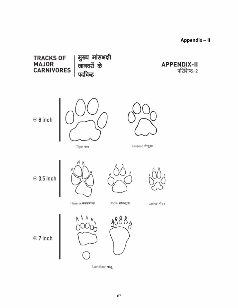
Appendix – II
67

APPENDIX – III
FECAL PELLETS OF WILD UNGULATES AND THEIR CHARACTERISTICS
SAMBAR
Though sambar occur in most forested areas, their preferred habitat is forested hilly areas with
ample water availability. Their fecal pellets are characterized by a barrel shape, the base of which
is flattened to concave in shape. The tip of the pellet tapers to a flattish point. Adult sambar pellets
range in size from 1.5 to 2cm in length and 0.8 to 1.4cm in diameter. Small size pellets from young
sambar can sometimes be confused with ch ital pellets due to overlap in size.
CHITAL
Chital are restricted to flattish or undulating forested terrain. They normally avoid steep hilly
terrain. Their fecal pellets are cylindrical with the bottom end rounded and the apical region
tapering to a point. Adult chital pellets range in size from 1.2 to 1.8cm, but are much slender in
comparison to sambar and nilgai pellets. In degraded areas ch ital pellets can be confused with
goat pellets.
NILGAI
Nilgai occur in open forests, scrub and thorn jungle, and degraded areas. They can also be found
at low densities in prime forests. Nilgai have a tendency to defecate at fixed Latrine sites forming
dung piles. The fecal pellets of nilgai are similar in size to sambar but are distinguished by a
cylindrical shape with flat or smooth angular surfaces. The base of nilgai pellets is not as flat as
that of sambar. Adult nilgai pellets 1.5 to 2cm in length with a diameter of 1 to 1.4cm on the
average. The color is often dark brown to blackish.
BARKING DEER
Barking deer pellets are Likely to be found throughout forested areas except in dry forested tracts.
The fecal pellets are elongated and crinkled often with a twisted Look and dented surface. The
pellets taper towards both ends giving a spindle shape, the tips vary from being long and hook
like to blunt. In a clump it is often common to encounter a Large variation in size and shape
between individual pellets from the same animal. They range in size between 1 to 1.8cm and
about 0.4 to 0.7 cm in diameter.
68

CHOWSINGHA
Chowsingha pellets are small in size. They vary in shape, being ovoid or slightly elongated. The
Length of the pellets vary between 0.6 to 1.2cm and the diameter is between 0.6 to 0.8cm. There
is a distinct habitat separation between chowsingha and blackbuck and therefore there is less
Likelyhood of confusing the pellets of the two species. Often habitats of chital, chowsingha and
barking deer may overlap.
69

APPENDIX-IV
70

APPENDIX – V
Initialization Procedure for GPS Units
1. Step 1: Press power button to switch on the GPS unit
2. Leave the unit on in view of the open sky for 15-20 minutes when first switched on after
several days.
3. Go to main menu by pressing Page button or Menu button depending on the GPS unit.
4. Select Setup from the Sub menu
5. Select Navigation from the Setup menu
6. Highlight position/location menu by pressing enter
7. Use arrow keys to scroll through the options and select hddd'MM" SS.S"'
8. Now Highlight Map Datum and select WGS 84 by pressing enter and scrolling through by the
arrow keys.
9. Highlight units and select metric units [in the same way as done above).
10. Highlight Heading and select True or Auto.
11. Quit the Navigation Menu
12. Select system setup and set date, time etc. [the Indian time is +5:30 hrs offset from GMT). In
offset feed in 5:30 to get correct local time displayed by the GPS unit instead of the GMT time.
13. Report the GPS coordinates in degrees, minutes and seconds in decimals.
71

72