Embed Size (px)
Citation preview
Monitoring super-volcanoes: geophysical andgeochemical signals at Yellowstone and other
large caldera systems
BY JACOB B. LOWENSTERN1,*, ROBERT B. SMITH
2AND DAVID P. HILL
1
1US Geological Survey, Volcano Hazards Team, MS 910, 345 Middlefield Road,Menlo Park, CA 94025, USA
2Department of Geology and Geophysics, University of Utah, 135 South,1460 East, Room 702, Salt Lake City, UT 84112, USA
Earth’s largest calderas form as the ground collapses during immense volcanic eruptions,when hundreds to thousands of cubic kilometres of magma are explosively withdrawn fromthe Earth’s crust over a period of days to weeks. Continuing long after such greateruptions, the resulting calderas often exhibit pronounced unrest, with frequentearthquakes, alternating uplift and subsidence of the ground, and considerable heat andmass flux. Because many active and extinct calderas show evidence for repetition of largeeruptions, such systems demand detailed scientific study and monitoring. Two calderas inNorth America, Yellowstone (Wyoming) and Long Valley (California), are in areas ofyouthful tectonic complexity. Scientists strive to understand the signals generated whentectonic, volcanic and hydrothermal (hot ground water) processes intersect. One obstacleto accurate forecasting of large volcanic events is humanity’s lack of familiarity with thesignals leading up to the largest class of volcanic eruptions. Accordingly, it may be difficultto recognize the difference between smaller and larger eruptions. To prepare ourselves andsociety, scientists must scrutinize a spectrum of volcanic signals and assess the manyfactors contributing to unrest and toward diverse modes of eruption.
Keywords: Yellowstone; super-volcano; super-eruption; caldera;volcano monitoring; eruption
On
*A
e c
ut
Anyone who has spent summers with pack-train in a place like theYellowstone comes to know the land to be leaping. The mountains arefalling all the time and by millions of tons. Something underground isshoving them up.
(T. A. Jaggar 1922, p. 352)
1. Introduction
During periods of volcanic unrest, scientists must intensively measure the signalsemanating from the volcano to determine whether an eruption is likely and toprovide appropriate warnings. The process of monitoring is complex, involving
Phil. Trans. R. Soc. A (2006) 364, 2055–2072
doi:10.1098/rsta.2006.1813
Published online 27 June 2006
ontribution of 20 to a Discussion Meeting Issue ‘Extreme natural hazards’.
hor for correspondence ([email protected]).
2055 q 2006 The Royal Society
J. B. Lowenstern and others2056
sophisticated equipment and data-reduction techniques, yet it relies ultimatelyon the subjective judgments of scientists who must weigh likely outcomesresulting from the observed volcanic behaviour. This contrasts with largetectonic earthquakes, which currently have no reliable precursory activity,relegating most human response to the aftermath of the event.
The largest scale of volcanic eruptions, the so-called super-eruptions, candestroy all living beings and infrastructure over tens of thousands of squarekilometres, can disrupt agriculture over millions of square kilometres and canalter global climate for years or decades. As such, society must endeavour tocreate reliable volcano-monitoring systems that can detect the sorts of Earthprocesses leading to large-scale explosive volcanism. Although the volcanologicalcommunity has had some success in predicting small eruptions, the scarcity ofgreat eruptions over the past 150 years means that we have little experienceunderstanding the prelude to major events. This is particularly true at calderasystems, which are capable of large-scale volcanism and exhibit frequent unrestbut have undergone only small eruptions historically (Newhall & Dzurisin 1988).
The USA hosts three caldera systems responsible for super-eruptions in thepast 2 million years. Two of them, the Long Valley (California) and Yellowstone(Wyoming) calderas, today show frequent signs of unrest, such as earthquakeswarms, ground deformation and considerable heat and gas emissions. The thirdsystem, the Valles Caldera of New Mexico, appears quiescent, but neverthelesserupted more recently than Yellowstone (40 000 years ago, compared with70 000), and could plausibly reawaken. In this article, using Yellowstone as ourprimary example, we summarize current knowledge of caldera systems and theirunderlying magma chambers, and we address the methods used to detect unrestthat could lead to renewed volcanism.
2. Defining and characterizing a super-volcano
The evocative ‘super-eruption’ is an informal term referring to volcanic events inwhich at least 300 km3 of magma are explosively evacuated from a subsurfacemagma chamber (Sparks et al. 2005) and deposited on the countryside aspyroclastic (i.e. fire-fragmental) materials—ash, pumice and rock fragments.Rapid withdrawal of large volumes of magma causes the ground overlying themagma chamber to collapse, swallowing up the overlying countryside andcreating a volcanic depression (caldera) that may be more than 30 km indiameter. Previously, such mega-eruptions were often referred to simply as largecaldera-forming eruptions, but both popular and informal scientific usage haverecently highlighted the term ‘super-eruption’, which has now become wide-spread. Typically, any volcanic system that has produced a super-eruption isconsequently dubbed a super-volcano.
As with hurricanes and earthquakes, scientists categorize explosive volcaniceruptions by their relative size. The most commonly used scale is the volcanicexplosivity index (VEI) of Newhall & Self (1982), which ranks eruptionsprimarily according to the volume of ejecta and the height of the eruptive plume.VEI 7 and 8 eruptions (100 and 1000 km3 of ash deposits, respectively) aretypically highly explosive. They eject such massive volumes of ash andaccompanying acid aerosols into the atmosphere that civilization would be
Phil. Trans. R. Soc. A (2006)
2057Monitoring super-volcanoes
challenged to adapt to the severe effects on world agricultural production andnear-term climate change over the following years to decades (see Self 2006 for anextensive discussion of super-eruptions and their effects). Extremely high magmaejection rates allow hundreds to thousands of cubic kilometres of magma to eruptwithin a matter of days (Wilson & Hildreth 1997).
Mason et al. (2004) compiled a catalogue of large VEI 7 and 8 eruptions (notincluding some of the smallest super-eruptions). Forty-two such events wereidentified in the past 36 million years, though they report that the number oferuptions may be greatly under-represented in this catalogue because of thedifficulty in estimating magma volumes for older eroded volcanic deposits. Forexample, the catalogue includes five eruptions within the past one million years,but only 42 over the past 36 million years. In the Snake River Plain (USA) alone,there may be scores of pyroclastic deposits, 5–17 million years old, that areextensive enough in volume to qualify as super-eruption deposits (Perkins &Nash 2002), but the deposits have not been characterized adequately forinclusion in the catalogue. Accordingly, the likelihood of future catastrophiceruptions is certainly greater than would be calculated solely by considering therecord of well-studied volcanic deposits.
3. Geological and geographical settings for super-volcanoes
Certain requirements are essential to produce a rapid, highly explosive and large-volume volcanic eruption. First, a large volume of magma must be stored closeenough to the Earth’s surface that it can be withdrawn rapidly. The magmausually consists of a high-silica (SiO2) or ‘rhyolitic’ melt (liquid) plus up to 40%suspended crystals. Second, the magma must contain sufficient dissolved gas, sothat any initial eruption and consequent ‘uncorking’ of the magma will result incontinued forceful ejection of magma. Third, the magma must be relativelyviscous (resistant to flow) and have a high surface tension, so that bubblescannot form easily. Such is the case with rhyolitic melt, which has viscosities tensof thousands of times greater than basaltic melts. As a result, rapid degassingresults in catastrophic fragmentation of the magma into incandescent clouds ofash particles (actually chilled bits of magmatic glass) that expand upwards intothe stratosphere and partially collapse laterally into masses of ash that flowradially away from the eruptive centre.
Most large silicic magma chambers in the Earth’s crust (generally, the upper40 km) form due to repeated and sustained intrusion by hot, silica-poor basalticmelts created in the underlying mantle. Melting crust then mixes with liquidsformed as the basalt is cooled and crystallized, creating more ‘evolved’ (silica-rich) melts that rise towards the surface. Resulting magma chambers grow overthousands of years by secular addition of new melts, and if the magma fails toleak through to the surface as frequent small (pressure-reducing) eruptions, thesystem may eventually develop into one capable of a super-eruption.
Only certain places on Earth have geological conditions appropriate fordevelopment of super-volcanoes, where silicic magma can be generated rapidly.Indeed, other than Yellowstone, all but one of the 18 super-eruptions within thepast two million years occurred around the Pacific Rim, including New Zealand,Indonesia, the Philippines, Japan, Kamchatka, the United States, Central
Phil. Trans. R. Soc. A (2006)
J. B. Lowenstern and others2058
America and the Andes of South America (Sparks et al. 2005). Candidates fornew super-eruption sites would logically include the Pacific Rim subduction zoneand, in particular, any volcanic systems that have previously served as the sourcefor such an eruption. Many caldera systems eventually produce more than onelarge eruption, so that conditions leading to a super-eruption can occurrepeatedly at a single site. Nevertheless, volcanic centres wax and wane withtime, and new ones are created. Any volcanic region with relatively high magmainput rate from the mantle, and the tendency to create silicic magmacompositions, can be considered a potential site for a super-eruption. Regionswith relatively low rates of volcanism, or areas such as ocean islands that eruptonly basalt, will tend not to create immense pyroclastic eruptions.
4. Yellowstone: regional setting
One of the better-known super-volcanoes is the Yellowstone volcanic field and itsthree youthful calderas, less than 2.1 million years old, which are the most recentmanifestations of a mantle hotspot that has produced a string of large calderasstretching 700 km along the Snake River Plain from northern Nevada toYellowstone (Smith & Braile 1994; Smith & Siegel 2000). Magmatism began ca16.5 million years ago and has moved progressively northeastwards as the over-riding North American tectonic plate moves steadily southwest relative to aseemingly ‘fixed’ mantle hotspot. Though the rate of plate movement appears tohave stayed roughly constant, the rate of volcanism has decreased within thepast 10 million years, presumably due to the increasingly cold and thick nature ofthe more easterly continental crust upon which the hotspot progressivelyimpinges (Pierce & Morgan 1992).
The presence of a low-density mantle hotspot creates an anomaly in the geoid,the equipotential surface of the gravity field, which at Yellowstone sits 10 mabove that of the geometric ellipsoid. The magnitude of this geoid anomaly issimilar to that of oceanic hotspots, such as the Hawaiian Islands, the Azores andthe Galapagos. The geoid anomaly is accompanied by a topographic anomalywherein the Yellowstone highland or plateau sits about 600 m above thesurrounding terrain in Wyoming, Montana and Idaho.
Yellowstone acts as a focal point for geological activity in the northern RockyMountains. It sits at the tectonically complex intersection of the hotspot with theactively spreading Basin and Range province to the west. In addition, old foldand thrust structures of the Rocky Mountains tend to accommodate some of theongoing regional strain. The trends of faults and earthquake epicentres changemarkedly as they pass through the Yellowstone area, switching from anorth–south azimuth south of Yellowstone and bending around to the northwestfurther north. The result is a ‘tectonic parabola’ pivoting around Yellowstoneand clearly demonstrating the considerable influence of the hotspot on theregional stress field (Smith & Braile 1994).
The Yellowstone highland itself has subdued topography as a result of thethree caldera-forming eruptions and infilling by long-continued lava extrusions.Since the formation of the Yellowstone caldera, 640 000 years ago, the calderaitself has been buried by lavas, such that only a few clear remnants of the originalcaldera wall remain (Christiansen 2001). Maps of earthquake epicentres within
Phil. Trans. R. Soc. A (2006)
2059Monitoring super-volcanoes
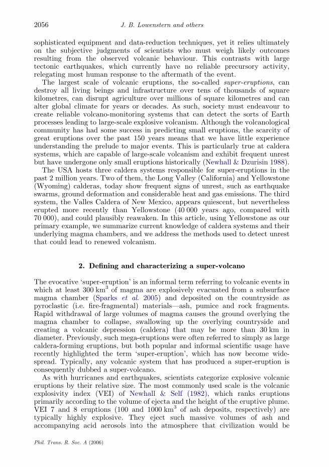
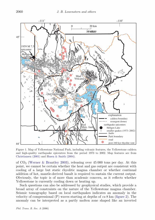
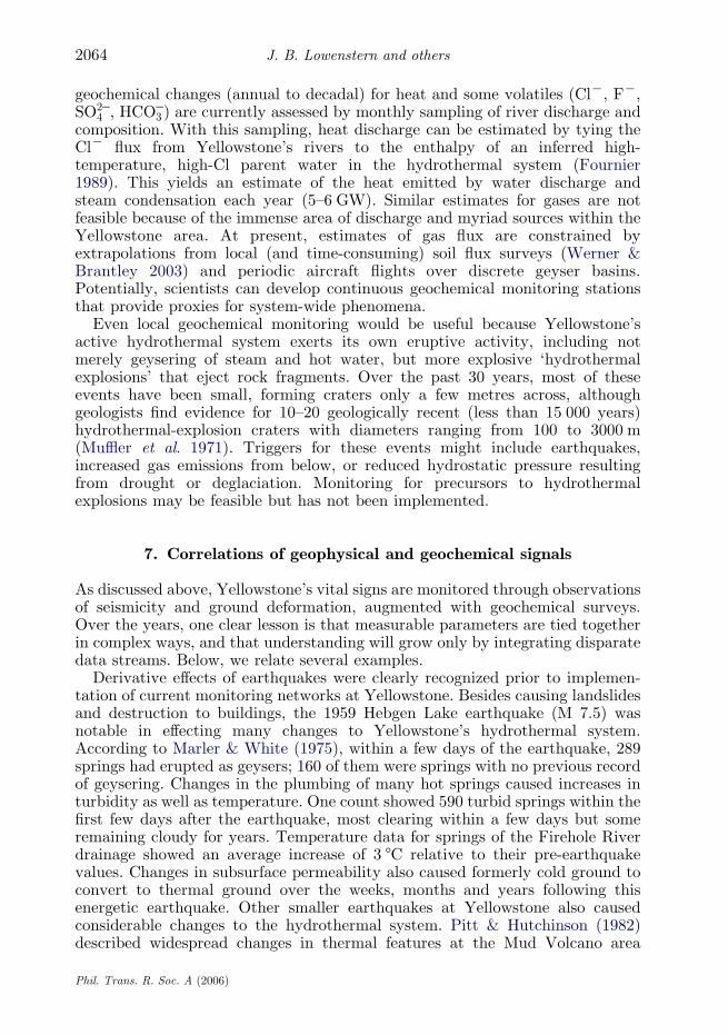
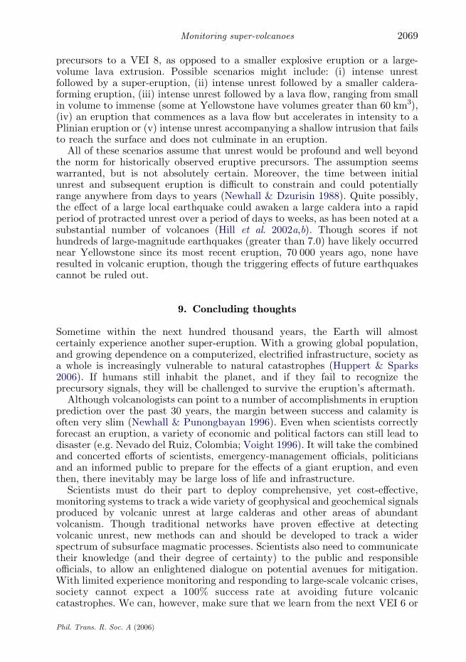
the caldera show linear trends, implying that regional faults still control much ofthe earthquake generation beneath the caldera (figure 1). Moreover, vents forpost-caldera lava flows follow clear linear trends through the central caldera andalong its western margin, parallel to the structural grain of the mountains southof the caldera.
Like many volcanoes, Yellowstone has an active hydrothermal (hot water andsteam) system that resides between the Earth’s surface and the underlyingmagma. Because the Yellowstone Plateau is a high mountainous region, it receivesabundant winter precipitation, much of which recharges the aquifers within thevolcanic rocks. The aquifer intercepts rising heat and gases, forming reactivewaters that interact with subsurface rocks to form solute-rich hydrothermal fluids.These fluids convect beneath the ground surface, precipitating mineral deposits asthey flow. The constant earthquakes and ground movements within the calderacreate new fractures and regions of permeability, which are continually filled bythe migrating fluids. The importance of the hydrothermal system cannot beunderstated, as many of the geochemical and geophysical signals measured at thesurface have hydrothermal origins or magmatic origins modulated by theintervening hydrothermal aquifer.
5. Yellowstone: recognizing the presence of a magma chamber
Owing to Yellowstone’s relatively subdued Rocky Mountain topography and thewidely forested volcanic structures within the park, Yellowstone was thought tobe extinct and was historically overlooked as a volcanic system with eruptivepotential. Though volcanologist Jaggar (1922) recognized Yellowstone’sdynamism (see epigraph above), his ‘mountain’ observatory was not actuallyenvisioned to be a volcano observatory. It was not until the 1960s that thegeological mapping of Robert Christiansen (Christiansen & Blank 1972) revealedthat the Yellowstone country had experienced three, large, explosive eruptionsover the past two million years, accompanied by many other smaller eruptions.In the 1970s, geodetic surveys demonstrated that the central part of theYellowstone caldera had risen 80 cm since the 1920s (Pelton & Smith 1979),primarily around areas that Christiansen & Blank (1972) identified as ‘resurgentdomes’ within the central part of the caldera. Other scientific studiesdocumented the formation of post-glacial hydrothermal-explosion craters,young faults and abundant seismicity. It became clear that Yellowstone wasstill active and posed an unknown risk of future catastrophic eruptions. Toquantify that risk, Earth scientists needed to characterize the size, depth andphysical status of any magma reservoirs still present beneath the surface.
Probably the most convincing evidence for a relatively shallow magma body isthe immense heat flow issuing from Yellowstone on a continual basis. Eventhough fumaroles at Yellowstone have far lower temperatures than at manyvolcanoes, thousands of boiling thermal features dot the landscape and coverabout 70 km2 (out of 9000 km2 in the park). The estimated convective heat flow(more than 75% of the total) is 5–6 GW, averaging ca 2 W mK2 within thecaldera, or roughly 30 times greater than the average continental value (Smith &Braile 1994). Gas flux at Yellowstone is also highly anomalous. Extrapolations ofsoil–gas flux data imply that Yellowstone is one of Earth’s most prolific sources
Phil. Trans. R. Soc. A (2006)
Old FaithfulOld FaithfulOld Faithful
00 20 km
10 MILES10 miles
–111˚ –110˚
45˚
44˚
IDA
HO
WY
OM
ING
MONTANA
MONTANA
IDAHO
IDAHO Yellowstone Yellowstone
Lake Lake
Yellowstone
Lake
Hebgen Lake
1959 M 7.5 epicenter
West WestThumbThumb WestThumb
RedMnts. faultzone
1985 Swarm
1985 Swarm
1985 Swarm
NorrisNorrisNorris
Mud MudVolcanoVolcano
MudVolcano
Caldera Boundary
Dome Dome
Sour Creek
Dome
Dome
Sour Creek
earthquake epicentersHebgen Lake smaller quakes (1973–2002)
faultsPark boundaryroadpost-160 kyr rhyolite vent
caldera boundaryresurgent domes
explanation
Mallard Lake
Figure 1. Map of Yellowstone National Park, including volcanic features, the Yellowstone calderaand high-quality earthquake epicentres from the period 1973 to 2002. Map features are fromChristiansen (2001) and Husen & Smith (2004).
J. B. Lowenstern and others2060
of CO2 (Werner & Brantley 2003), releasing over 45 000 tons per day. At thispoint, we cannot be certain whether the heat and gas output are consistent withcooling of a large but static rhyolitic magma chamber or whether continualaddition of hot, mantle-derived basalt is required to sustain the current output.Obviously, the topic is of more than academic concern, as it reflects whetherYellowstone is currently cooling down or heating up.
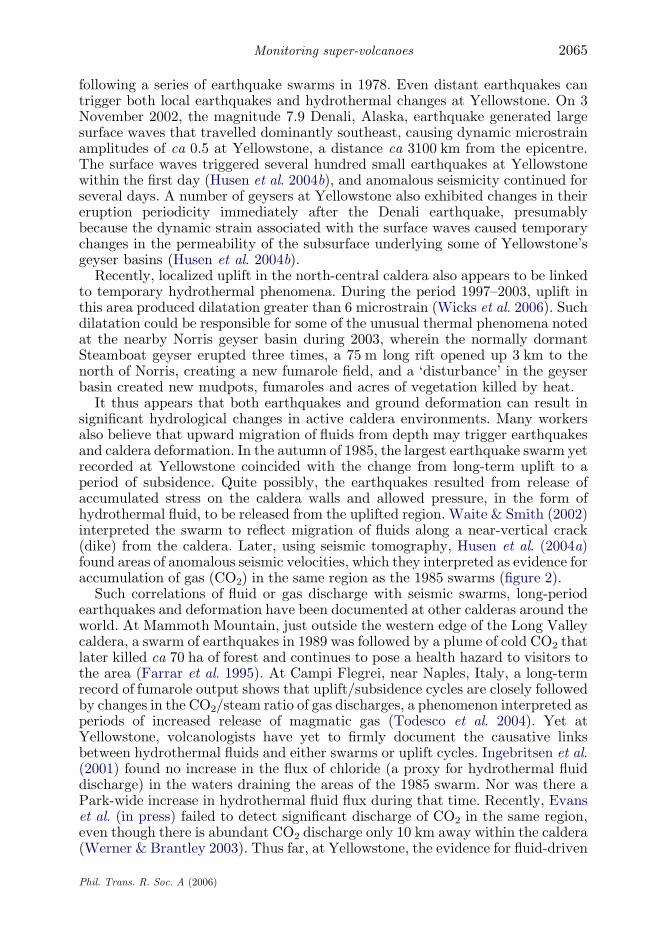
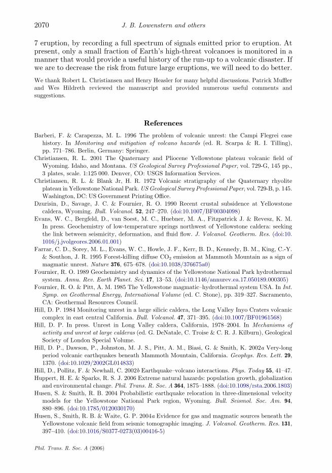
Such questions can also be addressed by geophysical studies, which provide abroad array of constraints on the nature of the Yellowstone magma chamber.Seismic tomography based on local earthquakes indicates an anomaly in thevelocity of compressional (P) waves starting at depths of ca 8 km (figure 2). Theanomaly can be interpreted as a partly molten zone shaped like an inverted
Phil. Trans. R. Soc. A (2006)
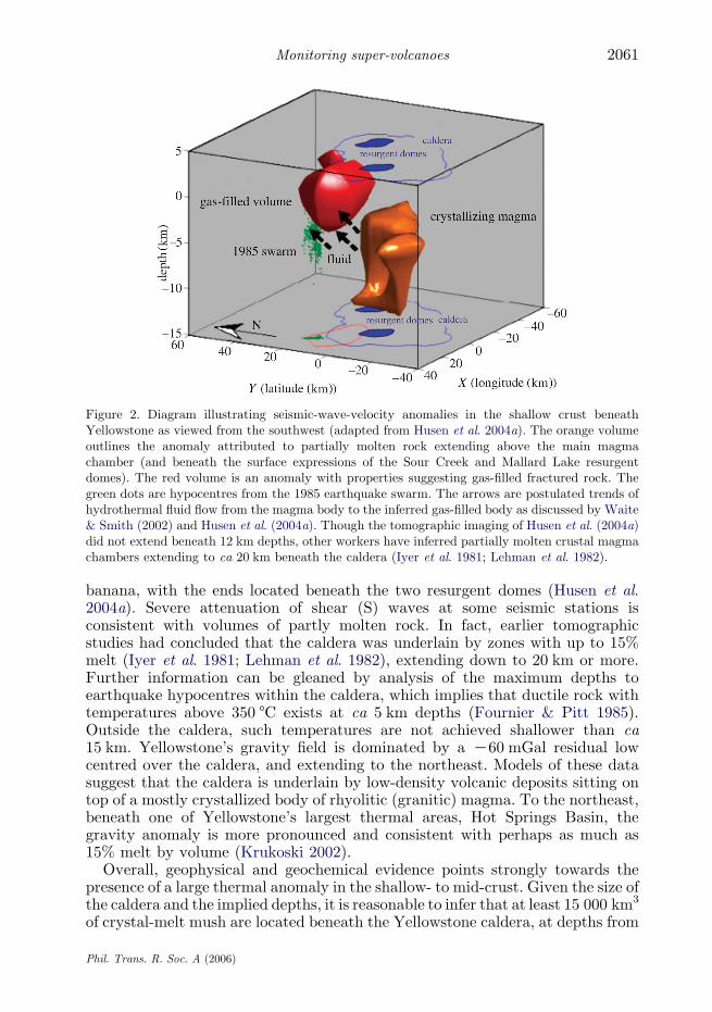
Figure 2. Diagram illustrating seismic-wave-velocity anomalies in the shallow crust beneathYellowstone as viewed from the southwest (adapted from Husen et al. 2004a). The orange volumeoutlines the anomaly attributed to partially molten rock extending above the main magmachamber (and beneath the surface expressions of the Sour Creek and Mallard Lake resurgentdomes). The red volume is an anomaly with properties suggesting gas-filled fractured rock. Thegreen dots are hypocentres from the 1985 earthquake swarm. The arrows are postulated trends ofhydrothermal fluid flow from the magma body to the inferred gas-filled body as discussed by Waite& Smith (2002) and Husen et al. (2004a). Though the tomographic imaging of Husen et al. (2004a)did not extend beneath 12 km depths, other workers have inferred partially molten crustal magmachambers extending to ca 20 km beneath the caldera (Iyer et al. 1981; Lehman et al. 1982).
2061Monitoring super-volcanoes
banana, with the ends located beneath the two resurgent domes (Husen et al.2004a). Severe attenuation of shear (S) waves at some seismic stations isconsistent with volumes of partly molten rock. In fact, earlier tomographicstudies had concluded that the caldera was underlain by zones with up to 15%melt (Iyer et al. 1981; Lehman et al. 1982), extending down to 20 km or more.Further information can be gleaned by analysis of the maximum depths toearthquake hypocentres within the caldera, which implies that ductile rock withtemperatures above 350 8C exists at ca 5 km depths (Fournier & Pitt 1985).Outside the caldera, such temperatures are not achieved shallower than ca15 km. Yellowstone’s gravity field is dominated by a K60 mGal residual lowcentred over the caldera, and extending to the northeast. Models of these datasuggest that the caldera is underlain by low-density volcanic deposits sitting ontop of a mostly crystallized body of rhyolitic (granitic) magma. To the northeast,beneath one of Yellowstone’s largest thermal areas, Hot Springs Basin, thegravity anomaly is more pronounced and consistent with perhaps as much as15% melt by volume (Krukoski 2002).
Overall, geophysical and geochemical evidence points strongly towards thepresence of a large thermal anomaly in the shallow- to mid-crust. Given the size ofthe caldera and the implied depths, it is reasonable to infer that at least 15 000 km3
of crystal-melt mush are located beneath the Yellowstone caldera, at depths from
Phil. Trans. R. Soc. A (2006)
J. B. Lowenstern and others2062
ca 8 to 18 km. If melt fractions are 0.1–0.15, then sufficient melt exists to form themass for a super-eruption—if it can be extracted and accumulated into aneruptible volume. Most geophysical images have insufficient resolution to definevolumes less than ca 10 km on a side. It is fully plausible that volumes with highmelt fractions (more than 0.6) exist within dikes and sills within the greatermagma chamber, and could erupt as moderate-volume (less than 100 km3) lavas orpyroclastic flows. Current evidence suggests, however, that the gravity andseismic anomalies are not sufficiently large to allow for a larger, highly molten (andthereby eruptible) volume of magma beneath Yellowstone at this time.
6. Yellowstone: current activity
Despite Yellowstone’s long period of volcanic dormancy, now over 70 000 years,the caldera continues to be an active and dynamic environment, with thousandsof earthquakes, active ground deformation and considerable heat and mass flux.The monitoring system of the Yellowstone Volcano Observatory (volcanoes.usgs.gov/yvo) is designed to listen to these signals, to see how they relate to eachother, and to provide adequate characterization of background activity. Only bycataloguing the range of normal activity can we start to decipher the signalsemanating from caldera systems headed towards eruption. Here, we now addressthe kinds of Earth signals documented over the past 50 years.
(a ) Earthquakes
Anywhere from 1000 to 3000 detectable earthquakes occur in the Yellowstoneregion during any given year. Almost two-thirds take place in an east–westtrending linear zone connecting Hebgen Lake with the northern rim of theYellowstone caldera (figure 1). The earthquakes appear to be concentrated alongthe trend of the buried ring-fracture system formed during caldera collapseduring the 2.1 million year eruption, and they may be the result of stresstransferred to the area by the magnitude 7.5 Hebgen Lake earthquake in 1959,the largest historical earthquake in the western US interior. Because no seismicnetwork existed in the area prior to the 1970s, it is impossible to confirm if thisarea was comparably seismogenic prior to 1959. Regardless of the reasons for itsactivity, this small zone, outside the Yellowstone caldera, is one of the mostseismogenic areas within the US outside California and Alaska. OtherYellowstone earthquakes occur along linear trends within the caldera, alongfaults south of the caldera and beneath obvious hydrothermal zones, such asgeyser basins. Over one-third of the earthquakes at Yellowstone are related todiscrete swarms of small earthquakes occurring over a localized area over a shortperiod of time (usually 1–2 days). Many of these swarms occur along theeast–west seismogenic zone described above, though many others have occurredwithin the caldera as well as to its south and east. One notable swarm duringthe autumn of 1985 (figure 1) consisted of over 3000 recordable events (up tomagnitude 4.9) over a three-month period in the region extending northwestfrom the west margin of the caldera toward Hebgen Lake (Waite & Smith 2002).In the past 20 years, several swarms have been recorded within the northernpart of Yellowstone Lake, and others near West Thumb, in a north-trending linecolinear with the Red Mountain Fault, which intersects the southern boundary
Phil. Trans. R. Soc. A (2006)
2063Monitoring super-volcanoes
of the caldera. Earthquake swarms are a common mode of seismic energy releaseat Yellowstone and other caldera systems. At stratovolcanoes, swarms areusually interpreted as a sign of unrest, plausibly leading towards eruption, or atleast indicating a subsurface episode of magma intrusion. Nonetheless, swarmsare also recorded along faults in areas far removed from active volcanism. Inview of the profound regional tectonism and extension, the lingering effects fromthe magnitude 7.5 Hebgen Lake earthquake, and the considerable intra-calderadeformation, swarms at Yellowstone may well reflect a variety of causativemechanisms.
At the Long Valley caldera, which formed during a super-eruption 760 000years ago, scientists have recorded long-period and very-long-period volcanicearthquakes that apparently reflect the movements of slugs of magmatic orhydrothermal fluids at depths ranging from 3 to more than 30 km (Hill et al.2002a,b). Deep, long-period earthquakes have been documented at a variety ofvolcanic settings, usually during periods of inferred magma recharge at mid- tolower-crustal levels. At Yellowstone, however, such events have never beenidentified. It is unclear whether they are completely absent or whether they aretoo subtle to be detected by the existing seismic network.
(b ) Deformation
Since recognizing that the Yellowstone region actively rises and subsides withtime, scientists have used a variety of techniques such as levelling, the globalpositioning system (GPS) and most recently interferometric synthetic apertureradar (InSAR) to map out spatial-temporal deformation patterns. Subsequent tothe ca 80 cm of uplift measured prior to 1985, workers noted the onset ofsubsidence within the caldera that persisted through the mid-1990s. In the late1990s, deformation data showed that the two resurgent domes could operateindependently, with one subsiding while the other rose or did nothing (Wickset al. 1998). Today, we know that uplift can occur at other locations in andaround the caldera, as both GPS and InSAR data reveal that between 1997 and2003, the north-central caldera underwent a maximum of ca 12 cm of uplift,while the resurgent domes subsided (Wicks et al. 2006). Deformation then shiftedto the resurgent domes, which began to rise again, with more than 8 cm ofupward movement recorded by continuous GPS stations between late 2004 andthe present time (early 2006). Geological studies of lake terraces strongly suggestthat uplift/subsidence cycles of deformation at Yellowstone have taken placethroughout the Holocene (less than ca 11 000 years) with localities near theoutlet of Yellowstone Lake (between the resurgent domes) changing elevation bymore than 3 m (Pierce et al. 2002). The principal mechanism of the deformationis speculated to be either magma intrusion, or migration of hydrothermal fluids,such as brines or gas. Without time-series monitoring of geochemical proxies thatmight track with uplift/subsidence, however, it remains difficult to corroborateany particular mechanism.
(c ) Hydrothermal
At present, we have adequate estimates of the enormous long-term dischargeof heat and gas at Yellowstone, but we have no system for monitoring temporalchanges in heat and mass output other than on an annual basis. Long-term
Phil. Trans. R. Soc. A (2006)
J. B. Lowenstern and others2064
geochemical changes (annual to decadal) for heat and some volatiles (ClK, FK,SO2K
4 , HCOK3 ) are currently assessed by monthly sampling of river discharge and
composition. With this sampling, heat discharge can be estimated by tying theClK flux from Yellowstone’s rivers to the enthalpy of an inferred high-temperature, high-Cl parent water in the hydrothermal system (Fournier1989). This yields an estimate of the heat emitted by water discharge andsteam condensation each year (5–6 GW). Similar estimates for gases are notfeasible because of the immense area of discharge and myriad sources within theYellowstone area. At present, estimates of gas flux are constrained byextrapolations from local (and time-consuming) soil flux surveys (Werner &Brantley 2003) and periodic aircraft flights over discrete geyser basins.Potentially, scientists can develop continuous geochemical monitoring stationsthat provide proxies for system-wide phenomena.
Even local geochemical monitoring would be useful because Yellowstone’sactive hydrothermal system exerts its own eruptive activity, including notmerely geysering of steam and hot water, but more explosive ‘hydrothermalexplosions’ that eject rock fragments. Over the past 30 years, most of theseevents have been small, forming craters only a few metres across, althoughgeologists find evidence for 10–20 geologically recent (less than 15 000 years)hydrothermal-explosion craters with diameters ranging from 100 to 3000 m(Muffler et al. 1971). Triggers for these events might include earthquakes,increased gas emissions from below, or reduced hydrostatic pressure resultingfrom drought or deglaciation. Monitoring for precursors to hydrothermalexplosions may be feasible but has not been implemented.
7. Correlations of geophysical and geochemical signals
As discussed above, Yellowstone’s vital signs are monitored through observationsof seismicity and ground deformation, augmented with geochemical surveys.Over the years, one clear lesson is that measurable parameters are tied togetherin complex ways, and that understanding will grow only by integrating disparatedata streams. Below, we relate several examples.
Derivative effects of earthquakes were clearly recognized prior to implemen-tation of current monitoring networks at Yellowstone. Besides causing landslidesand destruction to buildings, the 1959 Hebgen Lake earthquake (M 7.5) wasnotable in effecting many changes to Yellowstone’s hydrothermal system.According to Marler & White (1975), within a few days of the earthquake, 289springs had erupted as geysers; 160 of them were springs with no previous recordof geysering. Changes in the plumbing of many hot springs caused increases inturbidity as well as temperature. One count showed 590 turbid springs within thefirst few days after the earthquake, most clearing within a few days but someremaining cloudy for years. Temperature data for springs of the Firehole Riverdrainage showed an average increase of 3 8C relative to their pre-earthquakevalues. Changes in subsurface permeability also caused formerly cold ground toconvert to thermal ground over the weeks, months and years following thisenergetic earthquake. Other smaller earthquakes at Yellowstone also causedconsiderable changes to the hydrothermal system. Pitt & Hutchinson (1982)described widespread changes in thermal features at the Mud Volcano area
Phil. Trans. R. Soc. A (2006)
2065Monitoring super-volcanoes
following a series of earthquake swarms in 1978. Even distant earthquakes cantrigger both local earthquakes and hydrothermal changes at Yellowstone. On 3November 2002, the magnitude 7.9 Denali, Alaska, earthquake generated largesurface waves that travelled dominantly southeast, causing dynamic microstrainamplitudes of ca 0.5 at Yellowstone, a distance ca 3100 km from the epicentre.The surface waves triggered several hundred small earthquakes at Yellowstonewithin the first day (Husen et al. 2004b), and anomalous seismicity continued forseveral days. A number of geysers at Yellowstone also exhibited changes in theireruption periodicity immediately after the Denali earthquake, presumablybecause the dynamic strain associated with the surface waves caused temporarychanges in the permeability of the subsurface underlying some of Yellowstone’sgeyser basins (Husen et al. 2004b).
Recently, localized uplift in the north-central caldera also appears to be linkedto temporary hydrothermal phenomena. During the period 1997–2003, uplift inthis area produced dilatation greater than 6 microstrain (Wicks et al. 2006). Suchdilatation could be responsible for some of the unusual thermal phenomena notedat the nearby Norris geyser basin during 2003, wherein the normally dormantSteamboat geyser erupted three times, a 75 m long rift opened up 3 km to thenorth of Norris, creating a new fumarole field, and a ‘disturbance’ in the geyserbasin created new mudpots, fumaroles and acres of vegetation killed by heat.
It thus appears that both earthquakes and ground deformation can result insignificant hydrological changes in active caldera environments. Many workersalso believe that upward migration of fluids from depth may trigger earthquakesand caldera deformation. In the autumn of 1985, the largest earthquake swarm yetrecorded at Yellowstone coincided with the change from long-term uplift to aperiod of subsidence. Quite possibly, the earthquakes resulted from release ofaccumulated stress on the caldera walls and allowed pressure, in the form ofhydrothermal fluid, to be released from the uplifted region. Waite & Smith (2002)interpreted the swarm to reflect migration of fluids along a near-vertical crack(dike) from the caldera. Later, using seismic tomography, Husen et al. (2004a)found areas of anomalous seismic velocities, which they interpreted as evidence foraccumulation of gas (CO2) in the same region as the 1985 swarms (figure 2).
Such correlations of fluid or gas discharge with seismic swarms, long-periodearthquakes and deformation have been documented at other calderas around theworld. At Mammoth Mountain, just outside the western edge of the Long Valleycaldera, a swarm of earthquakes in 1989 was followed by a plume of cold CO2 thatlater killed ca 70 ha of forest and continues to pose a health hazard to visitors tothe area (Farrar et al. 1995). At Campi Flegrei, near Naples, Italy, a long-termrecord of fumarole output shows that uplift/subsidence cycles are closely followedby changes in the CO2/steam ratio of gas discharges, a phenomenon interpreted asperiods of increased release of magmatic gas (Todesco et al. 2004). Yet atYellowstone, volcanologists have yet to firmly document the causative linksbetween hydrothermal fluids and either swarms or uplift cycles. Ingebritsen et al.(2001) found no increase in the flux of chloride (a proxy for hydrothermal fluiddischarge) in the waters draining the areas of the 1985 swarm. Nor was there aPark-wide increase in hydrothermal fluid flux during that time. Recently, Evanset al. (in press) failed to detect significant discharge of CO2 in the same region,even though there is abundant CO2 discharge only 10 km away within the caldera(Werner & Brantley 2003). Thus far, at Yellowstone, the evidence for fluid-driven
Phil. Trans. R. Soc. A (2006)
J. B. Lowenstern and others2066
‘unrest’ is inferred from geophysics rather than geochemistry, though this partlyreflects the minimal geochemical network that currently exists. It is clear, though,that before we can reliably forecast impending activity at Yellowstone and theworld’s other large caldera systems, we need to monitor a diverse collection ofvolcanic signals at high temporal resolution.
8. Recognition of unrest at large calderas
Yellowstone is an active magmatic system emitting a variety of signals related totectonic, magmatic and hydrothermal processes. The challenge to volcanologistsremains to identify those unrest patterns that are potential indicators ofimpending eruption. Below, we briefly discuss some examples of unrest at largecalderas during the past 30–40 years of volcano monitoring, and the challengesthat volcanologists face in recognizing calderas headed toward eruption.
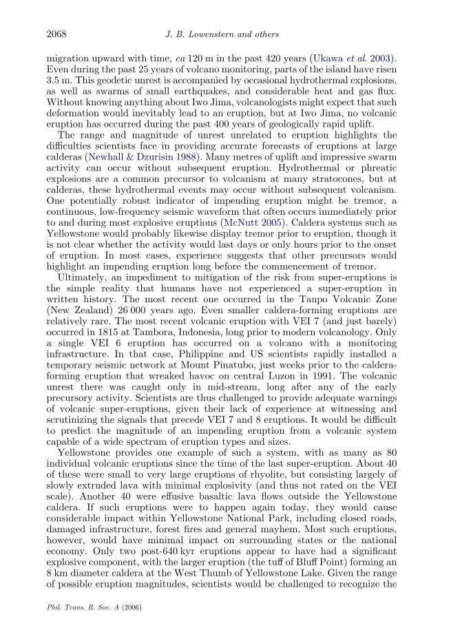
At Long Valley caldera, unrest in 1980 began with four M 6.0 earthquakessouth of the caldera, three of which occurred on the same day. Scientists quicklymeasured the area for deformation and found evidence for over 20 cm of upliftwithin the caldera since the previous summer (Hill 1984). By 2006, the calderahas experienced nearly 80 cm of intermittent uplift (table 1), as well as over 1100earthquakes over M 3.0 (about twice as many as Yellowstone). Subsequentunrest episodes of note included (i) an intense earthquake swarm in January 1983with two M 5.2 earthquakes accompanied by a 7 cm uplift of the resurgent dome,(ii) an 11-month-long swarm that began in April 1989 beneath MammothMountain, a 50 kyr volcano on the southwest caldera rim, accompanied by theonset of CO2 emissions that persist today and (iii) a six-month-long swarmduring the last half of 1997 that included nine MO4 earthquakes and anadditional 10 cm uplift of the resurgent dome. Intervening activity from 1981 to1999 was characterized by recurring moderate earthquake swarms, gradualinflation of the resurgent dome at varying rates, as well as both mid-crustal long-period earthquakes and shallow very-long-period earthquakes beneath and westof Mammoth Mountain. Only minor unrest has occurred in Long Valley calderasince 2000 with the resurgent dome maintaining its ca 80 cm elevation increaseaccumulated during the 1980–1999 unrest (Hill in press).
The crustal movements of Campi Flegrei, located just northwest of Naples,Italy, are better documented than any other post-caldera system. Since Romantimes, the region has famously swelled and subsided with relatively littleearthquake activity. After the most recent eruption at Campi Flegrei in 1538,the city of Pozzuoli, within the caldera, subsided continuously until 1968, when itcommenced 2.5 m of uplift in two episodes over the next 17 years. Pozzuoli rose ca1.8 m between 1982 and 1984 and was rocked by numerous swarms of smallearthquakes, causing considerable consternation of the local populace. Officialsevacuated 40 000 people, but considered evacuating ca 200 000 more, thougheventually the caldera ceased swelling and once again began to subside (Barberi &Carapezza 1996).
The most extreme example of post-caldera deformation occurs on the island ofIwo Jima, in the Volcano Islands 1200 km south of Tokyo. The island representsthe resurgent dome of a caldera apparently formed 3000 years ago during a largepyroclastic eruption. A series of wavecut terraces preserves a record of the island’s
Phil. Trans. R. Soc. A (2006)

Table
1.Examplesofcaldera-deform
ationepisodes
andtheirrates.(C
/K,upliftorsubsidence;t,durationofevent;d,amountofuplift;rate,rate
of
uplift;eruption,did
thedeform
ationculm
inate
inaneruption(yet)?)
caldera
C/K
time(commonera)
t(years)
d(m
)rate
(myrK
1)
eruption?
reference
IwoJim
aC
1600–2000
400
120.0
0.30
no
Yokoyama&
Nazzarro(2002)
IwoJim
aC
1911–1978
67
10.0
0.15
no
Yokoyama&
Nazzarro(2002)
CampiFlegrei
KK200–1000
1200
12.0
0.01
no
Yokoyama&
Nazzarro(2002)
CampiFlegrei
Cw1538
w20
6.0
0.30
yes
Yokoyama&
Nazzarro(2002)
CampiFlegrei
C1983–1985
21.5
0.75
no
Yokoyama&
Nazzarro(2002)
LongValley
C1980–2000
20
0.8
0.04
no
Hill(inpress)
Rabaul
C1974–1984
10
1.5
0.15
yes
aMcK
eeet
al.(1984)
Yellowstone
C1925–1985
60
0.8
0.013
no
Dzurisinet
al.(1990)
Yellowstone
K1985–1995
10
0.14
0.014
no
Waite&
Smith(2002)
Yellowstone
C2005
10.1
0.1
no
http://volcanoes.usgs.gov/yvo
aRabauleruptionin
1994.
2067Monitoring super-volcanoes
Phil. Trans. R. Soc. A (2006)
J. B. Lowenstern and others2068
migration upward with time, ca 120 m in the past 420 years (Ukawa et al. 2003).Even during the past 25 years of volcano monitoring, parts of the island have risen3.5 m. This geodetic unrest is accompanied by occasional hydrothermal explosions,as well as swarms of small earthquakes, and considerable heat and gas flux.Without knowing anything about Iwo Jima, volcanologists might expect that suchdeformation would inevitably lead to an eruption, but at Iwo Jima, no volcaniceruption has occurred during the past 400 years of geologically rapid uplift.
The range and magnitude of unrest unrelated to eruption highlights thedifficulties scientists face in providing accurate forecasts of eruptions at largecalderas (Newhall & Dzurisin 1988). Many metres of uplift and impressive swarmactivity can occur without subsequent eruption. Hydrothermal or phreaticexplosions are a common precursor to volcanism at many stratocones, but atcalderas, these hydrothermal events may occur without subsequent volcanism.One potentially robust indicator of impending eruption might be tremor, acontinuous, low-frequency seismic waveform that often occurs immediately priorto and during most explosive eruptions (McNutt 2005). Caldera systems such asYellowstone would probably likewise display tremor prior to eruption, though itis not clear whether the activity would last days or only hours prior to the onsetof eruption. In most cases, experience suggests that other precursors wouldhighlight an impending eruption long before the commencement of tremor.
Ultimately, an impediment to mitigation of the risk from super-eruptions isthe simple reality that humans have not experienced a super-eruption inwritten history. The most recent one occurred in the Taupo Volcanic Zone(New Zealand) 26 000 years ago. Even smaller caldera-forming eruptions arerelatively rare. The most recent volcanic eruption with VEI 7 (and just barely)occurred in 1815 at Tambora, Indonesia, long prior to modern volcanology. Onlya single VEI 6 eruption has occurred on a volcano with a monitoringinfrastructure. In that case, Philippine and US scientists rapidly installed atemporary seismic network at Mount Pinatubo, just weeks prior to the caldera-forming eruption that wreaked havoc on central Luzon in 1991. The volcanicunrest there was caught only in mid-stream, long after any of the earlyprecursory activity. Scientists are thus challenged to provide adequate warningsof volcanic super-eruptions, given their lack of experience at witnessing andscrutinizing the signals that precede VEI 7 and 8 eruptions. It would be difficultto predict the magnitude of an impending eruption from a volcanic systemcapable of a wide spectrum of eruption types and sizes.
Yellowstone provides one example of such a system, with as many as 80individual volcanic eruptions since the time of the last super-eruption. About 40of these were small to very large eruptions of rhyolite, but consisting largely ofslowly extruded lava with minimal explosivity (and thus not rated on the VEIscale). Another 40 were effusive basaltic lava flows outside the Yellowstonecaldera. If such eruptions were to happen again today, they would causeconsiderable impact within Yellowstone National Park, including closed roads,damaged infrastructure, forest fires and general mayhem. Most such eruptions,however, would have minimal impact on surrounding states or the nationaleconomy. Only two post-640 kyr eruptions appear to have had a significantexplosive component, with the larger eruption (the tuff of Bluff Point) forming an8 km diameter caldera at the West Thumb of Yellowstone Lake. Given the rangeof possible eruption magnitudes, scientists would be challenged to recognize the
Phil. Trans. R. Soc. A (2006)
2069Monitoring super-volcanoes
precursors to a VEI 8, as opposed to a smaller explosive eruption or a large-volume lava extrusion. Possible scenarios might include: (i) intense unrestfollowed by a super-eruption, (ii) intense unrest followed by a smaller caldera-forming eruption, (iii) intense unrest followed by a lava flow, ranging from smallin volume to immense (some at Yellowstone have volumes greater than 60 km3),(iv) an eruption that commences as a lava flow but accelerates in intensity to aPlinian eruption or (v) intense unrest accompanying a shallow intrusion that failsto reach the surface and does not culminate in an eruption.
All of these scenarios assume that unrest would be profound and well beyondthe norm for historically observed eruptive precursors. The assumption seemswarranted, but is not absolutely certain. Moreover, the time between initialunrest and subsequent eruption is difficult to constrain and could potentiallyrange anywhere from days to years (Newhall & Dzurisin 1988). Quite possibly,the effect of a large local earthquake could awaken a large caldera into a rapidperiod of protracted unrest over a period of days to weeks, as has been noted at asubstantial number of volcanoes (Hill et al. 2002a,b). Though scores if nothundreds of large-magnitude earthquakes (greater than 7.0) have likely occurrednear Yellowstone since its most recent eruption, 70 000 years ago, none haveresulted in volcanic eruption, though the triggering effects of future earthquakescannot be ruled out.
9. Concluding thoughts
Sometime within the next hundred thousand years, the Earth will almostcertainly experience another super-eruption. With a growing global population,and growing dependence on a computerized, electrified infrastructure, society asa whole is increasingly vulnerable to natural catastrophes (Huppert & Sparks2006). If humans still inhabit the planet, and if they fail to recognize theprecursory signals, they will be challenged to survive the eruption’s aftermath.
Although volcanologists can point to a number of accomplishments in eruptionprediction over the past 30 years, the margin between success and calamity isoften very slim (Newhall & Punongbayan 1996). Even when scientists correctlyforecast an eruption, a variety of economic and political factors can still lead todisaster (e.g. Nevado del Ruiz, Colombia; Voight 1996). It will take the combinedand concerted efforts of scientists, emergency-management officials, politiciansand an informed public to prepare for the effects of a giant eruption, and eventhen, there inevitably may be large loss of life and infrastructure.
Scientists must do their part to deploy comprehensive, yet cost-effective,monitoring systems to track a wide variety of geophysical and geochemical signalsproduced by volcanic unrest at large calderas and other areas of abundantvolcanism. Though traditional networks have proven effective at detectingvolcanic unrest, new methods can and should be developed to track a widerspectrum of subsurface magmatic processes. Scientists also need to communicatetheir knowledge (and their degree of certainty) to the public and responsibleofficials, to allow an enlightened dialogue on potential avenues for mitigation.With limited experience monitoring and responding to large-scale volcanic crises,society cannot expect a 100% success rate at avoiding future volcaniccatastrophes. We can, however, make sure that we learn from the next VEI 6 or
Phil. Trans. R. Soc. A (2006)
J. B. Lowenstern and others2070
7 eruption, by recording a full spectrum of signals emitted prior to eruption. Atpresent, only a small fraction of Earth’s high-threat volcanoes is monitored in amanner that would provide a useful history of the run-up to a volcanic disaster. Ifwe are to decrease the risk from future large eruptions, we will need to do better.
We thank Robert L. Christiansen and Henry Heasler for many helpful discussions. Patrick Muffler
and Wes Hildreth reviewed the manuscript and provided numerous useful comments and
suggestions.
References
Barberi, F. & Carapezza, M. L. 1996 The problem of volcanic unrest: the Campi Flegrei case
history. In Monitoring and mitigation of volcano hazards (ed. R. Scarpa & R. I. Tilling),
pp. 771–786. Berlin, Germany: Springer.
Christiansen, R. L. 2001 The Quaternary and Pliocene Yellowstone plateau volcanic field of
Wyoming. Idaho, and Montana. US Geological Survey Professional Paper, vol. 729-G, 145 pp.,
3 plates, scale. 1:125 000. Denver, CO: USGS Information Services.
Christiansen, R. L. & Blank Jr, H. R. 1972 Volcanic stratigraphy of the Quaternary rhyolite
plateau in Yellowstone National Park.USGeological Survey Professional Paper, vol. 729-B, p. 145.
Washington, DC: US Government Printing Office.
Dzurisin, D., Savage, J. C. & Fournier, R. O. 1990 Recent crustal subsidence at Yellowstone
caldera, Wyoming. Bull. Volcanol. 52, 247–270. (doi:10.1007/BF00304098)
Evans, W. C., Bergfeld, D., van Soest, M. C., Huebner, M. A., Fitzpatrick J. & Revesz, K. M.
In press. Geochemistry of low-temperature springs northwest of Yellowstone caldera: seeking
the link between seismicity, deformation, and fluid flow. J. Volcanol. Geotherm. Res. (doi:10.
1016/j.jvolgeores.2006.01.001)
Farrar, C. D., Sorey, M. L., Evans, W. C., Howle, J. F., Kerr, B. D., Kennedy, B. M., King, C.-Y.
& Southon, J. R. 1995 Forest-killing diffuse CO2 emission at Mammoth Mountain as a sign of
magmatic unrest. Nature 376, 675–678. (doi:10.1038/376675a0)
Fournier, R. O. 1989 Geochemistry and dynamics of the Yellowstone National Park hydrothermal
system. Annu. Rev. Earth Planet. Sci. 17, 13–53. (doi:10.1146/annurev.ea.17.050189.000305)
Fournier, R. O. & Pitt, A. M. 1985 The Yellowstone magmatic–hydrothermal system USA. In Int.
Symp. on Geothermal Energy, International Volume (ed. C. Stone), pp. 319–327. Sacramento,
CA: Geothermal Resources Council.
Hill, D. P. 1984 Monitoring unrest in a large silicic caldera, the Long Valley Inyo Craters volcanic
complex in east central California. Bull. Volcanol. 47, 371–395. (doi:10.1007/BF01961568)
Hill, D. P. In press. Unrest in Long Valley caldera, California, 1978–2004. In Mechanisms of
activity and unrest at large calderas (ed. G. DeNatale, C. Troise & C. R. J. Kilburn), Geological
Society of London Special Volume.
Hill, D. P., Dawson, P., Johnston, M. J. S., Pitt, A. M., Biasi, G. & Smith, K. 2002a Very-long
period volcanic earthquakes beneath Mammoth Mountain, California. Geophys. Res. Lett. 29,
1370. (doi:10.1029/2002GL014833)
Hill, D., Pollitz, F. & Newhall, C. 2002b Earthquake–volcano interactions. Phys. Today 55, 41–47.
Huppert, H. E. & Sparks, R. S. J. 2006 Extreme natural hazards: population growth, globalization
and environmental change. Phil. Trans. R. Soc. A 364, 1875–1888. (doi:10.1098/rsta.2006.1803)
Husen, S. & Smith, R. B. 2004 Probabilistic earthquake relocation in three-dimensional velocity
models for the Yellowstone National Park region, Wyoming. Bull. Seismol. Soc. Am. 94,
880–896. (doi:10.1785/0120030170)
Husen, S., Smith, R. B. & Waite, G. P. 2004a Evidence for gas and magmatic sources beneath the
Yellowstone volcanic field from seismic tomographic imaging. J. Volcanol. Geotherm. Res. 131,
397–410. (doi:10.1016/S0377-0273(03)00416-5)
Phil. Trans. R. Soc. A (2006)
2071Monitoring super-volcanoes
Husen, S., Taylor, R., Smith, R. B. & Heasler, H. 2004b Changes in geyser behavior and remotely
triggered seismicity in Yellowstone National Park produced by the 2002 M 7.9 Denali fault
earthquake, Alaska. Geology 32, 537–540. (doi:10.1130/G20381.1)
Ingebritsen, S. E., Galloway, D. L., Colvard, E. M., Sorey, M. L. & Mariner, R. H. 2001 Time-
variation of hydrothermal discharge at selected sites in the western United States: implications
for monitoring. J. Volcanol. Geotherm. Res. 111, 1–23. (doi:10.1016/S0377-0273(01)00207-4)
Iyer, H. M., Evans, J. R., Zandt, G., Stewart, R. M., Coakley, J. M. & Roloff, J. N. 1981 A deep
low-velocity body under the Yellowstone caldera, Wyoming: delineation using teleseismic
P-wave residuals and tectonic interpretation: summary. Geol. Soc. Am. Bull. 92, 792–798.
(doi:10.1130/0016-7606(1981)92!792:ADLBUTO2.0.CO;2)
Jaggar, T. A. 1922 A plea for geophysical and geochemical observatories. J. Wash. Acad. Sci. 12,
343–353.
Krukoski, J. C. 2002 A geologic data base (GeoGIS) and three-dimensional inversion for the
density structure of the Yellowstone volcanic system. M.S. thesis, University of Utah, 96 pp.
Lehman, J. A., Smith, R. B., Schilly, M. M. & Braile, L. W. 1982 Upper crustal structure of the
Yellowstone caldera from delay time analyses and gravity correlations. J. Geophys. Res. 87,
2713–2730.
Marler, G. D. & White, D. E. 1975 Seismic geyser and its bearing on the origin and evolution of
geysers and hot springs of Yellowstone National Park. Geol. Soc. Am. Bull. 86, 749–759. (doi:10.
1130/0016-7606(1975)86!749:SGAIBOO2.0.CO;2)
Mason, B., Pyle, D. M. & Oppenheimer, C. 2004 The size and frequency of the largest explosive
eruptions on Earth. Bull. Volcanol. 66, 735–748. (doi:10.1007/s00445-004-0355-9)
McKee, C. O., Lowenstein, P. L., De Saint Ours, P., Talai, B., Itikarai, I. & Mori, J. J. 1984
Seismic and ground deformation crises at Rabaul caldera: prelude to an eruption? Bull.
Volcanol. 47, 397–411. (doi:10.1007/BF01961569)
McNutt, S. R. 2005 Volcano seismology. Annu. Rev. Earth Planet. Sci. 32, 461–491. (doi:10.1146/
annurev.earth.33.092203.122459)
Muffler, L. J. P., White, D. E. & Trusdell, A. H. 1971 Hydrothermal explosion craters in
Yellowstone National Park. Geol. Soc. Am. Bull. 82, 723–740.
Newhall, C. G. & Dzurisin, D. 1988 Historical unrest at large calderas of the world. US Geol. Surv.
Bull. 1855, 1108.
Newhall, C. G. & Punongbayan, R. S. 1996 The narrow margin of successful volcanic-risk
mitigation. In Monitoring and mitigation of volcano hazards (ed. R. Scarpa & R. I. Tilling),
pp. 807–838. Berlin, Germany: Springer.
Newhall, C. G. & Self, S. 1982 The volcanic explosivity index (VEI): an estimate of explosive
magnitude for historical volcanism. J. Geophys. Res. 87, 1231–1238.
Pelton, J. R. & Smith, R. B. 1979 Recent crustal uplift in Yellowstone National Park. Science 206,
1179–1182.
Perkins, M. E. & Nash, B. P. 2002 Explosive silicic volcanism of the Yellowstone hotspot: the ash-
fall tuff record. Geol. Soc. Am. Bull. 114, 367–381. (doi:10.1130/0016-7606(2002)114!0367:
ESVOTYO2.0.CO;2)
Pierce, K. L. & Morgan, L. A. 1992 The track of the Yellowstone hot spot: volcanism, faulting, and
uplift. In Regional geology of eastern Idaho and western Wyoming, vol. 179 (ed. P. K. Link,
M. A. Kuntz & L. B. Platt). Geological Society of America Memoirs, pp. 1–53. Boulder, CO:
Geological Society of America.
Pierce, K. L., Cannon, K. P., Meyer, G. A., Trebesch, M. J. & Watts, R. 2002 Post-glacial
inflation–deflation cycles, tilting and faulting in the Yellowstone caldera based on Yellowstone
Lake shorelines. US Geological Survey Open-File Report 02-0142, 62 pp.
Pitt, A. M. & Hutchinson, R. A. 1982 Hydrothermal changes related to earthquake activity at Mud
Volcano, Yellowstone National Park, Wyoming. J. Geophys. Res. 87, 2762–2766.
Self, S. 2006 The effects and consequences of very large explosive volcanic eruptions. Phil. Trans.
R. Soc. A. 364, 2073–2097. (doi:10.1098/rsta.2006.1814)
Phil. Trans. R. Soc. A (2006)
J. B. Lowenstern and others2072
Smith, R. B. & Braile, L. W. 1994 The Yellowstone hotspot. J. Volcanol. Geotherm. Res. 61,121–187. (doi:10.1016/0377-0273(94)90002-7)
Smith, R. B. & Siegel, L. 2000 Windows into the Earth: the geology of Yellowstone and GrandTeton National Parks, p. 247. Oxford, UK: Oxford University Press.
Sparks, R. S. J., Self, S., Grattan, J., Oppenheimer, C., Pyle, D. & Rymer, H. 2005 Super-eruptions: global effects and future threats. Report of a Geological Society of London WorkingGroup, 25 pp.
Todesco, M., Rutqvist, J., Chiodini, G., Pruess, K. & Oldenburg, C. M. 2004 Modeling of recentvolcanic episodes at Phlegrean Fields (Italy); geochemical variations and ground deformation.Geothermics 33, 531–547. (doi:10.1016/j.geothermics.2003.08.014)
Ukawa, U. M., Fujita, E., Hill, D., Kobayashi, T., Lowenstern, J. & Newhall, C. 2003 Newobservations at Iwo-Jima caldera, Volcano Islands, Japan (abs.). Trans. Eur. Geophys. UnionNice, France.
Voight, B. 1996 The management of volcano emergencies: Nevado del Ruiz. In Monitoring andmitigation of Volcano hazards (ed. R. Scarpa & R. I. Tilling), pp. 719–769. Berlin, Germany:Springer.
Waite, G. P. & Smith, R. B. 2002 Seismic evidence for fluid migration accompanying subsidence ofthe Yellowstone caldera. J. Geophys. Res. 107, 2177–2192. (doi:10.1029/2001JB000586)
Werner, C. & Brantley, S. 2003 CO2 emissions from the Yellowstone volcanic system. Geochem.Geophys. Geosyst. 4, 27. (doi:10.1029/2002GC000473)
Wicks, C., Thatcher, W. & Dzurisin, D. 1998 Migration of fluids beneath Yellowstone calderainferred from satellite radar interferometry. Science 282, 458–462. (doi:10.1126/science.282.5388.458)
Wicks, C., Thatcher, W., Dzurisin, D. & Svarc, J. 2006 Uplift, thermal unrest, and magmaintrusion at Yellowstone caldera. Nature 440, 72–75. (doi:10.1038/nature04507)
Wilson, C. & Hildreth, W. 1997 Assembling an ignimbrite: mechanical and thermal building blocksin the Bishop Tuff, California. J. Geol. 111, 653–670. (doi:10.1086/378335)
Yokoyama, I. & Nazzaro, A. 2002 Anomalous crustal movements with low seismic efficiency—Campi Flegrei, Italy and some examples in Japan. Ann. Geophys. 45, 709–722.
Phil. Trans. R. Soc. A (2006)