Embed Size (px)
Citation preview

FINAL REPORT
PROJECT ID NUMBER: T-24, 9001 204 6227 PROJECT TITLE: The Cooperative Conservation Blueprint
Phase III: Regional Pilot PROJECT DIRECTOR: Brian Branciforte, Florida Fish and
Wildlife Conservation Commission
PROJECT DURATION: January 1, 2011 – December 15, 2014 DATE REPORT SUBMITTED: February 2015

i
ABSTRACT The goal of the Cooperative Conservation Blueprint (Blueprint), a major multi-partner initiative led by the Florida Fish and Wildlife Conservation Commission (FWC), is to conserve the state’s essential and signature working and natural lands and integral water resources for future generations. The regional pilot was an important strategic step in advancing the Blueprint. It tested and further refined core Blueprint tools and demonstrated how the Blueprint can be used as a framework for decisions that over time will sustain the natural resources and working agricultural landscapes it highlights. The 13-county southwest and south central Florida pilot region (Appendix 1) extends from the Big Cypress National Preserve north to the upper reaches of the Peace and Kissimmee rivers. That area was chosen because of its extensive natural resources that provide important wildlife habitat and water resource functions and are still held by relatively few landowners. Also considered was the opportunity to build on numerous other conservation initiatives in the region. The pilot refined the statewide Critical Lands and Waters Identification Project (CLIP) at the regional scale, to generate broad agreement about priority wildlife corridors that connect the region’s public and private conservation lands. It also identified existing and new private landowner conservation incentives that would help facilitate the protection of those corridors over and above what is currently possible. If Florida is to sustain the connected natural systems that provide the environmental services essential to wildlife, watershed and human health: • Detailed scientific data should be developed to accurately identify and reach a consensus
around conservation priorities throughout the state. This information should be coupled with voluntary incentives that make owning priority conservation land the preferred economic choice.
• Public agencies and conservation organizations need to align planning, policy and funding decisions with common priorities that emphasize the importance of ecological connectivity. The USFWS’ Peninsular Florida Landscape Conservation Cooperative, along with all levels of public and nonprofit organizations with an interest in resource conservation need to pull in the same direction.
This report describes the Cooperative Conservation Blueprint and the regional pilot project. It also sets forth the next steps that Florida’s public and private sectors can take to help make the Blueprint a reality.

ii
ACKNOWLEDGEMENTS Funding for this project was provided by the U.S. Fish and Wildlife Service through the State Wildlife Grants program, grant T-24. The Florida Fish and Wildlife Conservation Commission’s (FWC) Florida Wildlife Legacy Initiative generously awarded the grant in 2010. The report author would like to acknowledge the following individuals: Christine Small, Thomas Eason, Mary Oakley, Kim Love, Jean Scott, Julie Morris, Tom Hoctor and Jon Oetting. Lastly acknowledgment goes to the endless cast of meeting participants, volunteers, and “Blueprinters” who tirelessly contribute their voice, time, and energy to the vision of a connected, environmentally sustainable, and economically prosperous Florida for our future.

Contents ABSTRACT ..................................................................................................................................... i
ACKNOWLEDGEMENTS ............................................................................................................ ii
INTRODUCTION .......................................................................................................................... 1
The Blueprint: A Different Future .............................................................................................. 1
The Regional pilot....................................................................................................................... 2
METHODS ..................................................................................................................................... 2
The Pilot Region ......................................................................................................................... 2
The Planning Process and Securing Stakeholder Involvement and Collaboration ..................... 4
Using the Best Available Science ............................................................................................... 5
Linking Priority Conservation Corridors to Private Landowner Incentives ............................... 5
RESULTS ........................................................................................................................................ 6
Existing Incentives ...................................................................................................................... 6
Ideas for New Incentives ............................................................................................................ 8
Focal Areas ............................................................................................................................... 11
DISCUSSION ............................................................................................................................... 12
CONCLUSIONS........................................................................................................................... 13
APPENDICES .............................................................................................................................. 18

1
INTRODUCTION Much of Florida’s natural capital – composed of interconnected systems of working (farms, ranches, groves and forests) and natural lands and water resources that fish, wildlife, residents and businesses depend upon and annually bring in billions of dollars to the state – is at risk of vanishing if historic development patterns continue. That future, where natural lands are consumed by sprawling subdivisions and malls, is depicted in 1000 Friends of Florida’s report, Florida in 2060: Not a Very Pretty Picture?. If that future were to become a reality, essential ecosystem services provided by healthy natural and working lands would also be at risk. Those services, which are often taken for granted, include abundant native wildlife, ample quantities of fresh drinking water, clean air, varied agricultural products and abundant outdoor land and water recreational resources. Providing for the future viability of those services requires understanding that large expanses of the state’s working and natural lands and water resources that sustain them are in private ownership. For generations those landowners have served as stewards of the natural resources from which all Floridians benefit. Today, however, many landowners are facing economic pressure and are reaching the point where the land no longer generates sufficient income. As a result, selling the land for development or converting it to other more intensive uses is often their only financial alternative. The Blueprint: A Different Future The Blueprint envisions a future where the interconnected systems of natural and working lands and water resources that are essential to Florida’s economic, community and environmental health remain intact and are enhanced and protected for generations to come. The Blueprint makes that future possible because it enables public and private policy and investment decisions to: • Be made in the context of a comprehensive, ecosystem-wide planning approach that
is based on fully understanding the impacts of change on natural system functions. • Begin, not end, with identifying the priority natural and working lands and water
resources that should be conserved and how that should be accomplished, thus reversing the practice of first deciding where to develop and then designating what is left over as open space, an approach that fragments natural systems. It also elevates planning for the state’s natural capital to the same level as planning for its built environment.
Also important are the Blueprint’s features that emphasize:

2
• Inclusive multi-partner collaboration • Voluntary non-regulatory conservation incentives • Decisions grounded in the best available science • Regional-scale testing The Regional pilot A 2010 assessment of the first two years of Blueprint progress underscored the importance of a regional pilot project as the next strategic step to more clearly define Blueprint goals and allow integration with other initiatives and partners to broaden capacity and increase support for the Blueprint The pilot was designed to test and build on two major Blueprint products: • CLIP. The pilot tested and refined CLIP at the regional scale and how it can be used
as a framework for decisions that, over time, will conserve the natural resources it highlights. Specifically, the pilot was used to generate broad agreement about a set of wildlife corridors that connect existing public and private conservation lands in southwest and south central Florida.
• Private landowner conservation incentives at the regional landscape scale. The pilot identified existing private landowner conservation incentives and recommends new ones that would help facilitate the protection of those corridors. It included more fully examining landowner conservation incentives, including how an ecosystem services market approach can be integrated into state, regional and local plans. It also demonstrated how different incentive programs can be combined to encourage landowners to protect natural resources important to ecosystem and human health and how resource protection can be blended with continued agricultural operations. The end result should be a level of protection of natural resources that is over and above what is currently possible.
METHODS
The Pilot Region
The southwest and south central Florida pilot region (Appendix 1) extends from the Big Cypress National Preserve north to the upper reaches of the Peace and Kissimmee rivers, a 13-county region that includes all or parts of Polk, Osceola, Orange, Okeechobee, Hardee, DeSoto, Highlands, Glades, Hendry, Collier, Lee, Charlotte and Sarasota counties.

3
This area was chosen because it is rich in natural resources and well-suited for landscape-level planning. The landscape and land uses are, for the most part, generally homogenous, and there are relatively few private landowners, each of whom own large tracts of land that provide a vast majority of the habitat and connecting corridors across the region. Another contributing factor was being able to build on the solid conservation foundation and momentum in the region. This includes the numerous conservation studies by the University of Florida’s Center for Landscape Conservation Planning. It also includes complementary assets such as the FWC’s Fisheating Creek Wildlife Management Area that stretches for 40 miles along the course of the only free-flowing tributary to Lake Okeechobee, the Avon Park Air Force Range and the 54,000-acre Kissimmee Prairie Preserve State Park. The USFWS also recognizes the important natural resources in the pilot region. Its Greater Everglades Partnership Initiative proposes three national wildlife refuges in the pilot region. The 150,000-acre Everglades Headwaters National Wildlife Refuge and Conservation Area (NWR & CA) was approved in 2012. The remaining two projects are an expansion to the 26,400-acre Florida Panther National Wildlife Refuge located in the Big Cypress Basin, and Fisheating Creek, both of which are in the planning stage and still to be designated. The goal, through protecting and restoring habitat and wetlands, is to connect a matrix of existing conservation lands and important wildlife corridors. Of the 150,000 acres included in the Everglades Headwaters National Wildlife Refuge and Conservation Area, 50,000 (Conservation Focal Areas) are to be acquired to create the refuge and up to 100,000 acres (Conservation Partnership Area) are to be protected through voluntary conservation easements. Also important is The Nature Conservancy’s Northern Everglades initiative. The Conservancy is working with the: • USFWS and other partners to create the new and expanded National Wildlife Refuge
and Conservation Areas. The first parcel of the Everglades Headwaters NWR & CA, which allowed its establishment, was donated by the Conservancy.
• U.S. Department of Agriculture’s (USDA) Natural Resources Conservation Service (NCRS), landowners and other partners to direct financial assistance ($269 million 2010 through 2012) through the Wetlands Reserve Program (WRP) to the Northern Everglades. The funds are being used to acquire easements and restore wetlands on 72,000 acres, including a large marsh in the Fisheating Creek watershed. The WRP is a voluntary easement program that enables landowners to sell their development

4
rights and place their land in a conservation easement that permanently maintains that land as restored wetlands with compatible uses.
• NRCS and partners to apply Grassland Reserve Program (GRP) funds in the Northern Everglades region.
• Central Florida Regional Planning Council and other partners to acquire conservation easements on lands that border the ecologically-rich Avon Park Air Force Range located in Polk and Highland counties. That includes the U.S. Department of Defense’s (DOD) approval in 2011 of $2 million to enhance military readiness by purchasing conservation easements from willing sellers along the borders of the base. Both the State and DoD have supported those base buffering efforts.
The Planning Process and Securing Stakeholder Involvement and Collaboration Stakeholder involvement came through three groups:
Landowner Assistance Group. – Formed in the early stages of planning the regional pilot project in order to ensure that the needs of landowners were fully considered, particularly in the development of innovative new ideas for conservation incentives that enhanced revenues or secured regulatory certainty (also of economic value). The group was composed of agricultural producers and their representatives.
Southwest Florida Blueprint Working Group (the Working Group). – Formed in the fall of 2010 when the Babcock Ranch Steering Committee agreed to transition to the Working Group. The Working Group focused on identifying the priority wildlife corridors needed for regional connectivity (a core principal of the regional pilot project). That included recommending the most feasible corridor routes between existing public and private conservation lands in the pilot region.
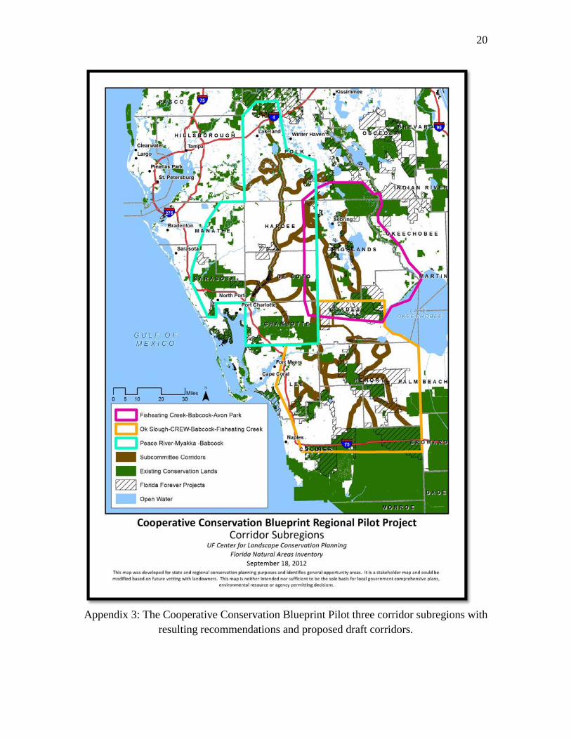
Three regional connectivity subcommittees. – Created at the Working Group’s April 2011 meeting and organized according to the geography of the three major watersheds in the pilot region, specifically the Peace River, Caloosahatchee River and Fisheating Creek/Avon Park (Appendix 3):
• Peace River Subcommittee – concentrated on the Peace River region that includes the area from the Babcock Ranch Preserve to the Green Swamp (Charlotte, DeSoto, Hardee, Polk, Sarasota and small portions of Manatee and Hillsborough counties)
• Caloosahatchee Subcommittee – focused on the Florida Panther National Wildlife Refuge to the Fisheating Creek Wildlife Management Area and the Babcock Ranch Preserve (Collier, Hendry, Lee and Glades counties)

5
• Fisheating Creek-Avon Park Subcommittee – concentrated on the Fisheating Creek Wildlife Management Area to Avon Park Air Force Range, with the vast majority of the area located in Highlands County but also including northern Glades, southeastern Polk and eastern DeSoto and Hardee counties
The subcommittee process began in June 2011 and resulted in seven stakeholder group meetings between August and December of that year. In addition to supporting the Working Group and subcommittees, pilot project staff also held meetings with numerous stakeholders, including landowners with large land holdings, and staff from local, regional and state agencies and organizations. Those efforts included early meetings with planning and natural resources staff from the counties in the pilot area as well as those from the Central Florida and Southwest Florida Regional Planning Councils and the Charlotte Harbor National Estuary Program. At the state and federal levels, meetings were held with regional and state staff of the NRCS, USFWS and the FWC. Using the Best Available Science The regional CLIP (Appendix 2) was developed specifically for the regional pilot project and identified two types of priority areas. Priority 1 represented the highest priority conservation opportunities, which included connected wildlife corridors between strategic existing conservation lands in the region, particularly with respect to the Florida panther, Florida black bear and other fragmentation-sensitive species because of the space they require. Priority 2 represented additional priority conservation areas important for protecting the region’s biodiversity and ecosystem services.
The regional CLIP built off the work of the Babcock Ranch Steering Committee, specifically the moderate connectivity scenario contained in the 2010 Babcock Ranch Regional Connectivity Study that assessed wildlife corridor connectivity for an area that is consistent with that of the regional pilot project. It also included local and regional information about conservation priorities submitted by local participants in the pilot project. Linking Priority Conservation Corridors to Private Landowner Incentives The pilot project coupled identifying conservation priorities with the incentives that will make having land in the corridors an economic benefit for landowners. The focus on incentive-based conservation was especially important because of dwindling public resources for acquisition.

6
The Working Group emphasized that incentives should be voluntary, non-regulatory and predictable. They should also be in place when introducing areas that merit conservation. The incentives examined by the group included two types: • Existing, which are generally government-based • New, which are market-based and provide an alternative source of conservation
funding
Whether considering existing conservation incentives or new ones, it is important to remember that the one-size-does-not-fit-all rule applies. The most appropriate incentives and how they are combined and structured will vary by the type of land ownership (family- versus corporate-owned, for example) and land use (one large tract under one owner or many smaller owners with small land holdings). Targeted landowner outreach is also important. RESULTS To develop recommendations for wildlife corridor priorities, the three subcommittees used the regional CLIP data as a starting point to identify opportunities and obstacles for restoring landscape connectivity. By and large, opportunities were the feasible routes that passed through as many existing public (federal, state and local) and private conservation areas as possible. That was especially important because of the number of public agencies and environmental organizations that consider the region to be of high conservation priority. County land acquisition programs were also viewed as opportunities to establish corridors through fee-simple and less-than-fee acquisition. Obstacles to regional landscape connectivity included developed areas, platted lots, proposed intensive development in local future land use plans, increases in intensive agricultural uses, and extensive existing or proposed new highway. An additional obstacle was Developments of Regional Impact (DRI). A DRI is defined in Florida planning laws as any development that, because of its character, magnitude or location, would have a substantial effect upon the health, safety or welfare of citizens of more than one county. Where possible, alternative routes were identified to avoid or go around or under (in the case of roads, for example) obstacles. Existing Incentives The Blueprint team’s work on existing incentives focused on creating a menu that identifies the programs already in place with the most potential to protect conservation

7
priority areas in the pilot region. The ultimate goal is an implementation tool that matches incentives to specific corridors and/or focal areas within them. Some of those programs and their advantages include: • County acquisition programs – Can be used to fill in gaps or remove bottlenecks
between existing public conservation lands through either fee or less-than fee (a conservation easement only) acquisition. Funding, where it is not in place, is needed for those programs. Lot swaps or transfer of development programs could also be used, for example, to address platted lots in the central Fisheating Creek-Avon Park corridor.
• Conservation banks for federally listed species and wetland mitigation banks – Can be used to preserve and restore corridors. Both are applicable to the Peace River area, for example. The Fisheating-Avon Park region also presents opportunities for conservation banking, specifically scrub banking for the sand skink and Florida scrub jay. A conservation or mitigation bank is privately or publicly owned land that is managed for specified conservation purposes (for example, as habitat for listed species and/or as restored or enhanced wetlands). The bank operator (a landowner, for example) receives income for permanently protecting the land and managing it for a specified conservation purposes. In exchange, the bank may sell credits (habitat or wetland, depending on the type of bank) to a private business or landowner, government agencies and other types of organizations that need to compensate for the environmental impacts of a project. Those impacts can be on- or off-site. The benefits to a buyer are the time and cost savings of being able to make a one-time purchase of credits from a pre-approved bank. Conservation and mitigation banks are approved and monitored by a permitting agency (the USFWS for wildlife banks, for example).
Conservation banks are a type of Payment for Ecosystem Services (PES) program where the market is established by a public regulation. The benefitting entities provide some type of payment or other incentives to compensate landowners who provide a desired environmental service. When located on private lands, wetland mitigation banks are another type of PES. The emphasis on PES programs builds on the recommendations of the Blueprint working groups charged with identifying new and innovative ideas for private landowner conservation incentives. In order for a PES program to work, the working groups advised that:
• Public and private utilities or agencies requiring an environmental service should first
look to agricultural landowners to provide those services through land management practices and restoration activities.

8
• The concept of ecosystem services solutions to public service and facilities needs ought to be grounded in local comprehensive and capital improvement plans and the strategic regional policy plans of Florida’s Regional Planning Councils.
An example is a public or private utility or agency that contracts with agricultural landowners who agree to engage in practices that result in the storage of water to prevent flooding and to improve water quality. The provision of those services becomes another component of an agricultural landowner’s business and management plan. Florida already has a successful example: the South Florida Water Management District’s (SFWMD) Northern Everglades Payment for Environmental Services Program, a dispersed water storage project involving regional water managers and agricultural landowners. Ideas for New Incentives The two principal ideas for new incentives that came out of the regional pilot project are forms of a PES program. Those proposals include a gopher tortoise conservation program and a private watershed fund that would support water quality and supply projects in select watersheds in Florida.
Gopher tortoise PES program. – A test program was designed to compensate landowners for engaging in land use practices to maintain or improve habitat for the gopher tortoise. This is consistent with the goal of the FWC’s Gopher Tortoise Management Plan, which is to restore and maintain secure, viable populations of gopher tortoises. The program is based on extensive research about PES programs and literature reviews as well as discussions with landowners, land managers, field ecologists and experts on the gopher tortoise. Of particular importance is the emphasis on understanding the southwest-south-central Florida habitat which is regionally unique. Program features include the following: • FWC’s payments to landowners will be based on a three-tier habitat system that will
be ranked during an on-site evaluation. Payment amounts are expected to be similar to hunting or cattle leases, which are also based on habitat quality.
• Landowners will have an opportunity to move up through habitat quality tiers, thus enabling them to potentially increase the payments they receive for the added lift in habitat quality. The gopher tortoise habitat management plan provided by FWC will describe the actions a landowner can take in order to move up through the tiers.

9
• Benefits to landowners include reliable annual payments and the ability to continue with well-managed agricultural activities (grazing, hunting and silviculture, for example) that are compatible with gopher tortoise habitat.
An important aspect of the pilot gopher tortoise PES program is that it is a separate system from FWC’s gopher tortoise recipient site program. Landowners who permit recipient sites will not be eligible to participate in the gopher tortoise PES program. Wildlands Conservation worked on developing and testing a pilot Gopher Tortoise Payment for Ecosystem Services Program during 2013 and 2014. They worked with six property owners to test various techniques and methodologies for evaluating gopher tortoise habitat. They worked closely with landowners and discussed various program and payment options. Input was invaluable and all of the participating landowners are enthusiastic about continuing a PES program. All of the landowners had property that contained priority gopher tortoise habitat identified in various versions of FWC’s gopher tortoise habitat model or Dr. Tom Hoctor’s habitat model. The pilot properties were located in Hardee, Desoto and Charlotte counties; these counties were part of the Cooperative Conservation Blueprint Regional Pilot area. Staff chose landowners who had at least 40 acres of priority habitat identified in one of the models and that had large amounts of gopher tortoise habitat as well as diversity of habitats. Landowners were paid $10/acre of habitat (as identified in the model). Once contracts were signed and payment was complete fieldwork began. Gopher tortoise habitat delineation techniques and habitat assessment methodologies were tested. Wildlands worked with FWC staff, NRCS staff, University of Florida, and consulted with FNAI and other gopher tortoise biologists during this time. This program provided a unique opportunity to examine gopher tortoise habitat on private lands in an area understudied for the gopher tortoise.
Watershed Fund of Florida. – This proposal provides the framework for addressing one of the biggest issues facing the state – water and, in particular, storing it in such a way to reduce nutrient loads and provide water supply. The approach could also make available additional sources of funding for the restoration or conservation of priority natural resources. The Watershed Fund of Florida would be a new nongovernmental enterprise dedicated to maintaining healthy watersheds and sustainable water resources in the state. The details of how the fund would work would be developed through a collaborative process involving leaders of organizations and rural landowners interested or involved in strategically conserving Florida’s water resources.

10
Two early fund initiatives are outlined below. The first relates to water quality credit trading and the other to bringing together resources from multiple sources to fund watershed restoration.
Water Quality Credit Trading (WQT). –Voluntary Water Quality Credit Trading
Programs can be a cost-effective way to help solve water quality problems. WQT is increasingly being used in other states to achieve water quality goals more efficiently and at substantially lower cost than other means. The approach is market-based and involves a voluntary exchange of nutrient reduction credits within a watershed. The market works because entities in a watershed face very different costs to control the same pollutants. Those with a higher pollution control cost to meet the nutrient discharge limits specified in their permits can chose to buy pollutant reduction credits from those with a lower control cost to achieve the same outcome. The credit price is determined by negotiations between the buyer and seller or through a third party broker. The exchange can occur between two point sources or between a point source and nonpoint source. • When pollutants come from a single source they are known as point sources, for
example a wastewater treatment plant or a manufacturing facility. Although point sources are easy to identify, resolving water pollution problems typically requires investing in expensive equipment and new technologies, costs that can continue to increase as the population grows.
• Nonpoint sources are not as specific as point sources and usually involve water that runs off fields or lawns. As the pollutants come from many different sources in different ways, they are harder to measure. However, the techniques and practices that farmers, for example, can use to reduce the amount of nutrients they contribute to waterways are relatively low in cost.
The seller and buyer can trade directly or they may turn to a third party to aggregate and broker the exchange of water quality credits. Providing that third party role enables buyers and sellers to readily access water quality trading markets, reduces trading transaction costs, provides some protection from liability and helps reduce the risk for buyers. In Florida, point-to-point trading has already been tested by the state in the pilot water quality credit trading program for the Lower St. Johns River. For that reason, the Watershed Fund of Florida would focus on watersheds that provide opportunities to aggregate credits from nonpoint sources for potential sale to point sources. The first step is to conduct a feasibility study. This would involve examining nonpoint practices that

11
reliably result in improved water quality and identifying potential buyers including permitted point sources interested in and in the position to purchase nutrient offsets, as defined in EPA’s trading guidelines.
Funding watershed restoration. – There is a need to bring together resources from multiple sources to fund watershed restoration. The emphasis on watersheds recognizes the importance in finding effective, cooperative solutions to water quality and quantity (including storage capacity) problems. The concept is to involve contributions from private corporations and citizens who would be able to support watershed restoration through, for example, a voluntary check-off on their water utility bills. The creation of such a watershed fund in Florida: • Responds to the Landowner Assistance Group’s advice to identify potential sources
of funding that could be used to expand the current regional NE-PES to other parts of the state. Compensating agricultural landowners, including those engaged in forestry, for performing watershed services will help solve some of the state’s pressing water problems.
• Is timely as it could provide a less costly way of complying with state and federal rules for water pollution, specifically numeric nutrient criteria (NNC) standards. Those standards limit the amount of nutrients that come from various sources, including fertilizers, sewage effluent, stormwater runoff and animal waste. Too many nutrients cause algae blooms that are harmful to freshwater and marine life as well as people.
• Recognizes the importance of taking a holistic watershed-based approach to water management, an emphasis of the Florida Department of Environmental Protection (DEP) and the goal of the U.S. Environmental Protection Agency’s (EPA) new Healthy Watersheds Initiative. Watershed planning follows the water: all water within a watershed ultimately drains into a common body of water. That means everything upstream ends up downstream and what happens on the land along the water’s route is important. In order to best protect them, DEP has grouped Florida’s 52 watersheds or basins into 29 groups.
The proposed Watershed Fund could, as described in its mission, create a new water legacy for Florida and reclaim the state’s watersheds that have experienced cumulative damage over many years. Essential to that legacy will be partnerships with rural landowners in solving the state’s water problems. Focal Areas

12
The regional pilot project began the process of identifying strategic focal areas (Appendix 4) during the summer of 2014. Identification of these focal areas was necessary in order to focus analysis and conservation efforts. Identified areas were prioritized in the stakeholder groups and met at least one of the following criteria:
• High priority areas for conservation that are threatened by development in the near future
• High priority areas for conservation that are bottlenecks within identified wildlife/ecological corridors
• High priority areas for conservation that have very high feasibility for protection in the near future such as qualification for existing conservation programs, landowner interest, etc.
Many areas within the stakeholder corridors met these criteria. Focal areas were developed into levels, or ‘tiers’. The tiers were developed via an analysis of the ecological conservation significance of the area and by how well they fit the criteria above. Factors included whether focal areas overlapped with priority data layers such as the Florida Ecological Greenways Network, CLIP 3.0, or the Regional CLIP. DISCUSSION The Cooperative Conservation Blueprint Pilot Project has produced a science-based synthesis of state and regional conservation priorities, stakeholder identification of wildlife corridor conservation priorities in southwest Florida (Appendix 3), and discussed (and agreed upon) incentives-based conservation tools and strategies working with landowners, agencies, and NGOs. The next steps of the Blueprint process are to move forward with identification of specific implementation opportunities within the Pilot Project region including implementation of focal areas within stakeholder corridors, additional strategic landowner vetting, and solidifying the status of Blueprint data and recommendations in the policies and programs of relevant regional, state, and federal agencies. The results of the regional pilot project highlight the importance of: • Creating the wildlife corridors that functionally connect the larger conservation areas
within and adjacent to the region, using the southwest and south central Florida Blueprint to help focus on the most important lands that need conservation. That connectivity is critical for many focal species in the region, including the Florida panther and black bear that are sensitive to habitat fragmentation and intensive human activities.

13
• Securing multiagency recognition of the location and importance of the corridors and additional conservation priority areas (wetlands restoration opportunities, for example). That should include facilitating the desired connectivity through greater agency coordination and recognition of those connections by assigning them higher ranking priorities in acquisition and other conservation incentive programs.
• Having meaningful private landowner conservation incentives in place before specifically delineating the corridors to protect. The incentives should be developed in consultation with landowners and designed to demonstrate that owning priority conservation areas is a positive economic choice. A menu of incentives is also important, because no single incentive will accomplish the conservation goals.
• Combining a sound scientific understanding and identification of the resources with an open stakeholder dialogue. That involvement should start at the beginning of and continue throughout any conservation planning process. It also should include an emphasis on those who own the land, a cornerstone of the Blueprint process which recognizes that success will depend to a great degree on landowner participation.
CONCLUSIONS If Florida is to achieve the conservation required to ensure robust, functioning green infrastructure systems serving all parts of the state and providing the environmental services essential to wildlife, watershed and human health, future actions must build on and continue Blueprint core principles: science-, incentive- and multipartner-based collaborative decision-making. Moving forward, the Blueprint recommends: • Developing the detailed data needed to accurately identify specific conservation
priorities throughout the state. • Coupling the identification of conservation corridors with putting in place a menu of
voluntary incentives that will make owning and conserving land in those corridors an economic asset.
• Aligning the policies and investments of federal, state and regional agencies and conservation organizations with consensus-based strategic conservation priorities, including ecological connectivity.
• Partnering with the USFWS’ Peninsular Florida Landscape Conservation Cooperative to implement the Blueprint vision.
Develop the detailed data needed to accurately identify specific conservation priorities throughout the state.
14
The Blueprint Lesson.– Grounding conservation plans and decisions in the best available science is important to reaching agreements about what needs to be conserved and how. For the Blueprint, the science includes the statewide CLIP data and the more detailed data developed through the regional pilot project. That science underscored the importance of ecological connectivity to maintaining healthy ecosystems.
Recommendations. –
• Within the regional pilot project area, continue to refine the more detailed data needed to enhance the identification and protection of the corridors and other conservation priorities that will help maintain ecological functions for focal species and other environmental services. This will require more tightly integrating and comparing CLIP and other regional and local data and conservation priorities.
• Extend the regional CLIP and Blueprint pilot approach to other parts of Florida. This would involve starting with CLIP data and bringing in additional regional and local knowledge to identify and integrate science and stakeholder conservation priorities. Such data will enhance and facilitate the conservation work of federal, state and regional agencies and other partners.
• Use CLIP to identify strategic areas that need immediate attention. Those areas may include high priority resources that are or may soon be threatened by more intense development, bottlenecks that interfere with the needed connectivity or priority areas where there is a timely opportunity for protection.
Couple the identification of conservation corridors with putting in place a menu of voluntary incentives that will make owning and conserving land in those corridors an economic asset.
The Blueprint Lesson. – Coupling the identification of conservation corridors with voluntary incentives is important to motivate a landowner to participate in achieving conservation goals. This is particularly important in Florida where a large part of the state’s priority natural systems is under the ownership of people who earn their income from the land – the state’s farmers, ranchers and foresters. Their participation, therefore, is essential to the Blueprint’s success. In addition, the Blueprint’s focus on incentives augments limited public funds by providing new sources of revenue that are market- and/or or public-private partnership based. It also enables rural lands to remain in private ownership and management, thereby providing an economic return along with the desired environmental outcomes.
Recommendations. –Blueprint recommendations center on the expansion of existing incentives and creation of new ones. The recommendations underscore the fact that in

15
order to provide the requisite economic value for landowners, incentives should be designed to be used separately or in combination and tailored to fit individual landowner needs, since different types of land ownership, agricultural uses and geographic areas will require different approaches. Recommendations for expanding existing incentives:
• Broaden the use of transfer of development rights programs that pay landowners for their development rights and transfer them to designated areas with the infrastructure for more intense development. That approach has two benefits: protection of the intact natural systems and corridors required for ecosystem health and more efficient use of land that is developed.
• Change mitigation banking rules to encourage projects that promote natural system connectivity and other strategic conservation benefits. That recommendation builds on the successful creation of habitat conservation and wetland mitigation banks by a number of state and federal agencies, including DEP, the Florida Department of Transportation (FDOT), the state’s water management districts and the U.S. Army Corps of Engineers.
Recommendations for new incentives based on Payments for Environmental Services:
• Implement the gopher tortoise PES program to compensate landowners who provide and restore healthy gopher tortoise habitat within the Blueprint regional pilot project area. The program should include initiating the test period with a selected group of landowners, using the results to refine the PES protocol and moving forward with the ongoing program.
• Initiate the nonpoint water quality credit trading program feasibility study called for in the Watershed Fund of Florida proposal. The two principal avenues of research are to identify practices that nonpoint operations can use to reliably improve water quality, and the regulated entities that are interested in and have the ability to purchase water quality credits. The study will also be used to identify specific opportunities to set up pilot trades in one or more watersheds. It will also identify good candidates for credit generator and credit buyer case studies and how a credit aggregation and brokerage service or trading cooperative could work.
Align the policies and investments of federal, state, regional and local agencies and conservation organizations with consensus-based strategic conservation priorities including ecological connectivity.

16
The Blueprint Lesson. – Achieving a healthy, conserved natural and rural Florida for future generations will require public agencies at all levels and nonprofit organizations with an interest in resource conservation to pull in the same direction. That means they need to recognize and embrace a consensus set of strategic conservation priorities including ecological connectivity when making policy and investment decisions.
Recommendations. – Continue to work with public agencies at all levels and other conservation partners to: • Use one consistent data set as the foundation for identifying the priority areas that are
essential to ecosystem viability. That should begin with CLIP, bringing in other data as needed. A first step is to formally recognize the strategic corridors and other conservation priorities identified in the Blueprint’s regional pilot project.
• Incorporate shared priorities and the importance of ecological connectivity in planning, policy and funding decisions. At a minimum, this should include projects located in, adjacent to or near Blueprint designated corridors and Regional CLIP priorities. For example, the regional pilot project team is working with the NRCS to consider giving bonus points for Wetland Reserve Program projects located in areas important to connectivity. Two additional examples are USFWS’ Florida wildlife refuge proposals (Everglades Headwaters National Wildlife Refuge and the Fisheating Creek and Florida Panther Refuge Study Areas) and the South Florida Water Management District’s Northern Everglades Payment for Environmental Services Program. The Florida Office of Greenways and Trails provides another opportunity through its updated greenways and trails plan and its work to bring greater attention to the importance of critical ecological linkages.
• Incentivize directing future development away from conservation priorities and corridors and minimize environmental impacts on them. It is also important for agencies to regain ownership of areas that are critical to maintaining functional and connected natural system corridors.
Partner with the USFWS’ Peninsular Florida Landscape Conservation Cooperative to implement the Blueprint vision.
The Blueprint Lesson. – Conserving Florida’s rural lands is too large a task for a single agency or organization to accomplish alone. Partnering the Blueprint with the USFWS’s Peninsular Florida Landscape Conservation Cooperative (PFLCC) enables the FWC to stretch Blueprint resources, maximize its exposure and heighten its opportunities for full implementation. The FWC has been a strong champion and shepherd of the Blueprint, but it now needs company.
17
The Recommendations. – As the USFWS carries on the work of the Blueprint, it should build on and retain the ingredients that were fundamental to Blueprint success in achieving its goal to develop a widely supported, understood and used vision of the natural resource systems that are important to maintaining the state’s human, wildlife and economic health. This includes continuing to invest in developing the best available science to enable informed decision making (something that the PFLCC is already doing with the development of CLIP 3.0). It also means working with landowners to fully develop and put in place a menu of incentives that can be used separately or in combination to make owning priority natural systems and rural lands an economic asset.
Also important is educating and involving the broader public whose support is needed to develop and implement the policies and incentives that will result in achieving conservation goals. This needs to include making the link between Florida’s green infrastructure and the many essential public services they provide. The more champions there are, the greater the chance of success. A good outreach and education example is the Florida Wildlife Corridor’s <www.floridawildlifecorridor.org> 1,000- mile, 100 day expedition in early 2012. The purpose was to increase public awareness and generate support for the Florida Wildlife Corridor project that is highlighting opportunities and efforts to protect and restore a functional ecological corridor from the Everglades National Park to the Okefenokee National Wildlife Refuge in Georgia.
In summary, moving the Blueprint forward and providing a firm foundation for achieving Florida’s ambitious yet essential conservation goals will require increasing public awareness of the opportunities for and numerous benefits of protecting the state’s green infrastructure and developing a consensus set of strategic priorities that multiple organizations and agencies can use to enhance their coordination and collective actions to achieve conservation goals. It will also require continuing the emphasis on making connections:
• Within and between the mosaic of farms, ranches, groves and forests, natural lands and water resources that comprise Florida’s green infrastructure and that are essential to assuring that it stays ecologically healthy and functioning for future generations.
• Between those who own and manage much of the land where the state’s critical green infrastructure is located and the incentives that will make conserving those areas a positive economic choice.
• Among agencies at all levels and other organizations to put in place a set of coordinated policies and strategies based on shared data and prioritize the importance of natural system connectivity (creating, retaining and restoring it where needed).
• Between maintaining healthy, connected green infrastructure systems and the current and long-term well-being of the state’s watersheds, wildlife, people and economy.

18
APPENDICES
Appendix 1: The Cooperative Conservation Blueprint Pilot Area. The Blueprint pilot area encompasses 13 counties in south central and southwest Florida – a region that includes all or part of Polk, Osceola, Orange, Okeechobee, Hardee, DeSoto, Highlands, Glades,
Hendry, Collier, Lee, Charlotte and Sarasota counties.

19
Appendix 2: In addition to the compilation of regional connectivity and statewide CLIP data, several local studies have been conducted to identify conservation priorities in the
Blueprint Pilot study area. These local conservation priorities are shown collectively over the Regional CLIP Priorities.
20
Appendix 3: The Cooperative Conservation Blueprint Pilot three corridor subregions with
resulting recommendations and proposed draft corridors.

21
Appendix 4: The Cooperative Conservation Blueprint Pilot region proposed draft corridors with first Tier Focal areas.