Embed Size (px)
Citation preview

Monitoring of tropical forests using EO data:
The TREES project of the JRC and
Perspective of the REDD+ item of the UNFCCC
Frédéric AchardInstitute for Environment and Sustainability
Joint Research Centre of the European Commission
Monitoring Forest Cover at Global Scale
The Joint Research Centre (JRC) approach &
The FAO Global Forest Resource Assessment 2010 Remote Sensing Survey
JRC TREES-3 team (Tropics): Frédéric Achard, René Beuchle, Catherine Bodart, Andreas Brink, Silvia Carboni, Hugh D. Eva, Desirée Johansson, Ouns Kissiyar, Andrea Lupi, Philippe Mayaux, Rastislav Raši,
Dario Simonetti, Hans-Jürgen Stibig, Michael Vollmar, Alan Belward with support of UCL team: Pierre Defourny, Céline Ernst, Astrid Verheggen, Carlos de Wasseige
JRC FOREST team (Europe): Jesús San-Miguel-Ayanz, Lucia Seebach, Peter Strobl, Pieter Kempeneers, Fernando Sedano, Peter Vogt
FAO FRA 2010 RSS Staff: Adam Gerrand, Eric Lindquist, Mette Løyche-Wilkie

Objectives of the JRC TREES project
To reduce uncertainties in global estimates of forest cover change and related carbon emissions with focus on the Tropics and boreal Eurasia
- land cover change dynamics
- where forests are changing & by how much they are changing
- what are the resulting changes in carbon emissions
To provide information to EC services to support them in their definition of policies in the framework of multilateral environmental agreements
- climate change negotiations (e.g. REDD issue)
- potential deforestation drivers (e.g. bio-fuels)
- FLEGT: support to EU-funded projects
To contribute to capacity building in developing countries
- technical support on concepts /methods of forest monitoring (REDD / FLEGT)

JRC geographical and temporal focus
1990 2000 2005 2010

Systematic grid over the Tropics
Analysis of a systematic sample of sites with 30 m resolution satellite data

Analysis of a systematic sample of sites
20 km × 20 km size with Landsat-TM type imagery

The methodology is based on the analysis of a systematic sample of sitesfor which Landsat-type satellite data are collected
1. Data selection (for years 1990, 2000 and 2005)
2. Pre-processing
3. Automatic Segmentation
4. Semi-automatic labelling of segments
5. Regional validation
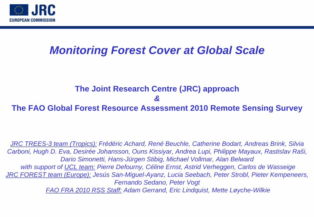
Methodology
Change Map 1990-20001990
2000
No changeLCC From Forest
LCC To
Forest
Methodology: Example

Regional validation workshops
Nairobi (28 Sept.- 2 Oct 2009)East and Southern Africa
12 Experts from 10 countries4 support staff including 3 JRC
Kinshasa (28 Sept.- 9 Oct 2009)
Central AfricaJointly organized by FAO, UCL & JRC
15 Experts from 7 countries 6 support staff including 2 JRC
Dakar (08-13 March 2010)West Africa
15 Experts from 14 countries3 JRC support staff

Year 2010 ?
Future developments: Year 2010
Mid 1970s

Future developments: radar + Year 2010
Landsat 1990
Landsat 2000
ALOS 2007
ALOS PALSAR
Mosaic 50 m res.
Year 2007

Future developments: Year 2010

TREES Perspectives & Challenges
• To produce regional trends in forest extent for all Tropics for period 1990 – 2005
• To acquire and analyse satellite data (with finer spatial resolution) from year 2010
• To contribute to REDD mechanism (through estimates of C emissions at tropical scale)

Contribution of emissions from deforestation and forest degradation
CO2 emissions from deforestation and forest degradation: ~ 1.2 Pg C yr–1
(12% [6–17%] of total anthropogenic CO2 emissions)Peat land emissions: ~ 0.30 Pg C yr–1
(Deforestation + peatland emissions = 15% [8–20%] of total CO2 emissions)Source: van der Werf et al, 2009 Nature 2:737-738


Copenhagen Accord (Decision 2/CP.15)
The Heads of State, Heads of Government, Ministers, and other heads of the following delegations present at the United Nations Climate Change Conference 2009 in Copenhagen: [List of Parties]
…
6. We recognize the crucial role of reducing emission from deforestation and forest degradation and the need to enhance removals of greenhouse gas emission by forests and agree on the need to provide positive incentives to such actions through the immediate establishment of a mechanism including REDD-plus, to enable the mobilization of financial resources from developed countries.

Copenhagen Accord
8. Scaled up, new and additional, predictable and adequate funding as well as improved access shall be provided to developing countries, in accordance with the relevant provisions of the Convention, to enable and support enhanced action on mitigation, including substantial finance to reduce emissions from deforestation and forest degradation (REDD-plus), adaptation, technology development and transfer and capacity-building, for enhanced implementation of the Convention. The collective commitment by developed countries is to provide new and additional resources, including forestry and investments through international institutions, approaching USD 30 billion for the period 2010 - 2012 with balanced allocation between adaptation and mitigation. … In the context of meaningful mitigation actions and transparency on implementation, developed countries commit to a goal of mobilizing jointly USD 100 billion dollars a year by 2020 to address the needs of developing countries. .. New multilateral funding for adaptation will be delivered through effective and efficient fund arrangements, with a governance structure providing for equal representation of developed and developing countries. A significant portion of such funding should flow through the Copenhagen Green Climate Fund.

Decision 4/CP.15 on “REDD-plus”

Decision 4/CP.15 on “REDD-plus”

COP-15 Decision on REDD+

COP-15 Decision on REDD+

Impact of KP’s weaknesses (AAU surplus & LULUCF accounting rules) on developed countries' reduction pledges in 2020
Source: EC Communication SEC(2010) 261 “International climate policy post-Copenhagen: Acting now to reinvigorate global action on climate change”

Task Force on National Greenhouse Gas Inventories
IPCC Methodologies for ForestsNalinNalin SRIVASTAVASRIVASTAVA
Task Force on National Greenhouse Gas InventoriesTask Force on National Greenhouse Gas Inventories
IPCC Expert Meeting on National Forest GHG Inventories IPCC Expert Meeting on National Forest GHG Inventories -- a Stock Taking a Stock Taking Yokohama, JapanYokohama, Japan2323--25 February, 201025 February, 2010

IPCC Guidelines for National Greenhouse Gas Inventories
• Revised 1996 Guidelines -Land-Use Change and Forestry (LUCF)
• 2000 Good Practice Guidance and Uncertainty Management (GPG2000)
• 2003 Good Practice Guidance for Land Use, Land-Use Change and Forestry (GPG- LULUCF)
• 2006 IPCC Guidelines for National Greenhouse Gas Inventories

Evolution of IPCC Guidance on agriculture and land-use

Six Land Use Categories
• Reported Under Forests:– Degradation & Forest Management
• Forest lands remaining Forest Lands– Afforestation & Reforestation
• (Cropland/Grassland/Settlements etc.) converted to Forest Lands
• Reported under non-forest lands:– De-forestation
• Forest Lands converted to (Cropland/Grassland/Settlements etc.)
• What is forest degradation?– TFI Special Report – Alternate definitions of degradation
• criteria such as long term reduction of canopy cover, supply of benefits, C stocks
• decided that no definition can be effectively operationalised
Other land
Forest land
Settlements Wetland
Cropland
Grassland

5 (+ 1) Carbon pools
Increase - Growth
Discrete Events – Fires etc
Transfers between Pools
Continuous Processes – e.g. decay
Above-Ground Biomass
Below-Ground Biomass
Dead Wood
Harvested Wood
Products
Litter
Soil Organic Matter
Optional assumptions & approaches for reporting

General methods for the estimation of emissions and removals of CO2 and non-CO2 for the LULUCF sector in the GPG 2003

Tiers for emission factors: Change in C stocks
Approach for activity data: Area change
1. Simple first order Approach:IPCC default values (large uncertainties)
1. Non-spatial country statistics (e.g. FAO) — generally gives net change in forest area
2. A more accurate Approach:Country specific data for key factors
(relatively smaller uncertainties)
2. Based on maps, surveys, and other national statistical data
3. Higher order methods:Detailed modeling and/or inventory of key C stocks, repeated measurements
(lower uncertainties)
3. Spatially specific data from interpretation of remote sensing data
A summary of which approach can be used for the activity data and which Tier for the emission factors for estimating emissions & removals of CO2.
Approaches for activity data and Tiers for emission factors

Remote Sensing systems in 2006 IPCC Guidelines
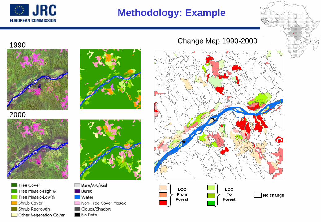
GOFC-GOLD Sourcebook v 3 presented in Copenhagen
http://www.gofc-gold.uni-jena.de/reddhttp://www.grs.wur.nl/UK/Workshops/GOFC_GOLD/
Remote sensing support for carbon estimation
Direct biomass mapping remains a challenge
Existing capabilities:Satellite observation may help to map some specific forest types(i.e. mangroves, plantations etc.)
Deforestation/degradation mapping to guide field surveys – focus on area of most change
Targeted remote surveys to support carbon accounting:
• Very high resolution satellite data of air-photo quality to assist field surveys
• Some sensitivity of data LIDAR and RADAR systems• Integration of in-situ and satellite data for large scale biomass
mapping• Direct estimation of emissions from fire radiative power

Conclusions on REDD+
The future REDD+ mechanism will require the use of a combination of remote sensing and ground-based forest carbon inventory approaches for estimating anthropogenic GHG emissions by sources and removals by sinks, forest carbon stocks and forest area changesThe current IPCCC guidelines provide some limited guidance on the use of different data sources including remote sensing, ground based inventories and their combinationFurther scientific and technical work is needed to collect and access, analyse and interpret data, in order to develop more accurate estimates at national level.