Embed Size (px)
Citation preview
PSZ 19:16 (Pind. 1/13)
MONITORING LAND SUBSIDENCE OF AIRPORT USING INSAR TIME-SERIES
TECHNIQUES WITH ATMOSPHERIC AND ORBITAL ERROR CORRECTIONS
ANIS AFIRAH BINTI MOHAMAD RADHI
UNIVERSITI TEKNOLOGI MALAYSIA

i
MONITORING LAND SUBSIDENCE OF AIRPORT USING INSAR TIME-
SERIES TECHNIQUES WITH ATMOSPHERIC AND ORBITAL ERROR
CORRECTIONS
ANIS AFIRAH BINTI MOHAMAD RADHI
A thesis submitted in fulfillment of the
requirements for the award of the degree of
Master of Science (Remote Sensing)
Faculty of Geoinformation and Real Estate
Universiti Teknologi Malaysia
FEBRUARY 2017

iii
A special mention to my beloved parent….
Hj Mohamad Radhi bin Hj Othman,
Hjh Nooraini binti Hj Yaacob ,
For giving me a lot of encouragement and strength to success…. love u both lillahi..
To my siblings,
Baish, Na, Iejad, Kak Min, and Qimi
Thanks for a lot of help in moral and financial support and understanding my
situation
To friends,
“Geng aras 5”, “Geng usrah”, “Geng Master”
Thanks for all your support, advice and willing to be companions in good and bad
times…
To all,
I hope we will meet again later in future and Jannah Insya Allah
iv
ACKNOWLEDGMENT
With The Name of Almighty Allah, Most Merciful Generous
Thank god, for His mercy and kindness, this master degree finally completed.
Infinite appreciation and gratitude to supervisor Dr Md Latifur Rahman Sarker for
sharing ideas, provide encouragement and guidance to complete this master thesis. I
also would like to thank the Ministry of Higher Education (MOHE) for providing
grant (R.J130000.7827.4F689) entitled “Determination of Floodplain Change and its
Impact on Flood Modelling Using Multi-Temporal DEM and Land Use/Land Cover
from InSAR/SAR Technique” for financial support. Special thanks also goes to
Japan Aerospace Exploration Agency (JAXA) for providing the ALOS data, under
the project No. P1387002.
Sincere appreciation also goes out to all the lecturers and staff of the
Department of Geomatics for their cooperation, guidance and assistance provided
during my master study at UTM. Thank you also specially goes to lab mates and
floor mates which together in this struggle and also the unwavering support and
invaluable experience that we have over 3 years of our journey.
Lastly I would like to thank everyone who helped directly or indirectly in
completing this project. Without you guys it means nothing to me. And my
guideline, the very inspiration words (2:11, 12,164; 4:78-79; 23:17-22). Thank you
so much.

v
ABSTRACT
Land subsidence is one of the common geological hazards worldwide and
mostly caused by human activities including the construction of massive
infrastructures. Large infrastructure such as airport is susceptible to land subsidence
due to several factors. Therefore, monitoring of the land subsidence at airport is
crucial in order to prevent undesirable loss of property and life. Remote sensing
technique, especially Interferometric Synthetic Aperture Radar (InSAR) has been
successfully applied to measure the surface deformation over the past few decades
although atmospheric artefact and orbital errors are still a concerning issue in this
measurement technique. Multi-temporal InSAR, an extension of InSAR technique,
uses large sets of SAR scenes to investigate the temporal evolution of surface
deformation and mitigate errors found in a single interferogram. This study
investigates the long-term land subsidence of the Kuala Lumpur International Airport
(KLIA), Malaysia and Singapore Changi Airport (SCA), Singapore by using two
multi-temporal InSAR techniques like Small Baseline Subset (SBAS) and Multiscale
InSAR Time Series (MInTS). General InSAR processing was conducted to generate
interferogram using ALOS PALSAR data from 2007 until 2011. Atmospheric and
orbital corrections were carried out for all interferograms using weather model,
namely European Centre for Medium Range Weather Forecasting (ECMWF) and
Network De-Ramping technique respectively before estimating the time series land
subsidence. The results show variation of subsidence with respect to corrections
(atmospheric and orbital) as well as difference between multi-temporal InSAR
techniques (SBAS and MInTS) used. After applying both corrections, a subsidence
ranging from 2 to 17 mm/yr was found at all the selected areas at the KLIA.
Meanwhile, for SCA, a subsidence of about less than 10 mm/yr was found.
Furthermore, a comparison between two techniques (SBAS and MInTS) show a
difference rate of subsidence of about less than 1 mm/yr for both study area. SBAS
technique shows more linear result as compared to the MInTS technique which
shows slightly scattering pattern but both techniques show a similar trend of surface
deformation in both study sites. No drastic deformation was observed in these two
study sites and slight deformation was detected which about less than 20mm/yr for
both study areas probably occurred due to several reasons including conversion of
the land use from agricultural land, land reclamation process and also poor
construction. This study proved that InSAR time series surface deformation
measurement techniques are useful as well as capable to monitor deformation of
large infrastructure such as airport and as an alternative to costly conventional
ground measurement for infrastructure monitoring.

vi
ABSTRAK
Pemendapan tanah merupakan salah satu bencana geologi yang sering terjadi di seluruh dunia dan kebanyakannya disebabkan oleh aktiviti manusia termasuk pembinaan infrastruktur secara besar-besaran. Infrastruktur yang besar seperti lapangan terbang juga terdedah kepada masalah pemendapan tanah disebabkan oleh beberapa faktor. Oleh itu, pemantauan tanah mendap di lapangan terbang adalah penting untuk mengelakkan kerugian yang tidak diingini sama ada harta mahupun nyawa. Teknik penderiaan jauh, terutamanya radar apertur sintetik interferometer (InSAR) telah berjaya digunakan untuk mengukur perubahan bentuk muka bumi sejak beberapa dekad yang lalu walaupun artifak atmosfera dan ralat pada orbit masih menjadi isu dalam teknik pengukuran ini. Teknik multi temporal InSAR, iaitu lanjutan daripada InSAR, menggunakan set data pemandangan SAR yang besar untuk mengkaji evolusi temporal perubahan bentuk muka bumi dan mengurangkan ralat yang ditemui dalam satu interferogram tunggal. Kajian ini mengkaji pemendapan tanah untuk jangka masa yang panjang terhadap Lapangan Terbang Antarabangsa Kuala Lumpur (KLIA), Malaysia dan Lapangan Terbang Changi (SCA), Singapura dengan menggunakan dua teknik multi temporal InSAR iaitu garis asas bersubset kecil (SBAS) dan pengukuran siri masa InSAR pelbagai skala (MInTS). Proses asas InSAR dilakukan untuk menghasilkan interferogram dengan menggunakan data ALOS PALSAR dari 2007 hingga 2011. Pembetulan atmosfera dan orbit telah dijalankan ke atas semua interferogram menggunakan model cuaca iaitu julat pengantar ramalan cuaca pusat Eropah (ECMWF) dan teknik Peningkatan Secara Rangkaian sebelum membuat anggaran siri masa pemendapan tanah. Keputusan menunjukkan terdapat variasi pemendapan tanah selepas pembetulan (atmosfera dan orbit) serta perbezaan antara teknik-teknik InSAR (SBAS dan MinTS) yang digunakan. Selepas kedua-dua pembetulan dilakukan, pemendapan tanah antara 2 hingga 17 mm/tahun ditemui di semua kawasan yang terpilih di KLIA. Sementara itu, bagi SCA, pemendapan tanah kurang daripada 10 mm/tahun ditemui. Tambahan pula, perbandingan di antara kedua-dua teknik (SBAS dan MInTS) menunjukkan kadar perbezaan pemendapan tanah sebanyak kurang daripada 1 mm/tahun bagi kedua-dua kawasan kajian. Teknik SBAS menunjukkan hasil yang lebih linear berbanding dengan teknik MInTS yang menunjukkan sedikit corak serakan tetapi kedua-dua teknik menunjukkan arah aliran deformasi yang sama di kedua-dua kawasan kajian. Tiada deformasi permukaan yang ketara diperhatikan di kedua-dua tapak kajian dan sedikit deformasi permukaan dikesan iaitu kurang dari 20mm/tahun di kedua-dua kawasan kajian mungkin berlaku disebabkan oleh beberapa sebab termasuk penukaran guna tanah daripada tanah pertanian, proses penambakan tanah dan juga pembinaan yang tidak kukuh. Kajian ini membuktikan bahawa pengukuran siri masa deformasi permukaan mengunakan InSAR sangat berguna serta mampu untuk memantau deformasi di infrastruktur yang besar seperti lapangan terbang dan boleh digunakan sebagai alternatif kepada pengukuran konvensional di permukaan tanah yang mahal dalam pemantauan infrastruktur.

vii
TABLE OF CONTENTS
CHAPTER TILTLE PAGE
AUTHOR’S DECLARATION ii
DEDICATION iii
ACKNOWLEDGEMENT iv
ABSTRACT v
ABSTRAK vi
TABLE OF CONTENTS vii
LIST OF TABLES xiii
LIST OF FIGURES xiv
LIST OF SYMBOLS xix
LIST OF ABBREVIATIONS xxii
LIST OF APPENDICES xxv
1 INTRODUCTION 1
1.1 Background of Study 1
1.2 Problem statements 6
1.3 Research Objectives 9
1.4 Scope of the Study 11
1.5 Study Area 13
1.6 Significance of the Study 15
1.7 Thesis Outline 17
viii
2 LITERATURE REVIEW 18
2.1 Radar 18
2.2 Synthetic Aperture Radar (SAR) 19
2.2.1 Resolution 20
2.2.2 SAR Geometrical Effects 21
2.2.3 Satellite Orbit Configuration 22
2.2.4 SAR Image 23
2.2.4.1 SAR Amplitude Image 24
2.2.4.2 SAR Phase Image 24
2.2.4.3 Speckle 25
2.3 Interferometry Synthetic Aperture Radar (InSAR) 26
2.3.1 Interferometry Equations 27
2.3.2 Altitude Ambiguity 30
2.3.3 Orbit Ramp 30
2.3.4 Atmospheric Phase Screen 31
2.3.5 Deformation Phase 32
2.4 InSAR Processing 32
2.4.1 Interferogram Generation 33
2.4.2 Interferometric Correlation (Coherence) 35
2.4.3 Filtering 37
2.4.4 Phase Unwrapping 38
2.5 Differential Interferometry Synthetic Aperture Radar
(DInSAR) 39
2.6 Multi-Temporal Technique 41
2.6.1 Small Baseline Subset (SBAS) 42
2.6.2 Multiscale InSAR Time Series (MInTS) 45
2.7 Natural Characteristic of the Interferogram 46
2.7.1 Atmospheric Delay: Tropospheric Delay 47
2.7.2 Orbital Error 49
2.8 Land Subsidence 52
2.9 Land Subsidence Monitoring 54
2.10 Land Subsidence Monitoring At Airport 57
2.11 Summary 59

ix
3 METHODOLOGY 60
3.1 Datasets 60
3.1.1 ALOS PALSAR Sensor Data 60
3.1.2 Data Selection And Data Availability 62
3.1.2.1 Data Availability for Kuala
Lumpur International Airport 63
3.1.2.2 Data Availability at Singapore
Changi Airport 64
3.1.3 Software Description 65
3.2 Processing Steps 66
3.3 Generation of Differential Interferogram 67
3.3.1 Focusing 67
3.3.2 Coregistration 68
3.3.3 Interferogram Generation 70
3.3.4 Removing Topography 72
3.3.5 Coherence Generation 74
3.3.6 Filtering 75
3.3.7 Phase Unwrapping 77
3.3.8 Geocoding 79
3.4 Time-Series Analysis 81
3.4.1 Stack preparation and Stack Preprocessing 81
3.4.2 Atmospheric Correction 82
3.4.3 Orbital Correction With Network
De-Ramping 84
3.4.4 Small Baseline Subset (SBAS) 86
3.4.5 Multiscale InSAR Time-Series 88
3.4.5.1 Interferogram Wavelet
Transformation 88
3.4.5.2 Parametrization of The Wavelet
Coefficients 89
3.4.5.3 Inverse Wavelet Transformation 91
3.5 Land Subsidence Measurement 92
3.6 Summary 92
x
4 RESULT AND ANALYSIS 93
4.1 DInSAR Results 93
4.1.1 Raw data 93
4.1.2 Data focusing 95
4.1.3 Resample Image and Interferogram
building 98
4.1.4 Removing topography 100
4.1.5 Coherence computing 102
4.1.6 Filtering 105
4.1.7 Phase unwrapped and Geocode 107
4.2 Atmospheric Correction 117
4.2.1 Atmospheric Model: ECMWF 117
4.2.2 Atmospheric Correction Results
for KLIA 121
4.2.3 Atmospheric Correction Results
for SCA 123
4.3 Orbital Ramp Correction 125
4.3.1 Orbital Ramp Correction for KLIA 125
4.3.2 Orbital Ramp Correction for SCA 128
4.4 Land Deformation Measurement using SBAS 130
4.4.1 Land Deformation Measurement
using SBAS at KLIA 130
4.4.1.1 Without
Atmospheric and
Orbital correction 131
4.4.1.2 With atmospheric
and orbital
correction 133
4.4.1.3 Variation of Land
Deformation
Estimation before
and after the
atmospheric and
orbital correction 135
xi
4.4.2 Land Deformation Measurement
using SBAS at SCA 141
4.4.2.1 Without atmospheric
and orbital
correction 141
4.4.2.2 With atmospheric
and orbital
correction 143
4.4.2.3 Variation of Land
Deformation
Estimation before
and after the
atmospheric and
orbital correction 146
4.5 Land Deformation Measurement using MInTS 150
4.5.1 Estimation of Land Deformation
using MInTS at KLIA 150
4.5.2 Estimation of Land Deformation
using MInTS at SCA 152
4.5.3 Comparison of deformation
Estimation between SBAS
and MInTS Techniques 154
4.5.3.1 Comparison for KLIA 154
4.5.3.2 Comparison for SCA 160
4.6 Summary 164
5 DISCUSSION 165
6 CONCLUSION AND RECOMMENDATION 172
6.1 Conclusion 172
6.2 Recommendation 174

xii
REFERENCES 175
Appendices A – H 203-211
xiii
LIST OF TABLES
TABLE NO TILTLE PAGE
3.1 Data Configurations with Sensor Properties
(Source: ASF, 2016) 61
3.2 Specification of ALOS PALSAR data used for KLIA 63
3.3 Specification of ALOS PALSAR data used for SCA 64

xiv
LIST OF FIGURES
FIGURE NO TILTLE PAGE
1.1 Map of Langat Basin (Source: Bringemeier, 2001) 14
1.2 Singapore Changi Airport (red circle) which
built on reclaimed land (Source: Utexas, 2016) 15
2.1 Azimuth resolutions in top view (Source: Unavco, 2008) 20
2.2 Range resolution from end view (Source: Unavco, 2008) 21
2.3 Radar foreshortening, layover, and shadow effects
(Source: Hensley et al., 2007) 22
2.4 Concept of ascending and descending orbits
(Source: Parviz, 2012) 23
2.5 Emitted and backscattered sinusoidal signal
(Source: Goudarzi, 2010) 25
2.6 Example of speckle noise (Source: Parbleu, 2007) 26
2.7 InSAR geometry (Source: Luzi, 2010) 29
2.8 Basic DInSAR processing steps (Source: Hu et al., 2014) 33
2.9 Steps for MInTS (Source: Lin et al., 2010) 46
3.1 AUIG2 provided by JAXA 62
3.2 Overall methodology 66
3.3 SLC image which contain amplitude (left) and phase
(right) 68
3.4 Example of coregistration (Source: Zou et al., 2009) 70

xv
3.5 Generated interferogram by using complex
conjugate multiplication for KLIA study area 72
3.6 DEM for KLIA (left) and SCA (right) study area 73
3.7 Correlation of the phase of interferogram pair
20070210-20070628 75
3.8 Comparison between flattened interferogram (left)
and filtered interferogram (right) by using the
Goldstein filter 77
3.9 Unwrapped interferogram using SNAPHU algorithm
for interferogram pair 20070210-20070628 at KLIA 79
3.10 Cropped and geocoded unwrapped interferogram for
KLIA (red box) 80
4.1 Raw data for KLIA along with master image dated on
20070210 94
4.2 Raw data for SCA along with master image dated on
20080208 95
4.3 SLC data for KLIA and surrounding areas 97
4.4 SLC data for SCA and surrounding area 97
4.5 Generated interferograms for KLIA datasets 99
4.6 Generated interferograms for SCA datasets 99
4.7 Differential interferogram for KLIA after the
removal of topography contribution 101
4.8 Differential interferogram for SCA after the
removal of topography contribution 102
4.9 Coherence of all interferogram image pair for KLIA 103
4.10 Coherence of all interferogram image pair for SCA 104
4.11 The filtered interferogram pairs of KLIA using the
Goldstein-Werner power-spectral filter 106
4.12 The filtered interferogram pairs of SCA using the
Goldstein-Werner power-spectral filter 107
4.13 The unwrapped and geocoded interferograms of KLIA
using coherence threshold of zero 109
4.14 The unwrapped and geocoded interferograms of KLIA
using coherence threshold 0.1 111

xvi
4.15 The unwrapped and geocoded interferograms of KLIA
using coherence threshold 0.2 112
4.16 The unwrapped and geocoded interferograms of SCA
using coherence threshold of zero 114
4.17 The unwrapped and geocoded interferograms of SCA
using coherence threshold 0.1 115
4.18 The unwrapped and geocoded interferograms of SCA
using coherence threshold 0.2 116
4.19 The APS for KLIA by using ECMWF model 119
4.20 The APS for SCA by using ECMWF model 120
4.21 The interferograms pair of KLIA after the
atmospheric correction by using ECMWF 122
4.22 The interferograms pair of SCA after the
atmospheric correction by using ECMWF 124
4.23 The interferograms of KLIA after the orbital correction 127
4.24 The interferograms of SCA after the orbital correction 129
4.25 Google Earth image of KLIA with four zones;
Runway 1 (Zone 1), Main Terminal (Zone 2), LCCT
(Zone 3) and lastly, Runway 2 (Zone 4) 131
4.26 The time series deformation without atmospheric
and orbital corrections of KLIA using coherence
threshold value of 0.1 from 2007 until 2011 132
4.27 The overlaid time series deformation map on
Google Earth without atmospheric and orbital
correction of KLIA using coherence threshold
value of 0.1 133
4.28 The time series deformation with atmospheric
and orbital corrections of KLIA using coherence
threshold value of 0.1 from 2007 until 2011 134
4.29 The overlaid time series deformation map on
Google Earth with atmospheric and orbital
correction of KLIA using coherence threshold
value of 0.1. 135
4.30 Comparisons of time series deformation between
xvii
without (blue) and with (red) atmospheric and orbital
error for Runway 1 (Zone 1) 137
4.31 Comparisons of time series deformation between
without (blue) and with (red) atmospheric and orbital
error for Main Terminal (Zone 2) 138
4.32 Comparisons of time series deformation between
without (blue) and with (red) atmospheric and orbital
error for LCCT (Zone 3) 139
4.33 Comparisons of time series deformation between
without (blue) and with (red) atmospheric and orbital
error for Runway 2 (Zone 4) 140
4.34 Google Earth image of SCA with three zones;
Runway 2 (Zone 1), Terminal 1, 2, 3 (Zone 2) and
Runway 1 (Zone 3) 141
4.35 The time series deformation without atmospheric
and orbital correction of SCA using coherence
threshold value of 0.1 from 2007 until 2011 142
4.36 The overlaid time series deformation map on Google
Earth without atmospheric and orbital correction
of SCA using coherence threshold value of 0.1 143
4.37 The time series deformation with atmospheric
and orbital correction of SCA using coherence
threshold value of 0.1 from 2007 until 2011 144
4.38 The overlaid time series deformation map on Google
Earth with atmospheric and orbital correction
of SCA using coherence threshold value of 0.1 145
4.39 Comparisons of time series deformation between
without (blue) and with (red) atmospheric and orbital
error for Runway 2 (Zone 1) 147
4.40 Comparisons of time series deformation between
without (blue) and with (red) atmospheric and orbital
error for Terminal 1, 2, 3 (Zone 2) 148
4.41 Comparisons of time series deformation between
without (blue) and with (red) atmospheric and orbital

xviii
error for Runway 1 (Zone 3) 149
4.42 Time series of land deformation at KLIA using MInTS 151
4.43 The overlaid time series deformation map on Google
Earth for KLIA by using MInTS technique 152
4.44 Time series of land deformation at SCA using
MInTS technique 153
4.45 The overlaid time series deformation map on Google
Earth for SCA by using MInTS technique 154
4.46 Comparisons of time series deformation between SBAS
(blue) and MInTS (red) for Runway 1 (Zone 1) 156
4.47 Comparisons of time series deformation between SBAS
(blue) and MInTS (red) for Main Terminal (Zone 2) 157
4.48 Comparisons of time series deformation between SBAS
(blue) and MInTS (red) for LCCT (Zone 3) 158
4.49 Comparisons of time series deformation between SBAS
(blue) and MInTS (red) for Runway 2 (Zone 4) 159
4.50 Comparisons of time series deformation between SBAS
(blue) and MInTS (red) for Runway 2 (Zone 1) 161
4.51 Comparisons of time series deformation between SBAS
(blue) and MInTS (red) for Terminal 1, 2, 3 (Zone 2) 162
4.52 Comparisons of time series deformation between SBAS
(blue) and MInTS (red) for Runway 1 (Zone 3) 163

xix
LIST OF SYMBOLS
∆𝜑𝑡𝑜𝑝𝑜 phase contribution from topographic phase
∆𝜙𝑑𝑒𝑓𝑜 phase contribution from some motion or deformation of the
surface
∆𝜙𝑓𝑙𝑎𝑡 phase contribution from the flat term
Bn perpendicular baseline
Bp parallel baseline
Β⊥ perpendicular baseline
Φ𝑖𝑗 pixel phase of the interferogram combining acquisition 𝑖 and 𝑗
𝐿0 minimum spanning tree
𝐿1 minimum cost flow
𝑅1 and 𝑅2 distance between the satellite and the target,
𝑅𝑑 dry air specific gas constants (287.05 J.kg−1.K−1)
𝑅𝑣 water vapour specific gas constants (461.495 J. kg−1.K−1)
𝑆1and 𝑆2 complex SAR images
𝑆𝑘(i, j) complex value of the master (k = 1) or slave (k = 2) scene
pixel (i, j)
𝑊𝑖𝑗𝑚𝑛 particular wavelet coefficient with index mn in interferogram
ij
𝑑𝑖𝑗(𝑥, 𝑦) value of the pixel at range x and azimuth y
𝑔𝑚 weighted average of the gravity acceleration between z and
𝑧𝑟𝑒𝑓
𝑢𝑖 column vectors of U (M x M orthogonal matrix)
𝑣𝑖 column vectors of U V(N x M orthogonal matrix)
xx
𝒵𝑟𝑒𝑓 reference altitude
𝛿𝐿𝐿𝑂𝑆𝑆 LOS single path delay
𝛿𝜑𝑛 pixel phase increment between acquisition time n and n + 1
𝜌1 distance between satellite antenna and the pixel
𝜎𝜊 backscattering coefficient
𝜔1 unknown phase due to the interaction of the wave and the
ground
𝜔𝑚𝑛 reference frame shift for the interferogram
𝜙𝑎𝑡𝑚𝑜𝑠 phase contribution due to atmospheric phase delay
𝜙𝑝𝑎𝑡ℎ phase contribution due to path length
𝜙𝑝𝑖𝑥𝑒𝑙 phase contribution due to individual scatterers within SAR
pixels
∆ρ cross-track slant range
∆𝜙 phase different
c speed of light
e altitude ambiguity
e water vapour partial pressure in Pa,
h terrain height
H spacecraft height
I(i, j) interferogram phase of the (i, j) pixel and
L length of radar antenna
N geoid separation
P dry air partial pressure in Pa
Q (u, v) filter response
R range
T temperature in K
t time
Z (u, v) Fourier transformation of interferometric phase
Δ𝑅 slant range resolution
Δ𝜃 look angle
𝛼 horizontal baseline angle
𝛼 filter parameter between zero and one
𝛽 radar bandwidth

xxi
𝛾 coherence
𝛿𝜙 phase corrected for the curved Earth effect
𝜃 off nadir radar look angle
𝜃 look angle
𝜆 wavelength
𝜋 constant(3.142)
𝜌 nominal slant range
𝜏 pulse length
𝜙 phase
xxii
LIST OF ABBREVIATIONS
2D 2 Dimensional
3D 3 Dimensional
ALOS Advanced Land Observing Satellite
APS Atmospheric Phase Screen
ASAR Advanced Synthetic Aperture Radar
AUIG2 ALOS- PALSAR-2/ALOS PALSAR User Interface Gateway
CPT Coherent Pixels Technique
DEM Digital Elevation Model
DInSAR Differential InSAR
DORIS Delft Object-Oriented Radar Interferometric Software
DWT Discrete Wavelet Transforms
EB Evidential Belief
ECMWF European Center for Medium range Weather Forecasting
ENVISAT Environmental Satellite
ERA-I European Center for Medium-Range Weather Forecast
ERS European Remote Sensing Satellite
FBD Fine Beam Dual Polarization
FBS Fine Beam Single Polarization
FM Frequency Modulation
FR Frequency ratio
FWT Fast Wavelet Transform
GAM Global Atmospheric Models
GIAnT Generic InSAR Analysis Toolbox
GPS Global Positioning System
HDF Hierarchical Data Format

xxiii
HKIA Hong Kong International Airport
InSAR Spaceborne Interferometric Synthetic Aperture Radar
ISBAS Intermittent Small Baseline Subset
ISCE InSAR Scientific Computing Environment
IWT Inverse Wavelet Transform
JAXA Japan Aerospace and Exploration Agency
JERS Japan Earth Resources Satellite
JPL Jet Propulsion Laboratory
KLIA Kuala Lumpur International Airport
LCCT Low cost carrier terminal
LOS Line-Of-Sight
LS Least Square
MAI Multiple Aperture Interferogram
MERIS Medium Resolution Imaging Spectrometer Instrument
MERRA Modern Era Retrospective-Analysis for Research and
Applications
MInTS Multiscale InSAR time series
MM5 Mesoscale Meteorological Model
MODIS Moderate Resolution Imaging Spectroradiometer
MT-InSAR Multi-temporal InSAR
NARR North American Regional Reanalysis
NASA National Aeronautics and Space Administration
NSBAS New-SBAS
PALSAR Phased Array type L-band Synthetic Aperture Radar
PolSAR Polar-orbiting satellite
PS Permanent Scatterers
PSI Persistent Scatterer Interferometry
PyAPS Python Atmospheric Phase Screen
Radar Radio Detection and Ranging
RADARSAT RADAR SATellite
RMS Root mean square
ROC Rate of Change
SAR Synthetic Aperture Radar
SB Small Baseline
xxiv
SBAS Small Baseline Subset
SCA Singapore Changi Airport
SCH S is the local along track direction, C is the cross track
direction, and H is the height above the approximating sphere
SEASAT Sea Satellite
SLC Single Look Complex
SNAPHU Statistical-cost, Network-flow Algorithm for Phase
Unwrapping
SNR Signal Noise Ratio
SRTM Shuttle Radar Topography Mission
StaMPS Stanford Method for Persistent Scatterers
SVD Singular Value Decomposition
TEC Total Electron Content
UK United Kingdom
WGS World Geodetic System
xxv
LIST OF APPENDICES
Appendix A The interferograms pair of KLIA after atmospheric correction
by using ECMWF for coherence threshold limit zero (0)
Appendix B The interferograms pair of KLIA after atmospheric correction
by using ECMWF for coherence threshold limit 0.2
Appendix C The interferograms pair of SCA after atmospheric correction
by using ECMWF for coherence threshold limit zero (0)
Appendix D The interferograms pair of SCA after atmospheric correction
by using ECMWF for coherence threshold limit 0.2
Appendix E The interferograms pair of KLIA after the orbital correction
for coherence threshold zero (0)
Appendix F The interferograms pair of KLIA after the orbital correction
for coherence threshold 0.2
Appendix G The interferograms pair of SCA after the orbital correction for
coherence threshold zero (0)
Appendix H The interferograms pair of SCA after the orbital correction for
coherence threshold 0.2

1
CHAPTER 1
INTRODUCTION
This chapter explores the background of the study, problem statement and
research objectives. It describes in brief the significance of this research and the
outline of this thesis.
1.1 Background of the Study
Over the last few decades, land subsidence has become a global problem due
to several factors like groundwater extraction, sinkhole or underground mine
collapse, rapid land development, natural hazard and so on (Zizzi, 2013). This
phenomenon can take place slowly, becoming evident over a time span of many
years, where the land surface starts to subside and sink due to either geological or
human activities (Liu et al., 2008). Land subsidence can lead to great economic
losses (Motagh et al., 2007; Liu et al., 2008) and many other problems, including
changes in elevation; damage to structures such as storm drains, sanitary sewers,
roads, railroads, canals, levees, bridges, public and private buildings and so on.
Additionally, land subsidence may cause serious harm to flood control drainage, land

2
use, urban planning, construction and transportations (Zhou and Zhao, 2013). The
increasing development of land plays an important role in occurring land subsidence
around the world. Abidin et al. (2009) discussed the relation between land
subsidence and urban development activities and found that the spatial and temporal
variations of land subsidence depend on the corresponding variations of groundwater
extraction, coupled with the characteristics of sedimentary layers and building loads.
Land subsidence associate with groundwater level decline has been
recognized as a potential problem in various parts of the world. Important cities such
as London, Venice, Mexico, Jakarta, Tokyo, etc., have experienced land subsidence
due to over-extraction of groundwater for domestic and industrial purposes (Sahu
and Sikdar, 2011). Most cities usually have big infrastructures like bridges, tunnels,
highways, railways, airports, seaports, power plants, dams, wastewater projects, oil
and natural gas extraction projects, public buildings, information technology
systems, aerospace projects, and weapons systems (Gupta et al., 2009). These
infrastructures on the land are most likely to subside due to several factors especially
the ability of the land to accommodate the pressure from the big infrastructures. For
example, Mexico City has sunk about 30 feet in the last century due to its
exponential growth (Huby, 2001) and severe land subsidence due to consolidation of
the lacustrine aquitard caused by aquifer exploitation (Ortega‐Guerrero et al., 1999).
Monitoring land subsidence is very crucial especially in area where massive
infrastructures have been developed in order to carry out different kinds of activities.
Several methods are used to monitor the land subsidence, including levelling, total
station survey, and Global Positioning System (GPS) field survey. Levelling survey
has been traditionally used for monitoring the land subsidence (Odijk et al., 2003)
but this technique is expensive and time consuming since it requires a lot of field
workers and only allows detection of subsidence over a very small area (Strozzi et
al., 2001). Moreover, the precise levelling is usually required a wide network of
benchmark for the subsiding area. The used of total station is commonly seen since
this method can maintain the considerable accuracy for many public works such as
road, airport and city (Lee and Rho, 2001). Both levelling survey and total stations
3
survey can deliver 0.1mm height change accuracy (Ge et al., 2004). Besides that,
GPS is also used to detect deformation with millimeter to centimeter accuracy on
localized areas (Cao et al., 2008). However, GPS observations require logging times
from one to several hours for each baseline to achieve high precision. This
expenditure is also highly time consuming and impracticable for many engineering
works and ground reconnaissance survey (Gili et al., 2000).
Spaceborne Interferometric Synthetic Aperture Radar (InSAR) is a valuable
technique for measuring surface deformation which has been introduced more than a
decade ago and has become an important part of deformation monitoring (Hooper,
2008; Samsonov et al., 2010). The technique of InSAR relies on combining phase
information from two or more SAR acquisition of the same area captured at different
times from a similar platform to produce an interferogram (Massonet and Feigl,
1998). This process shows range changes in the view direction between the platform
and the Earth’s surface, and can be further proceed with a topographic model to
detect ground deformation up to cm or sub-cm level of precision (Massonet, 2008;
Samsonov et al., 2010; Liu et al., 2014). InSAR offers the typical advantages like
data acquisition over inaccessible areas, wide area coverage, its competitive cost,
data availability, and its high vertical accuracy for remotely measuring the
deformation of the ground and manmade structures from space (Crosetto et al., 2008;
Simon and Rosen, 2007).
Nevertheless, the InSAR phase is sensitive to the terrain topography and
relative changes in the elevation occurring between two SAR antenna passes over the
same area. If the terrain topography of the images scene are available, i.e. a DEM
(Digital Elevation Model), the corresponding phase component can be subtracted
from the InSAR phase, leaving the component due to the terrain surface deformation
is a process called Differential InSAR (DInSAR) technique (Fan et al., 2011).
DInSAR technique provide high resolution ground deformation at regional level
along the line-of-sight direction between the satellite antenna and the ground surface
by exploiting the phase difference between two time-separated complex SAR image
acquired under similar geometric condition (Massonet et al., 1993,1995; Amelung et

4
al., 2000; Fialko et al., 2005; Shankar, 2013). It has been widely used in a number of
types of applications like earthquake displacement (Massonet et al., 1993), volcano
deformation (Massonet et al., 1995), glacier dynamics (Goldstein et al., 1993;
Joughin, 1996, Mohr et al., 1998), and land subsidence (Strozzi and Wegmuller,
1999; Strozzi et al., 1999; Fruneau et al., 1999; Ferretti et al., 1999; Strozzi et al.,
2000) considering its usefulness to monitor land subsidence effectively over the
conventional InSAR technique.
Despite the successful use of InSAR/DInSAR technique for the deformation
monitoring, the limitation as well as the complexity of the processing for this
technology should not be taken lightly. The complexity of the processing include
several steps of computation such as baseline estimation, focusing, coregistration,
generation of interferogram, filtering and phase unwrapping which need to be
performed carefully based on the data and type of surface feature under
investigation. Besides, this technique is highly sensitive to atmospheric conditions
(Wegmuller et al., 2006; Meyer et al., 2006; Chen and Zebker, 2012; Chapin et al.,
2006; Jung et al., 2013) and orbital errors (Kohlhase et al., 2003; Shirzaei and
Walter, 2011; Liu et al., 2014). The orbit influence can easily be distinguished from
deformation influences but that error makes the interferogram look sloped and the
deformation spots often cannot be recognized (Capková, 2005). Since satellite
propagates the signals through the atmosphere, the signal might either have
propagation delay or bending effect (Rosen et al., 2000; Ding et al., 2004; Balaji,
2011). However, most of the signals have the propagation delay because of the effect
from the troposphere and ionosphere which are known as the main error in
atmosphere (Ferretti et al., 2001; Mora et al., 2003; Werner et al., 2003; Hooper et
al., 2004; Lanari et al., 2004; Kampes, 2006; Chen and Zebker, 2012).
Recent development of numerous algorithms that combine phase information
from multiple radar interferograms and produce internally consistent time-series of
land surface deformation have the ability to overcome atmospheric as well as the
orbital errors (Ferretti et al., 2001; Berardino et al., 2002; Hetland et al., 2012).
Combining multiple interferogram allows detection and quantification of both

5
secular and transient displacement and these methods also help to mitigate the effects
of change in scatterer properties and phase delay introduced by the orbit and
atmosphere between SAR acquisitions, resulting in measurements of surface
deformation with subcentimeter accuracy (Hanssen and Klees, 1998; Bürgmann,
2000; Hetland et al., 2012). Many efforts have been made to minimize troposphere
error such as by computing the phase delay using global meteorological reanalysis
data (Jolivet et al., 2011), using wavelet transform (Shirzaei and Burgmann, 2012),
formation of atmospheric model (Wadge et al., 2002), and atmospheric phase screen
filters (Puyssegur et al, 2007). Efforts have also been made to remove orbital error
using a bilinear or biquadratic model (Amelung et al., 2007), using a function in
terms of the standard deviation of the velocity gradient in range and azimuth
direction, (Fattahi and Amelung, 2014), using wavelet multiresolution analysis and
robust regression approach (Shirzaei and Walter, 2011).
Nevertheless, the conclusion can be drawn from the above background
information is that monitoring land subsidence is important and it can be done using
InSAR technique although several limitations of this approach have been highlighted
in the literatures. The use of time series InSAR technique is surely an attractive
approach to measure the land subsidence which can incorporate several SAR
interferograms and techniques to overcome atmospheric disturbance and the orbital
decorrelation. Despites, the results of accurate measurements for land deformation
from previous study demonstrated the usefulness of the InSAR time series approach
for different types of land surfaces. However, hardly any study can be seen in the
literature where this time series approach has been used to monitor big
infrastructures such as airport although massive infrastructural development has been
occurred in the airport area.
6
1.2 Problem Statement
It is overwhelmingly that land subsidence is a severer threat to large
infrastructures such as buildings, dams, bridges, roads, and so on. Similar to the
other infrastructures, airport, which is considered as the centre of the modern
communication system, is susceptible to have land subsidence problem due to
several reasons (Liu et al., 2001; Jiang and Lin, 2010; Zhao et al., 2011). Monitoring
the subsidence of airport is important, not only considering the sustainability of the
infrastructure but also in order to prevent undesirable loss of property and life
because subsidence can cause severe accident during take-off and landing of
airplanes. Remote sensing techniques specifically InSAR technique can be used to
monitor land subsidence at airport with high spatial accuracy. Several studies have
successfully demonstrated the capability of InSAR to monitor the land subsidence at
airport but most of the studies investigation focused on airports that are built on the
reclaimed land (Liu et al., 2001; Ding et al., 2004; Zhao et al., 2011) or high latitude
permafrost environment (Short et al., 2014). Nevertheless, there are many airports
that have not been developed on the reclaimed lands but can still be affected by the
land subsidence due to natural or human activities especially underground water or
hydrocarbon extraction (Ding et al., 2004; Aly et al, 2009; Bhattacharya, 2013),
therefore, the airports area need to be investigated with an effective monitoring
system in order to monitor the sustainability.
Kuala Lumpur International Airport (KLIA) and Singapore Changi Airport
(SCA) are the two busiest airports in the South East Asia region and these airports
are the main airport of Malaysia and Singapore respectively. KLIA was built in 1998
with an area about 100km2 on an agricultural land which has the capacity to handle
70 million passengers and 1.2 million tonnes of cargo per year (Airports-Worldwide,
2004). On the other hand, SCA airport was built in 1981 at the eastern tip of the
main island at Changi, where the airport would easily be expanded through land
reclamation. It is about 17.2 km northeast from the commercial centre in Changi, on
a 13km2 site (Bonny, 2001). KLIA is 16 year old and due to the rapid pace of
development, parts of Malaysia, especially in the Kuala Lumpur, have experienced
7
unprecedented growth rates with development areas increasing and because of the
shortage of land, the city is expanded over high-risk ground, such as hilly terrain,
areas with karstic bedrock, ex-mining land, peat and soft sediment areas. The
existences of geohazards such as landslides and sinkholes have affected the urban
dwellers (Chand, 1998). Besides that, SCA is a hydraulic sand filled project with
associated soil improvement works and this man-made structure is still in expanded
process from time to time due to high demands for air travel that expected to grow in
the coming years (Choa, 1994). However, although these two airports are the busiest
airport in the world, more than one decade old and several extending work have been
done, no robust system have been developed to monitor the land deformation as well
as the infrastructural sustainability especially using InSAR technique.
Indeed, monitoring the land subsidence of airport using InSAR technique is
an attractive approach but this technique is not easy to implement without an
appropriate data processing strategy in order to get better estimation accuracy.
However, in general, the difficulties of InSAR data processing can be seen with
respect to few perspectives which includes i) baseline determination, ii) co-
registration, iii) coherence determination, iii) interferogram generation, iv)
interferogram filtering, v) phase unwrapping (Zebker et al., 1992), as there is no
clear cut rule that can be followed for each processing step. As a matter of fact, the
five aforementioned processing steps are mostly relied on several factors such as
sensor and wavelength, data availability, types of land feature/target under
investigation, accuracy requirement, and availability of the required software or
algorithm.
Nevertheless, other than the SAR processing problem, an interferogram
contain four error components due to orbital error, residual topography error,
atmospheric noise (mainly tropospheric artefact) and decorelation noise (Zebker et al
1997; Hanssen, 2001; Puysseegur et al., 2007; Liu et al., 2014). Although some
errors such as topographic error and decoleration error can be reduced
systematically, atmospheric noise (tropospheric artefact) and orbital errors are the
major source of error in the SAR data that need to be treated carefully. The

8
troposphere contains approximately 75% of the atmosphere’s mass and 99% of its
water vapour and aerosol (Meteoblue, 2006). The major contribution to the phase
delay is the highly variable water vapour content in the troposphere (Lofgren et al.,
2010). The spatial and temporal variability of tropospheric water vapour modifies the
refractivity of radio wave passing between satellite and the ground (Wadge et al.,
2002; Jolivet, 2011). The pattern and amplitude of the atmospheric phase delay
shows limitation on the measurement of low amplitude and large spatial wavelength
signal related to interseismic deformation (Wright et al., 2004). Besides that, the
orbital error is considered as the main limitation in InSAR. The variations in the
radial and cross-track components of the orbital error during the SAR acquisition
generate the orbital fringes, the so-called phase ramp, which is often parallel to the
satellite track and may also generate the perpendicular fringes (Hanssen, 2001). In
order to reduce the effects of orbital error, for the case of topography height
estimation, tie points or ground control points can be used to constrain the reference
phase at certain points in each interferogram (Massonnet and Feigl, 1998; Hanssen,
2001; Lundgren et al., 2009)
Multi temporal InSAR technique is an extension of InSAR that use large sets
of SAR scenes to investigate the temporal evolution of deformation and mitigate
errors found in single interferograms (Wortham, 2014). Stacking or averaging of
interferograms is the simplest form of multi temporal processing (Sandwell and
Price, 1998) which assumes that the deformation is linear, and uses the stack average
to estimate a constant deformation rate. Other multi-temporal approaches include
Persistent Scatterer InSAR (PS-InSAR) technique (Ferreti et al., 2001; Werner et al.,
2003; Hooper et al., 2004) which analyses the temporal signal on specific targets and
small baseline (SB) (Berardino et al., 2002; Mora et al., 2003) technique which
selects the most reliable pairs according to temporal and spatial baselines. Other than
that, another multi-temporal technique proposed by Hetland et al. (2012) called as
Multiscale InSAR time series (MInTS) which is based on wavelet decomposition of
the interferogram in space and a general parametrization in time is a new multi
temporal approach to extracting spatially and temporally continuous ground
deformation from InSAR data (Agram, 2013).

9
Therefore, considering the several issues in the problem statement such as i)
the necessity of monitoring land subsidence/land deformation of these two busiest
airports, ii) the effectiveness of InSAR time series techniques especially SBAS and
MInTS for the estimation of land subsidence/land deformation, iii) lack of
investigations in the literature for monitoring land subsidence/land deformation
using InSAR technology especially in the study areas, and iv) availability of long-
term SAR data from different satellite sensors, this research is going to take an
opportunity to study long term (2007-2011) land subsidence/land deformation at the
KLIA and SCA using data from ALOS PALSAR satellite. Removal of atmospheric
artificial and orbital error from the interferogram and the estimation of displacement
were done using SBAS and MInTS techniques.
1.3 Research Objectives
The overall objective of this research is to monitor the long term land surface
deformation at KLIA and SCA using time series InSAR techniques. The sub-
objectives of this research are listed as below:
1. To examine the impact of atmospheric (tropospheric) as well as orbital
correction on the improvement of land deformation estimation accuracy
2. To compare the results of the land surface deformation between two
different time series InSAR techniques which is SBAS and MInTS
3. To investigate the deformation pattern of the airports which was built on
two different types of land which is in agricultural land (KLIA) and
reclaimed land (SCA)

10
Regarding to objective one, the research questions are as follows:
1 How much is the impact of tropospheric and orbital errors on the land
subsidence estimation?
2 What is the different of land subsidence estimation before and after both
corrections are going to be applied?
Regarding to objective two, the research questions are as follows:
1. What are the different of land subsidence measurements obtained using
these two techniques?
2. Which technique is the most stable for land surface deformation
monitoring?
Regarding to objective three, the research question are as follows:
1. Do the different types of land uses affect the land subsidence at the KLIA
and SCA?
11
1.4 Scope of the Study
1. This study used SAR data since it has wide application in mapping of the
surfaces of the Earth as well as monitoring ground subsidence from a variety
of causes, in particular subsidence due to water extraction from underground
reservoirs and subsidence in reclaimed land.
2. A long-term data were obtained in order to study the long-term deformation
in the study areas. The data from ALOS PALSAR sensor were downloaded
and used for this study as these sensors can provide data with reasonable
spatial and temporal resolution.
3. KLIA and SCA have been chosen as the area of interest since these two
airports are the most important infrastructures for both countries in context of
communication, business, and social connection.
4. Due to its availability and the satellite revisit time at the study areas, the SAR
data from 2007-2011 were used for both study sites which are KLIA and
SCA. Start with 15 SAR raw data for KLIA and 14 SAR raw data for SCA,
the data were processed using in order to generate DInSAR and further were
continued to estimate the land subsidence at both study area.
5. An external data like Digital Elevation Model (DEM) were used to generate
interferogram using DInSAR technique. Shuttle Radar Topography Mission
(SRTM) (~90 m) data were used and this DEM data is free and spatial
coverage is available for the study areas.
12
6. Generation of differential interferogram which involves focusing,
coregistration, interferogram and coherence generation, filtering, phase
unwrapping and geocoding were first done using InSAR Scientific
Computing Environment (ISCE) software because it offers to the scientific
community an open-source, modular and extensible computing environment.
7. After the interferogram were unwrapped, the atmospheric correction were
applied to the unwrapped interferogram by using atmospheric weather model
i.e. European Center for Medium range Weather Forecasting (ECMWF)
8. After the atmospheric correction was applied to each unwrapped
interferogram, the orbital effects on interferograms were estimated
independently using the network de-ramping method.
9. Time series estimation of land subsidence from the interferogram using 1)
SBAS where data pairs were characterized by small spatial and temporal
separation between acquisitions and 2) MInTS which operates in the spatial
wavelet domain were used
10. Both atmospheric and orbital error corrections and also the deformation
detection for both study area were processed in software named Generic
InSAR Analysis Toolbox (GIAnT).
13
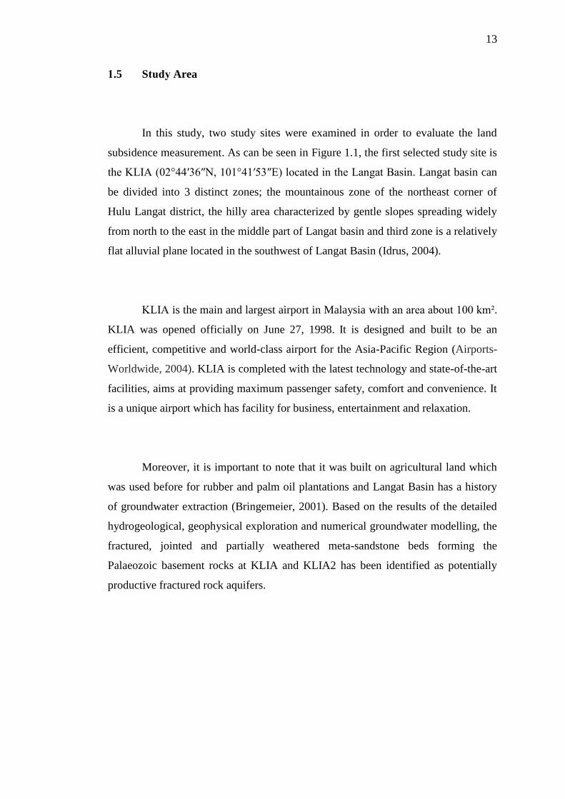
1.5 Study Area
In this study, two study sites were examined in order to evaluate the land
subsidence measurement. As can be seen in Figure 1.1, the first selected study site is
the KLIA (02°44′36″N, 101°41′53″E) located in the Langat Basin. Langat basin can
be divided into 3 distinct zones; the mountainous zone of the northeast corner of
Hulu Langat district, the hilly area characterized by gentle slopes spreading widely
from north to the east in the middle part of Langat basin and third zone is a relatively
flat alluvial plane located in the southwest of Langat Basin (Idrus, 2004).
KLIA is the main and largest airport in Malaysia with an area about 100 km².
KLIA was opened officially on June 27, 1998. It is designed and built to be an
efficient, competitive and world-class airport for the Asia-Pacific Region (Airports-
Worldwide, 2004). KLIA is completed with the latest technology and state-of-the-art
facilities, aims at providing maximum passenger safety, comfort and convenience. It
is a unique airport which has facility for business, entertainment and relaxation.
Moreover, it is important to note that it was built on agricultural land which
was used before for rubber and palm oil plantations and Langat Basin has a history
of groundwater extraction (Bringemeier, 2001). Based on the results of the detailed
hydrogeological, geophysical exploration and numerical groundwater modelling, the
fractured, jointed and partially weathered meta-sandstone beds forming the
Palaeozoic basement rocks at KLIA and KLIA2 has been identified as potentially
productive fractured rock aquifers.
14
Figure 1.1 Map of Langat Basin (Source: Bringemeier, 2001)
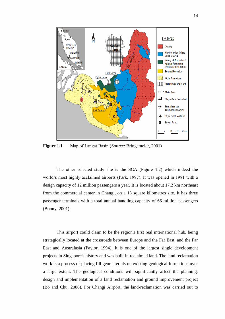
The other selected study site is the SCA (Figure 1.2) which indeed the
world’s most highly acclaimed airports (Park, 1997). It was opened in 1981 with a
design capacity of 12 million passengers a year. It is located about 17.2 km northeast
from the commercial center in Changi, on a 13 square kilometres site. It has three
passenger terminals with a total annual handling capacity of 66 million passengers
(Bonny, 2001).
This airport could claim to be the region's first real international hub, being
strategically located at the crossroads between Europe and the Far East, and the Far
East and Australasia (Paylor, 1994). It is one of the largest single development
projects in Singapore's history and was built in reclaimed land. The land reclamation
work is a process of placing fill geomaterials on existing geological formations over
a large extent. The geological conditions will significantly affect the planning,
design and implementation of a land reclamation and ground improvement project
(Bo and Chu, 2006). For Changi Airport, the land-reclamation was carried out to
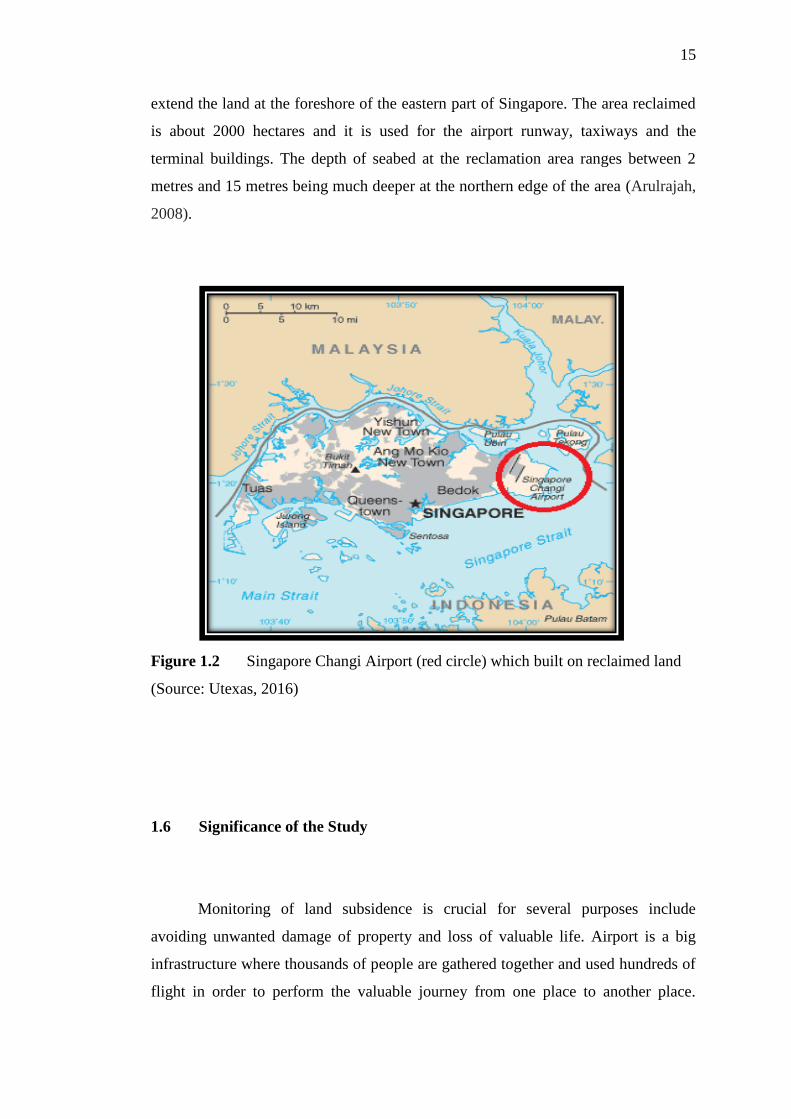
15
extend the land at the foreshore of the eastern part of Singapore. The area reclaimed
is about 2000 hectares and it is used for the airport runway, taxiways and the
terminal buildings. The depth of seabed at the reclamation area ranges between 2
metres and 15 metres being much deeper at the northern edge of the area (Arulrajah,
2008).
Figure 1.2 Singapore Changi Airport (red circle) which built on reclaimed land
(Source: Utexas, 2016)
1.6 Significance of the Study
Monitoring of land subsidence is crucial for several purposes include
avoiding unwanted damage of property and loss of valuable life. Airport is a big
infrastructure where thousands of people are gathered together and used hundreds of
flight in order to perform the valuable journey from one place to another place.

16
Ground surface of an airport especially the runway is very important and sensitive
part. Any unexpected land subsidence at the runway or ground surface can cause
severe threat to human life and property. Therefore, an airport needs to be monitored
for land subsidence with an effective technique.
This study is going to find out and efficient technique for the monitoring of
land subsidence of two busiest airports in Southeast Asian region, hence,
undoubtedly this research is important and would be beneficial for Malaysia and
Singapore and also for several agencies, in particular for those who are interested in
land subsidence monitoring. Some of the specific significance of this study can be
highlighted as follows:
1 As a new technique, the result can be very useful to improve the
monitoring system of airport in Malaysia and Singapore and can obtain a
great level of accuracy.
2 It can improve capability to predict future subsidence in new area or in
the existing land subsidence areas at the airports.
3 This study would be very helpful for the airport management in order to
detect the potential location of suspected subsidence area.
4 The method will be very useful source for any agencies who are
interested to apply this method for the other airports or other
infrastructures in Malaysia and Singapore.
5 As a reference for future research to explore more about InSAR technique
for other purposes like landslide which occurs frequently in Malaysia.
17
1.7 Thesis Outline
This thesis has been divided into six chapters which are as follows:
Chapter 1 provides general overview of the main topic of this research work,
problem statement, research identification which includes research aim, objective
and research questions, scope of the study, study area and significance of the
study.
Chapter 2 provide a literature review on related works including the InSAR
technique, error in InSAR data like tropospheric and orbital effects, the used of
SBAS and MInTS technique and also previous method used in order to correct
both effects and the land subsidence monitoring at airports.
Chapter 3 the methodology and details about the data processing and datasets
are explained. The parameters related to this topic are described and advantages
and disadvantages for the chosen method are stated in this chapter.
Chapter 4 the results and analysis of the processing were shown which include
the DInSAR generation, the corrected interferogram after the tropospheric and
orbital correction were applied and the time series results for both technique.
Chapter 5 the overall process from the start to end and the possible reasons for
what is happening based on the results were discussed.
Chapter 6 the conclusion and recommendation for this thesis were drawn.
175
REFERENCES
Abdelfattah, R. (2009). InSAR phase analysis: Phase unwrapping for noisy SAR
interferograms. INTECH Open Access Publisher.
Abidin, H. Z., Andreas, H., Gumilar, I., Sidiq, T. P., Gamal, M., Murdohardono, D.,
and Supriyadi, Y. F. (2010). Studying land subsidence in Semarang (Indonesia)
using geodetic methods. In FIG Congress, Facing the Challenges—Building the
Capacity, Sydney, Australia.
Abidin, H. Z., Andreas, H., Kato, T., Ito, T., Meilano, I., Kimata, F., and Harjono, H.
(2009). Crustal deformation studies in Java (Indonesia) using GPS. Journal of
Earthquake and Tsunami, 3(02). 77-88.
Agram, P. S., Jolivet, R., Riel, B., Lin, Y. N., Simons, M., Hetland, E., and Lasserre,
C. (2013). New radar interferometric time series analysis toolbox released. Eos,
Transactions American Geophysical Union, 94(7). 69-70.
Agram, P., Jolivet, R., Simons, M., and Riel, B. (2012). GIAnT-Generic InSAR
Analysis Toolbox. In AGU Fall Meeting Abstracts. 1,0897.
Ai, B., Liu, K., Li, X., and Li, D. H. (2008). Flat-earth phase removal algorithm
improved with frequency information of interferogram. In Geoinformatics 2008
and Joint Conference on GIS and Built Environment: Classification of Remote
Sensing Images (pp. 71471A-71471A). International Society for Optics and
Photonics.
Airports-Worldwide (2004), retrieved on 4 June 2014 from http://www.airports-
worldwide.com/malaysia/kuala_lumpur_intl_malaysia.php
Aly, M. H., Zebker, H. A., Giardino, J. R., and Klein, A. G. (2009). Permanent
Scatterer investigation of land subsidence in Greater Cairo, Egypt. Geophysical
Journal International, 178(3). 1238-1245.

176
Amelung, F., Oppenheimer, C., Segall, P., and Zebker, H. (2000). Ground
deformation near Gada ‘Ale Volcano, Afar, observed by radar interferometry.
Geophysical research letters, 27(19). 3093-3096.
Amelung, F., Yun, S. H., Walter, T. R., Segall, P., and Kim, S. W. (2007). Stress
control of deep rift intrusion at Mauna Loa volcano,
Hawaii. Science, 316(5827). 1026-1030.
Aobpaet, A., Cuenca, M. C., Hooper, A., and Trisirisatayawong, I. (2013). InSAR
time-series analysis of land subsidence in Bangkok, Thailand. International
Journal of Remote Sensing, 34(8). 2969-2982.
API (2015) retrieved on 31 January, 2015 from
http://www.pybytes.com/pywavelets/ref/idwt-inverse-discrete-wavelet-
transform.html
Arangio, S., Calò, F., Di Mauro, M., Bonano, M., Marsella, M., and Manunta, M.
(2014). An application of the SBAS-DInSAR technique for the assessment of
structural damage in the city of Rome. Structure and Infrastructure
Engineering, 10(11), 1469-1483.
Arnaud, A., Adam, N., Hanssen, R., Inglada, J., Duro, J., Closa, J. and Eineder, M.,
(2003). ASAR ERS interferometric phase continuity. InGeoscience and Remote
Sensing Symposium, 2003. IGARSS'03. Proceedings. 2003 IEEE
International (Vol. 2, pp. 1133-1135).
Arulrajah, A., Bo, M. W., and Nikraz, H. (2008). Case Study of the Changi East
Land Reclamation Project, Singapore.
ASF (2016) retrieved on 4 March 2016 from https://www.asf.alaska.edu/sar-
data/insar/
Bähr, H., and Hanssen, R. F. (2012). Reliable estimation of orbit errors in
spaceborne SAR interferometry. Journal of Geodesy, 86(12), 1147-1164.
Balaji, P. M. (2011). Estimation and Correction of Tropospheric and Ionospheric
Effects on Differential SAR Interferograms. M. Sc., Indian Institute of Remote
Sensing (IIRS) and International Institute for Geoinformation Science and Earth
Observation (ITC).
Bamler, R., and Hartl, P. (1998). Synthetic aperture radar interferometry. Inverse
problems, 14(4). R1.
Baran, I., Stewart, M. P., Kampes, B. M., Perski, Z., and Lilly, P. (2003). A
modification to the Goldstein radar interferogram filter. IEEE Transactions on
Geoscience and Remote Sensing, 41(9). 2114-2118.
177
Bateson, L., Cigna, F., Boon, D., and Sowter, A. (2015). The application of the
Intermittent SBAS (ISBAS) InSAR method to the South Wales Coalfield,
UK.International Journal of Applied Earth Observation and
Geoinformation, 34, 249-257.
Bayuaji, L., Sumantyo, J. T. S., and Kuze, H. (2010). ALOS PALSAR D-InSAR for
land subsidence mapping in Jakarta, Indonesia. Canadian Journal of Remote
Sensing, 36(1). 1-8.
Bechor, N. B., and Zebker, H. A. (2006). Measuring two‐dimensional movements
using a single InSAR pair. Geophysical research letters, 33(16).
Béjar-Pizarro, M., Socquet, A., Armijo, R., Carrizo, D., Genrich, J., and Simons, M.
(2013). Andean structural control on interseismic coupling in the North Chile
subduction zone. Nature Geoscience, 6(6), 462-467.
Bekaert, D. P., Hooper, A. J., Pathier, E., and Yun, S. (2010). InSAR time series
analysis of the 2006 slow slip event on the Guerrero Subduction Zone, Mexico.
In AGU Fall Meeting Abstracts (Vol. 1, p. 03).
Bell, J. W., Amelung, F., Ferretti, A., Bianchi, M., and Novali, F. (2008). Permanent
scatterer InSAR reveals seasonal and long‐term aquifer‐system response to
groundwater pumping and artificial recharge. Water Resources Research, 44(2).
Berardino, P. G. Fornaro, R. Lanari, E. Sansosti (2002). A new algorithm for surface
deformation monitoring based on small baseline differential SAR
interferograms. IEEE Transactions on Geoscience and Remote Sensing. 40,
2375–2383
Bhanumurthy, V., Manjusree, P., Srinivasa, Rao, G., (2010). Flood disaster
management. In remote sensing applications, Roy, P.S., Dwivedi, R.S., Vijayan,
D., (eds). National Remote Sensing Centre, India.
Bhattacharya, A. K. (2013). An analysis of land subsidence in Bangkok and Kolkata
due to over-extraction of groundwater. Electronic Journal of Geotechnical
Engineering, 18, 1683-1694.
Biggs, J., Bergman, E., Emmerson, B., Funning, G. J., Jackson, J., Parsons, B., and
Wright, T. J. (2006). Fault identification for buried strike-slip earthquakes using
InSAR: The 1994 and 2004 Al Hoceima, Morocco earthquakes. Geophysical
Journal International, 166(3). 1347-1362.

178
Biggs, J., Wright, T., Lu, Z., and Parsons, B. (2007). Multi-interferogram method for
measuring interseismic deformation: Denali Fault, Alaska. Geophysical Journal
International, 170(3). 1165-1179.
Bilko, (2010) retrieved 23 June 2014, from
ftp://ftp.noc.soton.ac.uk/mopedftp/extrabilkodata/EnvSchool_2010_Bilko/EO_
material/d1_SAR_land_apps_lesson/sar_land_apps_1_theory.pdf
Bo, M. W., and Chu, J. (2006). Impact of geological conditions on ground
improvement projects. IAEG2006 The Geological Society of London 2006
Paper number 503
Bo, M. W., Bawajee, R. and Choa, V. (2001). “Reclamation using dredged
materials”. Proceedings of the international conference on Port and Maritime R
and D and Technology, Singapore, Vol.1, pp.455-461.
Bock, Y., Wdowinski, S., Ferretti, A., Novali, F., and Fumagalli, A. (2012). Recent
subsidence of the Venice Lagoon from continuous GPS and interferometric
synthetic aperture radar. Geochemistry, Geophysics, Geosystems, 13(3).
Bonny, M. Tan. (2001) retrieved on 4 August 2014 from
http://eresources.nlb.gov.sg/infopedia/articles/SIP_574_2004-12-23.html
Brigham, C. I. Kolkowitz, M. Dolson, J. Rudy, A. Brooks, C. Hiatt, C. Schmidt, and
J. W. Skiles. (2006) Object-Oriented Analysis of Sea Ice Fragmentation Using
SAR Imagery to Determine Pacific Walrus Habitat. AGU Fall Meeting, Dec. 11-
15, San Francisco , CA .
Bringemeier, D. (2001). Evaluation of the effects on the groundwater regimes due to
groundwater withdrawal at Bukit Tadom, Mukim of Tanjung Dua Belas, Kuala
Langat District, Selangor Darul Ehsan, prepared for Perunding Utama Sdn Bhd,
unpublished
Buckheit, J. B., and D. L. Donoho (1995). WaveLab and reproducible research,
report, 27 pp., Dep. of Stat., Stanford Univ., Stanford, California
Budhu, M., and Adiyaman, I. (2013). The influence of clay zones on land subsidence
from groundwater pumping. Groundwater, 51(1). 51-57.
Bürgmann, R., Rosen, P. A., and Fielding, E. J. (2000). Synthetic aperture radar
interferometry to measure Earth's surface topography and its deformation.
Annual Review of Earth and Planetary Sciences, 28(1), 169-209.
179
Bürgmann, R., D. Schmidt, R. M. Nadeau, M. d'Alessio, E. Fielding, D. Manaker, T.
V. McEvilly, and M. H. Murray (2000). Earthquake potential along the northern
Hayward fault, California, Science, 289, 1178–1182.
Cai, G., Zhang, A., Zhuo, S., Feng, D., and Sun, M. (2013). An Algorithm of
Filtering InSAR Interferogram Based on the Combination of Wavelet Transform
and Sigma Filter. International Conference on Remote Sensing, Environment
and Transportation Engineering (RSETE 2013). Atlantis Press.
Calderhead, A. I., Therrien, R., Rivera, A., Martel, R., and Garfias, J. (2011).
Simulating pumping-induced regional land subsidence with the use of InSAR
and field data in the Toluca Valley, Mexico. Advances in Water
Resources,34(1). 83-97.
Cao, L., Zhang, Y., He, J., Liu, G., Yue, H., Wang, R., and Ge, L. (2008). Coal Mine
Land Subsidence Monitoring By Using Spaceborne Insar Data-A Case Study In
Fengfeng, Hebei Province, China. Int. Arch. Photogramm. Remote Sens. Spat.
Inf. Sci, 37, 255-261.
Capková, I., David, D., and Halounová, L. (2007). Detecting land deformation in the
area of northern bohemia using insar stacks (preliminary results). In
Proceedings of (Vol. 25).
Capková, I., Kianicka, J., and Halounová, L. (2005). New results of interferometric
processing of the northern Bohemia scenes.
Casu, F. (2009) The Small Baseline Subset technique: performance assessment and
new developments for surface deformation analysis of very extended areas.
Ph.D. in Electronic and Computer Engineering Dept. of Electrical and
Electronic Engineering University of Cagliari
Casu, F., Manzo, M., Lanari, R.A. (2006). Quantitative assessment of the SBAS
algorithm performance for surface deformation retrieval from DInSAR data J.
Remote Sens. Environ., 102 pp. 195–210
Catalao, J., Raju, D., and Fernandes, R. M. S. (2013). Mapping Vertical Land
Movement In Singapore Using InSAR GPS. In ESA Special Publication (Vol.
722, p. 54).
Cavalié, O., Lasserre, C., Doin, M. P., Peltzer, G., Sun, J., Xu, X., and Shen, Z. K.
(2008). Measurement of interseismic strain across the Haiyuan fault (Gansu,
China). by InSAR. Earth and Planetary Science Letters, 275(3). 246-257.

180
Chand, F. (1998). Environmental Geology in Urban Development. Proc. Geosea, 98,
329-335.
Chapin, E., Chan, S. F., Chapman, B. D., Chen, C. W., Martin, J. M., Michel, T. R.,
and Rosen, P. A. (2006). Impact of the ionosphere on an L-band space based
radar. In Radar, 2006 IEEE Conference on (pp. 8-pp).
Chatterjee RS, Lakhera RC, Dadhwal VK (2010) InSAR coherence and phase
information for mapping environmental indicators of opencast coal mining: a
case study in Jharia Coalfield, Jharkhand, India. Can J Rem Sens 36:361–373
Chaussard, E., Amelung, F., Abidin, H., and Hong, S. H. (2013). Sinking cities in
Indonesia: ALOS PALSAR detects rapid subsidence due to groundwater and gas
extraction. Remote Sensing of Environment, 128, 150-161.
Chaussard, E., Wdowinski, S., Cabral-Cano, E., and Amelung, F. (2014). Land
subsidence in central Mexico detected by ALOS InSAR time-series. Remote
Sensing of Environment, 140, 94-106.
Chen, A. C., and Zebker, H. A. (2014). Reducing ionospheric effects in InSAR data
using accurate coregistration. IEEE transactions on geoscience and remote
sensing, 52(1). 60-70.
Chen, C. and Zebker, H. (2000). Network approaches to two-dimensional phase
unwrapping: intractability and two new algorithms. Journal of the Optical
Society of America A, 17: 401–414.
Chen, C. W., and Zebker, H. A. (2001). Two-dimensional phase unwrapping with
use of statistical models for cost functions in nonlinear optimization. JOSA A,
18(2), 338-351.
Chen, C. W., and Zebker, H. A. (2002). Phase unwrapping for large SAR
interferograms: statistical segmentation and generalized network
models.Geoscience and Remote Sensing, IEEE Transactions on, 40(8). 1709-
1719.
Chen, J., and Zebker, H. A. (2012). Ionospheric artifacts in simultaneous L-band
InSAR and GPS observations. Geoscience and Remote Sensing, IEEE
Transactions on, 50(4). 1227-1239.
Choa, V. (1994). Application of the observational method to hydraulic fill
reclamation projects. Geotechnique, 44(4). 735-745.

181
Colesanti, C., Ferretti, A., Prati, C., and Rocca, F. (2003). Monitoring landslides and
tectonic motions with the Permanent Scatterers Technique. Engineering
Geology, 68(1). 3-14.
Çomut, F. C., Üstün, A. (2012) Impact of Perpendicular and Temporal Baseline
Characteristics on InSAR Coherence Maps. TurkeyFIG Working Week:
Knowing to manage the territory, protect the environment, evaluate the cultural
heritage. Rome, Italy.
Crosetto, M., Biescas, E., Duro, J., Closa, J., and Arnaud, A. (2008). Generation of
advanced ERS and Envisat interferometric SAR products using the stable point
network technique. Photogrammetric Engineering and Remote Sensing, 74(4),
443-450.
Dammert, P. B. G., (1996). Accuracy of INSAR measurements in forested areas. In
Proceedings of ESA Fringe Workshop on ERS SAR Interferometry, Zurich,
Switzerland, (Noordwijk, The Netherlands: ESA). SP-406, pp. 37–49.
Delacourt, C., Briole, P., and Achache, J. A. (1998). Tropospheric corrections of
SAR interferograms with strong topography. Application to Etna. Geophysical
Research Letters, 25(15). 2849-2852.
D'errico, J. R. (1991). U.S. Patent No. 4,992,861. Washington, DC: U.S. Patent and
Trademark Office.
Ding, X. L., Liu, G. X., Li, Z. W., Li, Z. L., and Chen, Y. Q. (2004). Ground
subsidence monitoring in Hong Kong with satellite SAR
interferometry.Photogrammetric Engineering and Remote Sensing, 70(10).
1151-1156.
Doin, M. P., Lasserre, C., Peltzer, G., Cavalié, O., and Doubre, C. (2009).
Corrections of stratified tropospheric delays in SAR interferometry: Validation
with global atmospheric models. Journal of Applied Geophysics, 69(1). 35-50.
Dong, S., Samsonov, S., Yin, H., Ye, S., and Cao, Y. (2014). Time-series analysis of
subsidence associated with rapid urbanization in Shanghai, China measured with
SBAS InSAR method. Environmental earth sciences, 72(3), 677-691.
Earthdef (2016), retrieved on 19 April 2016 from
http://earthdef.caltech.edu/attachments/246/20101120.xml
Eichel, C., Krämer, M., Schütz, L., and Wurzler, S. (1996). The water‐soluble
fraction of atmospheric aerosol particles and its influence on cloud

182
microphysics. Journal of Geophysical Research: Atmospheres (1984–
2012).101(D23). 29499-29510.
Eineder M., Minet C., Steigenberger P., Cong X.,and Fritz T. (2011). Imaging
geodesy—toward centimeter-level ranging accuracy with TerraSAR-X. IEEE
Trans. Geosci. Remote Sens.; 49(2):661-671
Eineder, M. (2003). Problems and solutions for InSAR digital elevation model
generation of mountainous terrain. In ESA FRINGE workshop, ESA, Frascati.
ESA (2013) retrieved on 31 December, 2013 from
http://www.esa.int/Education/Educational_material_from_ESA
Fan, H., Deng, K., Ju, C., Zhu, C., and Xue, J. (2011). Land subsidence monitoring
by D-InSAR technique. Mining Science and Technology (China).21(6). 869-
872.
Farooque, M.A. and Rohankar, J.S., (2013). Survey on various noises and techniques
for denoising the color image. International Journal of Application or
Innovation in Engineering and Management (IJAIEM), 2(11), pp.217-221.
Fattahi, H., and Amelung, F. (2013). DEM error correction in InSAR time
series.Geoscience and Remote Sensing, IEEE Transactions on, 51(7). 4249-
4259.
Fattahi, H., and Amelung, F. (2014). InSAR uncertainty due to orbital
errors.Geophysical Journal International, 199(1). 549-560.
Feng, G. (2011). Coseismic deformation and ionospheric variation associated with
Wenchuan earthquake estimated from InSAR. Doctoral dissertation, The Hong
Kong Polytechnic University.
Feng, G., Ding, X., Li, Z., Mi, J., Zhang, L., and Omura, M. (2012). Calibration of
an InSAR-derived coseimic deformation map associated with the 2011 Mw-9.0
Tohoku-Oki earthquake. Geoscience and Remote Sensing Letters, IEEE, 9(2).
302-306.
Feng, G., Hetland, E. A., Ding, X., Li, Z., and Zhang, L. (2010). Coseismic fault slip
of the 2008 Mw 7.9 Wenchuan earthquake estimated from InSAR and GPS
measurements. Geophysical research letters, 37(1).
Ferretti, A., C. Prati, and F. Rocca, (1999). Monitoring terrain deformation using
multi-temporal SAR images, Proceedings of the CEOS SAR Workshop, 26-29
October, Toulouse, France, (on CD ROM)
183
Ferretti, A., Prati, C., and Rocca, F. (1999). Multibaseline InSAR DEM
reconstruction: The wavelet approach. IEEE Transactions on Geoscience and
Remote Sensing, 37(2), 705-715.
Ferretti, A., Prati, C., and Rocca, F. (2000). Nonlinear subsidence rate estimation
using permanent scatterers in differential SAR interferometry. Geoscience and
Remote Sensing, IEEE transactions on, 38(5). 2202-2212.
Ferretti, A., Prati, C., and Rocca, F. (2001). Permanent scatterers in SAR
interferometry. Geoscience and Remote Sensing, IEEE Transactions on, 39(1).
8-20.
Ferretti, A., Savio, G., Barzaghi, R., Borghi, A., Musazzi, S., Novali, F., and Rocca,
F. (2007). Submillimeter accuracy of InSAR time series: Experimental
validation. IEEE Transactions on Geoscience and Remote Sensing, 45(5), 1142-
1153.
Fialko, Y., Sandwell, D., Simons, M., and Rosen, P. (2005). Three-dimensional
deformation caused by the Bam, Iran, earthquake and the origin of shallow slip
deficit. Nature, 435(7040). 295-299.
Fraczek, W. (2003). Mean sea level, GPS, and the geoid. ArcUsers Online.
Franceschetti, G., and Lanari, R. (1999). Synthetic aperture radar processing. CRC
press.
Frei U., C. Graf, and E. Meier, (1993). Cartographic reference system, Chapter 10 in
SAR-Geocoding - Data and Systems, WichmannVerlag, edited by Schreier,.
Frost, V. S., Stiles, J. A., Shanmugan, K. S., and Holtzman, J. (1982). A model for
radar images and its application to adaptive digital filtering of multiplicative
noise. Pattern Analysis and Machine Intelligence, IEEE Transactions on, (2).
157-166.
Fruneau, B., J.P. Rudant, D. Obert, and D. Raymond, (1999). Small displacements
detected by SAR interferometry on the City of Paris (France). Proceedings of
IGARSS'99, 28 June-02 July, Hamburg, Germany, (on CD ROM)
Gabriel, A. K., Goldstein, R. M., and Zebker, H. A. (1989). Mapping small elevation
changes over large areas: differential radar interferometry. Journal of
Geophysical Research: Solid Earth (1978–2012). 94(B7). 9183-9191.
Galloway, D. L., D. R. Jones, and S. E. Ingebritsen, (1999). Land subsidence in the
United States, U.S. Geol. Surv. Circ. 1182.
184
Gatelli, F., Guamieri, A. M., Parizzi, F., Pasquali, P., Prati, C., and Rocca, F. (1994).
The wavenumber shift in SAR interferometry. Geoscience and Remote Sensing,
IEEE Transactions on, 32(4). 855-865.
Ge, L., Chang, H. C., and Rizos, C. (2004). Satellite radar interferometry for mine
subsidence monitoring. In 22nd Australian Institute of Mine Surveyors Annual
Seminar.
Ghiglia, D. and Romero, L., (1994). Robust two-dimensional weighted and
unweighted phase unwrapping using fast transforms and iterative methods, J.
Opt. Soc. Am. A, 11, 107–117
Gili, J. A., Corominas, J., and Rius, J. (2000). Using Global Positioning System
techniques in landslide monitoring. Engineering Geology, 55(3). 167-192.
GIM (2016) retrieved on 28 June 2016 from http://www.gim-
international.com/content/article/satellite-radar-interferometry
Goldstein, R. M., and C. L. Werner, (1997) Radar Ice Motion Interferometry, Proc. 3
ERS ESA Symposium, ESA SP-JiJ, 969-972,
Goldstein, R. M., and Werner, C. L. (1998). Radar interferogram filtering for
geophysical applications. Geophysical Research Letters, 25(21). 4035-4038.
Goldstein, R. M., Engelhardt, H., Kamb, B., and Frolich, R. M. (1993). Satellite
radar interferometry for monitoring ice sheet motion: application to an Antarctic
ice stream. Science, 262(5139). 1525-1530.
Goldstein, R. M., Zebker, H. A., and Werner, C. L. (1988). Satellite radar
interferometry: Two‐dimensional phase unwrapping. Radio science, 23(4). 713-
720.
Goudarzi, M.A., (2010). Detection and measurement of land deformations caused by
seismic events using InSAR, sub-pixel correlation and inversion techniques.
Thesis (MSc). University of Twente Faculty of Geo-Information and Earth
Observation (ITC). pp 127.
Gourmelen, N., Amelung, F., and Lanari, R. (2010). Interferometric synthetic
aperture radar–GPS integration: Interseismic strain accumulation across the
Hunter Mountain fault in the eastern California shear zone. Journal of
Geophysical Research: Solid Earth (1978–2012). 115(B9).
Gourmelen, N., Amelung, F., Casu, F., Manzo, M., and Lanari, R. (2007). Mining‐
related ground deformation in Crescent Valley, Nevada: Implications for sparse
GPS networks. Geophysical Research Letters, 34(9).
185
Graham, L. C. (1974). Synthetic interferometer radar for topographic
mapping. Proceedings of the IEEE, 62(6), 763-768.
Graham, J., and Yin, J. H. (2001). On the time-dependent stress-strain behaviour of
soft soils. Soft Soil Engineering, 13-23.
GSI, 2004 retrieved on 2 February, 2014 from
http://vldb.gsi.go.jp/sokuchi/sar/mechanism/mechanism03-e.html
Gupta, P., R. Hasan, and U. Kumar. (2009). Big Reforms but Small Payoffs:
Explaining the Weak Record of Growth in Indian Manufacturing, S. Bery, B.
Bosworth, and A. Panagariya (eds). India Policy Forum, volume 5, pp 59-108.
Hanssen, R. F. (2001). Radar interferometry: data interpretation and error
analysis (Vol. 2). Springer Science and Business Media.
Hanssen, R. F., and Klees, R. (1998). Applications of SAR Interferometry In
Terrestrial And Atmospheric Mapping. In European Microwave week (pp. 5-9).
Hauser, J. P. (1989). Effects of deviations from hydrostatic equilibrium on
atmospheric corrections to satellite and lunar laser range measurements.Journal
of Geophysical Research: Solid Earth, 94(B8), 10182-10186.
Hellwich, O. (1999). Basic principles and current issues of SAR interferometry.
In Joint Workshop of ISPRS WGI/1, I/3 and IV/4, Sensors and Mapping from
Space.
Herrera, G., Toms, R., Lopez-Sanchez, J.M., Delgado, J., Mallorqui, J.J., Duque, S.
and Mulas, J., (2007). Advanced DInSAR analysis on mining area : La Union
case study (Murcia, SE Sapin). Engineering Geology, 90, 148−159 p.
Hetland, E. A., Musé, P., Simons, M., Lin, Y. N., Agram, P. S., and DiCaprio, C. J.
(2012). Multiscale InSAR time series (MInTS) analysis of surface
deformation. Journal of Geophysical Research: Solid Earth (1978–
2012).117(B2).
Hooper, A. (2008). A multi‐temporal InSAR method incorporating both persistent
scatterer and small baseline approaches. Geophysical Research Letters, 35(16).
Hooper, A., and Zebker, H. A. (2007). Phase unwrapping in three dimensions with
application to InSAR time series. JOSA A, 24(9), 2737-2747.
Hooper, A., Zebker, H., Segall, P., and Kampes, B. (2004). A new method for
measuring deformation on volcanoes and other natural terrains using InSAR
persistent scatterers. Geophysical research letters, 31(23).

186
Hsu, Y. Y., Gonzalez, M., Bossuyt, F., Axisa, F., Vanfleteren, J., and De Wolf, I.
(2010). The effect of pitch on deformation behavior and the stretching-induced
failure of a polymer-encapsulated stretchable circuit. Journal of
Micromechanics and Microengineering, 20(7), 075036.
Hu, J., Li, Z. W., Ding, X. L., Zhu, J. J., Zhang, L., and Sun, Q. (2014). Resolving
three-dimensional surface displacements from InSAR measurements: A
review. Earth-Science Reviews, 133, 1-17.
Huby, M. (2001). The sustainable use of resources on a global scale. Social Policy
and Administration, 35(5). 521-537.
Idrus, S., Abdul, H. H. S., and Ahmad, F. M., (2004). Analyses of Land Use and
Land Cover Changes 1974-2001 In Langat Basin, Malaysia Using Geographical
Information System (GIS). Proceedings Of The 2003 Langat Basin Ecosystem
research Symposium. Penerbit LESTARI, UKM.
Ikehara, M. E., and Phillips Steven, P. (1994). Determination of Land Subsidence
Related to Ground-Water-Level Declines Using GPS and Leveling Surveys in
Antelope Valley, California 1992. US Geological Survey, Water Resources
Investigations Report, 4184.
Imakiire, T., and Koarai, M. (2012). Wide-area land subsidence caused by “the 2011
Off the Pacific Coast of Tohoku Earthquake”. Soils and Foundations,52(5). 842-
855.
Jehle, M., Small, D., Meier, E., and Nüesch, D. (2004). Improved knowledge of SAR
geometry through atmospheric modelling. In Proc. EUSAR (Vol. 3).
Jiang, L., and Lin, H. (2010). Integrated analysis of SAR interferometric and
geological data for investigating long-term reclamation settlement of Chek Lap
Kok Airport, Hong Kong. Engineering Geology, 110(3). 77-92.
Jolivet, R., Agram, P. S., Lin, N. Y., Simons, M., Doin, M. P., Peltzer, G., and Li, Z.
(2014). Improving InSAR geodesy using global atmospheric models.Journal of
Geophysical Research: Solid Earth, 119(3), 2324-2341.
Jolivet, R., Grandin, R., Lasserre, C., Doin, M. P., and Peltzer, G. (2011). Systematic
InSAR tropospheric phase delay corrections from global meteorological
reanalysis data. Geophysical Research Letters, 38(17).
Joughin, I., Tulaczyk, S., Fahnestock, M., and Kwok, R. (1996). A mini-surge on the
Ryder Glacier, Greenland, observed by satellite radar
interferometry.Science, 274(5285). 228-230.
187
Joyce, K. E., Belliss, S. E., Samsonov, S. V., McNeill, S. J., and Glassey, P. J.
(2009). A review of the status of satellite remote sensing and image processing
techniques for mapping natural hazards and disasters. Progress in Physical
Geography.
Jung, H. S., Lee, D. T., Lu, Z., and Won, J. S. (2013). Ionospheric correction of SAR
interferograms by multiple-aperture interferometry. Geoscience and Remote
Sensing, IEEE Transactions on, 51(5). 3191-3199.
Jung, H. S., Won, J. S., and Kim, S. W. (2009). An improvement of the performance
of multiple-aperture SAR interferometry (MAI). Geoscience and Remote
Sensing, IEEE Transactions on, 47(8). 2859-2869.
Kampes, B. M. (2005). Displacement parameter estimation using permanent
scatterer interferometry, Doctoral dissertation, TU Delft, Delft University of
Technology.
Kampes, B. M. (2006). Radar Interferometry. Springer.
Kaneko, Y., Y. Fialko, D. T. Sandwell, X. Tong, and M. Furuya (2013). Interseismic
deformation and creep along the central section of the North Anatolian fault
(Turkey): InSAR observations and implications for rate-and-state friction
properties, J. Geophys. Res. Solid Earth, 118, 316–331.
Karunaratne G P, Yong K Y, Tan T S, Tan S A, Liang K. M, Lee S L and
Vijiaratnam A. (1990). Layered clay-sand scheme reclamation at Changi South
Bay. Proc. 10th Southeast Asian Geotech. Conf, Taipei,1, 71–76.
Katen, A. T., Kampes, B., and Bree, R. V. (2001). Tianjin InSAR Land Subsidence
Observation Demonstration project. Delft University Delft.
Kausika, B. B. (2013). Polarimetric Modeling of Lunar Surface for Scattering
Information Retrieval Using Mini-SAR Data of CHANDRAYAAN-1. M. Sc.
dissertation, University of Twente, Enschede, The Netherlands,, 30.
Keeratikasikorn, C., and Trisirisatayawong, I. (2011). A Method to Use Modis Water
Vapor Products For Correction of Atmospheric-Induced Phase in
Interferogram. Artificial Satellites, 46(2), 47-62.
Knospe, S., and Jonsson, S. (2010). Covariance estimation for dInSAR surface
deformation measurements in the presence of anisotropic atmospheric
noise. IEEE Transactions on Geoscience and Remote Sensing,48(4), 2057-2065.
Kociołek, M., Materka, A., Strzelecki, M., and Szczypiński, P. (2001). Discrete
wavelet transform-derived features for digital image texture analysis.
188
In International Conference on Signals and Electronic Systems, Łódź-
Poland (pp. 99-104).
Kohlhase, A. O., Feigl, K. L., and Massonnet, D. (2003). Applying differential
InSAR to orbital dynamics: a new approach for estimating ERS
trajectories.Journal of Geodesy, 77(9). 493-502.
Lanari, R., Casu, F., Manzo, M., Zeni, G., Berardino, P., Manunta, M., and Pepe, A.
(2007). An overview of the small baseline subset algorithm: A DInSAR
technique for surface deformation analysis. Pure and Applied
Geophysics, 164(4). 637-661.
Lanari, R., Fornaro, G., Riccio, D., Migliaccio, M., Papathanassiou, K. P., Moreira,
J. R., and Coltelli, M. (1996). Generation of digital elevation models by using
SIR-C/X-SAR multifrequency two-pass interferometry: the Etna case
study. Geoscience and Remote Sensing, IEEE Transactions on, 34(5). 1097-
1114.
Lanari, R., Lundgren, P., Manzo, M., and Casu, F. (2004). Satellite radar
interferometry time series analysis of surface deformation for Los Angeles,
California. Geophysical Research Letters, 31(23).
Lauknes, T. R (2010) Rockslide Mapping in Norway by Means of Interferometric
SAR Time Series Analysis, A dissertation for the degree of Philosophiae Doctor,
Faculty Of Science Department Of Physics And Technology, university of
Tromsø
Lauknes, T. R., Dehls, J., Larsen, Y., Høgda, K. A., and Weydahl, D. J. (2006). A
comparison of SBAS and PS ERS InSAR for subsidence monitoring in Oslo,
Norway. In Fringe 2005 Workshop (Vol. 610).
Leake, S. A. (1997). Land subsidence from ground-water pumping. US Geological
Survey.
Lee C.W., Z. Lu, H.S. Jung, J.S. Won, D. Dzurisin (2010) Surface deformation of
Augustine Volcano (Alaska), 1992–2005, from multiple-interferogram
processing using a refined SBAS InSAR approach. U.S. Geological Survey
Professional Paper 1769, pp. 453–465
Lee J. C and Rho T., (2001) Application to Leveling Using Total Station, New
Technology for a New Century International Conference, FIG Working Week
2001, Seoul, Korea 6–11 May 2001 Session 17 - The Use of Positioning and
Measurement Technology in Engineering and Construction Applications

189
Lee S L, Karunaratne G P, Yong KY, Tan S A, Tan T S and Vijiaratnam A. (1990)
Development in land reclamation. Proc. Convention of Instn. Engr., Singapore,
1990:13-20.
Lee, H. (2001). Interferometric synthetic aperture radar coherence imagery for land
surface change detection (Doctoral dissertation, Huxley School, Imperial
College, London 2001).
Lee, H. (2016) retrieved on 28 January 2016from http://sar.kangwon.ac.kr/
Lee, H., and Liu, J. G. (2000). Topographic phase corrected coherence estimation
using multi-pass differential SAR interferometry: differential coherence.
In Geoscience and Remote Sensing Symposium, 2000. Proceedings. IGARSS
2000. IEEE 2000 International Vol. 2, pp. 776-778.
Lee, Y. L., Kim, H. C., and Park, H. W. (1998). Blocking effect reduction of JPEG
images by signal adaptive filtering. Image Processing, IEEE Transactions
on, 7(2). 229-234.
Leung C F, Wong J C, Manivanann R and Tan S A. (2001). Experimental evaluation
of consolidation behaviour of stiff clay lumps in reclamation fill. Geotech.
Testing J. 2001, 24(2): 145-156.
Li, F. K., and Goldstein, R. M. (1990). Studies of multibaseline spaceborne
interferometric synthetic aperture radars. Geoscience and Remote Sensing, IEEE
Transactions on, 28(1). 88-97.
Li, T., Liu, G., Jia, H., Lin, H., Zhang, R., Yu, B., and Luo, Q. (2013). An Improved
Multi-Temporal Insar Method for Increasing Spatial Resolution of Surface
Deformation Measurements. ISPRS-International Archives of the
Photogrammetry, Remote Sensing and Spatial Information Sciences, 1(2), 145-
150.
Li, Z. (2004). Production of regional 1 km × 1 km water vapor fields through the
integration of GPS and MODIS data, ION GNSS 2004, 21 – 24 Sept, Inst. of
Navig., Long Beach, California.
Li, Z. W., Ding, X. L., Huang, C., Zhu, J. J., and Chen, Y. L. (2008). Improved
filtering parameter determination for the Goldstein radar interferogram filter.
ISPRS Journal of Photogrammetry and Remote Sensing, 63(6). 621-634.
Li, Z., and Bethel, J. (2008). Image coregistration in SAR interferometry. Proc. Int.
Arch. Photogramm., Remote Sens. Spatial Inf. Sci, 433-438.

190
Lin, Y. N. N., Simons, M., Hetland, E. A., Muse, P., and DiCaprio, C. (2010). A
multiscale approach to estimating topographically correlated propagation delays
in radar interferograms. Geochemistry, Geophysics, Geosystems,11(9).
Lin, Z., Huili, G., Xiaojuan, L., Yaoming, S., and Lingling, J. (2009). Research on
driving factors of land subsidence with remote sensing technology.
In Geoscience and Remote Sensing Symposium, 2009 IEEE International,
IGARSS 2009 (Vol. 2, pp. II-396).
Liu, G., Buckley, S. M., Ding, X., Chen, Q., and Luo, X. (2009). Estimating
spatiotemporal ground deformation with improved permanent-scatterer radar
interferometry. Geoscience and Remote Sensing, IEEE Transactions on,47(8).
2762-2772
Liu, G., Ding, X., Chen, Y., Li, Z., and Li, Z. (2001). Ground settlement of Chek
Lap Kok Airport, Hong Kong, detected by satellite synthetic aperture radar
interferometry. Chinese Science Bulletin, 46(21). 1778-1782.
Liu, G., Luo, X., Chen, Q., Huang, D., and Ding, X. (2008). Detecting land
subsidence in Shanghai by PS-networking SAR interferometry. Sensors, 8(8).
4725-4741.
Liu, P. (2012). InSAR observations and modeling of Earth surface displacements in
the Yellow River Delta (China) Doctoral dissertation, University of Glasgow.
Liu, Z., Jung, H. S., and Lu, Z. (2014). Joint correction of ionosphere noise and
orbital error in L-band SAR interferometry of interseismic deformation in
southern California. Geoscience and Remote Sensing, IEEE Transactions
on,52(6). 3421-3427.
Lofgren, J. S., Bjorndahl, F., Moore, A. W., Webb, F. H., Fielding, E. J., and
Fishbein, E. F. (2010). Tropospheric correction for InSAR using interpolated
ECMWF data and GPS Zenith Total Delay from the Southern California
integrated GPS network. In Geoscience and Remote Sensing Symposium
(IGARSS), 2010 IEEE International (pp. 4503-4506).
López-Quiroz, P., Doin, M. P., Tupin, F., Briole, P., and Nicolas, J. M. (2009). Time
series analysis of Mexico City subsidence constrained by radar
interferometry. Journal of Applied Geophysics, 69(1). 1-15.
Lu, Z., and Dzurisin, D. (2014). InSAR Imaging of Aleutian Volcanoes. InInSAR
Imaging of Aleutian Volcanoes (pp. 87-345). Springer Berlin Heidelberg.
191
Lu, Z., Patrick, M., Fielding, E. J., and Trautwein, C. (2003). Lava volume from the
1997 eruption of Okmok volcano, Alaska, estimated from spaceborne and
airborne interferometric synthetic aperture radar. IEEE Trans. Geosci. Remote
Sens, 41(6). 1428-1436.
Lundgren, P., Hetland, E. A., Liu, Z., and Fielding, E. J. (2009). Southern San
Andreas‐San Jacinto fault system slip rates estimated from earthquake cycle
models constrained by GPS and interferometric synthetic aperture radar
observations. Journal of Geophysical Research: Solid Earth, 114(B2).
Luo, Q., Perissin, D., Lin, H., Zhang, Y., and Wang, W. (2014). Subsidence
monitoring of Tianjin suburbs by TerraSAR-X persistent scatterers
interferometry. IEEE Journal of Selected Topics in Applied Earth Observations
and Remote Sensing, 7(5), 1642-1650.
Luzi, G. (2010). Ground based SAR interferometry: a novel tool for Geoscience.
INTECH Open Access Publisher.
Mallat, S. (2008). A Wavelet Tour of Signal Processing: The Sparse Way (3rd
ed.)
Academic, Burlington, Mass.
Manzo, M., Berardino, P., Bonano, M., Casu, F., Manunta, M., Pepe, A., and Lanari,
R. (2012). A quantitative assessment of DInSAR time series accuracy in
volcanic areas: from the first to second generation SAR sensors. In Geoscience
and Remote Sensing Symposium (IGARSS). 2012 IEEE International. pp. 911-
914.
Massonnet, D. (2008). Parachute satellites for earth observation. Acta
Astronautica, 63(1). 411-415.
Massonnet, D., and Feigl, K. L. (1995). Discrimination of geophysical phenomena in
satellite radar interferograms. Geophysical research letters,22(12). 1537-1540.
Massonnet, D., and Feigl, K. L. (1998). Radar interferometry and its application to
changes in the Earth's surface. Reviews of geophysics, 36(4). 441-500.
Massonnet, D., Briole, P., and Arnaud, A. (1995). Deflation of Mount Etna
monitored by spaceborne radar interferometry.
Massonnet, D., Rossi, M., Carmona, C., Adragna, F., Peltzer, G., Feigl, K., and
Rabaute, T. (1993). The displacement field of the Landers earthquake mapped
by radar interferometry. Nature, 364(6433). 138-142.
Meteoblue (2006) retrieved on 28 August 2014 from
https://content.meteoblue.com/en/meteoscool/the-earth/atmosphere

192
Meyer, F., Bamler, R., Jakowski, N., and Fritz, T. (2006). The potential of low-
frequency SAR systems for mapping ionospheric TEC distributions.Geoscience
and Remote Sensing Letters, IEEE, 3(4). 560-564.
Mohr, J. J., Reeh, N., and Madsen, S. N. (1998). Three-dimensional glacial flow and
surface elevation measured with radar interferometry. Nature, 391(6664). 273-
276.
Mora, O., Mallorqui, J. J., and Broquetas, A. (2003). Linear and nonlinear terrain
deformation maps from a reduced set of interferometric SAR images.Geoscience
and Remote Sensing, IEEE Transactions on, 41(10). 2243-2253.
Moreau, F., Dauteuil, O., Bour, O., and Gavrilenko, P. (2006). GPS measurements of
ground deformation induced by water level variations into a granitic aquifer
(French Brittany). Terra Nova, 18(1), 50-54.
Motagh, M., Djamour, Y., Walter, T. R., Wetzel, H. U., Zschau, J., and Arabi, S.
(2007). Land subsidence in Mashhad Valley, northeast Iran: results from InSAR,
levelling and GPS. Geophysical Journal International, 168(2). 518-526.
Muço, B., Alexiev, G., Aliaj, S., Elezi, Z., Grecu, B., Mandrescu, N., Milutinovic,
Z., Radulian, M., Ranguelov, B. and Shkupi, D., (2012). Geohazards assessment
and mapping of some Balkan countries. Natural hazards, 64(2), pp.943-981.
MyMetro (2014) retrieved on 23 May 2014 from
http://www.hmetro.com.my/node/66640
NAP, 2007). retrieved on 2 February, 2014 from
https://books.google.com/books?isbn=0309104092
NEST (2007) Retrieved on 31 December 2013 from
https://earth.esa.int/web/nest/release-notes
Nichols, Jr. T.C. Rebound, its nature and effect on engineering works. 1980.
Quarterly Journal of Engineering Geology. 13133‐152.
Odijk, D., Kenselaar, F., and Hanssen, R. (2003). Integration of leveling and InSAR
data for land subsidence monitoring. In 11th FIG International Symposium on
Deformation Measurements, Santorini, Greece , pp. 23-28.
Ortega‐Guerrero, A., Rudolph, D. L., and Cherry, J. A. (1999). Analysis of long‐
term land subsidence near Mexico City: Field investigations and predictive
modeling. Water Resources Research, 35(11), 3327-3341.
193
Osmanoğlu, B., Dixon, T. H., Wdowinski, S., Cabral-Cano, E., and Jiang, Y. (2011).
Mexico City subsidence observed with persistent scatterer InSAR.International
Journal of Applied Earth Observation and Geoinformation, 13(1), 1-12.
Parbleu, 2007 retrieved on 2 February, 2014 from
http://www.parbleu.biz/remsens.htm
Park, Y. (1997). Application of a fuzzy linguistic approach to analyse Asian airports’
competitiveness. Transportation Planning and Technology, 20(4). 291-309.
Parviz, 2012 retrieved on 2 February, 2014 from
https://parviztarikhi.wordpress.com/features-2/insar-for-aquatic-bodies/
Patidar, P., Gupta, M., Srivastava, S. and Nagawat, A.K., (2010). Image de-noising
by various filters for different noise. International Journal of Computer
Applications (0975–8887) Volume.
Paul Rosen, JPL Eric Fielding, JPL Piyush S. Agram, JPL Matt Pritchard, Cornell
Scott Baker, (2014).UNAVCO,INSAR: An Introduction to Processing and
Applications for Geoscientists Short Course Unavco, Headquarters - Boulder,
Co August 4–6,
Paylor, A., (1994).Airport Developments in Asia.Chichester United Kingdom. MDIS
Publications Ltd.
Pradhan, B., Abokharima, M. H., Jebur, M. N., and Tehrany, M. S. (2014). Land
subsidence susceptibility mapping at Kinta Valley (Malaysia) using the
evidential belief function model in GIS. Natural hazards, 73(2). 1019-1042.
Prati, C, and Fabio R. (1994). U.S. Patent No. 5,332,999. Process for generating
synthetic aperture radar interferograms.
Puysségur, B., Michel, R., and Avouac, J. P. (2007). Tropospheric phase delay in
interferometric synthetic aperture radar estimated from meteorological model
and multispectral imagery. Journal of Geophysical Research: Solid Earth
(1978–2012). 112(B5).
Qing, X., Guowang, J., Caiying, Z., Zhengde, W., Yu, H., and Peizhang, Y. (2004).
The Filtering and Phase Unwrapping of Interferogram. Proc. ISPRS XXXV
Comm V1/WG4.
Rao, Y. S., Deo, R., Nalini, J., Pillai, A. M., Muralikrishnan, S., and Dadhwal, V. K.
(2014). Quality assessment of TanDEM-X DEMs using airborne LiDAR,
photogrammetry and ICESat elevation data. ISPRS Annals of the
Photogrammetry, Remote Sensing and Spatial Information Sciences, 2(8), 187.
194
Raspini, F., Moretti, S., and Casagli, N. (2013). Landslide mapping using SqueeSAR
data: Giampilieri (Italy) case study. In Landslide science and practice (pp. 147-
154). Springer Berlin Heidelberg.
Raucoules, D., Colesanti, C., and Carnec, C. (2007). Use of SAR interferometry for
detecting and assessing ground subsidence. Comptes Rendus
Geoscience, 339(5). 289-302.
Remy, D., Bonvalot, S., Briole, P., and Murakami, M. (2003). Accurate
measurements of tropospheric effects in volcanic areas from SAR interferometry
data: Application to Sakurajima volcano (Japan). Earth and Planetary Science
Letters, 213(3). 299-310.
Rocca et al., (2014) retrieved on 3 April 2016 from
http://earth.esa.int/workshops/ers97/program-details/speeches/rocca-et-al/
Rocca, F. (2003). 3D motion recovery with multi-angle and/or left right
interferometry, Politecnico di Milano, in Proceedings of the Fringe03
International Meeting ESA, Frascati, Italy, December 2003.
Rodriguez, E., and Martin, J. M. (1992). Theory and design of interferometric
synthetic aperture radars. In Radar and Signal Processing, IEE Proceedings.
Vol. 139, No. 2, pp. 147-159.
Rogers, J. D., Olshansky, R., and Rogers, R. B. (1993). Damage to foundations from
expansive soils. Claims People, 3(4), 1-4
Rosen , P. , E. Gurrola , G. Sacco , and H. A. Zebker ( 2011 ). InSAR scientific
computing environment— The home stretch, poster IN43B‐1397 presented at
2010 Fall Meeting , AGU , San Francisco , Calif., 13–17 Dec
Rosen, P. A., Hensley, S., Joughin, I. R., Li, F. K., Madsen, S. N., Rodriguez, E., and
Goldstein, R. M. (2000). Synthetic aperture radar interferometry.Proceedings of
the IEEE, 88(3). 333-382.
Rudenko S., Otten M., Visser P., Scharroo R., Schone T., Esselborn S. (2012) New
improved orbit solutions for the ERS-1 and ERS-2 satellites. Adv. Space Res.
(49),1229-1244.
Ruescas, A. B., Delgado, J. M., Costantini, F., and Sarti, F. (2009). Change detection
by interferometric coherence in Nasca Lines, Peru (1997–2004). Fringe 2009,
30.
195
Sahu, P., and Sikdar, P. K. (2011). Threat of land subsidence in and around Kolkata
City and East Kolkata Wetlands, West Bengal, India. Journal of earth system
science, 120(3). 435-446.
Samsonov, S., Tiampo, K., González, P. J., Manville, V., and Jolly, G. (2010).
Ground deformation occurring in the city of Auckland, New Zealand, and
observed by Envisat interferometric synthetic aperture radar during 2003–
2007.Journal of Geophysical Research: Solid Earth (1978–2012). 115(B8).
Sandwell, D. T., and Price, E. J. (1998). Phase gradient approach to stacking
interferograms. Journal of Geophysical Research: Solid Earth (1978–
2012).103(B12). 30183-30204.
Sandwell, D. T., Myer, D., Mellors, R., Shimada, M., Brooks, B., and Foster, J.
(2008). Accuracy and resolution of ALOS interferometry: Vector deformation
maps of the Father's Day intrusion at Kilauea. IEEE Transactions on Geoscience
and Remote Sensing, 46(11), 3524-3534.
Sarmap (2007) retrieved on 28 January 2015from http://www.fgg.uni-
lj.si/~/alisec/WG5/wg5_documents/CostaRica2007_material/03_Generastion_of
_Digital_Elevation_Model(Costa-Rica2007).pdf
Sarmap (2009) retrieved on 13 March 2015from http://www.sarmap.ch/pdf/SAR-
Guidebook.pdf
Sarti, F., Briole, P., and Pirri, M. (2006). Coseismic fault rupture detection and slip
measurement by ASAR precise correlation using coherence maximization:
application to a north-south blind fault in the vicinity of Bam (Iran). Geoscience
and Remote Sensing Letters, IEEE, 3(2). 187-191.
Scharroo, R., and Visser, P. (1998). Precise orbit determination and gravity field
improvement for the ERS satellites. Journal of Geophysical Research:
Oceans, 103(C4), 8113-8127.
Schmidt, D. A., and Bürgmann, R. (2003). Time‐dependent land uplift and
subsidence in the Santa Clara valley, California, from a large interferometric
synthetic aperture radar data set. Journal of Geophysical Research: Solid Earth
(1978–2012). 108(B9).
Schwabisch, M. (1998). A fast and efficient technique for SAR interferogram
geocoding. In Geoscience and Remote Sensing Symposium Proceedings, 1998.
IGARSS'98. 1998 IEEE International (Vol. 2, pp. 1100-1102).
196
Schwabisch, M., and Geudtner, D. (1995). Improvement of phase and coherence
map quality using azimuth prefiltering: Examples from ERS-1 and X-SAR.
In Geoscience and Remote Sensing Symposium, 1995. IGARSS'95.'Quantitative
Remote Sensing for Science and Applications', International (Vol. 1, pp. 205-
207).
Schwäbisch, M., Mercer, B., Zhang, Q., and Huang, W. (2010). Accurate focusing of
single-pass airborne InSAR data at L-band. In IGARSS (pp. 2625-2628).
Scivier, M. S., Fiddy, M. A., and Burge, R. E. (1986). Estimating SAR phase from
complex SAR imagery. Journal of Physics D: Applied Physics, 19(3). 357-362
Sefercik, U. G., and Dana, I. (2011). Crucial points of interferometric processing for
dem generation using high resolution sar data. Polarization,15(10), 38-504.
Shankar, A. K. (2013) Atmospheric correction of DInSAR phase for land subsidence
measurements using an integrated approach Master, University of Twente,
Enschede, The Netherlands
Shi, X., and Zhang, Y. (2011). Improving Goldstein filter by image entropy for
InSAR interferogram filtering. In Synthetic Aperture Radar (APSAR). 2011 3rd
International Asia-Pacific Conference on (pp. 1-4).
Shirzaei, M., and Bürgmann, R. (2012). Topography correlated atmospheric delay
correction in radar interferometry using wavelet transforms. Geophysical
Research Letters, 39(1).
Shirzaei, M., and Walter, T. R. (2011). Estimating the effect of satellite orbital error
using wavelet-based robust regression applied to InSAR deformation
data.Geoscience and Remote Sensing, IEEE Transactions on, 49(11). 4600-
4605.
Short, N., LeBlanc, A. M., Sladen, W., Oldenborger, G., Mathon-Dufour, V., and
Brisco, B. (2014). RADARSAT-2 D-InSAR for ground displacement in
permafrost terrain, validation from Iqaluit Airport, Baffin Island,
Canada.Remote Sensing of Environment, 141, 40-51.
Simons, M., and Rosen, P. A. (2007). Interferometric synthetic aperture radar
geodesy.
Singh, P. and Arora, A., (2013). Analytical Analysis of Image Filtering
Techniques. International Journal of Engineering and Innovative Technology
(IJEIT) Volume, (4).
197
Smolíková J, Blahůt J, Tábořík P, Žížala D, Vilímek V (2013) Shallow slope
deformations triggered by extreme rainfall case studies from the Czech
Republic. In: Proceedings of the 8th IAG International Conference on
Geomorphology, Paris, France: 653
Solari, L., Ciampalini, A., Raspini, F., Bianchini, S., and Moretti, S. (2016).
PSInSAR analysis in the Pisa Urban Area (Italy): A case study of subsidence
related to stratigraphical factors and urbanization. Remote Sensing, 8(2), 120.
Soni, N. K. (2012). Phase unwrapping algorithm using edge detection and statistical
cost functions (Doctoral dissertation, TU Delft, Delft University of Technology).
Sousa, J. J., Hooper, A. J., Hanssen, R. F., Bastos, L. C., and Ruiz, A. M. (2011).
Persistent scatterer InSAR: a comparison of methodologies based on a model of
temporal deformation vs. spatial correlation selection criteria. Remote Sensing of
Environment, 115(10), 2652-2663.
Sowter, A., Bateson, L., Strange, P., Ambrose, K., and Syafiudin, M. F. (2013).
DInSAR estimation of land motion using intermittent coherence with
application to the South Derbyshire and Leicestershire coalfields. Remote
Sensing Letters, 4(10), 979-987.
Stevens, D. R., Cumming, I. G., and Gray, A. L. (1995). Options for airborne
interferometric SAR motion compensation. IEEE Transactions on Geoscience
and Remote Sensing, 33(2), 409-420.
Strozzi, T., and Wegmuller, U. (1999). Land subsidence in Mexico City mapped by
ERS differential SAR interferometry. In Geoscience and Remote Sensing
Symposium, 1999. IGARSS'99 Proceedings. IEEE 1999 International (Vol. 4,
pp. 1940-1942).
Strozzi, T., G. Bitelli, and U. Wegmiiller, (2000). Differential SAR interferometry
for land subsidence mapping in Bologna, Proceedings of SISOLS 2000, 25-29
September, Ravenna, Italy, 2:187-192
Strozzi, T., Wegmuller, U., Tosi, L., Bitelli, G., and Spreckels, V. (2001). Land
subsidence monitoring with differential SAR interferometry. Photogrammetric
engineering and remote sensing, 67(11). 1261-1270.
Sudha, S., Suresh, G.R. and Sukanesh, R., (2009). Speckle noise reduction in
ultrasound images by wavelet thresholding based on weighted
variance.International journal of computer theory and engineering, 1(1), p.7.
198
Syvitski, J. P., Kettner, A. J., Overeem, I., Hutton, E. W., Hannon, M. T.,
Brakenridge, G. R., and Nicholls, R. J. (2009). Sinking deltas due to human
activities. Nature Geoscience, 2(10), 681-686.
Tarayre, H., and Massonnet, D. (1994). Effects of a refractive atmosphere on
interferometric processing. In Geoscience and Remote Sensing Symposium,
1994. IGARSS'94. Surface and Atmospheric Remote Sensing: Technologies,
Data Analysis and Interpretation., International (Vol. 2, pp. 717-719).
Tizzani, P., Berardino, P., Casu, F., Euillades, P., Manzo, M., Ricciardi, G. P., and
Lanari, R. (2007). Surface deformation of Long Valley caldera and Mono Basin,
California, investigated with the SBAS-InSAR approach. Remote Sensing of
Environment, 108(3). 277-289.
Tong, X., D. T. Sandwell, and B. Smith-Konter (2013). High-resolution interseismic
velocity data along the San Andreas Fault from GPS and InSAR, J. Geophys.
Res. Solid Earth, 118, 369–389.
Tourism Malaysia (2007), retrieved on 20 May 2016 from
http://www.tourism.gov.my/media/view/visit-malaysia-year-2007
Touzi, R., Lopes, A., Bruniquel, J., and Vachon, P. W. (1999). Coherence estimation
for SAR imagery. Geoscience and Remote Sensing, IEEE Transactions
on, 37(1). 135-149.
Unavco, (2008) retrieved on 31 January, 2014 from
https://www.unavco.org/education/advancing-geodetic-skills/short-
courses/course-materials/insar/2008-insar-course-materials/sar_summary.pdf
URETEK, (2014) retrieved on 4 June 2016 from
http://www.uretekworldwide.com/references/infrastructure/re-levelling-
international-airport
Usai, S. (2003). A least-squares database approach for SAR interferometric data
IEEE Transactions on Geoscience and Remote Sensing, 41 (4) pp. 753–760
Utexas (2016) retrieved on 4 January, 2016 from
https://www.lib.utexas.edu/maps/singapore.html
Van der Kooij, M., Hughes, W., Sato, S., and Poncos, V. (2005). Coherent target
monitoring at high spatial density: examples of validation results. InFringe
Workshop, European Space Agency.
Wadge, G., Webley, P. W., James, I. N., Bingley, R., Dodson, A., Waugh, S., and
Clarke, P. J. (2002). Atmospheric models, GPS and InSAR measurements of the
199
tropospheric water vapour field over Mount Etna.Geophysical Research
Letters, 29(19). 11-1.
Wan, Q., Liew, S. C., and Kwoh, L. K. (2014). Persistent scatterer InSAR for ground
deformation mapping using ALOS PALSAR data: A case study in Singapore.
In 2014 IEEE Geoscience and Remote Sensing Symposium (pp. 441-444).
Wang, H., Wright, T. J., and Biggs, J. (2009). Interseismic slip rate of the
northwestern Xianshuihe fault from InSAR data. Geophysical Research
Letters, 36(3).
Wang, H., Wright, T. J., Yu, Y., Lin, H., Jiang, L., Li, C., and Qiu, G. (2012). InSAR
reveals coastal subsidence in the Pearl River Delta, China.Geophysical Journal
International, 191(3). 1119-1128.
Wang, M., Li, T., and Jiang, L. (2016). Monitoring reclaimed lands subsidence in
Hong Kong with InSAR technique by persistent and distributed scatterers.
Natural Hazards, 82(1), 531-543.
Wegmueller, M. S., Oberle, M., Felber, N., Kuster, N., and Fichtner, W. (2010).
Signal transmission by galvanic coupling through the human
body.Instrumentation and Measurement, IEEE Transactions on, 59(4). 963-969.
Wegmuller, U., Werner, C., Strozzi, T., and Wiesmann, A. (2006). Ionospheric
electron concentration effects on SAR and INSAR. In Geoscience and Remote
Sensing Symposium, 2006. IGARSS 2006. IEEE International Conference
on (pp. 3731-3734). IEEE.
Wei, M., Sandwell, D., and Smith-Konter, B. (2010). Optimal combination of
InSAR and GPS for measuring interseismic crustal deformation. Advances in
Space Research, 46(2). 236-249.
Werner, C., Wegmuller U., Strozzi T., and Wiesmann A. (2003). Interferometric
point target analysis for deformation mapping, Proc. Int. Geosci. Remote Sens.
Symp.
Wikepedia (2016), retrieved on 4 March 2016 from
https://en.wikipedia.org/wiki/Tropical_climate
Wolff, C. (2011) retrieved on 19 September 2015 from
http://www.radartutorial.eu/01.basics/Radar%20Principle.en.html
Woodhouse, I. H. (2005). Introduction to microwave remote sensing. CRC press.
200
World Tourism Organization (2012), retrieved on 4 May 2016 from
http://www.thestar.com.my/news/nation/2012/02/17/msia-is-ninth-most-visited-
in-the-world-in-unwto-list/
Wortham, C. B. (2014). Vector Deformation Time-series from Spaceborne Motion
Compensation InSAR Processors Doctoral dissertation, Stanford University.
Wright, T. J., Parsons, B., England, P. C., and Fielding, E. J. (2004). InSAR
observations of low slip rates on the major faults of western
Tibet. Science,305(5681). 236-239.
Wu, N., Feng, D. Z., and Li, J. (2006). A locally adaptive filter of interferometric
phase images. Geoscience and Remote Sensing Letters, IEEE, 3(1). 73-77.
Xu, H., Dvorkin, J., and Nur, A. (2001). Linking oil production to surface
subsidence from satellite radar interferometry. Geophysical research
letters,28(7). 1307-1310.
Yan, Y., Doin, M. P., Lopez-Quiroz, P., Tupin, F., Fruneau, B., Pinel, V., and
Trouvé, E. (2012). Mexico city subsidence measured by InSAR time series:
Joint analysis using PS and SBAS approaches. IEEE Journal of Selected Topics
in Applied Earth Observations and Remote Sensing, 5(4), 1312-1326.
Yan, Y., Lopez-Quiroz, P., Doin, M., Tupin, F., Fruneau, B., (2009). Comparison of
two methods in multi-temporal differential SAR interferometry: application to
the measurement of Mexico City subsidence. In: Fringe 2009, p. 8.
Yanjie, Z. (2005). A new interferogram generation method. InGeoscience and
Remote Sensing Symposium, 2005. IGARSS'05. Proceedings. 2005 IEEE
International (Vol. 7, pp. 4557-4559).
Yanjie, Z., and Prinet, V. (2004). InSAR coherence estimation. In IGARSS (pp.
3353-3355).
Yoon, Y. T., Eineder, M., Yague-Martinez, N., and Montenbruck, O. (2009).
TerraSAR-X precise trajectory estimation and quality assessment.Geoscience
and Remote Sensing, IEEE Transactions on, 47(6). 1859-1868.
Yue, H., Guo, H., Chen, Q., Hanssen, R., Leijen, F., Marinkovic, P., and Ketelaar, G.
(2005). Land subsidence monitoring in city area by time series interferometric
SAR data. In International Geoscience And Remote Sensing Symposium (Vol. 7,
p. 4590).
Zebker, H. A., and Villasenor, J. (1992). Decorrelation in interferometric radar
echoes. Geoscience and Remote Sensing, IEEE Transactions on, 30(5). 950-959.
201
Zebker, H. A., Madsen, S. N., Martin, J., Wheeler, K. B., Miller, T., Lou, Y., and
Cucci, A. (1992). The TOPSAR interferometric radar topographic mapping
instrument. Geoscience and Remote Sensing, IEEE Transactions on, 30(5). 933-
940.
Zebker, H. A., Rosen, P. A., and Hensley, S. (1997). Atmospheric effects in
interferometric synthetic aperture radar surface deformation and topographic
maps. Journal of Geophysical Research: Solid Earth (1978–2012). 102(B4).
7547-7563.
Zebker, H. A., Rosen, P. A., Goldstein, R. M., Gabriel, A., and Werner, C. L. (1994).
On the derivation of coseismic displacement fields using differential radar
interferometry: The Landers earthquake. Journal of Geophysical Research:
Solid Earth (1978–2012). 99(B10). 19617-19634.
Zhang, L., Ding, X., Lu, Z., Jung, H. S., Hu, J., and Feng, G. (2014). A novel
multitemporal InSAR model for joint estimation of deformation rates and orbital
errors. Geoscience and Remote Sensing, IEEE Transactions on, 52(6). 3529-
3540.
Zhang, L., Wu, J. C., Ge, L. L., Ding, X. L., and Chen, Y. L. (2008). Determining
fault slip distribution of the Chi-Chi Taiwan earthquake with GPS and InSAR
data using triangular dislocation elements. Journal of Geodynamics, 45(4). 163-
168.
Zhao, C., Lu, Z., Zhang, Q., and de La Fuente, J. (2012). Large-area landslide
detection and monitoring with ALOS/PALSAR imagery data over Northern
California and Southern Oregon, USA. Remote Sensing of Environment, 124,
348-359.
Zhao, D., Z. Huang, N. Umino, A. Hasegawa, and H. Kanamori (2011). Structural
heterogeneity in the megathrust zone and mechanism of the 2011 Tohoku-oki
earthquake (Mw 9.0). Geophys. Res. Lett., 38, L17308.
Zhao, Q., Lin, H., Chen, F., and Gao, W. (2011). InSAR detection of residual
settlement of ocean reclamation areas in Shenzhen, China. InGeoinformatics,
2011 19th International Conference on (pp. 1-5).
Zhao, Q., Lin, H., Gao, W., Zebker, H. A., Chen, A., and Yeung, K. (2011). InSAR
detection of residual settlement of an ocean reclamation engineering project: a
case study of Hong Kong International Airport. Journal of oceanography, 67(4).
415-426.

202
Zhou, N. Q., and Zhao, S. (2013). Urbanization process and induced environmental
geological hazards in China. Natural hazards, 67(2), 797-810.
Zhou, W., Chen, F., and Guo, H. (2015). Differential radar interferometry for
structural and ground deformation monitoring: A new tool for the conservation
and sustainability of cultural heritage sites. Sustainability, 7(2), 1712-1729.
Zhou, X., Chang, N. B., and Li, S. (2009). Applications of SAR interferometry in
earth and environmental science research. Sensors, 9(3), 1876-1912.
Zhu, G.F., Yin, J.H., and Graham, J. (2001). Consolidation modelling of soils under
the Test Embankment at Chek Lap Kok International Airport in Hong Kong
using a simplified finite element method. Canadian Geotechnical Journal,
Vol.38, No.2, 349-363. (SCI 30)
Zizzi, S. (2013) Real estate disclosure reporting method.U.S. Patent Application
14/104,682.
Zou, W., Li, Y., Li, Z., and Ding, X. (2009). Improvement of the Accuracy of InSAR
Image Co-Registration Based On Tie Points–A Review. Sensors, 9(2), 1259-
1281.