Embed Size (px)
Citation preview

BRITISH COLUMBIA DEPARTMENT OF MINES Hon. W. 1. ASSELSTINE, Mintster JOHN F. WALKER, Deputy Minister
BULLETIN No. 9 -
Molybdenum Deposits
British Columbia bu
JOHN S. STEVENSON
1940
.
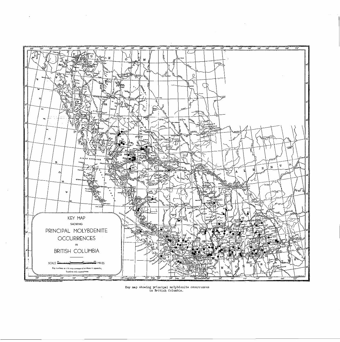
Key map showing principal molybdenite O C C w r e n O e S i n B r i t i s h Columbia.

CONTENTS.
Page
11 9
1 6 19 2 0
33 28
34
4.7 4.9 50 51 54 58 6 1
7 0 67
73
77
79

ILLUSTRATIONS.
Page
Key map showing pr incipal molybdeni te occur rences i n Br i t i sh Columbia ................................. Front i sp iece
Figure (1) - Anticlimax molybdenite property: pace, compass and barometer survey ..................................... i!3
Figure ( 2 ) - Consolidated Mining and Smelting Company molybdenite property, Boss Mountain. General plan of workings. Tape, compass survey ........................................ :. _ ..................................................... 37
Figure ( 3 ) - Consolidated Mining and Smelting Company molybdenite property, Boss Mountain. Detail of creek showings. Tape, compass survey ............................................................................................. 39
Figure ( 4 ) - Tidewater molybdenum property. Plan showing surface geology ..................................................................................... 61
Figure ( 5 ) - Tidewater molybdenum proper ty . P lan showing underground geology I63
Figure ( 6 ) - Tidewater molybdenum property. Assay p lan ................................................................................................................................................. ... I67
Figure ( 7 ) - Allies molybdeni te property: pace, com- pass and barometer survey ........................................................................... 76
P l a t e I, A - Mineralized boulder on S t e l l a molybden- i t e p r o p e r t y , showing typ ica l r i bbon-
t h i n l a y e r s o f molybdeni te in ve in quar tz . s t r u c t u r e of v e i n , r e s u l t i n g f r o m paper-
Boulder 3 f e e t long ...................................................... " ............................................ 12
P l a t e I, B - Twin peaks of Boss mountain .................................................................... 1 2
P l a t e 11, A - Camp of Consolidated Mining and Smelting Company on t h e i r Boss mountain molybden- i t e p r o p e r t y ; camp a t headwaters of Molybdenite Creek 12
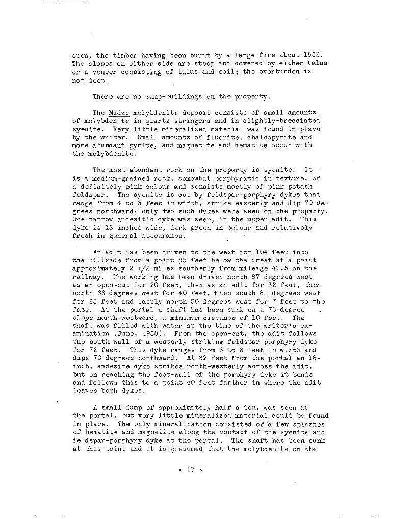
P l a t e 11, B - Specimen showing brecc ia ted na ture of minera l ized f rac ture-zone , Boss mountain molybdenite property of the Consol idated Mining and Smelting Company ................................................. . 1 2
PREFACE.
molybdenum d e p o s i t s v i s i t e d by the wr i t e r du r ing t he cour se of f i e l d work f r o m 1937 t o 1939, i nc lus ive . ITith t h e excep- t i o n of t he depos i t a t Al ice Arm, a l l t h e more important de- p o s i t s and many, though not a l l , of the l ess impor tan t depos i t s i n t h e P r o v i n c e w e r e v i s i t e d by t h e w r i t e r . J . T. Mandy of t h e Department of Mines examined the A l i ce Arm d e p o s i t i n 1939, and a synopsis of h i s r e p o r t i s i n c l u d e d i n t h i s b u l l e t i n .
The p resen t bu l l e t in i nc ludes geo log ica l desc r ip t ions of
To make t h e b u l l e t i n more comprehensive, an introductory chapter i s inc luded t ha t b r i e f ly desc r ibes t he mine ra logy , geological occurrence, metallurgy and economics of molybdenum
An appendix has been added t o t h e b u l l e t i n i n which brief notes are given concerning a l l t h e known occurrences of molyb- d e n i t e i n B r i t i s h Columbia t h a t have come t o t h e a t t e n t i o n of t h e Mines Department. This appendix includes (1) occurrences f u l l y d e s c r i b e d i n t h i s b u l l e t i n , marked w i t h a n a s t e r i s k , and ( 2 ) occurren'ces described elsewhere as ind ica t ed by the key of r e fe rences arid concerning many of which only incomplete in- formation i s a v a i l a b l e .
The w r i t e r w i s h e s t o acknowledge t h e k i n d a s s i s t a n c e and cooperation rendered by mine o f f i c i a l s and prospec tors assoc i - a t e d w i t h t h e p r o p e r t i e s v i s i t e d . Alan R. Smi th , the wr i te r ' s
g r e a t l y f a c i l i t a t e d t h e f i e l d ' w o r k by h i s capab le and hea r ty s t u d e n t a s s i s t a n t d u r i n g t h e f i e l d s e a s o n s of 1938 and 1939,
cooperat ion.

INTRODUCTION.
Molybdenum Minerals
d e n i t e (MoS2) i s of commercial importance. The p rope r t i e s of There are many molybdenum minerals, but only one, molyb-
molybdenite and o f t he more common molybdenum mine ra l s a r e l i s t e d below.
Molybdenite - Composition - Molybdenum sulphide, IwoS;! = molybdenum, 60.0 per cen t , su lphur , 40:O per cen t .
Lus t r e me ta l l i c . Colour lead gray , b lu ish g ray s t reak as com- pared wi th the carbon-b lack s t reak of graphi te . Opaque. Hard- ness, 1 t o 1.5, S e c t i l e . Laminae f l e x i b l e b u t n o t e l a s t i c . Commonly f o l i a t e d , i n r o s e t t e s of c r y s t a l s of f i ne g ranu la r .
Molybdite - Composition - molybdenum t r i o x i d e , MoO3. Colour straw-yellow. Molybdite i s often confused with molybdic ocher. Common oxidat ion product of molybdenite.
Molybdic ocher - Composition - hydrous fe r r ic molybdate . Colour yellow. Often mistakenly called molybdite. Common oxi- dat ion product of molybdenite.
Wulfehite - Composition - lead molybdate, PbMoOq = molybdenum tr ioxide 39.3 per cent , lead oxide, 60.7 per cen t . Lus t re res inous - colour var ies , g rey , brown, orange-yellow, olive- green, orange to b r igh t r ed . S t r eak wh i t e . Sub t r anspa ren t . Hardness 2-3. Fracture subconchoidal. Occurs as tabular crys- t a l s or granular and massive.
Powel l i te - Calciumjmolybdate, chillagite, lead molybdate with lead tungstate, and koechlinite, bismuth molybdate, are rare.
- 1 -

Geological Occurrence
The fo l lowing no tes concern ing the geologica l occur rence of molybden i t e a r e g iven t o a s s i s t i n eva lua t ing t ypes of molybdeni te depos i t s tha t may be found during the course o f prospect ing for t h i s m i n e r a l .
ra ther acid igneous rocks such as g ran i t e , g ranod io r i t e and quar tz -d ior i te . Depos i t s assoc ia ted with d i o r i t e and more
w!!thin the body of the igneous rock i t s e l f , or c l o s e t o it. bas i c t ypes a r e r a r e . 1n .mos t i n s t ances t he depos i t occu r s
Most m o l y b d e n i t e d e p o s i t s a r e g e n e t i c a l l y r e l a t e d t o
No lybden i t e depos i t s i nc lude t he fo l lowing t ypes , l i s t ed in o rder of impor tance : (1) s i l i c i f ied f rac ture-zones : ( 2 ) quar t z ve ins ; (3 ) .pegmat i t e s and a p l i t e s : ( 4 ) high-temper- a ture rep lacement depos i t s : ( 5 j cer ta in disseminated chalcopy- r i t e d e p o s i t s .
rock , the f ragments of which have been sealed by vein-quartz and molybdenite. The molybdenite may occur a s coarse p l a t e s
v e i n l e t s . The form of ore-body i s commonly t h a t of a ' p i p e o r a l o n g t h e f r a c t u r e s , o r as v e r y f i n e g r a i n s w i t h i n t h e q u a r t z
This type of depos i t usua l ly possesses a g r e a t e r c o n t i n u i t y of s tock w i th t he ve r t i ca l d imens ion g rea t e r t han t he ho r i zon ta l .
mine ra l i za t ion and r e su l t an t l a rge r t onnage of ore t han t he o ther types of molybdeni te deposi ts .
S i l i c i f i e d f r a c t u r e - z o n e s are charac te r ized by brecc ia ted .
amount of molybdenite obtained from such deposits is not l a rge . The ve ins range in wid th from a f r a c t i o n of an i nch t o s eve ra l f e e t , and f rom short lenses a few f e e t l o n g t o ve ins s eve ra l hundred f e e t in l eng th . However, no t on ly a r e t he ve ins o f t en
mine ra l i za t ion t ends t o be spo t ty i n i t s d i s t r i b u t i o n w i t h i n l e n t i c u l a r and d iscont inuous in l ength , bu t the molybdeni te
t h e v e i n . For t hese r easons it i s always wise t o do a consider-
mitments concerning possible tonnages. a b l e amount of development on such a depos i t before making com-
Molybdeni te-bear ing quartz veins are widespread, but the
The mineralogy or" quartz-molybdenite veins i s simple, con- s i s t i n g u s u a l l y of quartz , molybdeni te and pyri te , and occasion- a l ly cha lcopyr i t e , spha le r i t e and ga l ena .
Molybdeni te-bear ing pegmati te and apl i te dykes are common, p a r t i c u l a r l y i n e a s t e r n Canada. The f o r m o r a pegmatite dyke i s a p t t o be dec ided ly l en t i cu la r , ap l i t e s no t so much so. The amount of molybdenite obtained from pegmatites and apli tes
i s not l a rge , and, with a few exceptions, most occurrences are of more s c i e n t i f i c t h a n economic importance.
Two types of high temperature replacement deposi ts cc-. .
c a s i o n a l l y c o n t a i n a l i t t l e molybdenite. One type comprises
denum sulphides tha t have formed by replacement of l imestone. bodies of l ime-s i l ica te and assoc ia ted copper , i ron and molyb-
Because of t h e common l e n t i c u l a r n a t u r e of l imestone replaoe- ment bodies and of t h e complex me ta l lu rgy necessa ry t o ex t r ac t the molybdeni te f rom the int imately intergrown sulphides , t h a t character ise this type of high temperature replacement deposi t , t h e s e d e p o s i t s a r e u s u a l l y n o t of economic importance. The second t y p e of high temperature replacement body i s tha t where
f e l d s p a r , p y r r h o t i t e and molybdenite; they a re p robably c lose- schists have been replaced by bodies t h a t c o n s i s t of qua r t z ,
ly re la ted gene t ica l ly to rep lacement -pegmat i tes . These re- placement bodies tend t o be l en t i cu la r and sparsely mineral.- ized by molybdenite. Most of t h e s e d e p o s i t s a r e a g a i n of more s c i e n t i f i c t h a n economic importance,
A t ype of deposit which i s n o t r e p r e s e n t e d i n B r i t i s h
the south-western United States and Mexico, i s t h a t which con- Columbia and only, so f a r a s i s known t o t h e w r i t e r , found i n
s i s t s l a r g e l y of cha lcopyr i te and/or cha lcoc i te d i sseminated through la rge bodies of g ran i t i c rocks , which contain a small amount of molybdenite per ton. These deposits comprise large- s c a l e copper mining operations and the molybdenite i s recovered a s a by-product molybdenite concentrate from copper ores. Be- cause of the l a rge tonnage of copper o re t r ea t ed , t he amount of by-product molybdenite i s l a rge . Such depos i t s inc lude t h o s e a t Bingham, Utah; Chino, New Mexico; Miami, Arizona and Cananea, Mexico.
Metallurgy
not economica l ly p rac t ica l t o hand-short mine-run ore t o a Molybdenite ores always require concentration. I t i s
grade acceptable by f e r r o - m e t a l l u r g i c a l p l a n t s , t h e u l t i m a t e purchasers of molybdenite. Inasmuch a s t h e r e a r e v e r y few custom mills f o r molybdenite ores, and none i n B r i t i s h Colum- b i a , it i s necessary tha t any owner o r prospec t ive purchasw of a molybdeni te property bear in mind t h e . p r o b a b l e n e c e s s i t y of do ing h i s own concent ra t ing .
t o g r a v i t y c o n c e n t r a t i o n and f l o t a t i o n i s used exc lus ive ly i n Because of i t s f l a k y nature, molybdenite i s not amenable
i t s recovery. In a good m i l l a recovery of 80 t o 90 per cent . i s customary. A f lo ta t ion concent ra te ranging f rom 80 t o !30 per cent. molybdenite (MoSz) i s u s u a l l y made and shipped a:$
- 3 -

such t o m e t a l l u r g i c a l p l a n t s .
The o r d i n a r y f l o t a t i o n m i l l - c i r c u i t i s used. This employs the usua l j aw-crushers , ba l l -mi l l s , c lass i f ie rs , rougher ,
pans. I n a few depos i t s the molybdeni te i s i n l a r g e c r y s t a l s s c a v e n g e r a n d c l e a n e r c e l l s , t h i c k e n e r s , f i l t e r s and drying
and it is n o t n e c e s s a r y t o g r i n d v e r y f i n e l y , b u t i n most de- pos i t s the molybdeni te i s very f ine-grained and it is neces- sary t o g r i n d t o minus 200 mesh. Because it is e s s e n t i a l t o keep t he copper content of t he concen t r a t e down t o Copper (Cu)
d e n i t e and chalcopyrite. The dr ied molybdeni te concentrate i s 0.2 per cent . , a good separation must be made between molyb-
packed in e i t h e r heavy j u t e s a c k s o r oak b a r r e l s f o r shipment t o m e t a l l u r g i c a l p l a n t s f o r p rocess ing i n to molybdenum car - bide, ferro-molybdenite, calcium molybdate, o r into whatever form of molybdenum t h e s m e l t e r s r e q u i r e f o r a d d i t i o n i n t o t h e s t e e l o r s t e e l - a l l o y f u r n a c e s .
Economics - of Molybdenum
- Uses:-- Most of t h e molybdenum.produced i s used i n t h e i r o n and s t e e l i n d u s t r y , and l e s s e r amounts i n the chemical and e l e c t r i c a l i n d u s t r i e s .
of molybdenite ( M o S ~ ) , b u t for i ndus t ry t h i s i s conver ted in to one of the following forms: (a) ferro-molybdenum containing 60 t o 65 per cen t . molybdenum, or (b) ca lc ium tungs ta te conta in- ing 35 t o 45 per cen t . molybdenum, o r ( e ) l e s s f r e q u e n t l y molyb- denum oxide b r ique ts , o r (d ) t he pu re me ta l .
The concentrate received f rom the mines i s a concent ra te
t he s t ee l bo th i n t he open-hea r th o r e l e c t r i c f u r n a c e as e i - t h e r ferro-molybdenum or calcium molybdate, al though in 1939 experiments in adding molybdenum s u l p h i d e a r e r e p o r t e d t o have
w i t h t h e molybdenum compound. I n processes recent ly developed met w i t h some success . Other a l loy ing meta ls a re usua l ly used
i n t h e making of h igh - speed t oo l s t ee l s , molybdenum i s being s u b s t i t u t e d for tungsten as. the a l loy ing meta l of importance.
I n t h e i r o n a n d s t e e l i n d u s t r y , molybdenum is added t o
Molybdenum s t e e l s a r e r e p o r t e d t o p o s s e s s t h e f o l l o w i n g d e s i r a b l e q u a l i t i e s : g r e a t e r h a r d n e s s a n d s t r e n g t h a t h i g h
r e s i s t a n c e t o c reep and e longat ion a t high temperatures . temperatures, freedom from s c a l i n g and ease of forging, and
In a d d i t i o n t o molybdenum s t e e l s , t h e r e a r e many spec ia l a l l o y s of molybdenum wi th coba l t , chromium and n i c k e l that con- sume a fa i r amount of molybdenum. The most recent development i n t h e u s e of molybdenum-alloys consists i n p l a t i n g molybdenum-
- 4 -

nickel over cadmium t o g i v e a molybdenum-black e l e c t r o p l a t i n g f i n i s h .
. I t i s used a s a r e a g e n t i n making ce r t a in ana ly t i ca l de t e rmin - Molybdenum f inds s eve ra l u ses i n t he chemica l i ndus t ry .
a t i o n s , as sodium molybdate i n t h e i n k a i d d y e i n d u s t r y , an.d as lead molybdate in the product ion of glass enamels.
pure metal in the form of t h in w i re s , r i bbons o r p l a t e s f o r incandesoent lamps, radio tubes, heating elements i n f i rnaces , i n X-ray tubes and a s e l ec t r i ca l con tac t po in t s . .
In t h e e l e c t r i c a l i n d u s t r y , molybdenum is used as the
t e r e d powdered metal industry. A growing use f o r t h e m e t a l i s being developed i n t h e s i n -
most concentrates are purchased on a con t r ac t bas i s , r equ i r e - Spec i f i ca t ions of product , pr ices and t a r i f f s : - - Inasmuch E.S
ments concerning the grade of the concent ra te and the maxin~um amount of impur i t i e s pe rmis s ib l e va ry acco rd icg t o t he uses: t o which the purchaser i s go ing t o pu t t he concen t r a t e s .
The product i s marketed as a concentrate ranging f rom 80
most undesirable impurity, and.most purchasers w i l l not accept t o 90 per cent. contained molybdenite (MoS2). Copper i s t h e
concentrates containing over 0.2 per cent. Copper (Cu). I r o n
per cent. each. should not exceed 10 per cent . ; b ismuth and t i n not over 0 . 5
a s 45 cents per lb . of contained molybdenite (MoSz), f .o .b . , The p r i c e lor molybdenite i s quoted nominally a t New Jlork
mines, on a 90 per cent. concentrate, and, l ikewise nominally, a t London a t 48 sh i l l i ngs pe r l ong t on un i t of 22.4 lbs . for an 85 t o 90 per cen t . concent ra te ( E . and M.J. Metal and Miin- era1 Markets - Feb. 29, 1940). An i m p o r t t a r i f f i n t o t h e United States places a duty of 35 cents per pound of contaihed m e t a l l i c molybdenum, or 2 1 cents per 'pound of molybdenite (MoSz) i n o r e or concent ra tes .
The main desideratum of a purchaser of molybdenite i s an adequate present supply of a uniformly high-grade product. In- asmuch a s t h e m a t e r i a l i s used a s an a l loy ing me ta l i n a s t e e l bath, smal l deviat ions f rom the grade of the p roduct and small
a b l y t h e p h y s i c a l c h a r a c t e r i s t i c s of t h e r e s u l t i n g s t e e l a l l o y . i nc reases i n undes i r ab le impur i t i e s w i l l a l t e r v e r y c o n s i d e r -
ab le o re , t he g rades of o r e a t two important operat ing molyb- Grades of mineable ore:-- As a g u i d e t o w h a t c o n s t i t u t e s mine-
deni te mines a re g iven . A t Climax, Colorado, 12,000 tons (of
- 5 -
o r e d a i l y a r e b e i n g mined from a la rge , un i formly minera l ized
molybdenite, (NoS2). A t Ques ta , New Mexico, a much smaller body of sheared gran i t ic rock; the o re averages 0.606 per cent .
the Questa ore ranges f rom 3 t o 15 per cent. molybdenite (MoS2) tonnage of o r e is being mined from several narrow quartz veins;
kept a t o r above 6 per cent. molybdenite (MoS2). as mined, but by hand s o r t i n g and sc reen ing t he m i l l f eed is
These two examples, Climax and Questa, show t h a t ( 1 ) i n a deposit where the molybdenite i s un i fo rmly d i s t r ibu ted
much g r e a t e r and much more ce r t a in and , t he re fo re , t he pe rmis - through an area or zone of sheared rock, the tonnage of ore i s
s i b l e g r a d e of o r e much l o w e r t h a n i n t h e q u a r t z - v e i n t y p e of molybdeni te deposi t , and t h a t ( 2 ) i n a quar tz -ve in type of de-
and , therefore , the permiss ib le g rade of o r e much h igher than posi t the proven, as wel l as the probable ore , i s much l e s s
i n t y p e ( 1 ) . I n c o n s i d e r i n g a property of t ype (l), t h e o r e wid ths should no t be l ess than a mining width, of say 3 f e e t , t he i nd ica t ed l eng th shou ld be 200 f e e t o r more and t h e a s s a y g rade no t l e s s t han 1 per cent . molybdeni te (MoS2). In con- s i d e r i n g a proper ty of type ( 2 ) , the quar tz -ve in type , o re widths should be a t l e a s t 1 foot or if t he ve ins a re smal le r , they should be c lose enough togeth.er t o permit mining both the ve ins and i n t e r v e n i n g w a l l r o c k a l l t o g e t h e r ; t h e i n d i c a t e d length of t h e o r e zone should be. 200 f e e t or more and t h e as- say across ind iv idua l ve ins of a f o o t o r more i n w i d t h n o t l e s s than say 10 per cent. molybdenite (MoS7,).
Product ion:--The greatest par t of t he wor ld ' s p roduc t ion o f molybdenite comes from the United States, and most of t h e r e - mainder from Mexico and Norway.
The Climax, Colorado mine o f t h e Climax Molybdenum Com- pany produced 78 per cent . of t h e world output, and 85 per cent . of t he Un i t ed S t a t e s ou tpu t i n 1938. The only o ther i m - por tant molybdeni te mine i n t h e U n i t e d S t a t e s i s t h a t of t h e Molybdenite Corporation of America near Questa, New Mexico. However, a considerable tonnage of molybdenite i s produced a s a by-product from several o f t he l a rge coppe r mines i n t h e
of the Utah 'Copper Ccmpany; the Chino, New Mexico, proper ty south-west ; these i n c l u d e t h e Bingham Canyon, Utah, property
of t h e Nevad.a Consolidated Copper Corporation; and the Miami, Arizona, property of t h e Miami Copper Company. Durj.ng 1939, by-product molybdenite accounted for one-fourth of the Uni ted States product ion.
The Mexican output of molybdenite i s a by-product concen-
- 6 -
.

t r a t e i n t h e t r e a t m e n t of copper ores from the Cananea, Mexico, copper property of t h e Greene Cananea Copper Company; t h i s m b e produced 483 m e t r i c t o n s of molybdenum i n 193%.
The Norwegian production comes from a molybdenite mine a t Knaben; t h i s mine produced 450 me t r i c t ons of molybdenum i n 193%.
Chile, South America, entered into the world’s production p i c t u r e i n 1939 when t h e Braden copper mine a t Sewell, Chile, began the p roduct ion of by-product molybdenite.
Although the wor ld’s l ead ing producer of molybdenite dur-
the p roduct ion of molybdenite today f r o m Canada i s small . The i n g t h e l a s t G r e a t Nar was t h e Moss mine, a t Quyon, Quebec,
t he on ly ope ra t ion i n 1938, produced 7 me t r i c t ons of concen- Zenith Molybdenite Company, Renfrew County, Ontario, apparently
‘crates. However, development work and m e t a l l u r g i c a l t e s t i r g of o re a r e be ing ca r r i ed on a t a number of proper t ies in Quebec , Ontar io and B r i t i s h Columbia.
- 7 -

Xorld Production of
Molybdenum Ores and Concentrates, 1934-38, i n Me t r i c Tons
(Compiled by M.T. Latus, U.8. Bur. Mines, 1939, p . 619. j
Country
Aus t r a l i a : New South Xales ( concen t r a t e s ) Queensland (concentrates) V ic to r i a ( concen t r a t e s )
Burma Canada ( concen t r a t e s ) China (ore conta in ing 45% Mo) Chosen ( o r e ) I t a l y ( o r e ) Japan (dressed ore) Mexico (Mo con ten t ) Morocco, French (concentrates) (3) AorNay (ti0 conteEt) Peru (concent ra tes ) Rumania (Bi-Mo o r e )
Uni ted S ta tes (Mo content ) Turkey ( o r e )
Yugoslavia -
(1) Le'ss than 1 ton . ( 2 ) Data no t ava i l ab le . (3 ) Exports.
1934 I . 1935 I
" "
2 ( 2 ) 104 106 " "
5 467
6 687
149 190 146 388
13 14
4247 5222 18
15 6
" "
"
I
1936
(1) 2 0 -_ "
"
( 2 )
861 80
534 7
187 422
1 9 46
7795 "
"
1937 1938

product ion of molybdenite comes f r o m the Cord i l l . e r a , t he moun- t a in r anges t ha t compr i se t he wes t e rn pa r t of North America. Even except ing the Climax, Colorado deposit, which i s respon- s i b l e f o r 85 per cent . of the Uni ted S ta tes p roduct ion , by f a r t h e g r e a t e r p a r t of the remainder comes f r o m a sec t ion of t h e Cord i l l e r a t ha t ex t ends from Mexico t o Utah. The no r the r ly
t i s h Columbia i s n o t e s s e n t i a l l y u n l i k e t h a t of the United extension of t h e Cord i l l e r a from the Uni ted S t a t e s i n t o Bri-
S ta t e s , and i n view of the success tha t has a t tended the de- velopment of molybdeni te prospects in the United States , pros- pec t ing L'or molybdenite and the development of molybdenite p r o s p e c t s i n t h e B r i t i s h Columbia s e c t i o n of t he Cord i l l e r a . should be encouraged.
I t i s t o be no ted t ha t t he g rea t e r pa r t of t h e w o r l d ' s
MARTEL ( l)# Building, Vancouver, owns a gold-molybdenite The Martel Gold Mines, Limited o f 715 Hall
proper ty commonly known as the Mar t e l . Thi.s property includes the mineral c la ims Hat Nos. 1 t o 11 inolus- ive , s taked in 1933, the Bug Nos. 1 2 t o 14 , i nc lus ive , s t aked i n 1933, t h e Axe, s t a k e d i n 1932, the.BoFand Boe No. 1, s t a k e d i n 1933 and t h e Dave, Matt and Vernon staked in 1933. The w r i t e r , accompanied by J. M . Cummings of this Department, examined t h e showings in July, 1937.
- - " -
The proper ty i s i n Venables Valley, 13 miles north of Spence's Bridge and approximately 5 miles north-west of Martel ,
claims leaves the Cariboo Highway a t a point 13 miles north of a s t a t i o n on the Canadian National Railway. k r o a d t o t h e
Venables Val ley, thence a long the val ley south-easter ly fol- Spence's Bridge and goes south-westerly f o r 2 1/2 m i l e s t o
approximately half a mile t o the p roper ty on the south-west
road l ead ing t o t he mine, and the workings are 180 f e e t above s i d e o f t h e v a l l e y . The camp i s a t t h e end or' a short branch-
t h e , camp.
covered by an open-growth of l i gh t t imber ; t he unde rb rush .is n o t heavy; The overburden i s comparatively shallow and rot-.k exposures ar,d b l u f f s a r e common, par t icu lar ly above the wo:rk- ings.
The h i l l s i d e i n t h e v i c i n i t y of the workings i s s t e e p and
quar tz ve ins in a rg i l laceous sed iments and in te rca la ted vo i - The d e p o s i t c o n s i s t s of a group of small., l e n t i c u l a r
f' This number appears on t h e k e y map ( f ront i sp iece) where it indica tes the approximate pos i t ion of t h e p r o p e r t y .
- 9 -

canics . The veins range in thickness from a knife-edge t o 1 2 inches, and from sect ions 2 f e e t l o n g t o 60 f e e t i n length. The m i n e r a l i z a t i o n c o n s i s t s o f . q u a r t z and small amounts of molybdenite. Where heavies t , the molybdeni te occurs in paper - t h i n r i b b o n s t h a t p a r a l l e l t h e w a l l s o f t h e v e i n . In a l l , bgenty-six samples were taken f rom t h e .veins, adjoining w a l l rock and faul ts underground; one sample contained: Molybden- i t e , 0 . 2 p e r c e n t . ; a l l the other samples assayed t races and
and - n i l s , w i t h t he excep t ion of one which assayed: Silver, 0 . 2 ounces per ton.
- n i l s . Samples assayed fo r go ld and s i l v e r a l s o r a n t r a c e s
follows: from t h e p o r t a l , s o u t h 10 degrees wes t for 376 f e e t ,
west fo r 134 f e e t t o t h e f a c e . A t 164 f e e t from t h e p o r t a l a then south 60 degrees wes t fo r 24 f e e t , t h e n n o r t h 70 degrees
short working extends north 75 degrees ea s t f o r 24 f e e t . A t 178 f e e t f rom the portal , a working, known a s t h e E a s t Drift, extends south 55 degrees east f o r 1 1 2 f e e t , t h e n s o u t h 20 de- g r e e s e a s t f o r 2 2 f ee t , t hen sou th 30 deg rees wes t f o r 16 f e e t , then south 50 degrees west for 48 f e e t t o t h e f a c e . From t h e same poin t , 178 f e e t f rom the portal , a short working extends no r th 55 degrees west f o r 24 f e e t t o t h e c o l l a r o f a winze', which i s s u l k on a 60-degree s lope south 10 degrees west for 88 fee t . This winze will be referred t o as the 60-degree,winze. A t a po in t 48 f e e t f rom the col lar of the winze , a working ex- tends south 75 degrees ea s t for 48 f e e t t o t h e f a c e . A t 2 0 feet f rom the winze a s h o r t d r i f t e x t e n d s s o u t h 10 degrees west fo r 1 2 f e e t a1or.g a 10-inch wide quartz vein. A t 188 f e e t from t h e p o r t a l of t h e a d i t , a working extends south 75 degrees west f o r 2 0 f e e t . From t h e end of th i s working a winze i s sunk south
w i l l be r e f e r r e d t o a s t h e 30-degr.ee winze. Ten f e e t up from 75 degrees west for 55 f e e t on a 30-degree slope. This winze
the bot tom of t h e w i n z e a working extends north 20 degrees west for 3 2 f e e t .
The main working is a n a d i t , 1032 f ee t l ong , d r iven a s
Between points 164 and 178 feet f rom the portal , the adi t fol lows two 6 - i n c h q u a r t z v e i n s t h a t s t r i k e n o r t h 40 degrees
d i e o u t i n t h e w a l l , and to the south-wes t , cont inua t ion of t h e e a s t and d i p 70 degrees north-westward. To t he no r th -eas t t hey
ve ins i s d i sp laced 15 f ee t sou th -eas t e r ly by a s t r o n g f a u l t . The "East Drift" f o l l o w s t h i s f a u l t , s t r i k e n o r t h 48 degrees wes t , d ip 60 degrees south-westward, for 105 feet south-eas- t e r l y and f o r 24 fee t nor th-wes ter ly ; the 60-degree winze fo l - lows down t h e d i p o f t h e f a u l t a t t h i s p o i n t . Between 178 f e e t and 188 f e e t f r o m t h e p o r t a l t h e main a d i t f o l l o w s t h e ve ins , and then, a t 188 feet , the branch working and 30-degree winze fo l low the ve ins for a combined d i s t a n c e of 72 f e e t . Close t o t h e e n t r a n c e of the 30-degree winze the veins have
- 10 -

been cut by a v e r t i c a l f a u l t t h a t s t r i k e s n o r t h 8 0 d e g r e e s wes t and d i sp laces the ve ins 6 inches. Down t h i s winze, the ve ins t ha t r ange from 1/2 an inch to 6 inches wide, are de- c i d e d l y l e n t i c u l a r and discont inuous and tend t o f e a t h e r o u t i n t o s t r i n g e r s .
A t a point 48 f e e t from t h e c o l l a r of the winze, a d r i f t
t h e s i d e of t h e winze, on t h e nor th-eas t o r . foo twal l - s ide of i s dr iven a long t h e v e r t i c a l f a u l t , and a t a po in t 4 f e e t from
t h e f a u l t , t h , i s d r i f t i n t e r s e c t s t h e downward cont inua t ion of one of the ve ins from t h e l e v e l above and, 10 f e e t f a r t h e r a long , t he f au l t ed con t inua t ion of t h i s v e i n and o the r l enses in the hanging-wall . These veins range f rom 4 t o 1 2 inches in wid th .
Two, and .in p l a c e s t h r e e , s t r i n g e r s of unmineralized quartz ranging f rom 1/2 an i n c h t o 2 inches ' in thickness , ex- t end sou th -eas t e r ly fo r 108 f e e t back from t h e f a c e of t h e main a d i t .
A t a point 256 f ee t sou th -eas t e r ly a round t he h i l l s ide rrom the ad i t and approximate ly a t t h e same e leva t ion , an open-cut has been driven south 40 degrees west f o r 1 2 f e e t ac ross s ed imen t s t ha t s t r i ke no r th 40 degrees west and d i p 50 degrees south-westward.
F i f t y f e e t s o u t h - e a s t f r o m t h i s c u t a second one has been dr iven south 40 degrees west f o r 7 f e e t i n sediments o f a s i m i l a r a t t i t u d e .
Small a r e a s of q u a r t z - d i o r i t e t h a t may c o n s t i t u t e a dyke, outcrop south-west and nor th-eas t of t h e open c u t .
No mine ra l i za t ion was seen i n e i ther of t h e above c u t s .
STELLA ( 9 ) t o No. 4 mineral claims, staked i n 1927 by The S te l l a g roup cons i s t s of t h e S t e l l a N O a j a
- soc ia t e s , a l l of Fraser Lake. The w r i t e r examined the p roper - t y i n J u l y , 1938.
Chas. H. Foote, and owned by Foote and as-
t h e Canadian National Xailway and highway, approximately 120 The proper ty i s south of Endako, a small se t t lement 011
miles west of Prince George. It. may be reached f r o m Zndako by following a motor-road, that branches from the main Endako- Pr ince George highway ' a t a po in t 3 .5 mi l e s ea s t e r ly from X n - dako, for 3 mi l e s sou the r ly , and thence a long a logging-truck road wes t e r ly fo r 2 m i l e s t o a group o f deser ted camp-build.- ings a t an e l eva t ion of 2955 f e e t ; t h e n c e a t r a i l l e a d s s o u t h -
- 11 -

wes te r ly f o r 6700 f e e t t o t h e camp-cabin a t an e leva t i .on of 3380 f e e t .
The workings consis t of one ' ad i t , an i nc l ined sha f t and seve ra l su r f ace cu t s , some of which never reached bed-rock. All t he work ings t ha t r each bed-rock a r e e i t h e r on t h e ' t o p of or o n . t h e s o u t h e r l y s l o p e of a low, round-topped, .open-timbered r i d g e , t h e c r e s t of which begins a qua r t e r of a mile south- e a s t e r l y from t h e camp-cabin and extends for t h ree -qua r t e r s of a m i l e i n a d i r e c t i o n s o u t h 75 degrees west . . The r i d g e r i s e s t o a l-ieight of approximately ZOO f e e t above the sur rounding lowland. The workings tha t do not reach bed- rock a re on the c r e s t and sou the r ly s lopes of t h e n o r t h of t h e two k n o l l s t h a t c o n s t i t u t e t h e w e s t e r l y end of t h e r idge . Th i s no r th kno l l i s separated f rom the one to t he south by a swamp approximately 250 f e e t w i d e ; t h e c r e s t of t h e knoll i s 75 f e e t above t h e swamp.
The showings consist of sca t te red d i scont inuous quer tz - molybdeni te ve ins in p ink gran i te .
The veins range in s t r ' ike f rom nor th 70 d e g r e e s e a s t t o
southward. They range in wid th f rom 2 t o 32 inches and i n south 80 degrees ea s t , and i n d i p , from v e r t i c a l t o 80 degrees
b e s t showing i n t h e s h a f t w h i c h h a s a n i n d i c a t e d l e n g t h o f 75 length from a few f e e t t o 8 f e e t , w i t h the except ion of t h e
f e e t . Most commonly, the ve ins possess a r ibbon t ex tu re , caused by closely spaced films of very f ine-gra ined molybden- i t e t h a t p a r a l l e l t h e w a l l s of t h e v e i n ( P l a t e I A ) .
f ine-grained molybdeni te and occasional ly a l i t t l e p y r i t e i n ve in qua r t z .
The mineralogy o f t h e v e i n s i s s imple , cons is t ing of
The preva i l ing rock i s a medium-grained pink granite, t h a t i n a few places i s c u t by l enses of a p l i t e .
a r idge tha t ex tends south-wes ter ly from t h e camp-cabin f o r approximately three-quarters of a mi l e .
The main showings l i e on t h e t o p and sou the r ly s lope of
A t an e i eva t ion of 3430 f e e t a n a d i t h a s been driven n o r t h - w e s t e r l y i n t o t h e h i l l s i d e f o r 35 f e e t from a point 3600 f e e t i n a d i r e c t i o n s o u t h 55 degrees west from the camp-cabin; the adi t i s t imbered nea r ly t o t he f ace and could not be examined. The rock cons i s t s of p i n k g r a n i t e t h a t a t t h e f a c e i s cu t by numerous c l o s e l y - s p a c e d f r a c t u r e s , s t r i k e
t h e face, t h e rock i n t h e a d i t - f l o o r i s i r r e g u l a r l y f r a c t u r e d e a s t and d i p 65 degrees south. A t a p lace 5 f e e t back f r o m
- 1 2 -

PLATE I.
A. Mineralized boulder on Stella molybdenite property, showing typical ribbon-structure of vein,
resulting from paper-thin layers of molybdenite in vein quartz.
Boulder 3 feet long.
B. Twin peaks of Boss mountain.
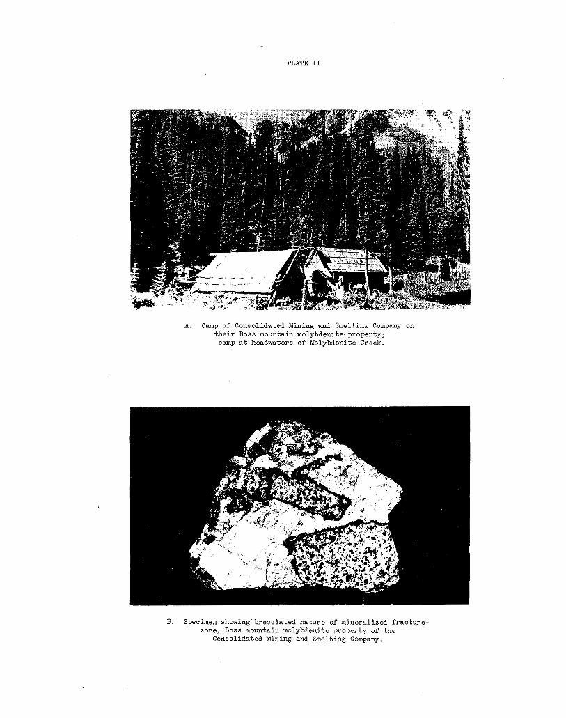
PLATE 11.
A. Camp of Consolidated Mining and Smelting Company on their Boss mountain molybdenite property;
a m p at headwaters of Molybdenite Creek.
B. Specimen showing'breociated nature of mineralized fracture- zone, Boss mountain molybdenite property of the
Consolidated Mining and Smelting Company.

and conta ins a small amount of molybdenite.
115 f e e t i n a d i r e c t i o n n o r t h 64 degrees west from t he po r t a l of t he ad i t . Th i s cu t has been d r iven f o r 15 f e e t i n a d i r e c - t i o n n o r t h 8 d e g r e e s e a s t t o a lO-J'oot face which has l a rge ly
5 f e e t i n d i a m e t e r by 1 foot in depth, assayed: Molybdenite, sloughed. 9 sample of average mater ia l t aken from a n o r e p i l e
0.8 per cent. This broken vein-matter consists of t h i n films or ribbons of molybdeni te in quar tz .
No. 1 showing i s a c u t a t an e l e v a t i o n ' o f 3480 f e e t an.d
No. 2 showing i s a n i r r e g u l a r s t r i p p i n g a t an e leva t ion of 3480 f e e t a n d 3 0 f e e t i n a d i r e c t i o n n o r t h 65 degrees west from No. 1 showing. A t t h e e a s t end of t h e s t r i p p i n g , t h r e e 2- inch quar tz -molybdeni te ve in le5s s t r ike eas t and d i p 60 de@;rees
occasional vein-ividths of 6 inches. south. The dump, however, shows p ieces of o r e t h a t i n d i c a t e
No. 3 showing, a t r ench a t an e l eva t ion o f 3460 f e e t e.nd 210 f e e t i n a d i rec t ion south 85 degrees wes t f rom No. 2 show-
g r a n i t e in t h e f l o o r . ing, i s 20 f e e t l o n g i n a no r the r ly d i r ec t ion t ha t exposes on ly
No. 4 sho-fling, an i r r egu la r s t r i pp ing t ha t ex t ends 1 7 f e e t
v a t i o n of 3460 f e e t and 30 f e e t w e s t e r l y from No. 3 showing. i n a n e a s t e r l y d i r e c t i o n and 10 f e e t t o t h e n o r t h i s a t a n e l e -
mately 6 f e e t i n d iameter , tha t has been cu t by numerous The s t r ipp ing exposes an i r regular a rea of grani te approxi -
q u a r t z s t r i n g e r s and i s marked on t h e n o r t h s i d e by a s t rong
f o r 8 f e e t . The wes ter ly ex tens ion o f t h i s band i s obscured 16 - inch ve r t i ca l band of q u a r t z s t r i k i n g n o r t h 70 degrees ea s t
by overburden and t o t h e e a s t it i s terminated by a v e r t i c a l 3- inch shear-zone s t r iking north. A small amount of molyb-- d e n i t e o c c u r s i n t h e q u a r t z o f t h e showing. A sample taken across a 16-inch width of this quartz assayed: Molybdeni te ,
t h e a r e a assayed: Molybdenite, 0.6 per cen-t. From the south 0.85 per cent . A 6-foot sample t aken a long t he e a s t edge of
edge of t h e s t r i p p i n g , a t rench extends souther ly in overbur- den, and from the north side a t rench extends 14 f e e t n o r t h - e r l y i n g r a n i t e .
A t an e leva t ion of 3400 f e e t , No. 5 showing, an inc l ined
24 f e e t , on a s lope angle o f 53 degrees f rom a p o i n t . 3 2 0 f e e t shaft , has been sunk in a d i rec t ion south 15 degrees eas t .'or
a d i t . A t t h e t i m e of the wr i te r ' s examinat ion , ( Ju ly , 24, i n a d i r e c t i o n n o r t h 32 degrees wes t f rom the por ta l of No. 1
1938) t h e w a t e r l e v e l i n t h e i n c l i n e Gas 1 7 f e e t below t h e c o l l a r .
- 13 -

t h a t , above the water l eve l , ranges f rom 32 i n c h e s t o 24 inches The incline has been sunk on a l e n t i c u l a r v e i n of quartz
i n w i d t h on the wes t wall of the i nc l ine and f rom 2 i n c h e s t o 4 inches in width on t h e e a s t w a l l . A sample taken across 32 inches a t a po in t on t h e w e s t wall 5 f e e t from t h e c o l l a r as- sayed: Molybdenite, 1.6 per cent. The v e i n i s conspicuously f r a c t u r e d i n t o s l a b s r a n g i n g f r o m . 3 t o 6 inches i n width by
w a l l t h e ve in i s followed by a 2-foot zone of g r a n i t e t h a t i s f r a c t u r e s that p a r a l l e l t h e walls of t h e v e i n . In t h e hanging-
badly broken by c lose ly spaced , c r i ss -c ross ing jo in ts , and , a s a r e s u l t i s qui te f ragmenta l and badly oxidized; narrow i r - r e g u l a r s t r i n g e r s of quar tz and molybdenite traverse this zone. A 2-foot sample taken across this zone assayed; Molybdenite, 0.7 pe r cen t .
edge of t h e i n c l i n e . For 2 f e e t f r o m t h e edge of t h e s h a f t t h i s t r ench exposes a f r a c t u r e - z o n e t h a t c o n s i s t s of quar tz and molybdenite surrounding numerous granite inclusions; th i s zone s t r i k e s and d ips w i th t he main qua r t z ve in of t h e s h a f t . A sample of t h e m a t e r i a l i n t h i s zone assayed: Molybdenite, 1 .4 per cen t . For the remaining 15 f e e t of it 's l e n g t h , t h e t rench exposes badly f ractured, more or l e s s decomposed, g ran i t e t ha t con ta ins occas iona l qua r t z l enses from 1 i n c h ' t o 4 inches wide in which a small amount o f molybdenite occurs. One 10- and one 8-foot long sample, t aken a long t he wall of the t rench, assayed: Molybdeni te , 0.2 per cent. and 0.3 per cen t . r e spec t ive ly .
A t rench ex tends souther ly for 2 0 f e e t from the sou th
For a d i s t ance of t h ree -qua r t e r s of a mi l e no r th -eas t e r ly and to t he ea s t o f t he sha f t , s eve ra l t r enohes have been dug , but it i s r e p o r t e d t h a t none of these reached bed-rock.
No. 6 showing, a 20-foot t rench, a t an e l eva t ion of 3410 f e e t , i s 30 f e e t i n a d i r e c t i o n s o u t h 65 degrees west from t h e s h a f t . A t a p lace 5 f e e t from the south end of t he t r ench a 10-inch width of' vein-matter i s exposed t h a t i s probably a con- t i n u a t i o n of t h e s h a f t v e i n ; t h e f u l l width of t h i s v e i n was not exposed.
No. 7 showing, i s a t r ench 6 f e e t l o n g , a t a n e l e v a t i o n of 3420 f e e t , and 30 feet south 'wester ly from No. 5. The only e x p o s u r e i n t h i s t r e n c h i s a 2-foot width of quartz-molybdenite vein-matter t h a t a l so appea r s t o be a cont inua t ion of t h e ' s h a f t ve in . A s a n p l e t a k e n a c r o s s t h e f u l l 2 fee t assayed: Molyb- den i t e , 1.0 per cen t .
No. 8 showing, i s a s loughed t rench tha t i s 30 f ee t sou th - westerly from No. 6. No ro.ck i s exposed i n t h e t r e n c h b u t it
- 14 -

nearby, 3 f e e t by 2 f e e t b y 18 i n c h e s , s u g g e s t s t h a t t h e v e i n i s r e p o r t e d t h a t t h e v e i n was found and a l a rge p i ece o f rock
was 18 inches wide.
t ends wes te r ly f o r a t l e a s t 75 f e e t f rom the shaf t . Surface Exposures in the t r enches i n fe r t h a t t h e s h a f t - v e i n e:x-
work has f a i l ed t o f i n d any e a s t e r l y cont inuat ion.
molybdenite f loat which i s s c a t t e r e d on a low h i l l 900 f e e t nor th-wes ter ly f rom the shaf t across a swampy depression.
Several trenches have been dug i n t h e v i c i n i t y of qua:rtz-
The f i r s t of these t renches , descr ibed as No. 9, l i e s a t an e l eva t ion of 3375 f e e t and i s 8 7 0 f e e t i n a d i r e c t i o n n o r t h 88 degrees west f rom the shaf t . This t rench and others , one
tance of 400 f e e t n o r t h - e a s t e r l y u p t h e h i l l and on i t s sumit ly ing 75 f e e t w e s t e r l y from it, and the remainder wi th in a d i s -
( e l eva t ion 4310 f ee t ) , f a i l ed t o r each bed - rock , ht t h e d r i f t , and g l a c i a l till, t h a t t h e y c u t , c o n s i s t s of occasional sm,%ll boulders of quartz-molybdenite vein-matter.
A t a p o i n t t h a t i s approximately 700 f ee t sou th -eas t e , r ly from the camp-cabin, a cut has been dr iven f o r 1 2 f e e t i n a d i r e c t i o n n o r t h 30 degrees ea s t i n to t he sou the r ly s lope o f a kno l l on t h e n o r t h edge o f a small muskeg-area. This cut i s i n coarse-gra ined , p ink gran i te tha t conta ins a few i r r e g u l a r quartz veins which range in width f rom a kni fe edge to 6 i:nches.; the borders o f t h e s e v e i n s a r e n o t s h a r p and the ve in-mat te r conta ins smal l inc lus ions of t h e w a l l rock, but no molybdenite. Some i r r e g u l a r a r e a s of p ink ap l i t e were s een i n t he surro..md- ing g ran i t e .
e r l y s l o p e or' a h i l l t h a t l i e s o n e - q u a r t e r c r ' a m i l e s o u t h e r l y from t h e camp-oabin.
Several open-cuts have been dug on exposures on t h e s o u t h -
The f i r s t of these , descr ibed as showing No. 10, l i e s a t an e l eva t ion of 3320 f e e t on t h e s o u t h e r l y s l o p e o f t h e h i l l a t a point 1800 f e e t i n a d i r e c t i o n s o u t h . 8 d e g r e e s e a s t from t h e camp-cabin. This working,.a p i t 5 f e e t i n d i a m e t e r , a n d 2 f ee t deep , was caved a t t h e time of examination (July 24,
molybdenite vein-matter, and the ma te r i a l i nd ica t e s t ha t t : he 1938), bu t t he dump showed approximately 100 l b s . of quarte-
v e i n must have been a t l e a s t 6 inches wide. The rock formation i s p ink gran i te .
3370 f e e t and 350 f e e t i n a d i r e c t i o n no r th 70 degrees mes-t from No. 10. The on ly exposure i n t h i s t r ench i s p a r t of 2%
No. 11 showing i s a 1 0 - f o o t t r e n c h a t a n e l e v a t i o n of
- 15 -

f l a t - l y i n g p i e c e of v e i n - f l o a t a t the nor th-wes ter ly end of t he t r ench . However, t h e dump shows 150 l b s . of vein-matter
widths of a t l e a s t 6 i n c h e s a r e i n d i c a t e d by the dump-material, cons i s t ing of quartz, r ibboned by thin molybdenite seams; vein
e l eva t ion of 3330 f e e t and 1075 f e e t i n a d i r ec t ion sou th 65 degrees west from No. 11. it exposes patche's of a len-
width, on a p lane sur face or" p i n k g r a n i t e t h a t s t r i k e s e a s t and dips 30 degrees northward.
Xo. 1 2 showing i s a shallow p i t 4 f e e t i n d i a m e t e r , a t a n
t i c u l a r v e i n tha t ranges of an inch t o 4 inches i n
dimensions, at an e l eva t ion of 3310 f ee t , and 350 f ee t in a No. 13 i s a n i r r e g u l a r s t r i p p i n g 4 f e e t by 2 f e e t i n
d i r ec t ion sou th 67 degrees west from No, 1 2 . It exposes part
dips 50 degrees north-westward and i s 24 inches th ick . A of a quartz-molybden. i te lens that s t r ikes north 25 degrees ea s t ,
0.5 per cent . sample across the full 24-inch width assayed:' Molybdenite,
P rospec t ing t o da t e i nd ica t e s t he p re sence of a f a i r grade of molybdeni te mineral izat ion. The wr i t e r sugges t s t ha t t he sha f t -ve in be p rospec ted fu r the r .
This molybdenite property includes ' the
by P. 0. F r i s k e and owned by A. J. Cleeton 'of MIDAS (11) Nos. 1 t o 4 minera l c la ims s taked in May, 1938,
Cascade. This property was examined by t h e w r i t e r i n J u n e 1938.
The c l a i m s l i e i n t h e Trail Creek Mining Division t o t h e nor th-eas t of t h e f l a g - s t a t i o n Tunnel on t he Ke t t l e Va l l ey Branch of t h e Canadian Pacific Railway. Tunnel i s a t mileage 50, a s measured w e s t e r l y from Nelson. From Tunnel t h e p r o p e r - t y i s reached by leaving the ra i lway a t Mile - 47..5 and pro- ceed ing up t he r e l a t ive ly open h i l l s i d e and a long t he r i dge - t o p i n a sou th -wes te r ly d i r ec t ion f o r approximately 2 1/2 . miles. There i s no well-def ined t r a i l .
The showings a re ex t r eme ly o ld and t h e s u r f a c e work is d l caved. The main workings are two adits, a t approximately
t r end ing r i dge and approximate ly 80 fee t be low the c res t . 5000 f e e t e l e v a t i o n , on t h e e a s t e r l y s i d e of a nor the r ly
This r idge i s t h e t o p of a spur t h a t extends down t o t h e n o r t h between Brooklyn and ?up.Creeks. There i s also an open-cut and caved shaf t on t h e e a s t e r l y s i d e of t he r i dge on ly a few f e e t below t h e t o p a t a poin t approximate ly 1000 fee t to the south of t h e a d i t s .
The r i d g e - t o p i n t h e v i c i n i t y of the workings i s q u i t e
- 16 -
open, . the t imber having been burnt by a l a r g e f i r e a b o u t 1S32. The 'slopes on e i t h e r s i d e a r e s t e e p and covered by e i t h e r t a l u s o r a veneer consis t ing of t a l u s and so i l ; t he ove rburden i s not deep.
There a r e no camp-buildings on the property.
The Miidas molybdeni te deposi t consis ts of small amount:s of molybdeni te in quar tz s t r ingers and i n s l i g h t l y - b r e c c i a t e d syeni te . Very. l i t t l e m i n e r a l i z e d m a t e r i a l was found i n p l a c e by t h e w r i t e r . Small amounts o f f l u o r i t e , c h a l c o p y r i t e and more abundant pyri te , a n d magnet i te and hemati te occur with the molybdeni te .
is a medium-grained rock, somewhat p o r p h y r i t i c i n t e x t u r e , of The most abundant rock on the p rope r ty i s syen i t e . 1.: '
a def in i te ly-p ink co lour and cons is t s mos t ly of pink potash f e ldspa r . The s y e n i t e i s cut by fe ldspar-porphyry dykes that range from 4 t o 8 f e e t i n w i d t h , s t r i k e e a s t e r l y and d i p 70 de.- grees northward; only two such dykes were seen on the p rope r ty . One narrow andesit ic dyke was s e e n , i n t h e u p p e r a d i t . T h i s dyke i s 18 inches wide, dark-green in colour and r e l a t i v e l y f r e s h i n general appearance.
t h e h i l l s i d e f r o m a poin t 85 f e e t below t h e c r e s t a t a poin t approximately 2 1/2 miles southerly from mileage 47.5 on t :ae ra i lway. The working has been driven north 87 degrees west as an open-cut for 20 f e e t , t h e n as a n a d i t for 32 f e e t , t h e n no r th 66 degrees west for 40 f ee t , t hen sou th 81 deg rees wes t f o r 25 f e e t and l a s t l y n o r t h 50 degrees wes t for 7 f e e t t o t h e face . A t t h e p o r t a l a shaft has been sunk on a 70-degree slope'north-westward, a minimum d i s t ance o f 10 feet . The s h a f t was f i l l e d w i t h water a t t h e time of t h e w r i t e r ' s e x - amination (June, 1938). From the open-cut, the a d i t follows the sou th wa l l of a wester ly s t r iking fe ldspar-porphyry dyke f o r 72 f e e t . This dyke ranges From 6 t o 8 f e e t i n w i d t h and d i p s 70 degrees northward., A t 32 f e e t from t h e p o r t a l a n 18- inch , andes i t e dyke s t r ikes no r th -wes te r ly ac ross t he ad i t , but on reaching the foo t -wal l of the porphyry dyke it bends and fo l lows t h j . s t o a po in t 40 f e e t f a r t h e r i n where t h e a d i t leaves both dykes.
An a d i t has been dr iven to the wes t for 104 f e e t i n t o
t h e p o r t a l , b u t v e r y l i t t l e m i n e r a l i z e d m a t e r i a l c o u l d be found A small dump of approximately half a ton , was seen at
i n p l a c e . The on ly mine ra l i za t ion cons i s t ed o f ' a few spls.shes of hematite and magnetite along the contact of t h e s y e n i t e and feldspar-porphyry dyke a t t h e p o r t a l . The shaft has been sunk a t t h i s p o i n t and it is presumed tha t t he mo lybden i t e on t.he
" 17 -

dump was found i n t h e s h a f t a n d i n t h e v i c i n i t y o f , if not
t h e dump cons is t s o f b lebs of molybdenite ranging from 1/16 a c t u a l l y a long , the contac t . The minera l ized mater ia l on
t o l/Z an inch i n d iameter , tha t occur i n narrow quartz s t r i n g e r s o r s l i g h t l y b r e c c i a t e d s y e n i t e . Small amounts of f l u o r i t e and cha lcopyr i t e , and i n p l a c e s much p y r i t e , and mag- n e t i t e and hematite occur with the molybdenite; of t hese min- e ra l s , molybdeni te i s one o f t he l ea s t abundan t . A. s'ample r e - p r e s e n t a t i v e of dump material assayed: Molybdenite 2 . 1 per c e n t . ; Gold, e; S i l v e r , - n i l ; Copper, 0.1 per cent.
A second ad i t has been d r iven from a poin t south 80 de- g r e e s e a s t from and 40 f e e t below t h e f i r s t a d i t . This work- ing hss been dr iven in a d i r ec t ion sou th 80 deg rees wes t as an open-cut for 1 2 f e e t , t h e n c e i n t h e same d i r e c t i o n as an a d i t f o r 30 f e e t , t h e n n o r t h 70 degrees west f o r 1 6 f e e t t o t h e f a c e . A w i n z e f j . l l e d w i t h w a t e r a t t h e t i m e of. t h e writ-
t h e p o r t a l . From t h e mouth of t h e open-cut, a second 'qpen- er 's examination (June, 1938) has been sunk a t 30 f e e t from
8 f e e t t o an i nc l ine sha f t sunk 10 f e e t on a 60-degree slope cu t has been dr iven .ncr th-wes ter ly f o r 4 f ee t and wes t e r ly f o r
westward. Both t h e a d i t and entry open-cut fol low the hanging- wal l of a feldspar-porphyry dyke. This dyke s t r i k e s w e s t e r l y and d i p s 70 degrees northward; it i s n o t t h e same dyke a s t h e one exposed in the upper a d i t .
0 t h e r . t h a n t h e f e l d s p a r - p o r p h y r y , t h e r o c k i s p ink syeni te . The second open-cut follows the foot-wall of t h e dyke.
No minera l ized mater ia l could be found in p lace , bu t about 50
The minera l assoc ia t ion i s s i m i l a r t o t h a t a s ' d e s c r i b e d f o r l b s . of molybdeni te-bear ing mater ia l was seen in a small dump.
t h e u p p e r a d i t .
fit a point approximately 1000 f e e t t o t h e s o u t h a l o n g t h e r idge, an open-cut extends in a d i r ec t ion no r th 10 deg rees wes t fo r 1 2 f e e t t o what was appa ren t ly a s h a f t ; now ent i re ly caved . From t h e s h a f t a t r e n c h e x t e n d s a l o n g t h e h i l l s i d e i n a d i r e c - t i o n s o u t h 70 degrees west f o r 25 f e e t ; t h i s t r e n c h i s l a r g e l y
d i t e , occu r i n sho r t s t r i n g e r s i n p ink syen i t e w i th in a zone caved. Molybdenite and i t s yellow oxidat ion product , molyb-
approximately 6 f e e t w i d e t h a t s t r i k e s n o r t h - w e s t e r l y a c r o s s t h e caved s h a f t . The s t r inge r s ave rage 1 f o o t i n l e n g t h by 1 i n c h i n ' t h i c k n e s s and conta in , in addi t ion to molybdenize , abundant magnetite and hemati te . A picked sample from a small p i l e of minera l ized mater ia l a t t h e mouth o f ' t he cu t a s sayed : Nolybdenite 0.3 pe r cen t . ; 'Go ld , n i l ; S i lve r , n i l . Copper, n i l . -
- _ I

MOLYBDENUM, NOS. 1, 2, 3. Molybdenum Nos. 1 , 2 and 3 This prospect comprises the
( 1 2 ) mineral claims staked i n 1937
by t h e e s t a t e of t h e l a t e €1. B. Thomson. The w r i t e r exam- ined this occurrence in June, 1938.
by E. and J. 6 . Ness and owned
The p r o p e r t y l i e s w e s t e r l y u p t h e h i l l s i d e a c r o s s McRae Creek from Laf fe r ty , a f l a g - s t a t i o n on the Ket t le Val ley b ranch of t h e Canadian P.acific Railway, 10.5 miles northerly from Cas- cade.
The showings are about two-thirds of a mi l e wes t e r ly tsy t r a i l from a po in t 02 the Christina Lake-Paulson road t h a t i s
road w i th t he main Cascade-Rossland highway. 7 1/2 mi les nor ther ly from the j unc t ion of t h e C h r i s t i n a LEke
i t e i n qua r t z - f e ldspa r -b io t i t e gne i s s . Some of t h e g n e i s s conta ins pegmat i t ic mater ia l cons is t ing of quartz and fe ld-
does no t appear to be any con t ro l l i ng s t ruc tu re for t h e mol.yb- spa r occu r r ing a s a Pine-grained graphic intergrowth. There
d e n i t e o t h e r t h a n o r d i n a r y f o l i a t i o n of t h e g n e i s s . Samples taken by the wri ter assayed f rom: Molybdeni te , 0 .04 to 0 .8 per cen t .
The occurrences cons is t of s c a t t e r e d f l a k e s of molybden-
The workings are on a s t e e p , l i g h t l y wooded h i l l s i d e ; between e l eva t ions o f approximately 1 ,000 feet and 1 ,400 feet above the road . They cons i s t of two open-cuts, a b l a s t e d . a r e a , and an o ld sha f t 10 f e e t deep.
The lowermost working i s a b l a s t e d a r e a , a t t h e b a s e of a low b luf f , tha t exposes a f r e s h f a c e of rock measuring 8 f e e t i n an e a s t e r l y d i r e c t i o n a l o n g t h e b l u f f by 4 f e e t high. Sca t t e red f l akes of molybdenite occur in a coarse quar tz - fe ld- s p a r g n e i s s t h e f o l i a t i o n of which s t r i k e s n o r t h 4 0 degree:; e a s t and dips 30 degrees south-eastward. A sample taken across 3 f e e t of the bes t minera l iza t ion assayed: Molybdeni te , 0 ,04 per cen t .
The next ,-r.rorking i s an o ld sha f t t ha t i s 125 f e e t i n i).
d i r e c t i o n n o r t h 57 degrees east f rom the las t working. Th.is shaf t has been sunk f o r 10 f e e t i n q u a r t z - b i o t i t e s c h i s t t h a t
ward. The s c h i s t c o n t a i n s s c a t t e r e d b l e b s and f i n e g r a i n s of s t r i k e s n o r t h 2 0 degrees east and dips 30 degrees south-east-
p y r r h o t i t e a l o n g t h e s c h i s t o s i t y b u t no molybdenite.
Approximately 1000 f e e t n o r t h e r l y from t h e s h a f t a r e o t - anguiar rock t rench extends i n a d i r e c t i o n n o r t h 60 degrees
- 19 -

west for 1 8 f e e t a c r o s s q u a r t z - f e l d s p a r g n e i s s t h a t s t r i k e s
Molybdenite i s s c a t t e r e d i n t h e g n e i s s ; p a r t i c u l a r l y i n a zone north 45 degrees east and dips 35 degrees south-eastward.
t r ench . k sample t aken across th i s zone assayed: Molybdenite, approximately 18 inches wide towards the south-east end of t h e
0.8 per cent , and a picked sample from a small dump nearby as'- sayed: Molybdenite, 1.4 per cent.
t h e uppermost working has been driven as an open-cut i n an e a s t e r l y d i r e c t i o n f o r 40 f e e t on t h e e a s t e r l y s i d e of t h e .
t i t u d e t o t h a t i n t h e l a s t working. Several blebs of f i n e l y rock s lope . The rock here i s gne iss similar i n k i n d and at-
g r a p h i c - q u a r t z i n f e l d s p a r w e r e s e e n i n t h i s g n e i s s . Molyb- d e n i t e i s s c a r c e i n t h e c u t . A sample taken f o r 10 f e e t a l o n g the no r th wa l l of t h i s c u t , and another taken a long a f u r t h e r 30 Feet on the same side both assayed: Mol.ybdenite, 0.04 per cent . Picked mater ia l f rom the ore-dump assayed: Molybdenite, 0 . 2 per cen t .
A s h o r t d i s t a n c e t o t h e n o r t h a l o n g a rounded rock nose
. ~ N T I c L I ~ , ~ ( 1 9 ) . north-west of Li t t l e fo r t , compr i se s t he The Anticlimax molybdenite property,
i nc lus ive . mineral claims, Anticlimax Nos. - 1 t o - 7
i n May, 1939, and a r e owned by var ious people including C . A. Reid and t h e Lovevray b ro the r s of L i t t l e f o r t (Mt. Olie) and by X. S. Brown, L . S. Brown and D. S. McTavish of Kamloops. The Blue Jay. Whiskey Jack and Buckhorn claims staked by Reid and t h e Loveways i n A p r i l , 1938, have s ince l apsed . The Rroperty was examined by t h e w r i t e r i n August 1939.
These claims were staked by Nowell Sadlier-Brown as agent,
Subsequent t o t h e s t a k i n g or" t h e ground an option was taken on the p rope r ty by D, S. Ta i t , o f V ic to r i a and a s soc i - a t e s . They d i d a cons iderable amount of open-cut t ing and s t r i p p i n g , b u t it i s understood they dropped t h i s o p t i o n - l a t e r i n 1939.
L i t t i e f o r t (Ivlt. O l i e ) , a v i l l a g e on t h e w e s t s i d e of t h e North Thompson River , 60 miles north of Bamloops. A good highway
may be reached 3y following a good motor-road up Lemieux Creek connects the vi l lage with Kanloops. From L i t t l e f o r t t h e camp
p o s s i b l e t o t a k e a car 2 m i l e s f a r t h e r , b u t t h e way i s narrow f o r 9 mi les t o a n abandoned farm known as Dunshelc's; it i s
and p a r t l y overgrown by bushes. .?ram Dunshek 's there i s a good p a c k - t r a i l for 8 1/2 m i l e s t o t h e camp a t a n e l e v a t i o n
for Loon Lake o f 4150 f e e t ) . of approximately 43'75 f ee t (based on an approximate elevation
The proper ty is approximately 17 1/2 miles north-west of
- 20 -

The camp-cabin i s approximately a q u a r t e r of a mi le nor th-eas t of t h e n o r t h end of Tin-tl-hoh-tan (Loon) Lake, a small body of water 2 mi les souther ly f rom the eas t end of Taweel Lake. The cabin i s 750 fee t nor th-eas te r ly f rom the north-west corner-post of pre-emption Lot 3431; (See Kamloops
B . C . ; and the main working i s 1800 f e e t n o r t h of t he cab in . ' Sheet No:. 3) procurable f r o m t h e Dept. o f Lands, V i c t o r i a ,
Tin-tl-hoh-tan Lake, or as it w i l l be c a l l e d i n t h i s r e - por t , Loon Lake, i s on the no r the rn ex tens ion of t he T ranqu i l l e P la teau . In t h e v i c i n i t y of Loon Lake, t h e p l a t e a u i s charac- te r ized by low, rounded, well-wooded h i l l s , and intervening
l a t i v e l y s c a r c e and a r e found c h i e f l y on the t ops of h i l l s and l akes , swamps and semi-alpine areas. Rock-outcrops are re-
t eau where the creek grade s teepens on e n t e r i n g t h e Thompson i n t h e small canyons c u t by t h e c r e e k s i n t h e edge of t h e p l a -
River Valley,
t h a t r i s e s t o a he igh t of approximately 590 f e e t above Loon' Lake. The hi l l : i s densely wooded, but the overburden i s not deep. Outcrogs are numerous on t o p of t h e h i l l , b u t l e s s f r e - quent on the s ide .
The showings (.see P i g . ( 1 ) ) a r e on a l o w , rounded hil l .
The mineral occurrences consis t of , a pegmati t ic quartz
quartz veins only s l ight ly mineral ized with molybdeni te . l ens heavi ly minera l ized w i t h molybdenite and, many narrow
c o n s i s t of a small s tock of g r a n i t e and r e l a t e d r h y o l i t e p o r - phyry. The a r e a of grani te outcrops measures approximately 2500 f e e t i n a nor th-wes ter ly d i rec t ion , by 1500 f e e t i n a no r th -eas t e r ly d i r ec t io r , . This g ran i t e s tock i s bounded on a t l e a s t three s ides , the nor th-eas t , south-east and south-went , by a r e a s of greenstone. The absence o f outcrops north-wester- l y from the s tock prevented de te rmina t ion of t he rocks on t h a t side. Nearly continuous outcrops of greenstone occur on a r idge tha t l i e s app rox ima te ly 1000 f ee t no r th -eas t e r ly f rom t h e g r a n i t e and extends for 1 mile i n a nor th-wes ter ly d i rec-
mi le Creek s lope a t po in t s approximately one-half a mile south- t i o n . Sca t t e red outcrops of greenstone occur on t h e Fourteen-
easter ly f rom the s tock. Cont inuous outcrops occur on t h e t o p of a l o w h i l l t h a t l i e s 1 1/2 miles south-westerly f rom t h e s tock.
The rock formations which contain the mineral occurrences
The outcrops of g r a n i t e on t h e h i l l a r e a s shown on Fig . (1 ) . The g r a n i t e i s medium-grained and almost white .in colour. Under the mic roscope t h i s g ran i t e is seen t o be com- posed e s s e n t i a l l y of qua r t z , mic rope r th i t e and a lb i t e -o l igo -
- 21 -
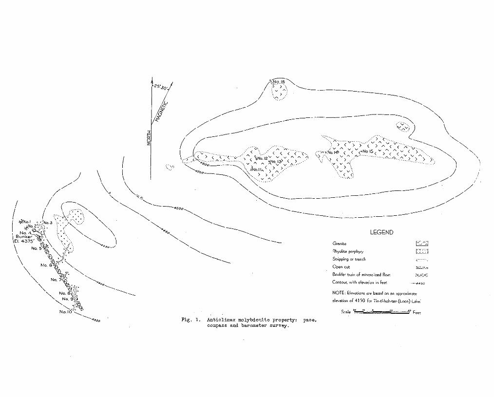
Fig. 1. Anticlimax molybdenite property: paca, compass and barometer survey.
c l a s e . The r a t i o of potash fe ldspar to soda- l ime fe ldspar i s a l i t t l e g r e a t e r t h a n a s 5 t o 3 which c l a s s i f i e s t h e r o c k as g r a n i t e . Because of the almost complete absence of dark min-
be c lassed as a n a l a s k i t e - an a l k a l i n e g r a n i t e w i t h no f e n i c s . e r a l s and t h e sod ic na tu re of t he p l ag ioc la se , t h i s rock could
Rhyol j . t e porphyry occurs in the a reas ind ica ted on F i g . (1). I t i s a l i gh t - co lou red rock i n which the qua r t z pheno-
microscope the rhyolite porphyry is seen t o be composed of c r y s t s , or eyes , a re a very conspicuous feature . Under th'a
phenocrysts of quar t z , mic rope r th i t e and a l b i t e - o l i g o c l a s e
minerals . from 1 mm. t o 2 . 5 mm. i n s i z e s e t i n a groundmass of t h e same
The r e l a t i o n of t h e r h y o l i t e p o r p h y r y t o t h e g r a n i t e was n o t e v i d e n t i n t h e f i e l d . However, t h e w r i t e r i n t e r p r e t s -the rhyol i te porphyry as a border phase of the gent ly-s loping 'but d e f i n i t e l y upper surface of t h e g r a n i t e s t o c k . D e f i n i t e dyke-
and i n d e f i n i t e c o n t a c t w i t h t h e g r a n i t e i s ind ica ted by a 'Tar- l i k e r e l a t i o n s t o the g ran i te were no t found, an i r regular
i a t i o n i n t e x t u r e . o f t h e r h y o l i t e p o r p h y r y t h a t i s not uni.?orm
r e s u l t of t h e i n t e r s e c t i o n of the uneven sur face of t h e ground i n any one d i r e c t i o n . This non-uniform variation may be t:?e
wi th t he i r r egu la r con tac t of t h e rhyol i te porphyry and g r a n i t e . This con tac t may t e n d t o conform to the gent ly-s loping upper su r face of the composi te grani te-rhyol i te porphyry s tock.
One l a rge , and several small masses of a p l i t e o c c u r i n t h e g r a n i t e and rhyol i te porphyry . P. l a r g e mass i n No. 4 p i t appears t o s t r i k e n o r t h e r l y and d ip gent ly eas tward . Wi th in t h e boundaries of t h e p i t t h e mass measures 50 f ee t a long the exposed dip- length by 15 feet a long the s t r ike by 6 f e e t a c r o s s
w e s t of Nos. 11 and 12 workings. I n t h e outcrop these are o r e - t h e d ip . Smaller bodies of a p l i t e occur i n t h e g r a n i t e t o t h e
s c e n t i c t o t r i a n g u l a r - s h a p e d a r e a s t h a t r a n g e From 2 i n c h e s t o 2 f e e t i n maximum dimension. Although they have no con t inu i ty the ap l i t e masses have sharp contacts against the g r a n i t e . I t i s p r o b a b l e t h a t t h e a p l i t e f i l l s . g a s h - l i k e o p e n i n g s i n t h e g r a n i t e .
Small i r regular pa tches of pegmatite measuring f r o m a few i n c h e s t o 2 f ee t i n d i ame te r , occu r i n t h e r h y o l i t e porphyry and a p l i t e of No. 4 p i t , and i n t h e s t r i p p i n g s immediately nor th-eas t of' t h e p i t . The pegmati te patches are very poorly def ined and merge in to the sur rounding rock . The pegmatite
po tash fe ldspar ; in p laces , as i n ?io. 4 pi t , molybdeni te oc- i s composed of abundant watery quartz and l e s s e r amounts of
curs in pegmat i te .
- 23 -

rhyol i te porphyry , on t h e o t h e r hand, i s cut by a g r e a t number The g r a n i t e i s massive and cut by only a few jo in ts . The
of jo in ts , spaced from 2 t o 6 inches apar t , which s t r ike nor th
r ecogn i sab le f ea tu re s a r e a long t he no r th -eas t s ide of No. 4 73 degrees west and dip 80 degrees north-eastward. The only
p i t . One of t hese cons i s t s on ly o f a pape r - th in f r ac tu re that follows a jo in t -p l ane ; t he o the r , i s a f r a c t u r e o n l y 1/4 of a n inch in wid th , t ha t s t r i kes no r th 30 deg rees wes t and :d ips 75
has been no mea'surable displacement . Apart f rom the main ore- degrees south-westward; it d e f i n i t e l y c u t s t h e first, b u t t h e r e
l e n s i n No. 4 p i t , many narrow veins and s t r ingers o f quar tz
These veins s t r ike approximately north 25 degrees west and d i p and molybdenite cut the g r a n i t e t o t h e e a s t o f No. 4 p i t .
p inch ing ou t t o a mere jo in t w i th in d i s t ances r ang ing from 2 steeply north-eastward. They a re d i scon t inuous i n l eng th ,
t o 20 f e e t . They r e p r e s e n t j o i n t s i n t h e g r a n i t e t h a t have subsequent ly been f i l l ed .main ly by quar tz .
The mineral-assemblage i s def in i te ly h igh- tempera ture
grained molybdenite i s evenly disseminated in pegmati t ic quartz and c lose ly related t o t h e formation of pegmatites. Medium-
and f e ldspa r and i n w a t e r y q u a r t z t h a t i s a d j a c e n t t o pegma-
amounts of molybdenite occur elsewhere in narrow quartz veins t i t i c a r e a s and undoubtedly pegmati t ic i tsel f in or igin. Small
ness. In add i t ion t o mo lybden i t e , small amcunts of pyrite, and s t r i n g e r s that range from 1/2 a n i n c h t o 8 i n c h e s i n t h i c k -
e r s . I t may be no ted t ha t t he a lka l ine na tu re of the enc los ing s p h a l e r i t e and f l u o r i t e o c c u r i n t h e s e q u a r t z v e i n s and s t r i n g -
g r a n i t e and rhyol i te porphyry would presuppose small amounts
molybdenite i s most abundant where associated with the pegma- of f l u o r i t e p r e s e n t i n t h e accompanying vein-matter. The
t i t e and pegmati t ic quartz of No. 4 p i t , and i s much l e s s abun- dant i n t h e nerrow quartz veins and s t r inge r s e l s ewhere on t h e proper ty . ' .
minera l ized lens has been la rge ly removed. However, it i s r e - ported t o have comprised a gent ly-dipping lens approximately 8 f ee t i n d i ame te r by 2 f e e t t h i c k . Remnants of t h i s l e n s a s seen on t h e n o r t h - e a s t s i d e of t h e p i t c o n s i s t of molybdenite r e p l a c i n g a p l i t e a l o n g i l l - d e f i n e d p l a n e s t h a t s t r i k e n o r t h 65 degrees west and d i p 25 degrees north-eastward. Rearants of t h e same l e n s a s s e e n on the south-wes t s ide , cons is t of an exposure of molybdeni te minera l iza t ionmeasur ing 8 f e e t i n length by 2 f e e t i n d e p t h by 1 f o o t i n exposed wid th ; in th i s
quartz and a small amount o f f e l d s p a r . p a r t o f t h e lens the molybdeni te i s assoc ia ted wi th watery
The main occurrence of molybdenite i s i n No. 4 p i t . The
Aithough the molybdenite of the minera l ized lens has sev-
- 24 -

era1 minera l -assoc ia t ions , it appears to be most commonly a s - soc ia ted wi th pegpat i t ic quar tz and fe ldspar . I t i s found r e - p l ac ing rhyo l i t e po rphyry i n a few places, more commonly r e - p l a c i n g a p l i t e and most commonly a s soc ia t ed w i th t he wa te ry quartz and fe ldspar of pegmati t ic patches. In the pegmati te . , quar tz i s much more abundant than the fe ldspar , and s ing le hand-specimens of t he mine ra l i za t ion wrong ly sugges t t ha t t he molybdenite i s assoc ia ted wi th on ly quar tz . The pegmati t ic mater ia l occurs as irregular patches. , ranging from 6 inches t o 2 f e e t i n d i a m e t e r , and occurs both in the rhyol. i te porphyry and t h e a p l i t e .
There i s a wide var ia t ion in the molybdeni te conten t . A sample taken f r o m a 10-inch specimen of h igh-grade mater ia l in the ore-bin assayed: Molybdenite 10.8 per cen t . ; another
deni te 5 .8 per cent . sample from a 12-inch specimen of'high grade assayed: Molyb-
B sample taken across 2 f e e t of the remnant of t h e l e n s as exposed on the south-west s ide of the pi t assayed: Molyb- d e n i t e 1 .4 per cent . A 10-pound sample approximately repre-
cent . A sample taken across 14 inches of a p l i t e and banded. s e n t a t i v e of the o re in the b in assayed: Molybdeni te 1.1 per
molybdeni te in the nor th-eas t s ide of t h e p i t a s s a y e d : Mo3.yb- d e n i t e 0.4 per cent,.
The workings w i l l be descr ibed in sequence as they art: numbered on Fig. (1).
No. 1 has been driven as an open-cut f o r 22 f e e t i n a d i r e c t i o n n o r t h 5 5 d e g r e e s e a s t t o a n 8 - f o o t , . o a v e d f a c e . The cu t i s mostly in overburden, and exposes only a small amount of rhyol i te porphyry a t t h e f a c e .
No. 2 i s similar t o No. 1.
No. 3 c o n s i s t s of i r r e g u l a r s t r i p p i n g s t h a t e x p o s e a
PhYrY. l i t t l e a p l i t e and two patches of pegmat i t e i n rhyo l i t e po r -
No. 4 i s t h e c u t i n which the minera l ized lens was found. It i s a l a rge i r r egu la r cu t measu r ing 60 f e e t i n a north-vres- t e r l y d i r e c t i o n by 10 f e e t i n a n o r t h - e a s t e r l y d i r e c t i o n ; t h e face on the nor th-eas t and south-eas t ranges f r o m 2 t o 1 5 f e e t i n h e i g h t and the south-west from 1 f o o t t o 3 f e e t ; t h e n o r t h - west end of t h e c u t i s , open.
No. 4 p i t exposes a 1.arge body of ap l i t e w i th in rhyo : l i t e porphyry. The a p l i t e i s exposed i n a l l b u t t h e e a s t e r l y , and
- 25 -
i n t h i c k n e s s by 53 fee t exposed d ip l ength ; it s t r i k e s n o r - souther ly corners of t h e c u t and i s a body of a t l e a s t 6 f e e t
t h e r l y and d.ips gent ly eas tward . The molybdenite lens and as-
l i t e ; b o t h a r e p r o b a b l y g e n e t i c a l l y r e l a t e d t o t h e a p l i t e . . soc i a t ed pegmat i t i c ma te r i a l l i e a lmos t who l ly w i th in t h i s ap -
rhyol i te porphyry. The eas te r ly , and souther ly , corners of t h e c u t c o n s i s t of
A small f a u l t f r a c t u r e 1/4 of an inch i n w i d t h , s t r i k e s nor th 30 degrees west and dips 75 degrees south-westward close t o t h e n o r t h - e a s t s i d e of t h e p i t ; it c u t s t h e e a s t e r l y p a r t of the minera l ized lens bu t does no t d i sp lace it. The f a u l t - f r a c t u r e i s unmineral ized and consis ts only of crushed rock.
l e n s a r e c u t b y many unmineral ized joints , ' spaced f rom 2 t o 6 All t he rock , rhyo l i t e po rphyry , ap l i t e and mineralized
inches apa r t , and which s t r i k e n o r t h 73 degrees west and dip 80 degrees north-eastward. The assays of samples taken from t h e m i n e r a l i z e d l e n s i n t h i s p i t have been described above.
No. 5 i s an open-cut that has been d r iven i n a d i r e c t i o n nor th 57 degrees eas t for 30 f e e t . The c u t i s badly caved and no rock i s exposed.
No. 6 i s a s t r ipp ing t ha t exposes on ly rhyo l i t e po rphyry .
No. 7 i s in overburden , and sloughing has covered the rock.
No. 8 i s a l a r g e t r e n c h , 6 f e e t w i d e t h a t e x t e n d s i n a d i r e c t i o n n o r t h 2 0 deg rees ea s t for 40 f e e t a c r o s s j o i n t e d r h y - o l i t e po rphyry .
f e e t i n a d i r e c t i o n n o r t h 10 degrees ea s t ac ross j o in t ed rhy - No. 9 i s a narrow t rench 2 1/2 f e e t w i d e t h a t e x t e n d s 75
o l i t e porphyry.
No. 10 t r ench i s in overburden.
No. 11 i s an ope?-cut that has been driven in so l id rock
rock-face a t the base o f a low rock-b luf f . The rock i s medium- i n a d i r e c t i o n n o r t h 2 0 d e g r e e s e a s t for 4 f e e t t o a 7-foot
g r a i n e d g r a n i t e t h a t c o n t a i n s a small amount of molybdenite and f l u o r i t e .
No. 1 2 i.s a combined s t r i p p i n g and p i t ; t h e s t r i p p i n g i s 10 f e e t wide and extends for 2 0 f e e t in a d i r e c t i o n s o u t h 23 d e g r e e s e a s t t o t h e edge of t h e p i t LO f e e t s q u a r e by 6 f e e t deep. The p i t exposes a 1- inch quartz-molybdeni te s t r inger
- 26 -

wel l d e f i n e d i n t h e smooth rock-surface of t h e s t r i p p i n g ; along t h e no r th -eas t wa l l . G l a c i a l f l u t i n g m d s t r i a e a r e
t h e d i r e c t i o n of glacier-movement as indicated by f luting and s t r i a e i s south 23 degrees eas t . This d i r e c t i o n c o r - responds very c lose ly wi th , the a l ignment of o r e - f l o a t i n t h e boulder - t ra in (F ig . (1)) .
No. 13 i s a sha l low p i t 2 fee t deep tha t measures 8 f e e t
poses a s h o r t , 1/2 i nch s t r inge r i n g ran i t e ; t he s t r i nge r con - i n a n o r t h e r l y and 4 f e e t i n an e a s t e r l y d i r e c t i o n . I t ex-
t a i n s q u a r t z , p y r i t e , f l u o r i t e and a l i t t l e molybdenite.
deep and measures 10 fee t i n an ea s t e r ly and 4 f e e t i n a nor- t h e r l y d i r e c t i o n . A few s t r i n g e r s of quar t z , 1 inch wide, f o l l o w nor th -wes te r ly s t r i k ing j o in t s . h small mount of spha le r i t e , bu t no molybdenite, was s e e n i n t h e q u a r t z .
No. 15 is a p i t 4 feet deep and 4 f e e t s q u a r e on a quar tz ve in , 8 t o 10 inches w ide , t ha t s t r i kes no r th 13 de - grees west and dips 85 degrees south-westward. This vein con- t a ins on ly a l i t t l e molybdenite. A few small s t r ingers of q u a r t z , p y r i t e and s p h a l e r i t e a l s o c u t t h e g r a n i t e .
No. 14 i s a n i r r e g u l a r p i t i n g r a n i t e . The p i t i s 2 f e e t
No. 16 i s a s t r i p p i n g 26 fee t long tha t ex tends south-
ping follows a d i scon t inuous , l en t i cu la r quar tz v e i n t h a t e a s t e r l y t o t h e edge of a l a r g e a r e a o f g r a n i t e . The s t r i p , -
ranges from 1 i n c h t o 8 inches i n t h i ckness . The vein-matt,zr c o n s i s t s of q u a r t z , p y r i t e an.d a l i t t l e molybdenite, sphaler- i t e and f l u o r i t e . . The r o c k i n t h e s t r i p p i n g , and adjacent
dyke-like body of r h y o l i t e porphyry a t the sou th -eas t e r ly end outcrop south-eas te r ly , i s all gran i t e excep t f o r an i so l a t ed
o f t h e outcrop. This dyke i s 4 f e e t wide and s t r ikes e a s t .
F.urther prospecting, i f done, should either (1) fcl1o.w a p o s s i b l e r e p e t i t i o n of the minera l ized- lens BS i n ?To. 4 ,
t u r e of exaTinat ion of a l l f loa t a round the per iphery of t h e e i t h e r down t h e d i p o r a l o n g t h e s t r i k e , o r ( 2 ) be i n the na-
s tock . A r e p e t i t i o n of s t r u c t u r e s i m i l a r t o , t h a t i n No. 4 p i t i s possible and the presence of other lenses might be shown by min.eralized-boulders in the f l o a t . The source of any f loa t cou ld be de t e rmined i n a s i m i l a r manner t o t h a t of t h e No. 4 occurrence, as i s descr ibed in the fol lowing para- graph.
covery of molybdenite f l o a t t o i t s o r ig in . The f l o a t was found Mineral in place i n No, 4 p i t was made by following a d i s -
on a wooded h i l l s i d e , so wel l covered by overburden that pros- pec t ing cons is ted of searching t h e g l a c i a l - t i l l f o r mineral ized

boulders and digging several cross- t renches. The discovery of f l o a t was made i n t h e v i c i n i t y of t r e n c h No. 10 see F ig .
outcrop of molybdenite was found i n No. 4 p i t . Most o f t h i s (1 ) and t renches Nos. 10 t o 5 inc lus ive were dug before the
f l o a t h a s been d i s t r i b u t e d by g l a c i a l a c t i o n . T h i s i s shown by t h e p a r a l l e l i s m ( s e e P i g . (1)) between the a l ignment of t h e v a r i o u s p o s i t i o n s i n which the mineral ized-boulders were found, t h a t i s , the a l ignment of t he bou lde r - t r a in , and of g l a - c i a l f l u t i n g and s t r i a e on outcrops on t o p of t h e h i l l . The d i r e c t i o n of t he bou lde r - t r a in as mapped i s south 30 degrees e a s t , a n d t h a t of t h e f l u t i n g and s t r i a e i s south 23 degrees e a s t ; t h e i n d i c a t e d d i r e c t i o n of movement of t h e i c e i s from north-west t o s o u t h - e a s t .
KENALLAN MOLYBDENITE a l lan property has been recent ly Ground formerly compris ing the Ken-
PROPERTY ( 2 1 ) the mineral c la ims Numbers 1 t o 6, r e - s t a k e d a s a g roup t ha t i nc ludes
gus t and September, 1939 by R . and P . L . Fitzmaurice, Otto Sand i n c l u s i v e , and t h e Oak Fract ional . These were s taked i n A:-
berg and P. W. Groves. This property was examined by t h e w r i t e r i n August, 1939.
Westwold, formerly known a s Grande P r a i r i e , a v i l l a g e 35 mi l e s The p rope r ty l i e s app rox ima te ly 4 miles south-west of
may be reached by following the Westwold-Douglas Lake highway e a s t of Kamloops on t h e Ramloops-Vernon hlghway. The proper ty
f o r 4 miles souther ly f rom Westwold, thence by an old logging- road f o r 1 1/4 mi l e s no r th -wes te r ly t o t he p rope r ty ; t he l ogg ing- road i s passable by car f o r 3/4 of a mi le fro!n t h e highway.
The workings are on the l ong t op and nor thern s lope of an openly-wooded, round-topped h i l l , t h e maximum height of which i s approximately 300 feet above the end of t he , pas sab le s ec t ion of the logging-road .
i n which m e o r i g i n a l l i m e and argi l laceous sediments have been replaced by l ime-s i l i ca t e mine ra l s and by molybdenite. The molybdenite occurs as a minor c o n s t i t u e n t i n b e d s of l i m e - s i l i -
t h e r l y s t r i k i n g z o n e s . The wes te r ly zone i s exposed by sur- cate rock. These beds of l ime- s i l i ca t e rock occu r i n two nor-
t h e c r e s t of t h e r i d g e . The e a s t e r i y zone i s exposed by an in- f a c e c u t s Numbers 1 t o 15 inc lus ive , and by a s h o r t i n c l i n e on
c l i n e and a v e r t i c a l s h a f t , wo'rkings Numbers 17 and 18, on t h e
as exposed by workings, i s 1 , 0 0 0 f e e t , and al though the maxi- ea s t e rn s lope of t h e r i d g e . The length of the wester ly zone
mum width of t h e zone i s 100 f e e t , t h e w i d t h of t he i nd iv idua l l i m e - s i l i c a t e beds ranges from only a few inches to 4 f e e t .
The Kenallan i s a high-temperature replacement deposi t
- 28 -

The length of t h e e a s t e r l y zone, as exposed by t h e i n c l i n e
t h i s i s a l so t he w id th o f t he l ime- s i l i ca t e bed. and v e r t i c a l s h a f t , i s 150 f e e t and t h e maximum width 1 2 f e s t ;
Molybdeni te occurs a lmost exclusively within the l ime-
t r a t e d i n t o a r e a s of heavy mineral izat ion. The bes t ma te r i a l s i l i c a t e b e d s . I t i s widely scat tered and is nowhere conce:n-
found i s t h a t which comprises the dump f o r No. 6 working, a
t he s tope . A 250-lb. sample representative of t h e dump mater- combined underhand. s tope and shor t inc l ine from t h e bottom of
ia l , taken by the wri ter assayed: Molybdeni te , 0.5 per cen t . ; copper; t race; i ron, 1 . 9 per cen t .
The rocks a s soc ia t ed w i th t he l ime- s i l i ca t e rock ' a r e i n t e r - bedded c rys t a l l i ne l imes tone and hornfe ls . The beds range in s t r i k e f r o m no r th 15 degrees wes t to nor th 10 degrees ea s t and i n d i p f r o m 40 degrees t o 50 degrees westward. The l i m e - s i l i - ca te rock and the l imestone range in thickness from a fe7.f i n - ches t o 4 f e e t . The e n t i r e w i d t h of t h e h o r n f e l s was seldom exposed, but widths up t o 1 2 f e e t ' have been seen.
The l ime-s i l i ca t e rock i s a dense, predominant ly l ight-
der of abundance: diopside, l ime-garnet, epidote, wollaston- g r e e n r o c k t h a t c o n t a i n s t h e f o l l o w i n g m i n e r a l s l i s t e d i n o r -
i t e and ax in i te .
t h a t h a s a s l ight ly brownish hue. I t cons i s t s of a mosaic of quartz and small amounts of f e ldspa r and b i o t i t e .
The ho rn fe l s i s a very f ine-grained, dark-green rock,
The l imestone i s a medium-grained, white rook cons i s t ing almost exclusively of c a l c i t e .
Towards t h e n o r t h end of t h e w e s t e r l y zone, and pa r t i cu - l a r l y i n t h e e a s t e r l y zone, t h e r o c k s a r e c u t by d i o r i t e s i l l s and tongues. This dior i te i s a medium-grained rock, c0ntai.n- ing feldspar and amphibole. The presence of patches of lime-
d i o r i t e has intruded the sediments , i t s i n t r u s i o n definite1.y s i l i c a t e minera ls and 'molybdenite, i n d i c a t e t h a t although tihe
preceded the replacement o f these rocks by l i m e - s i l i c a t e s and molybdenite. The mineralizing solutions, however, probably came from areas of g r a n i t e , r a t h e r t h a n from t h e d i o r i t e . An a r e a of g ran i t e ou tc rops 150 fee t nor th-wes ter ly from No. 1.5 p i t .
Beginning a t a po in t 150 f ee t no r th -wes te r ly f'rom No. 15 p i t , a n a r e a of grani te approximately 50 feet wide, extend8
of pegmati t ic mater ia l and on the nor th-wes ter ly end a l ens of for 200 f e e t t o t h e n o r t h - w e s t . T h i s g r a n i t e c o n t a i n s c1oi;s
- 29 -
quartz-feldspar pegmati te , measuring 10 feet i n a n o r t h e r l y clirection and 3 f e e t i n a n e a s t e r l y d i r e c t i o n . T h e ' g r a n i t e
from grey t o p ink i n co lou r . The composition ranges from i s medium i n g r a i n and v a r i e s w i t h t h e o r t h o c l a s e c o n t e n t
t h a t of g r a n o d i o r i t e . t o that of a t rue g ran i t e . Th i s a r ea of g r a n i t e i s bounded by ho rn fe l s and c rys t a l l i ne l imes tone .
..I
The surface workings w i l l be descr ibed consecut ively, beginning f rom the southernmost t rench on t h e t o p of t h e r i d g e and proceeding northerly.
been driven i n a n o r t h e r l y d i r e c t i o n f o r 1 2 f e e t . The rocks s t r i k e n o r t h and dip westward. One foo t of g rey l ime- s i l i ca t e r o c k l i e s i n a foot -wal l of ho rn fe l s . .No molybdenite was seen.
No. 1 i s a t r ench 4 fee t wide and 4 f e e t d e e p t h a t h a s
10 f e e t l o n g i n a n o r t h e r l y d i r e c t i o n , i s 90 f e e t in a d i r e c - No. 2 , a sha l low s t r ipp ing 4 fee t wide by 2 f e e t deep, by
t i o n n o r t h 7 degrees east . f rom No. 1. A s c o n t r a s t e d t o No, 1, t h e l i m e - s i l i c a t e r o c k l i e s i n t h e h a n g i n g - w a l l of r u s t y horn- f e l s . The rocks s t r i ke no r th 15 deg rees wes t and d ip 35 de- grees westward. No molybdenite was seen.
7 f e e t wide ty 3 f ee t deep , i s 45 f e e t i n a d i r e c t i o n n o r t h 2 degrees west from No. 2 . I t cu t s t he fo l lowing s ec t ion of rock: 4 f e e t of l imestone in the hanging-wall , then 3 fee t o f l ime- s i l i c a t e r o c k , t h e n 2 f e e t o f r u s t y h o r n f e l s . No molybdenite was seen.
No. 3, a t r e n c h 8 f e e t l o n g i n a n o r t h e r l y d i r e c t i o n by
No. 4, a t r ench d r iven 28 f e e t w e s t e r l y a c r o s s t h e s t r i k e o f t h e r o c k s t o a &foot face, i s 75 f e e t i n a d i r e c t i o n n o r t h 5 degree west from No. 3. The t rench exposes 3 lL2 f e e t o f l imestone on the hanging-wall , and 3 f e e t of g reen l ime- s i l i ca t e
gra ined ep idote , and then 6 f e e t of hornfe ls . A small amount rock i n t ne foo t -wa l l , some of which contains abundant fine,-
of molybdenite and chalcopyrite were seen admixed with dark- brown c r y s t a l l i n e g a r n e t .
No. 5 , a n i r r e g u l a r p i t 5 f e e t deep measuring 25 f e e t i n a n o r t h e r l y d i r e c t i o n and 15 fee t in a w e s t e r l y d i r e c t i o n , i s 60 f e e t i n a d i r e c t i o n n o r t h i0 degrees west from No. 4. The same succession of rocks occurs as in No. 4. In t h i s p i t t h e
p l e a x i n i t e was s e e n i n t h e l i m e - s i l i c a t e . The only molybden- l imestone bed i s d e c i d e d l y l e n t i c u l a r . A small amount of pur-
i t e s e e n was i n a small dump a t t h e s i d e of t h i s p i t .
i n a d i r e c t i o n n o r t h 10 degrees west from No. 5. From t h e No. 6, an open-cut driven 2 0 f e e t w e s t e r l y , i s 60 f e e t
- 30 -

west end of t h i s c u t a drift-working extends 25 fee t souther - l y , and from t h e f l o o r of this dr i f t -working, an underhand- s tope extends down t h e d i p of the sediments f o r 15 f e e t . The
of l imestone in the hanging-wall and hornfels in the foot-wal l . s tope i s i n a 42-inch band of l ime- s i l i ca t e rock , w i th 4 f e e t
These rocks s t r ike north 15 degrees west and d ip 40 degrees westward.
but a cons iderable amount of molybdenite-bearing rock estimated a t approximately 100 tons has been taken f r o m the dr i f t -working and inc l ine , a s i nd ica t ed by a nearby dump.
Only a l i t t l e molybdenite was seen i n t he p re sen t f aces ,
p ieces of ore f r o m var ious places on and i n t h e dump. A 250- The w r i t e r sampl.ed t h i s dump by t a k i n g r e p r e s e n t a t i v e
Mines Sampling P lan t a t Prince Rupert f o r crushing and reduc- pound sample of t h i s m a t e r i a l was s e n t t o t h e Department of
t i o n . The sample assayed: Molybdenite, 0.5 per cent.; copper, t r ace ; i ron , 1 . 9 per cen t .
as t h e d r i f t i n No. 6 working, but here the beds s t r ike north, i s 60 f e e t i n a d i r e c t i o n n o r t h 60 degrees west from west end of the open-cut a t No. 6. E igh t f ee twes te r ly f rom No. 7 a. second s t r ipping exposes a l i m e - s i l i c a t e bed 4 f e e t t h i c k . The sucoess ion o f rocks t o t he ea s t of t h i s s t r i p p i n g i s ; lime- s tone, 2 f e e t ; l i m e - s i l i c a t e r o c k , 4 fee t ; l imes tone , 2 . f e f t ; l i m e - s i l i c a t e , 3 f e e t ; h o r n f e l s . A small amount of molybden- i t e was seen.
No. 7, a s t r i p p i n g t h a t f o l l o w s t h e same l i m e - s i l i c a t e bed
No. E , a t r ench 4 feet deep measuring 35 f e e t i n a nor-
from No. 7. This t rench appears t o be i n t h e w e s t e r n . b e d c f t h e r l y d i r e c t i o n and 5 f e e t i n w i d t h , i s 70 f e e t n o r t h e r l y
l i m e - s i l i c a t e t h a t e x t e n d s f r o m Wo. 7; 3 f e e t of l imestone o v e r l i e s t h e l i m e - s i l i c a t e . The beds s t r i k e n o r t h 10 degrees e a s t and d i p 45 degrees westward. A s l i g h t bend t o t h e e a s t
Only a small amount of molybdenite was seen. seems t o have occurred i n t h e r o c k s between No. 7 and No. E .
No. 9, a p i t 8 fee t deep and 4 f ee t i n d i ame te r , i s 90 f e e t i n a d i r e c t i o n n o r t h 60 degrees eas t f r o m No. E . The
grees westward; they are bounded on the sou th by a v e r t i c a l r o c k s i n t h i s p i t s t r i k e n o r t h 1 0 d e g r e e s w e s t , and dip 50 de-
f a u l t that s t r i k e s n o r t h 60 degrees eas t . The cont inuat ion. of the l ime-s i l ica te beds nor ther ly f r o m No. 8, appea r s t o be o f f s e t i n an eas te r ly d i rec t ion towards the pos i t ion of No. 9 p i t . The succession of rocks in No. 9 from w e s t t o e a s t i s : l ime- s i l i ca t e rock , 2 f e e t ; h o r n f e l s , 2 f e e t ; ' d i o r i t e s i l l , 14 inches; hornfels, 3 f e e t .
- 31 -

No. 10, a t r e n c h 3 f ee t deep , measu r ing 15 f ee t i n an e a s t e r l y d i r e c t i o n and 4 f e e t i n w i d t h , i s 40 f e e t i n a d i r ec - t i o n n o r t h 30 degrees west from No. 9. A small patch of horn- f e l s i s exposed i n t h e w e s t e r n end.
?To. 11, a p i t 3 f e e t d e e p and 6 f e e t i n d i a m e t e r , i s 70 f e e t i n a d i rec t ion nor th 40 degrees eas t f rom No. 10. From w e s t t o e a s t it exposes 1 foo t of l imestone, 3 f e e t of lime- s i l i c a t e r o c k and then ho rn fe l s .
No. 1 2 , a p i - t 2 feet deep and 5 f e e t i n d i a m e t e r , is 100 feet northward from No. 11. Prom w e s t t o e a s t t h e s u c c e s s i o n
f e e t of l ime- s i l i ca t e rock . Wol l a s ton i t e was s e e n i n t h i s p i t . i s : 2 f e e t of l ime- s i l i ca t e rock ; . 1 2 . f e e t of limestone; and 3
No. 13, a p i t 4 f e e t d e e p and 5 fee. t square, i s 175 f ee t i n a d i r e c t i o n n o r t h 5 degrees east f rom No. 1 2 . The rocks s t r i k e n o r t h 4 deg rees ea s t and d i p 45 degrees westward. From wes t t o ea s t t he success ion i s : 6 inches of l i m e - s i l i c a t e ; 1 2
f e l s . Although t h e d i o r i t e i s d e f i n i t e l y i n t r u s i v e i n t o t h e inches of d i o r i t e ; 5 f e e t o f l ime-s i l ica te rock; and then horn-
assoc ia ted rocks , it has been i n pa r t r ep laced by l i m e - s i l i - c a t e s m d by molybdenite.
No. 14, a p i t 2 f e e t d e e p and 5 f e e t in diameter, i s 40 f e e t i n a d i r e c t i o n n o r t h 25 degrees east f rom No. 13. The rocks a r e similar t o t h o s e i n No. 13,
No.: 15, a t r ench t ha t ex t ends 10 fee t sou th -wes te r ly , i s
of d i o r i t e . 3 f e e t of ho rn fe l s and . some l ime- s i l i ca t e i n t h e 50 f e e t n o r t h e r l y from No. 14. This trench^ cu t s ac ross 2 f e e t
foo t --Mal 1.
In genera l , workings No. 1 t o 15 inclusive, fol low one westerly zone, of l ime- s i l i ca t e beds . However, t h i s w e s t e r l y zone can be sub-divided into possibly f ive separate l ime-
a second by Mos. 7 and %, a t h i r d ' by Nos. 9 and 10, a f o u r t h s i l i c a t e b e d s ; one bed i s exposed by Nos. 1 t o 7 i n c l u s i v e ,
by Nos. 11 and 1 2 , and a f o u r t h a n d f i f t h by Nos. 1 3 t o 1 6 in- c lus ive . The maximum width of t h e zone of l ime-s i l ica te beds i s 100 f e e t ; but the individual beds range from only a few i n c h e s t o 4 fee . t .
No. 16, a t r e n c h 1 5 f e e t l o n g i n a n e a s t e r l y d i r e c t i o n , i s 360 f e e t .in a d i r e c t i o n n o r t h 42 degrees west from Fo. 15. I t ex tends ac ross t he no r the rn end of a pegmati te lens 10 f e e t long by 3 f ee t w ide ; t he pegmat i t e con ta ins on ly qua r t z and p ink fe ldspar .
- 32 -

t e r l y d i r e c t i o n f o r 9 f e e t , i s 400 f e e t i n a d i r e c t i o n n o r t h No. 1 7 , an i n c l i n e sunk on a 40-degree slope in a wes-
85 degrees east from No. 15. This incline measures 1 2 fee.1;
f o r 50 ' f e e t t o t h e s o u t h . The r o c k s i n t h i s i n c l i n e c o n s i s t i n a nor ther ly d . icec t ion and extends as an i r r egu la r s t r i pp ing
of hornfels and cro.ss-cut t ing tongues of d i o r i t e : o n l y a few patches of l ime-s i l ica te rock and a l i t t l e molybdenite were seen.
No. 18, a sha f t , 1 2 f e e t in d i ame te r t ha t i s 'now f i l l e d wi th water and inaccess ib le , i s 150 feet northward from No.. 17 . I t has been sunk ent i re ly in l i m e - s i l i c a t e r o c k . Only sma1.l amounts of molybdenite were seen.
The Sands Creek molybdenite Occurrence SANDS CREEK and adjacent ground appears to be cov- MOLYBDENITE (24). ered by t h e No.. 1 and No. 2 Sands Creek -
1939 and owned by Gordon and I. A. Bennett of' Clearwater, and, by t h e Morning Star c la im, s taked on December 30, 1939 and owned by J. L..Carden. The w r i t e r examined th is occur rence in June , ' 1938.
Molybdenum claims s taked on Apr i l 2 1 ,
The occurrence i s a small showing o f molybdeni te that occu r s i n t he sou th bank o f Sands Creek: a small creek tha- t f lows westerly into the Clearwater River and crosses the Clear- water road a t a point about 1 1/2 miles back or t o t h e n o r t h of t h e main North Thompson highway near Clearwater Stat ion,
The showings a r e 700 f e e t down-stream f r o m t h e road crossiing. (Canadian National Railway) about 76.miles north of Kam1oo:ps.
mary Report, Geological Survey of Canada, 1930, Part A, This property has been br ief ly descr ibed by Walker i n t h e Sum-
p. 153-A.
l e n s e s i n t h e bank of t he c r eek . Two of t h e s e a r e c l o s e t o t h e t o p of the 30- foot bank and t h e t h i r d i s halfway down the bank a t t h e b a s e of a 15-foot rock bluff t h a t extends down from the upper showings.
The workings consis t of a l i t t l e b l a s t i n g on t h r e e q w r t z
The uppermost showing i s a l e n s o f bar ren quar tz , 6 f e e t
no r th 70 degrees e a s t and dips 7 degrees southward. long by 18 inches t h i c k in i t s t h i c k e s t p a r t , that s t r i k e s ~
A t abou t t he same l e v e l i n t h e bank and 20 f e e t e a s t e r l y , a &foot zone of q u a r t z s t r i n g e r s c u t s a p l i t i c g r a n i t e . These s t r i n g e r s , s t r i k e n o r t h 70 deg rees ea s t and d i p 6.0 degrees southward and carry a small amount o f molybdenite. A sample t aken ac ross t he zone assayed: Molybdenite, 0.1 per cent.
- 33 -

A s h o r t d i s t a n c e beloiv t h e q u a r t z l e n s f i r s t descr ibed , a t h i r d s h w i n g c o n t a i n i n g a small amount of molybdenite, ex- tends d iagonal ly nor th-eas te r ly down t h e bank of t he c r eek for approximately 20 f e e t . T h i s q u a r t z s t r i k e s n o r t h 5 0 d e - g r e e s e a s t and d i p s 80 degrees southward, and ranges i n width from 3 i n c h e s t o 8 inches. A sample taken across 6 inches of vein-matter near the upper end assayed: Molybdenite, 0.3,: per cen t , and one cons i s t ing of selected dump-mater ia l as- sayed: Molybdenite, 0.78 per cent. This occurrence i s i n coa r se -g ra ined g ran i t e s imi l a r t o t ha t of t h e second showing.
BOSS MOUNTAIX ( 2 5 ) . e r t y on Boss Mountain (Big Timothy The Boss Mountain Molybdenite prop-
M t . ), i n t h e Q u e s n e l Mining Divis ion, i n c l u d e s t h e Crown-granted mineral claims, Tooty Fruity, %-
Adanac F rac t ion and Adanac No. 1; these c la ims were located a l d i n e , B l a c k , -, Adanac, Bonnie, Adanac No. 2 , Tip Top,
a t v a r i o u s times between 1928 and 1935, and a r e a t p r e s e n t
ada, Limited of Tadanac, B r i t i s h Columbia. The property was owned by the Consolidated Mining and Smelting Company of Can-
examined by t h e w r i t e r i n J u l y , 1 9 3 7 .
120 degrees 56 minutes and la t i tude 52 degrees 06 minutes north, l i es approximate ly 45 mi les nor th-eas t of Lac la Hache.
Boss Mountain (Big Timothy M t . ) ( P l a t e I B) a t l o n g i t u d e
The Boss Mountain a rea may be reached by a t l e a s t t h r e e d i f f e r e n t r o u t e s , b u t t h e b e s t i s by 25 mi l e s of poor motor- road, passable by c a r s w i t h good clearance, from Lac l a Hache
Lake Ranch on t h e western end of Murphy (Eagle) Lake, ( e l e - ( e l e v a t i o n 2,650 f e e t ) on t h e Cariboo Highway, t o t h e Eagle
va t ion 2 ,875 fee t ) , thence by pack-horse t r a i l for approxi- mately 20 miles t o t h e p a s s o v e r Boss Mountain, a t an e leva- t i o n of 6 ,750 fee t , and down t o t h e camp-cabin a; an e l e v a t i o n of 5 ,550 f ee t on t h e s o u t h - e a s t e r l y s i d e of t h e maintain. The camp-cabin i s on t h e n o r t h e r n bank of the eas te rn headwater t r i b u t a r y of Molybdenite Creek. This tr ibutary f lows t o t h e n o r t h i n t o McKinley Creek and thence into the Horsef ly River .
The two o t h e r r o u t e s a r e (1) v i a a pack-horse t r a i l t h a t l eads from Vaughan's ranch (Pre-emption L o t No. 104 on Quesnel Sheet, Map No. 3 - G , procurable a t Dept. o f Lands, Victor ia) , now abandoned, 8 mi l e s a long t he road t o t he no r th f rom Lac la Hache, no r th -eas t e r ly pas t t he ea s t end of Spout Lake, by Geo. Borthivick's ranch (Pre-emption Lot No. 9105 on Quesnel Sheet) on t h e e a s t end of Murphy (Eagle) Lake, thence north-easter ly t o t h e p r o p e r t y , and ( 2 ) by pack-horse t r a i l t o t h e n o r t h from Fores t Grove, a v i l l a g e 9 . m i l e s e a s t ' of Canim'Lake, t o Geo. Borthwick's ranch (Pre-emption Lot No, 9105 on Quesnel Sheet),
- 34 -
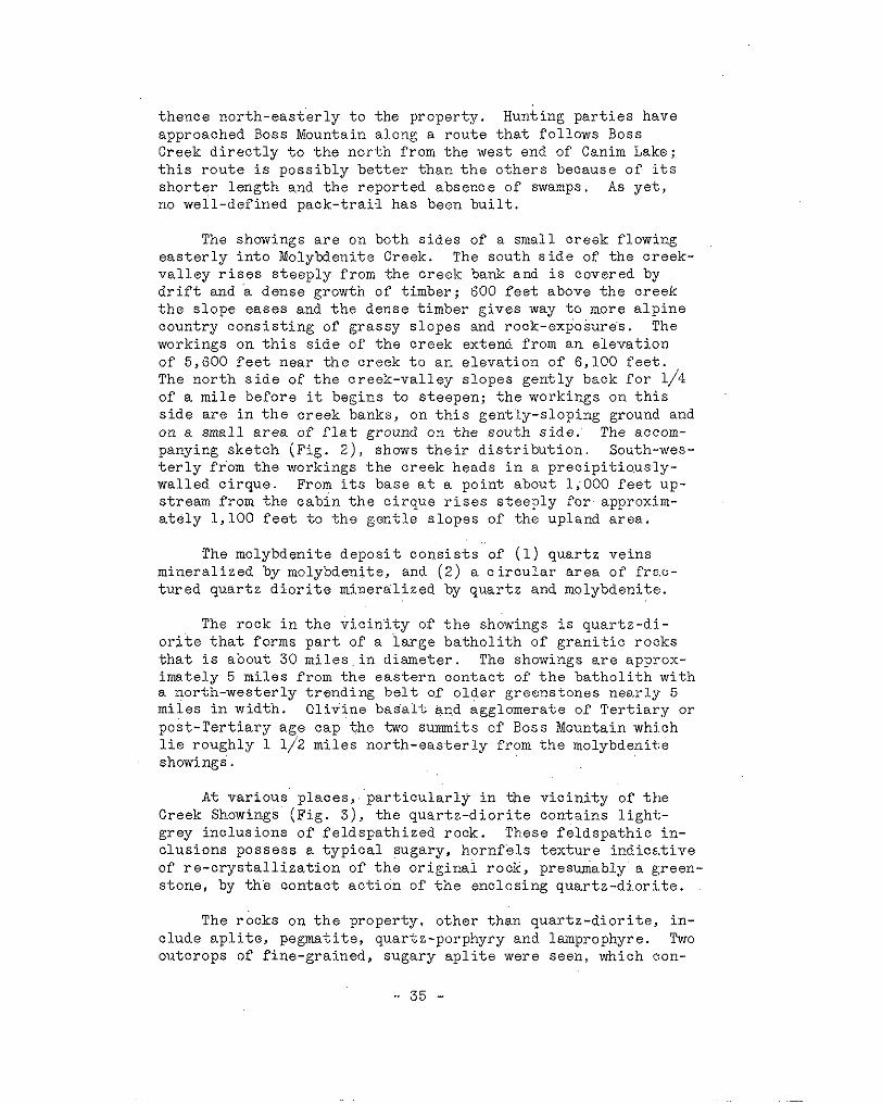
thence nor th-eas te r ly t o the property. Hunting parties have approached Boss Mountain along a rou te t ha t fo l lows Boss Creek d i r e c t l y t o t h e n o r t h from the west end of Canim Lake; t h i s r o u t e i s poss ib ly be t t e r t han t he o the r s because o f i t s sho r t e r l eng th and the reported absence of swamps. As y e t , no well-defined pack-trai-1 has been buil t .
The showings a r e on both sides of a small creek flowing easter ly into Molybdeni te Creek. The s o u t h s i d e of the c reek- v a l l e y r i s e s s t e e p l y f r o m t h e c r e e k bank and i s covered by
t h e s l o p e e a s e s and the dense t imber gives way t o more a l p i n e d r i f t and a dense growth of timber; 600 f e e t above the c r eek
count ry cons is t ing of grassy s lopes and rock-exposure's. The workings on t h i s s i d e of the creek extend f rom an e levat ion
The n o r t h s i d e of the c reek-va l ley s lopes gent ly back for 1/4 of 5,600 f e e t n e a r t h e c r e e k t o a n e l e v a t i o n o f 6,100 f e e t .
of a mile before it begins to s teepen; the workings on th i s s ide a r e i n t he c r eek banks , on t h i s gen t ly - s lop ing ground and on a small area of f l a t ground on the sou th side. The accom-
t e r l y fr'om the workings the c reek heads in a p r e c i p i t i o u s l y - panying sketch (Fig. Z ) , shows t h e i r d i s t r i b u t i o n . South-wes-
wal led c i rque. From i t s base a t a point about 1 ; O O O f e e t up-
a t e l y 1,100 f e e t t o t h e g e n t l e s l o p e s of the upland area. s t ream f rom the cab in the c i rque r i ses s teep ly for approxim-
The molybdeni te depos i t cons is t s of (1) quar tz ve ins mineral ized by molybdenite, and ( 2 ) a c i r c u l a r a r e a o f f ra .c- t u red qua r t z d io r i t e mine ra l i zed by qua r t z and molybdenite.
The r o c k i n t h e v i c i n i t y o f t h e showings i s quartz-di.- o r i t e t h a t forms p a r t of a i a r g e b a t h o l i t h o f g r a n i t i c roc:ks t h a t i s about 30 mi l e s i n d i ame te r . The showings are approx-
a no r th -wes te r ly t r end ing be l t o.f o lde r greens tones near ly 5 imately 5 m i l e s f r o m t h e e a s t e r n c o n t a c t o f t h e b a t h o l i t h w i t h
m i l e s i n width. O l iv ine basa l t and agglomerate of T e r t i a r y o r post-Tert iary age cap the two summits of Boss Mountain whj,ch l i e roughly 1 1/2 miles no r th -eas t e r ly from the molybdeni te showings.
A t va r ious p l aces , ' pa r t i cu la r ly i n the v i c i n i t y of t h e Creek Showings (P ig . 3) , t he qua r t z -d io r i t e con ta ins l i gh t - grey inclusions of fe ldspa th ized rock , These fe ldspa th ic in - c lus ions possess a typical sugary, hornfels texture indice. t ive of re -crys ta l l iza t ion of the o r ig ina l rock , p resumably a green- s tone , by the con tac t ac t ion o f the enc los ing quar tz -d ior i , t e .
The rocks on t he p rope r ty , o the r t han qua r t z -d io r i t e , i n - clude apli te, pegmatite, quartz-porphyry and lamprophyre. Two outcrops o f f ine-grained, sugary apli te were seen, which aon-
35 -
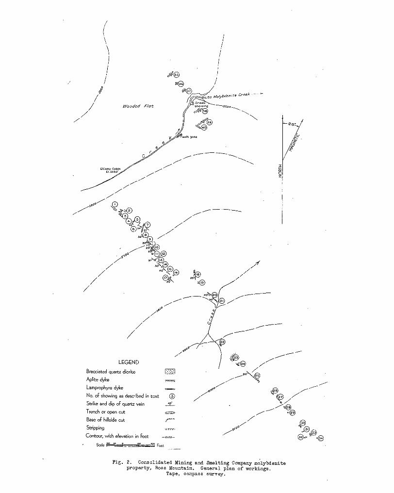
/ I
I I I
/ i / 4
/ Wooded Flat
/ /

No. 18 (Fig. 2 ) . Pegmati tes have been reported f rom the hi l l - s t i t u t e p a r t s of a dyke approximately 3 f e e t w i d e i n showir:g
s ide ly ing nor th-wes ter ly from t h e camp-cabin, but on the eouth-
f ind only small pegmati te veinlets of p ink or thoc lase and q,uartz. e a s t e r l y s i d e and i n t h e Creek Showings t h e w r i t e r was able: t o
Oneyquarter of a mile dorm-strem f rom the Creek Showings, a 4- f o o t dyke of quartz-porphyry, s t r iking south-easter ly and dipping 40 degrees south-westward, occurs on t he sou th s ide of the Creek.
hornbleride and b io t i t e were s een on t h e s o u t h - e a s t e r l y h i l l - P a r t s of a dark-green, lamprophyre dyke, consisting of
h i l l t o ?To. 31, and f o r most of t h e d i s t a n c e on t he no r th -eas t s ide ; it extends to the south-eas t of showing No. 2 2 up t h e
wa l l of a qua r t z ve in ; t he maximum width observed was 5 f e e t . Al though the patchy dis t r ibut ion of t he dyke as s e e n i n t h e cu ts a long the s t r ike , sugges ts tha t the l amprophyre occurL: a s i nc lus ions i n t he qua r t z -d io r i t e , t he p re sence of off-shoots of t h e lamprophyre from t h e main mass i n t o t h e q u a r t z - d i o r i . t e po in t s t o a somewhat l a t e r a g e . I t i s sugges ted tha t (1) the dyke may have been emplaced a t a l a t e s t a g e i n t h e c r y s t a l 1 . i - za . t ion and intrusion of t h e b a t h o l i t h , and a t a t i m e b e f o r e a l l movement of t h e magma had ceased, o r t h a t ( 2 ) the dyke may have f i l l e d g a s h - f r a c t u r e s i n t h e q u a r t z - d i o r i t e a f t e r a l l c r y s t a l - l i z a t i o n had ceased and the mass had become s o l i d .
The molybdenite occurrences on t he p rope r ty be long t o two
v e i n s t h a t f i l l t ens ion - f r ac tu res and t h e o t h e r a quartz-di- c l o s e l y - a l l i e d s t r u c t u r a l t y p e s . One t y p e c o n s i s t s of quar tz
o r i t e b r e c c i a cemented by quartz and molybdenite; molybdenj.te occurs in both types.
a long the s t r ike . In wid th they range f rom a knife-edge t o
represents the longes t cont inuous ly-exposed sec t ion of any one 2 1/2 f e e t and i n l e n g t h from 3 t o 56 f e e t ; this l a s t f i g u r e
ve in seen . I t i s possible that d isconnected exposures a l igned between showings ?lo. 23 and 32 (Fig. 2) over a length of 250 f e e t , r e p r e s e n t p a r t s o f t h e same v e i n . The g rea t e r number
no r th 50 degrees west , t h e l a t t e r s t r i k e be ing the preva len t of t h e ve ins r ange i n s t r i k e from nor th 70 degrees w e s t t o
one, and r a n g e i n d i p f r o m 25 degrees t o 80 degrees south- westward. The exposures and probably by f a r t h e g r e a t e r num- ber of veins , occur within a b e l t 150 f e e t i n w i d t h t h a t t r e n d s t o t h e s o u t h - e a s t u p t h e h i l l s i d e f o r approximately 2,000 f e e t f r o m t h e camp-cabin (Fig. 2 ) .
The qua r t z ve ins a r e va r i ab le i n w id th and discont inuous
In most of t he ve ins , mass ive qua r t z i s t h e main vein-. f i l l i n g . However, i n some v e i n s , p a r t i c u l a r l y a l o n g t h e i r borders , angular inc lus ions of wal l rock are abundant ; these
- 37 -

LEGEND
Massive quartz diorite c? Area in quartz diorite, marked by an abundance of basic inclusions
Area of abundant molybdenite in brecciated quartz diorite
Base of rock cut face - Top of creek bank 7rr,.N: ,,‘V
Fault, marked by gouge, crushed rock and ore ?Ivv\IyvL
Joints in quartz diorite @A Scale 20 40
”_ Feet
Sample No. Width % MoSZ I 2
Grab 2.7 Good grade breccia f r o m ore dump 56” 3.0 Across seams of MoS, and quart3
3 4
56“ 3-4 Solid breccia 3.4 seams of MoS, and yellow oxide 30” 3.5 I n n o r t h p o r t i o n of faul t 30ne, abundant MoS2 and yellow oxide
Descr ip t ion .
5 72” 2.0 C r u s h e d f a u l t 30ne mater ia l , rock, MoS2 and yellow oxide 6 70” 2.4 Across solid breccia, minerali3ed by MoS,
Fig. 3. Consolidated Mining and Smelting Company molybienite property, Boss Xountain. Detail of creek showings.
Tape, compass survey..

prophyre dykes occur they may be fragments of t h e dyke. A i n c l u s i o n s a r e mostly qua r t z -d io r i t e , bu t i n a r e a s where law
r i b b o n - t e x t u r e i n t h e v e i n - q u a r t z o c c u r s i n p a r t s of showing No. 25; th i s t e x t u r e i s cha rac t e r i s ed by t h i n films of f i n e - g ra ined mo lybden i t e i n pa ra l l e l f i s su res t ha t t hemse lves pa ra l - l e l . t he ' s t r i ke of t he ve in . The zones of such r ibbon-texture a re d i scon t inuous a long t he s t r i ke and probably represent an i n c i p i e n t p a r a l l e l f r a c t u r i n g of t h e v e i n r a t h e r t h a n marked shear ing wi th in it.
Quartz-dior i te , conspicuously brecciated and the f rag- ments sealed by quartz and abundant molybdeni te , (Plate I1 8 ) occurs wi th in an a rea 20 f e e t i n d i a n e t e r i n t h e Creek Show- ings (F ig . 3 ) . The brecciat ion extends north-wester ly and south-westerly for a d i s t ance , a s exposed in t renches , of 350 f e e t , b u t t h e i n t e n s i t y of t he b recc ia t ion i s much decreased and t h e amount of mol.ybdenite small. The breocia fragments a re ve ry angu la r i n outline and range from l /2 an i nch t o 6 inches i n maximum dimensions.
The area of intense brecciat ion presumably forms the c e n t r a l p a r t o f an ore-chimney or breccia-pipe. I t would, t he re fo re , be expec ted t o ex t end f a r the r ve r t i ca l ly t han ho r -
a c t e r i s t i c f r a c t u r i n g of a breccia-pipe i s considered to have i z o n t a l l y . Where no s t r u c t u r a l r e a s o n is ev iden t , t he char-
r e s u l t e d f rom the exp los ion o f water vapour and other vapours c o l l e c t i n g a t cer ta in po in ts under increas ing pressure dur ing the coo l ing and c r y s t a l l i z a t i o n of a bathol i th . Breccia-pipes have been wide ly d i scussed in l i t e ra ture , the m o s t recent des- c r ip t ions be ing t hose by M o n s (1935, 1938) and Perry (1933) (see Bibliography a t end of B u l l e t i n ) .
quartz . Molybdeni te occurs in varying amounts f rom t races to The f i l l i n g of b o t h t h e v e i n s a n d t h e b r e c c i a i s c h i e f l y
a s much as 3 .5 per cen t . , as shown by t h e accompanying assays.
normal t o t h e w a l l s of a v e i n o r t o t h e o u t l i n e s o f included The molybdenite commonly occurs 8 s films of blades arranged
rock-fragments; the films range from 1/32 t o 1 1 2 an inch in wid th ; l ess commonly it o c c u r s a s t h i n r i b b o n s ' o f v e r y f i n e - grained molybdenite imparting a r ibbon- t ex tu re t o t he ve in , as i n showing No. 25. The canary-yellow oxidation product, the hydrated ferr ic molybdate , molybdi te , i s common on t he su r f ace of t h e v e i n s o r i n the shear-zones of t h e Creek Showing. A
veins and the brecc ia . Occas iona l c rys ta l s o f p ink or thoclase, small amount of chalcopyr i te and py r i t e occu r s i n b o t h t h e
ranging from l/S t o 1/2 a n i n c h i n s i z e o c c u r i n b o t h t h e v e i n s and breccia; these are a lways associated with the molybdeni te e i t h e r on t he bo rde r s o f t h e v e i n s o r surrounding rock-frag- ments , ind ica t ing tha t they formed ea r ly i n t he s equence of
- 39 -

minera l iza t ion . The mine ra l r e l a t ions sugges t t ha t a consid-
p o s i t i o n o f both t h e o r t h o c l a s e and molybdenite: The occur- e r ab le amount of vein-quartz formed subsequent ly to the de-
rence o f small amounts of ' o r thoc la se sugges t s t he c lose a f - f i n i t y of t he ve in -ma t t e r i n bo th t he qua r t z ve ins and b recc ia to pegmat i tes , and i t s format ion represents a s t a g e i n s e p a r - a t i o n of v o l a t i l e s from t h e magma chamber immediately succeed- ing the pegmat i te s tage .
i n g t o t h e way it has allowed for t h e emplacement of (1) a p l i t e i n f r a c t u r e s o f t w o d i rec t ions , no r th snd no r th -eas t e r ly ; (2 ) a lamprophyre dyke i n a no r t in -wes te r ly s t r i k ing f r ac tu re f (3) t h e q u a r t z a s v e i n s i n d i s c o n t i n u o u s f r a c t u r e s s t r i k i n g p r e - dominantly north-westerly and dipping south-westward; (4) quar tz as cementing material f o r t he b recc ia t ed qua r t z -d io r i t e
has been no shear ing, and t h i s condi t ion , combined w i t h t h e of t h e Creek Showing. I n t h e s e p re -mine ra l f r ac tu re s t he re
c h a r a c t e r i s t i c b r e c c i a t i o n of t h e w a l l r o c k , i n d i c a t e s t h a t the p re-minera l f rac tures a re s imple t ens ion- f rac tures , as op- posed t o t h e s h e a r s .
Frac tur ing of t h e q u a r t z - d i o r i t e may be grouped accord-
abundant crushed rock and gouge, which i s evidence of a con- The pos t -minera l fau l t s o r shea r s a r e cha rac t e r i s ed by
s i d e r a b l e amount of shear ing wi th in the f rac ture-zones . ' Faul t s
Two s m a l l f a u l t s w e r e s e e n i n t h e a d i t o r showing No: 10 o r shea r s a r e no t common i n t h e v i c i n i t y of t h e q u a r t z v e i n s .
c i a o f t h e Creek Showing. Most of the shear ing i s confined t o fig^ 2 ) . Pos t -minera l shear ing has been in tense in the b rec-
two eas t -wes te r ly s t r i k ing zones of crushed rock and gouge ranging from 1 f o o t t o 4 f e e t i n w i d t h . A wide faul t -zone s t r i k i n g n o r t h 60 deg rees ea s t and 5 f e e t i n w i d t h , . c u t s t h e q u a r t z - d i o r i t e on t he sou th -eas t e rn s ide of the creek approx- imately 250 feet up-st ream from the Creek Showing (?ig. 3 ) .
The f i r s t record of molybdenite on Boss (Big Timothy) Mountain i s i n t h e Annual Xeport Min.ister of Mines, B r i t i s h Columbia, f o r 1917, p. 134, which s t a t e s ,
"During 1917 exposures of molybdenite were discovered by Ryan and claims were s taked covering them."
During the. following year development work was done by Ryan and Hamilton. Apparently l i t t l e was done between then and 1930, when the p rope r ty was bonded by the Consol idated Mining and Smelting Company and a considerable amount of work done on t h e t r a i l . S i n c e t h e n f a r t h e r s u r f a c e e x p l o r a t i o n h a s been carr ied on by t h i s company.
- 40 -

and s t r i p p i n g s and one s h o r t a d i t ; t h e i r d i s t r i b u t i o n i s shown on Pig. ( 2 ) . Caved cu t s , o r t h o s e showing no rock , a r e no t
one , those up the h i l l s ide south-eas te r1 .y ' f rom' the camp-cabin shown on Fig . ( 2 ) . The workings w i l l be desc r ibed i n two groups,
and those on t h e banks of the c reek nor th-eas te r , ly down-stream from the cab in , known a s t h e Creek Showing.
The workings on the property comprise numerous open-cuts
No: 1 cut has been driven south 55 degrees ea s t fo r 20 f e e t t h r o u g h d i s i n t e g r a t e d q u a r t z - d i o r i t e . Two l enses of quartz are exposed, one, on the south-wes ter ly wal l , t h a t measures 1 f o o t ' b y 3 f e e t , and the other in the back a t t h e face measuring. a few inches by 3 f e e t . None o f t h e s e show
d e n i t e were seen on t h e dump. any molybdenite, al though fragments of quar tz conta in ing molyb-
No.. 2 i s a shal low c u t t h a t has been driven south 75 de- g rees ea s t f o r 1 2 f ee t t h rough qua r t z -d io r i t e . The cut exposes a r e l a t i v e l y f l a t q u a r t z v e i n on the nor th w a l l , t ha t r anges
molybdenite o c both wal l s . from 2 t o 3 inches i n t h i ckness , and conta ins a t h i n s h e e t of
No. 3 cut has been driven south 55 degrees eas t for 16
minera l ized wi th a small amount of molybdenite on the north- f e e t . From 10 f e e t t o t h e f ace , a l e n t i c u l a r v e i n of quar tz
e a s t e r l y w a l l , o u t c r o p s i n t h e f l o o r ' ; t h i s v e i n i s v e r t i c a l
a t t h e t o p of t h e c u t . The rock on the wes t w a l l o f t he ve in m d ranges from 8 i n c h e s i n w i d t h a t t h e f l o o r t o 18 inches
i s q u a r t z - d i o r i t e and on the eas t wal l . it i s p a r t of a green- s tone i nc lus ion .
No. 4 i s a s t r ipp ing tha t has been dr iven south 65 degrees
curving qua r t z l ens 5 f e e t long by a f e w inches w i d e t h a t e a s t f o r 2 0 f e e t . The f l o o r on t h e southern end exposes a
pinches out on both Ads. I t s t r i k e s s o u t h - e a s t e r l y and d i p s 45 degrees south-westward'; and contains 9. l i t t l e molybdenite on the hanging-wall .
d iameter tha t exposes an a rea o f quar tz -d ior i te inc lus ions in No. 5 i s an i r r egu la r s t r i pp ing approx ima te ly 10 f ee t i n
vein-quartz , 5 f e e t i n diameter, and on t h e w e s t w a l l a 2-imch
wide on both wal ls over a length of 2 f e e t . The molybdenit? s t r i n g e r of qua r t z t ha t has a r ibbon of molybdenite 1,/2 an inch
c r y s t a l s are conspicuously normal t o t h e walls of t h e s t r i n g e r .
s i d e ' t h a t e x p o s e s a n a r e a of b r e c c i a t e d q u a r t z - d i o r i t e s e a h d No. 6 i s a square s t r ipp ing approximate ly 10 f e e t on the
and c u t by ve in-quar tz ; the t w o main quar tz l enses o f t h i s show- ing s t r ike no r th -wes te r ly and no r th -eas t e r ly . Only one small '
- 41 -

f i l m o f molybdenite was s e e n i n t h i s m a t e r i a l .
e a s t f o r 60 f e e t i n q u a r t z - d i o r i t e . Twelve f e e t from t h e nor thern end a ba r ren qua r t z ve in ou tc rop s t r ikes no r th 55 degrees west and dips 25 degrees south-westward.
No;. 7 i s a t rench tha t has been dr iven nor th 15 degrees
No. 8 i s a sma l l s ideh i l l cu t t ha t exposes a lens of
west and dipping 50 degrees south-westward; the lens contains qua r t z 3 f e e t t h i c k by 4 f ee t l ong , s t r i k ing no r th 15 deg re . e s
only a l i t t l e molybdenite.
No. 9 i s a s i d e h i l l s t r i p p i n g w i t h i t s l o n g a x i s s t r i k - ing south 45 d e g r e e s e a s t f o r a length of 2 1 f e e t . A s t r o n g bu t ba r r en qua r t z ve in 1 2 inches wide, exposed on t h e n o r t h - e a s t e r l y s i d e o f t h e s t r i p p i n g , s t r i k e s n o r t h 70 degrees west and d.ips 10 degrees south-westward. Westerly from this vein the re a r e two . sma l1 a r eas o f b recc i a t ed qua r t z -d io r i t e s ea l ed by quartz , but containing no molybdenite.
The open-cut has been driven south 10 degrees wes t for 15 fee t , No. 10 working i s a combined open-cut and short adi t .
and south 40 degrees west f o r 1 4 f e e t t o t h e p o r t a l of t h e a d i t ; t h e a d i t h a s been d r iven sou th 40 degrees wes t for 14 fee t to t h e f a c e . For 7 f e e t o u t f r o m t h e p o r t a l of t h e a d i t t h e open-
th ree qua r t z -ve ins , s t r i k ing no r th 50 degrees west and dipping o u t i n t e r s e c t s a zone of quartz-veins. This zone contains
20 degrees south-westward, that range'from 2 t o 1 2 i n c h e s i n wid th ; severa l smal le r para l le l s t r ingers occur be tween these main veins . Discont inuous f r inges of molybdenite occur on the walls of these quartz-veins. Occasional narrow veins o r crushed
ment a long t he veins . A f l a t f a u l t n e a r t h e f a c e of t h e a d i t rock i nd ica t e t h a t t h e r e has been a s l i gh t pos t -mine ra l move-
has d i sp laced the ve ins 3 f e e t t o t h e w e s t .
Close t o t h e b o t t o m i n t h e n o r t h - w e s t e r l y w a l l of t h i s s h a f t t h e r e i s a l ens of ba r ren qua r t z , 8 f e e t l o n g by 2 f e e t t h i c k ,
westward. The s o u t h ' w a l l of t h e s h a f t i s marked by c lose ly - s t r ik ing no r th 40 deg rees wes t and dipping 30 degrees south-
s p a c e d j o i n t s i n t h e q u a r t z - d i o r i t e t h a t s t r i k e n o r t h - e a s t e r l y and d i p 80 degrees. south-eastward.
No. 11 working i s an o ld shaft 5 f e e t w i d e by 8 f ee t deep .
No. 12 i s a cu t tha t has been dr iven south 50 degrees ' eas t f o r 11 f e e t . The f ace o f t he cu t exposes a qua r t z l ens 28 inches t h i ck which s t r ikes no r th 50 deg rees wes t and dips 55 degrees south-westward. The l ens con ta ins a ' f ew small f r ag - ments o f q u a r t z - d i o r i t e i n the hanging-wall; each fragment i s bounded . b y a fr inge of molybdeni te . A sample taken across 28
- 42 -

inches assayed: Molybdenite, 6.0 per cent .
No: 13 i s a r ec t angu la r s t r i pp ing 10 f e e t by 15 f e e t tha t exposes a 9-foot length of a qua r t z l ens 2 t o 3 f e e t t h i c k , t h a t s t r i k e s n o r t h 45 degrees west and dips 50 degrees south-westward. Numerous angular inc lus ions of qua r t z -d io r i t e occur in t he hang ing-wa l l of t h e l e n s . A few small quartz l e n s e s c u t t h e q u a r t z - d i o r i t e 5 f e e t w e s t of t h e main l ens . There i s v e r y l i t t l e m o l y b d e n i t e i n t h i s showing, and t h e m.a- t e r i a l i n a p i l e on t h e n o r t h - e a s t e r l y s i d e of t h e s t r i p p i r g , c o n t a i n s b u t l i t t l e ' m o l y b d e n i t e .
o f qua r t z 5 f e e t w i d e 'by 6 f e e t l o n g tha t s t r i k e s s o u t h 50 de- g r e e s e a s t a n d d i p s 40 degrees south-westward. This quartz. l ens conta ins numerous angular inclusions o f q u a r t z - d i o r i t e that a r e f r i n g e d by molybdeni te c rys ta l s growing normal t o t h e
by numerous blade-l ike gashes t h a t i n d i o a t e t h e l o c a t i o n of' ,
f a c i e s of the f ragments . The su r face of t h e qua r t z i s mark:ed
blades of molybdenite which have weathered. A sample taken across. 5 f e e t of vein-matter and i n c l u d i n g f i v e 1/2-inch f r i n g e s of molybdenite, 'assayed: Molybdenite, 6 . 0 per cent:. A sample taken'from an ore-dump t h a t e v i d e n t l y r e p r e s e n t e d hand-sorted materials assayed: Molybdenite, 8 . 6 per cent .
No. 14 i s a s t r i p p i n g 1 0 f e e t s q u a r e t h a t e x p o s e s a lens
No. 15 i s a s t r i p p i n g 8 f e e t by 1 5 f e e t t h a t e x p o s e s a t r iangular ly-shaped quar tz l ens 6 fee t long by 1 foot wide , t h a t i s ' a p p a r e n t l y a cont inua t ion of t h e q u a r t z i n t h e l a s t s t r i pp ing ; t h i s l ens con ta ins on ly a few f l a k e s of molybdenite.
Showing No. 16 comprises two very shor t t renches each of which contains a s h o r t s t r i n g e r of quar tz conta in ing very l i t t l e molybdenite.
, . No. 17 i s a s i d e h i l l s t r i p p i n g 36 f e e t l o n g t h a t exposes
two quartz-veins ranging f r o m 6 t o 18 i nches i n t h i ckness t ha t
They a r e b o r d e r e d i n p a r t by 1/4-inch fringes o f molybdenite. s t r i ke no r th 50 deg ree ' s wes t and d i p 30 degrees south-westward.
The rock i s qua r t z -d io r i t e .
No. 18 is a c u t 10 f ee t 1ong . tha t exposes a 2- inch quartz v e i n , s t r i k e n o r t h d i p 35 degrees wes t , wi th 1/4 t o l/2-inch f r i n g e s of molybdenite on i t s wa l l s . I t l i e s i n a 3-foot a p l i t e dyke of s i m i l a r a t t i t u d e a n d s t r i k e .
h i l l s i d e f o r 1 5 f e e t . A sho r t l ens of qua r t z , 2 f ee t l ong by No. 19 i s a c u t t h a t has been dr iven souther ly in to the
6 inches wide , occurs c lose to the face ; it contains a small amount of molybdenite. Fragments of a p l i t e i n q u a r t z - d i o r i t e
- 43 -
were seen in both walls of t h e c u t .
badly s loughed, but exposes par t of a 12-inch quartz lens t h a t s t r i k e s n o r t h 50 degrees west and dips 40 degrees south- westward; t he qua r t z con ta ins a small amount o f molybdenite.
No. 2 0 cu t , d r iven sou th 65 d e g r e e s w e s t . f o r 1 5 f e e t ,
No. 2 1 i s a s i d e h i l l s t r i p p i n g t h a t e x t e n d s 24 f e e t north-wester ly f rom the west bank of a small creek. I t ex- poses a quartz-vein 3 t o 6 i n c h e s i n w i d t h t h a t s t r i k e s n o r t h 50 degrees west and dips 30 degrees south-westward. The v e i n c u t s ' q u a r t z - d i o r i t e and a 6 - f o o t v e r t i c a l a p l i t e d y k e t h a t s t r i k e s n o r t h 5 5 d e g r e e s e a s t .
No. 22 i s a short cut , a lmost completely s loughed, but
consis t ing a lmost wholly o f hornblende and biot i te . it exposes part 'of f ine-grained, dark-green, lamprophyre dyke
No. 23 i s a s i d e h i l l s t r i p p i n g and cut that exposes on i t s south-wester ly face a 9-foot length of qua r t z , 15 inches
showing. A 5-foot width of the dark-green, lamprophyre dyke in t h i ckness t ha t s t r i kes no r th -wes te r1 .y . No molybdenite was
exposed i n No. 22 l i e s o n ' t h e e a s t s i d e o f t he ve in ; e l s ewhere the rock is qua r t z -d io r i t e .
.No. 24 i s a l s o a s i d e h i l l s t r i p p i n g and cut that exposes what i s pro'bably t h e e x t e n s i o n of t he qua r t z ve in f rom No. 23;
molybdenite. A 3-foot width of the green, lamprophyre dyke i s he re t he qua r t z i s 12 . inches w ide , and con ta ins ve ry l i t t l e
exposed a d j a c e n t t o t h e e a s t s i d e of t h e v e i n .
No. 25 i s a s t r i p p i n g t h a t e x t e n d s f o r 56 f ee t sou th -
a qua r t z -ve in t ha t r anges f rom 8 i n c h e s t o 2 1/2 f e e t i n w i d t h , e a s t e r l y u p t h e h i l l s i d e and exposes a cont inuous sect ion of
s t r i k e s n o r t h 45 degrees west and d ips 80 degrees south-west- ward. The foo t -wa l l pa r t of t h e v e i n i s ribboned by t h i n films of very f ine-gra ined molybdeni te ; e l sewhere the quar tz i s mass- ive . In gene ra l , t he mo lybden i t e i n t h i s ve in i s f ine r -g ra ined than that seen elsewhere on t h e h i l l s i d e . The vein, occurr ing as an e l eva ted r i b , i s t h e o n l y m a t e r i a l e x p o s e d i n t h e s t r i p - ping, except f o r some inc lus ions of the lamprophyre dyke and qua r t z -d io r i t e ; t he p re sence o f t hese i nc lus ions i nd ica t e t ha t t h e v e i n i s l a t e r t han t he l amprophyre dyke. The.following samples were taken across the vein: one across the full 2 1/2- foot width of v e i n a t a p lace 25 f ee t f rom the no r th end , a s -
p lace across 6 inches of high-grade mater ia l in the ' hanging- sayed: Molybdenite, 1 . 3 pe r cen t . , and another f rom the same
w a l l assayed: Molybdenite, 2, .5 per cent, ; a t h i r d sample t a k e n a c r o s s t h e f u l l 2 1/2-foot width of t h e q u a r t z v e i n a t
- 44 -
a po in t 8 feet f rom the south end, assayed: Molybdeni te , 1 .4 per cen t .
No. 26 i s a s i d e h i l l c u t and s t r i p p i n g t h a t exposes only q u a r t z - d i o r i t e and thin patches of the green dyke on t h e wes- t e r l y w a l l .
d io r i t e and pa t ches of green dyke, bu t no vein-matter . No. 27 i s a s imi la r cu t and s t r ipp ing expos ing quar tz - .
no vein-matter. , The qua r t z -d io r i t e con ta ins a few hornfela No. 28 i s a sho r t cu t t ha t exposes qua r t z -d io r i t e , bu t
i nc lus ions and i n one p lace i s c u t by a 1 - inch ve in l e t of epi - dote .
No. 29 i s a s t r i p p i n g 1 2 f ee t l ong t ha t exposes a v e r t i - c a l q u a r t z l e n s 1 foo t w ide t ha t s t r i kes no r th 37 deg rees wes t ; t he qua r t z con ta ins a l i t t l e f i n e - g r a i n e d m o l y b d e n i t e and paper- t h i n i n c l u s i o n s of the green dyke.
lamprophyre dyke, here 1 foot wide. No. 30 i s a sho r t t r ench t ha t exposes on ly t he g reen
No. 31 i s a shor t t rench expos ing on ly quar tz -d ior i te .
No. 32 i s a shor t t r ench expos ing qua r t z -d io r i t e and E; s t r i n g e r of qua r t z 1 inch t h i ck .
No. 33 i s a sho r t t r ench expos ing qua r t z -d io r i t e and E~
p a r t of green lamprophyre dyke 1 foo t t h i ck ; o f f shoo t s of t h e dyke were seen t o e x t e n d i n t o t h e q u a r t z - d i o r i t e .
No. 34 i s a s h o r t t r e n c h tha t exposes on ly quar tz -d ior i te .
The b e s t showing o f molybdenite i s t h e one known as t h e Creek Showing (Fig. 3) , approximately 800 f e e t down-stream from t h e camp-cabin. In an a rea approximate ly 20 f e e t i n d i a m e t e r o n t h e e a s t bank of t h e c r e e k ( P i g . 3 ) , t h e q u a r t z - d i o r i t e h a s been in tense ly b recc ia ted and the f ragments sea led by molyb- den i t e , o r thoc la se and q u a r t z ( P l a t e I1 B ) . This mineral ieed breccia has been cut by pos t -minera l fau l t s , the fau l t -zones being marked by crushed rock and mineral mat ter ; much of t h e molybden i t e i n t he c rush zones has a l t e r ed t o t he cana ry - yel low, hydrated ferr ic molybdate , molybdi te . The quar tz -
numerous fe ldspa thes ized greenstone inc lus ions : t h e s e a r e j,n d i o r i t e here and t o t h e nor th across the creek-bed containa
va r ious s t ages o f absorp t ion o r f e l d s p a t h i z a t i o n by t h e q u m t z - d i o r i t e and as a r e s u l t r a n g e i n c o l o u r from dark-grey t o EL l ight-grey, which i s o n l y s l i g h t l y d i f f e r e n t from t h e g e n e r a l
- 45 -

colour of t h e main rock-mass.
The molybdenite occurs mainly as rims surrounding rock- f ragments (Plate I1 B ) . Less f requent ly it occurs i n t h e
den i t e ve in l e t s cu t t i ng t he rock mass . In t h e ground exposed, quartz forming the matr ix f o r t h e b r e c c i a o r i n quartz-molyb-
t h e b e s t development of molybdenite i s c o n f i n e d t o t h e 20- f o o t a r e a of i n t ense b recc ia t ion which i s shown by t h e a r e a sampled i n F i g . ( 3 ) . Only small amounts of molybdenite occur t o t h e n o r t h a c r o s s t h e c r e e k or in t h e t r e n c h e s t h a t l i e north-wester ly and south-easter ly f romthe Creek Showing. I t i s p robab le t ha t t he a r ea or most in tense b recc ia t ion cons t i - t u t e s t h e c e n t r a l p a r t o f a brecc ia -p ipe , and , therefore , has a v e r t i c a l e x t e n t g r e a t e r t h a n i ts hor i zon ta l .
i n age and as such have no causa l r e l a t i o n t o t h e emplacement The f a u l t s and accompanying fau l t -zones a r e post-mineral
of the molybdeni te . The quartz-molybdeni te solut ions probably rose t h rough t he b recc ia t ed qua r t z -d io r i t e , the b recc ia t ed f r ag - ments inducing precipi ta t ion of the molybdenite and o r thoc la se a s i s ind ica t ed by the f requent occur rence of molybdenite and o r t h o c l a s e a s rims around the rock-fragments . The grade of t h e o r e i n t h e Creek Showing is shown by t h e t a b l e of assays or1 Fig. ( 3 ) .
v i c i n i t y o f t h e Creek Showing, b u t s o far have f a i l e d t o un-
d e n i t e s i m i l a r i n amount t o t h a t found on t h e e a s t e r n s i d e of cove r an a r ea o f b recc i a t ed qua r t z -d io r i t e con ta in ing molyb-
t h e c r e e k i n t h e Creek Showing.
Trenches have been dug on both s ides of t he c r eek i n t h e
Showing No. 35 i s a t rench 45 fee t long expos ing a zone o f b recc ia 10 f e e t w i d e i n q u a r t z - d i o r i t e . The b r e c c i a t i o n i n t h i s zone has been s l ight and the amount of qua r t z and molybdenite i s correspondingly small .
s l i g h t l y b r e c c i a t e d zone approximately 20 f e e t w i d e , t h e Showing No. 36 is a t r e n c h 20 feet long, exposing a
south-westerly 5 f e e t of which contains numerous v e i n l e t s of quar tz ; on ly a l i t t l e molybdenite occurs here.
t h i s t r e n c h i s badly weathered, but it a p p e a r s t o be s l i g h t l y b recc ia t ed ; qua r t z occu r s a s ve in l e t s and i r r egu la r a r eas i n
A s axp le t aken ac ross 3 f e e t a t the no r th -eas t end of t h e the b recc ia . Nei ther molybdeni te nor molybdi te are abundant .
trench assayed: Molybdenite; 0 .3 per cent . and one a c r o s s 3 f e e t a t t h e s o u t h - w e s t end assayed: Molybdenite, 0 .2 per cent .
Showing No. 37 i s a t r e n c h 3 0 f e e t l o n g . The r o c k i n
- 46 -

Showing No. 38 i s a t rench SO feet long which exposes a breccia zone approximately 2 0 f e e t wide, the fragments of which a re s ea l ed by quar tz and a l i t t l e m o l y b d e n i t e .
No. 39 i s a t r e n c h EO f ee t l ong . The q u a r t z - d i o r i t e j.n th i s t rench conta ins an abundance o f bas ic inc lus ions in vary- ing s tages of absorp t ion . The assemblage i s c u t by quartz-. v e i n l e t s , and i n one place, by a pegmat i te ve in le t 1/2 an inch wide. Very l i t t l e molybdeni te occurs in th i s t rench .
o r i t e c u t b y q u a r t z v e i n l e t s , and l a t e o r t h o c l a s e s t r i n g e r s . No. 40 i s a t r ench 40 f ee t l ong t ha t exposes qua r t z d i -
No molybdenite was seen here .
I t is repor ted (!Wilmot, 1935, p. 49) t h a t t h e p r o d u c t i o n to da t e has cons i s t ed of 1 ,000 pounds of picked ore from which 350 l b s . of molybdenite was recovered. There has been no pro- duc t ion i n r ecen t yea r s .
The Creek Showing of fers the bes t chance f o r t h e deve:top- ment of an ore-body. In support of t h i s s t a t e m e n t , t h e w r i t e r s u g g e s t s t h a t t h e a r e a of i n t e n s e b r e c c i a t i o n i n t h i s showing may f o r m t h e c e n t r a l p a r t of an ore-chimney or brecc ia-p ipe . The work done ' to date ' l (July, 1937) i s a l l su r face work and a s such does not supply data which may a i d i n d e t e r m i n i n g e i t h e r
ists, what i t s conf igura t ion i s with depth. The pipe may in- (1) whether such a p i p e e x i s t s or not , or ( 2 ) , if t he p ipe ex-
crease, decrease, or remain constant in diameter with depth.
As an a id i n de t e rmin ing t he s t ruc tu re , d i amond-d r i l l i ng i s suggested as t h e b e s t t y p e of fu tu re , p re l imina ry exp1o:ra- tory work. Several 45-degree holes directed radial ly towards t h e c e n t r e of t h e a r e a of i n t ense b recc ia t ion would give de- terminat ive information.
BENTHAM MOLYBDENITE Nos. 1 t o 8 mineral claims staked i n PROSPECT. (30) 1937 by T . Bentham, and owned by
This prospect consis ts of t h e M-oll~
-
e r , B. C . The w r i t e r examined t h i s p r o s p e c t i n September, 1939.
Bentham and a s s o c i a t e s of Powell :?iv-
The showings a r e on the no r th -wes t s ide .o f Raslam Lake,
Lake may be reached from t h e toym of Powell River by fol low- a small lake ly ing about 6 m i l e s e a s t o f Powell Lake. Haslam
ing the Cranberry Lake road south-eas te r ly f o r 2 .6 miles and thence by a branch road t o t h e e a s t f o r 1 . 5 m i l e s t o a boat- landing a t the sou th end of Haslan Lake. From here a boat may be taken f o r 2 mi l e s t o t h e camp-cabin on the north-west shore of t h e l a k e .
The showings a r e s c a t t e r e d a l o n g t h e h i l l s i d e between
e leva t ions of' 430 f e e t and 1150 f e e t above Haslam Lake.
The m i n e r a l i z a t i o n c o n s i s t s of small amounts of molyb- den i t e i n s ca t t e r ed occu r rences of (1) a p l i t e or f ine-grained g ran i t e dykes , (2 ) qua r t z - f i l l ed j o in t s r ang ing f rom 1\16 of an . i nch t o 1 1/2 inches wide, and (3) quartz veins ranging from 4 t o 18 inches wide. Assays o f the samples taken ranged
d i o r i t e . from: Molybdenite, - n i l t o 0 .2 per cent . The rock i s quar tz -
The main working i s an ad i t 430 f ee t above the l ake and ap- proximately 1,600 f ee t wes t e r ly f rom the cab in . The working has been dr iven nor ther ly as an open-cut 15 fee twide for 9 f e e t , t h e n a s a n a d i t 10 f e e t h i g h f o r 1 2 feet . This develop- ment c u t s t h r e e a p l i t e o r f ine-gra ined gran i te dykes in quar tz - d i o r i t e . The dykes s t r i k e n o r t h 4 0 d e g r e e s e a s t , d i p 60 de- grees north-westward and range from 4 t o 18 inches wide. k small amount of molybdenite occurs a s 1/8 t o 1/4 of a n i n c h f l a k e s a s s o c i a t e d with pegmati t ic quartz and fe ldspar on t h e footwal l - s ide of t h e l a r g e s t a p l i t e dyke. Two selected samples of the best mater ia l assayed: Molybdeni te , &.
A t a point 520 feet above the lake and about 900 f e e t south-easter ly a long t h e h i l l s i d e f r o m t h e a d i t , a s t r i p p i n g
45 f e e t . The bottom o r sou the rn pa r t of t h e c u t was covered 15 f e e t wide extends i n a d i rec t ion nor th 15 degrees wes t f o r
by sloughed overburden a t the t ime of t he wr i t e r ' s examina t ion (September, 1939). No minera l i za t ion was s e e n i n t h e exposed p a r t , b u t t h e dump showed a considerable amount or" mate r i a l
wide that contained molybdenTte and cha lcopyr i te . Severa l of cons i s t ing of qua r t z s t r i nge r s f rom 112 an i nch t o 2 inches
t h e s e s t r i n g e r s a r e r e p o r t e d t o o c c u r in t h e lower p a r t of t h e s t r i p p i n g . '
t h e last s t r i p p i n g and approximately 500 feet above the lake,
west f o r 35 f ee t . Th i s s t r i pp ing r anged i n w id th f rom 10 t o a second s t r ipp ing ex tends in a d i r ec t ion no r th 15 deg rees
l e t s o c c u p y i n g j o i n t s i n t h e q u a r t z - d i o r i t e . These v e i n l e t s 15 f e e t . The mine ra l i za t ion cons i s t s of numerous qua r t z ve in -
generally range from 1/16 of an i nch t o 1 1/2 i nches i n w id th ; one 4-inch vein was seen. In the %-foot l ength of s t r i p p i n g 65 veinlets were seen, spaced f rom 4 inches t o 2 f e e t a p a r t . They contain quartz and small amounts of molybdenite and chal- copyrite. Seven chip-samples taken over consecutive 5-foot
t o 0.2 pe r cen t . sect ions a long the s t r ipping assayed f rom: Molybdeni te , - n i l
k t a p o i n t 8 0 f e e t s o u t h - w e s t e r l y a l o n g t h e h i l l s i d e from
A t a po in t 100 fee t south-wes ter ly from t h e las t s t r i p -
- 4 s -

ping, a quartz vein has been exposed f o r 25 f e e t . This v e i n
from 2 t o 6 inches, and contains a small amount of molybdenite i s ve r t i ca l , s t r i kes no r th 50 deg rees ea s t , r anges i n w id th
and cha lcopyr i te .
open-cutting has been done on a v e r t i c a l s h e a r t h a t s t r i k e s Thi r ty f e e t above and due west from t h e a d i t , a l i t t l e
no r th 45 degrees eas t . The shear i s 1 foot wide and consi.sts of shea red , ch lo r i t i c qua r t z -d io r i t e t ha t con ta ins a small amount of disseminated chalcopyri te and green carbonate. I t contains nei ther quartz nor molybdeni te .
A* a po in t no r the r ly f r o m and 160 fee t above the ad i t ; , a small c u t 2 by 5 f e e t w i t h a IO-foot face, has been made on an 8-inch wide a p l i t e dyke t h a t s t r i k e s n o r t h 5 0 d e g r e e s o a s t and d ips 75 degrees north-westward. The dyke contains on1.y a v e r y l i t t l e m o l y b d e n i t e .
a cu t 10 fee t l ong by 2 fee t wide by 2 feet deep has been made on a quartz vein f rom 6 t o 1 2 inches wide tha t s t r ikes no] - th 50 degrees east and dips 75 degrees north-westward. The min- e r a l i z a t i o n c o n s i s t s of a small amount of magnet i te , molybden- i t e and yellow molybdic ochre.
A t a point nor ther ly f rom and 350 f e e t above t h e a d i t ,
Ap l i t e , o r f i ne -g ra ined g ran i t e dykes cu t t he qua r t z - d i o r i t e a t var ious p laces on t h e h i l l s i d e between t h e a d i t and a bench approximately 700 f e e t above. These dykes, s t r i k e nor th-eas te r ly , d ip s teep ly nor th-wes tward , range in wid th
molybdenite i n p a p e r - t h i n seams. from 1 2 t o 18 inches, and i n p laces conta in a small amoun-c o f
I n 1937, t h e writer 'examined JFRVIS INLET - MT. 'NELLINGTON MOLYBDENITE the sou th -eas t e r ly s lopes (of
an occurrence of molybdenite on
PROSPECT, ( 38 ) M t . Wellington, a mountain op- pos i t e or south-westerly f:rom
t h e mouth of Pr incess Louisa In le t , near the head of J e r v i s I n l e t . The occurrence i s ha l f a mile south-west from t h e south-west end o f a lake, about 2 miles l o n g , t h a t i s approx-
w r i t e r examined t h i s prospect i n September, 1937. imately 3 miles from and 2,800 f e e t above tidewater' . The
son's Logging Camp, where a launch may be obtained; thence by Access i s by Union Steamship up Je rv is In le t to Gus taf -
launch f o r 10 m i l e s t o t h e mouth of a smal l c reek tha t f lows
poin t oppos i te the mouth of Princess Louisa I n l e t . From t h e in to Queen ' s Reach of J e r v i s I n l e t from the south-west, a t a
beach, access i s by an o ld logging inc l ine or skid-way t h a t
- 49 -

extends up a v e r y s t e e p s l o p e w e s t e r l y t o q po in t 2400 f e e t
wes t e r ly for approximately 2 m i l e s t o t h e n o r t h - e a s t end of above t h e l a k e ; t h e n c e . @ a poor ly def ined ' foo t - t ra i l south-
a small lake 2800 f e e t above t idewater . From t h i s end of t h e
t o t h e o t h e r end of t he l ake . From here, a f o o t - t r a i l l e a d s lake a l o g r a f t i s used t o t r a v e l , &'or approximately 2 miles ,
south-wester ly for half a m i l e t o t h e bottom of a l a r g e t a l u s s lope t ha t ex t ends upwards t o t h e b a s e of unsoalable rock b l u f f s .
occu r s i n t a lu s f r agmen t s a s 1/8-inch f l a k e s i n c l u s t e r s t h a t range from 2 i n c h e s t o 4 i n c h e s i n d i a m e t e r s c a t t e r e d i n qua r t z -d io r i t e , and a s s imi l a r f l akes a s soc ia t ed w i th 2 - inch c l o t s of pegmat i t i c qua r t z , f e ldspa r and mica, widely scattered i n t h e q u a r t z - d i o r i t e . The occurrence of the molybdenite i s no t con t ro l l ed by any recognizable s t ruc ture . Many of t h e ta lus-boulders conta in numerous r u s t s p o t s t h a t a r e t h e r e s u l t of ox ida t ion of g r a i n s of p y r r h o t i t e and p y r i t e .
There a r e no workings on the p roper ty . The molybdenite
Although two samples, taken across two indiv idua l c lus - ters , .assayed: Molybdeni te , 2 .6 per cent . and 2 . 7 pe r cen t . ,
mining i n t h e a g g r e g a t e ; t h e d i s t a n c e s b e t w e e n c l u s t e r s r a n g e r e s p e c t i v e l y , t h e s e c l u s t e r s a r e t o o w i d e l y s p a c e d t o p e r m i t
from 1 f o o t t o s e v e r a l f e e t .
An occurrence of molybdenite on Gray Creek
This i s an old discovery and i s considered
was staked between 1916 and 1919 by Axel, Chas. 0. and Swan. A. t o be t h e same one described by Wilmot (1925, p. 31), which
per iod. h a n s o n . The underground work was probably done during that
GRAY CREEK (49) was examined by the wr i t e r i n j une 1938 .
The property i s reached from Gray Crdek pos t -of f ice , on t h e e a s t s i d e of Ilootenay Lake, by fo l lowing a r o a d e a s t e r l y for 1 1/2 m i l e s t o Magee's farm, and then by fo l lowing an o ld , overgrown road f o r t h ree -qua r t e r s of a m i l e t o t h e o n l y a c c e s s - i b l e working, a l o n g d r i f t - a d i t .
The ground i n t h e immediate v i c i n i t y of t h e a d i t i s covered by dense bush and the hi l ls ide r ises s teeply above the a d i t i n a no r th -eas t e r ly d i r ec t ion .
The a d i t h a s been dr iven north 62 degrees eas t f o r 57 f e e t , n o r t h 56 d e g r e e s e a s t for 40 f e e t , n o r t h 62 degrees ea s t fo r 67 f e e t , and no r th 48 degrees ea s t for 11 f e e t t o t h e f a c e . Throuzhout i t s l eng th it fol lows a v e r t i c a l q u a r t z v e i n t h a t maintains a f a i r ly un i fo rm wid th of 3 f e e t . lnlith t h e excep-
- 50 -

t i o n of a 4 - foo t ap l i t e dyke , t he rock i s massive grani te . The a p l i t e dyke i s v e r t i c a l and s t r i k e s a c r o s s t h e a d i t i n a d i r ec t ion no r th 45 deg rees ea s t a t a po in t 135 fee t in from t h e p o r t a l .
masses of p y r i t e , c l u s t e r s of muscovite and a small amount of molybdenite. The loca t ion , wid th and a s says of samples f r o m those s ec t ions of t he v e i n showing most molybdenite, a r e as fo l lows . No. 1, 4 0 f e e t from t h e p o r t a l , a c r o s s 3 f e e t of vein-matter containing a considerable amount of p y r i t e and some molybdenite: Gold, trace; si lver, 0.2 ounces per ton: molybdenite, 0.04 per cent. No,. 2 , 75 f e e t from t h e porta11
but no p y r i t e : Gold, n i l ; s i l v e r , I&; molybdenite, 0.3 per ac ross 3 .5 f ee t of vein-matter containing some molybdenite
cent .
The ve in-mat te r cons is t s of abundant quartz , scat tered
-
LITTLE KEEN PROPERTY. c o n s i s t s of t h e L i t t l e Keen, L0S.t The Sapples molybdenite property
(50) Chance and Lucky Jim mineral claims
Sapples of Salmo. The property was examined by t h e w r i t e r i n June 1938.
s t a k e d i n 1932 and owned by Jack
c l o s e t o i t s junc t ion wi th Sheep Creek. The a c t u a l showings a r e 500'. above the Sheep Creek road and about half a mi l e
road from Salmo by fo l lowink the Salmo-Nelway highway for souther ly f rom the road. The proper ty may be reached by m3tor-
4 1/4 mi l e s sou the r ly f r o m Salmo, t hen t u rn ing t o t h e east and fo l lowing the Sheep Creek road f o r 3 3/4 m i l e s t o t h e camp at Bennet t Creek.
This property i s on t he wes t s ide of Bennett (Bear) Creek
n o r t h - e a s t e r l y i n t o B e n n e t t C r e e k a n d p a r t l y t o t h e n o r t h i n t o Sheep Creek. The h i l l s i d e was seve re ly burned over several years ago and i s now covered by doiun-timber and brush.
The showings a r e on a s t e e p h i l l s i d e , p a r t of which slopes
in t he fo l lowing quo ta t ion : The general geology i s descr ibed by Walker (1934, p. 8 6 )
"Molybdenite occurs in, and c l o s e t o t h e c o n t a c t o f , ap l i t i c g ran i t e w i th s ed imen t s of t he Pend-d '0 re i l l e .
0. E. LeRoy i n t h e e x p l a n a t o r y n o t e s o n . t h e s k e t c h map s e r i e s . T h i s i s presumably the occurrence mentioned by
of Sheep Creek mining camp.
contact between grani te a n d s t r a t a of t h e Pend-d '0 re i l l e "Several cuts and s t r i p p i n g s expose a north-dipping
- 51 -

contac t and l o c a l l y i s a l t e r e d , t h e a l t e r a t i o n b e i n g s e r i e s . The g r a n i t e i s f ine-grained a n d a p l i t i c a t the
cha rac t e r i zed by t h e development of greenish whi te t a l c w i t h which molybdenite appears t o be a s soc ia t ed . The g r a n i t e i s v e r y r i c h i n q u a r t z , a b o u t 30 per cen t , and t h e f e l d s p a r i s o r thoc la se o r mic roc l ine w i th a r e l a t i v e l y small amount of p lag ioc la se . The a r g i l -
a mass of pyroxene, amphibole, c a l c i t e , and t i t a n i t e . laceous sediments a t t h e c o n t a c t a r e h i g h l y a l t e r e d t o
The i n t e n s i t y of a l t e r a t i o n r a p i d l y d i m i n i s h e s array from the contact . The l imestone band i s i n p a r t i n - tense ly a l te red and ho lds abundant brown garnet and t remoli te , considerable molybdeni te , and a l i t t l e p y r r - h o t i t e . The less a l tered l imestone has been given a greepish co lour .
ments for a f e w inches away from t h e c o n t a c t , and a l s o a l o n g f r a c t u r e s f o r 1 foo t or 2 f e e t from t h e c o n t a c t . The most nor ther ly cu t exposes a l tered sediments, and l imes tone cu t by granite tongues. Molybdenite occurs i n a n a r r o w , v e r t i c a l f i s s u r e s t r i k i n g 40 degrees and a l so a long j o in t p l anes i n t he l imes tone .
"Disseminated molybdeni te occurs in the sedi-
"It i s ev iden t t ha t t he mo lybden i t e i s c l o s e l y a s s o c i a t e d w i t h t h e g r a n i t e c o n t a c t and o c c u r s e i t h e r i n t he g ran i t e o r t he enc los ing s ed imen t s fo r sho r t d i s t ances on e i t h e r s i d e of t h e c o n t a c t . "
The workings, consis t ing of a shor t ad i t , open-cuts and ' s t r i pp ings , a r e desc r ibed below:
The p o s i t i o n of the workings w i l l be g i v e n i n r e s p e c t o f .the s i n g l e s h o r t a d i t which i s about 500 f e e t above the Sheep Creek road.
35-degree s lope f r o m t h e sho r t ad i t , an open-cut, 8 f ee t w ide , Prom a po in t 80 f e e t n o r t h - e a s t e r l y down t h e h i l l on a
has been driven f o r 1 2 f e e t i n a d i r e c t i o n s o u t h 25 degrees west . The face exposes a gran i te -sed iment contac t tha t ranges i n s t r i k e f r o m s o u t h 2 0 deg rees wes t t o sou th 10 degrees ea s t and d i p s 45 degrees wes tward: the g ran i te l i es und.er t h e s e d i - ments on t h e s o u t h - e a s t e r l y s i d e of t he con tac t . A l though t he s t r i k e of the contao t i s l o c a l l y v e r y i r r e g u l a r , it can appar- en t ly be t raced up the h i l l s ide to the south toward . the ad i t and nearby workings. No molybdenite was seen i n t h i s work ing .
i n a d i r e c t i o n s o u t h 25 degrees wes t for 10 f e e t t o t h e p o r t a l ; The a d i t (as of June 1938) begins as an open-cut dr iven
- 52 -
from h e r e t h e a d i t e x t e n d s i n t h e same d i r e c t i o n for 5 f e e t t o t h e f a c e . The nor th wa1.l of t he work ing cons i s t s of gran- i t e and the south w a l l of se'diments. Small amounts of molyb- d e n i t e o c c u r a t t h e c o n t a c t and in t h e g r a n i t e f o r 3 f e e t from t h e c o n t a c t . h sample along 2.8 f e e t of what appeared t o be t h e b e s t g r a d e of ma te r i a l from the contac t assayed: Molyb- deni te 1 .5 per cen t . Two samples of mineral ized grani te mar the con tac t t aken ac ross 2 .9 f e e t and 1.6 fee t assayed respec- t ively; Molybdeni te 0.9 and 0.3 per cent. In t h i s working the sed imen t s con ta in ve ry l i t t l e mo lybden i t e .
From a p o i n t 1.8 f e e t i n a d i r e c t i o n n o r t h 70 degrees west from the nou th of t h e l as t open-cut, a deep open-cut extends
f ace ; t h i s work ing seems t o be the o ldes t on the p rope r ty . i n a d i rec t ion south 25 degrees west f o r 1 7 f e e t t o a rock-
t h a t have been largely replaced by bands of t h e l i m e - . s i l i c a t e The rock i n t h i s c u t c o n s i s t s of p h y l l i t e and limy sediments
ments s t r i k e n o r t h 45 degrees west md dip 35 degrees north- minerals diopside, brown ga rne t , and wo l l a s ton i t e . The sed i -
ga rne t band about 4 f e e t t h i c k on the south-eas t wall a t a eastward. I n th i s cu t mo lybden i t e occu r s i n a 4-foot diopside-
po in t 12 f e e t back from t he f ace . A sample taken across i-t assayed: Molybdenite 0.5 pe r cen t . I t i s i n t e r e s t i n g t o n o t e t h a t t h e s e d i m e n t s in t h e f a c e of t h i s work ing a r e cu t by an 8 - inch , ap l i t e s i l l . T h i s a p l i t e i s i n p a r t r e p l a c e d by p e g m a t i t i c q u a r t z a n d t h e l a t t e r by brown ga rne t .
From t h e mouth of t h e a d i t o p e n - c u t , a s t r ipping exte:nds south-eas te r ly f o r 45 fee t . This exposes on ly g ran i te .
From the sou th -eas t end of this s t r i p p i n g a c ross - t rench extends south-westerly f o r 15 f e e t t o a combined s t r i p p i n g and open-cut that extends 15 f e e t s o u t h - e a s t e r l y ' a n d 25 f e e t n o r t h - westerly. This working exposes a con tac t between g r a n i t e on t h e n o r t h - e a s t and sediments on the south-wes t ; the contac t appea r s t o s t r i ke no r ' t h 70 degrees west and d i p 40 degrees.
con tac t ; No. 1, measures 6 f e e t by 6 inches and a sample across south-westward. Two l enses of molybdeni te occur a long this
it assayed: Molybdenite 3.9 per cent. ; No. 2 , measures 2 f e e t by 18 , inches and a sample across this assayed: Molybdeni te
amount of molybdenite was seen across a 2-foot width of s e d i - 0 .9 per cent . Tavards the upper or south-easter ly end a small
men t s c lo se t o t he con tac t ; a sample t aken across th i s assayed: Molybdenite 0.3 per cent.
The rock i n t h i s working consists of g r a n i t e t o t h e n o r t h - e a s t of t h e c o n t a c t and p h y l l i t e t o t h e s o u t h - w e s t . A sma.11 amount of d iops ide and ga rne t occu r s a long t he con tac t .
- 53 -

Several open-cuts have been dug t o t he sou th up t he h i l l s i d e f r o m t h e l a s t c u t . Although some of these expose a grani te-sediment contact , , none contain molybdeni te other t h a n i n t r a c e s .
bodies of commercial o r e . The showings a s of June 1938, do not show any mineable
MOLLY (52). the following Crown-granted claims: The Molly molybdeni te property consis ts of
and Molly Nos. 1 t o 9 i n c l u s i v e which a r e owned by the Consolidated Mining and-Smelting Company of Canada, Ltd. This property was examined by t h e w r i t e r i n June, 1938.
The proper ty , loca ted on Lost Creek i n t h e .Nelson Mining Divis ion, i s reached by leaving the Nelson-tielway Highway a t a point approximately 5 3/4 miles south of Salmo and follow-
e r f o r approximately 1 1/2 miles t o L o s t Creek, thence by a ing an o ld road t ha t goes up t he sou th fork of t h e Salmo Riv-
branch road north-easterly up Lost Creek f o r 2 3/4 mi l e s t o the old camp-si te that i s half -a-mile t o th.e.vrest of t h e mouth of a no r the r ly - f lowing t r i bu ta ry of Lost Creek. A t t h e t ime of t h e w r i t e r ' s v i s i t ( J u n e , 1 9 3 8 ) , it, was imposs ib l e t o take a ca r more t h a n 1 1/2 mi les u p t h e r o a d .
mately 600 feet above the creek-bot tom on a s t eep no r the r ly - s l o p i n g h i l l s i d e .
The workings are on the sou th s ide of Lost Creek approxi-
The general geology i s a s g iven i n t he fo l lowing ex t r ac t by J . F. Walker (1934, p. 85) :
of g ran i te ex tending f o r 4 miles along Lost Creek. The edge, of t h e g r a n i t e body a t t h e Molly runs a l i t t l e e a s t of south up t h e h i l l t o a n e l e v a t i o n of 4 ,000 fee t , where it t u r n s e a s t and fol lows t h i s d i r -
sumes i t s south course . To the wes t sed iments%rgi l - e c t i o n f o r a l i t t l e ove r 1 ,500 f ee t , t o where it r e -
gran ice ou tcrops wes te r ly for severa l hundred fee t , 1aceous)outcrop for about 1,200 fee t , beyond which
and up t h e h i l l s i d e , t o e l e v a t i o n s of 3 , 6 0 0 . f e e t t o 3 , 7 0 0 f e e t .
"The proper ty i s on t h e w e s t end of a l a r g e a r e a
"The g r a n i t e i s j o i n t e d o r sheeted more o r l e s s p a r a l l e l t o t h e con tac t w i th t he s ed imen t s . The molyb-
* ( inser t ion by S tevenson)
- 54 -

m o s t l y i n a sheeted zone having a maximum observed width deni te occurs i n t h e g r a n i t e c l o s e t o t h e c o n t a c t and
of 1 0 f e e t . The sheeted zone s t r i k e s from 15 de-
t e r l y t o v e r t i c a l . The bes t minera l iza t ion appears g r e e s t o 25 degrees, and dips from 40 degrees wes-
t o be a t a po in t where the contac t d ips at low angles
body. The nor ther ly ex tens ion of t h e b e s t m i n e r a l i - a s if t h i s po in t were nea r t he t op of t h e g r a n i t e
za t ion appears t o have been eroded away. A l i t t l e molybdenite can be seen disseminated throughout ' the g r a n i t e i n t h e single, s h o r t a d i t .
"The most favourable ground appears t o be along t h e c o n t a c t ( i n t o t h e h i l l - s i d e ) s o u t h from and about a t t h e l e v e l of the open-cuts . Some diamond d r i l l -
a r e unknown t o t h e w r i t e r . i n g h a s b e e n d o n e i n t h i s d i r e c t i o n , b u t t h e r e s u l t s
"Four thin sect ions were c u t from specimens taken across 3 f e e t of t he shee ted zone holding average g rade minera l iza t ion . One sec t ion ho lds on ly t r a c e s of molybdenite. In t h e o t h e r t h r e e s e c t i o n s p y r r h o t i t e i s the predominating sulphide and i s accom- panied by chalcopyri te , molybdeni te , and p y r i t e . A l - most a l l t h e m o l y b d e n i t e i s in te rgrown wi th pyr rhot i te
many a r e smaller . The mine ra l i za t ion a p p e a r s t o be i n g r a i n s few of which a r e l a r g e r t h a n 0.05 nun. and
l a t e r t h a n t h e g r a n i t e . M o l y b d e n i t e i s ' p l a s t e red a l o n g some of t h e j o i n t p l a n e s i n t h e s h e e t e d ' z o n e , and forms a small percentage o f , the h igh-grade o re ."
The workings, which consist of one shor t ad i t and s eve ra l open-cuts, are descr ibed i n de t a i l below.
The a d i t has been dr iven in a d i r e c t i o n s o u t h 45 degrees e a s t f o r 58 f e e t t o t h e f a c e . A t a po in t 50 fee t f rom the p o r t a l a cross-working has been driven in a d i r ec t ion sou th 35 degrees west f o r approximately 45 f e e t . From a point 15 f e e t back f rom the face of t h i s c ros s work ing , a r a i s e con- n e c t s w i t h a deep open-cut approximately SO f e e t above. Five f e e t n o r t h - e a s t e r l y f r o m t h e r a i s e a working has been driven t o t h e w e s t f o r 5 f e e t w h e r e a la rge winze now f i l l e d w i t h water and of unknown depth has been sunk. The on ly s t ruc tu re i n t h e ad i t i s a 4- foot sec t ion of s h e e t i n g i n t h e south-west end of the cross-working; otherwise there i s only massive g r a n i t e . A few specks of molybdeni te were seen in the wal ls of t h i s a d i t . Eowever, it i s repor ted by Wilmot (1925, p. 37)
t h i s w inze . t h a t t h e b e s t o r e on the p rope r ty was found a t t he bo t tom of
- 55 -

The r a i s e f r o m the ad i t b reaks t h rough i n to t he floor of an open-out 1 2 f ee t deep and 8 f e e t w i d e t h a t e x t e n d s e a s t e r l y up t h e h i l l s i d e on a 30-degree slope f o r approximately 80 f e e t .
t h e g r a n i t e . T h i s zone has a minimum th ickness of 8 f e e t i n The whole cut i s wi th in the zone of wel l -def ined shee t ing in
t h e c u t . The component j o i n t - p l a n e s s t r i k e n o r t h 25 degrees
6 t o 18 i n c h e s a p a r t , a r e by no means pa ra l l e l , t hey cu rve e a s t and 45 degrees wes te r ly . The joint-planes, spaced f r o m
gradual ly in to each o ther and enclose masses of unf rac tured g r a n i t e . N e i t h e r t h e j o i n t - p l a n e s nor t h e i n t e r v e n i n g g r a n i t e i n t h i s c u t c a r r y much molybdenite.
Ten fee t no r th -eas t e r ly f rom the t op of t h e l a s t c u t , a small cut has been driven 4 f e e t i n a d i r e o t i o n n o r t h 75 de- g r e e s e a s t and 4 f e e t i n a d i r e c t i o n n o r t h 25 degrees ea s t . This cu t i s i n t h e same sheeted zone. Two samples taken across the shee t ing in th i s cu t assayed: Molybdeni te 0 .1 and 0.08 per cen t . respec t ive ly .
d i s t ance of 60 fee t nor th-eas te r ly f rom here . These indicate Severa l sha l low cu ts and s t r ipp ings have been made f o r a
tha t the zone of c lose ly spaced shee t ing d ies ou t no r th -eas t e r ly and a few small patches of' quar tz-feldspar pegmati te appear .
A s h o r t d i s t a n c e t o t h e s o u t h - e a s t u p t h e h i l l s i d e f r o m
been excavated along the contour of t h e h i l l s i d e for 75 f e e t the open-cut immediately over the ra ise , a large open-out has
i n a d i r e c t i o n n o r t h 30 degrees ea s t . A t the south-wes ter ly end of t h i s c u t s h e e t i n g i s well developed over a zone t h a t measu res 14 f ee t i n th i ckness . Ths j o i n t s , 4 inches apar t ,
n o r t h e r l y and d i p 35 degrees westward. Although the sheeted a r e more, c losely-spaced than i n t h e l o w e r c u t , and t h e y s t r i k e
zone contained more molybdeni te than any o ther par t of t h i s c u t , t h e amount was very small. h sample taken across i t s width assayed; Molybdenite 0.1 pe r cen t . To t he sou th -eas t up t h e h i l l from t h i s c u t , i n t h e f o o t - w a l l of t he shee ted -
patches of quartz-feldspar pegmati te were seen. zone, a s i n t h e c u t s n o r t h - e a s t e r l y from the main cu t , small
d r i l l i n g was done by the Consolidated Mining and Smelting Com- pany previous to 1934.
I t i s unders tood tha t a c o n s i d e r a b l e a m o k o f diamond-
Although no o r e was i n s i g h t a t the t ime of t h e w r i t e r ' s examina t ion , pas t r epor t s i nd ica t e t ha t a cons iderable ton- nage of high-grade mater ia l was mined and shipped, Descrip- t i o n s by Drysdale (1915, p. 254) and by W i l m o t (1925, p. 37) ind ica te tha t the o re mus t have come from the main open-out and r a i se connec t ing t he ad i t w i th t he open-ou t and , from t h e w i n z e i n t h e a d i t . The fol lowing i s the r eco rd of production, as given by W i l m o t (1925, p. 38):
- 56 -
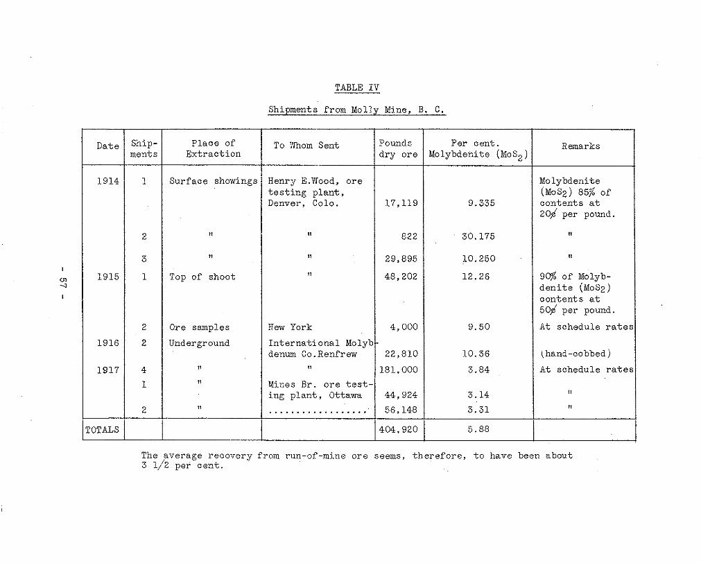
Dat -
191
191
191
191
- 1TAI -
~
Ship- nent s Ext rac t ion
Place of
Surface showings
I
, Top of shoot
Ore samples
Underground
TABLE I V
Shipments from Molly Mine, B. C.
To Xhom Sent
Henry E.Wood, o r e
Denver. Colo. t e s t i n g p l a n t ,
Xew York
I n t e r n a t i o n a l Moly' d e n m Co.Renfrew
Mines B r . ore t e s t i ng p l an t , Ottawa ..................
'0 und s lry ore
17,119
822
29,895
48,202
4,000
22,810
.81,000
44,924
56,148
L-04,920
Molybdehite (Nosz) Per cent .
9.335
30.175
10.250
12.26
9.50
10.36
3.84
3.14
3.31
5.88
Remarks
Molybdenite (MoSz) 85% of conten ts a t 20b per pound.
,, I1 I
9% of Molyb- d e n i t e (MoSz) conten ts a t 50,d per pound.
A t s chedu le r a t e s
(hand-cobbed)
At schedule rates
The average recovery from run-of-mine ore seems, therefore, t o have been about 3 1/2 per cent .

MRGARET GROUP ( 6 2 ) mineral c la ims, the Margaret , The Margaret group consis ts of s i x
William, David Fred and Jean, staked
couver. The w r i t e r examined t h i s proper ty i n September, 1937. i n 1936 and owned by 0. A . !Woolsey of 4329 Kinney S t r e e t , Van-
The property i s 1 2 miles north-westerly from the head of P i t t Lake. I t i s reached from P i t t Lake by f o l l o w i n g P i t t River up-stream f o r 3 miles a long an old motor-road, then c ross ing t he P i t t R i v e r t o t h e w e s t s i d e i n a rowboat; thence by good pack-horse t r a i l for 9 m i l e s t o t h e camp and workings a t an e leva t ion of 1800 f e e t .
The shoTvings a r e between elevations of 1650 feet and 1850 f e e t , on Boise Creek t h a t f l o w s s o u t h - e a s t e r l y i n t o P i t t R i v e r , joining it approximately 4 miles above the head of P i t t Lake.
near i t s junc t ion w i th a smll south-wester ly f lowing creek The most important showings are along the banks of Boise Creek
tha t j o ins Bo i se Creek frdm t h e e a s t a t a n e l e v a t i o n of 1670
thi .s branch creek and isolated showings in other more remote fee t . Severa l l ess impor tan t showings occur a long the bed of
branch creeks.
I n t h e immediate v i c i n i t y of t h e showings, Boise Creek
t imbered. In many places sloughing along the creek banks f lows i n a V-shaped v a l l e y , t h e h i l l s i d e s of which a r e h e a v i l y
branch-creek f lows through a rocky canyon a.nd over a rocky exposes bed-rock and the molybdenite showings. The main
f l o o r t o Boise Creek.
o r i t e t h a t i n c l u d e s many l a r g e and small inc lus ions o f f i n e The rock formation of t h e immediate area i s quar tz -d i -
d io r i t e , andes i t i c g reens tone and remnants of feldspar-porphyry dykes
br id mix ture of q u a r t z - d i o r i t e and d i o r i t e i s conspicuously In t h e v i c i n i t y of t h e main molybdenite showings, t h e hy-
sheeted by c lose ly - space3 j o in t s ; however, t h e s e do not appear t o have in f luenced the loca l iza t ion of the molybdeni te . On t h e o the r hand, it i s t o be noted that the most abundant molybden- i t e o c c u r s i n a n a r e a w h e r e t h e amount of diori te conspicuous- l y exceeds the quar tz -d ior i te , whereas quar tz -d ior i te wi th very
t h e main molybdenite occurrences, contains only widely scat- l i t t l e d i o r i t e , common a t d i s t a n c e s o f 500 f e e t or more from
t e r e d f l a k e s of molybdenite.
t y p e s . F i r s t and mos t impor t an t , a r e s t r i nge r s and c l u s t e r s of m o l y b d e n i t e f l a k e s i n s i l i c i f i e d c r u s h - z o n e s t h a t a r e up t o
The molybdeni te occurrences on the property are of two
- 58 -

3 fee t wide ; and second, scat tered segregat ions i n c lean-cut qua r t z -py r i t e ve ins t ha t r ange from 1/2 an i nch t o 12 inches wide. O f t h e s e two types , t he f i r s t i s t h e more important.
the on ly ad i t which has been dr iven on the south-wes t s ide of Boise Creek, opposi te the junct ion of t h i s c r e e k , a t 1670 f e e t e levat ion, wi th the branch-creek as above descr ibed.
The main occurrence of molybdenite i s a t t h e p o r t a l o f
This adi t has been dr iven i n a d i r ec t ion sou th 25 de- g r e e s e a s t f o r 25 f e e t . Most' oP the molybdeni te occurs in an i n d e f i n i t e zone tha t r anges Prom 2 t o 3 f e e t w i d e ; and s t r i k e s nor th-eas te r ly . This zone cons ' is ts of l eached and s i l i c i f i ed
, i t e and quartz-pyri te molybdeni te veinlets which range from 1 w a l l - r o c k t h a t c o n t a i n s s c a t t e r e d c l u s t e r s OP Plake-molybden-
inch to 3 inches wide.
Three samples t aken across th i s zone assayed as fo l lows . Across 12 inches a t a p lace 6 f e e t in f rom the por ta l ; Molyb- den i t e , 0.72 per cent ; i ron, 8 .5 per cent . Across 28 inches a t t h e p o r t a l : M o l y b d e n i t e 0.36 per cen t . ; i ron , 4 .6 per cent . Across 14 inches a t a po in t 3 f e e t o u t from t he po r t a l : Molybdenite, 1.26 p e r ' c e n t . ; i r o n , 5.7 per cent .
Immediately t o t h e n o r t h and north-east across Boise
molybdenite showings. One cu t , i s loca ted 75 feet i n a d i r e c - Creek f r o m t h e a d i t , two small cuts have been dug on two l ean
t i o n n o r t h 45 d e g r e e s e a s t f r o m t h e a d i t , and has been driven 3 f e e t n o r t h - e a s t e r l y ; t h e o t h e r c u t 8 f e e t above, i s 30 f e e t north-westerly up-stream from the lower, aad has been driven 8 f e e t i n a d i r e c t i o n n o r t h 20 degrees eas t .
and pyr i te , averaging 2 inches wide, t h a t occur i n a 5-fooi; wide leached zone i n , t h e q u a r t z - d i o r i t e ; t h i s zone contain:! a small amount of disseminated molybdenite. The upper cut ex- poses a f l a t ve in , 4 inches wide, containing quartz , pyr i te and a small amount of molybdenite.
T h e lower cut exposes three i r r egu la r , gash ' i e in s of quartz
A small cut has been dr iven 3 f e e t n o r t h - w e s t e r l y i n t o t h e bank o f a small branch creek, a t a p l a c e 1 5 0 f e e t i n a d i r e c t i o n n o r t h 70 degrees west up-stream f r o m t h e l as t upper
ranges f r o m 4 t o 8 f ee t w ide and' conta ins fou r 4-inch vein:; cu t . Th i s cu t has ' been d r iven on a l en t i cu la r c rush -zone t ha t
of qua r t z , py r i t e and a l i t t l e m o l y b d e n i t e .
Several widely spaced quartz-molybdenite veins occur :in t h e bed of the branch creek that , jo ins Boise Creek direct ly ac ross from t h e a d i t . These w i l l be described consecutive:ly
- 59 -

up-s t ream towards the fa l l s .
Number 1 i s a 4-inch wide quartz-molybdenite vein-outcrop- ping in the e a s t bank 50 feet above the creek bed, 230 f e e t up- stream from Boise Creek. A sample taken across this assayed: Molybdenite, 0 .9 pe r cen t . ; and i ron , 5.0 per cen t .
Number 2 , a 4- inch wide quartz-pyri te vein i n t h e bed of the c reek and 240 feet up-stream from 3oise Creek, contains only a l i t t l e molybdenite.
w ide qua r t z ve in t ha t con ta ins t he most abundant molybdenite of any of the occur rences on t h e p r o p e r t y . A 12 - inch smple across this assayed: Molybdeni te , 2 .52 per cent . ; and i ron, 1 . 9 per cent ,
Number 3, 40 feet up-stream from number (2) i s a 12-inch
Number 4, 70 feet up-stream from number ( 3 ) i s an 8-inch wide qua r t z -py r i t e ve in w i th ve ry l i t t l e molybdenite.
qua r t z -py r i t e ve in . Xumber 5 , 30 feet up-stream from 4, i s a 3-inch wide
Number 6, 70 feet up-st ream from number ( 5 ) , i s a zone
but conta in ing only a l i t t l e molybdenite. A 10-inch sample of c o n t a i n i n g s i x , 4- inch wide veins of quartz and heavy.pyr i te ,
t h i s a s sayed : Mo1ybdenite;nil; and iron, 9.4 per cent.
In the rock b luf fs immedia te ly below t h e f a l l s of a creek that f lows south-easter ly into Boise Creek 1500 feet up-st ream from t h e a d i t , t h e r e a r e a few quartz-pyrite-molybdenite s t r i n g e r s i n t h e m a s s i v e d i o r i t e .
Four hundred f e e t down Boise Creek from the adit , an 8 -
the creek on a 10- inch wide f rac ture zone tha t conta ins pyr i te , foo t cu t has been dr iven nor th-eas te r ly in to the eas t bank of
quar tz , b roken d ior i te and a l i t t l e s c a t t e r e d m o l y b d e n i t e .
At an e leva t ion of 1840 f ee t on both banks of a creek, that f lows north-easter ly into Boise Creek and joins it approx-
c rushed and l eached zone i n t he qua r t z -d io r i t e t ha t ca r r i e s imately 1000 feet down-stream from the adi t , there i s a wide
a t i o n of open-cutting and sloughing of the stream-banks has ex- s c a t t e r e d and varying amounts of molybdenite. Here, a combin-
posed two main crush-zones, one down-stream, 1 2 inches wide and one up-stream, 1 2 f e e t w ide ; t he s t r i ke of both zones i s i n d e f i n i t e , b u t , is appa ren t ly sou th -eas t e r ly ac ross t he c r eek . A samole taken across the 12-inch wide zone assayed: Molyb- deni te , 0 .72 per cent ; i ron, 5 .4 per cent . A 6-foot sample
- 60 -
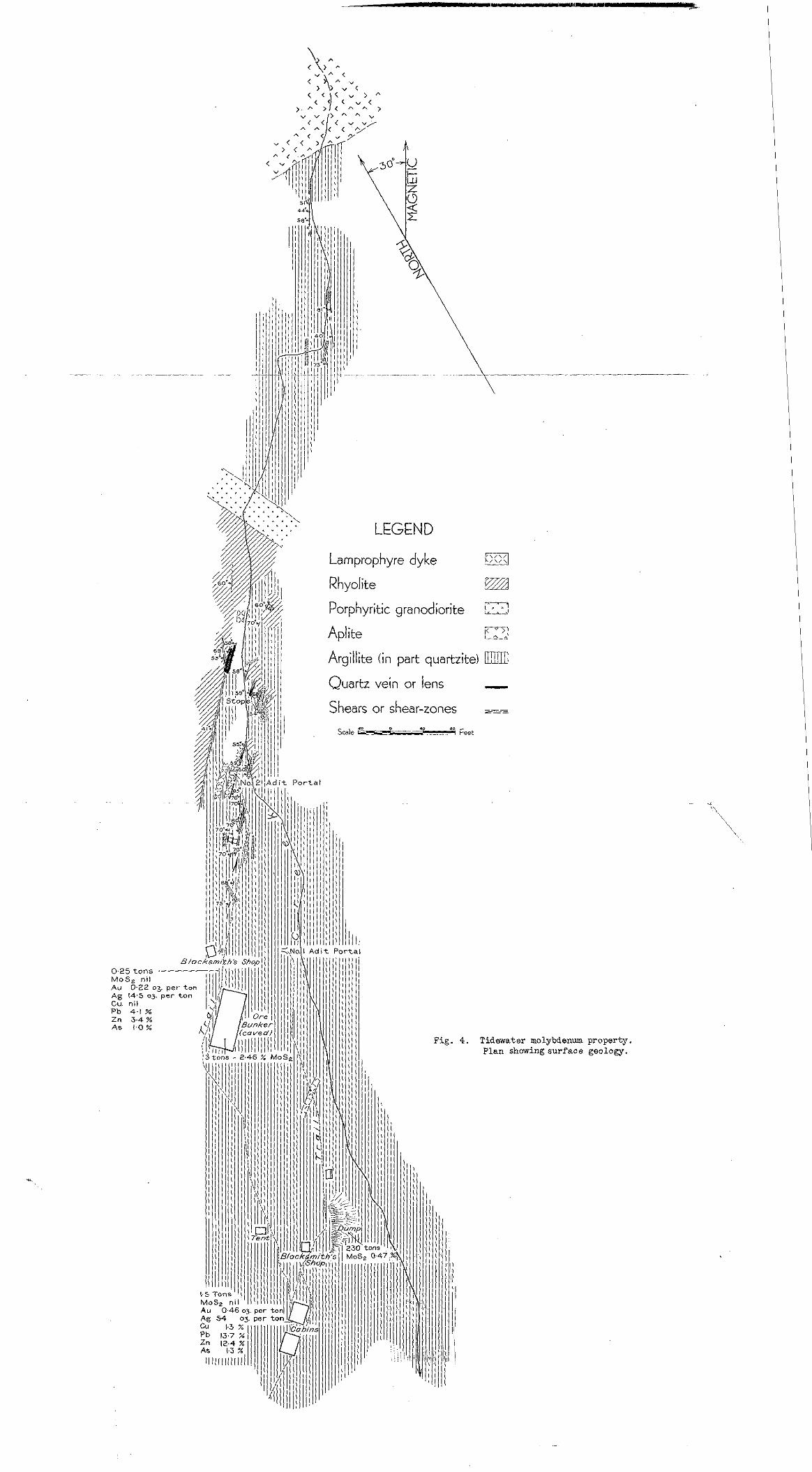
0 M A
.25 tons ' o s z nil
A g 14.5 0 3 " 0.22 c
Cu. nil Pb 4.1 9s 2" 3.4% As 1-0 %
LEGEND
Lamprophyre dyke pc?J Rhyolite Em Porphyritic granodiorite D Aplite E2 Argillite (in part quartzite) mm0 Quartz vein or lens - Shears or shear-zones
Scale P" I Feet .D 0 - .a eo
Fig. 4. Tidewater mol.ybdenm property. Plan showing surface geology.
t aken across the bes t minera l iza t ion in the 12- foot zone a s - sayed: Molybdenite, -3 n i l - i r o n , 2 . 9 per cen t . The rock i n these crush-zones i s b o t h s i l i c i f i e d and s e r i c i t i z e d t o s u c h a n e x t e n t t h a t t h e o r i g i n a l n a t u r e of t he rock is destroyed.: however, it i s cons ide red t o be qua r t z -d io r i t e and similar t o t h a t u p - s t r e a m and down-stream. For a sho r t d i s t ance dorm- s t ream from these crush-zones there are numerous t i g h t , wic.ely- spaced s t r ingers o f quartz and p y r i t e and a l i t t l e molybdenite, from 1 i n c h t o 2 inches wide.
A t an e leva t ion of 3400 f e e t . i n a small creek that f lows no r th -eas t e r ly i n to Bo i se Creek and disappears in a rock and
e r s of quar t z and molybdeni te a re exposed in the quar tz -d ior i te snow-sl ide 300 feet up-st ream from the adi t , occasional s t r ing-
bed-rock of the streani.
This property comprises the Molybdenum /A TIDEXVATER MOLYBDENUM and Success Crown-granted claims and
PROPERTY * severa l c la ims he ld by loca t ion . It
a t e s of Alice Arm, who purchased t:he
* f ! 5& ci?
(74) i s owned by G . W. Bruggy and assoc:i-
two Crown-granted claims a t Tax Sa le i n 1930.
Alice Arm i n l e t , a b o u t 4 miles f rom the town of Al ice Arm. The c l a ims a r e on t he no r th s ide and a t t h e head of t h e
The camp and main workings a r e a t abou t 1 ,000 f ee t e l eva t ion and about 1 mile from the beach.
The a r e a i s reached by c o a s t a l s t e a m e r t o A l i c e Arm a-ad thence by launch t o t h e p r o p e r t y , camp and workings. A good pack-horse t r a i l extends from the beach.
The property i s on the lower southern s lopes of t h e C h a l -
and a d i t s , t h e h i l l s i d e has a general s lope of about 15 degrees , oner Range of the Coast Mountains. From t h e beach t o t h e :amp
x i t h i n t e r v e n i n g k n o l l s and r i d g e s , and i s covered by f a l l e n and some s tanding burnt t imber and by character is t ic underbrush. From t h e camp t o t h e n o r t h e r n e x t r e m i t y of t h e s u r f a c e showings, a t 1 , 3 7 0 f e e t e l e v a t i o n , t h e h i l l s i d e h a s a genera l s lope of
a rea of g r a n i t i c r o c k s , t h e s lope s teepens and t he h i l l s i d e 25 degrees. North of t h i s e l e v a t i o n , and to,.vards and i n t h e
becomes more rugged. Green timber composed mainly of hemlock, wi th some spruce and cedar, extends up t h e h i l l s i d e t o t i m b e r - l i n e a t abou't 3,500 f e e t e l e v a t i o n .
The o ld m i l l bu i ld ings , tramway and bunkers have completely co l l apsed , bu t one cab in , a t an e l eva t ion of 1 ,005 f ee t and t w o -
*A synopsis of a r e p o r t by Joseph T. Mandy.
- 61 -

blacksmith-shops s t i l l s t and and a r e i n good condi t ion .
The cabin i s equipped t o accommodate t h r e e men and t he blacksmith-shops are equipped for hand-steel work. There i s no machinery on t h e ground.
c i e n t for camp use , a l t ,hough dur ing dry per iods the volume would be grea t ly reduced .
The volume of wa te r i n t he c r eek would be probably suff i -
.ings f o r mining requirements and there i s abundant firewood c l o s e a t hand.
There i s s u f f i c i e n t t i m b e r i n t h e l o c a l i t y of t h e work-
The d e p o s i t c o n s i s t s of numerous disconnected lenses of quartz mineralized with varying amounts of molybdenite.
The rocks i n t he a r ea i nc lude s ed imen t s and some greenish andes i t i c dykes of t h e lower Hazelton group of Mesozoic age, intruded by g r a n i t i c r o c k s of t he Coast Range b a t h o l i t h . The main e a s t e r n c o n t a c t of t h e b a t h o l i t h l i e s 1 mi le t o t h e west of t he p rope r ty .
g i l l i t e s , a rg i l l aceous s ands tone , s ands tone and q u a r t z i t e and The sedimentary rocks consis t of i n t e rbedded s l a t e s , a r -
poss ib ly some beds of w a t e r - l a i n t u f f . The rocks have a genera l no r th -eas t e r ly t o ea s t e r ly t r end and a l though fo lded w i th va ry -
ward dip. These rocks are intruded by numerous hard and f ine- ing degrees of i n t ens i ty , t hey have a comparat ively s teep south-
grained, greenish andesi t ic dykes of pre-ba thol i th age .
A l l t he above rocks a r e i n t ruded by spu r s and dykes re- l a t e d t o t h e b a t h o l i t h . In t h e v i c i n i t y of the showings, these
dykes and numerous lamp'rophyre dykes which s t r i k e i n a genera l spu r s cons i s t of bodies of a p l i t e a n d r h y o l i t e , some g r a n i t i c
r o c k s a n d t h e i r s t r u c t u r a l r e l a t i o n s a r e e s p e c i a l l y w e l l - e x - no r th -eas t e r ly d i r ec t ion and dip steeply westward. These
posed along the beach and in the creek-canyon.
A p l i t e and r h y o l i t e o c c u r t o t h e n o r t h and west of t h e molybdeni te-bear ing quartz veins and appear to limit t h e con- t i n u i t y of t h e v e i n s . On the sur face , F ig . (4), t h e v e i n s s t r ike no r th -eas t e r ly t owards a body of p ink ap l i t e wh ich t r e n d s e a s t e r l y . As t h e a p l i t e i s approached the fe ldspar con- t e n t of the veins increases and the veins merge wi th t h e ap- l i t e . I n t he unde rg round work ings an apprec i ab le f e ldspa r content i s ev iden t i n p l aces i n t he ve ins i n t he i r mos t no r - ther ly exposures .
- E2 -

. . . , . LEGEND
Larnproph$edyke , , : . . ~ . . . . . , Quartz vein or lens s s s s
Rhyolite ! : : ~ ; . EZZ Shearing
Argillite : j';;:,: .~ S;a,81 k0i ' L
, ** _"
""
, , . , . . ""j
. . . , . . . . . . . , a
Feet

ve ins from the wes t and d i s r u p t s t h e i r c o n t i n u i t y , b o t h on A body of r h y o l i t i c r o c k F i g . ( 5 ) , converges towards the
sur face and i n t h e n o r t h e r n s e c t i o n of No. 2 a d i t d r i f t . Lo- c a l l y t h e a p l i t e a t t h e n o r t h e r n end of t h e showings contains patches and streaks of disseminated molybdenite. The ev.idence s u g g e s t s t h a t t h e v e i n s and molybdeni te mineral izat ion or igin- a t e d f r o m t h e b a t h o l i t h a t a l a t e s t a g e i n i t s consol ida t ion . The ve ins could be c lass i f ied as pegmat i t ic quar tz ve ins .
Shewing i s p r e v a l e n t a l o n g l i n e s s t r i k i n g between n o r t h and no r th -eas t e r ly and dipping steeply westward, genera1:ty fol lowing the contacts of t h e dykes with the sedimentary rocks. Loca l ly , the shear ing cu ts the ve ins and the l amprophyre dykes . Some fau l t i ng has occu r red , bu t no appreciable displacements o f t he fo rma t ion o r t h e v e i n s i s ev ident . Lamprophyre dykes c u t t h e v e i n s , and i n t e r r u p t t h e i r c o n t i n u i t y so tha t p ro j eo - t i o n of t h e v e i n s a l o n g t h e i r s t r i k e and d i p i s d i f f i c u l t .
t e rmi t t en t ou tc rops , P ig . (4 ) , between 1,015 and 1 ,344 f ee t e leva t ion , a long a ho r i zon ta l d i s t ance of 920 f e e t . They out- c r o p i n a creek-canyon, in both the bed of t he c r eek and on the canyon-walls, Fig. ( 4 ) . These veins comprise quartz s t r ingers , ve ins and lenses , ranging f rom a f r a c t i o n of a n
d e n i t e . The molybdenite i s e r r a t i c a l l y d i s t r i b u t e d w i t h f t n t h e inch t o s eve ra l f ee t w ide , mine ra l i zed w i th f i ne -g ra ined molyb-
ve ins as t h i n r i b b o n s and t o a small ex ten t as disseminated mater ia l wi th in the ve in-quar tz . As t h e q u a r t z g e n e r a l l y breaks a long the r ibbon-banding, f reshly broken vein-matter can e ive a most deceiving appearance of sol id molybdeni te min- e ra l i za t ion , whereas t h i s mine ra l occu r s on ly a s a t h i n c o a t -
shadowy banding of t h e q u a r t z i s t h e only evidence o f miner- ing on the wai l s o f t he f r ac tu red qua r t z . Loca l ly , a mere
molybdenite i s v i s ib l e unde r a magnifying glass. The on:.y s u l - a l i z a t i o n , and, when such material i s broken, f inely-divided
phide accompanying the molybdeni te in the lower exposures and main workings i s a small amount of p y r i t e . The molybdenite mine ra l i za t ion i s confined t o t h e q u a r t z v e i n s and does not pene t r a t e t he wa l l - rooks .
The v e i n s a r e exposed in the workings, Fig. (5 ) , and .in-
A s the ve ins approach and merge w i t h t h e a p l i t e t o t h e no r th , t he t endency t o d i spe r se i ho reases , t he s t r i nge r s be- come smal le r and t i g h t e r , t h e p y r i t e c o n t e n t i n c r e a s e s and ga lena , spha le r i t e , a r senopyr i t e and some cha lcopyr i te begin t o occur . In t he ap l i t e , some s h e a r i n g s i m i l a r i n s t r i k e t o t h a t of t h e q u a r t z v e i n s i s loca l ly wel l -minera l ized w i t h ga lena , spha ler i te , a r senopyr i te , some c h a l c o p y r i t e a n d t e t r a - hed r i t e . In former years , soma work was done on t h e s e show- ings, but the workings have sloughed and a r e now covered with
- 63 -

t a l u s . The ap l i te , in to which the molybdeni te -bear ing quar tz veins appear t p merge, l oca l ly con ta ins some s t r e a k s and patches of molybdenite.
The q u a r t z v e i n s , s t r i n g e r s and l e n s e s s t r i k e i n a gener- a l n o r t h - e a s t e r l y d i r e c t i o n and dip s teeply north-westward. Loca l var ia t ions in s t r ike and d ip a re f requent . The ve in w a l l s c o m o n l y v a r y i n d i p . These f e a t u r e s t e n d t o produce v a r i a t i o n s i n w i d t h w i t h i n s h o r t d i s t a n c e s end g r e a t i r r e g u - l a r i t y i n h o r i z o n t a l a n d v e r t i c a l c o n t i n u i t y . A d d i t i o n a l d i s -
t h e v e i n s . These dykes c o n s t i t u t e a l a rge p ropor t ion of t h e rupt ions of c o n t i n u i t y are caused by lamprophyre dykes c u t t i n g
r o c k i n t h e l o c a l i t y of t he ve ins and f r equen t ly form both walls o r completely encompass the quar tz masses . Where t h e ve ins ez t e r l a rge a r eas o f a rg i l l aceous rocks , t hey t end t o f o r m small. s t r i n g e r s a n d t o d i s p e r s e . T h i s i s ev ident bo th underground and on t h e s u r f a c e , e s p e c i a l l y i n t h e most south-~
most souther ly exposures in No. 1 a d i t . Horizontal c o n t i n u i t y e r l y outcrops south of t h e p o r t a l of No. 2 a d i t and i n t h e
of t h e v e i n s i s a l so d i s rup ted a s t hey approach ap l i t e and rhy - o l i t e a r e a s , t h e main masses of which l i e t o t h e w e s t and no r th . Small tongues of these rocks , however, a l s o p r o j e c t i n t o t h e c e n t r a l s e c t i o n o f t h e showings. The i n t r u s i o n of these tongues is probably responsible for some of t h e b l i n d o r i so l a t ed .masses of quar tz occur r ing i n the workings .
On t h e s u r f a c e , t h e q u a r t z becomes more g l a s s y and t h e oc- c u r r e m e o f f e ldspa r more f r equen t a s t he ve ins app roach t he r h y o l i t e and a p l i t e . Underground, t h e same c h a r a c t e r i s t i c s
decrease in the molybdeni te conten t of t h e q u a r t z v e i n s e s p e c - p r e v a i l t o t h e n o r t h a l o n g No. 1 and No: 2 a d i t s w i t h a marked
i a l l y e v i d e n t i n No. 1 a d i t . In t h i s s e c t i o n of t hework ings ,
norther ly exposures of b o t h a d i t s . The ev idence i nd ica t e s t he q u a r t z i t e s become more abundant and are very comon in t h e most
cl.ose approach o f t h e m o s t northerly underground workings of both No. 1 and No. 2 a d i t s t o i n t r u s i v e r o c k s and the conse- quen t d i s rup t ion o f t he con t inu i ty of t h e v e i n s i n t h i s d i r e c - t i o n a t t h i s g e n e r a l e l e v a t i o n .
s t r u e d t o have been a s f o l l o w s : A summary of the geologica l sequence of events i s con-
1. Deposit ion of sedimentary rocks.
3. I n t r u s i o n of g r a n i t i c r o c k s . 2 . I n t r u s i o n of green dykes.
4 . F rac tu r ing . 5 . Formation of quar tz . 6. Crushing and formation of r i bbon- s t ruc tu re w i th in
t h e v e i n s .
- 64 .-

8 . I n t r u s i o n of lamprophyre dykes. 7. Deposit ion of molybdenite.
9. Late shear ing.
De ta i l s o f t he su r f ace geo logy a r e shown i n F i g . (4.).
The property i s r e f e r r e d t o i n The Annual Report , Blin- i s t e r of Mines, B r i t i s h Columbia, f o r t he yea r s 1916-191.8 in- c l u s i v e and 1928-1931, i nc lus ive , and in G.S.C. Reports by McConnell, (1913, p. 93) , Doimage, (1922, p. 30-A) Wilmot, (1925, pp. 44-46) and Hanson, (1935 pp. 37-38). For ref'er- ences s ee b ib i iog raphy a t t he end of b u l l e t i n .
I n 1916 t h e mine was operated by t h e Molybdenum Mining and Red.uction Company, (C.P. R i e l , Manager). This company b u i l t a 1 0 0 - t o n f l o t a t i o n p l a n t a t t h e b e a c h , and made oonnec- t i ons w i th t he work ings by a n a e r i a l tramway. A desc r ip t ion
Annual Report , Minister of Mines, B r i t i s h Columbia, 1916, o f t h e equipment and mill. i s given by J . M . Turnbul l , in the
pp. K-66-67.
t h i s p l an t because :Nilmot, (1925, p . 45) , says : I t appea r s , however , t ha t ve ry l i t t l e o r e was t r e a t e d i n
" O f t h e 383 tons of ore tha t were sh ipped , a l l exccpt 5 tons w a s s e n t t o t h e I n t e r n a t i o n a l Molybdenum Com-
grade of the ore being 1 . 6 0 per cent MOS2 in s t ead of pany 's concentrator a t Renfrew. Owing t o t h e a v e r a g e
t h e Renfrew company were unable t o make a concent ra te 3 per cen t . as was expected, and t o i t s complex na ture ,
and re fused t o accept m o s t o f the shipments. About 45 tons of the t a i l ings , which appeared to be a lmost as r i c h as t h e o r i g i n a l o r e , was s e n t t o Ottawa and r e - concentrated, as a r e s u l t of which 1,368 pounds of' molybdenite w a s recovered.
"The Department of Mines was approached w i t h a view t o t r ea t ing t he r ema in ing o re a t Renfrew, but t h e mo:.yb- deni te market had then co l lapsed and the o re was not shipped. "
t o s u r f a c e o f f t h e e a s t d r i f t of No: 2 a d i t . The output f rom th i s opera t ion came f r o m the sma l l s tope
the p rope r ty remained i d l e u n t i l April 1930, when work was re - From t h e t ime o f ce s sa t ion of t hese ope ra t ions i n :1916,
sumed by the Dalhousie hlining Company, Limited, (D. S. Wit, Secre ta ry) . This work cons is ted of d r i v i n g t h e Eo. 1 a d i t , and d r i f t i n g i n No. 2 a d i t . Work stopped on A p r i l 23rd:. 1931.
- 65 -

of 2700 pounds t o t h e Canada Department of Kines'. Ore 3ress- ing and Metallurgical Laboratories, Ottawa. A de ta i l ed des - c r i p t i o n of t h e m e t a l l u r g i c a l t e s t s on t h i s o r e may be found in t he Depa r tmen t ' s Repor t No. 393.
In 1931 the Dalhousie Mining Company shipped a sample
Very l i t t l e s u r f a c e work has been done, o r if it had been done i n former years the openings have now sloughed or a r e
t a b i i s h e d e n t i r e l y by in t e rmi t t en t ou tc rops a long t h e bed and covered wi th t a lus . Sur face cont inui ty of t h e v e i n s is es -
banks of the c reek , F ig . ( 4 ) .
Underground development, Fig. (5) , has been car r ied 'ou t i n two main a d i t s a t r e s p e c t i v e l y 1,01.5 and 1 , 1 2 1 f e e t e l e v a - t i o n . No through-raises connect No. 1 and 2 a d i t s . One r a i s e has been .started a t t h e n o r t h e r l y end or^ No. 1 a d i t and ex- t ends f o r 5 9 f e e t . The small s tope o f f No. 2 a d i t e x t e n d s t o t he su r f ace . "wo shallow winzes have been sunk from No. 1 and No. 2 ad i t s ; t h e s e were f u l l of water in October, 1939.
The d e t a i l s o f t h e a s s a y r e s u l t s and t h e sample loca t ions , a r e i l l u s t r a t e d on F ig . ( 6 ) .
The method of cu t t i ng channe l s amples ac ross t he ve ins by hand moils was used throughout the examination. Whenever poss ib l e , t hese channe l s were even ly spaced a t i n t e rva l s of 5 o r 10 fee t , occas iona l ly c lose r , t o mee t t he mine ra l i zed cha r - a c t e r i s t i c s of s p e c i f i c s t r e t c h e s of ve in . In sections where s t r i n g e r s o c c u r r e d , t h e s t r i n g e r s o r veins were sampled either exc lus ive o r i n c l u s i v e o f t he i n t e rven ing rock w i th t he i dea
where cer ta in widths of s t r i n g e r s w e r e s e l e c t i v e l y sampled, of ob ta in ing t he g rea t e s t deg ree o f accuracy. In sec t ions
wid th w i t h the in te rvening wid th of rock inc luded in the ca l - t he a s say va lue i s ca iou la t ed ac ross a t o t a l p r a c t i c a l mining
c u l s t i o n a s c o n t a i n i n g no molybdenite.
Because of t he marked ly l en t i cu la r na tu re and d i scon t in - u i t y of t h e l e n s e s w i t h i n s h o r t d i s t a n c e s , ' b o t h v e r t i c a l l y and horizontal ly , anyone making tonnage estimates from the assays a s shown i n T i g . ( 6 ) , must make t h e c a l c u l a t i o n s w i t h d u e r e - gard f o r such uncer ta in ty in t h e p r o j e c t i o n of vein l engths and wid ths .
The best grade molybdeni te mineral izat ion noted on t h e proper ty occurs in the o ld s tope o f f No: 2 a d i t ( u p p e r ) . In
molybdenite for a l eng th of 1 2 f e e t , and a width of 4.1 f e e t , th is working sampling indicates a grade of 2 .65 per cent .
bu t t he t onnage of t h i s m a t e r i a l i s small and l imi t ed .


In No. 1 a d i t , t h e b e s t g r a d e . i n d i c a t e d i s 1.05 per cent. molybdenite f o r a length of 78 f e e t and a width of 3 . 9 fee t . .
The mode of occurrence, type of deposi t and geological
probable l imi ta t ion of c o n t i n u i t y of t h e m i n e r a l i z a t i o n t o t h e s t ruc tu re r e l a t ive t o t he mine ra l occu r rence , i nd ica t e s t he
nor th bjj mergence w i t h i n t r u s i v e a p l i t e , and t o t he sou th by s t r i n g e r i n g of the quar tz in the sed imentary rocks . In depth,
widths of quar tz occur , there i s d e f i n i t e i n d i c a t i o n of dimin- approach t o i n t r u s i v e r o c k i s a l so ind ica ted and a l though good
u t i o n i n g r a d e .
Should fu r the r exp lo ra t ion be done 01: t h i s p rope r ty . it i s reconrrended that t h i s be confined to surface trenching to- wards the south f rom the p resent known southern limits of t h e ve ins w i t h open-cutting of any vein exposures as warranted. Some e x p l o r a t o r y d r i f t i n g s o u t h i n No. 1 a d i t on known s t r u c - t u r e s , would a l s o be cons t ruc t ive .
The L.H. group comprises the mineral claims, L-H GROUP (80) a, L.H. No: 1, and L.H. No. 2 , s t a k e d i n
1938 by X. 'N. Lynes, Sicamous, E. C . and 0. Hoglurid, and owned by t h e same men. The .wr i t e r examined t h i s p r o p e r t y i n August, 1939.
kwa, a s t a t i p n and small se t t lement on the Canadian Pacific. Railway and on t h e Trans-Canada Highway, approximately 36 mi les west of Revelstoke. Prom Malikwa s t a t ion , t he p rope r ty i s reached by a motor - road tha t fo l lows the wes t s ide of Eagle River nor ther ly for a d i s t a n c e o f 2.2 mile.s, as measured from t h e s t a t i o n . From this poin t a f a i r l y s t e e p t r a i l i s followed
t h i s i s a good pack- t r a i l f o r approximately one-third of the f o r 8000 f ee t t o t h e camp-cabin a t an e leva t ion of 2720 f e e t :
d i s t a n c e from t h e end of the motor-road.
The property i s approximately 3 miles north,-west of Mala-
on e i t h e r s i d e of the, creek i s s t eep , heav i ly wooded and cov- ered with extensive overburden.
The work ings a r e i n t he bed of a creek. The h i l l s i d e
Most of the molybdeni te occurs (i) i n a shear-zone ap-
westward within pink grani te , and ( 2 ) in widely-spaced shears proximately 4 f e e t w i d e t h a t s t r i k e s n o r t h and d i p s 25 degrees
t h a t o c c u r i n t h e g r a n i t e i n t h e h a n g i n g - w a l l of t h e main :;hear- zone. The molybdenite occurs as paper - th in films i n t h e c1n-v-
ter.ed grains i n t h e more mass ive g ran i te between t h e s h e a r s . i ng s l i p s a s soc ia t ed w i th t he shea r ' s and occas iona l ly a s s ca t -
Samples taken across the shear -zone and elsewhere i n the gran- i t e where molybdeni te occurs , indicate that , a l though the
molybdeni te as a mineral i s conspicuous , the ac tua l molybden-
d e n i t e 0.4 per cent . i t e c o n t e n t i s low; the h ighes t assay ob ta ined was: Molyb-
The rocks on the proper ty inc lude p ink gran i te , g ran i te - gneiss , quar tz-mica schis t and a few lamprophyre dykes.
The p ink gran i te appears to be a be l t approximate ly 100 f e e t w i d e t h a t s t r i k e s n o r t h and i s bounded on t h e e a s t by grani te-gneiss and on t h e w e s t by q u a r t z - b i o t i t e s c h i s t a n d grani te -gne iss .
it is cu t by the molybdenite-bearing shear-zone and by numerous
no r th and d i p 45 degrees westward. shear-planes, spaced 1 i n c h t o 4' inches apar t , which s t r ike
The g r a n i t e i s medium i n g r a i n and l i g h t p i n k i n c o l o u r .
A widespr'ead development of' s e r i c i t e i s ind ica t ed by t h e l a r g e amount of compact s e r i c i t e w i t h i n t h e s h e a r s , and by t h e
a d d i t i o n t o t h e m o l y b d e n i t e , a few s t r i n g e r s o f qua r t z and c o m p l e t e s e r i c i t i z a t i o n of t h e f e l d s p a r s in t h e g r a n i t e . In
s c a t t e r e d g r a i n s of p y r i t e o c c u r w i t h i n t h e g r a n i t e .
s i s t i n g m o s t l y of po ta sh f e ldspa r , qua r t z and b io t i t e . I t i s d i s t i n c t l y g n e i s s i c and some phases possess a marked augen t ex tu re , cha rac t e r i zed by the wrapping of l a r g e b i o t i t e f l a k e s around lens-shaped fragments of feldspar. The f o l i a t i o n of t h e g n e i s s i s v e r t i c a l and s t r i k e s n o r t h 22 deg rees ea s t . The gneiss extends f o r an unknown d i s t a n c e b o t h w e s t e r l y u p s t r e a m and e a s t e r l y down-stream from t h e p i n k g r a n i t e , and appears t o be the mos t abundant rock in the reg ion .
The g ran i t e -gne i s s i s a. grey, coarse-grained rock, con-
Quar tz -mica sch is t and in te rbedded mass ive quar tz i te ex- tend up-stream for approximately 150 feet f rom the west s i d e
t h e n o r t h - e a s t , b u t t h e d i p i s var iable , ranging f rom near ly of t h e p i n k g r a n i t e . The s c h i s t s t r i k e s f a i r l y u n i f o r m l y t o
h o r i z o n t a l t o 25 degrees south-eastward.
Close t o t h e g r a n i t e t h e s c h i s t i s c u t by a 15-foot wide biot i te- lamprophyre dyke that i s approx ima te ly ve r t i ca l and
q u a r t z i t e i s c u t by a similar dyke that i s here only 4 f e e t s t r i k e s t o t h e n o r t h . A shor t d i s t ance f a r the r up - s t r eam,
wide, and s t r i k e s e a s t e r l y and d ips 20 degrees southward. A t h i r d lamprophyre dyke, 4 f e e t t h i c k , s t r i k e s . n o r t h - e a s t e r l y ac ross t he c r eek f rom nea r t he po r t a l of t h e a d i t : t h i s dyke d ips 20 degrees north-westward.
The workings consis t of a s h o r t a d i t on the south-west
- 68 -

s i d e of t h e c r e e k and shallow open-outs on the north-east s i d e .
west f o r 2 0 f e e t . The f i r s t 5 f e e t of t h e a d i t c u t s t h e mim- The a d i t h a s been driven i n a d i r e c t i o n s o u t h 75 degrees
eral ized shear-zone which s t r ikes norther ly and d i p s 20 de- grees westward; the remaining 15 f e e t o f t h e a d i t p a s s e s o u t of the shear and the face i s i n r e l a t i v e l y m a s s i v e g r a n i t e . The shear-zone i s i n the g ran i t e and ad jacen t t o the hanging- wal l - s ide of a 4-foot lamprophyre dyke that s t r ikes north- eas t e r ly ac ross t he c r eek and d ips 20 degrees north-westward. On the south-west side of t h e c r e e k t h e dyke i s whol ly in p ink grani te , bu t on t he no r th -eas t s ide it i s who l ly i n g ran i t e - gne iss . I t is t o be no ted t ha t t he con tac t between t h e p i n k g r a n i t e and g r a n i t e - g n e i s s s t r i k e s n o r t h e r l y a c r o s s t h e c r e e k from a p o i n t j u s t e a s t of t h e dyke a t t h e p o r t a l o f t he ad i . t .
c a l l y a c r o s s t h e s h e a r a t t h e p o r t a l a s s a y e d : M o l y b d e n i t e ,
t h e p o r t a l on t h e n o r t h s i d e o f the adi t assayed: Molybdeni te , I n i l . No. 3 , 4 f e e t s i m i l a r t o t h e l a s t , b u t on t h e s o u t h s i d e of the ad i t assayed: Molybdeni te , - n i l . No. 4 , ac ross 6 inches of crushed mat ter a t the face assayed: Molybdeni te , 0 . 2 per cent . No. 5, black gouge from a s l i p a t the face assayed: Molybdenite, 0.2 per cen t . No. 6, 4 . 0 f e e t v e r t i c a l l y i n t h e face assayed: Molybdenite, 0.4 per cen t .
The following samples were taken:No: 1, 4 . 5 f e e t v e r t i -
I n i l . No. 2, 4 f e e t v e r t i c a l l y a c r o s s t h e s h e a r 4 f e e t i n from
d i s t a n c e of approximately 60 f e e t up-stream f r o m t h e a d i t . The banks o f t h e c r e e k have been s t r ipped c lean f o r a
On the south-west bank the shear-zone i s exposed f o r approx- imately 2 0 f e e t n o r t h e r l y f r o m t h e a d i t . , A sample taken across it assayed: Molybdenite, nil. , The main shear-zone, as ex- posed i n t h e p o r t a l o f t h e a d i t and for a s h o r t d i s t a n c e up- stream, does n o t cont inue as a d e f i n i t e zone across the creek; it seems t o have been d i s s i p a t e d a s a number of narrow, closely-
made on t h e most prominent of t h e s e a t a poin t 40 fee t nor t .her - spaced shears 2 inches or l e s s w ide ; A small open-cut has been
l y f rom the ad i t . However, samples across these mineralized shears assayed: Molybdenite, - n i l . Up-stream from t h e opex- c u t t h e g r a n i t e i s cu t by many shears , some of which contain films of molybdenite. Several samples were taken, but only
ac ross a s h e a r a t a point 30 fee t up-s t ream from the open-cut one assayed anything in molybdenite. This sample, taken
assayed: Molybdenite, 0.3 per cen t .
Inasmuch as the molybdeni te i s c o n f i n e d t o t h e p i n k
fur ther p rospec t ing should be confined t o a r e a s a l o n g t h e oon- g r a n i t e and more l o c a l l y t o s h e a r - p l a n e s w i t h i n t h i s g r a n i t e ,
- 69 -

t i n u a t i o n of t h i s b e l t , e i t h e r s o u t h - w e s t e r l y d i a g o n a l l y down t h e h i l l s i d e , or nor th -eas t e r ly d i agona l ly up t he h i l l s ide .
the creek beds should be examined where they cut the projected Inasmuch a s t he s lopes a r e cove red by abundant overburden,
extension of t h i s b e l t .
STERLING (81) era1 c l a ims : S t e r l i ng Nos. 1 t o 2, in- This property comprises the fol lowing min-
elusive, White Rock Nos. 1 and 2 and White Pine Nos. 1 t o 5. These claims were staked in 1938 and 1939 and a r e owned by August Smith, A. D. Coueffin, J . L. Mason and Barry Sawyer, a l l of Revelstoke, B. C . The w r i t e r examined t h i s p r o p e r t y i n August, 1939.
-
The proper ty i s 34 m i l e s n o r t h of Revelstoke on t h e Big Bend Highway. The camp-cabin i s on t h e e a s t s i d e o f t he h igh - way a t a po in t 700 f ee t sou the r ly f rom the 34 -mi l e Pos t . The workings, east of and approximate ly 100 fee t above the road , c o n s i s t of three shor t ad i t s , open-cu t s and s t r ipp ings .
i s covered by large timber and th ick underbrush , so t h a t p r o s - pec t ing , except in the c reek-beds , i s d i f f i c u l t .
The h i l l s i d e s l o p e s g e n t l y upwards e a s t of the road and
The d e p o s i t c o n s i s t s of molybdeni te , pyr rhot i te and py- r i t e d i s s e m i n a t e d i n bodies of mass ive , s i l i ceous rock t ha t a r e enc losed i n qua r t z -muscov i t e s ch i s t and p h y l l i t e . The s i l iceous rock cons is t s o f abundant o r thoc lase and a lb i te , and , l e s s e r amounts of quartz and disseminated sulphides . I t un- doubtedly represents the high-temperature replacement of t h e s c h i s t and, o r p h y l l i t e , by fel-dspar and quar tz . Remnants of what appear t o be muscov i t e s ch i s t i n t he s i l i ceous bod ie s , sugges t tha t quar tz -muscovi te sch is t was the rock replaced.
The largest replacement body, a s exposed i n No. 3 a d i t , has a width of 4 0 f e e t ; i t s length could not be determined. The second largest , as exposed i n No. 2 adi t , has an exposed width of approximately 35 feet . and may be t h e same body as t h a t exposed i n No. 3 a d i t . A thinner replacement body oc- curs approximate ly th ree-quar te rs of a mi l e no r the r ly from those descr ibed above. This body ranges i n wid th f r o m 1 f o o t t o 2 f e e t , snd has a probable length of 175 f e e t .
Although t h e p y r r h o t i t e i s f a i r l y e v e n l y s c a t t e r e d , t h e molyb- In a l l t h e s e b o d i e s t h e s u l p h i d e c o n t e n t is small.^
d e n i t e i s of e r r a t i c d i s t r i b u t i o n . Assays of t h e b e s t m i n e r - a l i z a t i o n r a n g e , i n a l l the bodies , f rom: Molybdeni te , n i l t o a maximum of 0.6 per cen t .
-
- 70 -

f e r r e d t o i n t h e f o l l o w i n g d e s c r i p t i o n s a s s i l i c i f i e d m a t e r - , ia l , o r as s i l i c i f i e d z o n e s . I t i s t o be no ted tha t the t e rm,
qua r t z , o r thoc la se and a lb i t e , and no t , a s i s more u s u a l , t o s i l i c i f i e d z o n e , r e f e r s i n t h i s i n s t a n c e t o s i l i c i f i c a t i o n by
s i l i c i f i c a t i o n by quar tz a lone .
The bodies of high-temperature. replacement w i l l be r e -
"No. 1" a d i t i s dr iven nor th 32 degrees eas t f o r 1 2 f e e t , t h e n From a p o i n t t h a t i s 300 f e e t e a s t of t h e c a b i n , t h e
no r th 22 degrees eas t f o r 36 f e e t , t h e n n o r t h 32 deg rees ea s t for 90 f e e t t o t h e f a c e . From t h e f a c e , a r a i s e h a s been d r iv - en ea s t e r ly on an angle of 30 degrees for 14 f e e t , t h e n v e r t i - c a l l y f o r 11 f e e t t o t h e t o p .
The o n l y m i n e r a l i z a t i o n i n t h i s a d i t c o n s i s t s o f dissem- ina t ed py r rho t i t e in t h e s i l i c i f i e d rook nea r t he po r t a l ; molybdeni te and o ther su lphides a re absent .
of completely s i l ic i f ied sediments , and then through 90 fee.t of b l a c k , l u s t r o u s p h y l l i t e t o t h e f a c e . Near t h e f a c e t h e
north-eastward and a t 60 feet from the p o r t a l it s t r i k e s a b o u t phy l l i t e s t r i kes no r th 55 deg rees wes t and d i p s 25 degrees
north and dips 25 degrees eastward. The s i l i c i f i e d s e d i m e n t s n e a r t h e p o r t a l s t r i k e n o r t h 25 degrees ea s t . and d ip 25 de- grees south-eastward. A t 46 f e e t from t h e p o r t a l a s t rong
ward, conta in ing 8 t o 1 2 inches of gouge, has been ,cu t by t h e f a u l t , s t r i k e n o r t h . 3 5 d e g r e e s w e s t , d i p 4 2 degrees nor th-eas t -
a d i t .
Commencing a t the por ta l , the ad i t passes th rough 48 f e e t
From. a p o i n t t h a t i s 60 f e e t i n a d i r e c t i o n n o r t h 84 de- grees eas t f rom the por ta l o f t h e "No. l" a d i t , an open-cut extends f o r 34 fee t eas te r ly t o t h e p o r t a l of "No. 2" a d i t t h a t i s d r i v e n n o r t h 76 deg rees ea s t f o r 30 f e e t t o t h e f a c e . Commencing a t i t s mouth, the open-cut passes through 18 f e e t of overburden, then through 16 f e e t of mass ive , s i l i ceous rock. This rock ex tends i n to t he ad i t f o r 1 8 f e e t from the p o r t a l ; f r o m t h e n c e t o t h e f a c e , t h e a d i t p a s s e s t h r o u g h s i l - v e r y , q u a r t z - m u s c o v i t e s c h i s t t h a t s t r i k e s n o r t h - e a s t e r l y and d ips 25 degrees north-westward. A t 18 f e e t , 2 2 f e e t and 24 f e e t from the mouth of the open-cut, and from 10 f e e t t o 2C f e e t from the po r t a l , i n t he ad i t , , and , a t t h e f a c e , s h o r t discont inuous lenses o f qua r t z , pa ra l l e l w i th t he walls of the workings, have been exposed. These lenses, ranging from a few inches t o 18 inches i n t h i ckness and from 1 f o o t t o 8 f e e t i n length , conta in small amounts of molybdeni te , pyr i te , galena and sphaler i te . Simples taken across the lenses shew- ing t he bes t mine ra l i za t ion a s sayed from: Molybdenite,nil t o 0.6 per cent .
-
- 71 -

50 fee t nor th-eas te r ly up-s t ream f r o m t h e mouth of t h e open- S t r ipp ing on the north-west bank of t h e c r e e k , a t a point
cut, exposes a small 4-inch patch of galena , pyr i te and qua r t z i n a 1arg.er area of massive, s i l iceous rock.
"No. 3'' a d i t i s dr iven f rom the south-eas t bank of t h e
a d i t . The p o r t a l of No. 3 a d i t i s 255 f e e t i n a d i r e c t i o n same c r e e k t h a t f lows south-wes ter ly pas t the mouth of "No. 2"
nor th 2 1 degrees east f rom No. 2 , and is dr iven nor th 30 de-
t a l a branch-working i s dr iven south 86 degrees wes t for 22 g r e e s e a s t for 70 f e e t t o t h e f a c e . A t 52 f e e t from the por -
f e e t .
carbonaceous phyl l i te f o r 28 f e e t , then t o t h e face , through Commencing a t t h e p o r t a l , t h e No. 3 a d i t passes through
p a r t l y s i l i c i f i e d q u a r t z - m u s c o v i t e s c h i s t t h a t s t r i k e s n o r t h - eas t e r ly and d ips 40 degrees north-westward. A t 50-, 58- and 6 6 f ee t f rom the po r t a l , t he ma in -ad i t cu t s l enses of qua r t z and a t 5- and 18 f e e t from this working the branch-working cuts similar lenses. These lenses range from 1 i n c h t o 14 inches - i n t h i ckness and from 6 inches t o 4 f ee t i n l eng th . O the r t han quar tz , they conta in on ly a l i t t l e p y r i t e ; no molybdepite was seen . Apar t f rom the quar tz l enses , the on ly o ther minera l iza- t i o n i n t h i s a d i t c o n s i s t s or' p y r r h o t i t e , p y r i t e and 'small amounts of molybdenite disseminated through the si l iceous re- placement-rock. Two checkerboard samples taken across the f a c e o f the side-working assayed: Molybdenite, 0.4 pe r cen t . and 0.3 per cent . , respeot i .vely.
Seventy-f ive feet nor th-easter ly up-stream from the third ad i t , s t r i pp ing a long t he sou th -eas t s ide o f t he c r eek exposes a f l a t - l y i n g l e n s of qua r t z 14 inches th ick by 3 fee t long , which contains pyri te and some molybdenite. A sample taken ac ross t he Lens assayed: MoJ.ybdenite, 0.4 per cen t .
up-stream from the hlghv(ay-crossing i n t h e bed of a small creek, Showings of molybdenite outcrop approximately 500 f e e t
mi l e s no r the r ly from t h e c a b m . l o c a l l y known as Galena Creek, that crosses the hlghway 0.6
The workings on t h e s e showings c o n s i s t of combined open- cu t s and s t r ipp ings .
From a po in t 2 0 f e e t s o u t h of the creek-bed, an open-out i s d r i v e n 5 f e e t e a s t e r l y t o a 4- foot face . This working outs
which dies out within an exposed length of 8 feet . . The i e n s an i r r egu la r l ens of b a r r e n q u a r t z a t t h e f a c e and on t h e w a l l s ,
c u t s s i l v e r y , q u a r t z - s e r i c i t e s c h i s t that s t r i k e s n o r t h 35 de- grees west and dips 40 degrees south-westward. A zone of
- 72 -

mass ive , s i l i c i f ied rock of i r regular wid th ex tends f rom t h e n o r t h s i d e of t h i s cu t no r th -eas t e r ly ac ross t he c r eek . Th i s
west and dips south-westward with the enclosing schis ts . The zone ranges f r o m 1 f o o t t o 2 f e e t in th i ckness , s t r i kes no r th -
s i l i c i f i e d r o c k c o n s i s t s of abundant orthoclase and a l b i t e ,
den i t e . Three samples taken of the best mineralization as- l e s s e r amounts of quar t z , and s ca t t e r ed py r rho t i t e and molyb-
sayed: Molybdenite, and 0 .5 per cen t .
The s i l i c i f i e d r o c k i s c u t by two bar ren quar tz l enses ; by one in the open-cut f i r s t described, and by a n o t h e r a t 43 f e e t n o r t h - e a s t e r l y f r o m t h e c u t .
e a s t from No. I., i s a n i r r e g u l a r l y b l a s t e d a r e a t h a t e x t e n d s 4 f e e t e a s t e r l y and 1 2 f e e t n o r t h e r l y . I t exposes molybdenite and py r rho t i t e i n t he no r th -eas t e rn ex tens ion of t h e s i l i c i - f i ed rock . A sample taken across 1 foo t of t h e b e s t mineral.- ization assayed: Molybdenite, 0.5 per cent.
No. 2 working, 40 f e e t i n a d i r e c t i o n n o r t h 25 degrees
No. 3 working, 35 f e e t n o r t h e r l y f r o m No. 2 , i s a com- b ined s t r ipp ing and open-cut tha t ex tends 10 fee t a long the
c i f i e d r o c k a n d e n c l o s i n g s c h i s t ; t h e s c h i s t s t r i k e s n o r t h 25 s t r i k e , and 4 f e e t down and 2 f e e t a c r o s s t h e d i p o f t h e s i l i -
degrees west and d i p s 45 degrees south-westward. This expo- s u r e i s probably the northern eA&ension of t h e s i l i c i f i e d r o c k exposed i n and between No. 1 and No. 2 workings. ' Scattered molybdenite occurs i n t h i s exposure and a sample taken across the 2 - foo t t h i ckness of t h e zone assayed: Molybdenite, 0 .2 per cent.
ing, but none of them expose any molybdenite. The fa r thes t trench, 100 f e e t no r the r ly f r o m No. 3, expo'ses 1 f o o t of t h e s i l i c i f i e d r o c k , which contains only a l i t t l e p y r r h o t i t e .
Three trenches have been dug t o t h e n o r t h of No. 3 work-
s i l i c i f i e d r o c k a p p e a r s t o have a s t r i k e l e n g t h o f approximate- l y 175 f ee t and a thickness ranging from 1 t o 2 f e e t .
A s measured between t h i s working and No. 1, t h e zone of
The All ies molybdeni te property com- ALLIES MOLYBDENITE pr i ses the fo l lowing minera l c la ims:
Sunset and Panorama. The mvners a r e Archie Cowie, 355 Nico l S t r ee t , Nanaino, and a s s o c i a t e s of t h e same c i t y . The w r i t e r examined th is p roper ty in Ju ly , 1939.
PROPERTY (91) Y B r i t a i n ~ r a n c s , L p i c t o r i a , ~ c l g , -
The. property i s reached by (1) motor road f o r 15 miles f r o m Nanaimo up t he main sou th fo rk of t h e Nanaimo River t o
- 73 -

t h e Nanaimo City waterworks dam, a t an e l eva t ion of 820 f e e t , thence ISJ (2) approximately 1 6 m i l e s o f t r a i l u p Jump Creek t o t h e Jump Creek-Green.River divide, and f inally by t r a i l up a s t e e p h i l l s i d e t o t h e camp-cabin a t a n e l e v a t i o n of ap- proximately 3,200 feet . With the exception of t h e l as t mi l e t h e t r a i l i s good, and with only a l i t t l e c u t t i n g , q u i t e s u i t - ab l e f o r pack-horses; t h i s t r a i l i s in t h e E. and X. Railway
Railway. The l a s t mi l e t o t h e cabin , a l though not i n a burn t - Bel t and i s kept open as a f i r e t r a i l by t h e Canadian Tac i f i c
over a rea , i s covered by numerous windfa l l s of l a rge t imber , and because of' the frequency of t h e s e . fa l l s it would be unwise t o a t tempt to keep t h i s p a r t o f t h e t r a i l open.
The showings a r e on t h e s t e e p n o r t h e r l y s l o p e s of M t . Bu t t l e . For t h e most p a r t t h i s h i l l s i d e i s heav i ly wooded w i t h l a r g e hemlock, but towards the top and i n t h e v i c i n i t y
p r e v a i l . The upper par t s of M t . E u t t l e , between e l eva t ions of t h e showings, steep, rock canyons, i n p a r t i n a c c e s s i b l e ,
of 4 ,100 and 4 ,900 f ee t a r e r e l a t ive ly open and the cove r a l - pine.
The d e p o s i t c o n s i s t s of s i n g l e q u a r t z v e i n s t h a t c a r r y small amounts of molybdenite. The ve ins r ange i n w id th from 1 i n c h t o 54 inches, and i n exposed length, from a few f e e t t o
measures 6,500 f e e t i n a no r th - sou th d i r ec t ion , by 1,800 f e e t an observed maximum of 37 f e e t . They occur over an area that
i n a n east-west d i r e c t i o n ( F i g . 7 ) . Samples taken by t h e writ- er from mineralized quartz veins assayed from: Molybdenite, t r a c e t o 0.4 per cent .
d io r i t e t h rough g ranod io r i . t e t o g ran i t e i n compos i t ion . Show- ings Nos. 1 t o 16 , i n c l u s i v e , a r e i n q u a r t z - d i o r i t e ; Nos. 1 7 and 18 i n g r a n o d i o r i t e , and Nos. 2 2 and 23 i n g r a n i t e ; Nos. 19 t o 2 1 a r e i n p y r i t i z e d g r e e n s t o n e .
The qua r t z ve ins cu t g ran i t i c rocks t ha t r ange f rom qua r t z -
t ends ' sou the r ly f rom the cab in for approxlmately 3,500 f e e t ,
were seen on t h e t r a i l for approximately one mi l e no r the r ly and e a s t e r l y fo r a minimum d i s t a n c e of 1,000 fee t . Outcrops
from t h e camp-cabin; t raverses were no t made t o t h e e a s t . The quar tz -d ior i te , as exposed on the Al l j -es , p robably repre
no r th -eas t e r ly . sents t h e s o u t h - w e s t e r l y p a r t of a l a r g e mass tha t extends
Q u a r t z - d i o r i t e i s the most abundant rock type, and ex-
was observed i n a canyon a t a point towards the southern mar- g i n of t h e a r e a of q u a r t z - d i o r i t e ; t h e a c t u a l c o n t a c t w i t h t h e q u a r t z - d i o r i t e was n o t seen.
A s e c t i o n of granodior i te , approximately 500 f ee t w ide ,
- 74 -

Andesit ic greenstone occurs on the ea s t and wes t peaks of But t l e Mountain, and extends northerly down t o a bench 500 f e e t below; t h i s bench i s 800 f e e t above and 2 ,500 f ee t sou th - e r l y from t h e camp-cabin.
Grani te dykes cu t the g reens tone in many p laces , and ex- tend from the bench south-eas te r ly over the pass be tween the
north-wester ly and r ange i n w id th f r o m 25 f e e t t o 750 f e e t . e a s t and west peaks of Buttle Mountain. These dykes strike
The following paragraphs form a d e t a i l e d d e s c r i p t i o n of t h e showings, t h e i r p o s i t i o n i s given on Fig. 7 .
No. 1 i s a c u t t h a t h a s been dr iven south 23 degrees exs t for 17 feet . This cut exposes a q u a r t z v e i n t h a t s t r i k e s s o u t h 25 degrees east , dips 80 degrees north-eastward and ranges
and conta ins on ly a small amount o f su lphides . The su lphides from 18 t o 20 inches in wid th . The ve in i s most ly milky quartz
molybdenite; the molybdenite occurs as r o s e t t e s from 1/4 t o include patches of p y r i t e , a l i t t l e c h a l c o p y r i t e and a l i t t l e
1/2 an inch in d iameter .
The cont inua t ion of t h i s v e i n i s seen 20 fee t nor th-wes t - e r ly i n t he bed o f the creek, where it is 2 fee t wide and ex- posed f o r 14 f e e t . Only one small patch o f molybdenite was seen, 5 inches long, and 3/4 of an inch a t i t s wides t pa r t .
No. 2 i s a water-hole 5 f ee t squa re by one foot deep; d i r t i n t h e bottom obscured the vein reported t o be t h e r e . Mater ia l on t h e dump c o n s i s t s of quar tz conta in ing pyr i te .and small amounts of molybdenite intimately associated with the p y r i t e .
wide quar tz ve in f o r 3 f e e t . THe qua r t z con ta ins py r i t e and a few molybdeni te roset tes .
Xo. 3 i s a t r ench 1 2 f e e t long t h a t exposes an 18-inch
mately 5 f e e t i n diameter by 2 fee t deep;quar tz boulders of minera l i za t ion similar to the above a re sca t te red a round it.
No. 4 i s a n i r r e g u l a r l y shaped w a t e r - f i l l e d p i t approxi.-
No. 5 i s a wa te r - f i l l ed p i t t ha t d id no t r each bed - rock .
No. 6 i s a s h a f t f i l l e d w i t h w a t e r , and i s r e p o r t e d t o be approximately 50 fee t deep . A ve in con ta in ing t r aces of s u i p h i d e s i n t h e q u a r t z ' a n d r a n g i n g i n w i d t h f rom 15 t o 18
wes te r ly ac ross t he rock - f loo r of t h e canyon f o r a d i s t ance of inches, extends from the north-west corner oE t h e sha f t no r th -
15 f e e t . A picked sample from the dump assayed: Molybdenite,
- 75 -

Fig. 7. Allies molybdenite property: pace, compass Bnd barometer survey.
1.5 per cen t . Severa l o ther ve ins were . seen in the f loor of
veins range f r o m one i n c h t o 10 inches in width and conta in t h e canyon down-stream and u p s t r e a m f r o m t h e s h a f t . These
t r a c e s of molybdeni te ; the posi t ion and s t r i k e o f t h e s e ve:ins, showings Nos. 7 t o 16 , i nc lus ive , a r e w i th t he excep t ion of No. 10, shown on Fig. 7 .
No. 10 i s an open-cut tha t has been dr iven f o r 1 8 f e e t a t south 39 degrees eas t t o a f a c e 10 fee t h igh . The v e i n i n t h e f a c e i s 4 f e e t wide and contains patches of p y r i t e and
width o f the vein assayed: Molybdenite, 0.4 per cent . small amounts of molybdenite. A sample t a k e n a c r o s s t h e f u l l
v e i n s i n a rocky canyon; they range from 2 t o 10 inches wide and c o n t a i n t r a c e s of' molybdenite.
Nos.17 and 18 consis t of narrow, re la t ive ly bar ren quar tz
Nos. 1 9 t o 2 1 are small open-cuts that expose pyri t ized greenstone; quartz veins and molybdenite are absent.
Nos.22 i s an open-cut that has been driven north 45 de- g r e e s e a s t f o r 15 f e e t i n t o t h e north-east wall of a canyoc. I t exposes two s h e a r s i n t h e Face that s t r i k e n o r t h 30 degrees west and d i p f r o m 60 degrees t o 75 degrees north-eastward, but
much more py r i t e t han i s common i n t h e previously descr ibed converge above the working. The shears conta in quar tz w i t h
ve ins , and small amounts of sheared molybdenite. The v e i n ma te r i a l i s l e n t i c u l a r and ranges in width f rom a knife-edge t o 6 inches ; t he re i s no i n c r e a s e i n w i d t h a f t e r t h e s h e a r s converge. In this same canyon t h e r e are two o the r shea r s
t a i n s m a l l amounts of sulphide. t ha t ou t - c rop f o r only a f e w f e e t a l o n g t h e i r s t r i k e and con-
solith 1 2 deg rees ea s t for 28 f ee t fo l lows a quar tz ve in 54 inches w ide t ha t con ta ins a small amount of p y r i t e , p y r r h o t i t e and a t r a c e of molybdenite. This vein has been f a u l t e d w i t h i n 5 f e e t of t h e f a c e .
The ad i t , 80 f e e t below t h e c a b i n , d r i v e n i n a d i r e c t i m
the other 10 inches wide. The qua r t z con ta ins t r aces of su:L- phides.
No. 23 c o n s i s t s of two p a r a l l e l v e i n s , one 6 inches' and
- 76 -

ANNOTATED BIBLIOGRAPHY.
Bureau of Mines, Dept. o f Mines and Resources, Canada, (Mar. 1939). Molybdenite in 1938.
But le r , B. S. and Vanderwilt , J . W. (1933) The Climax Molyb- denum Deposit, Colorado, U . S . Geol. Surv. Bull . 846-C.
Dana, E. S. (1922) Text-book of Minera lom for prope r t i e s of molybdenum min'erals.
Dolmage, V. (1922) Coast and Islands of B r i t i s h Columbia be- tween Douglas Channel and t h e Alaskan Boundary. Geol. S u m . Canada, Sum. Rept . Par t A .
Drysdale, Chas. W. (1915) Notes on t h e Geology of t h e "Molly" Molybdenite Mine, Lost Creek, Nelson, Id. D., Trans. Can. I n s t . Min. Met. Vol. X V I I I .
Jhmons, W. H. (1935) Origin of Ce r t a in Systems of Ore-bearing F rac tu res , Trans. Am. I n s t . Min. and Met., Vol. 115, pp. 9-35.
.. (1938) Diatremes and Certain Ore-bearing Pipes, T. P 891, Am. I n s t . "in. and Met., pp. 1-15.
Hanson, George (1935) Portland Canal Area, British Columbia, Geo. Surv. Canada, Mem. 175.
Bess, F. L. (1923) I lsemannite a t Ouray, Utah, U. S. Geol. Surv. Bull . 750-A.
.. (1924) Molybdenum Deposits, U. S. Geol. Surv., B u l l . 761..
L i l l e y , E. R . (1936) Economic Geology o f Mineral Deposits, Henry Holt and Co., N e w York, pp. 438- 442.
Lindgren, 'Naldemar (1933) Mineral Deposits, McGraw-Hill Book Co., New York, pp. 769-771.
McConnell, R . G. (1913) Port ion of Por t land Canal and Skeena Mining Division, Skeena District , B . C . , Geol. Surv. , Canada, Mem. 32.
Perry, V. D. (1933) Applied Geology a t Cananea, Sonora, Lind- gren, Volume, Am. I n s t . , Min. a;; Mat., pp. 701-705.
".
- 77 -

P h i l l i p s , \'I. H. (1935) Molybdenite--Modern.Uses of Non-fer= Metals; Am. Inst. Min. and Met. Eng., pp. 217-220.
R a s t a l l , R . H. (1922) Molybdenum Ores, I m p e r i a l I n s t i t u t e , London.
Ridgway, R . H. and Davis, H. W. (1939) Minerals Yearbook, Bureau of Mines; pp. 615-620.
Vanderwilt, J. W. (1933) Molybdenite Deposits - Ore Depos i t s of t h e Western States; Am. I n s t . Min. and Met. Eng., i i ndgren Volume pp. 570-573.
. . (1938) Geology of t h e "Quests'! Molybdenite Deposit, ?', County, New Mexico, Colorado S c i e n t i f i c S o c i e t y .
Walker, J. P. (1934) Geology and Mineral Deposits of . the 2:- Map-Area, Bri t ish Col . , Geol . Surv. Canada, Mem. 172.
Walker, T. L. (.1911) Molybdenum Ores of Canada, Mines Bran.ch Pub. No. 93, Dept. of Mines, Canada.
Wilmot, V. L. Eardley - (1925) Molybdenum, Mines Branch, Pub. No. 592, Dept. o f Mines, Canada.
- 7% -

APPENDIX.
INDEX OF KXOWN OCCURRENCES Or" MOLYBDENITE I N BRITIS8 COLUMBIA
(Occurrences marked wi th an a s t e r i sk desc r ibed i n t h i s b u l l e t i n . )
Ashcroft Area
No. a s on
( f r o n t i s p i e c e ) Key Map
1 Martel property*
16 mi les south of Ashcrof't; narrow quartz veins in sediments; extensive underground workings and open-cuts.'
Reference: ( 7 ) p. 18.
2 Tamarack group
Near Gnawed M t . , Highland Valley, 2 0 miles south- e a s t of Ashcroft : Nolybdeni te associated in small amounts w i t h c h a l c o p y r i t e i n j o i n t p l a n e s i n g r a n i t i c r o c k s . Twenty-foot s h a f t , p i t s and s t r ipp ing . Oae t o n of ore shipped.
References: ( 2 ) p. 52; (1 ) p. 32.
Bella Coola Area
3 Heino, A . , p rospec t of
On mainland near Hunter Island, near Ocean F a l l s . F lake molybdeni te in quar tz s t r ingers .
Reference: ( 3 ) p. 124.
4 Merkel, prospect of
Near Bagensborg.
Reference> ( 6 ) .
5 Schonovitch prospect.
Near Namu. Reference: ( 2 ) .
- 79 -
Chilko Lake Area
6 Frankl in Arm, Chilkc Lake.
Occurrence reported by R. P . Bishop of Wic- t o r i a and p o s s i b l y t h a t r e f e r r e d t o i n t h e re ference .
Reference: ( 5 ) 1917, p. 132.
Cranbrcck Area
7 St. Idary's River, forks of
Molybdenum associated with bismuth.
Beference: ( 5 ) 1917, p. 180.
8 Sunnyside-Sunset claims I
Marysv i l l e s t a t ion . Fine-grained molybd.en- In S t . Mary's pass, 20 miles north-west o f
i t e i n q u a r t z v e i n s that occur i n qua r t z i t e .
Reference: (2) p. 5 G .
F t . Fraser Area
9 S t e l 1 a group * Near Endako, south-west of Fraser Lake. Ribbon molybdeni te in quar tz ve ins . Open- c u t s , i n c l i n e a n d a d i t .
Reference: ( 7 ) p. 23
Grand Forks Area
10 Frankl in Camp
ldolybdeni te associated with chalcopyri te in shear -zones in g ranodior i te - no deveiopment.
Reference: (1) p. 49.
- eo -

11 - Midas group*
Near Fa r ron , ea s t of Cascade and Grand Forks on the Ket t le Val ley Rai lway. Molybdeni te d i sseminated in syeni te and in nar row quar tz ve ins . Seve ra l sho r t ad i t s and an i n c l i n e .
Reference: (7) p. 33.
1 2 Thomson e s t a t e , p rope r ty o f *
West, of Lafferty, near Cascade. Molybdenite disseminated in quar tz - fe ldspar gne iss . S t r ipp ings .
Reference: (7) p. 39
Greenwood Area
13 Carmi mine
Near Carmi s t a t i o n , n o r t h of Greenwood. Molybdenite occurs w i t h copper ores, no de- velopment f o r molybdenite.
Reference: (1) p. 49.
14 Younkin prospec t near Br idesvi l le .
7 miles f rom Bridesvi l le on t h e Camp McXinney
ve ins . A small shaft has been sunk on t h e road. Flake molybdenite in a 1- foot quar tz
ve in .
Referenee: (3) p. 127.
15 Younkin prospect near Camp McKinney
5 mi les nor th-eas t of Camp McKinney. 18- i n c h seam of mic'aceous molybdenite.
Reference: (3) p . 127;
Hazelton Area
1 6 Black Prince and 'Uonder
A t head of Mud Creek, which f lows eastward into Bulkley River about 10 miles above New
- 8 1 -

17
18
19
20
2 1
Hazelton. ' polybdeni te and wolframite BE:-
soo ia t ed w i th py r i t e , cha lcopyr i tg and galena.
Reference: (5) 1914, p. 205.
N e w Haeelton Gold-Cobalt Mines
On Rocher D&boulB Xt.., south of Hazeltor. . Molybdeni te occurs in veins of coba l t su.1- ph ides i n g ranod io r i t e . Ex tens ive ad i t s ,
430 lbs . molybdeni te , in 1917 and 1918. s h a f t s and p i t s . Shipped 27 tons y i e l d i n g
Reference: (5) 1917, p. 103.
Thom prospect
Manson Creek t r a i l and 27 miles ' eas t of On Suskwa River 4 miles f rom the Hazel ton-
Hazelton.
Reference: ( 6 )
Kamloops Area
Antic1 imax*
1 7 1./2 miles north-west of L i t t l e F o r t ( l d t . Olie.). which i s 60 mi l e s no r th of Kamloops. Quar t z l ens i n granitic rocks. Open-cuts and s t r i p p i n g s .
Reference: (7) p. 42.
Beresford, South
Prospect a t South Beresford near.Knutsford.
Reference: (6)
Xenallan * An old prospect 4 mi les south of Westwold. Molybdeni te disseminated with sulphides in lime-garnet zones i n l imestone. Numerous; s t r ipp ings , open-cuts and shor t inc l ines .
Reference: ( 7 ) p. 57
- 8 2 -
22 Naismith prospect
Near 2ed Lake, 30 miles north-west of Kam- loops .
Reference: ( 6 )
23 Pearscn prospect
Near Stump Lake.
Reference: ( 6 ) .
24 Sands Creek claims * On Sands Creek, which f lows in to t he C lea r - water River near Clearwater Stat ion. An 18- inch quartz-molybdeni te vein in g r a n i t i c r o c k . S t r ipp ing .
Reference: ( 7 ) p. 65.
Lac l a Hache-
25 Boss M t . * Proper ty of the Consol ida ted Mining and Smelting Co. 40 mi les nor th-eas t of Lac l a Hache. Breccia-pipe in q u a r t z - d i o r i t e
e r a1 small quartz-molybdeni te veins . 3 sea led by qua r t z and molybdenite; also sev-
s h o r t a d i t s , 1 shaft, several open-cuts. 1000 lbs . o f o re y i e ld ing 350 l b s . molyb- deni te sh ipped .
Reference: ( 7 ) p. 68.
Lardeau Area
26 Copper Chief
On w e s t s i d e of Trout Creek, near Trout Lake. A small ve in fo l lowing a d i o r i t e dyke. Several open-cuts.
Reference: (5) 1917, p. 191.
- 8 3 -

27 and - Foss claims, Duncan River.
North of Kootenay Lake. Molybdenite i n quar tz ve ins tha t cu t mica sch is t . Numer- ous open-cuts.
Reference: (1) p. 3 1 . ~
L i l l o o e t Area
28 Croteau prospect
Approximately 20 miles south of Lillooet, near the Index Molybdenite property.
Reference: ( 6 )
29 Index Mine "
On Texas Creek, 15 miles south-west of L i l -
wi th molybdeni te . Severa l p i t s , t renches looet . Fracture-zone i n g ran i t e mine ra l i zed
and a d i t s .
References: (1) p. 34; (4) Summ. 1916, p. 54; (5) 1916, p. 272.
Lower Mainland Coast and Coastal Is lands Area
30 Bentham prospect *
On Haslam Lake, near Powell River. Molyb- d e n i t e i n q u a r t z s t r i n g e r s i n j o i n t s i n g r a n i t e . S t r i p p i n g s .
Reference: ( 7 ) p . 88
31 Bower, Gideon, prospect of
1 1/2 miles from shore o f no r th arm of Bur- r a r d I n l e t and opposite Croker Island.
Reference: ( 2 ) p. 52.
32 Br i tannia Mine.
On Howe Sound.' Molybdenite sometimes asso- c i a t ed w i th cha lcopyr i t e i n shea r -zones .
Reference: (1) p. 52.
- 04 -

33 Clowham Lake, prospect near .
Near S e c h e l t I n l e t . Vague r e p o r t s of show- ings .
Reference: ( 3 ) p. 125.
34 Cortez Island.
t e z I s l a n d . Small q u a n t i t i e s of molybden- Occurrence east of Carr ington Bay on Cor-
i t e i n q u a r t z v e i n s i n g r a n i t e .
Reference: (4) 1886, 'p. 23-B.
35 Cypress Creek, claims near.
molybdenum. On Burrard In le t . Repor ted h igh re turn in
Reference: ( 5 ) p. K-301.
36 __ Gem proper ty
Near Gordon Pasha Lake, near Pwell River .
Reference: ( 6 ) .
37 Grayson-Otto prospect.
On Knight In le t . F lake molybdeni te in nar - row qua r t z ve ins .
Reference: (3) p. 125.
38 J e r v i s I n l e t . *
Pr incess Louisa Arm: S c a t t e r e d r o s e t t e s Prospec t above Je rv is In le t and oppos i te
and patches of molybdenite i n g r a n i t e .
Reference: (7) p. 93
39 Lucky Swede
'Prospec t owned by P e r r y Hanson on Sonoro I s l and .
Reference: ( 6 ) .
- E5 -

40
41
42
43
44
45
46
Lynn Creek
Molybdeni te associated with sulphides and c a l c i t e . S e v e r a l a d i t s .
Reference: (1) p. 5 2 .
Ottawa Cen&r&
Quadra Island, one-half mile west of Bald Poin t . A l i t t l e m o l y b d e n i t e i n l i m e s t o n e .
Reference: (5) 1922, p. 241.
P leasant Lake, prospect near .
5 1/2 mi les south of J e r v i s I n l e t . F l a k e molybdeni te in quartz and grani te .
Reference: ( 3 ) p . L25.
Powell Lake.
Prospect on shores. Fine-grained molybden- i t e i n q u a r t z .
Reference: (1) p. 50,
" Soule claims
Near head of t h e North Arm Bur ra rd In l e t , 2 miles up t h e v a l l e y of a small stream. Mclybdeni te in a 14-inch quartz vein' i n g r a n i t e .
Reference: ( 2 ) p. 52 .
Texada Island.
Assoc ia ted wi th cha lcopyr i te in many of t:he o l d copper mines.
Reference: ( 2 ) p. 50.
M e r r i t t Area
Copper King Mine.
Near Mamette Lake, no r th o f Merritt. ks soc i - a ted with an excess of cha lcopyr i t e i n a l -
- e 6 -
t e r e d g r a n i t e .
47 Bourne prospec t .
Near Nakusp, on Upper Arrow Lake. Molybdenite i n qua r t z veins. Numerous open-cuts.
Reference: (1) p. 49.
Nelson Area
4a F r e e S i l v e r
on Quartz Creek, west of Y m i r . Molybdenite w i t h su lphides in ve in in monzoni te .
Reference: (1) p. 50.
49 Gray Creek prospect * Bast s i d e of Kootenay Lake. 3-foot quartz v e i n i n g r a n i t e . Adi t , 175 f ee t l ong , a long t h e v e i n .
Reference: ( 7 ) p. 49.
50 L i t t l e Keen*
On Sheep Creek, south of Salmo, owned by J. Sapples. Molybdenite i n a l i m e - s i l i c a t e zone. Several open-cuts and s t r i p p i n g s .
Reference: (7 ) p. 97.
51 Lucky Boy
Sou th . s ide of Sheep Creek, near Salmo. A. small amount of molybdeni te associated w i t h p y r i t e , s p h a l e r i t e and galena.
Reference: ( 5 ) 1926, p. 278.
- a7 .
52 mine * On Lost Creek, south of Salmo. Molybdenite disseminated and in seams i n g r a n i t e and pegmatite. 202 tons shipped,. 10 t o n s MoSz recovered.
References: (1) p. 33; ( 7 ) p. 102
53
Near head of south fork of Fry Creek, east s i d e of Kootenay Lake.
Reference: (5) 1926, p. 260.
54 Tier prospect
Near Roseberry, 3 miles up Wilson Creek. Faul ted quar tz ve in , 4 f e e t w i d e , showing rose t t e s and f l akes of molybdenite.
References: ( 3 ) p. 128 and ( 6 )
NeuJ Westminster Area
55 Dupres-Knight, prospect
On south s ide of Fraser River , near Chem View. Molybdenite occurring i n l enses of quar tz i n g ran i t e .
Reference: (3) p . 1 2 6 .
56 h p r e s s group
4 miles no r th of Agassiz. Molybdenite i s assoc ia ted wi th magnet i te and su lphides i n . l ime-sil icate zone. Extensive workings f o r copper, no molybdenite saved.
Reference: (5) 1917, p. 286.
57 Hicks discovery
Occurrence on Hurling M t . , and 7 mi l e s east of Agassiz Stat ion.
Reference: ( 5 ) 1917, p. 285.
- 88 -

58 Lindemac prospec t .
On mountain west o f nor th end Chilliwack Lake.
Reference: ( 3 j p. 126.
59 3. L. M. group
On S i l v e r Creek, e a s t s i d e o f Barrison Lake. Molybdenite occurs in narrow quartz veins in g r a n i t i c r o c k s .
Reference : ( 6 ) .
60 Jamieson prospect
On nor th fo rk of Spuzzum Creek. Molybdenite r e p o r t e d t o o c c u r w i t h f r e e g o l d .
Reference: (1) p. 48.
61 Las t Chance group
On s o u t h s i d e of Hur l ing ' s Mt., 7 m i l e s e a s t o f Agassiz. Molybdenite occurs w i t h o ther s u l p h i d e s i n metamorphosed l imestone.
Reference: ( 5 ) 1917, p. K-289.
62 Margaret property * B. C . Molybdenite Co. proper ty on Boise (Canon) .Creek, north of P i t t Lake. Molyb- d e n i t e o c c u r s i n one shor t , 2 - foot shear - zone and i n s e v e r a l n a r r o w q u a r t z v e i n s , a l l
s h o r t a d i t and several open-cuts and s t r i p - i n q u a r t z - d i o r i t e . Workings cons i s t of 1
pings.
Reference: (7 ) p. 109.
63 Dominion proper ty
west of Iago on the Coquiha l la River .
Reference: (6).
- 89 -

64 - Old Rainbow claim
On Twenty-two Mile Creek, on the Slcagit River , south of Hope.
Reference:. (1) p. 48.
65 Stave River group
Wear Upper Stave River , about 6 miles nor th- west of t h e head of Stave Lake. Molybdenite occurs in s i l i c i f i e d s h e a r s i n g r a n i t i c r o o k .
Reference: (5) lSf, p. K-288 B
66 St. Paul group
On west s ide of P i t t Lake. A 4-fOOt molyb- d e n i t e v e i n that had been uncovered for 400 f e e t .
Reference: (5) 1 9 0 1 , ' ~ . 1 1 2 1 .
Pen t i c ton Area
67 Golconda mine
One mile west and 1,100 f e e t above town of Olalla. Fine-grained molybdenite and chalco- pyr i te d i sseminated in pyroxeni te ; 4390 l b s . of 17.11% molybdenite shipped t o Ottawa i u 1917. Workings c o n s i s t o f a d i t s , s h a f t , ;and s t r i p p i n g s .
Reference: (1) p. 43.
68 West Summerland, prospect near .
Molybdenite i n q u a r t z v e i n a t c o n t a c t o f g r a n i t e aGd s c h i s t . S t r i p p i n g and t renching , 246 l b s . of 0 .3% mater ia l shipped.
Reference: (1) p. 51.
- 90 -

P o r t l m d Canal Area
59 Caribou group
Molybdeqite occurs i n a stockwork o f i n t e r - On Lime Creek on south shore of Al ice Arm.
l a c i n g q u a r t z s t r i n g e r s i n g r a n i t e .
References: (3) p. 124; (5) 1930, p. 86
70 F i t zge ra ld p rospec t
Molybdeni te in a qua r t z ve in t ha t ranges On Strohn Creek, near Meziadin Lake.
f r o m 3 t o 5 f e e t wide , i n g r a n i t e .
References: (5) 1917, p. F-68; (6 )
71 Eaaht i , John, p rospec t of
Near Stewart .
Reference: ( 6 ) .
72 M m o t h Mine
d e n i t e i n q u a r t z v e i n s . On Observatory Inlet . Fine-grained molyb-
Reference: (1) p. 51
73 Molly B
t idewater a n d a c r o s s t h e r ive r f rom town of East s i d e of Bear River, one-half mile from
Stewart . Molybdenite with other sulphides a s soc ia t ed w i th a 1 0 - f o o t zone of l i n e s i l i - c a t e s i n a l t e r e d g r e e n s t o n e .
Re.?erence: ( 5 ) 1918, p.. X-76
74 Tidewater Molybdenum group*
On n o r t h s i d e of Alice Arm, 4 miles from i t s head. Molybdenite occurs in numerous quar tz l enses in sed iments and andes i t ic greenstones. Extensive underground workings, 383 tons of ore shipped.
Reference: (7) p. 116.
- 91 -

Princeton Area
75 Ashnola Creek
P rospec t 5 miles up the c r eek . F l ake mol.yb- d e n i t e i n q u a r t z .
Reference: ( 3 ) p. 127.
75 Galarneau prospect
On Champion Creek, south-west of Tulameen. Low-grade o r e i n a zone 8 t o 1 2 f e e t wide).
Reference: ( 3 ) p. 127.
77 Granite Creek, occurrence on
o f Tulameen. One-half mile up Granite Creek, 8 milos eas t
Reference: ( 3 ) p. 1 2 7
78 Independence camp
On Coldwater River. Molybdenite with chal- copyr i te in g ran i te porphyry . Not iced in mining f o r copper.
Reference: (1) p. 51.
79 Twenty-one Mile Creek, prospect near
Near Hedley. Molybdenite sparingly dis- t r i bu ted t h rough g ran i t i c rocks .
Reference: (1) p: 51.
Revelstoke Area
80 L. H. group * Near Malakwa, south-west of Revelstoke. Molybdeni te in shear -zone in g ran i te . 1 sho r t a d i t and s t r i p p i n g s .
Reference: (7) p . 132.
- 92 -
81 S t e r l i n g group *
35 miles nor th of Revelstoke,. on Big Bend highway. Molybdenite i n s i l i c i f i e d zone i n s c h i s t . S e v e r a l s h o r t a d i t s .
Reference: ( 7 ) 'p. 138.
Rossland Area
82 Gian-t mine "
A t Rossland. Fine-grained molybdenite as- s o c i a t e d w i t h c h a l c o p y r i t e a l o n g f r a c t u r e p l a n e s i n g r a n i t e .
Reference: (1) p. 52.
83 Ros.sland camp
Molybdeni te seen in severa l of the go ld- copper' mines.
References: (1) p. 46; (2) p. 54.
Terrace Ar,ea
84 Bradle Bane group
no r th -eas t of Usk. Vein le t s of p y r i t e w i t h One m i l e e a s t of Skeena River 2nd 5 mi les
a l i t t l e . g a l e n a and molybdenite in t u f f .
Reference: (4).Mem. 2 1 2 , p. 36.
85 B. X.
and 8 mi les from Usk. Molybdenite occurs On Kleanza Creek, 5 miles f rom i t s mouth,
in a +foot quar tz ve in in g reens to 'ne .
Reference: (5) 1928, p. C-146.
86 &a and North S tar c la ims
Near head of Kitamaat Arm.
Reference: (4) 1899, p. 656.
- 93 -

87 Eureka claim
O n Thornhi l l M t . east; of Lakelse Lake. Owned by J. A . Michaud. Rose t tes of molyb- deni te associ .a ted with small pegmatite dykes i n g r a n i t e .
Reference: (4) Mem. 205, p. 3 3 .
88 Kitsumgallum Lake.
Occurrence 5 miles no r th of t he l ake . Molybdenite occurs i n reddish quartz .
Reference: ( 3 ) p. 125..
89 Molybdenum group
Near Zimacord River. Molybdenite i n quartz v e i n l e t s in d io r i t e dykes .
Reference: (1) p. 51.
90 Nicholson Creek Mining Corporation
Between Lowrie and Nicholson Creeks, near Usk. Molybdenite i n small q u a n t i t i e s i n qua r t z -py r i t e ve ins i n f r ac tu red g rano-d io r i t e . Extensive underground workings.
References: (5) 1928, p. 145; 1935, pp. C-7-C-10.
Vancouver I s l and Area
91 Al l i e s g roup *
Nanaimo: Flake and roset te molybdeni te in On Buttle mountain, 30 miles south-eas t of
g ran i t ic rocks . Severa l open-cuts , 2 s h o r t ad i t s and 1 s h a f t .
Reference: ( 7 ) p , 146.
92 - Come& group
On Cottonwood Creek, no r th of' Cowichan Lake.
Reference: ( 6 ) .
- 94 -

93 Fanny Bay
On north passage i n Fanny Bay, e a s t s i d e of Vancouver Island. Molybdenite i n narrow q u a r t z v e i n s i n g r a n i t e .
References: (lj p. 50; (4) Mem. 23, p. 141.
94 Goodspeed, prospec t of
Near P o r t Hardy.
Reference: ( 6 ) .
95 Sharpe, prospect of
Near Tofino, west coast Vancouver I s l and .
Reference: ( 6 ) .
Vernon Area
96 Armstrong camp
Aberdeen Mt.. near Vernon. Associated with galena i n quartz vein; no development for molybdeni te .
Reference: (1) p. 52.
97 Bertram, prospect of
Near Vernon.
Reference: ( 6 ) .
98 Eagle prospect
Near Beaulieu Lake, 30 mi les south of ?Ne s two Id .
Reference: ( 6 ) .
- 95 -
.

e References in Appendix
1.' Wilmot, V: L. Eardley - (1925) Molybdenum, Mines Branch, Pub. No. 552, Dept. of Mines, Canada.
2 . Walker, T. L. (1911) Molybdenum Ores or' Canada, Mines Branch, Pub. No. 53, Dept. of Mines, Canada.
3. Munitions Resources Commission,. Canada (1520).
4. Geological Survey of Canada, (Mem. - Memoir; Summ. - Sura- mary Report) .
5 . Annual Reports Minis ter of Mines, Brit ish Columbia.
6. Pr ivate information, Dept . of Mines, V ic to r i a .
7. See desc r ip t ion i n t e x t of this r epor t .
- 26 -