Embed Size (px)
Citation preview
Module: 2Module: 2
What is eTOD What is eTOD
& Why is it so Important?& Why is it so Important?
Aeronautical Data 2-Aeronautical Data 2-Day WorkshopDay Workshop
Aeronautical Data 2-Day WorkshopAeronautical Data 2-Day WorkshopModule: 2Module: 2
What is eTOD What is eTOD
& Why is it so Important?& Why is it so Important?
November 2011
strategicairspace
3
Objectives Understand reasons for eTOD
Why What it is intended for?
Be aware of related Aeronautical Data Requirements
Be aware of eTOD status In terms of actual and potential applications In other regions and countries
Understand issues in relation to good implementation
Have sound overview of DGCA’s electronic terrain and obstacle data…and how well it conforms to eTOD requirements
4
Why is eTOD Happening? ICAO, FAA, EUROCONTROL, IATA, IFALPA,
et al: CFIT continues to be major issue — and airborne
systems can use such data, but need good data and standardised — hence incorporation of terrain data with obstacle data (refer DO276, App C-3, C.3)
Increased push for improved systems for:Quality / Risk Management / Safety Management
Industry pressure Improved safety Industry competitiveness (functionality advantages),
and increasing capabilities) Standardisation (consistency) for wide-spread use
by multiple applications (ground, airborne, data management, etc)
5
Why is eTOD Happening? Globalisation / Standardisation
Logical extension of standardisation of other aeronautical data
Eg, originally ARINC, now AIS->AIM. Eg, in Europe, EAD. Global standards, AICM/AIXM
Applications that will use this kind of data will expect the data to conform to eTOD (Annex 15, RTCA DOs, etc) in future
Data used/provided by all the different agencies and states around the world needs to be consistent so that
It is able to be properly interpreted (data integrity); and
It will be usable in a safe and consistent manner
6
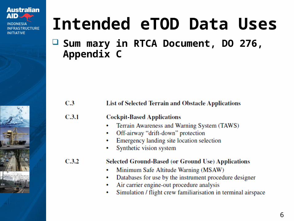
Intended eTOD Data Uses Sum mary in RTCA Document, DO 276,
Appendix C
7
Intended Uses Airborne Databases (ADBs) CNS/ATM
Eg, ADSB / communications coverage Refer EUROCONTROL DEMETER for DME/DME
Assessment Lots of “futures”
They are still to be well defined and specified… But it takes a long time to develop such applications
“Closest” real applications TAWS – eg, EGPWS (terrain only) Obstacles AND Terrain: Flight Procedures
PANS-OPS Procedures: especially for RNAV, RNP, other semi and precision procedures and all PBN (note: may include departures in future)
Engine-out procedures
8
Background to ICAO Standards Developed based on industry and ISO
standards RTCA Docs
200A – Standards for Processing Aeronautical Data 201A – Standards for Aeronautical Information 276 – User Requirements for Terrain and Obstacle Data
ISO 19000 Series for Geographic Information Derived from Open GIS Consortium (OGC) Key standards:
o ISO 19113 (Quality Principles)o ISO 19115 (Metadata)o ISO 19131 (Data Product Specifications
Aviation Standards for Aeronautical Data ICAO Annexes 4, 14, 15 ICAO Doc 9881 Guidelines for Electronic Terrain,
Obstacle and Aerodrome Mapping Info and related FAA and European standards (based on
above)
9
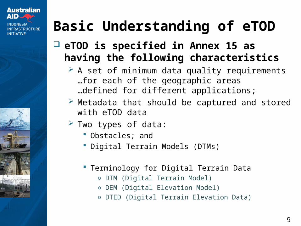
Basic Understanding of eTOD eTOD is specified in Annex 15 as having
the following characteristics A set of minimum data quality requirements
…for each of the geographic areas …defined for different applications;
Metadata that should be captured and stored with eTOD data
Two types of data: Obstacles; and Digital Terrain Models (DTMs)
Terminology for Digital Terrain Datao DTM (Digital Terrain Model)o DEM (Digital Elevation Model)o DTED (Digital Terrain Elevation Data)
10
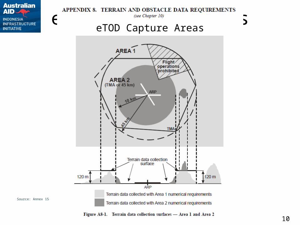
eTOD Capture AreaseTOD Capture Areas
Source: Annex 15
11
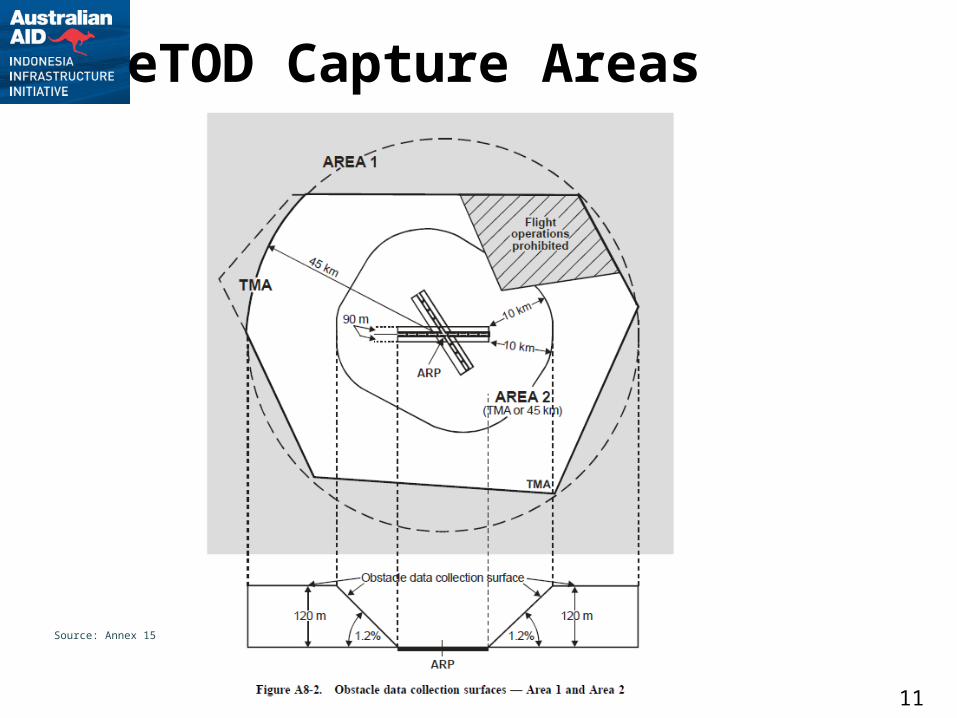
eTOD Capture Areas
Source: Annex 15
12
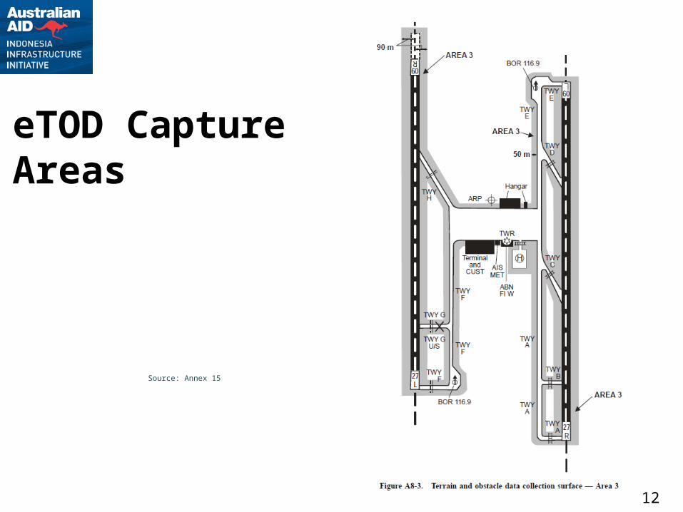
eTOD Capture Areas
Source: Annex 15
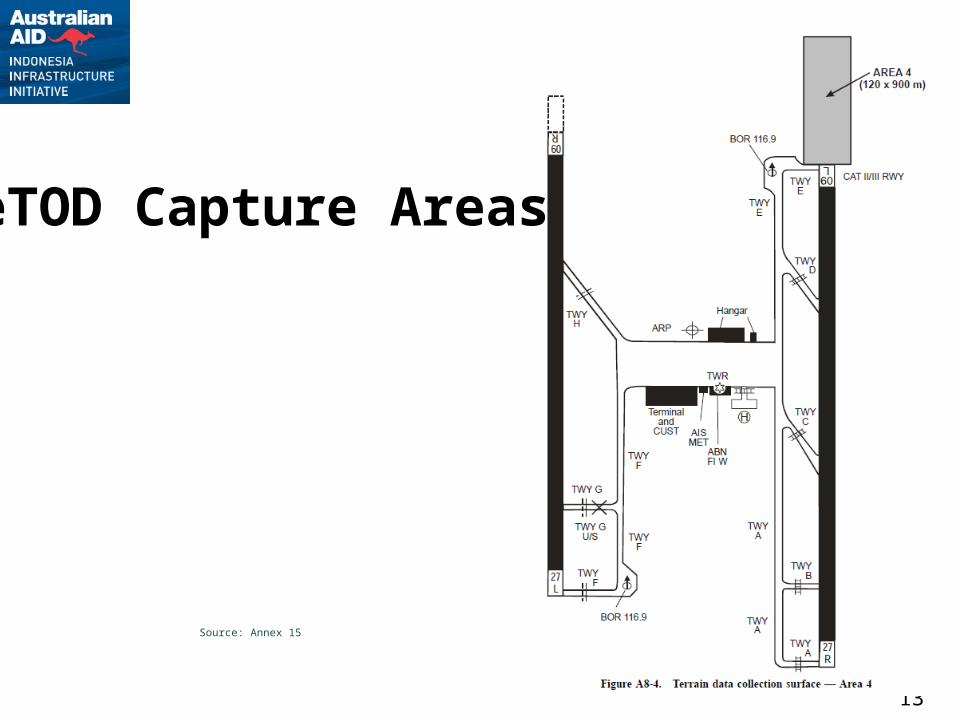
13
eTOD Capture Areas
Source: Annex 15
14
eTOD Status / Issues General Points
Future applications: requirements still vague and not necessarily well understood
Responsibilities & Cost Terrain Data
Data volumes extreme, and costly, to capture and manage
o System capacity and management limitationso How to use productively in existing systemso Capture methods, timelinesso Filtering?
Management of change due to significant natural event (eg, earth quakes, volcanoes, landslides, tsunamis)
15
eTOD Status / Issues General Points
Obstacle Data Cost implications are greatest, particularly with ICAO
requirements for check and update cycles (1, 5 yrs) Handling of data between surveys (eg, proposals,
approvals, construction, non-approved, temporary) Integration with Annex 14 (OLS) requirements ?! Management of change due to significant natural
event.o Main potential implications are where geotechnical shift
has caused displacement - laterally &/or vertically – of key features (eg, runway features) and obstacles
* Note re significant events causing change eTOD: Link to SMS Requirement to check survey Potential NOTAMs, IFP Redesign &/or Revalidation Change Data Quality attributes in DB?
16
eTOD Status in Other Regions Some specific examples
Australia not going to comply for ? years (unspecified)
Regional Implementations EUROCONTROL eTOD Forum (
http://www.eurocontrol.int/aim/public/standard_page/interop_tod_forum.html)o attempts to simplify through 'interpretation'o One recent estimate of costs:
EUR0 0.5m per airport for terrain survey in Area 2o Some countries now have Areas 1 and 4 o Data volumes and management of data a big concern
AFeTOD - Africa - just starting Notice of differences where cannot comply
Country-specific France, Spain, Egypt, etc Refer EUROCONTROL eTOD Forum Exchanges
17
eTOD in Indonesia? Sources and implementation of eTOD for
Indonesia? Use of Publicly Available Terrain Data for
Area 1? Management and consistency across different
agencies? Same Meta data, same handling, same interpretation
Ongoing maintenance and development of eTOD. Need maintenance system and specification, which
incorporates processes for reviewing the maintenance system and the related specifications)
System must include regular schedule for review, etc Ongoing surveys - more than Annex 14 requirements Process for incorporating data inbetween surveys (eg,
approvals, temporary obstacles, unapproved obstacles, etc)
Data improvement — include feedback to data supplier and getting controlled updates