Embed Size (px)
Citation preview
MODIFYING THE BEARS EARS NATIONAL MONUMENT
9681
- - - - - - -
BY THE PRESIDENT OF THE UNITED STATES OF AMERICA
A PROCLAMATION
In Proclamation 9558 of December 28, 2016, and exercising
his authority under section 320301 of title 54, United States
Code (the "Antiquities Act"), President Barack Obama established
the Bears Ears National Monument in the State of Utah, reserving
approximately 1.35 million acres of Federal lands for the care
and management of objects of historic and scientific interest
identified therein. The monument is managed jointly by the
Department of the Interior's Bureau of Land Management (BLM) and
the Department of Agriculture's United States Forest Service
(USFS). This proclamation makes certain modifications to the
monument.
Proclamation 9558 identifies a long list of objects of
historic or scientific interest. It describes cultural
resources such as ancient cliff dwellings (including the Moon
House and Doll House Ruins), Moki Steps, Native American
ceremonial sites, tools and projectile points, remains of
single-family dwellings, granaries, kivas, towers, large
villages, rock shelters, caves, and a prehistoric road system,
as well as petroglyphs, pictographs, and recent rock art left by
the Ute, Navajo, and Paiute peoples. It also identifies other
types of historic objects, such as remnants of Native American
sheep-herding and farming operations and early engineering by
pioneers and settlers, including smoothed sections of rock,
dugways, historic cabins, corrals, trails, and inscriptions
carved into rock, and the Hole-in-the-Rock and Outlaw Trails.
It also describes landscape features such as the Bears Ears,
Comb Ridge, Cedar Mesa, the Valley of the Gods, the Abajo
This document is scheduled to be published in theFederal Register on 12/08/2017 and available online at https://federalregister.gov/d/2017-26709, and on FDsys.gov
2
Mountains, and the San Juan River, and paleontological resources
such as the fossil remains of fishes, amphibians, reptiles, and
mammals, as well as dinosaur trackways and traces of other
terrestrial animals. Finally, it identifies several species,
including animals like the porcupine, badger, and coyote; birds
like the red-tailed hawk, Mexican spotted owl, American kestrel,
and turkey vulture; and plants such as the Fremont cottonwood,
Abajo daisy, western sandbar willow, and boxelder.
The Antiquities Act requires that any reservation of land
as part of a monument be confined to the smallest area
compatible with the proper care and management of the objects of
historic or scientific interest to be protected. Determining
the appropriate protective area involves examination of a number
of factors, including the uniqueness and nature of the objects,
the nature of the needed protection, and the protection provided
by other laws.
Some of the objects Proclamation 9558 identifies are not
unique to the monument, and some of the particular examples of
these objects within the monument are not of significant
scientific or historic interest. Moreover, many of the objects
Proclamation 9558 identifies were not under threat of damage or
destruction before designation such that they required a
reservation of land to protect them. In fact, objects described
in Proclamation 9558 were then -- and still are -- subject to
Federal protections under existing laws and agency management
designations. For example, more than 500,000 acres were already
being managed to maintain, enhance, or protect their roadless
character before they were designated as part of a national
monument. Specifically, the BLM manages approximately 380,759
acres of lands within the existing monument as Wilderness Study
Areas, which the BLM is required by law to manage so as not to
impair their suitability for future congressional designation as
3
Wilderness. On lands managed by the USFS, 46,348 acres are part
of the congressionally designated Dark Canyon Wilderness Area,
which, under the 1964 Wilderness Act, 16 U.S.C. 1131-1136, and
the Utah Wilderness Act of 1984, Public Law 98-428, the USFS
must manage so as to maintain or enhance its wilderness
character. Approximately 89,396 acres of the USFS lands are
also included in 8 inventoried roadless areas, which are managed
under the USFS's 2001 Roadless Rule so as to protect their
wilderness character.
A host of laws enacted after the Antiquities Act provide
specific protection for archaeological, historic, cultural,
paleontological, and plant and animal resources and give
authority to the BLM and USFS to condition permitted activities
on Federal lands, whether within or outside a monument. These
laws include the Archaeological Resources Protection Act of
1979, 16 U.S.C. 470aa-470mm, National Historic Preservation Act,
54 U.S.C. 300101 et seq., Bald and Golden Eagle Protection Act,
16 U.S.C. 668-668d, Endangered Species Act of 1973, 16 U.S.C.
1531 et seq., Federal Cave Resources Protection Act of 1988, 16
U.S.C. 4301 et seq., Federal Land Policy and Management Act of
1976, 43 U.S.C. 1701 et seq., Migratory Bird Treaty Act, 16
U.S.C. 703-712, National Forest Management Act, 16 U.S.C. 1600
et seq., Native American Graves Protection and Repatriation Act
of 1976, 25 U.S.C. 3001 et seq., and Paleontological Resources
Preservation Act, 16 U.S.C. 470aaa-470aaa-11. Of particular
note, the Archaeological Resources Protection Act specifically
protects archaeological resources from looting or other
desecration and imposes criminal penalties for unauthorized
excavation, removal, damage, alteration, or defacement of
archaeological resources. Federal land management agencies can
grant a permit authorizing excavation or removal, but only when
undertaken for the purpose of furthering archaeological
4
knowledge. The Paleontological Resources Preservation Act
contains very similar provisions protecting paleontological
resources. And the Migratory Bird Treaty Act and Endangered
Species Act protect migratory birds and listed endangered and
threatened species and their habitats. Moreover, the BLM and
the USFS were already addressing many of the threats to objects
identified in Proclamation 9558 in their governing land-use
plans before designation of the monument.
Given the nature of the objects identified on the lands
reserved by Proclamation 9558, the lack of a threat of damage or
destruction to many of those objects, and the protection for
those objects already provided by existing law and governing
land-use plans, I find that the area of Federal land reserved in
the Bears Ears National Monument established by Proclamation
9558 is not confined to the smallest area compatible with the
proper care and management of those objects. The important
objects of scientific or historic interest can instead be
protected by a smaller and more appropriate reservation of 2
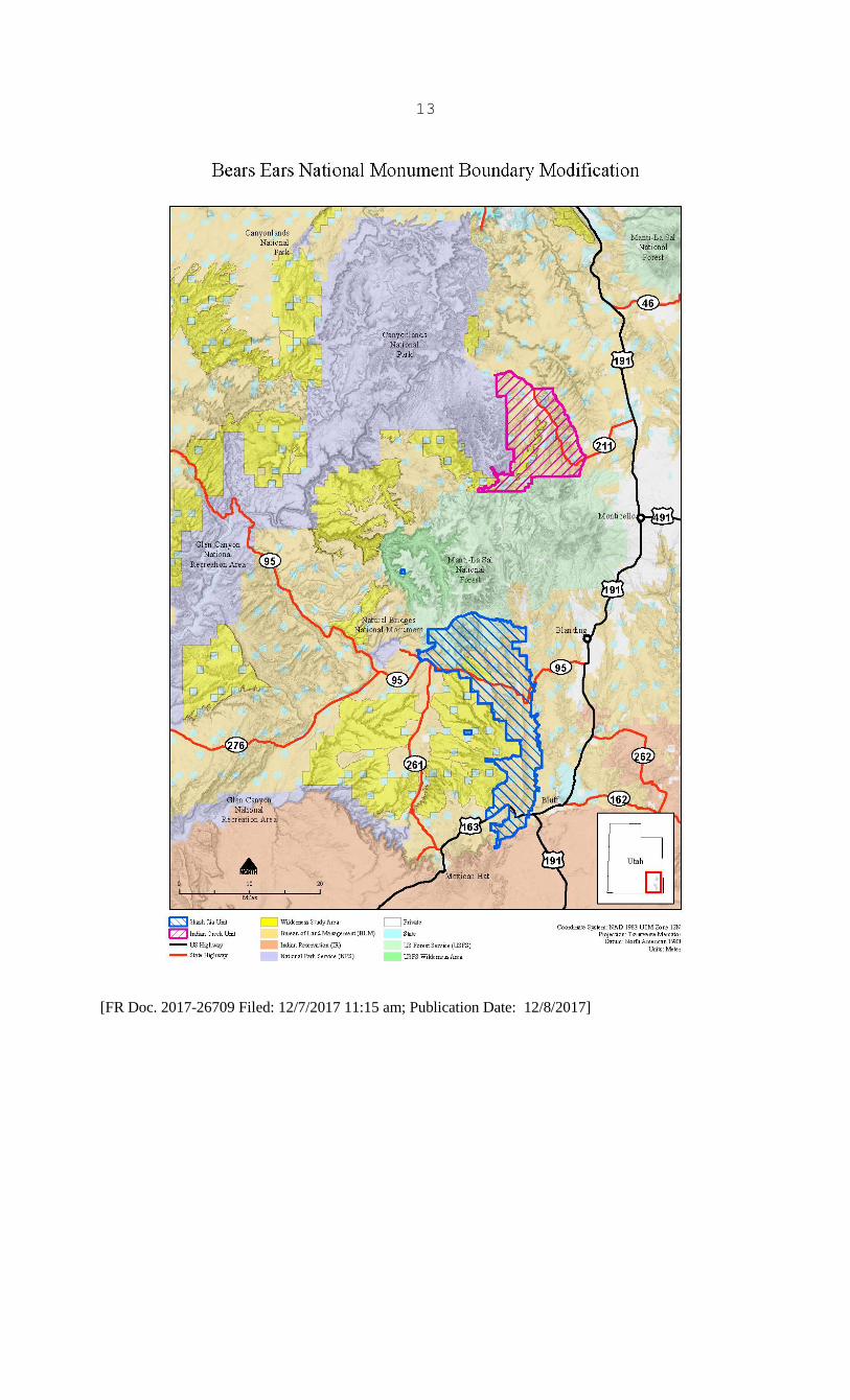
areas: Shash Jáa and Indian Creek. Revising the boundaries of
the monument to cover these 2 areas will ensure that, in
accordance with the Antiquities Act, it is no larger than
necessary for the proper care and management of the objects to
be protected within the monument.
The Shash Jáa area contains the heart of the national
monument: the iconic twin buttes known as the Bears Ears that
tower 2,000 feet above the surrounding landscape and are
considered sacred to the Native American tribes that call this
area their ancestral home. Many of the significant objects
described by Proclamation 9558 can be found throughout the Shash
Jáa area. Ancestral Puebloan occupation of the area began
during the Basketmaker II period at least 2,500 years ago, and
it left behind objects such as pit houses, storage pits, lithic
5
scatters, campsites, rock shelters, pictographs, and baskets, as
well as manos and metates for grinding corn. Occupation dating
to the Basketmaker III period, from approximately 500 to 750
C.E., left additional evidence of maize- and bean-based
agriculture, along with pottery, bows and arrows, pit houses,
kivas, storage rooms, and dispersed villages.
New waves of human settlement occurred around 900 C.E.,
when the Pueblo I period gave rise to large villages near Comb
Wash, and 1050 C.E., when inhabitants from the Pueblo II period
built expansive and complex multi-family dwellings. Around 1150
C.E., the dawn of the Pueblo III period, the area's inhabitants
increasingly sought shelter in cliff dwellings and left behind
evidence of an era of unrest. Several centuries later, the Ute,
Paiute, and Navajo came to occupy the area.
East of the Bears Ears is Arch Canyon, within which
paleontologists have found numerous fossils from the Permian and
Upper Permian eras. Cliff dwellings are hidden throughout the
canyon, and the mouth of the canyon holds the fabled Arch Canyon
ruin, which spans the Pueblo II and III periods and contains
pictographs and petroglyphs ranging from the Archaic to the
historic periods.
Just south of Arch Canyon are the north and south forks of
Mule Canyon. Five-hundred feet deep, 5 miles long, and
decorated with alternating layers of red and white sandstone,
these 2 striking canyons contain shelter-cliff dwellings and
other archaeological sites, including the scenic and accessible
House on Fire Ruin, which includes differing masonry styles that
indicate several episodes of construction and use.
Perched high on the open tablelands above the south fork of
Mule Canyon are the Mule Canyon ruins, where visitors can see
exposed masonry walls of ancient living quarters and a partially
restored kiva. The deep canyons and towering mesas of the Shash
6
Jáa area are full of similar sites, including rock art, remains
of single-family dwellings, granaries, kivas, towers (including
the Cave Towers), and large villages primarily from the Pueblo
II and III periods, along with sites from the Basketmaker and
Archaic periods.
The Shash Jáa area also includes Comb Ridge, a north-south
trending monocline that originates near the boundary of the
Manti-La Sal National Forest, ends near the San Juan River, and
contains remnants from the region's thousands of years of human
habitation, including cliff dwellings, granaries, kivas,
ceremonial sites, and the Butler Wash ruin, a world-famous
Ancestral Puebloan ruin with multiple rooms and kivas. Comb
Ridge also includes world-class examples of ancient rock art,
such as the Butler Wash Kachina Panel, a wall-sized mural of San
Juan Anthropomorph figures that dates to the Basketmaker period
and is considered to be one of the Southwest's most important
petroglyph panels for understanding the daily life and rituals
of the Basketmaker people. Significant fossil sites have also
been discovered in Butler Wash.
Just north of upper Butler Wash, the aspen-filled Whiskers
Draw contains a series of alcoves that have sheltered evidence
of human habitation for thousands of years, including Cave 7,
the site where Richard Wetherill, as part of the Hyde Expedition
in 1893, first identified what we know today as the Basketmaker
people. The nearby Milk Ranch Point is home to a rich
concentration of kivas, granaries, dwellings, and other evidence
that Pueblo I farmers used this area to cultivate corn, beans,
and squash.
The Shash Jáa area also contains the Comb Ridge Fossil
site, which includes a trackway created by a giant arthropod
(Diplichnites cuithensis), the first recorded instance of such a
trackway in Utah. Also, the diverse landscape of the Shash Jáa
7
area provides habitat for the vast majority of plant and animal
species described by Proclamation 9558.
Finally, the Shash Jáa area as described on the
accompanying map includes 2 non-contiguous parcels of land that
encompass the Moon House Ruin, an example of iconic
Pueblo-decorated architecture, which was likely the last
occupied site on Cedar Mesa, as well as Doll House Ruin, a fully
intact and well-preserved single room granary that is associated
with an extensive agricultural area on the mesa top. These
significant ruins are important examples of cultural resource
objects that should remain within the monument's boundaries.
The Indian Creek area likewise contains objects of
significance described in Proclamation 9558. At its center is
the broad Indian Creek Canyon, which is characterized by sheer
red cliffs and spires of exposed and eroded layers of Navajo,
Kayenta, Wingate, and Cedar Mesa sandstone, including the iconic
North and South Six-Shooter Peaks.
Also located within the Indian Creek area is the
Canyonlands Research Center. Spanning lands managed by the
National Park Service, BLM, USFS, and private landowners, this
unique partnership works to increase our understanding of the
complex natural systems on the landscape, providing their
custodians with information they need to adapt to the challenges
of a changing Colorado Plateau.
Newspaper Rock, a popular attraction in the Indian Creek
area, is a roadside rock art panel that has been listed on the
National Register of Historic Places since 1976. This site
displays a significant concentration of rock art from multiple
periods, etched into Wingate sandstone. The older art is
attributed to the Ancestral Puebloan people who inhabited this
region for 2,000 years, while the more recent rock art is
8
attributed to the Ute people who still live in the Four Corners
area.
In addition to Newspaper Rock, the Indian Creek area
contains numerous other significant rock art sites, including
the distinctive and well-preserved petroglyphs in Shay Canyon.
The area also provides opportunities for cultural and scientific
research and paleontological study. Dinosaur tracks in the
bottom of the Shay Canyon stream bed are a unique visual
reminder of the area's distant past. Additional paleontological
resources can be found throughout the Indian Creek area,
including vertebrate and invertebrate fossils, primarily in the
Chinle Formation. The Indian Creek area also includes 2
prominent mesas, Bridger Jack Mesa and Lavender Mesa, which are
home to relict plant communities, predominantly composed of
pinyon-juniper woodland, with small, interspersed sagebrush
parks, that exist only on these isolated islands in the desert
sea and are, generally, unaltered by humans. These mesas
provide the opportunity for comparative studies of
pinyon-juniper woodland and sagebrush communities in other parts
of the Colorado Plateau. Additionally, the Indian Creek area
includes the exposed Chinle Formation, known for abundant
fossilized flora and fauna, including pelecypods, gastropods,
arthropods, fishes, amphibians, and reptiles (including
dinosaurs). Finally, the area is well known for vertebrate
trackways, including tetrapod footprints.
Some of the existing monument's objects, or certain
examples of those objects, are not within the monument's revised
boundaries because they are adequately protected by existing
law, designation, agency policy, or governing land-use plans.
For example, although the modified boundaries do not include the
San Juan River or the Valley of the Gods, both of those areas
are protected by existing administratively designated Areas of
9
Critical Environmental Concern. Plant and animal species such
as the bighorn sheep, the Kachina daisy, the Utah night lizard,
and the Eucosma navojoensis moth are protected by the Endangered
Species Act and existing land-use plans and policies protecting
special-status species. Additionally, some of the range of
these species falls within existing Wilderness Areas and
Wilderness Study Areas. Finally, although Hideout Canyon is
likewise not included within the modified boundaries, it is
generally not threatened and is partially within a Wilderness
Study Area.
The areas described above are the smallest compatible with
the protection of the important objects identified in
Proclamation 9558. The modification of the Bears Ears National
Monument will maintain and protect those objects and preserve
the area's cultural, scientific, and historic legacy.
WHEREAS, Proclamation 9558 of December 28, 2016, designated
the Bears Ears National Monument in the State of Utah and
reserved approximately 1.35 million acres of Federal lands for
the care and management of the Bears Ears buttes and other
objects of historic and scientific interest identified therein;
and
WHEREAS, many of the objects identified by Proclamation
9558 are otherwise protected by Federal law; and
WHEREAS, it is in the public interest to modify the
boundaries of the monument to exclude from its designation and
reservation approximately 1,150,860 acres of land that I find
are unnecessary for the care and management of the objects to be
protected within the monument; and
WHEREAS, the boundaries of the monument reservation should
therefore be reduced to the smallest area compatible with the
protection of the objects of scientific or historic interest as
described above in this proclamation;
10
NOW, THEREFORE, I, DONALD J. TRUMP, President of the
United States of America, by the authority vested in me by
section 320301 of title 54, United States Code, hereby proclaim
that the boundaries of the Bears Ears National Monument are
hereby modified and reduced to those lands and interests in land
owned or controlled by the Federal Government within the
boundaries described on the accompanying map, which is attached
to and forms a part of this proclamation. I hereby further
proclaim that the modified monument areas identified on the
accompanying map shall be known as the Indian Creek and Shash
Jáa units of the monument, the latter of which shall include the
Moon House and Doll House Ruins. These reserved Federal lands
and interests in lands cumulatively encompass approximately
201,876 acres. The boundaries described on the accompanying map
are confined to the smallest area compatible with the proper
care and management of the objects to be protected. Any lands
reserved by Proclamation 9558 not within the boundaries
identified on the accompanying map are hereby excluded from the
monument.
At 9:00 a.m., eastern standard time, on the date that is 60
days after the date of this proclamation, subject to valid
existing rights, the provisions of existing withdrawals, and the
requirements of applicable law, the public and National Forest
System lands excluded from the monument reservation shall be
open to:
(1) entry, location, selection, sale, or other
disposition under the public land laws and laws
applicable to the U.S. Forest Service;
(2) disposition under all laws relating to mineral
and geothermal leasing; and
(3) location, entry, and patent under the mining
laws.
11
Appropriation of lands under the mining laws before the
date and time of restoration is unauthorized. Any such
attempted appropriation, including attempted adverse possession
under 30 U.S.C. 38, shall vest no rights against the United
States. Acts required to establish a location and to initiate a
right of possession are governed by State law where not in
conflict with Federal law.
Nothing in this proclamation shall be construed to remove
any lands from the Manti-La Sal National Forest or to otherwise
revoke, modify, or affect any withdrawal, reservation, or
appropriation, other than the one created by Proclamation 9558.
Nothing in this proclamation shall change the management of
the areas designated and reserved by Proclamation 9558 that
remain part of the monument in accordance with the terms of this
proclamation, except as provided by the following 4 paragraphs:
In recognition of the importance of tribal participation to
the care and management of the objects identified above, and to
ensure that management decisions affecting the monument reflect
tribal expertise and traditional and historical knowledge,
Proclamation 9558 established a Commission to provide guidance
and recommendations on the development and implementation of
management plans and on management of the monument, and to
partner with Federal agencies by making continuing contributions
to inform decisions regarding the management of the monument.
In order to ensure that the full range of tribal expertise and
traditional historical knowledge is included in such guidance
and recommendations, paragraph 29 of Proclamation 9558 is hereby
revised to provide that the Bears Ears Commission shall be known
as the Shash Jáa Commission, shall apply only to the Shash Jáa
unit as described herein, and shall also include the elected
officer of the San Juan County Commission representing District
3 acting in that officer's official capacity.
12
Proclamation 9558 is hereby revised to clarify that,
pending preparation of the transportation plan required by
paragraph 34 thereof, the Secretaries of the Interior and
Agriculture may allow motorized and non-mechanized vehicle use
on roads and trails designated for such use immediately before
the issuance of Proclamation 9558 and maintain roads and trails
for such use.
Paragraph 35 of Proclamation 9558 governing livestock
grazing in the monument is hereby revised to read as follows:
"Nothing in this proclamation shall be deemed to affect
authorizations for livestock grazing, or administration thereof,
on Federal lands within the monument. Livestock grazing within
the monument shall continue to be governed by laws and
regulations other than this proclamation."
Proclamation 9558 is amended to clarify that, consistent
with the care and management of the objects identified above,
the Secretaries of the Interior and Agriculture may authorize
ecological restoration and active vegetation management
activities in the monument.
If any provision of this proclamation, including its
application to a particular parcel of land, is held to be
invalid, the remainder of this proclamation and its application
to other parcels of land shall not be affected thereby.
IN WITNESS WHEREOF, I have hereunto set my hand this
fourth day of December, in the year of our Lord
two thousand seventeen, and of the Independence of the
United States of America the two hundred and forty-second.
13
[FR Doc. 2017-26709 Filed: 12/7/2017 11:15 am; Publication Date: 12/8/2017]