Embed Size (px)
Citation preview
Modified SWAT Model for Modified SWAT Model for Cold Climate of CanadaCold Climate of Canada
Application: Rouge RiverRouge River Watershed
Masoud AsadzadehMasoud AsadzadehWanhong Yang & Yongbo LiuLuis Leon & William BootyRam Yerubandi , Craig McCrimmon, Issac Wong, and Phil Fong
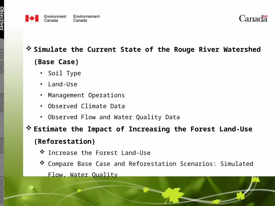
Simulate the Current State of the Rouge River Watershed (Base Case)
• Soil Type
• Land-Use
• Management Operations
• Observed Climate Data
• Observed Flow and Water Quality Data
Estimate the Impact of Increasing the Forest Land-Use (Reforestation)
Increase the Forest Land-Use
Compare Base Case and Reforestation Scenarios: Simulated Flow, Water Quality
Ob
jectiv
es
Case S
tud
yM
eth
od
sR
esu
ltsC
on
clu
sio
ns
Rouge River WatershedRouge River Watershed
Ob
jectiv
es
Case S
tud
yM
eth
od
sR
esu
ltsC
on
clu
sio
ns
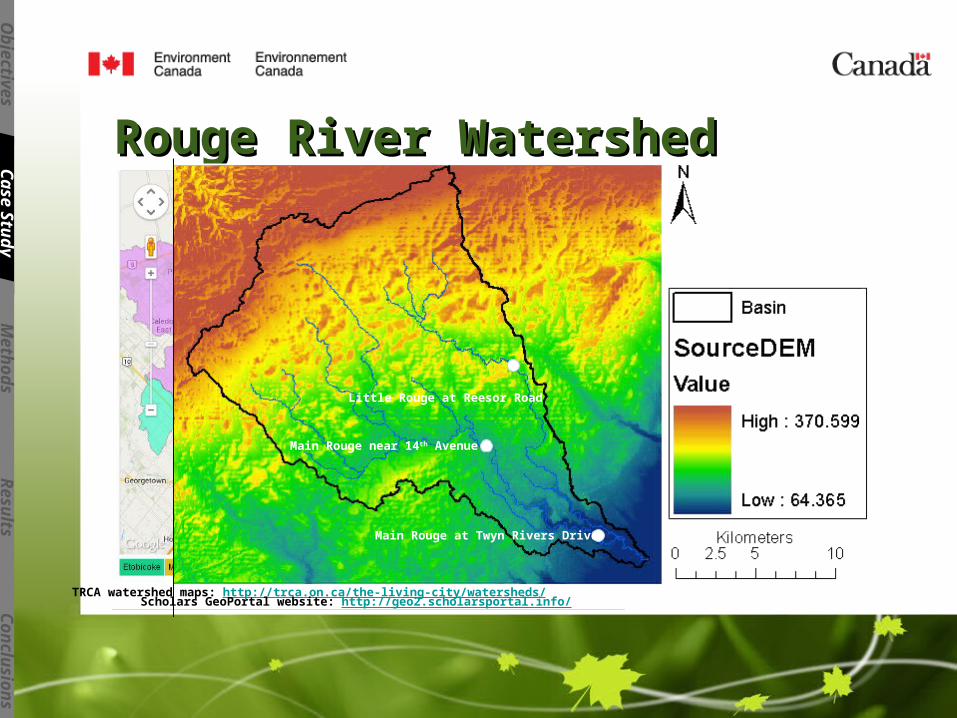
TRCA watershed maps: http://trca.on.ca/the-living-city/watersheds/ Scholars GeoPortal website: http://geo2.scholarsportal.info/
Little Rouge at Reesor Road
Main Rouge near 14th Avenue
Main Rouge at Twyn Rivers Drive
Rouge River WatershedRouge River Watershed
Ob
jectiv
es
Case S
tud
yM
eth
od
sR
esu
ltsC
on
clu
sio
ns
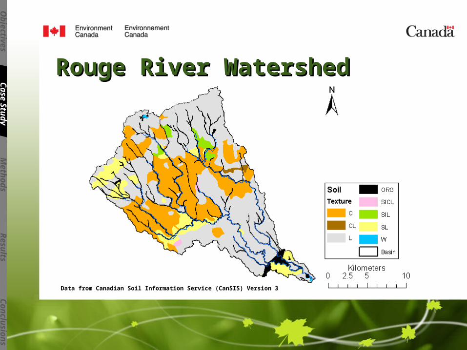
Data from Canadian Soil Information Service (CanSIS) Version 3
Rouge River WatershedRouge River Watershed
Ob
jectiv
es
Case S
tud
yM
eth
od
sR
esu
ltsC
on
clu
sio
ns
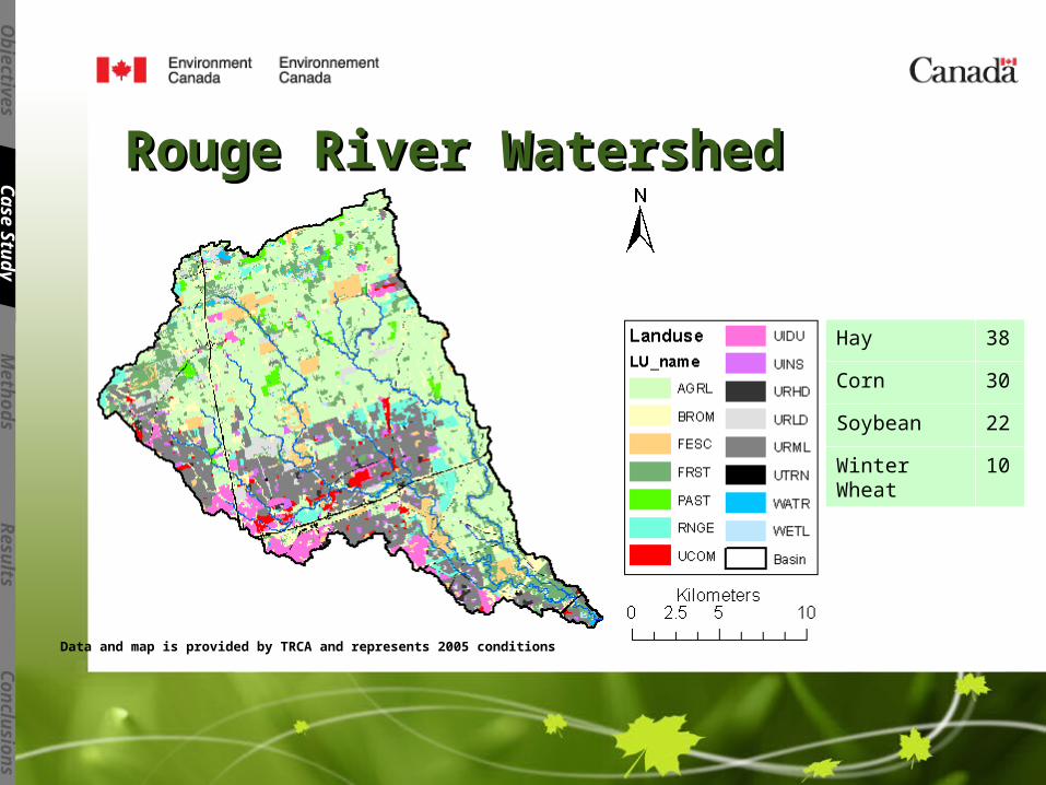
Data and map is provided by TRCA and represents 2005 conditions
Hay 38
Corn 30
Soybean 22
Winter Wheat 10
CanSWATCanSWATSnow Redistribution:Snow Redistribution:Snow can redistribute between land-use classes based on:
•Wind direction
•Slope and curvature along the wind direction
•Elevation
Snowmelt under Frozen Soil Condition:Snowmelt under Frozen Soil Condition:•Modified CNfrz based on SW of each layer of the soil
•Added soil erodibility factor for snowmelt events
•Added user defined nutrient enrichment ratios, nitrate percolation coefficient, and P soil partitioning coefficient for snowmelt events.
Ob
jectiv
es
Case S
tud
yM
eth
od
sR
esu
ltsC
on
clu
sio
ns
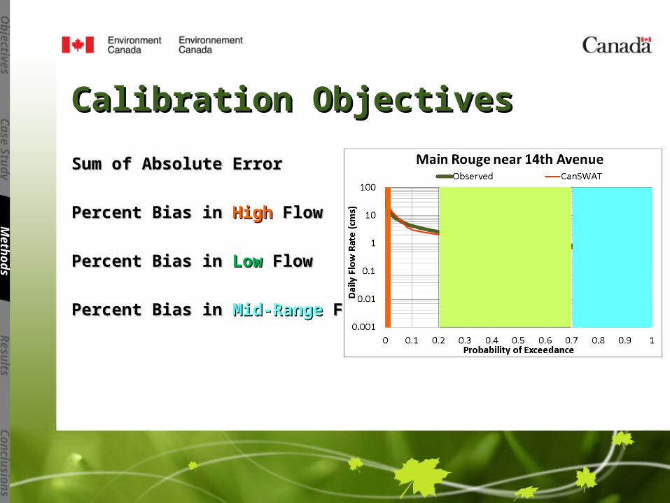
Calibration ObjectivesCalibration Objectives
Sum of Absolute ErrorSum of Absolute Error
Percent Bias in Percent Bias in HighHigh Flow Flow
Percent Bias in Percent Bias in LowLow Flow Flow
Percent Bias in Percent Bias in Mid-RangeMid-Range Flow Flow
Ob
jectiv
es
Case S
tud
yM
eth
od
sR
esu
ltsC
on
clu
sio
ns
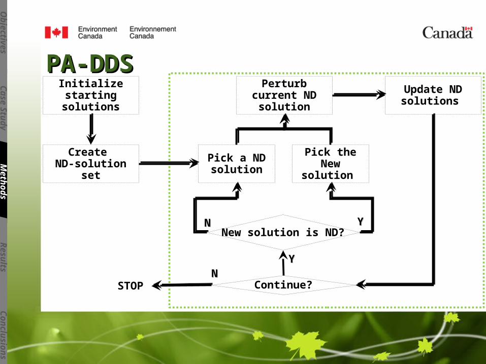
PA-DDSPA-DDS
Ob
jectiv
es
Case S
tud
yM
eth
od
sR
esu
ltsC
on
clu
sio
ns
Perturb current ND solution
Update ND solutions
Continue?STOP
New solution is ND?
Pick the New solution
Pick a ND solution
Initialize starting solutions
YYNN
Create ND-solution set
YYNN
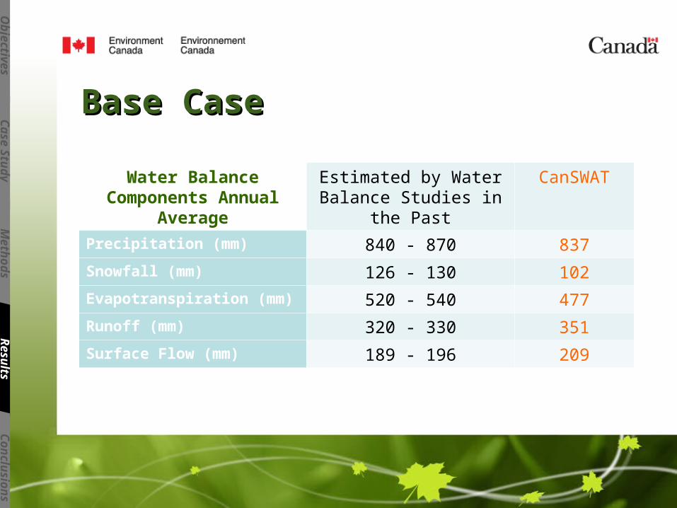
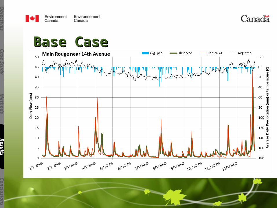
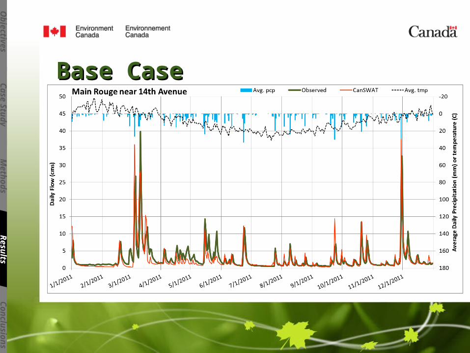
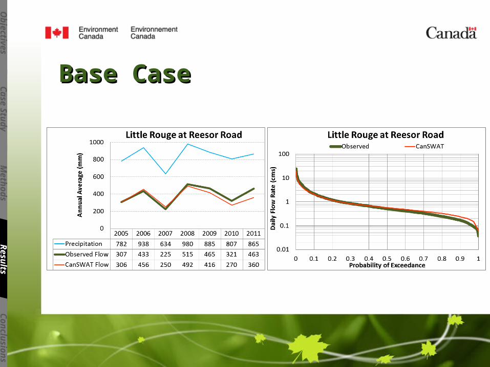
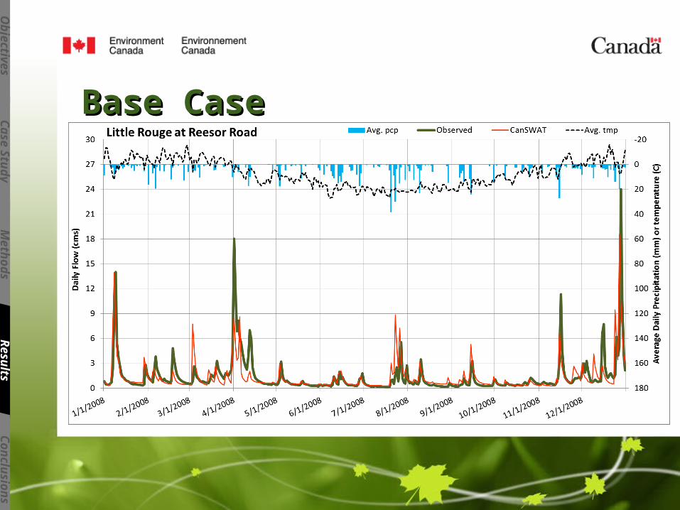
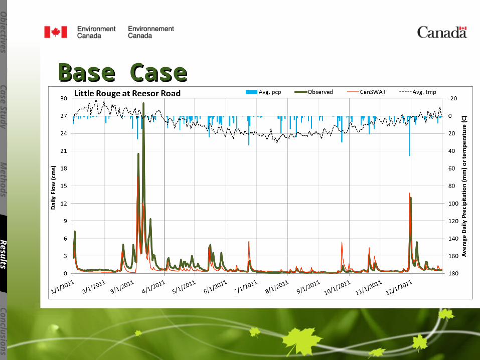
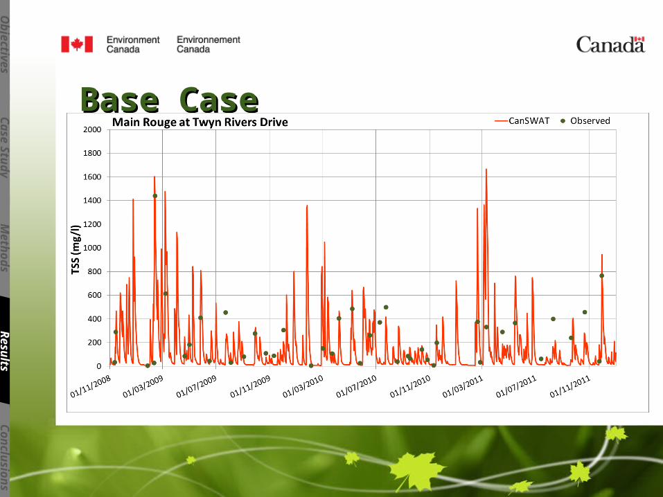
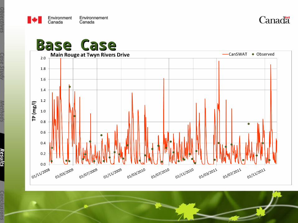
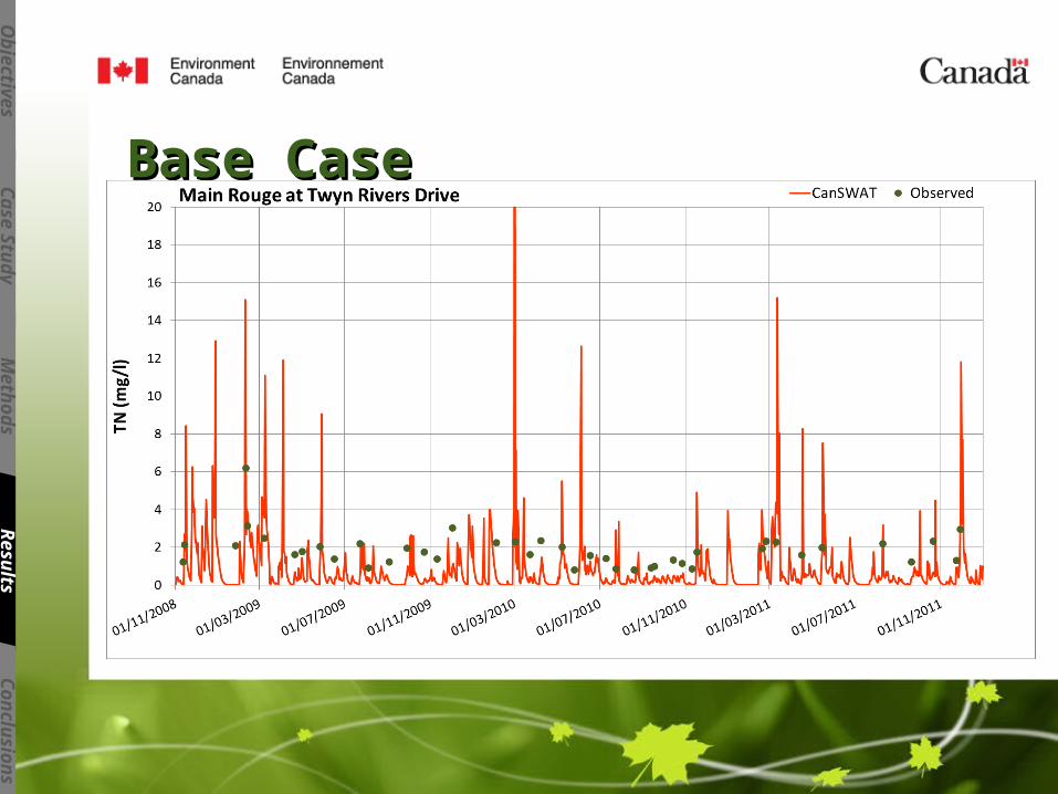
Base CaseBase Case
Water Balance Components Annual Average
Estimated by Water Balance Studies in the Past
CanSWAT
Precipitation (mm) 840 - 870 837
Snowfall (mm) 126 - 130 102
Evapotranspiration (mm) 520 - 540 477
Runoff (mm) 320 - 330 351
Surface Flow (mm) 189 - 196 209
Ob
jectiv
es
Case S
tud
yM
eth
od
sR
esu
ltsC
on
clu
sio
ns
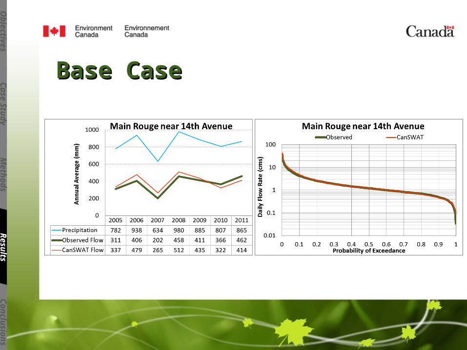
Base CaseBase Case
Ob
jectiv
es
Case S
tud
yM
eth
od
sR
esu
ltsC
on
clu
sio
ns
Base CaseBase Case
Ob
jectiv
es
Case S
tud
yM
eth
od
sR
esu
ltsC
on
clu
sio
ns
Base CaseBase Case
Ob
jectiv
es
Case S
tud
yM
eth
od
sR
esu
ltsC
on
clu
sio
ns
Base CaseBase Case
Ob
jectiv
es
Case S
tud
yM
eth
od
sR
esu
ltsC
on
clu
sio
ns
Base CaseBase Case
Ob
jectiv
es
Case S
tud
yM
eth
od
sR
esu
ltsC
on
clu
sio
ns
Base CaseBase Case
Ob
jectiv
es
Case S
tud
yM
eth
od
sR
esu
ltsC
on
clu
sio
ns
Base CaseBase Case
Ob
jectiv
es
Case S
tud
yM
eth
od
sR
esu
ltsC
on
clu
sio
ns
Base CaseBase Case
Ob
jectiv
es
Case S
tud
yM
eth
od
sR
esu
ltsC
on
clu
sio
ns
Base CaseBase Case
Ob
jectiv
es
Case S
tud
yM
eth
od
sR
esu
ltsC
on
clu
sio
ns
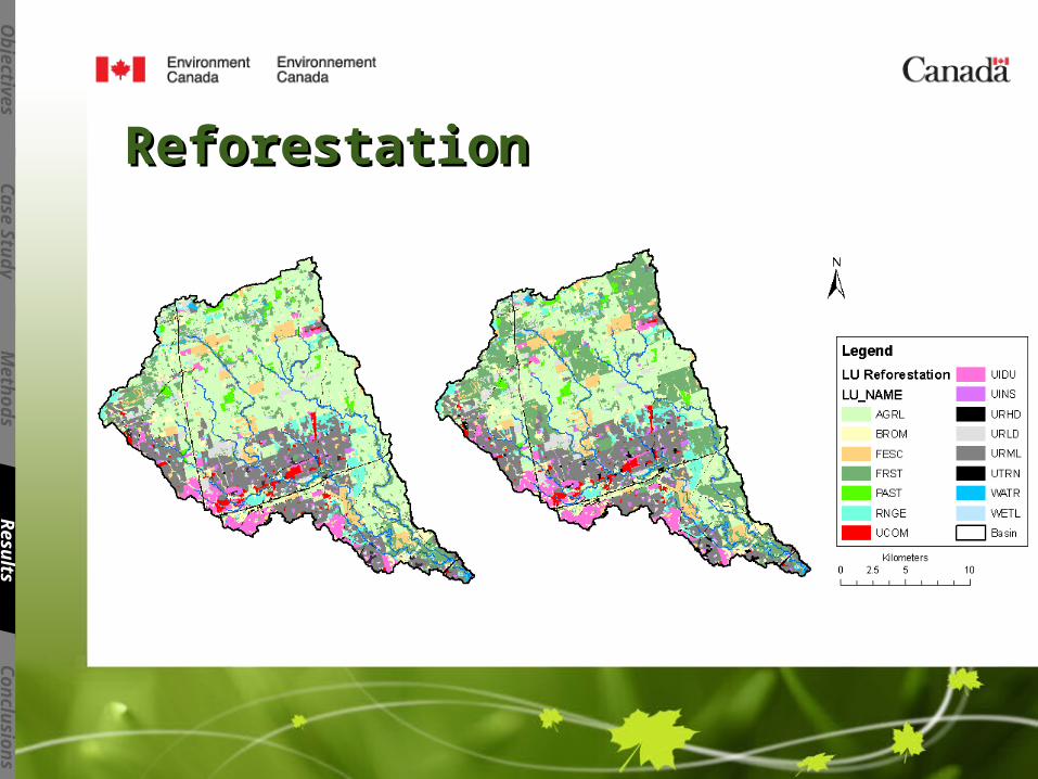
ReforestationReforestation
Ob
jectiv
es
Case S
tud
yM
eth
od
sR
esu
ltsC
on
clu
sio
ns
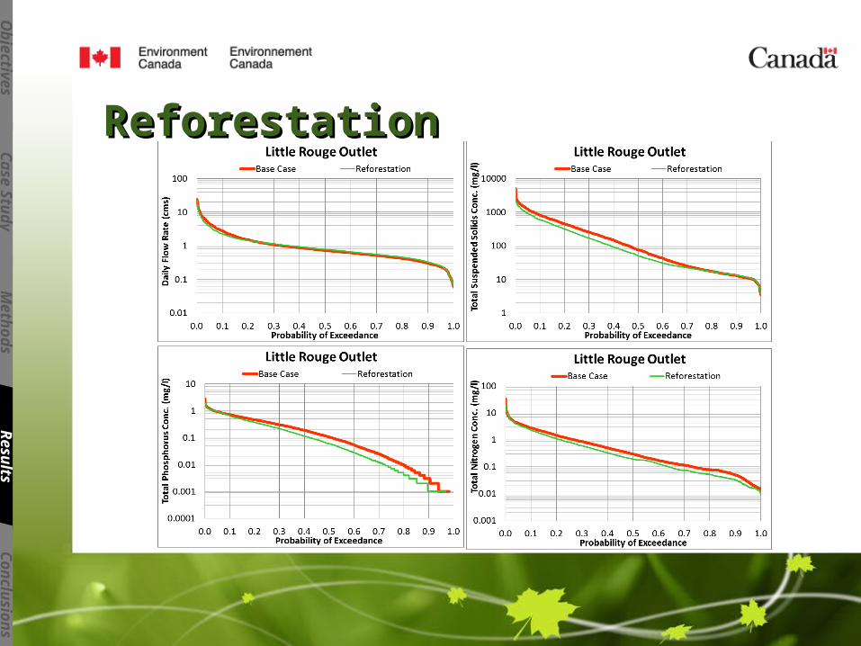
ReforestationReforestation
Ob
jectiv
es
Case S
tud
yM
eth
od
sR
esu
ltsC
on
clu
sio
ns
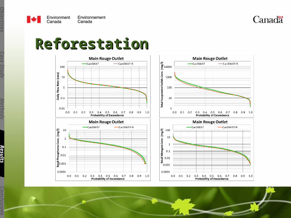
ReforestationReforestation
Ob
jectiv
es
Case S
tud
yM
eth
od
sR
esu
ltsC
on
clu
sio
ns
ReforestationReforestation
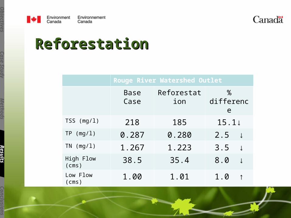
Rouge River Watershed Outlet
Base Case Reforestation % differenceTSS (mg/l) 218 185 15.1↓↓TP (mg/l) 0.287 0.280 2.5 ↓↓TN (mg/l) 1.267 1.223 3.5 ↓↓High Flow (cms) 38.5 35.4 8.0 ↓↓Low Flow (cms) 1.00 1.01 1.0 ↑↑
Ob
jectiv
es
Case S
tud
yM
eth
od
sR
esu
ltsC
on
clu
sio
ns
Rouge River watershed is modelled with detailed information about the soil type, land-
use, and land management operations.
CanSWAT is calibrated to adequately simulate flow and water quality constituents.
The calibrated model is a good representation of the rainfall-runoff relationship in the
Rouge River watershed.
Reforestation can reduce sediments and nutrients delivered into the Lake Ontario from
the watershed.
Ob
jectiv
es
Case S
tud
yM
eth
od
sR
esu
ltsC
on
clu
sio
ns

Thank YouThank You
Ob
jectiv
es
Case S
tud
yM
eth
od
sR
esu
ltsC
on
clu
sio
ns