Embed Size (px)
Citation preview

Modelling and Data Assimilation
With
Remote Sensing and Oznet data
Robert Pipunic
Dept. of Infrastructure Engineering, The University of
Melbourne
Acknowledgements: Jeff Walker, Gabrielle DeLannoy,
Andrew Western, Matt McCabe, Rodger Young, Clara Draper,
CSIRO (Marine and Atmospheric Research, Land and
Water), DPI Victoria.
5th NAFE Workshop, Monash Uni, 23-25th Feb 2011

Data Assimilation – Remote sensing, Oznet
Overview
• Motivation
• CABLE model/DA approach
• Experiments with remote sensing data for Kyeamba
Creek and Yanco
• conclusions and issues identified

Data Assimilation – Remote sensing, Oznet
Motivation
• Data assimilation combines measurements and models for better
hydrologic predictions on denser time-scales
• Research is required to maximise benefits for particular
environments, data types, models
• Data assimilation has not been thoroughly tested with CABLE
model (to be used in Australia’s weather prediction system)
• Oznet provides opportunity for validating model/DA output and
remote sensing data.

Data Assimilation – Remote sensing, Oznet
CABLE & Specs Relevant to Assimilation • Model forced at each time step by:
• Incoming short wave and long wave radiation;
• Air temperature;
• Rainfall;
• Wind speed;
• Specific humidity;
• Air pressure.
• Energy/water exchanges for vegetation and soil surfaces
• Soil Moisture and soil temperature for 6 soil layers are the
prognostic state variables
• Traditional state updating applied with assimilation – no parameter optimisation.

Ensemble Kalman Filter (EnKF) used:
Data Assimilation – Remote sensing, Oznet
• Ensembles of inputs used Initial conditions, and forcing time
series data (eg. Turner et al., 2008)
• Results in ensemble of model predictions for error covariance calculations
• Model structure uncertainty not specifically treated, model or
observation bias not addressed
• Observation ensembles normally distributed random
perturbations added to observation value
Data Assimilation – Remote sensing, Oznet
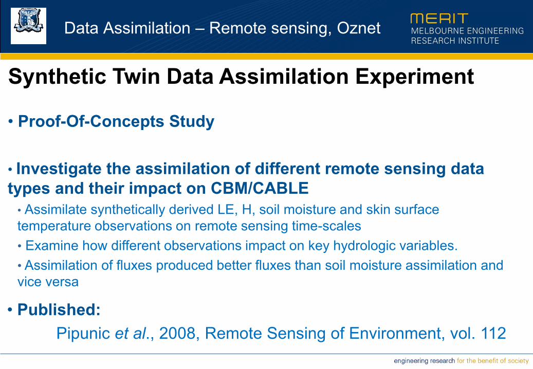
Synthetic Twin Data Assimilation Experiment
• Proof-Of-Concepts Study
• Investigate the assimilation of different remote sensing data
types and their impact on CBM/CABLE
• Assimilate synthetically derived LE, H, soil moisture and skin surface
temperature observations on remote sensing time-scales
• Examine how different observations impact on key hydrologic variables.
• Assimilation of fluxes produced better fluxes than soil moisture assimilation and
vice versa
• Published:
Pipunic et al., 2008, Remote Sensing of Environment, vol. 112
Data Assimilation – Remote sensing, Oznet
One-D Field Data Assimilation Experiment • Follow on from Synthetic-twin study, but with real field
observations at point scale
• Assimilated into CABLE on remote sensing time-scales
• Reinforced synthetic findings about CABLE flux
observations improved modelled fluxes best, surface soil
moisture observations improve surface soil moisture best
• Highlighted limitations with the model.
• Submitted for Review
Pipunic et al., 2011, to Remote Sensing of Environment

Data Assimilation – Remote sensing, Oznet
Kyeamba Creek – modelling/DA
• Shallowest surface
moisture obs are 5-7cm
• profile observations are in
30cm intervals to 90cm
• Assimilated surface soil
moisture product from
AMSR-E (Owe et al., 2008)

Data Assimilation – Remote sensing, Oznet
Kyeamba Creek – modelling/DA
• Assimilated surface soil moisture product from AMSR-E (Owe et al.,
2008) provided on 25km resolution grid
• Observation is ~1-2cm of soil depth assimilated into CABLE’s top
soil layer (2.2cm thick) once daily with ~2am local overpass observation
• Model simulation run at 5km resolution over a single 25km AMSR-E
pixel domain Used a single set of forcing data, soil parameters from
detailed regional mapping, LAI 1km x 1km resolution derived from
AVHRR fPAR data

Data Assimilation – Remote sensing, Oznet
Kyeamba Creek – modelling domain
a) Available surface moisture b) Available root zone (0-60cm)
Moisture

Data Assimilation – Remote sensing, Oznet
K1
0.00
0.05
0.10
0.15
0.20
0.25
0.30
0.35
0.40
0.45
0.50
Ju
l-05
Au
g-0
5
Se
p-0
5
Oct-0
5
No
v-0
5
De
c-0
5
So
il M
ois
ture
(v
ol/
vo
l)
K2
0.00
0.05
0.10
0.15
0.20
0.25
0.30
0.35
0.40
0.45
0.50
Ju
l-05
Au
g-0
5
Se
p-0
5
Oct-0
5
No
v-0
5
De
c-0
5
So
il M
ois
ture
(v
ol/v
ol)
K3
0.00
0.05
0.10
0.15
0.20
0.25
0.30
0.35
0.40
0.45
0.50
Ju
l-05
Au
g-0
5
Se
p-0
5
Oct-0
5
No
v-0
5
De
c-0
5
So
il M
ois
ture
(v
ol/v
ol)
K4
0.00
0.05
0.10
0.15
0.20
0.25
0.30
0.35
0.40
0.45
0.50
Ju
l-05
Aug-0
5
Sep-0
5
Oct-0
5
No
v-0
5
De
c-0
5
So
il M
ois
ture
(v
ol/
vo
l)
K5
0.00
0.05
0.10
0.15
0.20
0.25
0.30
0.35
0.40
0.45
0.50
Ju
l-05
Aug-0
5
Sep-0
5
Oct-0
5
No
v-0
5
De
c-0
5
So
il M
ois
ture
(v
ol/
vo
l)
FS
0.00
0.05
0.10
0.15
0.20
0.25
0.30
0.35
0.40
0.45
0.50
Ju
l-05
Au
g-0
5
Se
p-0
5
Oct-0
5
No
v-0
5
De
c-0
5
So
il M
ois
ture
(v
ol/
vo
l)
Kyeamba Creek station sites – AMSR-E Red, In-situ surface Blue
Data Assimilation – Remote sensing, Oznet
0.00
0.05
0.10
0.15
0.20
0.25
0.30
0.35
0.40
0.45
0.50
Jul-0
5
Aug-0
5
Sep-0
5
Oct-0
5
Nov-0
5
Dec-0
5
So
il M
ois
ture
(vo
l/vo
l)
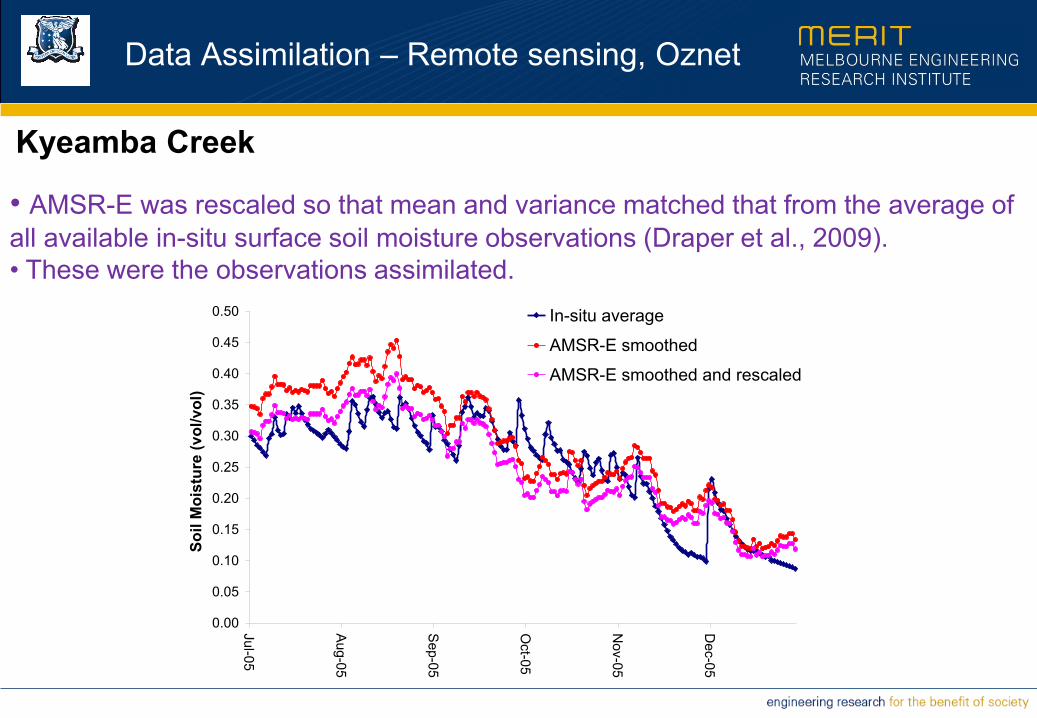
In-situ average
AMSR-E smoothed
AMSR-E smoothed and rescaled
Kyeamba Creek
• AMSR-E was rescaled so that mean and variance matched that from the average of
all available in-situ surface soil moisture observations (Draper et al., 2009).
• These were the observations assimilated.

Data Assimilation – Remote sensing, Oznet
Kyeamba Creek – Surface soil moisture results
Observ
ed
mod
elle
d
diffe
ren
ces
Near Surface Root Zone (0-60cm)
Observ
ed m
odelle
d
diffe
rence
s

Data Assimilation – Remote sensing, Oznet
Open Loop In-situ Assimilated
Observ
ed m
odelle
d
diffe
rence
s
Observ
ed m
odelle
d
diffe
rence
s
Near Surface Root Zone (0-60cm)
In-situ Open Loop Assimilated

Data Assimilation – Remote sensing, Oznet
K1
0.00
0.05
0.10
0.15
0.20
0.25
0.30
0.35
0.40
0.45
0.50
Ju
l-05
Aug-0
5
Sep-0
5
Oct-0
5
No
v-0
5
De
c-0
5
So
il M
ois
ture
(v
ol/v
ol)
K2
0.00
0.05
0.10
0.15
0.20
0.25
0.30
0.35
0.40
0.45
0.50
Ju
l-05
Aug-0
5
Sep-0
5
Oct-0
5
No
v-0
5
De
c-0
5
So
il M
ois
ture
(v
ol/v
ol)
K3
0.00
0.05
0.10
0.15
0.20
0.25
0.30
0.35
0.40
0.45
0.50
Ju
l-05
Aug-0
5
Sep-0
5
Oct-0
5
No
v-0
5
De
c-0
5
So
il M
ois
ture
(v
ol/
vo
l)
K4&5
0.00
0.05
0.10
0.15
0.20
0.25
0.30
0.35
0.40
0.45
0.50
Ju
l-05
Aug-0
5
Sep-0
5
Oct-0
5
No
v-0
5
De
c-0
5
So
il M
ois
ture
(v
ol/v
ol)
FS
0.00
0.05
0.10
0.15
0.20
0.25
0.30
0.35
0.40
0.45
0.50
Ju
l-05
Aug-0
5
Sep-0
5
Oct-0
5
No
v-0
5
De
c-0
5
So
il M
ois
ture
(v
ol/v
ol)
AMSR-E
In-situ
SM_spag
OpenLoop_sp
Kyeamba Creek station sites – near surface

Data Assimilation – Remote sensing, Oznet
In-situ
SM_spag
OpenLoop_sp
Kyeamba Creek station sites – Root zone (0-60cm)
K1
0.00
0.05
0.10
0.15
0.20
0.25
0.30
0.35
0.40
0.45
0.50
Ju
l-05
Au
g-0
5
Se
p-0
5
Oct-0
5
No
v-0
5
De
c-0
5
So
il M
ois
ture
(v
ol/v
ol)
K2
0.00
0.05
0.10
0.15
0.20
0.25
0.30
0.35
0.40
0.45
0.50
Ju
l-05
Au
g-0
5
Se
p-0
5
Oct-0
5
No
v-0
5
De
c-0
5
So
il M
ois
ture
(v
ol/
vo
l)
K3
0.00
0.05
0.10
0.15
0.20
0.25
0.30
0.35
0.40
0.45
0.50
Jul-0
5
Aug-0
5
Sep-0
5
Oct-0
5
Nov-0
5
Dec-0
5
So
il M
ois
ture
(vo
l/v
ol)
K4&5
0.00
0.05
0.10
0.15
0.20
0.25
0.30
0.35
0.40
0.45
0.50
Ju
l-05
Au
g-0
5
Se
p-0
5
Oct-0
5
No
v-0
5
De
c-0
5
So
il M
ois
ture
(v
ol/
vo
l)
K10&FS
0.00
0.05
0.10
0.15
0.20
0.25
0.30
0.35
0.40
0.45
0.50
Ju
l-05
Aug-0
5
Sep-0
5
Oct-0
5
No
v-0
5
De
c-0
5
So
il M
ois
ture
(v
ol/
vo
l)
Data Assimilation – Remote sensing, Oznet
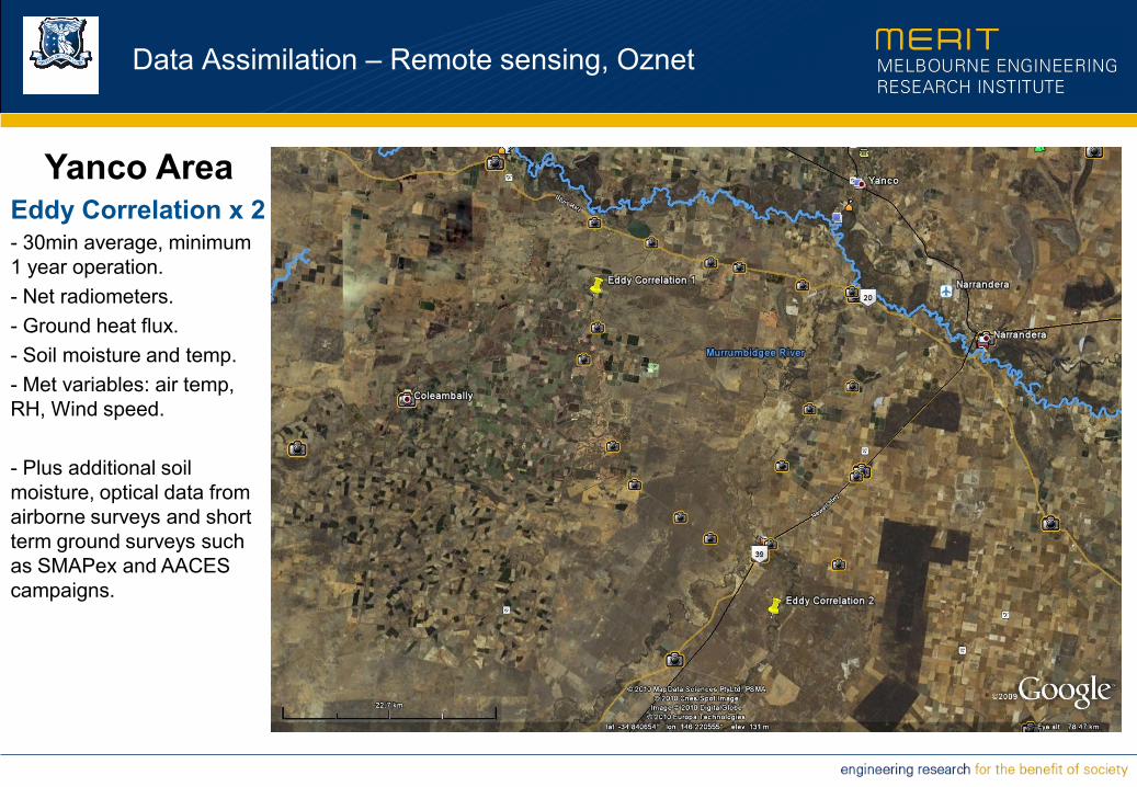
Yanco Area Eddy Correlation x 2 - 30min average, minimum
1 year operation.
- Net radiometers.
- Ground heat flux.
- Soil moisture and temp.
- Met variables: air temp,
RH, Wind speed.
- Plus additional soil
moisture, optical data from
airborne surveys and short
term ground surveys such
as SMAPex and AACES
campaigns.

Eddy Correlation1: Winter crop
Running since Early January 2010 - Winter cereal crop site.
- EC ~3m high.
- Gap from April to August (~4months)

Eddy Correlation2: Dryland pasture area
Running since late November 2009 - Non-irrigated grazing pasture land.
- EC ~3m high.

Data Assimilation – Remote sensing, Oznet
Modelling/Data Assimilation domain -
Yanco area
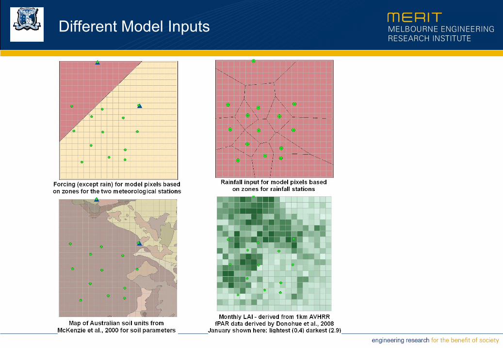
Different Model Inputs

Model Outputs of surface soil moisture
Op
en
Lo
op
A
ssim
ila
tio
n

Multi-sensor Data Assimilation
Summary
• A distributed network of in-situ measurements such as from Oznet
that can be carefully monitored and calibrated are crucial for validating
Remotely sensed products and model predictions...
• Continued efforts to better understand within pixel variation are
needed, given scale mismatch between in-situ and remotely sensed
data
• Attention needs to be paid to certain model structures to address
limitations to improving root zone soil moisture from surface moisture
assimilation such as is available from satellite information.