Embed Size (px)
Citation preview
MODELING AND VISUALIZATION USING LASER SCANNER IN DOCUMENTATION
OF CULTURAL HERITAGE
H.Karabork a, *, F.Yildiz a, M.Yakar a, C. Altuntas a, L.Karasaka a
a Selcuk University, Engineering Faculty, Geodesy and photogrammetry Engineering 42075 Selcuklu Konya, Turkey -
(hkarabork, fyildiz, yakar, caltuntas, lutfiye)@selcuk.edu.tr
KEY WORDS: Terrestrial laser scanning, modeling, visualization, cultural heritage
ABSTRACT:
Laser scanning technology has deeply modified the approach to surveying cultural heritage. The documentation of cultural heritage
with laser scanning is both easier and faster than other methods. The aim of this work is to produce digital surface models,
orthophoto, and visualization of a cultural heritage using point cloud. In this paper, the surveying of the sarcophagus obtained by
laser scanner technique. The Sarcophagus is typical of paphylia and belongs to Roman Period III. Century A.D. To obtain the model
of sarcophagus, several scanning have been made in all facade of sarcophagus. The integration of point cloud of all facades was
conducted by Polyworks commercial software. Modeling, orthophoto and visualization has been carried out by the software.
* Corresponding author.
1. INTRODUCTION
Laser scanning technology with its automated capture
capabilities is bringing new perspectives and can satisfy most
requirements of cultural heritage type of applications (Haddad
and Akasheh, 2005). One of the main features of the laser
scanning technique is to a collect a great data amount and to
give a detailed 3D model of the object (Fiani and Siani, 2005).
The demand for 3D models of historical objects is continuously
growing in the field of archaeological and architectural
applications. Currently, in addition to traditional manual
methods of survey, the two main sources of data that can
provide detailed and reliable 3D surface models are the
photogrammetric processing of digital images and laser
scanning point clouds (Ioannidis et al., 2005). The recording
and documentation of historic objects can be greatly enhanced
in terms of speed and accuracy of data collection using close
range photogrammetry and laser scanning. Laser scanning and
close range photogrammetry records an object and supplies
measurement data, texture, color and geometry defining object
(Murphy et al., 2005). Traditional heritage recording methods
like terrestrial photogrammetry are not suitable for all kinds of
objects. Particularly when the objects have very irregular
surfaces and not a clearly defined structure, scanning will
probably yield better results than photogrammetry. The main
difference between scanning and photogrammetry is obvious:
While photogrammetric surveying is an indirect data acquisition
method, scanning produces 3D points directly (Haddad and
Akasheh, 2005).
The main goal of this work is to study and experiment the use of
the laser scanning technique to survey a cultural heritage.
2. MATERIAL AND METHOD
2.1 The Sarcophagus
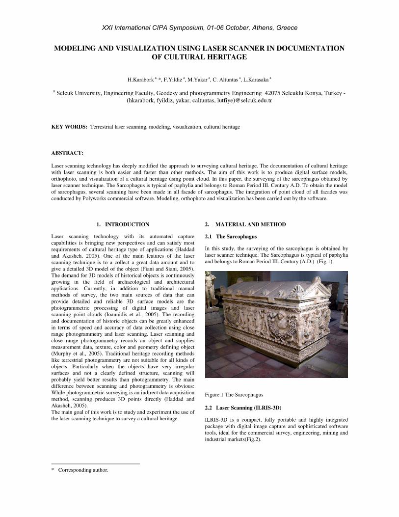
In this study, the surveying of the sarcophagus is obtained by
laser scanner technique. The Sarcophagus is typical of paphylia
and belongs to Roman Period III. Century (A.D.) (Fig.1).
Figure.1 The Sarcophagus
2.2 Laser Scanning (ILRIS-3D)
ILRIS-3D is a compact, fully portable and highly integrated
package with digital image capture and sophisticated software
tools, ideal for the commercial survey, engineering, mining and
industrial markets(Fig.2).
XXI International CIPA Symposium, 01-06 October, Athens, Greece
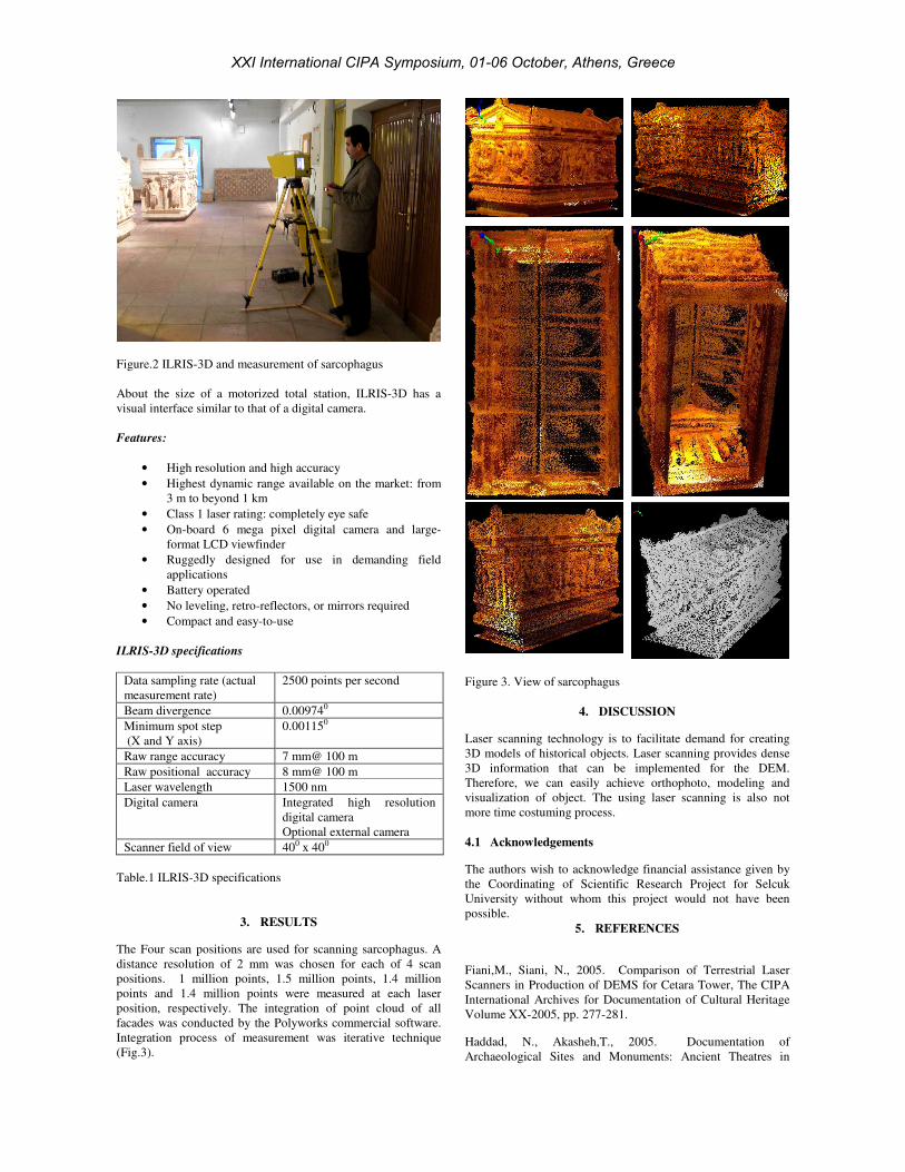
Figure.2 ILRIS-3D and measurement of sarcophagus
About the size of a motorized total station, ILRIS-3D has a
visual interface similar to that of a digital camera.
Features:
• High resolution and high accuracy
• Highest dynamic range available on the market: from
3 m to beyond 1 km
• Class 1 laser rating: completely eye safe
• On-board 6 mega pixel digital camera and large-
format LCD viewfinder
• Ruggedly designed for use in demanding field
applications
• Battery operated
• No leveling, retro-reflectors, or mirrors required
• Compact and easy-to-use
ILRIS-3D specifications
Data sampling rate (actual
measurement rate)
2500 points per second
Beam divergence 0.009740
Minimum spot step
(X and Y axis)
0.001150
Raw range accuracy 7 mm@ 100 m
Raw positional accuracy 8 mm@ 100 m
Laser wavelength 1500 nm
Digital camera Integrated high resolution
digital camera
Optional external camera
Scanner field of view 400 x 400
Table.1 ILRIS-3D specifications
3. RESULTS
The Four scan positions are used for scanning sarcophagus. A
distance resolution of 2 mm was chosen for each of 4 scan
positions. 1 million points, 1.5 million points, 1.4 million
points and 1.4 million points were measured at each laser
position, respectively. The integration of point cloud of all
facades was conducted by the Polyworks commercial software.
Integration process of measurement was iterative technique
(Fig.3).
Figure 3. View of sarcophagus
4. DISCUSSION
Laser scanning technology is to facilitate demand for creating
3D models of historical objects. Laser scanning provides dense
3D information that can be implemented for the DEM.
Therefore, we can easily achieve orthophoto, modeling and
visualization of object. The using laser scanning is also not
more time costuming process.
4.1 Acknowledgements
The authors wish to acknowledge financial assistance given by
the Coordinating of Scientific Research Project for Selcuk
University without whom this project would not have been
possible.
5. REFERENCES
Fiani,M., Siani, N., 2005. Comparison of Terrestrial Laser
Scanners in Production of DEMS for Cetara Tower, The CIPA
International Archives for Documentation of Cultural Heritage
Volume XX-2005, pp. 277-281.
Haddad, N., Akasheh,T., 2005. Documentation of
Archaeological Sites and Monuments: Ancient Theatres in
XXI International CIPA Symposium, 01-06 October, Athens, Greece

Jeash, The CIPA International Archives for Documentation of
Cultural Heritage Volume XX-2005, pp. 350-355.
Ioannidis, Ch., Demir, N., Soile, S., Tsakiri, M., 2005.
Combination of Laser Scanner Data and Simple
Photogrammetric Procedures for Surface Reconstruction of
Monuments, The CIPA International Archives for
Documentation of Cultural Heritage Volume XX-2005, pp.
372-377.
Murphy, M., McGovern, E., Olwill, R., Pavia, S., 2005.
Identification of Historic Methods of Construction Using
Digital Photogrammetry and Laser Scanning, The CIPA
International Archives for Documentation of Cultural Heritage
Volume XX-2005, pp. 466-469.
http://www.optech.ca/pdf/Brochures/ilris_36d.pdf (accessed 28
May. 2007)
XXI International CIPA Symposium, 01-06 October, Athens, Greece