Embed Size (px)
Citation preview
MODDIBO ADAMA UNIVERSITY OF TECHNOLOGY YOLA AND NATIONAL OFFICE FOR TECHNOLOGY ACQUISITION AND PROMOTION (NOTAP)
REASEARCH OPPORTUNITIES IN RIVER BASINS DEVELOPMENT AUTHORITIES
A CASE STUDY OF UPPER BENUE BASIN
PRESENTED BY ENGR. ABUBAKAR H. MU’AZU
DEPUTY DIRECTOR OPERATIONS UPPER BENUE RIVER BASIN
DEVELOPMENT AUTHORITY YOLAOCTOBER, 2011

INTRODUCTION
The Authority was established by decree no.25 of 1976, amended by decree no.87 of 1979, again amended by decree no. 35 of 1987.The operational area of the Authority is based on the geographical area of all the major tributaries of the Benue River upstream of Ibbi town in Taraba State, comprising Adamawa Central and South Senatorial districts, Bauchi South Senatorial district, all the three Senatorial districts of Gombe and Taraba States.
The functions of each Authority shall be-to undertake comprehensive development of both surface and underground water resources for multipurpose use with particular emphasis on the provision of irrigation infrastructure and the control of Flood and erosion and for water-shed management;to construct, operate and maintain dams, dykes, polders, wells, boreholes, irrigation and drainage systems, and other works necessary for the achievement of the authority’s functions and hand over all lands to be cultivated under the irrigation scheme to the farmers;to supply water from the Authority’s completed storage schemes to all users for a fee to be determined by the Authority concerned, With the approval of the Minister;to construct, operate and maintain infrastructural services such as roads and bridges linking project sites; provided that such infrastructural services are included and form an integral part of the list of approved projects;to develop and keep up-to-date comprehensive water resources master plan, indentifying all water resources requirements in the Authority’s area of operation, through adequate collection and collation of water resources, water use, socio-economic and environmental data of the River Basin.
2
FUNCTIONS

3
LOCATION MAP OF UPPER BENUE BASIN RIVER BASIN DEVELOPMENT AUTHORITY, YOLA CATCHMENT AREA (257,606Km2)
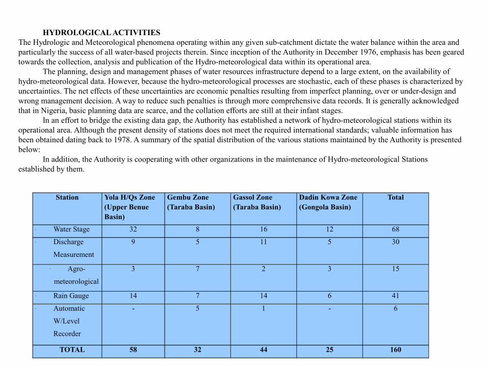
Station Yola H/Qs Zone(Upper Benue Basin)
Gembu Zone(Taraba Basin)
Gassol Zone(Taraba Basin)
Dadin Kowa Zone(Gongola Basin)
Total
- Water Stage 32 8 16 12 68- Discharge
Measurement
9 5 11 5 30
- Agro-
meteorological
3 7 2 3 15
- Rain Gauge 14 7 14 6 41- Automatic
W/Level
Recorder
- 5 1 - 6
TOTAL 58 32 44 25 160
HYDROLOGICAL ACTIVITIESThe Hydrologic and Meteorological phenomena operating within any given sub-catchment dictate the water balance within the area and particularly the success of all water-based projects therein. Since inception of the Authority in December 1976, emphasis has been geared towards the collection, analysis and publication of the Hydro-meteorological data within its operational area.
The planning, design and management phases of water resources infrastructure depend to a large extent, on the availability of hydro-meteorological data. However, because the hydro-meteorological processes are stochastic, each of these phases is characterized by uncertainties. The net effects of these uncertainties are economic penalties resulting from imperfect planning, over or under-design and wrong management decision. A way to reduce such penalties is through more comprehensive data records. It is generally acknowledged that in Nigeria, basic planning data are scarce, and the collation efforts are still at their infant stages.
In an effort to bridge the existing data gap, the Authority has established a network of hydro-meteorological stations within its operational area. Although the present density of stations does not meet the required international standards; valuable information has been obtained dating back to 1978. A summary of the spatial distribution of the various stations maintained by the Authority is presented below:
In addition, the Authority is cooperating with other organizations in the maintenance of Hydro-meteorological Stations established by them.
3
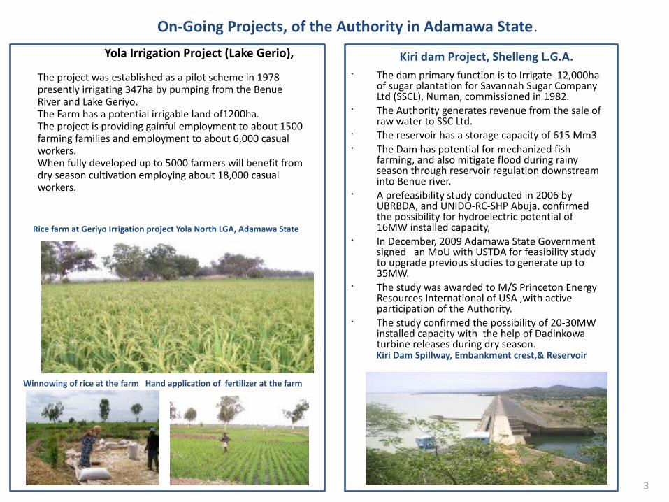
Yola Irrigation Project (Lake Gerio),
The project was established as a pilot scheme in 1978 presently irrigating 347ha by pumping from the Benue River and Lake Geriyo.The Farm has a potential irrigable land of1200ha.The project is providing gainful employment to about 1500 farming families and employment to about 6,000 casual workers.When fully developed up to 5000 farmers will benefit from dry season cultivation employing about 18,000 casual workers.
• The dam primary function is to Irrigate 12,000ha of sugar plantation for Savannah Sugar Company Ltd (SSCL), Numan, commissioned in 1982.
• The Authority generates revenue from the sale of raw water to SSC Ltd.
• The reservoir has a storage capacity of 615 Mm3 • The Dam has potential for mechanized fish
farming, and also mitigate flood during rainy season through reservoir regulation downstream into Benue river.
• A prefeasibility study conducted in 2006 by UBRBDA, and UNIDO-RC-SHP Abuja, confirmed the possibility for hydroelectric potential of 16MW installed capacity,
• In December, 2009 Adamawa State Government signed an MoU with USTDA for feasibility study to upgrade previous studies to generate up to 35MW.
• The study was awarded to M/S Princeton Energy Resources International of USA ,with active participation of the Authority.
• The study confirmed the possibility of 20-30MW installed capacity with the help of Dadinkowa turbine releases during dry season.
Kiri dam Project, Shelleng L.G.A.
Rice farm at Geriyo Irrigation project Yola North LGA, Adamawa State
Winnowing of rice at the farm Hand application of fertilizer at the farm
Kiri Dam Spillway, Embankment crest,& Reservoir
On-Going Projects, of the Authority in Adamawa State.
6
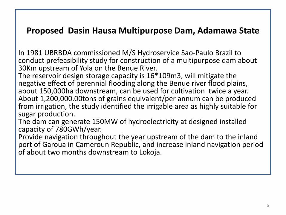
In 1981 UBRBDA commissioned M/S Hydroservice Sao-Paulo Brazil to conduct prefeasibility study for construction of a multipurpose dam about 30Km upstream of Yola on the Benue River.The reservoir design storage capacity is 16*109m3, will mitigate the negative effect of perennial flooding along the Benue river flood plains, about 150,000ha downstream, can be used for cultivation twice a year.About 1,200,000.00tons of grains equivalent/per annum can be produced from irrigation, the study identified the irrigable area as highly suitable for sugar production. The dam can generate 150MW of hydroelectricity at designed installed capacity of 780GWh/year.Provide navigation throughout the year upstream of the dam to the inland port of Garoua in Cameroun Republic, and increase inland navigation period of about two months downstream to Lokoja.
Proposed Dasin Hausa Multipurpose Dam, Adamawa State
7
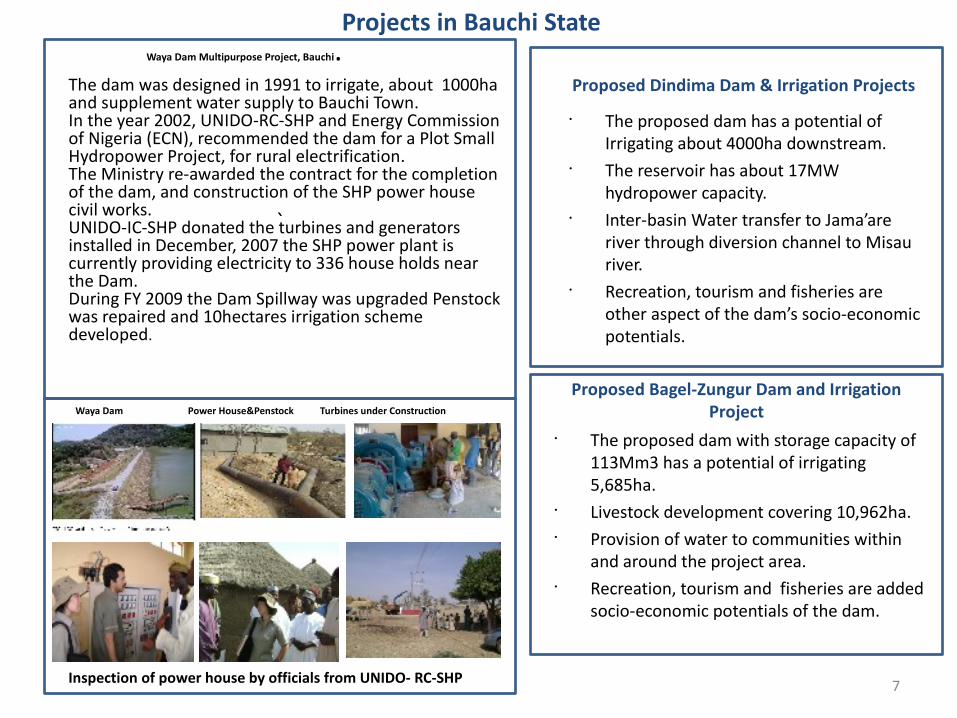
Waya Dam Multipurpose Project, Bauchi.The dam was designed in 1991 to irrigate, about 1000ha and supplement water supply to Bauchi Town.In the year 2002, UNIDO-RC-SHP and Energy Commission of Nigeria (ECN), recommended the dam for a Plot Small Hydropower Project, for rural electrification.The Ministry re-awarded the contract for the completion of the dam, and construction of the SHP power house civil works.UNIDO-IC-SHP donated the turbines and generators installed in December, 2007 the SHP power plant is currently providing electricity to 336 house holds near the Dam.During FY 2009 the Dam Spillway was upgraded Penstock was repaired and 10hectares irrigation scheme developed.
• The proposed dam has a potential of Irrigating about 4000ha downstream.
• The reservoir has about 17MW hydropower capacity.
• Inter-basin Water transfer to Jama’are river through diversion channel to Misau river.
• Recreation, tourism and fisheries are other aspect of the dam’s socio-economic potentials.
Proposed Dindima Dam & Irrigation Projects
Proposed Bagel-Zungur Dam and Irrigation Project
Projects in Bauchi State
`
• The proposed dam with storage capacity of 113Mm3 has a potential of irrigating 5,685ha.
• Livestock development covering 10,962ha.• Provision of water to communities within
and around the project area.• Recreation, tourism and fisheries are added
socio-economic potentials of the dam.
Inspection of power house by officials from UNIDO- RC-SHP
Waya Dam Power House&Penstock Turbines under Construction

8
Dadinkowa Multipurpose Dam, Yamaltu/Deba L.G.A, Gombe State.
The Construction of the dam started in 1981 and completed in 1987.The Dam has a reservoir capacity of 2.8*109m3, live storage 1.77*109m3, made of earth rock-fill embankment, crest length about 520m, maximum height 47m, Ogee Crested Spillway equipped with radial gates and Power house.The H.E.P has a design installed capacity of 34MW, electricity generation output 224.74GWh/annum that can generate revenue about N2.25 billion gross, at N10.00/kwh The Dam has a potential to irrigate about 25,000ha net downstream which can produce about 200,000tons of grains equivalent twice a year that can generate about N6billion gross.Through mechanized fish farming, about 20,000tons of fish can be harvested annually from the reservoir that can generate about N10b at N500.00 per kg.Presently only 100ha is under irrigation, by abstraction of water from the river, due to non completion of the irrigation scheme.Under the FY 2009 the contract for the continuation of work on main canal (1.3km) is in appreciable progress.
Dam, Embankment, Spillway radial gates,& Power House
Turbines components under fabrication by Voest Alpine Austria, 1982
9
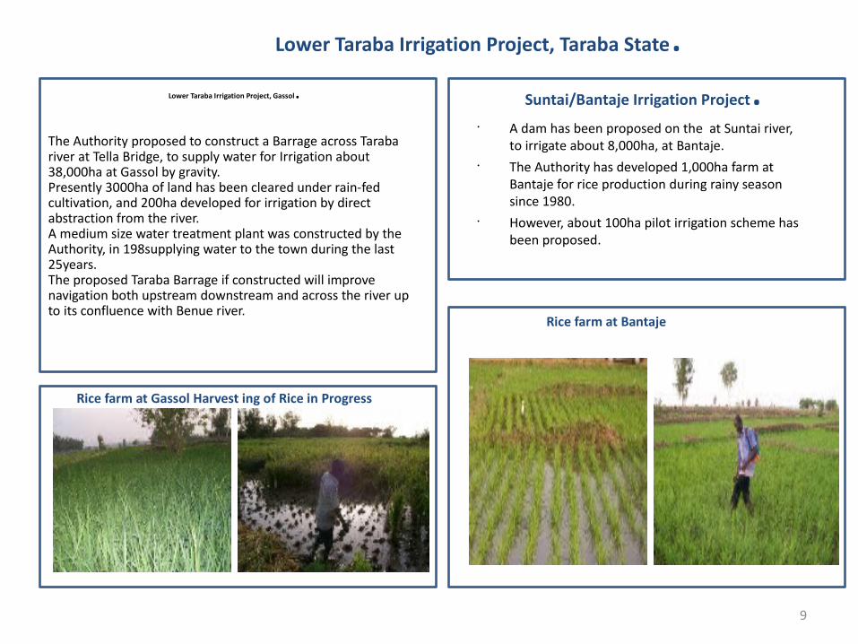
Lower Taraba Irrigation Project, Gassol.
The Authority proposed to construct a Barrage across Taraba river at Tella Bridge, to supply water for Irrigation about 38,000ha at Gassol by gravity.Presently 3000ha of land has been cleared under rain-fed cultivation, and 200ha developed for irrigation by direct abstraction from the river.A medium size water treatment plant was constructed by the Authority, in 198supplying water to the town during the last 25years.The proposed Taraba Barrage if constructed will improve navigation both upstream downstream and across the river up to its confluence with Benue river.
• A dam has been proposed on the at Suntai river, to irrigate about 8,000ha, at Bantaje.
• The Authority has developed 1,000ha farm at Bantaje for rice production during rainy season since 1980.
• However, about 100ha pilot irrigation scheme has been proposed.
Suntai/Bantaje Irrigation Project.
Rice farm at Gassol Harvest ing of Rice in Progress
Rice farm at Bantaje
Lower Taraba Irrigation Project, Taraba State.
10
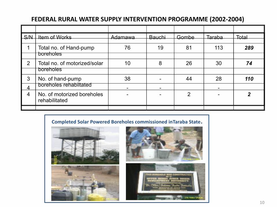
FEDERAL RURAL WATER SUPPLY INTERVENTION PROGRAMME (2002-2004)
S/N Item of Works Adamawa Bauchi Gombe Taraba Total
1 Total no. of Hand-pump boreholes
76 19 81 113 289
2 Total no. of motorized/solar boreholes
10 8 26 30 74
3 No. of hand-pump boreholes rehabiltated
38 - 44 28 110
4 No. of motorized boreholes rehabilitated
- - 2 - 24 - - -
Completed Solar Powered Boreholes commissioned inTaraba State.
11
S/N
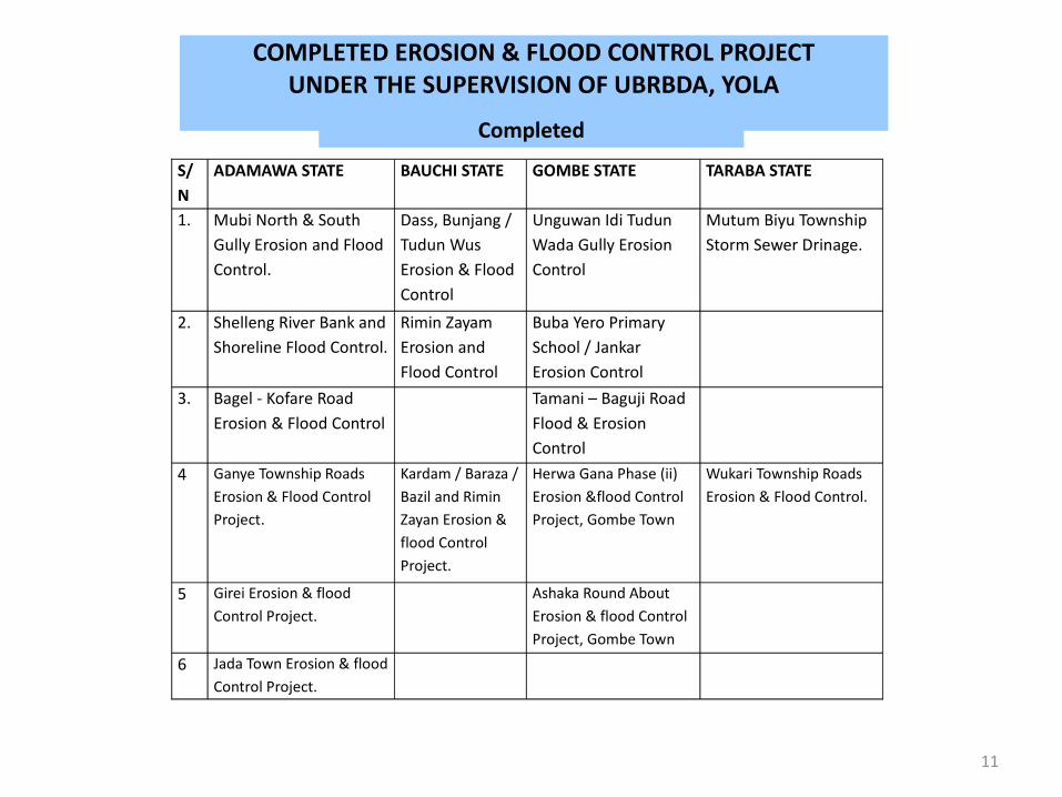
ADAMAWA STATE BAUCHI STATE GOMBE STATE TARABA STATE
1. Mubi North & South Gully Erosion and Flood Control.
Dass, Bunjang / Tudun Wus Erosion & Flood Control
Unguwan Idi Tudun Wada Gully Erosion Control
Mutum Biyu Township Storm Sewer Drinage.
2. Shelleng River Bank and Shoreline Flood Control.
Rimin Zayam Erosion and Flood Control
Buba Yero Primary School / Jankar Erosion Control
3. Bagel - Kofare Road Erosion & Flood Control
Tamani – Baguji Road Flood & Erosion Control
4 Ganye Township Roads Erosion & Flood Control Project.
Kardam / Baraza / Bazil and Rimin Zayan Erosion & flood Control Project.
Herwa Gana Phase (ii) Erosion &flood Control Project, Gombe Town
Wukari Township Roads Erosion & Flood Control.
5 Girei Erosion & flood Control Project.
Ashaka Round About Erosion & flood Control Project, Gombe Town
6 Jada Town Erosion & flood Control Project.
COMPLETED EROSION & FLOOD CONTROL PROJECTUNDER THE SUPERVISION OF UBRBDA, YOLA
Completed
12
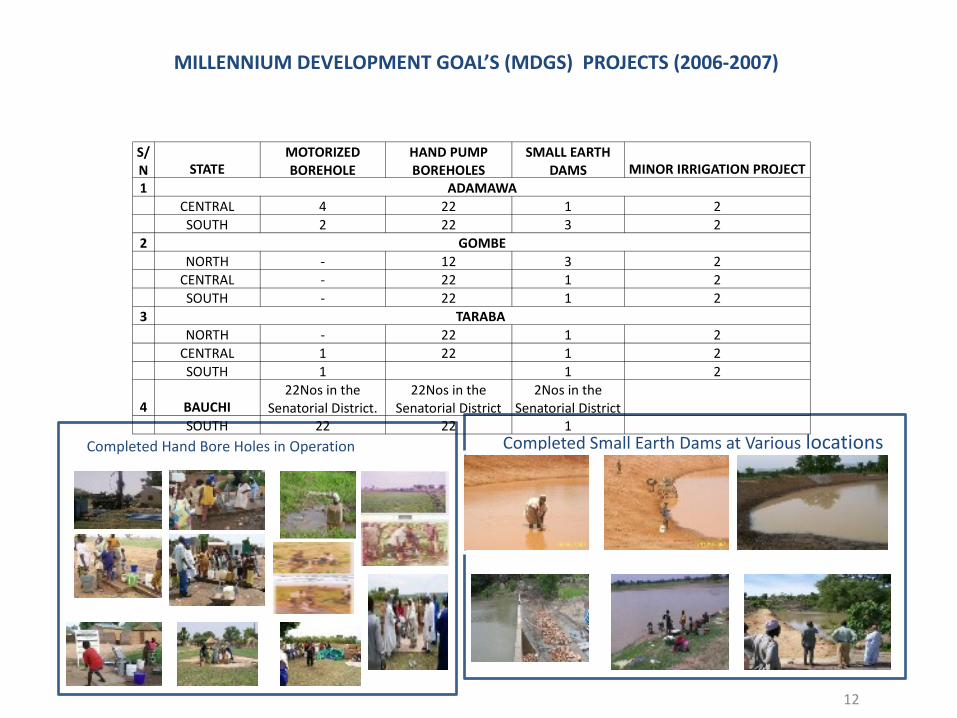
Completed Hand Bore Holes in Operation
MILLENNIUM DEVELOPMENT GOAL’S (MDGS) PROJECTS (2006-2007)
Completed Small Earth Dams at Various locations
S/N STATE
MOTORIZED BOREHOLE
HAND PUMP BOREHOLES
SMALL EARTH DAMS MINOR IRRIGATION PROJECT
1 ADAMAWA CENTRAL 4 22 1 2 SOUTH 2 22 3 22 GOMBE NORTH - 12 3 2 CENTRAL - 22 1 2 SOUTH - 22 1 23 TARABA NORTH - 22 1 2 CENTRAL 1 22 1 2 SOUTH 1 1 2
4 BAUCHI22Nos in the
Senatorial District.22Nos in the
Senatorial District2Nos in the
Senatorial District SOUTH 22 22 1
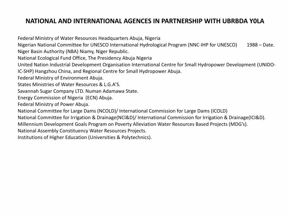
NATIONAL AND INTERNATIONAL AGENCES IN PARTNERSHIP WITH UBRBDA Y0LA
Federal Ministry of Water Resources Headquarters Abuja, NigeriaNigerian National Committee for UNESCO International Hydrological Program (NNC-IHP for UNESCO) 1988 – Date.Niger Basin Authority (NBA) Niamy, Niger Republic.National Ecological Fund Office, The Presidency Abuja NigeriaUnited Nation Industrial Development Organisation International Centre for Small Hydropower Development (UNIDO-IC-SHP) Hangzhou China, and Regional Centre for Small Hydropower Abuja.Federal Ministry of Environment Abuja.States Ministries of Water Resources & L.G.A’S.Savannah Sugar Company LTD. Numan Adamawa State.Energy Commission of Nigeria (ECN) Abuja.Federal Ministry of Power Abuja.National Committee for Large Dams (NCOLD)/ International Commission for Large Dams (ICOLD) National Committee for Irrigation & Drainage(NCI&D)/ International Commission for Irrigation & Drainage(ICI&D).Millennium Development Goals Program on Poverty Alleviation Water Resources Based Projects (MDG’s).National Assembly Constituency Water Resources Projects.Institutions of Higher Education (Universities & Polytechnics).