Embed Size (px)
Citation preview
Mobile Robots for the Simultaneous Exploration and 2DDetermination of Radioactivity
MICHAEL MARSZALEK, MARTIN EDERANDREAS TROPSCHUG and ALOIS KNOLL
Technische Universitat MunchenDepartment of Informatics -
Robotics and Embedded SystemsBoltzmannstr. 3, Garching bei Munchen
GERMANY{marszale, martin.eder, tropschu, knoll}@in.tum.de
HAGEN HOFERHOFER & BECHTEL GmbHOstring 1, 63533 Mainhausen
Abstract: In the past years, various robotic inspection systems have been developed for industrial automation.The industry offers a wide range of applications for robotic systems. The inspection and cleaning of severs oran automation of a biotechnology laboratory are successful examples for robotic systems and automation [1]. Inthis paper, we present a novel system for the autonomous 2D determination of radioactivity and contaminatedareas. The importance of autonomous determination of radioactivity, in the course of disassembly of nuclearpower plants, will rise in the upcoming years. It enables remarkable possible savings, concerning work time andpersonnel expenses. Our mobile robot is able to scan incrementally the whole floor of a building, in order to assureclean environments in nuclear power plants or castors, and marks the contaminated areas in a generated map of thebuilding for further evaluation. The paper discusses the main requirements of a navigation system for 2D detectionof radioactivity, presents the hardware and software set-up and some real-world experiments with our mobile robot.
Key–Words: Industrial Application, Automation in Medicine, Automation, Robotics, SLAM, Path planning
1 IntroductionGenerally, the challenging field of robotics has anenormous potential to support the industry in differ-ent fields. A robot is able to perceive and manipulatethe physical world by means of different devices andcan act in various working environments, for exam-ple planetary explorations, in the car industry or as ademonstrator in a theatre.The market for service robots has an excellent chancefor the future. An example for successful commercialsystems are cleaning robots which have been stud-ied and developed some years ago. Meanwhile, themarket offers some cleaning robots for private pur-pose. The common enabling technology for a clean-ing robot and our application is autonomous naviga-tion in everyday indoor environments. In contrast, themain difference is the efficiency of our navigation sys-tem. While a hoover robot usually cleans the floorrandomly, our system aims to document all radioac-tivity measurements for every reachable position inthe environment. The handling with radioactivity in anuclear power plant or radiology demanded some re-quirements, concerning the compliance of safety mea-sures. One important safety task is the securing ofa contamination-free working environment, typically
needed in a nuclear power plant. Usually, the mea-surements are done by hand and thus a member ofstaff has to invest a lot of time for the safekeeping ofa contamination-free building. It is necessary to pre-pare a documentation of every checked plane of thefloor or walls. In the case of contamination, the ex-act position of the determined area has to be markedin a map of the building. The application of robotscould be extremely timesaving, unforgeable and re-duces physically demanding occupations. Our ap-
Figure 1: Mobile Robot
proach was driven by the idea for automation of thesafekeeping of a contamination-free environment. Weequipped a mobile robot with various devices whichfocuses on the detection of α, β and γ radiation incastors and nuclear power plants. The complexity of
RECENT ADVANCES in CIRCUITS, SYSTEMS, ELECTRONICS, CONTROL and SIGNAL PROCESSING
ISSN: 1790-5117 267 ISBN: 978-960-474-139-7
our system is manageable because we focused on thefloor of the areas. Thus, we did not need a roboticarm in order to reach walls and ceilings. The ap-plied mobile robot, called Robotino (see Figure 1), isequipped with an omnidirectional drive, three wheelsand multiple sensors. It is able to move in all direc-tions, as well as to turn on the spot through its recentdrive system. The control of the actuating elementsand acquisition of sensor data results from the WLANmodule. Alternatively, it is possible to use a networkcable for the communication with Robotino. FestoDidactic offers a software named ”Robotino View”,which is an interactive graphic programming tool forRobotino. Furthermore, an open-source framework,called OpenRobotino1, and the corresponding docu-mentation are available for the development of appli-cations. Robotino was additionally equipped with alaser rangefinder (SICK S300), two radioactivity de-tectors (CoMo 170) and an Intel Core Duo notebookfor the developed navigation framework.
Figure 2: CoMo 170
The contamination monitor (see Figure 2) servesfor the detection of radioactive contaminated surfaces.The hardware was built into a new box, which ismounted in front of Robotino. This box contains twodetectors to attain a complete cover. The standard PCof Robotino is not capable of fulfilling the computa-tion power requirement, why we run the navigationframework on a mounted notebook. A full, in-depthpresentation of all features of our system is beyond thescope of this paper. Rather, we will focus on the corefunctions of the software respectively mobile robot.In section 2, we will briefly describe some recentlydeveloped robotic and navigation systems, followedby the overall architecture of the system in section3. To validate our approach we perform multiple ex-periments in section 4 to confirm the accuracy of oursystem. For this purpose, we received a permissionfor an experiment in a laboratory of the Max-Planckinstitute in Mainz. The Alpha Particle X-Ray Spec-trometer (APXS), which determines the consistencyof stones and dust on the mars surface, was originallydeveloped in this laboratory.
1http://www.openrobotino.org
2 State of the ArtIn the past, several efforts have been made, regard-ing the creation of autonomous mobile robot systems.Since every creation had its specific requirements andinvolves the combination of several algorithms, wewill try to give a review for our work below. A mobilerobot for the automation of the complete sample man-agement in a biotechnology laboratory is presented in[2]. The navigation of this mobile robot is based ona generated static map of the current working envi-ronment. An other example, presented in [3], is theservice robot LISA (Life Science Assistant) whichsupports lab personnel in biological and pharmaceu-tical laboratories. It makes automated experiment cy-cles flexible and helps employees to prepare experi-ments, e.g. by collaboratively executing transporta-tion tasks or filling microplates. A Hokuyo URG-04LX is used for the localization in an a-priori mapand the collision detection. The map of the labora-tory is handmade and is initially used for the local-ization. A generation of a static map of the buildingsis time-consuming and presumes a new map for ev-ery domain. Our application needs a flexible adoptionof the robot, which requires the ability to map andexplore unknown environments right from the start.The main technology for this purpose is called Si-multaneous Localization and Mapping (SLAM) andhas been in the focus of many researchers for sev-eral years. SLAM deals with the problem of con-structing an accurate map of an environment in real-time. Thereby, it has to handle imperfect informa-tion about the robot’s trajectory through the environ-ment. For example, a robot which was placed in anunknown environment, incrementally builds a consis-tent map of its surroundings, while simultaneously de-termining its location within this map. OpenSlam 2
offers some open-source SLAM implementations likeGMapping or DP-SLAM. A Rao-Blackwellized parti-cle filter based approach (GMapping) is presented in[4][5]. It is able to produce accurate maps of indoorand outdoor environments using occupancy grids. Theopen-source library requires some programming ef-fort for the adoption and only runs under Linux sys-tems. Another framework, called CARMEN [6], pro-vides basic navigation primitives like path planning,mapping and localization. We used some generatedlog files for the evaluation of the mapping module. Itworks for small environments correctly, but it was notable to resolve the loop closing issue in large build-ings. The commercial framework KARTO 3 is a veryefficient solution for navigation tasks. It provides ex-ploration strategies, mapping and trajectory planning.
2http://www.openslam.org3http://www.kartorobotics.com
RECENT ADVANCES in CIRCUITS, SYSTEMS, ELECTRONICS, CONTROL and SIGNAL PROCESSING
ISSN: 1790-5117 268 ISBN: 978-960-474-139-7
A free functional trial copy is available for download.The evaluation of the mapping, using our carmen logfiles, has been very promising.[7][8] DP-SLAM needs odometry measurements andan accurate laser rangefinder, e.g. SICK S300, forlocalization and building a map. It uses a particlefilter to maintain a joint probability distribution overmaps and robot positions, as well as some efficientdata structures, which allow an efficient mapping.DP-SLAM does not need predetermined landmarksand is accurate enough to close loops without any spe-cial off-line techniques. The data association problemwas also eliminated through the abandonment of land-marks. Moreover, it is not necessary to predeterminethe environment.
In almost no exception, none of the open-sourcedistributions can be used without additional program-ming effort. The Karto framework is an ideal solu-tion for mobile robots, but we prefer an open-sourcesoftware, due to the costs for the licence. GMappingis an efficient and accurate SLAM algorithm but itneeds some additional adaptation for our application.In contrast, DP-SLAM was implemented and success-fully tested during a past project of our faculty. It runsunder Windows and Linux and can be easily config-ured for our mobile robot.
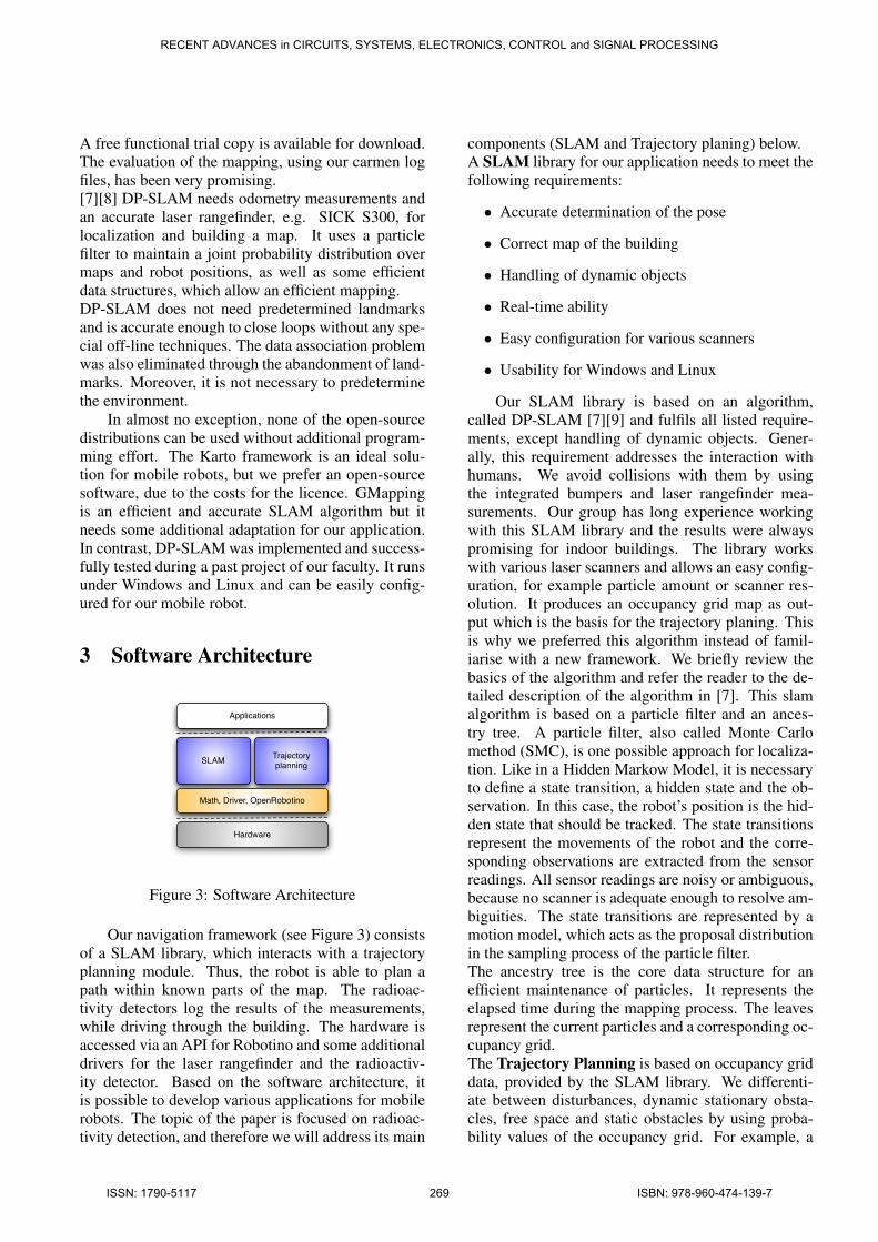
3 Software Architecture
Hardware
Math, Driver, OpenRobotino
SLAM Trajectory planning
Applications
Figure 3: Software Architecture
Our navigation framework (see Figure 3) consistsof a SLAM library, which interacts with a trajectoryplanning module. Thus, the robot is able to plan apath within known parts of the map. The radioac-tivity detectors log the results of the measurements,while driving through the building. The hardware isaccessed via an API for Robotino and some additionaldrivers for the laser rangefinder and the radioactiv-ity detector. Based on the software architecture, itis possible to develop various applications for mobilerobots. The topic of the paper is focused on radioac-tivity detection, and therefore we will address its main
components (SLAM and Trajectory planing) below.A SLAM library for our application needs to meet thefollowing requirements:
• Accurate determination of the pose
• Correct map of the building
• Handling of dynamic objects
• Real-time ability
• Easy configuration for various scanners
• Usability for Windows and Linux
Our SLAM library is based on an algorithm,called DP-SLAM [7][9] and fulfils all listed require-ments, except handling of dynamic objects. Gener-ally, this requirement addresses the interaction withhumans. We avoid collisions with them by usingthe integrated bumpers and laser rangefinder mea-surements. Our group has long experience workingwith this SLAM library and the results were alwayspromising for indoor buildings. The library workswith various laser scanners and allows an easy config-uration, for example particle amount or scanner res-olution. It produces an occupancy grid map as out-put which is the basis for the trajectory planing. Thisis why we preferred this algorithm instead of famil-iarise with a new framework. We briefly review thebasics of the algorithm and refer the reader to the de-tailed description of the algorithm in [7]. This slamalgorithm is based on a particle filter and an ances-try tree. A particle filter, also called Monte Carlomethod (SMC), is one possible approach for localiza-tion. Like in a Hidden Markow Model, it is necessaryto define a state transition, a hidden state and the ob-servation. In this case, the robot’s position is the hid-den state that should be tracked. The state transitionsrepresent the movements of the robot and the corre-sponding observations are extracted from the sensorreadings. All sensor readings are noisy or ambiguous,because no scanner is adequate enough to resolve am-biguities. The state transitions are represented by amotion model, which acts as the proposal distributionin the sampling process of the particle filter.The ancestry tree is the core data structure for anefficient maintenance of particles. It represents theelapsed time during the mapping process. The leavesrepresent the current particles and a corresponding oc-cupancy grid.The Trajectory Planning is based on occupancy griddata, provided by the SLAM library. We differenti-ate between disturbances, dynamic stationary obsta-cles, free space and static obstacles by using proba-bility values of the occupancy grid. For example, a
RECENT ADVANCES in CIRCUITS, SYSTEMS, ELECTRONICS, CONTROL and SIGNAL PROCESSING
ISSN: 1790-5117 269 ISBN: 978-960-474-139-7
high probability in a cell stands for a static obstacle.The trajectory planning is continuously updated withthe current pose of the robot and the occupancy grid,which represents the environment. These informationare used by the algorithm in order to place waypointsin free space. Each waypoint describes a possible po-sition of the robot. The distance between the way-points and the distance to walls can be set optional,but it has to be chosen carefully to avoid collisionswith static objects. A bounding box (geometry of therobot) is placed on every possible position next to therobot and a validation outputs the usability of this po-sition. If the box is located inside the explored areaand no obstacle overlaps the box, the algorithm ac-cepts that position as a possible waypoint. A roadrepresents the way between two waypoints, and it alsoenables a collisions-free driving.Road mapping is implemented by a graph data struc-ture. It reduces the problem of negotiating a paththrough a complex shaped 2D representation of theworld to finding a shortest path through a connectedgraph from node A to node B, for example.The trajectory planning computes a path through theknown part of the environment, starting from therobot’s current position. The robot drives to everygenerated waypoint, as long as a waypoint exists inthe map. The map of the environment is regularlyupdated with changes in the surrounding and regis-trations of unseen parts of the building. The trajec-tory module reacts accordingly to these changes andextends the path by new waypoints in these uncov-ered areas. Thus, we abandon an Exploration phasewhich would prolong the whole radioactivity searchprocess. The only one constraint for this approach isthe securing of a closed area. This is necessary to stopthe trajectory planning from exploring new parts ofthe building.The Documentation of the radioactivity measure-ments is done by logging all measurements for ev-ery reachable position in the map. For this purpose,the geometry of the box with its detectors, as well asthe deviation from the centre of the robot has to bedefined. Additionally, all results are marked in thecorresponding map. For example, the detection of ra-dioactivity is marked as a radioactivity sign and cleanareas are repainted in the map in green. The positionof detected radiation has a deviation of +/- 3 cm, dueto uncertainties in the localization process.
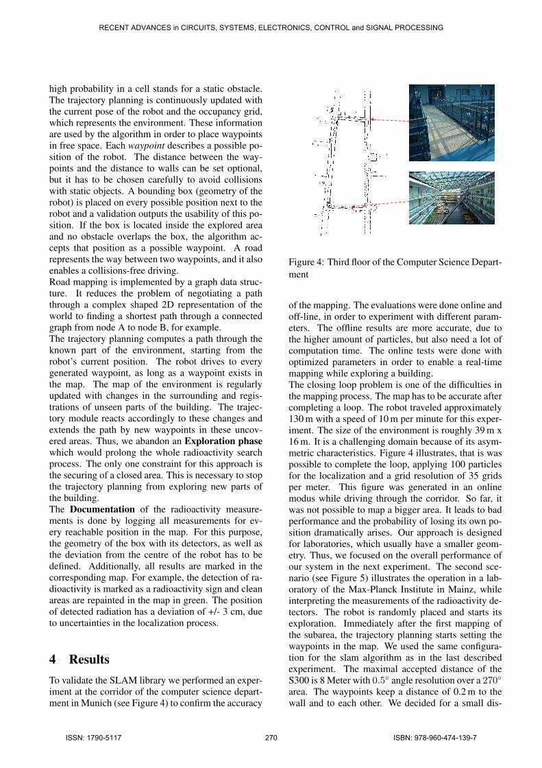
4 ResultsTo validate the SLAM library we performed an exper-iment at the corridor of the computer science depart-ment in Munich (see Figure 4) to confirm the accuracy
Figure 4: Third floor of the Computer Science Depart-ment
of the mapping. The evaluations were done online andoff-line, in order to experiment with different param-eters. The offline results are more accurate, due tothe higher amount of particles, but also need a lot ofcomputation time. The online tests were done withoptimized parameters in order to enable a real-timemapping while exploring a building.The closing loop problem is one of the difficulties inthe mapping process. The map has to be accurate aftercompleting a loop. The robot traveled approximately130 m with a speed of 10 m per minute for this exper-iment. The size of the environment is roughly 39 m x16 m. It is a challenging domain because of its asym-metric characteristics. Figure 4 illustrates, that is waspossible to complete the loop, applying 100 particlesfor the localization and a grid resolution of 35 gridsper meter. This figure was generated in an onlinemodus while driving through the corridor. So far, itwas not possible to map a bigger area. It leads to badperformance and the probability of losing its own po-sition dramatically arises. Our approach is designedfor laboratories, which usually have a smaller geom-etry. Thus, we focused on the overall performance ofour system in the next experiment. The second sce-nario (see Figure 5) illustrates the operation in a lab-oratory of the Max-Planck Institute in Mainz, whileinterpreting the measurements of the radioactivity de-tectors. The robot is randomly placed and starts itsexploration. Immediately after the first mapping ofthe subarea, the trajectory planning starts setting thewaypoints in the map. We used the same configura-tion for the slam algorithm as in the last describedexperiment. The maximal accepted distance of theS300 is 8 Meter with 0.5◦ angle resolution over a 270◦area. The waypoints keep a distance of 0.2 m to thewall and to each other. We decided for a small dis-
RECENT ADVANCES in CIRCUITS, SYSTEMS, ELECTRONICS, CONTROL and SIGNAL PROCESSING
ISSN: 1790-5117 270 ISBN: 978-960-474-139-7
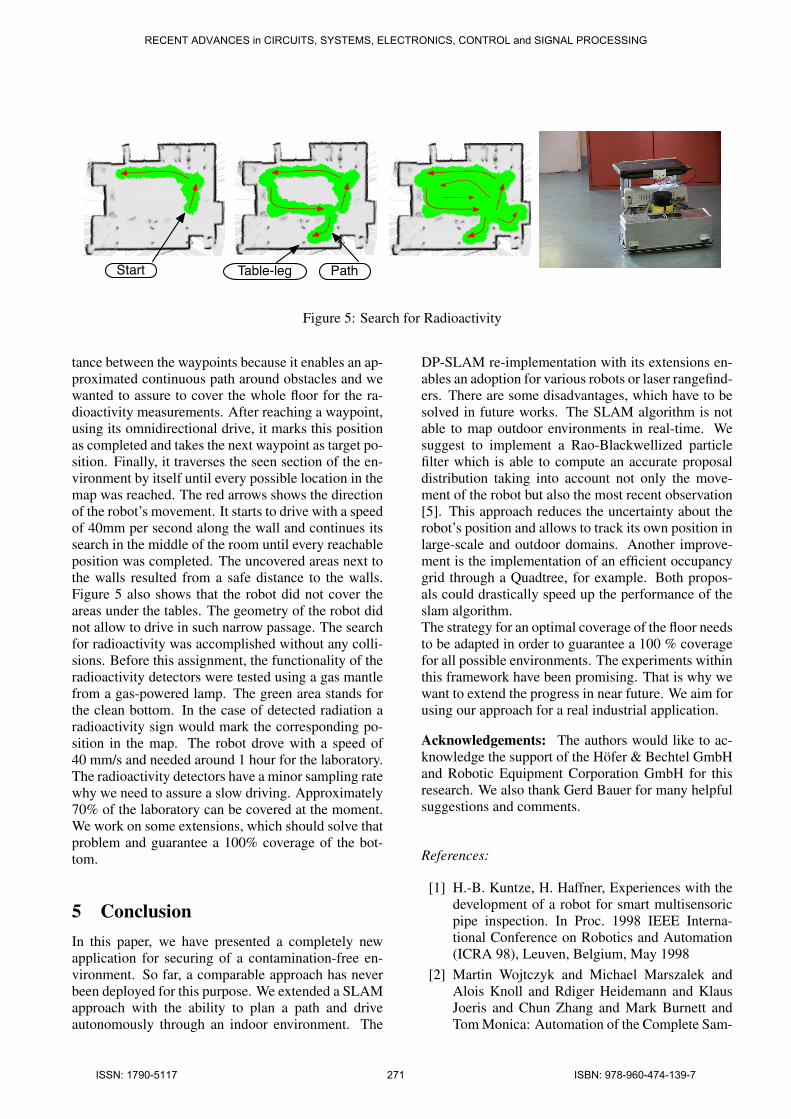
Start Table-leg Path
Figure 5: Search for Radioactivity
tance between the waypoints because it enables an ap-proximated continuous path around obstacles and wewanted to assure to cover the whole floor for the ra-dioactivity measurements. After reaching a waypoint,using its omnidirectional drive, it marks this positionas completed and takes the next waypoint as target po-sition. Finally, it traverses the seen section of the en-vironment by itself until every possible location in themap was reached. The red arrows shows the directionof the robot’s movement. It starts to drive with a speedof 40mm per second along the wall and continues itssearch in the middle of the room until every reachableposition was completed. The uncovered areas next tothe walls resulted from a safe distance to the walls.Figure 5 also shows that the robot did not cover theareas under the tables. The geometry of the robot didnot allow to drive in such narrow passage. The searchfor radioactivity was accomplished without any colli-sions. Before this assignment, the functionality of theradioactivity detectors were tested using a gas mantlefrom a gas-powered lamp. The green area stands forthe clean bottom. In the case of detected radiation aradioactivity sign would mark the corresponding po-sition in the map. The robot drove with a speed of40 mm/s and needed around 1 hour for the laboratory.The radioactivity detectors have a minor sampling ratewhy we need to assure a slow driving. Approximately70% of the laboratory can be covered at the moment.We work on some extensions, which should solve thatproblem and guarantee a 100% coverage of the bot-tom.
5 ConclusionIn this paper, we have presented a completely newapplication for securing of a contamination-free en-vironment. So far, a comparable approach has neverbeen deployed for this purpose. We extended a SLAMapproach with the ability to plan a path and driveautonomously through an indoor environment. The
DP-SLAM re-implementation with its extensions en-ables an adoption for various robots or laser rangefind-ers. There are some disadvantages, which have to besolved in future works. The SLAM algorithm is notable to map outdoor environments in real-time. Wesuggest to implement a Rao-Blackwellized particlefilter which is able to compute an accurate proposaldistribution taking into account not only the move-ment of the robot but also the most recent observation[5]. This approach reduces the uncertainty about therobot’s position and allows to track its own position inlarge-scale and outdoor domains. Another improve-ment is the implementation of an efficient occupancygrid through a Quadtree, for example. Both propos-als could drastically speed up the performance of theslam algorithm.The strategy for an optimal coverage of the floor needsto be adapted in order to guarantee a 100 % coveragefor all possible environments. The experiments withinthis framework have been promising. That is why wewant to extend the progress in near future. We aim forusing our approach for a real industrial application.
Acknowledgements: The authors would like to ac-knowledge the support of the Hofer & Bechtel GmbHand Robotic Equipment Corporation GmbH for thisresearch. We also thank Gerd Bauer for many helpfulsuggestions and comments.
References:
[1] H.-B. Kuntze, H. Haffner, Experiences with thedevelopment of a robot for smart multisensoricpipe inspection. In Proc. 1998 IEEE Interna-tional Conference on Robotics and Automation(ICRA 98), Leuven, Belgium, May 1998
[2] Martin Wojtczyk and Michael Marszalek andAlois Knoll and Rdiger Heidemann and KlausJoeris and Chun Zhang and Mark Burnett andTom Monica: Automation of the Complete Sam-
RECENT ADVANCES in CIRCUITS, SYSTEMS, ELECTRONICS, CONTROL and SIGNAL PROCESSING
ISSN: 1790-5117 271 ISBN: 978-960-474-139-7
ple Management in a Biotech Laboratory. In:BCS Int. Acad. Conf., 2009-09-21
[3] E. Schulenburg, N. Elkmann, M. Fritzsche, A.Girstl, S. Stiene and C. Teutsch. LiSA: A RobotAssistant for Life Sciences. In Proc. of the 30thAnnual German Conference on AI (KI 2007),Osnabrck, Germany, September 2007
[4] Giorgio Grisetti, Cyrill Stachniss, Wolfram Bur-gard: Improved Techniques for Grid Mappingwith Rao-Blackwellized Particle Filters
[5] Giorgio Grisetti, Cyrill Stachniss, Wolfram Bur-gard: Improving Grid-based SLAM with Rao-Balckwellized Particle Filtlers by Adaptive Pro-posals and Selective Resampling
[6] Michael Montemerlo, Nicholas Roy, SebastianThrun: Perspectives on Standardization in Mo-bile Robot Programming: The Carnegie Mel-lon Navigation (CARMEN) Toolkit. In: Proc. ofthe IEEE/RSJ International Conference on Intel-ligent Robots and Systems (IROS), 2003
[7] A. Elizar and R. Parr: ”DP-SLAM 2.0”. In: Pro-ceedings of the IEEE International Conferenceon Robotics and Automation, May 2004
[8] A. Elizar and R. Parr: DP-SLAM:Fast,RobustSimultaneous Localization and Mapping with-out Predetermined Landmarks. In: IJCAI-03,2003
[9] A. Elizar and R. Parr: Hierarchical Lin-ear/Constant Time SLAM Using Particle Filtersfor Dense Maps. In: NIPS-05, Dec 2005
[10] Teddy N. Yap, Jr. and Christian R.Shelton:Simultaneous Learning of Motion and SensorModel Parameters for Mobile Robots. In: IEEEInternational Conference on Robotics and Au-tomation, 2008
[11] Michael Marszalek.: Simultaneous Localiza-tion and Mapping in Combination with MachineLearning Methods. Diploma Thesis 2008
[12] Sebastian Thrun, Wolfram Burgard, Dieter Fox:Probabilistic ROBOTICS 2005
RECENT ADVANCES in CIRCUITS, SYSTEMS, ELECTRONICS, CONTROL and SIGNAL PROCESSING
ISSN: 1790-5117 272 ISBN: 978-960-474-139-7


![Simultaneous Planning, Localization, and Mapping in a ...yiannis/Publications/DARS_2006.pdf · in [8] where a camera from above viewed robots, each of which had a marker attached](https://img.pdfslide.us/doc/110x75/5f1f821c5afcbd047d4135f3/simultaneous-planning-localization-and-mapping-in-a-yiannispublicationsdars2006pdf.jpg)