Embed Size (px)
Citation preview
Mobile Qibla and Prayer Time Finder using External GPS and Digital Compass
M.Z. IBRAHIM1 M.Z. NORASHIKIN2
1Faculty of Electrical and Electronics Engineering 2Faculty of Chemical and Natural Resources Engineering
Universiti Malaysia Pahang Lebuhraya Tun Razak, 25000 Kuantan, Pahang
MALAYSIA {zamri,shikin}@ump.edu.my
Abstract: - These days people love to travel around the world. Regardless of their location and time, they especially Muslims still need to perform their prayers. Normally for travelers, they need to bring maps, compass and for Muslim, they even have to bring Qibla pointer when they travel. It is slightly difficult to determine the Qibla direction and to know the time for each prayer. In this paper we present a new electronic device called Mobile Qibla and Prayer Time Finder to locate the Qibla direction and to determine each prayer time based on the current user’s location using PDA. This device use PIC microcontroller equipped with GPS and digital compass where it will communicate with PDA using Bluetooth technology and display the exact Qibla direction and prayer time automatically at any place in the world. This device is reliable and accurate in determining the Qibla direction and prayer times. Key-Words: - Bluetooth, digital compass, GPS, PDA, prayer time, Qibla. 1 Introduction Muslims all over the world face Mecca (towards Qibla or Kaaba) and perform prayer, five times a day. People commute every day, moving from one place to another place and they need to know the prayer time and Qibla direction in the current place they go. There are device like ‘Travelers Watch’ and ‘Qibla Finder’ that can help travelers by showing time and direction according to the latitude and longitude. The problem is these application applications do not come from single device. To determine the Qibla and prayer time the user needs two difference devices. Some peoples uses list or calendar to know the prayer time and manual compass to know the direction of Qibla. This method is quite troublesome to travelers since the person has to know the latitude and longitude of the current location. In the old days, people use stick and sees it shadow to know the prayer times and Qibla direction. It is hard to determine the Qibla direction and know the prayer of each prayer time. Nowadays, researches and findings in astronomical help much in computing the prayer time and direction of Qibla automated. There are certain applications in the website that are available to the user to know the Qibla direction and prayer times. They have to insert information on current location and the Qibla and prayer information will be given. As the technologies grow, various mobiles company gives prayer time and Qibla direction services. The problem is that the application itself is not portable and self generated rely on the service itself. Services from
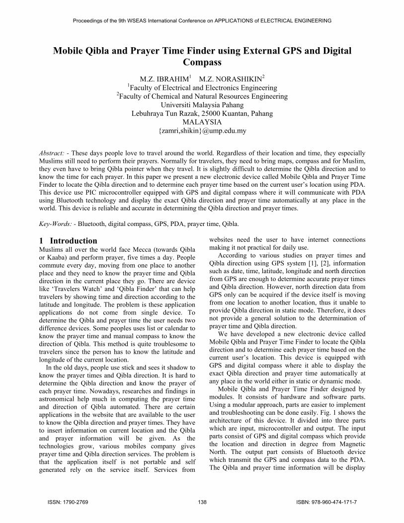
websites need the user to have internet connections making it not practical for daily use. According to various studies on prayer times and Qibla direction using GPS system [1], [2], information such as date, time, latitude, longitude and north direction from GPS are enough to determine accurate prayer times and Qibla direction. However, north direction data from GPS only can be acquired if the device itself is moving from one location to another location, thus it unable to provide Qibla direction in static mode. Therefore, it does not provide a general solution to the determination of prayer time and Qibla direction. We have developed a new electronic device called Mobile Qibla and Prayer Time Finder to locate the Qibla direction and to determine each prayer time based on the current user’s location. This device is equipped with GPS and digital compass where it able to display the exact Qibla direction and prayer time automatically at any place in the world either in static or dynamic mode. Mobile Qibla and Prayer Time Finder designed by modules. It consists of hardware and software parts. Using a modular approach, parts are easier to implement and troubleshooting can be done easily. Fig. 1 shows the architecture of this device. It divided into three parts which are input, microcontroller and output. The input parts consist of GPS and digital compass which provide the location and direction in degree from Magnetic North. The output part consists of Bluetooth device which transmit the GPS and compass data to the PDA. The Qibla and prayer time information will be display
Proceedings of the 9th WSEAS International Conference on APPLICATIONS of ELECTRICAL ENGINEERING
ISSN: 1790-2769 138 ISBN: 978-960-474-171-7
on the PDA based on the data (direction, latitude and longitude) received by the Bluetooth.
Fig. 1 Architecture of Mobile Qibla and Prayer Time Finder
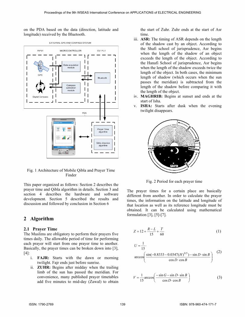
This paper organized as follows: Section 2 describes the prayer time and Qibla algorithm in details. Section 3 and section 4 describes the hardware and software development. Section 5 described the results and discussion and followed by conclusion in Section 6 2 Algorithm 2.1 Prayer Time The Muslims are obligatory to perform their prayers five times daily. The allowable period of time for performing each prayer will start from one prayer time to another. Basically, the prayer times can be broken down into [3], [4]:
i. FAJR: Starts with the dawn or morning twilight. Fajr ends just before sunrise.
ii. ZUHR: Begins after midday when the trailing limb of the sun has passed the meridian. For convenience, many published prayer timetables add five minutes to mid-day (Zawal) to obtain
the start of Zuhr. Zuhr ends at the start of Asr time.
iii. ASR: The timing of ASR depends on the length of the shadow cast by an object. According to the Shafi school of jurisprudence, Asr begins when the length of the shadow of an object exceeds the length of the object. According to the Hanafi School of jurisprudence, Asr begins when the length of the shadow exceeds twice the length of the object. In both cases, the minimum length of shadow (which occurs when the sun passes the meridian) is subtracted from the length of the shadow before comparing it with the length of the object.
iv. MAGHRIB: Begins at sunset and ends at the start of Isha.
v. ISHA: Starts after dusk when the evening twilight disappears.
Fig. 2 Period for each prayer time The prayer times for a certain place are basically different from another. In order to calculate the prayer times, the information on the latitude and longitude of that location as well as its reference longitude must be obtained. It can be calculated using mathematical formulation [3], [5]-[7].
601512 TLRZ
(1)
BDBDH
U
coscossinsin))(0347.08333.0sin(arccos
151
5.0 (2)
BD
BDGVcoscos
sinsinsinarccos151 (3)
Proceedings of the 9th WSEAS International Conference on APPLICATIONS of ELECTRICAL ENGINEERING
ISSN: 1790-2769 139 ISBN: 978-960-474-171-7
BDBDDBarc
W
coscossinsin)))tan(1cot(sin(arccos
151
(4)
BDBDDBarc
X
coscossinsin)))tan(2cot(sin(arccos
151
(5)
where B = Latitude of place L = Longitude of place R = Reference longitude (TIME BAND x 15) H = Height above sea level in meters D = Declination angle of sun T = Equation of time G = Twilight angle
and
Fajr = Z-V Sunrise = Z-U Zuhr = Z Asr1 (Shafi) = Z+W Asr2 (Hanafi) = Z+X Maghrib/Sunset = Z+U Isha = Z+V
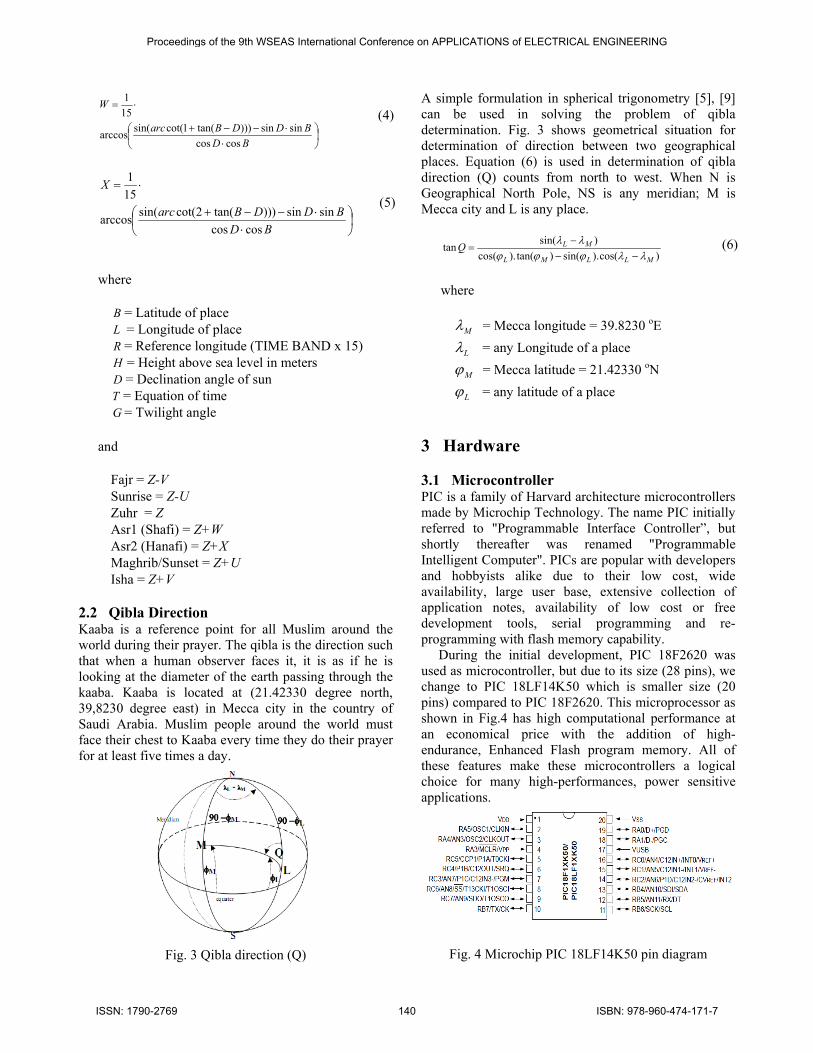
2.2 Qibla Direction Kaaba is a reference point for all Muslim around the world during their prayer. The qibla is the direction such that when a human observer faces it, it is as if he is looking at the diameter of the earth passing through the kaaba. Kaaba is located at (21.42330 degree north, 39,8230 degree east) in Mecca city in the country of Saudi Arabia. Muslim people around the world must face their chest to Kaaba every time they do their prayer for at least five times a day.
Fig. 3 Qibla direction (Q)
A simple formulation in spherical trigonometry [5], [9] can be used in solving the problem of qibla determination. Fig. 3 shows geometrical situation for determination of direction between two geographical places. Equation (6) is used in determination of qibla direction (Q) counts from north to west. When N is Geographical North Pole, NS is any meridian; M is Mecca city and L is any place.
)cos().sin()tan().cos()sin(tan
MLLML
MLQ
(6)
where
M = Mecca longitude = 39.8230 oE
L = any Longitude of a place
M = Mecca latitude = 21.42330 oN
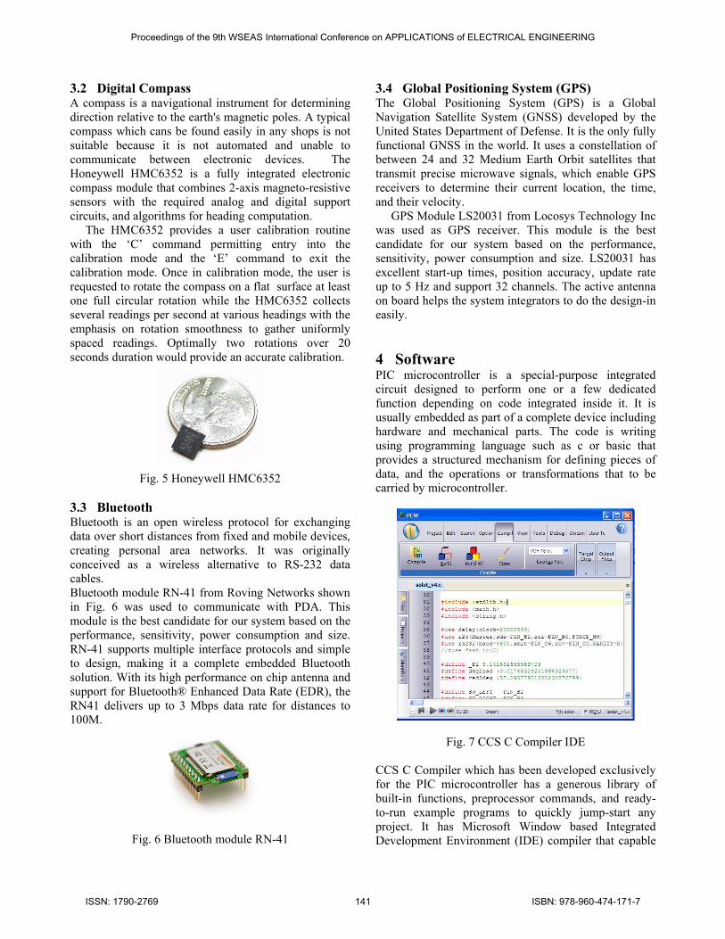
L = any latitude of a place 3 Hardware 3.1 Microcontroller PIC is a family of Harvard architecture microcontrollers made by Microchip Technology. The name PIC initially referred to "Programmable Interface Controller”, but shortly thereafter was renamed "Programmable Intelligent Computer". PICs are popular with developers and hobbyists alike due to their low cost, wide availability, large user base, extensive collection of application notes, availability of low cost or free development tools, serial programming and re-programming with flash memory capability. During the initial development, PIC 18F2620 was used as microcontroller, but due to its size (28 pins), we change to PIC 18LF14K50 which is smaller size (20 pins) compared to PIC 18F2620. This microprocessor as shown in Fig.4 has high computational performance at an economical price with the addition of high-endurance, Enhanced Flash program memory. All of these features make these microcontrollers a logical choice for many high-performances, power sensitive applications.
Fig. 4 Microchip PIC 18LF14K50 pin diagram
Proceedings of the 9th WSEAS International Conference on APPLICATIONS of ELECTRICAL ENGINEERING
ISSN: 1790-2769 140 ISBN: 978-960-474-171-7
3.2 Digital Compass A compass is a navigational instrument for determining direction relative to the earth's magnetic poles. A typical compass which cans be found easily in any shops is not suitable because it is not automated and unable to communicate between electronic devices. The Honeywell HMC6352 is a fully integrated electronic compass module that combines 2-axis magneto-resistive sensors with the required analog and digital support circuits, and algorithms for heading computation. The HMC6352 provides a user calibration routine with the ‘C’ command permitting entry into the calibration mode and the ‘E’ command to exit the calibration mode. Once in calibration mode, the user is requested to rotate the compass on a flat surface at least one full circular rotation while the HMC6352 collects several readings per second at various headings with the emphasis on rotation smoothness to gather uniformly spaced readings. Optimally two rotations over 20 seconds duration would provide an accurate calibration.
Fig. 5 Honeywell HMC6352
3.3 Bluetooth Bluetooth is an open wireless protocol for exchanging data over short distances from fixed and mobile devices, creating personal area networks. It was originally conceived as a wireless alternative to RS-232 data cables. Bluetooth module RN-41 from Roving Networks shown in Fig. 6 was used to communicate with PDA. This module is the best candidate for our system based on the performance, sensitivity, power consumption and size. RN-41 supports multiple interface protocols and simple to design, making it a complete embedded Bluetooth solution. With its high performance on chip antenna and support for Bluetooth® Enhanced Data Rate (EDR), the RN41 delivers up to 3 Mbps data rate for distances to 100M.
Fig. 6 Bluetooth module RN-41
3.4 Global Positioning System (GPS) The Global Positioning System (GPS) is a Global Navigation Satellite System (GNSS) developed by the United States Department of Defense. It is the only fully functional GNSS in the world. It uses a constellation of between 24 and 32 Medium Earth Orbit satellites that transmit precise microwave signals, which enable GPS receivers to determine their current location, the time, and their velocity. GPS Module LS20031 from Locosys Technology Inc was used as GPS receiver. This module is the best candidate for our system based on the performance, sensitivity, power consumption and size. LS20031 has excellent start-up times, position accuracy, update rate up to 5 Hz and support 32 channels. The active antenna on board helps the system integrators to do the design-in easily. 4 Software PIC microcontroller is a special-purpose integrated circuit designed to perform one or a few dedicated function depending on code integrated inside it. It is usually embedded as part of a complete device including hardware and mechanical parts. The code is writing using programming language such as c or basic that provides a structured mechanism for defining pieces of data, and the operations or transformations that to be carried by microcontroller.
Fig. 7 CCS C Compiler IDE CCS C Compiler which has been developed exclusively for the PIC microcontroller has a generous library of built-in functions, preprocessor commands, and ready-to-run example programs to quickly jump-start any project. It has Microsoft Window based Integrated Development Environment (IDE) compiler that capable
Proceedings of the 9th WSEAS International Conference on APPLICATIONS of ELECTRICAL ENGINEERING
ISSN: 1790-2769 141 ISBN: 978-960-474-171-7
to aid in program design and editing. Features of the IDE include a color syntax editor, a powerful C Aware Real-time Debugger, RTOS, linker, and a New Project Wizard for peripherals and drivers. 5 Results Figures This section discusses the result obtained. There are four functions that can be applied on the device which are:
i. Prayer times with calculation method selection ii. Qibla and North direction iii. Compass calibration iv. GPS information (date, time latitude, longitude and signal validity)
Fig. 8 shows the hardware of the external GPS and compass system. This system consists of microcontroller, GPS, digital compass and Bluetooth module. In this research, HTC diamond which one of PDA in the market is used to communicate with this system with baud rate of 57600 bps.
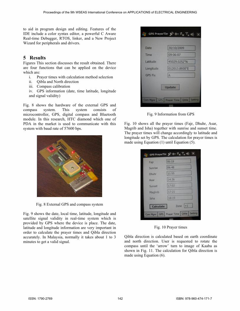
Fig. 8 External GPS and compass system Fig. 9 shows the date, local time, latitude, longitude and satellite signal validity in real-time system which is provided by GPS where the device is place. The date, latitude and longitude information are very important in order to calculate the prayer times and Qibla direction accurately. In Malaysia, normally it takes about 1 to 3 minutes to get a valid signal.
Fig. 9 Information from GPS Fig. 10 shows all the prayer times (Fajr, Dhuhr, Asar, Magrib and Isha) together with sunrise and sunset time. The prayer times will change accordingly to latitude and longitude set by GPS. The calculation for prayer times is made using Equation (1) until Equation (5).
Fig. 10 Prayer times Qibla direction is calculated based on earth coordinate and north direction. User is requested to rotate the compass until the ‘arrow’ turn to image of Kaaba as shown in Fig. 11. The calculation for Qibla direction is made using Equation (6).
Proceedings of the 9th WSEAS International Conference on APPLICATIONS of ELECTRICAL ENGINEERING
ISSN: 1790-2769 142 ISBN: 978-960-474-171-7
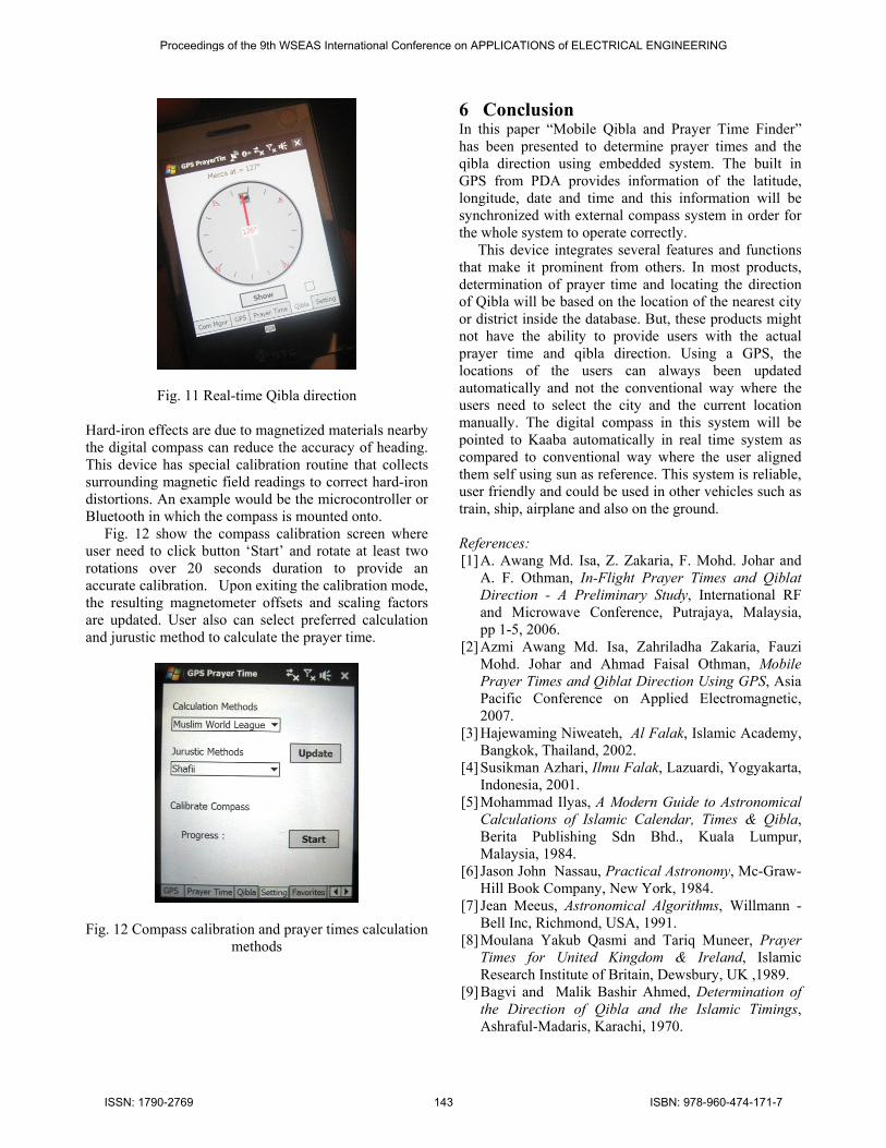
Fig. 11 Real-time Qibla direction Hard-iron effects are due to magnetized materials nearby the digital compass can reduce the accuracy of heading. This device has special calibration routine that collects surrounding magnetic field readings to correct hard-iron distortions. An example would be the microcontroller or Bluetooth in which the compass is mounted onto. Fig. 12 show the compass calibration screen where user need to click button ‘Start’ and rotate at least two rotations over 20 seconds duration to provide an accurate calibration. Upon exiting the calibration mode, the resulting magnetometer offsets and scaling factors are updated. User also can select preferred calculation and jurustic method to calculate the prayer time.
Fig. 12 Compass calibration and prayer times calculation methods
6 Conclusion In this paper “Mobile Qibla and Prayer Time Finder” has been presented to determine prayer times and the qibla direction using embedded system. The built in GPS from PDA provides information of the latitude, longitude, date and time and this information will be synchronized with external compass system in order for the whole system to operate correctly. This device integrates several features and functions that make it prominent from others. In most products, determination of prayer time and locating the direction of Qibla will be based on the location of the nearest city or district inside the database. But, these products might not have the ability to provide users with the actual prayer time and qibla direction. Using a GPS, the locations of the users can always been updated automatically and not the conventional way where the users need to select the city and the current location manually. The digital compass in this system will be pointed to Kaaba automatically in real time system as compared to conventional way where the user aligned them self using sun as reference. This system is reliable, user friendly and could be used in other vehicles such as train, ship, airplane and also on the ground. References: [1] A. Awang Md. Isa, Z. Zakaria, F. Mohd. Johar and
A. F. Othman, In-Flight Prayer Times and Qiblat Direction - A Preliminary Study, International RF and Microwave Conference, Putrajaya, Malaysia, pp 1-5, 2006.
[2] Azmi Awang Md. Isa, Zahriladha Zakaria, Fauzi Mohd. Johar and Ahmad Faisal Othman, Mobile Prayer Times and Qiblat Direction Using GPS, Asia Pacific Conference on Applied Electromagnetic, 2007.
[3] Hajewaming Niweateh, Al Falak, Islamic Academy, Bangkok, Thailand, 2002.
[4] Susikman Azhari, Ilmu Falak, Lazuardi, Yogyakarta, Indonesia, 2001.
[5] Mohammad Ilyas, A Modern Guide to Astronomical Calculations of Islamic Calendar, Times & Qibla, Berita Publishing Sdn Bhd., Kuala Lumpur, Malaysia, 1984.
[6] Jason John Nassau, Practical Astronomy, Mc-Graw-Hill Book Company, New York, 1984.
[7] Jean Meeus, Astronomical Algorithms, Willmann -Bell Inc, Richmond, USA, 1991.
[8] Moulana Yakub Qasmi and Tariq Muneer, Prayer Times for United Kingdom & Ireland, Islamic Research Institute of Britain, Dewsbury, UK ,1989.
[9] Bagvi and Malik Bashir Ahmed, Determination of the Direction of Qibla and the Islamic Timings, Ashraful-Madaris, Karachi, 1970.
Proceedings of the 9th WSEAS International Conference on APPLICATIONS of ELECTRICAL ENGINEERING
ISSN: 1790-2769 143 ISBN: 978-960-474-171-7