Embed Size (px)
Citation preview

2970 Cottage Hill Road, Ste. 190 Mobile, AL 36606
251.666.2443 ph. / 251.666.6422 fax www.thompsonengineering.com
A THOMPSON HOLDINGS, INC. COMPANY
December 20, 2013 Mobile Area Water and Sewer System Dwight McGough, P.E., Planning and Engineering Manager c/o CH2M HILL 25 W. Cedar Street, Suite 560
Pensacola, Florida 32502
Attention: David Muckerman, P.E., BCEE, Project Manager Subject: Report of Geotechnical Field and Laboratory Testing Services
Halls Mill Lift Station SWAT Equalization Basin Vicinity of Riviere Du Chien Road and Interstate Highway 10 Mobile, Mobile County, Alabama
Thompson Project No.: 13-1101-0300 Dear Mr. Muckerman: Thompson Engineering (Thompson) is pleased to present this report in accordance with the scope of services summarized in the Thompson proposal dated December 4, 2013. Objective Perform subsurface exploration and laboratory testing programs for the collection of geotechnical data in support of design/construction of the equalization basin for storage of wet-weather flows at the Halls Mill Lift Station. Project Information Project information was provided to Thompson by CH2M Hill via a Statement of Work document dated November 18, 2013. The project site is located off of Riviere Du Chien Road and approximately 900 feet south of Interstate Highway 10. Underground utilities were located before the commencement of drilling; boring B-2 was relocated approximately 14 feet west due to overhead utilities. Nominal site clearing was required to access boring B-4. The boring coordinates were provided in the SOW document and are illustrated in Plate 1. Borings were staked in the field by Thompson personnel using a handheld GPS unit.

Report of Geotechnical Field and Laboratory Testing Services MAWSS Halls Mill Lift Station, Mobile, Alabama December 20, 2013 Thompson Project No.: 13-1101-0300 Page 2 of 3
Plate 1 – Soil Test Boring Location Plan
Standard Penetration Test (SPT) Borings The field exploration was started and completed on December 11, 2013. The SPT borings were performed in accordance with ASTM Procedure D-1586. Continuous sampling was performed within the upper 10 feet of the subsurface profile and every 5 feet thereafter. A track-mounted drill rig was used to advance the boreholes using hollow stem augers. The total number of blows required to drive the split-spoon sampler the second and third 6-inch increments is designated as the N-value, and provides an indication of in-place soil strength, relative density and consistency. Representative portions of recovered soil samples were transported to Thompson’s geotechnical laboratory facility for classification and stratification by a geotechnical engineer. The results are presented on the attached Records of Test Boring and summarized below. Variations in subsurface soil conditions may occur between soil test boring locations. Recovered samples were not examined, either visually or analytically, for chemical composition or environmental hazards. Soil samples will be available for inspection for a period of 90 days, at which time they will be discarded.
N


0
5
10
15
20
25
30
35
5288
874
111
111
212
222
987
558
111412
81414
57
10
S-1
S-2
S-3
S-4
S-5
S-6
S-7
S-8
S-9
S-10
S-11
SLIGHTLY SILTYSAND (SP-SM)
SILTY SAND (SM)
Dense, fine grained, brown,trace concrete
Medium dense, light brown
Very loose, brown
Very loose
Very loose
Very loose
Medium dense, finegrained, light brown
Medium dense
Medium dense
Medium dense
Medium dense
Boring terminated at 35 feet
36
11
2
2
3
4
15
13
26
28
17
9.5
17.6
10.1
8.2
RECORD OF TEST BORINGBORING NO.: B-1
PROJECT: MAWSS Halls Mill Lift Station SAMPLE METHOD: ASTM D1586 PAGE: 1 of
TYPE BORING: 2 1/4 HSA LAT.: 222596.51
PROJECT NO.: 1311010300 DRILLER: P.Pitts LONG.: 1766952.65
CLIENT: MAWSS and CH2M Hill DRILL RIG: Diedrich D-50 DATE: 12/11/13
LOCATION: Refer to Report Text GWL: 24' ATD WEATHER: Sunny & Cool
ENGINEER: G.Mercer GWL AT 24 HRS.: 22.0' ELEVATION: Not Available
Refer to Notes and Legend on separate sheet for additional information. This Record of Test Boring is part of the project Geotechnical Report.Actual strata changes may be gradual over depth.
DEPTH/ELEV.
SY
MB
OL
SA
MP
LE
R
SP
T
BL
OW
S
SA
MP
LE
I.D
. N
O.
MAJOR SOILCOMPONENT
OTHER COMPONENTS N %F MC LL PI UW OC UU UC PP VS FS
1

0
5
10
15
20
25
222
222
322
223
245
566
224
332
211
S-1
S-2
S-3
S-4
S-5
S-6
S-7
S-8
S-9
SILTY SAND (SM)
SLIGHTLY SILTYSAND (SP-SM)
Very loose, fine grained,brown
Very loose
Very loose, light brown
Loose
Loose
Medium dense
Loose, fine grained, lightbrown
Loose
Very loose, gray
Boring terminated at 25 feet
4
4
4
5
9
12
6
5
2
15.8
17.3
6.6
13.2
RECORD OF TEST BORINGBORING NO.: B-2
PROJECT: MAWSS Halls Mill Lift Station SAMPLE METHOD: ASTM D1586 PAGE: 1 of
TYPE BORING: 2 1/4 HSA LAT.: 222762.48
PROJECT NO.: 1311010300 DRILLER: P.Pitts LONG.: 1767314.68
CLIENT: MAWSS and CH2M Hill DRILL RIG: Diedrich D-50 DATE: 12/11/13
LOCATION: Refer to Report Text GWL: 14' ATD WEATHER: Sunny & Cool
ENGINEER: G.Mercer GWL AT 24 HRS.: 9.58' ELEVATION: Not Available
Refer to Notes and Legend on separate sheet for additional information. This Record of Test Boring is part of the project Geotechnical Report.Actual strata changes may be gradual over depth.
DEPTH/ELEV.
SY
MB
OL
SA
MP
LE
R
SP
T
BL
OW
S
SA
MP
LE
I.D
. N
O.
MAJOR SOILCOMPONENT
OTHER COMPONENTS N %F MC LL PI UW OC UU UC PP VS FS
1

0
5
10
15
20
25
244
322
233
333
566
567
268
67
10
679
S-1
S-2
S-3
S-4
S-5
S-6
S-7
S-8
S-9
SILTY SAND (SM)
SLIGHTLY SILTYSAND (SP-SM)
Loose, fine grained, brown
Very loose
Loose, light brown
Loose
Medium dense, finegrained, light brown
Medium dense
Medium dense
Medium dense
Medium dense
Boring terminated at 25 feet
8
4
6
6
12
13
14
17
16
39.2
8.8
10.5
5.6
RECORD OF TEST BORINGBORING NO.: B-3
PROJECT: MAWSS Halls Mill Lift Station SAMPLE METHOD: ASTM D1586 PAGE: 1 of
TYPE BORING: 2 1/4 HSA LAT.: 222276.95
PROJECT NO.: 1311010300 DRILLER: P.Pitts LONG.: 1767020.76
CLIENT: MAWSS and CH2M Hill DRILL RIG: Diedrich D-50 DATE: 12/11/13
LOCATION: Refer to Report Text GWL: 13.5' ATD WEATHER: Sunny & Cool
ENGINEER: G.Mercer GWL AT 24 HRS.: 9.42' ELEVATION: Not Available
Refer to Notes and Legend on separate sheet for additional information. This Record of Test Boring is part of the project Geotechnical Report.Actual strata changes may be gradual over depth.
DEPTH/ELEV.
SY
MB
OL
SA
MP
LE
R
SP
T
BL
OW
S
SA
MP
LE
I.D
. N
O.
MAJOR SOILCOMPONENT
OTHER COMPONENTS N %F MC LL PI UW OC UU UC PP VS FS
1

0
5
10
15
20
25
30
35
111
122
222
445
566
58
10
789
788
121517
121015
467
S-1
S-2
S-3
S-4
S-5
S-6
S-7
S-8
S-9
S-10
S-11
SILTY SAND (SM)
SLIGHTLY SILTYSAND (SP-SM)
Very loose, fine grained,brown
Very loose
Very loose
Loose, light brown
Medium dense
Medium dense
Medium dense
Medium dense
Dense, fine grained, brown
Medium dense, light brown
Medium dense
Boring terminated at 35 feet
2
4
4
9
12
18
17
16
32
25
13
20.2
15.3
5.6
2.6
RECORD OF TEST BORINGBORING NO.: B-4
PROJECT: MAWSS Halls Mill Lift Station SAMPLE METHOD: ASTM D1586 PAGE: 1 of
TYPE BORING: 2 1/4 HSA LAT.: 222804.16
PROJECT NO.: 1311010300 DRILLER: P.Pitts LONG.: 1766815.70
CLIENT: MAWSS and CH2M Hill DRILL RIG: Diedrich D-50 DATE: 12/11/13
LOCATION: Refer to Report Text GWL: 24' ATD WEATHER: Sunny & Cool
ENGINEER: G.Mercer GWL AT 24 HRS.: 22.42' ELEVATION: Not Available
Refer to Notes and Legend on separate sheet for additional information. This Record of Test Boring is part of the project Geotechnical Report.Actual strata changes may be gradual over depth.
DEPTH/ELEV.
SY
MB
OL
SA
MP
LE
R
SP
T
BL
OW
S
SA
MP
LE
I.D
. N
O.
MAJOR SOILCOMPONENT
OTHER COMPONENTS N %F MC LL PI UW OC UU UC PP VS FS
1

Thompson Engineering
Mobile, Alabama
12/14/13
(no specification provided)
PL= LL= PI=
D90= D85= D60=
D50= D30= D15=
D10= Cu= Cc=
USCS= AASHTO=
*
Very loose, brown
1.51.0.75.50
.375#4
#10#20#40#60
#100#140#200
100.0100.0100.0
90.388.074.967.361.644.426.716.011.9
9.5
12.4675 7.6670 0.77390.5079 0.2789 0.13970.0815 9.49 1.23
SP-SM
Natural Moisture: 10.1%
Mobile Area Water & Sewer Board
MAWSS - Halls Mill LS SWAT
1311010300
Material Description
Atterberg Limits
Coefficients
Classification
Remarks
Source of Sample: B-1 Depth: 3.0Sample Number: S-3 Date:
Client:
Project:
Project No: Figure
SIEVE PERCENT SPEC.* PASS?
SIZE FINER PERCENT (X=NO)
PE
RC
EN
T F
INE
R
0
10
20
30
40
50
60
70
80
90
100
GRAIN SIZE - mm.
0.0010.010.1110100
% +3"Coarse
% Gravel
Fine Coarse Medium
% Sand
Fine Silt
% Fines
Clay
0.0 0.0 25.1 7.6 22.9 34.9 9.5
6 in
.
3 in
.
2 in
.
1½
in
.
1 in
.
¾ in
.
½ in
.
3/8
in
.
#4
#1
0
#2
0
#3
0
#4
0
#6
0
#1
00
#1
40
#2
00
Particle Size Distribution Report

Thompson Engineering
Mobile, Alabama
12/14/13
(no specification provided)
PL= LL= PI=
D90= D85= D60=
D50= D30= D15=
D10= Cu= Cc=
USCS= AASHTO=
*
Medium dense, fine grained, light brown
1.51.0.75.50
.375#4
#10#20#40#60
#100#140#200
100.0100.0100.0100.0100.0100.0100.0
93.462.739.925.419.917.6
0.7651 0.6744 0.40200.3227 0.1821
SM
Natural Moisture: 8.2%
Mobile Area Water & Sewer Board
MAWSS - Halls Mill LS SWAT
1311010300
Material Description
Atterberg Limits
Coefficients
Classification
Remarks
Source of Sample: B-1 Depth: 13.5Sample Number: S-7 Date:
Client:
Project:
Project No: Figure
SIEVE PERCENT SPEC.* PASS?
SIZE FINER PERCENT (X=NO)
PE
RC
EN
T F
INE
R
0
10
20
30
40
50
60
70
80
90
100
GRAIN SIZE - mm.
0.0010.010.1110100
% +3"Coarse
% Gravel
Fine Coarse Medium
% Sand
Fine Silt
% Fines
Clay
0.0 0.0 0.0 0.0 37.3 45.1 17.6
6 in
.
3 in
.
2 in
.
1½
in
.
1 in
.
¾ in
.
½ in
.
3/8
in
.
#4
#1
0
#2
0
#3
0
#4
0
#6
0
#1
00
#1
40
#2
00
Particle Size Distribution Report

Thompson Engineering
Mobile, Alabama
12/14/13
(no specification provided)
PL= LL= PI=
D90= D85= D60=
D50= D30= D15=
D10= Cu= Cc=
USCS= AASHTO=
*
Very loose
1.51.0.75.50
.375#4
#10#20#40#60
#100#140#200
100.0100.0100.0100.0100.0
99.699.594.667.440.124.718.715.8
0.7165 0.6219 0.37000.3073 0.1866
SM
Natural Moisture: 6.6%
Mobile Area Water & Sewer Board
MAWSS - Halls Mill LS SWAT
1311010300
Material Description
Atterberg Limits
Coefficients
Classification
Remarks
Source of Sample: B-2 Depth: 1.5Sample Number: S-2 Date:
Client:
Project:
Project No: Figure
SIEVE PERCENT SPEC.* PASS?
SIZE FINER PERCENT (X=NO)
PE
RC
EN
T F
INE
R
0
10
20
30
40
50
60
70
80
90
100
GRAIN SIZE - mm.
0.0010.010.1110100
% +3"Coarse
% Gravel
Fine Coarse Medium
% Sand
Fine Silt
% Fines
Clay
0.0 0.0 0.4 0.1 32.1 51.6 15.8
6 in
.
3 in
.
2 in
.
1½
in
.
1 in
.
¾ in
.
½ in
.
3/8
in
.
#4
#1
0
#2
0
#3
0
#4
0
#6
0
#1
00
#1
40
#2
00
Particle Size Distribution Report

Thompson Engineering
Mobile, Alabama
12/14/13
(no specification provided)
PL= LL= PI=
D90= D85= D60=
D50= D30= D15=
D10= Cu= Cc=
USCS= AASHTO=
*
Medium dense
1.51.0.75.50
.375#4
#10#20#40#60
#100#140#200
100.0100.0100.0100.0100.0100.0
99.993.258.729.921.018.617.3
0.7720 0.6837 0.43390.3691 0.2504
SM
Natural Moisture: 13.2%
Mobile Area Water & Sewer Board
MAWSS - Halls Mill LS SWAT
1311010300
Material Description
Atterberg Limits
Coefficients
Classification
Remarks
Source of Sample: B-2 Depth: 8.5Sample Number: S-6 Date:
Client:
Project:
Project No: Figure
SIEVE PERCENT SPEC.* PASS?
SIZE FINER PERCENT (X=NO)
PE
RC
EN
T F
INE
R
0
10
20
30
40
50
60
70
80
90
100
GRAIN SIZE - mm.
0.0010.010.1110100
% +3"Coarse
% Gravel
Fine Coarse Medium
% Sand
Fine Silt
% Fines
Clay
0.0 0.0 0.0 0.1 41.2 41.4 17.3
6 in
.
3 in
.
2 in
.
1½
in
.
1 in
.
¾ in
.
½ in
.
3/8
in
.
#4
#1
0
#2
0
#3
0
#4
0
#6
0
#1
00
#1
40
#2
00
Particle Size Distribution Report
Thompson Engineering
Mobile, Alabama
12/14/13
(no specification provided)
PL= LL= PI=
D90= D85= D60=
D50= D30= D15=
D10= Cu= Cc=
USCS= AASHTO=
*
Loose, light brown
1.51.0.75.50
.375#4
#10#20#40#60
#100#140#200
100.0100.0100.0100.0100.0100.0100.0
99.795.284.764.250.339.2
0.3060 0.2525 0.13590.1051
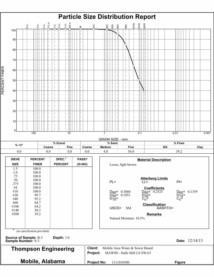
SM
Natural Moisture: 10.5%
Mobile Area Water & Sewer Board
MAWSS - Halls Mill LS SWAT
1311010300
Material Description
Atterberg Limits
Coefficients
Classification
Remarks
Source of Sample: B-3 Depth: 3.0Sample Number: S-3 Date:
Client:
Project:
Project No: Figure
SIEVE PERCENT SPEC.* PASS?
SIZE FINER PERCENT (X=NO)
PE
RC
EN
T F
INE
R
0
10
20
30
40
50
60
70
80
90
100
GRAIN SIZE - mm.
0.0010.010.1110100
% +3"Coarse
% Gravel
Fine Coarse Medium
% Sand
Fine Silt
% Fines
Clay
0.0 0.0 0.0 0.0 4.8 56.0 39.2
6 in
.
3 in
.
2 in
.
1½
in
.
1 in
.
¾ in
.
½ in
.
3/8
in
.
#4
#1
0
#2
0
#3
0
#4
0
#6
0
#1
00
#1
40
#2
00
Particle Size Distribution Report

Thompson Engineering
Mobile, Alabama
12/14/13
(no specification provided)
PL= LL= PI=
D90= D85= D60=
D50= D30= D15=
D10= Cu= Cc=
USCS= AASHTO=
*
Medium dense, fine grained, light brown
1.51.0.75.50
.375#4
#10#20#40#60
#100#140#200
100.0100.0100.0100.0100.0100.0100.0
99.384.747.721.113.0
8.8
0.4778 0.4274 0.29550.2582 0.1858 0.11880.0842 3.51 1.39
SP-SM
Natural Moisture: 5.6%
Mobile Area Water & Sewer Board
MAWSS - Halls Mill LS SWAT
1311010300
Material Description
Atterberg Limits
Coefficients
Classification
Remarks
Source of Sample: B-3 Depth: 6.0Sample Number: S-5 Date:
Client:
Project:
Project No: Figure
SIEVE PERCENT SPEC.* PASS?
SIZE FINER PERCENT (X=NO)
PE
RC
EN
T F
INE
R
0
10
20
30
40
50
60
70
80
90
100
GRAIN SIZE - mm.
0.0010.010.1110100
% +3"Coarse
% Gravel
Fine Coarse Medium
% Sand
Fine Silt
% Fines
Clay
0.0 0.0 0.0 0.0 15.3 75.9 8.8
6 in
.
3 in
.
2 in
.
1½
in
.
1 in
.
¾ in
.
½ in
.
3/8
in
.
#4
#1
0
#2
0
#3
0
#4
0
#6
0
#1
00
#1
40
#2
00
Particle Size Distribution Report

Thompson Engineering
Mobile, Alabama
12/14/13
(no specification provided)
PL= LL= PI=
D90= D85= D60=
D50= D30= D15=
D10= Cu= Cc=
USCS= AASHTO=
*
Very loose
1.51.0.75.50
.375#4
#10#20#40#60
#100#140#200
100.0100.0100.0100.0100.0100.0100.0
95.975.251.132.924.620.2
0.6488 0.5502 0.30440.2435 0.1352
SM
Natural Moisture: 5.6%
Mobile Area Water & Sewer Board
MAWSS - Halls Mill LS SWAT
1311010300
Material Description
Atterberg Limits
Coefficients
Classification
Remarks
Source of Sample: B-4 Depth: 1.5Sample Number: S-2 Date:
Client:
Project:
Project No: Figure
SIEVE PERCENT SPEC.* PASS?
SIZE FINER PERCENT (X=NO)
PE
RC
EN
T F
INE
R
0
10
20
30
40
50
60
70
80
90
100
GRAIN SIZE - mm.
0.0010.010.1110100
% +3"Coarse
% Gravel
Fine Coarse Medium
% Sand
Fine Silt
% Fines
Clay
0.0 0.0 0.0 0.0 24.8 55.0 20.2
6 in
.
3 in
.
2 in
.
1½
in
.
1 in
.
¾ in
.
½ in
.
3/8
in
.
#4
#1
0
#2
0
#3
0
#4
0
#6
0
#1
00
#1
40
#2
00
Particle Size Distribution Report

Thompson Engineering
Mobile, Alabama
12/14/13
(no specification provided)
PL= LL= PI=
D90= D85= D60=
D50= D30= D15=
D10= Cu= Cc=
USCS= AASHTO=
*
Loose, light brown
1.51.0.75.50
.375#4
#10#20#40#60
#100#140#200
100.0100.0100.0100.0100.0100.0
99.995.875.149.929.620.315.3
0.6501 0.5509 0.30880.2508 0.1516
SM
Natural Moisture: 2.6%
Mobile Area Water & Sewer Board
MAWSS - Halls Mill LS SWAT
1311010300
Material Description
Atterberg Limits
Coefficients
Classification
Remarks
Source of Sample: B-4 Depth: 4.5Sample Number: S-4 Date:
Client:
Project:
Project No: Figure
SIEVE PERCENT SPEC.* PASS?
SIZE FINER PERCENT (X=NO)
PE
RC
EN
T F
INE
R
0
10
20
30
40
50
60
70
80
90
100
GRAIN SIZE - mm.
0.0010.010.1110100
% +3"Coarse
% Gravel
Fine Coarse Medium
% Sand
Fine Silt
% Fines
Clay
0.0 0.0 0.0 0.1 24.8 59.8 15.3
6 in
.
3 in
.
2 in
.
1½
in
.
1 in
.
¾ in
.
½ in
.
3/8
in
.
#4
#1
0
#2
0
#3
0
#4
0
#6
0
#1
00
#1
40
#2
00
Particle Size Distribution Report